孟德友 , 李小建
, 李小建
MENG Deyou, LI Xiaojian
收稿日期: 2017-06-21
修回日期: 2017-09-30
网络出版日期: 2018-09-04
版权声明: 2018 地理科学进展 《地理科学进展》杂志 版权所有
基金资助:
作者简介:
作者简介:孟德友(1982- ),男,河南周口人,博士,副教授,主要从事城市与区域经济,空间结构与区域发展研究,E-mail: mengdeyou01@163.com。
展开
摘要
高铁建设虽在较大程度上改善了城市间的时间可达性,但其高票价导致的旅行费用增加在一定程度上限制了人们对高铁的消费预期。从费用可达性和居民对高铁的消费能力两个方面,基于省会城市间2008和2015年的铁路最短旅行时间及相应的票价、城镇居民人均收入数据,采用平均旅行费用、高铁消费能力指数和高铁消费预期指数等指标对省际费用可达性及居民对高铁的消费能力和消费预期进行分析。主要研究结论为:①高铁不同程度上抬升了省会城市间的旅行费用,费用可达性空间格局从以郑州、济南为中心的核心—边缘型空间格局转变为以呼和浩特、太原为中心的核心—边缘型空间格局;②大多数城市的居民高铁消费能力得到了不同程度的提升,但高铁消费能力和消费预期都呈现出东中部优于西部和东北部地区的不均衡分布特征。本文可对优化高铁供给格局进而对提升高铁的利用效率具有一定的参考价值。
关键词:
Abstract
Although accessibility in terms of travel time has improved to a great extent under the construction of high-speed rail, people's consumption expectations of high-speed rail are limited by the raise of travel cost caused by the high ticket price of high-speed rail. From the perspective of cost accessibility and people's consumption capacity of high-speed rail, the level and change of inter-provincial cost accessibility, people's consumption capacity, and consumption expectations are calculated and analyzed by average travel cost, high-speed rail consumption capacity index, and high-speed rail consumption expectation index, based on the data of shortest travel time and corresponding railway fares between provincial capital cities, and per capita income of urban residents in 2008 and 2015. The results show that: (1) Travel cost accessibility has improved to different degrees under the construction of high-speed rail in china, and the spatial pattern of cost accessibility has been transformed from the "core-periphery" pattern with Zhengzhou-Jinan as the cores and other provinces as the peripheries to the "core-periphery" pattern with Hohehot-Taiyuan as the cores and other provinces as the peripheries; (2) People's consumption capacity of high-speed rail in the majority of provincial capital cities has increased to different degrees, while the level of consumption capacity and consumption expectation in central and eastern China is superior to the western and Northeast China. The research can provide some references for optimizing the service provision and improving the efficiency of the high-speed rail system.
Keywords:
自京津城际高速铁路开通以来中国进入了高速铁路的大发展时期,在中国《中长期铁路网规划(2008年调整)》确定的“四纵四横”总体规划框架下,相继建成胶济、石太、合武、武广、郑西、福厦、京沪等高速铁路,截至2015年底,全国高速铁路通车里程达1.9万km,占世界高速铁路总里程的60%以上,成为世界上拥有高铁最长和发展速度最快的国家。2016年国家发改委印发的《中长期铁路网规划》指出,在“四纵四横”高速铁路的基础上到2030年拟建成“八纵八横”主通道为骨架、区域连接线衔接、城际铁路补充的高速铁路网。高速铁路作为一种发展较快的新兴交通方式,其最直接的影响是缩短地区间的旅行时间,对城市联通性、生产要素流动和区域发展产生重要影响。国内外对高速铁路建设的空间经济效应也给予了高度关注,主要集中在高铁建设对城市可达性(Jiao et al, 2014)、要素流动(吴康等, 2013)和城市空间结构(王姣娥等, 2014; 焦敬娟等, 2016)的影响等方面,尤其在高速铁路的可达性效应方面已从国家间、国内、区域和地方等多个时空尺度展开探讨并积累了不少成果。
跨国空间尺度的研究主要聚焦于欧洲和东亚等地,通过欧洲高速铁路对区域便捷性及差异的影响研究认为,高速铁路的发展极大地缩短了城市间的旅行时间,导致区域差异的扩大,形成明显的核心—边缘结构(Vickerman et al, 1999; Gutiérrez, 2001)。Coto-Millan等(2007)分析了欧盟范围内高铁发展后欧洲中部城市的网络可达性变化;国内金凤君等(2016)、马颖忆等(2015)分别评价了东亚高速铁路建设对城市交通圈和可达性的影响,以及泛亚高铁建设对西南边疆地区与中南半岛空间联系的影响。国家层面的研究,多集中于高铁对全国范围内城市可达性的影响分析,高铁网络发展引起可达性格局演变或研究城市到首都中心城市的可达性(Kim, 2000; Chen et al, 2012; Sánchez-Mateos et al, 2012)。Sasaki等(1997)研究了日本兴建新干线所引起的可达性变化及其对区域经济和人口扩散作用的影响。国内有学者采用加权平均旅行时间、平均可达性等指标对高铁时代中国省际可达性、省会城市一日交流圈的空间格局进行了探讨(孟德友等, 2011; 冯长春等, 2013; 钟业喜等, 2015)。在区域尺度研究方面,多采用GIS技术和网络分析法比较有无高铁及铁路提速前后的区域可达性格局变化(蒋海兵等, 2010; 赵丹等, 2012; 姜博等, 2014; 汪德根等, 2015),包括高铁建设对沿线城市可达性、城市群城际可达性的影响等。
大量研究认为,高铁能显著改善区域间的时间可达性,提高通达效率,扩大中心城市的影响范围,对区域空间结构及城市区位优势产生强烈的影响;但从旅行费用看,高铁票价高,高票价造成高速列车上座率低、居民对高铁的消费预期不足,制约了高铁的普及;所以仅从时间节约来讨论高铁的空间效益,而忽视高铁较高的旅行费用,则会在很大程度上夸大高铁的空间经济效益。张萌萌等(2014)根据城市总收入、城市间平均旅行时间和发车频次数据重新定义市场潜力函数,探讨了市场潜力特征及高铁对城市市场潜力的提升效应,是该领域国内较早的成果;蒋海兵等(2015)采用可达性指数与标准交通经济成本探究了高铁与出行成本影响下的全国陆路可达性;张凯烊等(2016)以京沪高铁沿线城市为例,根据各城市时间节省的货币成本与小时工资作比较,并结合高铁车次比重计算了不同城市居民“被高铁”的可能性,成为国内高铁旅行费用研究的代表性成果;黄洁等(2016)利用省会城市交通时间及相应票价比较了普通铁路旅行服务价格和高速铁路旅行服务价格,分析了高铁对省会城市经济可达性的影响及居民的消费能力。尽管如此,对高铁旅行费用可达性研究还相对较为薄弱,对高铁建设中城市费用可达性及其空间格局变化的研究则更少。基于此,以2008年和2015年铁路旅行费用和城镇居民收入数据为基础,采用平均旅行费用、边际费用均值、高铁消费能力和高铁消费预期指数等指标,分析高铁建设对全国省会城市间费用可达性及其对居民高铁消费预期的影响,以期为优化高铁供给格局和提升高铁利用效率提供理论参考。
2.2.1 平均旅行费用
平均旅行费用是指在铁路客运交通网络设施下某城市到达区域其他城市的旅行费用的平均值,其计算公式为(黄洁等, 2016):
式中:Ci表示i城市通过铁路客运系统到达区域内其他城市的平均旅行费用,可用来表明i城市的铁路供给价格,Ci值越小,表示i城市的费用可达性水平越优,居民对铁路服务的消费期望就越大,反之则费用可达性越差,居民对铁路服务的消费期望也越小;Cij表示i城市到达j城市的铁路客运票价;n为区域内与i城市相联系的城市数。
2.2.2 相对费用指数
借鉴时间相对可达性的概念,提出相对费用指数为城市平均费用可达性与铁路客运网络中各城市该项指标平均值的比值,反映城市在整个网络中费用可达性相对地位的高低,表达式为:
式中:Ci'表示i城市的相对费用指数,值小于1表示该城市的费用可达性优于区域平均水平,值越小表示该城市的费用可达性水平越优,反之则越差;N为区域内城市总数。
2.2.3 边际费用均值
边际费用均值是在借鉴张凯烊等(2016)研究中的“旅客节省的单位时间价值”及黄洁等(2016)研究中的“小时经济额度”基础上提出的,可定义为某城市与铁路网络中开通高铁的城市间单位旅行时间节约所增加的旅行费用的平均,即旅行时间节约与旅行费用增加的比值的平均值,表达式为:
式中:Ri表示i城市的边际费用均值,可反映铁路供给的性价比,值越小,表示i城市的铁路服务性价比越高,反之,则越低;Cij表示i城市与开通高铁的j城市间的旅行费用;Tij表示i城市与j城市间的最短旅行时间;m表示与i城市开通高铁的城市数。
2.2.4 高铁消费能力指数
为刻画居民对高铁的消费可能性和消费水平,构建高铁消费能力指数模型,可用平均旅行费用占该城市居民月收入的比重来表示,其表达式为:
式中:CAi表示i城市居民的高铁消费能力指数,值越小,表示居民的高铁消费能力越强,反之则越低;MIi表示i城市居民的月平均收入,其他参数同上。
2.2.5 高铁消费预期指数
为进一步刻画居民对高铁的消费预期和潜能,构建高铁消费预期指数,具体用边际费用均值占居民小时收入的比重来表示,其表达式为:
式中:CEi表示i城市居民的高铁消费预期指数,值越大,表示居民的高铁消费倾向越弱,反之则越强;HIi表示i城市居民的小时平均收入,这里采用2015年城镇居民小时平均收入表示,以2015年的月平均实际工作日并按每日8小时工作制进行计算得到,其他参数同上。
文中所采用的城市间铁路旅行费用数据分别由石开网络科技有限公司推出的石开旅行时刻表(2008年10月14日)和极品列车时刻表(2015年9月26日)查询获得。在查询的过程中遵循以下原则,①考虑到省会城市往往是各省市区的经济中心和对外交往的门户,所以选择省会城市为各省市区的质心节点,以31个省会城市为研究对象(包括27个省会城市和4个直辖市,暂不包括香港、澳门和台北);②如果两省会城市间有直通的旅客列车班次,则选择所有旅客列车班次中旅行时间最短者为两省会城市间的旅行时间,以该班次对应的旅行费用为两城市间的旅行费用;③高速列车包括D字头和谐号动车组列车,G字头高速动车组和C字头城际列车,其他类型的列车统归为普通列车,高速列车的旅行费用取二等座票价,普通列车的旅行费用取硬座票价;④如果两省会城市间无直通列车,则以最短旅行时间为准则选择中转站进行中转,旅行费用取相应列车班次的票价之和,暂不考虑中转过程中的待车和滞留时间;由此可得全国除香港、澳门和台北之外的31个省会城市间的最短旅行时间和最小旅行费用矩阵。另外,所涉及到的社会经济数据主要来源于相关省市2009年的统计年鉴和2016年各省市区的国民经济和社会发展公报等,暂不考虑价格因素对铁路票价和城镇居民收入的影响。
由于高速铁路的票价及单位里程费用高于普通列车的票价(表1),随着高速铁路的开通运营,不少城市的费用可达性值都得到较大幅度的抬升。2008-2015年间,全国省会城市间的平均旅行费用由235元增加到的389.3元,增长65.7%,高速铁路在大幅度缩短地区间旅行时间的同时也在较大程度上抬升城市间的旅行费用成本。2008年费用可达性水平较优的前五位城市依次为郑州、济南、西安、太原和合肥,平均旅行费用都在185元以内,而费用可达性水平较差的后五位城市依次为拉萨、乌鲁木齐、海口、哈尔滨和长春,平均旅行费用都在290元以上(表2),费用可达性在全国平均水平以上的省会城市18个,相对费用指数小于1,银川市的费用可达性与全国平均水平相当,拉萨市的相对费用指数高达1.73(表3);2015年费用可达性水平较优的前五位城市为呼和浩特、太原、西安、昆明和兰州,平均旅行费用都在295元以内,而旅行费用可达性水平较差的后五位城市为贵阳、南宁、哈尔滨、拉萨和福州,平均旅行费用都在480元以上,相对费用指数小于1的城市增至19个,费用可达性最差的贵阳市的平均旅行费用为623.1元,相对费用指数达1.60。两个年份各省会城市平均旅行费用的标准差分别为59.2和93.5,变异系数分别为0.252和0.240,表明省会城市间平均旅行费用提升的过程中呈均衡发展的态势。
表1 2015年主要线路普通列车和高速铁路的票价和单位里程费用
Tab.1 Ticket price and per kilometers cost of main conventional and high-speed rail lines, 2015
| 线路 | 票价/元 | 单位里程费用/(元/km) | ||||||
|---|---|---|---|---|---|---|---|---|
| 普通列车硬座 | D字头二等座 | G字头二等座 | 普通列车硬座 | D字头二等座 | G字头二等座 | |||
| 四纵 | 北京—上海 | 167 | 309 | 533 | 0.11 | 0.21 | 0.40 | |
| 北京—深圳 | 255 | 756 | 937 | 0.11 | 0.31 | 0.38 | ||
| 北京—哈尔滨 | 159 | 310 | 501 | 0.12 | 0.25 | 0.38 | ||
| 上海—广州 | 197 | 502 | 793 | 0.11 | 0.29 | 0.47 | ||
| 四横 | 郑州—西安 | 68 | 154 | 233 | 0.12 | 0.30 | 0.46 | |
| 杭州—贵阳 | 213 | — | 662 | 0.11 | — | 0.40 | ||
| 青岛—济南 | 53 | 120 | 119 | 0.14 | 0.31 | 0.30 | ||
| 上海—成都 | 274 | 606 | — | 0.11 | 0.31 | — | ||
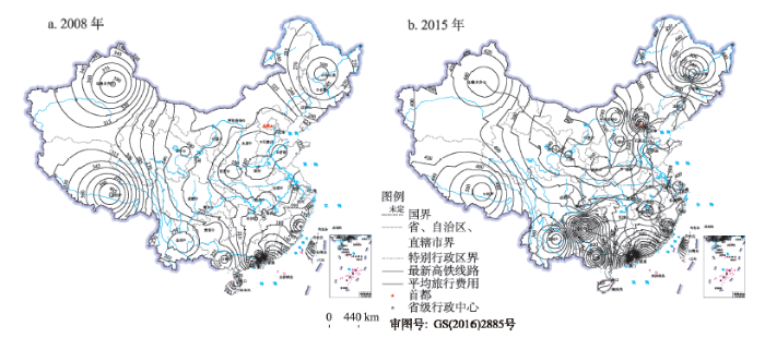
以省会城市的平均旅行费用对省际费用可达性空间格局进行分析(图1),2008-2015年间省际平均旅行费用总体上呈现出以郑州、济南为中心向外围地区逐渐增大的核心—边缘型空间格局,向以呼和浩特、太原为中心向外围地区逐渐增大的核心—边缘型空间格局转变。2008年,包括河南、山东、山西、陕西、安徽、湖北、湖南、江苏和江西等在内的中部大部分地区构成省际费用可达性的低值区,其省际平均旅行费用在200元以内,由此向外围地区逐步增大,尤以昆明、哈尔滨、乌鲁木齐、拉萨等为中心的西南、东北、西北和西南边陲地区与全国大多数省会城市间的旅行距离和旅行时间均较高,而且与不少省会城市之间甚至尚未开行直通列车班次,导致这些地区的平均旅行费用在280元以上。随着高速铁路的建成和高速列车的开行,2015年,东中部不少省会城市之间大规模开通了高速列车,在较大幅度上抬升了东中部地区的省际旅行费用,郑州、武汉、合肥、长沙、南京和石家庄等不少省会城市的平均旅行费用大幅度提升,而这一时期呼和浩特、太原和银川等城市与不少省会城市增开的主要是直通普通列车班次,旅行费用增加幅度不大,内蒙古、陕西、山西和甘肃在内地部分地区构成费用可达性的低值区,其费用可达性值在300元以内,由此向外围分别形成以北京、哈尔滨、广州、福州、拉萨、南宁和贵阳为中心的费用高值区,其平均旅行费用都在450元以上。
图1 2008和2015年省际费用可达性空间格局
Fig.1 Spatial pattern of provincial capital cities travel cost accessibility in China in 2008 and 2015
从平均旅行费用和相对费用指数的变化幅度,对各省会城市的费用可达性变化及其成因进行分析(表2,表3),2008-2015年间各省会城市旅行费用平均增加了154.3元,15个省会城市的平均旅行费用增加幅度在平均变化幅度以上,贵阳、南宁、哈尔滨、北京和福州等的变化幅度在240元以上,相对变化率在79.5%以上,最高的贵阳市的平均旅行费用增加了374.3元,相对变化率高达150.4%;变化幅度低于全国平均变化幅度的16个城市中,昆明、呼和浩特、乌鲁木齐、兰州和海口等的平均旅行费用增加幅度在80元以内,相对变化率在30%以内,最低的昆明市的平均旅行费用增加幅度仅1.8元,相对变化率为0.6%。相对费用指数越小表明城市在网络中的费用可达性地位越高。相对费用指数减小的13个城市中,乌鲁木齐、昆明、拉萨、海口和呼和浩特的相对费用指数减小幅度在0.3以上,表明这些城市的费用可达性水平在提升,西安的费用可达性水平保持不变;在相对费用指数增大的17个城市中,贵阳、南宁、北京、济南和南昌等的相对费用指数提升幅度都在0.2以上,表明这些城市的费用可达性水平在降低。费用可达性是由高铁的单位里程旅行费用、高铁的通达里程和城市在全国的空间地理区位共同影响的结果,城市开通高速列车的数量越多(北京、合肥、长沙、上海等),或者城市所处的地理位置越边缘(贵阳、南宁、哈尔滨等),与其他省会城市的旅行距离越大,则该城市的旅行费用增加幅度就会越大。
表2 2008和2015年省际费用可达性及变化
Tab.2 Level and change of provincial capital cities travel cost accessibility, 2008 and 2015
| 城市 | 2008年省际费用可达性/元 | 2015年省际费用可达性/元 | 变化幅度/元 | 变化率/% | 城市 | 2008年省际费用可达性/元 | 2015年省际费用可达性/元 | 变化幅度/元 | 变化率/% |
|---|---|---|---|---|---|---|---|---|---|
| 北京 | 209.1 | 454.4 | 245.3 | 117.3 | 郑州 | 164.8 | 307.4 | 142.6 | 86.5 |
| 上海 | 204.4 | 415.2 | 210.8 | 103.1 | 武汉 | 197.5 | 358.6 | 161.1 | 81.6 |
| 天津 | 194.5 | 313.5 | 119.0 | 61.2 | 长沙 | 195.3 | 368.2 | 172.9 | 88.5 |
| 重庆 | 216.6 | 343.1 | 126.5 | 58.4 | 广州 | 243.1 | 474.1 | 231.0 | 95.0 |
| 石家庄 | 186.6 | 318.9 | 132.3 | 70.9 | 南宁 | 275.5 | 594.7 | 319.2 | 115.9 |
| 太原 | 180.3 | 262.7 | 82.4 | 45.7 | 海口 | 315.3 | 391.4 | 76.1 | 24.1 |
| 呼和浩特 | 223.9 | 245.3 | 21.4 | 9.6 | 成都 | 212.1 | 375.0 | 162.9 | 76.8 |
| 沈阳 | 255.3 | 354.6 | 99.3 | 38.9 | 贵阳 | 248.8 | 623.1 | 374.3 | 150.4 |
| 长春 | 293.1 | 414.4 | 121.3 | 41.4 | 昆明 | 284.1 | 285.9 | 1.8 | 0.6 |
| 哈尔滨 | 308.8 | 554.2 | 245.4 | 79.5 | 拉萨 | 405.9 | 510.0 | 104.1 | 25.6 |
| 南京 | 195.2 | 366.4 | 171.2 | 87.7 | 西安 | 172.3 | 284.7 | 112.4 | 65.2 |
| 杭州 | 209.9 | 378.5 | 168.6 | 80.3 | 兰州 | 224.4 | 294.5 | 70.1 | 31.2 |
| 合肥 | 184.6 | 361.8 | 177.2 | 96.0 | 西宁 | 244.0 | 344.1 | 100.1 | 41.0 |
| 福州 | 241.2 | 483.7 | 242.5 | 100.5 | 银川 | 236.1 | 329.8 | 93.7 | 39.7 |
| 南昌 | 198.3 | 422.2 | 223.9 | 112.9 | 乌鲁木齐 | 390.6 | 453.8 | 63.2 | 16.2 |
| 济南 | 172.0 | 384.2 | 212.2 | 123.4 | 平均值 | 235.0 | 389.3 | 154.3 | 65.7 |
表3 2008和2015年相对费用可达性及变化
Tab.3 Level and change of provincial capital cities relative travel cost accessibility, 2008 and 2015
| 城市 | 2008年 | 2015年 | 变化幅度 | 城市 | 2008年 | 2015年 | 变化幅度 |
|---|---|---|---|---|---|---|---|
| 北京 | 0.89 | 1.17 | 0.28 | 郑州 | 0.70 | 0.79 | 0.09 |
| 上海 | 0.87 | 1.07 | 0.20 | 武汉 | 0.84 | 0.92 | 0.08 |
| 天津 | 0.83 | 0.81 | -0.02 | 长沙 | 0.83 | 0.95 | 0.12 |
| 重庆 | 0.92 | 0.88 | -0.04 | 广州 | 1.03 | 1.22 | 0.19 |
| 石家庄 | 0.79 | 0.82 | 0.03 | 南宁 | 1.17 | 1.53 | 0.36 |
| 太原 | 0.77 | 0.67 | -0.10 | 海口 | 1.34 | 1.01 | -0.33 |
| 呼和浩特 | 0.95 | 0.63 | -0.32 | 成都 | 0.90 | 0.96 | 0.06 |
| 沈阳 | 1.09 | 0.91 | -0.18 | 贵阳 | 1.06 | 1.60 | 0.54 |
| 长春 | 1.25 | 1.06 | -0.19 | 昆明 | 1.21 | 0.73 | -0.48 |
| 哈尔滨 | 1.31 | 1.42 | 0.11 | 拉萨 | 1.73 | 1.31 | -0.42 |
| 南京 | 0.83 | 0.94 | 0.11 | 西安 | 0.73 | 0.73 | 0.00 |
| 杭州 | 0.89 | 0.97 | 0.08 | 兰州 | 0.95 | 0.76 | -0.19 |
| 合肥 | 0.79 | 0.93 | 0.14 | 西宁 | 1.04 | 0.88 | -0.16 |
| 福州 | 1.03 | 1.24 | 0.21 | 银川 | 1.00 | 0.85 | -0.15 |
| 南昌 | 0.84 | 1.08 | 0.24 | 乌鲁木齐 | 1.66 | 1.17 | -0.49 |
| 济南 | 0.73 | 0.99 | 0.26 |
边际费用是指省会城市之间由于高速铁路的开通运营带来的单位旅行时间的节约所导致的旅行费用的增加,在一定程度上能反映高速铁路提升城市时间可达性机会成本的高低。根据省会城市间的最短旅行时间及旅行费用,对各城市的边际费用均值进行测算与比较发现(表4),2008-2015年全国高铁大发展期间各城市的边际费用均值为69.9元/小时,边际费用均值在全国平均值以上的6个城市中,沈阳、北京、兰州和西宁在100元/小时以上,最高的沈阳高达428.5元/小时,北京高达281.8元/小时;而作为全国主要的铁路枢纽城市北京在2008年已与不少城市开通了D字头动车组列车(2008年北京已与上海、天津、石家庄、沈阳、长春等10多个城市开通了D字头动车组列车),2015年G字头高速动车组的开通在时间上并未再次明显改善其时间可达性,但在票价上抬高的幅度较大,造成了边际费用较高。比如,2008年沈阳与北京的D字头动车组与2015年的G字头高速列车在旅行时间上仅相差1分钟,而在票价上却相差140元,这也是造成沈阳和北京边际费用高的一个重要原因,当然这也在一定程度上反应了高铁定价的不甚合理。边际费用均值在全国平均水平以下的25个城市中,太原、成都、福州、重庆和银川的边际费用均值不到30元/小时,边际费用均值的大小在很大程度上也受规模经济效应影响,主要体现在:一方面与其对开高铁的城市数越多,其边际费用均值则会越低,对开高铁的城市数越少,其边际费用均值则可能会越高。如南京、合肥和武汉等与20多个省会城市开通了高速列车,边际费用均值则相对较低;而呼和浩特、兰州、沈阳和西宁等对开高铁的城市数较少,其边际费用均值则较高;另一方面,边际费用还受空间距离和旅行时间的显著影响,在区位上位居边缘地区的铁路终端省会城市与全国大多数省会城市的空间距离和旅行时间较大,高铁的建设使这类城市的旅行时间缩减的幅度较大,进而分摊到单位旅行时间节约所带来的费用增加则相对较小,边际费用均值相应较低,比如成都、福州、重庆、乌鲁木齐和昆明等边际费用均值都比较低。
表4 城市边际费用均值和开通高铁城市数
Tab.4 Marginal cost and high-speed rail linkages of provincial capital cities
| 城市 | 边际费用均值/(元/小时) | 开通高铁 城市数 | 城市 | 边际费用均值/(元/小时) | 开通高铁 城市数 |
|---|---|---|---|---|---|
| 北京 | 281.8 | 23 | 郑州 | 47.8 | 16 |
| 上海 | 62.2 | 19 | 武汉 | 33.6 | 22 |
| 天津 | 68.5 | 14 | 长沙 | 46.8 | 19 |
| 重庆 | 25.8 | 15 | 广州 | 39.1 | 17 |
| 石家庄 | 47.2 | 12 | 南宁 | 46.1 | 21 |
| 太原 | 21.2 | 13 | 海口 | 43.2 | 11 |
| 呼和浩特 | 65.3 | 2 | 成都 | 22.6 | 19 |
| 沈阳 | 428.5 | 12 | 贵阳 | 61.2 | 23 |
| 长春 | 61.6 | 14 | 昆明 | 34.1 | 3 |
| 哈尔滨 | 81.2 | 17 | 拉萨 | 47.2 | 12 |
| 南京 | 35.1 | 20 | 西安 | 40.2 | 13 |
| 杭州 | 39.7 | 19 | 兰州 | 139.2 | 6 |
| 合肥 | 42.9 | 22 | 西宁 | 107.6 | 12 |
| 福州 | 24.4 | 21 | 银川 | 27.9 | 10 |
| 南昌 | 71.2 | 21 | 乌鲁木齐 | 30.0 | 9 |
| 济南 | 42.8 | 21 |
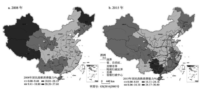
高铁的服务对象是面向区域的全体旅客,各省会城市的旅客流也不仅限于各城市内部居民,而是来自于全省甚至省外其他地区,考虑到农村居民的交通消费水平还比较低(2008年全国农村居民交通信息消费平均360.18元,相当于城镇居民的25.4%;2014年全国农村居民交通信息消费平均1012.6元,相当于城镇居民的38.4%),在此以各省区城镇居民为潜在的铁路客源,来考察居民对高铁服务的消费能力。根据各城市平均旅行费用和月平均收入水平,对2008年和2015年各城市居民高铁消费能力指数进行测算,并根据各年份各城市的平均消费能力指数的0.5倍、1倍、1.5倍将各城市的高铁消费能力分为四类,其中,小于平均消费能力指数0.5倍的为高,介于平均消费能力指数0.5~1倍的为较高,介于平均消费能力指数1~1.5倍的为较低,大于平均消费能力指数1.5倍的为低。2008年各城市高铁消费能力指数的平均值为18.8%,北京和上海的高铁消费能力最强,平均旅行费用占月平均收入的比重在9.4%以内;高铁消费能力较强的城市主要集中在东部沿海地区、中部地区以及西部地区的呼和浩特和成都,其高铁消费能力指数介于10.1%~18.6%之间;高铁消费能力较差的城市主要集中在东北、西南和西北地区,海口的高铁消费能力也较低;哈尔滨、拉萨和乌鲁木齐的高铁消费能力最低,其高铁消费能力指数在30%以上(图2),月收入可供消费高铁的能力不到4次。随着各城市平均旅行费用的抬升和月平均收入的增加,2015年各省会城市高铁消费能力水平发生了较大的变化,各城市高铁消费能力指数的平均值为16.1%,高铁消费能力较强的城市主要集中在东部地区、中西部地区以及呼和浩特和昆明等19个城市,其高铁消费能力指数介于9.4%~10.1%之间;高铁消费能力较低的城市主要集中在东北、西北以及华南等地共10个城市,高铁消费能力指数介于16.4%~24%之间;南宁和贵阳的高铁消费能力最差,其高铁消费能力指数高达27%以上,月平均收入可供消费高铁的能力不足4次,很大程度上由于这些地区的居民收入水平较低所造成的,如贵阳市2015年城镇居民月平均收入仅2048元,仅相当于位居全国首位的上海市的46%。
图2 2008和2015年各城市居民高铁消费能力空间格局
Fig.2 Spatial pattern of high-speed rail consumption capacity of provincial capital cities, 2008 and 2015
进一步对各城市高铁消费能力的变化态势进行分析发现(表5),2015年18个城市的高铁消费能力得到了不同程度的提升,其高铁消费能力指数平均减少了6个百分点,尤其是海口、昆明、拉萨和乌鲁木齐的消费能力指数减少了10个百分点以上,最高的乌鲁木齐的高铁消费能力指数从2008年的37.6%降低到2015年的20.7%。居民收入水平增长的速度高于平均旅行费用增长的速度是这些城市高铁消费能力增强的主要原因,包括海口、昆明、拉萨、乌鲁木齐、兰州和呼和浩特等城市对外开通高铁的城市还比较少,尤其昆明、呼和浩特等城市与大多数城市增开的主要是直通普通列车,这些城市的平均旅行费用增加的幅度相对较低,进而增强了这些地区的高铁消费能力。12个城市的高铁消费能力发生了不同程度的降低,其高铁消费能力指数平均提升幅度为2.1个百分点,贵阳、南宁、广州、济南和福州的高铁消费能力指数增加了2.5个百分点以上,尤其是贵阳和南宁两地的高铁消费能力指数增加了5个百分点以上,长昆客运专线贵阳至长沙段、贵广高铁和南广高铁的建成通车极大地提升了贵州和南宁两地的高铁通达性,同时也在较大幅度上抬升了其省际平均旅行费用,加上这些地区居民收入水平增长幅度较小,导致这些城市的高铁消费能力较大程度地降低。天津市在研究期间的高铁消费能力保持稳定。
表5 2008和2015年各省区居民高铁消费能力指数及变化(单位:%)
Tab.5 Level and change of high-speed rail consumption capacity of provincial capital cities/%, 2008 and 2015
| 城市 | 2008年 | 2015年 | 变化幅度 | 城市 | 2008年 | 2015年 | 变化幅度 |
|---|---|---|---|---|---|---|---|
| 北京 | 9.1 | 10.3 | 1.2 | 郑州 | 14.2 | 14.4 | 0.2 |
| 上海 | 8.2 | 9.4 | 1.2 | 武汉 | 16.7 | 15.9 | -0.8 |
| 天津 | 11.0 | 11.0 | 0.0 | 长沙 | 16.1 | 15.3 | -0.8 |
| 重庆 | 17.1 | 15.1 | -2.0 | 广州 | 13.5 | 16.4 | 2.9 |
| 石家庄 | 15.8 | 14.6 | -1.2 | 南宁 | 21.5 | 27.0 | 5.5 |
| 太原 | 15.6 | 12.2 | -3.4 | 海口 | 27.8 | 17.8 | -10.0 |
| 呼和浩特 | 17.7 | 9.6 | -8.1 | 成都 | 18.6 | 17.2 | -1.4 |
| 沈阳 | 19.3 | 13.7 | -5.6 | 贵阳 | 24.5 | 30.4 | 5.9 |
| 长春 | 25.8 | 20.0 | -5.8 | 昆明 | 24.1 | 13.0 | -11.1 |
| 哈尔滨 | 30.2 | 21.3 | -8.9 | 拉萨 | 35.7 | 24.0 | -11.7 |
| 南京 | 11.6 | 11.8 | 0.2 | 西安 | 14.9 | 12.9 | -2.0 |
| 杭州 | 10.1 | 10.4 | 0.3 | 兰州 | 23.1 | 14.9 | -8.2 |
| 合肥 | 15.6 | 16.1 | 0.5 | 西宁 | 22.8 | 16.8 | -6.0 |
| 福州 | 14.7 | 17.4 | 2.7 | 银川 | 20.1 | 15.7 | -4.4 |
| 南昌 | 17.7 | 19.1 | 1.4 | 乌鲁木齐 | 37.6 | 20.7 | -16.9 |
| 济南 | 11.8 | 14.6 | 2.8 |
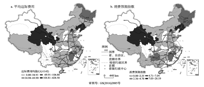
各城市居民对高铁的预期消费倾向除受居民高铁消费能力制约之外,很大程度上还受单位旅行时间节约所引致的机会成本高低的影响,即高铁提速提价的性价比或单位时间内旅行费用的增加与单位时间收入水平的比较。对各城市居民高铁消费预期指数进行测算并根据各城市平均高铁消费预期指数的0.5倍、1倍和1.5倍将各城市的高铁消费预期水平分为四类,其中,小于各城市平均高铁消费预期指数0.5倍的为高,介于各城市平均高铁消费预期指数0.5~1.0倍的为较高,介于各城市平均高铁消费预期指数1.0~1.5倍的为较低,大于各城市平均高铁消费预期指数1.5倍的为低。各城市的平均高铁消费预期指数为4.7,其中,包括福州、太原、成都、杭州、南京、重庆、银川、广州和乌鲁木齐9城市的边际费用均值较低,居民高铁消费预期指数在2.35以内,高铁提速提价的性价比高,居民消费预期水平也高(表6、图3);中西部、西南部地区城市以及上海、呼和浩特等14个城市的居民高铁消费预期指数介于2.4~4.37之间,高铁提速提价的性价比较高,居民高铁消费预期水平也较高,需要指出的是上海市的边际费用均值虽然较高,但其小时平均收入2015年居全国首位高达25.9元,对高铁提价的承受能力较强;长春、贵阳、哈尔滨和南昌的小时收入水平较低加上较高的边际费用均值,导致这些城市居民对高铁提价的承受能力较弱,高铁消费预期指数介于5.06~5.50之间,高铁消费预期水平较低;西宁、北京、兰州和沈阳四市因其高昂的边际费用均值,这些城市的高铁消费预期指数都在8.98以上,最高的沈阳市高达28.19,居民对高铁提价的承受能力和预期消费水平都很低。
表6 城市居民高铁消费预期指数
Tab.6 High-speed rail consumption expectation of provincial capital cities in the future
| 城市 | 小时平均收入/元 | 消费预期 指数 | 城市 | 小时平均收入/元 | 消费预期 指数 |
|---|---|---|---|---|---|
| 北京 | 25.8 | 10.9 | 郑州 | 12.5 | 3.8 |
| 上海 | 25.9 | 2.4 | 武汉 | 13.2 | 2.5 |
| 天津 | 16.7 | 4.1 | 长沙 | 14.1 | 3.3 |
| 重庆 | 13.3 | 1.9 | 广州 | 17.0 | 2.3 |
| 石家庄 | 12.8 | 3.7 | 南宁 | 12.9 | 3.6 |
| 太原 | 12.6 | 1.7 | 海口 | 12.9 | 3.4 |
| 呼和浩特 | 14.9 | 4.4 | 成都 | 12.8 | 1.8 |
| 沈阳 | 15.2 | 28.2 | 贵阳 | 12.0 | 5.1 |
| 长春 | 12.2 | 5.1 | 昆明 | 12.9 | 2.7 |
| 哈尔滨 | 15.2 | 5.3 | 拉萨 | 12.4 | 3.8 |
| 南京 | 18.2 | 1.9 | 西安 | 12.9 | 3.1 |
| 杭州 | 21.3 | 1.9 | 兰州 | 11.6 | 12.0 |
| 合肥 | 13.2 | 3.3 | 西宁 | 12.0 | 9.0 |
| 福州 | 16.3 | 1.5 | 银川 | 12.3 | 2.3 |
| 南昌 | 12.9 | 5.5 | 乌鲁木齐 | 12.8 | 2.3 |
| 济南 | 15.4 | 2.8 |
图3 各城市平均边际费用和居民高铁消费预期空间格局
Fig.3 Spatial pattern of average marginal cost and consumption expectation
作为一种发展速度较快的新兴交通运输方式,高铁的大规模建设对提升城市间的时间可达性,重构城市经济联系格局,加速城市间资源要素流动具有重要影响。但高铁的高票价也在较大程度上导致高速列车的上座率和使用率较低。以省会城市间的旅行费用为切入点对全国省际间的旅行费用可达性以及居民对高铁的消费能力和消费倾向进行比较分析,得到以下几点认识:
(1) 高铁的开通运营导致不少省会城市的省际旅行费用不同程度的提升,尤其是对开高铁城市数越多的城市或者所处地理位置越边缘、与其他城市旅行距离越大的城市的费用可达性值增幅越大。省际平均旅行费用表现出由以郑州、济南为中心向外围地区逐渐增大的核心—边缘型空间格局,转变为以呼和浩特、太原为中心向外围地区逐渐增大的核心—边缘型空间格局,这是由各地区高铁建设的时序、高铁路网发育水平和通达水平、单位里程费用和城市的空间区位等因素共同作用的结果。
(2) 居民对高铁的消费能力与各城市的平均旅行费用和各城市的居民收入水平密切相关,费用可达性值越小或收入水平越高的城市居民对高铁的消费能力越强,各城市居民对高铁的消费能力水平总体上呈现出以东、中部地区为核心向西部、东南和东北部地区降低的趋势。居民对高铁的消费预期很大程度上受旅行时间节约的机会成本的影响,边际费用均值越小或单位时间内收入水平高的城市居民的高铁消费倾向越强,在此暂未考虑消费者的消费行为和消费观念对高铁消费倾向的影响。
(3) 虽然人们在出行方式的选择中越来越注重时间的节约和效率的提高,费用成本对人们出行方式的影响有所减弱,但对于收入水平较低的地区或群体而言,旅行费用仍是影响其出行方式的重要因素。高铁建设虽然显著地改善了城市间的时间可达性,但高票价却在很大程度上限制了高铁的普及使用,结合地区的费用可达性状况和居民对高铁的消费倾向优化高铁的规划建设布局、调整高铁的供给价格,是铁路建设和管理部门应给予高度关注的问题。
(4) 高铁的规划建设在很大程度上缩短了城市间的旅行时间,但也提升了旅行费用成本,针对当前学界从时间压缩的视角而过于肯定高铁的可达性效应,本文从费用可达性的视角展开高铁费用可达性研究,有益于弥补高铁可达性研究的不足,有助于全面而综合地考量高铁的空间经济效应水平。但为了更深入地探究高铁的费用可达性及变化状况,还有待于进一步聚焦全国地级城市以及高铁沿线的县市,以深化对高铁费用可达性的进一步研究,为优化高铁供给格局、提高高铁的利用效率提供理论参考。
The authors have declared that no competing interests exist.
| [1] |
高速铁路对中国省际可达性的影响 [J].https://doi.org/10.11820/dlkxjz.2013.08.002 URL [本文引用: 1] 摘要
National High-Speed Rail Grid (4+4) Passenger Dedicated Lines (PDL) Railway Planning, covering all provincial capital cities and more than 90% cities with populations of more than 500,000, will be up and running in 2015. Accessibility by high speed railway network has become a hot topic in the accessibility research field. In this paper, based on review of the methods used by other researchers, the shortest time distance matrix between provincial capital cities was chosen to analyze inter-provincial accessibility by conventional railway network and by high-speed railway network, and weighted average travel time was used to analyze inter-provincial accessibility and spatial pattern in the high-speed railway time. Results are shown as fellows: (1) Inter-provincial accessibility by conventional railway network obtained with shortest time distance (including transfer and short-stay) has a "center-periphery" spatial pattern, with Zhengzhou-Wuhan as the center and other provinces as peripheries. The accessibility decreases from center to peripheries in circular gradients. The dominant factors affecting the accessibility are network pattern, node location and train organization, as Beijing has higher accessibility with radial rail network. (2) Inter-provincial accessibility by high-speed railway network also has a "center-periphery" pattern, whileWuhan is more convenient than Zhengzhou. Passenger Dedicated Lines have shortened inter- provincial travel time and doubled the 2% areas of best accessibility (from 5.3 10 km to 10.8 10 km), showing the effects of high-speed railway network. The average travel distance of each capital city is 60,000 kilometers by both conventional network and high-speed railway network, but the latter only costs half of total travel time as the former, while the area of the best accessibility is 108,000 square kilometers. (3) High-speed railway network will equalize inter-province accessibility, as standard deviation of accessibility coefficient is less than conventional railway network. Remote regions such as Yunnan and Fujian had the biggest improvement in accessibility while the center provinces had littles change.
Effects of high speed railway network on the inter-provincial accessibilities in China [J].https://doi.org/10.11820/dlkxjz.2013.08.002 URL [本文引用: 1] 摘要
National High-Speed Rail Grid (4+4) Passenger Dedicated Lines (PDL) Railway Planning, covering all provincial capital cities and more than 90% cities with populations of more than 500,000, will be up and running in 2015. Accessibility by high speed railway network has become a hot topic in the accessibility research field. In this paper, based on review of the methods used by other researchers, the shortest time distance matrix between provincial capital cities was chosen to analyze inter-provincial accessibility by conventional railway network and by high-speed railway network, and weighted average travel time was used to analyze inter-provincial accessibility and spatial pattern in the high-speed railway time. Results are shown as fellows: (1) Inter-provincial accessibility by conventional railway network obtained with shortest time distance (including transfer and short-stay) has a "center-periphery" spatial pattern, with Zhengzhou-Wuhan as the center and other provinces as peripheries. The accessibility decreases from center to peripheries in circular gradients. The dominant factors affecting the accessibility are network pattern, node location and train organization, as Beijing has higher accessibility with radial rail network. (2) Inter-provincial accessibility by high-speed railway network also has a "center-periphery" pattern, whileWuhan is more convenient than Zhengzhou. Passenger Dedicated Lines have shortened inter- provincial travel time and doubled the 2% areas of best accessibility (from 5.3 10 km to 10.8 10 km), showing the effects of high-speed railway network. The average travel distance of each capital city is 60,000 kilometers by both conventional network and high-speed railway network, but the latter only costs half of total travel time as the former, while the area of the best accessibility is 108,000 square kilometers. (3) High-speed railway network will equalize inter-province accessibility, as standard deviation of accessibility coefficient is less than conventional railway network. Remote regions such as Yunnan and Fujian had the biggest improvement in accessibility while the center provinces had littles change.
|
| [2] |
基于高铁网络的中国省会城市经济可达性 [J].https://doi.org/10.11821/dlyj201604013 URL [本文引用: 2] 摘要
基于列车时刻表中的省会城市间交通时间以及相应票价数据和各省市城镇居民家庭人均收入数据,以铁路服务价格、城镇居民消费铁路服务能力两方面为突破口,分析高铁网络对中国省会城市经济可达性的影响.结果表明:①高铁网络不同程度地提升了省会城市铁路服务价格,降低了铁路服务价格与时间可达性的相关性,同时改变了铁路服务价格的分布格局.②城镇居民消费铁路服务能力等级差异明显,其中收入水平发挥着决定性作用,而铁路服务价格的影响也不容忽视.③高铁网络缩小了“所有城市”铁路服务价格、铁路服务消费能力分布的不公平性,但扩大了“高铁城市”铁路服务价格、铁路服务消费能力分布的不公平性;铁路服务消费能力分布的不公平程度高于铁路服务价格分布的不公平程度.
Economic accessibility of provincial capital cities in China based on the presence of high-speed rails [J].https://doi.org/10.11821/dlyj201604013 URL [本文引用: 2] 摘要
基于列车时刻表中的省会城市间交通时间以及相应票价数据和各省市城镇居民家庭人均收入数据,以铁路服务价格、城镇居民消费铁路服务能力两方面为突破口,分析高铁网络对中国省会城市经济可达性的影响.结果表明:①高铁网络不同程度地提升了省会城市铁路服务价格,降低了铁路服务价格与时间可达性的相关性,同时改变了铁路服务价格的分布格局.②城镇居民消费铁路服务能力等级差异明显,其中收入水平发挥着决定性作用,而铁路服务价格的影响也不容忽视.③高铁网络缩小了“所有城市”铁路服务价格、铁路服务消费能力分布的不公平性,但扩大了“高铁城市”铁路服务价格、铁路服务消费能力分布的不公平性;铁路服务消费能力分布的不公平程度高于铁路服务价格分布的不公平程度.
|
| [3] |
高速铁路影响下的城市可达性测度及其空间格局模拟分析: 以哈大高铁为例 [J].High-speed railway impact on the measure of urban accessibility and its spatial pattern simulation analysis: A case of Harbin-Dalian high-speed rail [J]. |
| [4] |
京沪高铁对区域中心城市陆路可达性影响 [J].The influence of Beijing-Shanghai high-speed railways on land accessibility of regional center cities [J]. |
| [5] |
高速铁路与出行成本影响下的全国陆路可达性分析 [J].The Land accessibility influenced by China's high-speed rail network and travel cost [J]. |
| [6] |
高速铁路对城市网络结构的影响研究: 基于铁路客运班列分析 [J].https://doi.org/10.11821/dlxb201602007 URL [本文引用: 1] 摘要
城市网络是近年来城市与区域研究的一个新方向。基于2003-2013年间8个横截面的中国铁路客运班列数据,采用加权度中心性和社区结构模型,探讨高速铁路建设对城市等级和集聚性空间格局及演化的影响。研究表明:1基于铁路客运组织的城市等级结构呈现出位序—规模分布的特征和集聚性,且三大地带和各社区内城市也呈现出明显的位序—规模分布,随着高速铁路网络的扩展,加权度中心性的集聚性更明显,并逐步呈现出较为明显的层级结构和社区结构。2城市等级结构呈现出明显的东中西地带性、廊道效应和经济、人口的耦合性,即基于铁路客运班列的城市等级结构与基于属性数据(人口/GDP)的结果表现出较大的相似性,但也存在一定的差异。城市社区结构与中国高速铁路网络、城市群的空间分布格局基本一致。随着高速铁路的建设,东中西三大地带间城市等级的差异呈扩大态势,但各社区间城市等级的差异呈缩小态势,部分社区核心城市已形成。
Impact of high-speed rail on inter-city network based on the passenger train network in China, 2003-2013 [J].https://doi.org/10.11821/dlxb201602007 URL [本文引用: 1] 摘要
城市网络是近年来城市与区域研究的一个新方向。基于2003-2013年间8个横截面的中国铁路客运班列数据,采用加权度中心性和社区结构模型,探讨高速铁路建设对城市等级和集聚性空间格局及演化的影响。研究表明:1基于铁路客运组织的城市等级结构呈现出位序—规模分布的特征和集聚性,且三大地带和各社区内城市也呈现出明显的位序—规模分布,随着高速铁路网络的扩展,加权度中心性的集聚性更明显,并逐步呈现出较为明显的层级结构和社区结构。2城市等级结构呈现出明显的东中西地带性、廊道效应和经济、人口的耦合性,即基于铁路客运班列的城市等级结构与基于属性数据(人口/GDP)的结果表现出较大的相似性,但也存在一定的差异。城市社区结构与中国高速铁路网络、城市群的空间分布格局基本一致。随着高速铁路的建设,东中西三大地带间城市等级的差异呈扩大态势,但各社区间城市等级的差异呈缩小态势,部分社区核心城市已形成。
|
| [7] |
东亚高速铁路网络的发展演化与地理效应评价 [J].https://doi.org/10.11821/dlxb201604004 URL 摘要
经济全球化和区域一体化进程的不断推进,促使东亚在世界经济中的地位不断提升。高速铁路作为促进经济一体化和区域发展的重要手段和基础,其快速发展势必会对东亚地区的区域发展、空间结构、人口流动和一体化产生重大影响。在分析东亚高速铁路网络发展历程及服务水平的基础上,评价与对比了高速铁路建设对城市交通圈和可达性的影响,及一体化高速铁路潜在的空间效应,以期为东亚一体化高速铁路构建提供指导。结果表明:东亚高速铁路网络扩张整体上呈现出"核心—核心"到网络化的发展历程;高速铁路网络在中国东中部、日本和韩国等地区具有较高的人口和产业服务水平,但国土面积覆盖率相对较低;高速铁路的建设促使核心城市交通圈格局不断扩展与强化,可实现当日往返城市对数量明显增加,主要分布在中国长三角、珠三角,日本东京和韩国汉城周边;中国大陆、日本和韩国的加权平均旅行时间分别呈现出以郑州、东京和汉城为中心的"核心—边缘"结构,且圈层结构逐渐向高速铁路沿线延伸;高速铁路的建设促使城市人口服务水平和可达性的空间格局均呈现出明显的"廊道效应"。
Evolution and geographic effects of high-speed rail in East Asia [J].https://doi.org/10.11821/dlxb201604004 URL 摘要
经济全球化和区域一体化进程的不断推进,促使东亚在世界经济中的地位不断提升。高速铁路作为促进经济一体化和区域发展的重要手段和基础,其快速发展势必会对东亚地区的区域发展、空间结构、人口流动和一体化产生重大影响。在分析东亚高速铁路网络发展历程及服务水平的基础上,评价与对比了高速铁路建设对城市交通圈和可达性的影响,及一体化高速铁路潜在的空间效应,以期为东亚一体化高速铁路构建提供指导。结果表明:东亚高速铁路网络扩张整体上呈现出"核心—核心"到网络化的发展历程;高速铁路网络在中国东中部、日本和韩国等地区具有较高的人口和产业服务水平,但国土面积覆盖率相对较低;高速铁路的建设促使核心城市交通圈格局不断扩展与强化,可实现当日往返城市对数量明显增加,主要分布在中国长三角、珠三角,日本东京和韩国汉城周边;中国大陆、日本和韩国的加权平均旅行时间分别呈现出以郑州、东京和汉城为中心的"核心—边缘"结构,且圈层结构逐渐向高速铁路沿线延伸;高速铁路的建设促使城市人口服务水平和可达性的空间格局均呈现出明显的"廊道效应"。
|
| [8] |
泛亚高铁建设对中国西南边疆地区与中南半岛空间联系的影响 [J].https://doi.org/10.11821/dlyj201505003 URL 摘要
泛亚高铁建设是中国"走出去"战略的重要手段,能够助推中国与中南半岛及东南亚地区的跨境合作。从可达性变化和空间格局演变两方面,探讨了泛亚高铁建设对中国西南(陆域)边疆地区与中南半岛空间联系的影响。结果表明:高铁建设带来可达性在全局和局域层面显著的时空收敛,同时也在一定程度上降低了区域内部的相对差异情况,使各区域享受交通的便捷程度更趋均衡;对区内国土面积、人口与GDP等的服务水平提升并呈现国别分异的层次结构特征;凸显高铁过境市州尤其是昆明的区位优势,以及高铁中线建设对区域一体化的推动作用;强化了中国西南边疆尤其是过境市州与中南半岛的空间联系强度,并形成昆明(曲靖)—曼谷,昆明(曲靖)—河内围合的"
"型主导联系格局。 The influence of Pan-Asia high-speed railway construction on spatial relation between Southwest China's frontier area and Indo-China Peninsula [J].https://doi.org/10.11821/dlyj201505003 URL 摘要
泛亚高铁建设是中国"走出去"战略的重要手段,能够助推中国与中南半岛及东南亚地区的跨境合作。从可达性变化和空间格局演变两方面,探讨了泛亚高铁建设对中国西南(陆域)边疆地区与中南半岛空间联系的影响。结果表明:高铁建设带来可达性在全局和局域层面显著的时空收敛,同时也在一定程度上降低了区域内部的相对差异情况,使各区域享受交通的便捷程度更趋均衡;对区内国土面积、人口与GDP等的服务水平提升并呈现国别分异的层次结构特征;凸显高铁过境市州尤其是昆明的区位优势,以及高铁中线建设对区域一体化的推动作用;强化了中国西南边疆尤其是过境市州与中南半岛的空间联系强度,并形成昆明(曲靖)—曼谷,昆明(曲靖)—河内围合的"
"型主导联系格局。 |
| [9] |
高速铁路建设对我国省际可达性空间格局的影响 [J].Impacts of high-speed railway on the spatial pattern of the regional accessibility in China [J]. |
| [10] |
高速铁路对长三角地区都市圈可达性影响 [J].https://doi.org/10.15957/j.cnki.jjdl.2015.02.008 URL [本文引用: 1] 摘要
利用成本加权栅格法分析非高铁与高铁条件下长三角地区5大都市圈的最短旅行时间的可达性和一日交流圈等时圈格局变化。结果显示:1都市圈高铁站点城市成为时间收敛最大受益者,非站点城市可达性也有所提高,但幅度较小。25大都市圈等时圈均沿高铁线呈轴向态势向外推移明显,表明高铁对都市圈空间拓展具有较强的轴向引导作用。3高铁扩展了5大都市圈一日交流圈范围,覆盖范围几乎达到100%,1h和2h等时圈覆盖范围均有不同程度扩展,表明高铁条件下,都市圈内部城市以及都市圈之间重要核心城市的时间距离拉近,实现跨城市当日流动,形成"同城效应"。
The influence of high-speed railways on accessibility of Yangtze River Delta region's metropolitans [J].https://doi.org/10.15957/j.cnki.jjdl.2015.02.008 URL [本文引用: 1] 摘要
利用成本加权栅格法分析非高铁与高铁条件下长三角地区5大都市圈的最短旅行时间的可达性和一日交流圈等时圈格局变化。结果显示:1都市圈高铁站点城市成为时间收敛最大受益者,非站点城市可达性也有所提高,但幅度较小。25大都市圈等时圈均沿高铁线呈轴向态势向外推移明显,表明高铁对都市圈空间拓展具有较强的轴向引导作用。3高铁扩展了5大都市圈一日交流圈范围,覆盖范围几乎达到100%,1h和2h等时圈覆盖范围均有不同程度扩展,表明高铁条件下,都市圈内部城市以及都市圈之间重要核心城市的时间距离拉近,实现跨城市当日流动,形成"同城效应"。
|
| [11] |
高速铁路对中国城市空间相互作用强度的影响 [J].Spatial effects of high-speed rails on interurban economic linkages in China [J]. |
| [12] |
京津城际高速铁路影响下的跨城流动空间特征 [J].The intercity space of flow influenced by high-spaced rail: A case study for the rail transit passenger behavior between Beijing and Tianjin [J]. |
| [13] |
“被高铁”现象的理性分析: 以京沪高铁为例 [J].https://doi.org/10.18306/dlkxjz.2016.04.010 URL [本文引用: 1] 摘要
近年来,中国高铁步入快速建设期,而高铁建设的重要目的之一就是客货分流.高铁客运专线的建设大大地提升了客运能力,从而可以释放既有线路的运输能力于货物运输.但是高铁客运的票价也高于既有线路,同时由于普通列车车次的减少,使得居民出行可能要被迫选择票价更高的高铁,这种现象称作“被高铁”.本文对媒体关注的“被高铁”现象进行了理性分析,以京沪高铁沿线城市为例,根据2015年1月1日列车时刻表数据计算出的时间节省的货币成本与小时工资(时间价值)作比较,并结合高铁车次比重,计算了不同城市的居民“被高铁”的可能性.研究发现:①很多“城市对”之间都存在时间节省的货币成本高于小时工资的情况,“被高铁”现象较为普遍;②“被高铁”的可能性在50%左右;③各城市“被高铁”的程度有较大差异,京沪高铁沿线城市的“被高铁程度”整体呈现出“两头低,中段高,长三角相对较低”的特征.研究认为,虽然从目前来看,京沪高铁沿线城市的普通列车班次减少不明显,但如果进行较大幅度调整,很多低收入旅客出行时可能会被迫选择高铁,并将带来负面的社会影响.本文的理性分析可为列车班次的调整方案提供参考.
“Involuntary high-speed railway travel”: A case study based on the Beijing-Shanghai high-speed railway [J].https://doi.org/10.18306/dlkxjz.2016.04.010 URL [本文引用: 1] 摘要
近年来,中国高铁步入快速建设期,而高铁建设的重要目的之一就是客货分流.高铁客运专线的建设大大地提升了客运能力,从而可以释放既有线路的运输能力于货物运输.但是高铁客运的票价也高于既有线路,同时由于普通列车车次的减少,使得居民出行可能要被迫选择票价更高的高铁,这种现象称作“被高铁”.本文对媒体关注的“被高铁”现象进行了理性分析,以京沪高铁沿线城市为例,根据2015年1月1日列车时刻表数据计算出的时间节省的货币成本与小时工资(时间价值)作比较,并结合高铁车次比重,计算了不同城市的居民“被高铁”的可能性.研究发现:①很多“城市对”之间都存在时间节省的货币成本高于小时工资的情况,“被高铁”现象较为普遍;②“被高铁”的可能性在50%左右;③各城市“被高铁”的程度有较大差异,京沪高铁沿线城市的“被高铁程度”整体呈现出“两头低,中段高,长三角相对较低”的特征.研究认为,虽然从目前来看,京沪高铁沿线城市的普通列车班次减少不明显,但如果进行较大幅度调整,很多低收入旅客出行时可能会被迫选择高铁,并将带来负面的社会影响.本文的理性分析可为列车班次的调整方案提供参考.
|
| [14] |
高速铁路对中国城市市场潜力的影响: 基于铁路客运可达性的分析 [J].https://doi.org/10.11820/dlkxjz.2014.12.008 URL 摘要
In the past ten years, high-speed railway has rapidly developed in China and its effect on urban development is gradually revealed. This paper explores the impact of high-speed railway on market potential of 268 Chinese cites at the prefecture level or above in 2012. First, market potential function is redefined based on the average travel time and train frequency between 268 cities obtained from the railway train schedules. Second, to examine the high-speed railway effect this research compares market potential of cities with and without highspeed railway. Existing studies of high-speed railway effect have primarily focused on its contribution to time saving and paid little attention to increased train frequency. In this paper, both travel time and train frequency are analyzed. The results show that: (1) Market potential of Chinese cities without high-speed railway exhibits a multi-center and corridor structure. Cities with high values of market potential are mainly located in the Yangtze River Delta Region, Pearl River Delta Region, Beijing-Tianjin-Hebei Region, and along some major railway lines such as the Beijing-Guangzhou Railway Line, Beijing-Shanghai Railway Line, and Beijing-Harbin Railway Line; (2) Market potential with high-speed railway also presents a multi-center and corridor structure, but has higher densities around the centers; (3) the high-speed railway effect of cities along the Beijing-Shanghai Railway Line, Shanghai-Hangzhou Railway Line, and Ningbo-Xiamen Special Railway Line is most pronounced, which significantly facilitates the growth of market potential in these cities; (4) The average value of the timesaving effect of 109 cities connected by high-speed railway is 31.3% and the average value of frequency effect is 68.7%, which is the most significant part of the high-speed railway effect.
Impact of high-speed railway on market potential of Chinese cities: Analyses based on railway passenger transport accessibility [J].https://doi.org/10.11820/dlkxjz.2014.12.008 URL 摘要
In the past ten years, high-speed railway has rapidly developed in China and its effect on urban development is gradually revealed. This paper explores the impact of high-speed railway on market potential of 268 Chinese cites at the prefecture level or above in 2012. First, market potential function is redefined based on the average travel time and train frequency between 268 cities obtained from the railway train schedules. Second, to examine the high-speed railway effect this research compares market potential of cities with and without highspeed railway. Existing studies of high-speed railway effect have primarily focused on its contribution to time saving and paid little attention to increased train frequency. In this paper, both travel time and train frequency are analyzed. The results show that: (1) Market potential of Chinese cities without high-speed railway exhibits a multi-center and corridor structure. Cities with high values of market potential are mainly located in the Yangtze River Delta Region, Pearl River Delta Region, Beijing-Tianjin-Hebei Region, and along some major railway lines such as the Beijing-Guangzhou Railway Line, Beijing-Shanghai Railway Line, and Beijing-Harbin Railway Line; (2) Market potential with high-speed railway also presents a multi-center and corridor structure, but has higher densities around the centers; (3) the high-speed railway effect of cities along the Beijing-Shanghai Railway Line, Shanghai-Hangzhou Railway Line, and Ningbo-Xiamen Special Railway Line is most pronounced, which significantly facilitates the growth of market potential in these cities; (4) The average value of the timesaving effect of 109 cities connected by high-speed railway is 31.3% and the average value of frequency effect is 68.7%, which is the most significant part of the high-speed railway effect.
|
| [15] |
高速铁路影响下的长三角城市群可达性空间格局演变 [J].Research into spatial pattern changes of Yangtze River Delta's accessibility under the impact of high-speed railway [J]. |
| [16] |
高铁对中国城市可达性格局的影响分析 [J].https://doi.org/10.1083/jcb.201208150 URL [本文引用: 1] 摘要
Railway is an important way of transportation to combine Chinese cities, and its upgrading plays an important role in improving spatial pattern of cities' accessibility. Having selected prefecture-level cities as study objects and extracted the shortest-time distances between every two central cites based on data from train schedule, the article calculated the accessibility of 31 central cities by employing the indicator of average accessibility, and analyzed the impact of high-speed railway on central cities' accessibility. Then the daily communication areas of 31 central cities are abstrcted and the effects of high-speed railway is explored. What's more, five cities were selected eijing, Shanghai, Guangzhou, Wuhan and Chongqing as typical cases to analyze factors which influenced their spatial patterns of daily communication areas. Results are shown as follows. 1) The accessibility of central city is closely related to spatial location and external traffic condition of the city. 2) High-speed railway network has promoted the accessibility of all central cities, but different city has different improved degree of accessibility under the influence of city's spatial location and construction condition of high-speed railway. 3) The impact of high-speed railway on expanding daily communication areas of Chinese cities is significant and it distributes in the east, middle and west zones. Meanwhile, the number of prefecture-level cities covered by daily communication areas is increasing, and these cities are covered by more central cities' daily communication areas in urban populated areas. 4) The expansion of central city's daily communication area is in step with the layout of high-speed railway. Besides, the superior geographic position will be beneficial to the expansion of central city's daily communication area, but terrain and water and other geographical barriers will limit its expansion on different direction. 5) The impact of high-speed railway is gradually catching up and will surpass the impact of city's spatial location on improving cities' accessibility.
Impact of high-speed railway on spatial pattern of Chinese cities' accessibility [J].https://doi.org/10.1083/jcb.201208150 URL [本文引用: 1] 摘要
Railway is an important way of transportation to combine Chinese cities, and its upgrading plays an important role in improving spatial pattern of cities' accessibility. Having selected prefecture-level cities as study objects and extracted the shortest-time distances between every two central cites based on data from train schedule, the article calculated the accessibility of 31 central cities by employing the indicator of average accessibility, and analyzed the impact of high-speed railway on central cities' accessibility. Then the daily communication areas of 31 central cities are abstrcted and the effects of high-speed railway is explored. What's more, five cities were selected eijing, Shanghai, Guangzhou, Wuhan and Chongqing as typical cases to analyze factors which influenced their spatial patterns of daily communication areas. Results are shown as follows. 1) The accessibility of central city is closely related to spatial location and external traffic condition of the city. 2) High-speed railway network has promoted the accessibility of all central cities, but different city has different improved degree of accessibility under the influence of city's spatial location and construction condition of high-speed railway. 3) The impact of high-speed railway on expanding daily communication areas of Chinese cities is significant and it distributes in the east, middle and west zones. Meanwhile, the number of prefecture-level cities covered by daily communication areas is increasing, and these cities are covered by more central cities' daily communication areas in urban populated areas. 4) The expansion of central city's daily communication area is in step with the layout of high-speed railway. Besides, the superior geographic position will be beneficial to the expansion of central city's daily communication area, but terrain and water and other geographical barriers will limit its expansion on different direction. 5) The impact of high-speed railway is gradually catching up and will surpass the impact of city's spatial location on improving cities' accessibility.
|
| [17] |
The wider spatial-economic impacts of high-speed trains: A comparative case study of Manchester and Lille sub-region [J]. |
| [18] |
Effects of network economic in high-speed rail: The Spanish case [J].https://doi.org/10.1007/s00168-007-0134-6 URL 摘要
The first high-speed rail was inaugurated in Spain in April 1992 on the Madrid–Seville route with great success in passenger occupancy and notable impact on the regional development. The Madrid–Barcelona–French Border high speed rail has not been inaugurated yet, as it has been subject to delay in the engineering work. These facts have led public opinion to be very favorable toward the Madrid–Seville high speed rail but unfavorable toward the Madrid–Barcelona–French Border route. In this paper, we will compare the “ex post” cost–benefit analysis by De Rus and Inglada (Ann Reg Sci 31:175–188, 1997) for the Madrid–Seville route with the “ex ante” cost–benefit analysis made by Inglada and Coto-Millán (Essays on Microeconomics and Industrial Organization. Springer Physica, Heidelberg, 2004) for the Madrid–Barcelona–French Border route. The basic assumptions of time values, accident values and social discount rate of 6% in real terms are the same in both studies.
|
| [19] |
Location, economic potential and daily accessibility: An analysis of the accessibility impact of the high-speed line Madrid- Barcelona-French border [J]. |
| [20] |
Impacts on accessibility of China's present and future HSR network [J].https://doi.org/10.1016/j.jtrangeo.2014.07.004 URL [本文引用: 1] 摘要
Although the construction of China high-speed rail (HSR) network only started in 2003, the network is already the largest in the world. This paper analyses the impact of the evolving HSR network on the accessibility by HSR and conventional ground transport of 333 prefecture-level cities and 4 municipalities. This paper employs three indicators of accessibility, and analyses three Scenarios. It shows that the HSR network will bring about substantial improvement in accessibility, and lead to national time pace convergence, but will also increase the inequality of nodal accessibility between eastern, central, and western regions, between cities with different sizes of population (excluding the case of the daily accessibility indicator) and between cities that differ in the shortest distance to HSR stations. The HSR network enlarges internal disparities in each of the regions and the five types of cities. The internal inequality of nodal accessibility in all three Scenarios generally increases from the eastern region via the central region to the western region, as well as from very large cities to small cities, varying inversely with the level of economic development and population size. Spatially, accessibility increases generally conform to the distance decay rule but with minor fluctuations. The 50 cities with the largest increases in accessibility are mostly located 50km or less away from HSR stations and have populations of over 3million, with the smaller ones located along HSR lines or around large cities such as Beijing, Shanghai, and Guangzhou. As time progresses, the planned HSR network will result in more balanced development, but regional disparities in accessibility will still be greater than before the construction of the HSR.
|
| [21] |
High-speed rail developments and spatial restructuring: A case study of the capital region in South Korea [J]. |
| [22] |
The accessibility impact of a new high-speed rail line in the UK: A preliminary analysis of winners and losers [J]. |
| [23] |
High-speed rail transit impact on regional systems: Does the Shinkansert contribute to dispersion? [J].
|
| [24] |
Accessibility and economic development in Europe [J].https://doi.org/10.1080/00343409950118878 URL [本文引用: 1] 摘要
VICKERMAN R., SPIEKERMANN K. and WEGENER M. (1999) Accessibility and economic development in Europe, Reg. Studies 33 , 1-15. There is continuing debate on the role of transport infrastructure and changes in accessibility on regional economic development. The emphasis in recent European Union policy on the development of trans-European Networks (TENs) provides a focus for a re-evaluation. Much of the debate assumes that improvements in accessibility will lead to economic development and, by implication, to greater cohesion. This paper identifies some of the major difficulties in defining a simple measure of accessibility for use in such studies and proceeds to evaluate new measures of time-space and accessibility surfaces which allow for greater disaggregation at a spatial and sectoral level. An assessment of the implications for regional development in the EU is then made. The conclusions cast doubt on the ability of TENs to promote greater convergence in both accessibility and economic development. VICKERMAN R., SPIEKERMANN K. et WEGENER M. (1999) Accessibilite07 et de07veloppement e07conomique en Europe, Reg. Studies 33 , 1-15. Le ro08le de l'infrastructure de transport et de l'accessibilite07 dans le de07veloppement e07conomique re07gional est toujours un sujet très controverse07. Dans le cadre de l'Union europe07enne, la politique re07cente a mis l'accent sur le de07veloppement des re07seaux transeurope07ens, ce qui permet une re07e07valuation. Dans une large mesure, le de07bat laisse supposer qu'une meilleure accessibilite07 incitera au de07veloppement e07conomique et, par la suite, à plus de cohe07sion. L'article distingue quelques-unes des plus grandes difficulte07s quant à la de07finition d'une mesure simple de l'accessibilite07 qui pourrait e08tre employe07e dans de telles e07tudes, et e07value de nouvelles mesures de l'espace-temps et de l'accessibilite07 qui permettraient une division plus importante sur le plan ge07ographique et du point de vue sectoriel. On fait le bilan des conse07quences pour l'ame07nagement du territoire au sein de l'Union europe07enne. La conclusion met en doute la capacite07 des re07seaux transeurope07ens à promouvoir une meilleure convergence quant à l'accessibilite07 et au de07veloppement e07conomique. VICKERMAN R., SPIEKERMANN K. und WEGENER M. (1999) Zug01nglichkeit und wirtschaftliche Entwicklung in Europa, Reg. Studies 33 , 1-15. Die Debatte über die Rolle von Verkehrsinfrastruktur und Wandel der Zug01nglichkeit auf regionalwirtschaftliche Entwicklung h01lt weiterhin an. Die Betonung der Entwicklung transeurop01ischer Netzwerke (TEN) in den letzten politischen Diskussionen der EU liefert einen Brennpunkt für eine erneute Einsch01tzung. In der Debatte wird oft vorausgesetzt, da08 verbesserte Zug01nglichkeit zu wirtschaftlicher Entwicklung, und implizite zu st01rkerem Zusammenhalt, führen wird. Dieser Aufsatz identifiziert einige der Hauptschwierigkeiten bei der Definition eines einfachen Ma08stabs der Zug01nglichkeit zur Anwendung bei derartigen Studien, und beurteilt dann neue Ma08st01be der Zeit-Raum und Zug01nglichkeitsoberfl01che, welche gr0208ere Disaggregation auf r01umlicher wie auf Sektorenebene gestatten. Anschlie08end wird eine Einsch01tzung der Implikationen für die Regionalentwicklung in der EU vorgenommen. Sie Schlu08folgerungen lassen Zweifel an der F01higkeit transeurop01ischer Netzwerke aufkommen, gr0208ere Konvergenz von Zug01nglichkeit und wirtschaftlicher Entwicklung herbeizuführen.
|

/
| 〈 |
|
〉 |