通讯作者:
版权声明: 2017 地理科学进展 《地理科学进展》杂志 版权所有
基金资助:
作者简介:
作者简介: 万静宜(1994-),女,甘肃白银人,硕士研究生,主要从事地理教育研究,E-mail: 18818272238@163.com。
展开
摘要
地理空间思维能力是人类认识地理环境的基本能力,也是学生的地理核心素养,其影响因素及作用机制是当前迫切需要解决的基础理论问题。本文初步假设一般智力水平、生活环境特征、地理学习兴趣、地图使用习惯、地理问题关注习惯、方向敏感程度、地理专业知识等7个因素为地理空间思维能力提高的影响因素。通过样本测试取得甘肃省白银市第一中学高一年级126个学生样本的地理空间思维能力及其假设的7个影响因素数据。借助SPSS 23.0软件,运用相关分析、独立样本T检验、单因素和多元线性回归分析等方法,证实一般智力水平、地理专业知识、地图使用习惯是学生地理空间思维能力提高的必要条件,地理学习兴趣是其重要条件,上述4个因素为地理空间思维能力提高的影响因素,其作用强度从大到小依次为:一般智力水平>地理专业知识>地图使用习惯>地理学习兴趣。其中一般智力水平和地理专业知识对地理空间思维能力有较强的预测作用。此外,还发现无论地理空间思维能力还是7个假设的影响因素,均未发现有显著的男女性别差异,说明上述规律具有性别普适性。
关键词:
Abstract
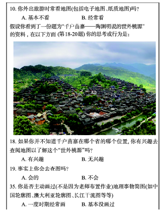
Spatial thinking ability is the basic ability of understanding geographical environment and a key geographic competence of students. Its influencing factors and mechanism need urgent attention for advancing spatial thinking theory. This study hypothesized that seven factors affect spatial thinking ability, including general intelligence level, living environment, interest in geography study, habit of using maps, interest in geographical problems, sensitivity about directions, and specialized geography knowledge. The level of spatial thinking ability and the seven hypothesized influencing factors of 126 samples from the Baiyin No.1 Middle School were measured by the spatial thinking ability test (STAT) measurement scales and factors’ measurement scales. The SPSS 23.0 software was used to analyze the related data. The samples were first divided into high, medium, and low score groups according to the level of spatial thinking ability, and general intelligence level, habit of using maps, and geography knowledge showed significant differences between the high and low score groups using independent sample T test. Then the samples were divided into high, medium, and low factor score groups, and general intelligence level, habit of using maps, specialized geography knowledge, and interest in geography study showed significant differences between the high and low factor score groups. The results indicate that general intelligence level, habit of using maps, and geography knowledge were necessary conditions of sample students’ high spatial thinking ability, and interest in geography study was also an important condition. The four factors were proven to be the main influencing factors of spatial thinking ability, and the level of influence from high to low was general intelligence, specialized geography knowledge, habit of using maps, and interest in geography study based on the result of the single factor linear regression analysis. The stepwise regression analysis result showed that general intelligence level and specialized geography knowledge had stronger influence on spatial thinking ability
Keywords:
人们总是生活在一个具体的地理环境之中,对环境空间有一个感应和认知的过程(顾朝林等, 2001)。人的环境空间认知可分为知觉、意象和抽象3个思维层次,其中空间知觉是对现实世界中地理现象真实的反映,它不仅包括依靠感官直接观察地理事物所获得的“心理图象(形象)”,而且还包括通过间接观察方法对地理非物质现象研究后所获得的知觉(鲁学军等, 1999)。间接观察方法是指较少依赖感性经验而较多地依赖人自身想象的地理学理解方法(Harvey, 1971)。空间意象则是一种介于感性认识和理性认识之间的“取象”,它与地理知觉映象的不同在于“象”和“意”的差别,是存在于人脑的地理事物的“意象”,具有非现实性和形象化的特征。随着地理意象对地理问题的现象、规律认识逐渐深入,空间意象对地理问题的模拟将会逐步接近事物的本质,最终影响地理概念模型的生成,并逐步进入空间抽象和理性思维层次(鲁学军等, 1999),没有这样的地理空间思维过程就没有人类对地理环境的认识和理解,这是人类生存与发展的基础。因此,人的空间认知(也可理解为地理空间思维)对于人类生存与发展有着重要意义,需要加以培养。基础教育阶段是培养人的地理空间思 维的最重要时期,而地理空间思维具有复杂而独特的发生机制和发展规律,在机制和规律被揭示之前,教育的努力可能是盲目和低效的;揭示发生机制和发展规律是教育界高效培养学生地理空间思维能力的理论基础,这也是本文立足的基点和研究目标。
近年来,国内外有2个研究领域同时从不同的角度开展地理空间思维研究。第一个领域是地理教育领域。研究者直接以地理空间思维为关键词,成果主要涉及地理空间思维的概念界定、能力测量、规律探索、培养策略等。在国内,徐志梅等(2013)研制的高中生地理空间能力量表是一项重要成果;徐志梅等(2011)发现,高中生地理空间思维能力存在男女差异、地区差异、年级差异,是对地理空间思维群体差异规律的揭示;一些研究成果还提出通过利用空间形状、空间大小、方位和距离等空间要素(袁孝亭, 2009)、利用心理地图(徐志梅等, 2012)及GIS(徐志梅等, 2010; 李屏, 2015)等方法发展学生空间思维的教学策略。在规律探索方面,地理空间思维能力影响因素、发生机制、发展规律等方面的实证研究则相对较少。目前一些成果提出,个体的形象思维和抽象思维能力、个体所积累的知识和已具有的空间概念、事物的时空特征(卢万合, 2005)、对地理学科的认识、思维的广度和深度(单华, 2013)等是地理空间思维发展的影响因素,出于其理论推演和经验总结的研究取向,以及研究内容及其方向选择的不同,这些因素对地理空间思维能力发展的影响及程度并未通过实证加以证实。国外地理教育领域研究者对地理空间思维能力的研究较为深入,主要集中在2个方面:一是空间思维能力测量工具的开发(Cohen et al, 2012; Lee et al, 2012)及其实践应用研究(Tomaszewski et al, 2015);二是地理空间思维能力的培养途径及其实际效果研究,包括利用虚拟空间软件(Hauptman, 2010)、动画和虚拟物体(Cohen et al, 2014)以及大量运用GIS(Lee et al, 2009; Cheung et al, 2011; Manson et al, 2014)促进地理空间思维能力提高的研究。以上成果均通过实证证实了学生的地理空间思维能力因此而得到提升,这种研究的思路是值得我们学习和借鉴的。
第二个领域是地理科学领域。研究者一般从空间认知(王茂军等, 2010)、认知地图(万刚等, 2008)、城市意象(Lynch, 1960; 鲁学军等, 1999; 顾朝林等, 2001)、空间行为(柴彦威, 2010; 周洁等, 2013)等行为地理学概念切入。虽然其研究的关键词往往不是地理空间思维,但其本质涉及人的空间思维,并提出了许多对地理空间认知(思维)有影响的因素,如Lynch(1960)提出城市结构中的通道、边缘、街区(区域)、节点和地标等;鲁学军等(1999)提出个体的文化特征、特殊的背景也会对人的空间认知产生影响;顾朝林等(2001)提出的影响因素有道路、地标、节点;冯健(2005)发现居住地域、性别、学历、收入以及出生地不同的居民的空间感知类型也不同;霍婷婷等(2009)发现,人的空间认知呈现出明显的空间相关性和尺度依赖性,反映了空间认知本身和空间尺度对空间认知的影响。此外,从王茂军等(2010)的实证研究中还可捕捉到城市环境的空间结构和居民的社会经济属性也是个体空间认知(思维)的影响因素;侯雪姣等(2014)还提出,人的性别、年龄、身份、区域生活时间、教育程度、收入水平、交通工具、职业等对人的空间认知有影响。这些从空间认知或城市意象等角度提出的影响因素(有些为属性特征)为人的地理空间思维发展研究提供了切入的角度,由于各因素对地理空间思维发展的作用机制和影响程度会有所不同,因此开展相关的实证研究对揭示规律、发展理论具有一定意义。
纵观国内外相关研究成果,可以发现,由于对地理空间思维能力的影响因素及其作用强度的定量研究相对不足,导致影响因素尚未得到普遍公认和充分证实。本文拟通过实证的方法发现地理空间思维能力的影响因素,并定量测度其对地理空间思维能力的作用强度,以利揭示地理空间思维的发生机制和发展规律,从而为高效培养学生的地理空间思维能力提供依据。
思维是人脑对客观事物本质属性与规律的概括和间接反映。本文的因变量是地理空间思维的发展水平(Y),思维的神经生理机制是大脑皮层的整体性活动。心理学认为,人的知觉特点、已有的经验、环境、适应、组织等是思维发展的影响因素(刘金花, 2006),因此在地理空间思维方面,空间知觉、空间认知经验、生活环境、空间适应和组织方式等会对地理空间思维产生影响。在此基础上,结合文献综述中述及的具体影响地理空间思维的因素,本文初步假设将一般智力水平(x1)、生活环境特征(x2)、地理学习兴趣(x3)、地图使用习惯(x4)、地理问题关注习惯(x5)、方向敏感程度(x6)、地理专业知识(x7)等7个具体的地理空间思维能力发展的影响因素用于实证检验。
运用美国地理学家协会(American Association of Geographers)提供的由Lee和Bednarz开发的地理空间思维能力测量量表(Lee et al, 2012)对样本的地理空间思维能力进行测量,运用国际标准智力测验量表对学生的一般智力进行测量,运用自主开发的生活环境特征、地理学习兴趣、地图使用习惯、地理问题关注习惯、方向敏感程度问卷进行各因素的测量(调查),再索取学生的2次重要地理考试(上学期期中、期末)成绩,作为其地理专业知识数据,并将所有数据标准化为0~1统一量纲。运用SPSS 23.0软件,对研究对象的地理空间思维能力和假设的7个影响因素进行相关分析;再将地理空间思维能力按水平高低分为高(前27%样本)、中、低(后27%样本)3个组,运用独立样本T检验的方法分析高低分组学生在各影响因素水平上的差异;将7个影响因素按其水平高低分为高、中、低3个组,运用独立样本T检验的方法分析各影响因素高低分组学生的地理空间思维能力差异;并对已经验证的影响因素进行回归分析,发现自变量对地理空间思维能力的影响程度,探索其作用强度和发生机制。
选取甘肃省白银市第一中学高一年级3个班 (1班、6班和13班)的学生作为样本进行测量和调查。样本学校是省级示范中学,高一年级共有14个班,抽样班级大致属于3个不同的层次,因此样本基本可代表高一学生总体。3个班级共有135名学生。调查测试卷回收率为100%。测谎未通过的样本有8份,另有1份回答不全,作为废卷,最终有效问卷126份,其中男生问卷54份,女生问卷72份,调查测试卷有效率为93.3%。
本文前后进行了2次数据采集。第一次数据采集时间为2016年2月29日,研究者亲自到场动员,并与任课教师配合实施地理空间思维能力测量和影响因素水平的调查,利用下午第3-4节课的时间集中进行,历时约70分钟。3月底向学校教务处索取了学生的考试成绩数据,处理后作为地理专业知识的数据。分析发现:一般智力水平、地理专业知识以及地图使用习惯与地理空间思维能力有较强的相关关系,于是对地图使用习惯因素的测题进行了扩充丰富(因原调查中仅有3道题),以提高其可靠性。并于2016年4月5日,由白银一中王军老师在上述3个班级主持数据重新采集工作。地图使用习惯的数据最终采用第二次采集的数据。
由于空间思维概念广泛应用于学术和非学术领域,所以其定义存在很多版本,相互间分歧也很突出,表现在尺度和维度、认知过程的本质、空间思维能力的组成成分以及空间能力和空间思维等概念的关系等方面(Lee et al, 2012)。徐志梅等(2013)使用“地理空间能力”概念,将其分为地理空间知觉能力、地理空间思维能力、地理空间想象能力3个方面,将地理空间思维能力作为地理空间能力的一个方面,并开发了地理空间能力测量量表。“地理空间认知”也是与地理空间思维相近的概念,Lloyd(1997)将其定义为人类理解地理空间,进行地理分析和决策的一系列心理过程。地理空间认知主要包括地理知觉、地理表象、地理概念化、地理知识的心理表征和地理空间推理等(王晓明等, 2005),这些都是人的地理空间思维活动。当前的学术研究成果中,“地理空间思维能力”没有公认的定义,但将其层次划分为知觉、想象(意象)、抽象则比较常见,如鲁学军等(1999)的成果中就是这样划分的。对于空间思维能力的测度,指标比较灵活,不同的群体有不同的测量指标(Ishikawa, 2013),取决于其价值取向及对地理空间思维能力的特定定义。本文旨在揭示地理空间思维的影响因素及其作用机制,未过多地深入研究地理空间思维的精确定义和层次结构,仅在Lee(2012)的地理空间思维能力测量(STAT)量表及其地理空间思维内涵的基础上进行研究。该量表由16道选择题组成,覆盖空间思维能力的8个方面,如表1所示。其所基于的地理空间思维内涵为:在空间感知基础上,运用空间想象(意象)进行空间分析和应用的思维能力。分析和应用是其对地理空间思维能力的主要测量取向,抽象和地理事物本质建模并非其主测的方向。量表编制者检验其有良好的信度(科隆巴赫信度系数为0.721)和较高的效度,量表在美国4个州(Lee et al, 2012)和非洲卢旺达(Tomaszewski et al, 2015)进行过测量及实践应用。该量表由我们翻译成中文版,对过程中情境和表述略做适应性修改,并在江苏省扬州、南京等地高中试测检验,证实其信度和效度达到良好水准,之后再在白银一中正式使用,实测数据显示量表信度为0.619,达到可接受的水平。
表1 空间思维能力测试所对应的8种空间思维组成成分
Tab.1 Eight spatial thinking ability components of the spatial thinking ability test
| 空间思维的组成成分 | 对应题号 |
|---|---|
| (1) 对方向的理解 | 1、2 |
| (2) 对地图信息的比较 | 3 |
| (3) 根据空间要素选择最佳位置 | 4 |
| (4) 根据地形图想象剖面图 | 5 |
| (5) 寻找空间相关性 | 6、7 |
| (6) 根据二维信息想象三维图象 | 8 |
| (7) 图层的覆盖和叠加 | 9、10、11、12 |
| (8) 理解地理事物的表达 | 13、14、15、16 |
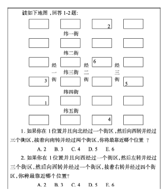
以下题例(图1)是STAT中的第1题和第2题,属于第一组成成分(对方向的理解)的测量。
3.2.1 一般智力水平测量
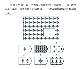
智力是人的综合性的心理能力,是以个体本身所具有的遗传条件为基础,并在其生活环境中不断学习和累积经验而形成的适应环境、解决问题的能力(张厚粲等, 2012)。本文通过国际标准智力测验获取一般智力水平的数据。该测验由39道题目组成,顺序由易到难,测题通过幻灯片展示,对不同难度的测题设定不同的展示停留时间,其中1-4题每题8秒,5-13题每题15秒,14-21题每题25秒,22-34题每题45秒,35-39题每题50秒,测量总计用时约20分钟。每题答对得1分,答错得0分,满分为39分,统计分析时将0~39分标准化为0~1。实测时量表信度为0.741,信度较好。测题示例如图2。
图2 国际标准智力测试题示例
Fig.2 An example of the international standard intelligence test question
3.2.2 地理专业知识测量
地理专业知识因素是指学生所具有的地理学科专业知识,其知识掌握水平可以通过地理专业知识测量获得。在第一次数据采集时,设置了9道地理专业知识的测验题,力求反映学生的地理主干知识和地理核心素养,但由于其信度较低,科隆巴赫信度系数仅为0.500,所以决定采用学生的重要地理考试成绩数据代替地理专业知识数据。于是在3月底向白银一中教务处索取了上述3个班级学生的高一上学期期中、期末地理考试成绩数据(根据试卷分析报告知2次考试的地理试题信度均为0.79),并按等权重方法加权为综合分值,统计分析时将0~100分标准化为0~1。
3.2.3 其他5项影响因素水平测量
其他5项假设的影响因素分别为生活环境特征、地理学习兴趣、地图使用习惯、地理问题关注习惯和方向敏感程度。生活环境特征主要指道路、建筑、设施的复杂程度;地理学习兴趣是学生力求认识和探究地理知识的心理倾向;地图使用习惯是由地图使用频次、方法、效率构成的指标;地理问题关注习惯是对地理问题关注的意识;方向敏感度指的是学生的方向感和方向意识。第一次测量时共设置了16道调查题。其中第12题用于调查研究对象常住的城乡位置(按102个城市学生和24个乡村学生分组进行独立样本T检验后发现两组学生的地理空间思维能力没有显著差异,P值为0.826,因此不再对其进行叙述),其他15道题为量表属性调查题,以李克特五分量表法计分,正向题按照“非常符合实际”、“较符合实际”、“一般”、“不太符合实际”、“很不符合实际”分别计为5、4、3、2、1分,负向题则计为1、2、3、4、5分。具体各影响因素对应的调查题目如表2所示。对属于同一影响因素的题目得分求平均值,得到该影响因素的水平,统计分析时将0~5分标准化为0~1。
表2 各假设影响因素所对应的调查题目
Tab. 2 Survey questions of the hypothesized influencing factors
| 假设影响因素 | 题号 |
|---|---|
| 生活环境特征 | 1、13、14、15、16 |
| 地理学习兴趣 | 2、11 |
| 地图使用习惯 | 3、4、5 |
| 地理问题关注习惯 | 6 |
| 方向敏感程度 | 7、8、9、10 |
在数据分析过程中发现,上述5个假设因素中仅地图使用习惯与地理空间思维能力有显著相关性,其他假设因素与地理空间思维的相关性并未达到显著性水平。分析认为可能不存在相关关系,或有其他原因很难验证其相关关系,但不排除一种可能,即所开发的测量工具(调查问卷)题量较少或质量存在问题,导致信度不佳。为提高问卷可靠性,项目组针对有较强相关关系的地图使用习惯重新设计了49道题的问卷,并在扬州、南京等地试测完善,删除6道题后最终变为43道调查题,在达到较高的信度和效度水平后在白银一中进行测试。实测后对所有题目与总分进行了相关分析,以发现影响信度的区分度不高的调查题,分析后删除9、20、30、36题,问卷信度由0.855提高到0.866。最终分析所用的地图使用习惯数据是根据余下的39道测题所测的数据。地图使用习惯的测题示例如图3所示。
采用皮尔逊相关分析法研究地理空间思维能力与各影响因素之间的相关性,分析结果如表3所示,地理空间思维能力与一般智力水平、地理专业知识、地图使用习惯的P值均小于0.05,说明一般智力水平、地理专业知识、地图使用习惯三个因素与地理空间思维能力具有极其显著或显著的相关性,其他因素暂未发现与地理空间思维能力有显著的相关性。
表3 地理空间思维能力与各影响因素的相关分析结果
Tab.3 Results of correlation analysis between spatial thinking ability and influencing factors
| 假设影响因素 | 地理空间思维能力 | ||
|---|---|---|---|
| 相关系数 | P值 | 显著性 | |
| 一般智力水平 | 0.480** | 0.000 | 极其显著 |
| 生活环境特征 | 0.005 | 0.959 | 不显著 |
| 地理学习兴趣 | 0.163 | 0.068 | 不显著 |
| 地图使用习惯 | 0.198* | 0.026 | 显著 |
| 地理问题关注习惯 | 0.120 | 0.182 | 不显著 |
| 方向敏感程度 | 0.036 | 0.690 | 不显著 |
| 地理专业知识 | 0.438** | 0.000 | 极其显著 |
将地理空间思维能力有差异的学生分组,用独立样本T检验方法检验其影响因素是否有差异。由于样本量大于100,在进行独立样本T检验时,可用总样本的27%来划分出地理空间思维能力水平的高低分组,即前27%为高分组,后27%为低分组,各有34个样本,分析结果如表4所示。地理空间思维能力高低分组学生间的一般智力水平、地理专业知识、地图使用习惯均存在极其显著的差异(P值<0.01),说明这3个因素是地理空间思维发展的必要条件,根据上文的理论论述,可以认为这些因素和地理空间思维能力之间存在因果关系。地理空间思维能力高低分组学生间的其他因素水平没有表现出显著性差异(P>0. 05),暂未被证实为地理空间思维能力的影响因素。
表4 地理空间思维能力高低分组的各影响因素差异
Tab.4 Differences in factor scores between high and low score groups of spatial thinking ability
| 假设影响因素 | 假设因素平均值 | 均值差距 | T值 | P值 | 显著性 | |
|---|---|---|---|---|---|---|
| 地理空间思维高分组(N=34) | 地理空间思维低分组(N=34) | |||||
| 一般智力水平 | 0.676 | 0.523 | 0.153 | -5.947 | 0.000 | 极其显著 |
| 生活环境特征 | 0.612 | 0.600 | 0.012 | -0.417 | 0.678 | 不显著 |
| 地理学习兴趣 | 0.682 | 0.600 | 0.082 | -1.748 | 0.085 | 不显著 |
| 地图使用习惯 | 0.454 | 0.331 | 0.123 | -3.292 | 0.002 | 极其显著 |
| 地理问题关注习惯 | 0.571 | 0.524 | 0.047 | -0.787 | 0.434 | 不显著 |
| 方向敏感程度 | 0.588 | 0.551 | 0.036 | -0.837 | 0.405 | 不显著 |
| 地理专业知识 | 0.770 | 0.629 | 0.141 | -4.081 | 0.000 | 极其显著 |
为验证各假设影响因素的差异是否会导致地理空间思维水平的差异,将各假设影响因素的水平按照总样本的前27%分为高分组,后27%分为低分组,各有34个样本,分析影响因素高低分组之间的地理空间思维能力是否有显著性差异,分析结果如表5所示。一般智力水平、地理专业知识、地图使用习惯、地理学习兴趣的高低分组之间地理空间思维水平有极显著或显著差异,这些因素可视为地理空间思维发展的重要条件,根据上文的理论论述,同样可认为它们之间存在因果关系。
表5 各影响因素水平高低分组的地理空间思维能力差异
Tab.5 Differences in spatial thinking ability between high and low factor score groups
| 假设影响因素 | 地理空间思维平均值 | 均值差距 | T值 | P值 | 显著性 | |
|---|---|---|---|---|---|---|
| 假设影响因素高分组(N=34) | 假设影响因素低分组(N=34) | |||||
| 一般智力水平 | 0.768 | 0.539 | 0.229 | -6.428 | 0.000 | 极其显著 |
| 生活环境特征 | 0.684 | 0.717 | -0.033 | 0.871 | 0.387 | 不显著 |
| 地理学习兴趣 | 0.702 | 0.608 | 0.094 | -2.173 | 0.034 | 显著 |
| 地图使用习惯 | 0.715 | 0.623 | 0.092 | -2.231 | 0.030 | 显著 |
| 地理问题关注习惯 | 0.671 | 0.614 | 0.057 | -1.273 | 0.207 | 不显著 |
| 方向敏感程度 | 0.695 | 0.673 | 0.022 | -0.600 | 0.550 | 不显著 |
| 地理专业知识 | 0.743 | 0.526 | 0.217 | -5.965 | 0.000 | 极其显著 |
一般智力水平、地理专业知识、地图使用习惯是地理空间思维能力发展的必要条件,地理学习兴趣为重要条件,从理论上推断4个因素与地理空间思维能力具有因果关系。分别以这4个因素为自变量,以地理空间思维发展水平为因变量,进行单因素线性回归分析,结果如表6。系数越大的自变量表示对因变量的作用强度越大,4个因素对地理空间思维能力的作用强度由大到小依次为: 一般智力水平>地理专业知识>地图使用习惯>地理学习兴趣。在其他因素控制的情况下,一般智力水平、地理专业知识各提高1分,地理空间思维能力分别提高0.672分和0.512分;而地图使用习惯、地理学习兴趣各提高1分,地理空间思维能力分别仅提高0.214分和0.148分。另外,4个自变量对因变量的总解释率(R2)均较小,分别为23.0%、19.2%、3.9%、2.7%,这恰恰说明了地理空间思维能力的影响因素较多且影响机制复杂。一般智力水平、地理专业知识与地理空间思维能力的回归方程显著性程度较高(P=0.000<0.01),说明了一般智力水平和地理专业知识对地理空间思维的作用具有相对强的规律性,拟合度(R2)显示的预测性也相对较高;而地理学习兴趣虽然是地理空间思维能力的影响因素,但回归拟合优度不佳(R2=0.027),方程也不显著(P=0.068>0.05),说明其作用强度还较弱;地图使用习惯的情况介于两者之间。
表6 4个影响因素与地理空间思维的单因素线性回归分析结果
Tab.6 Univariate linear regression results between four factors and spatial thinking ability
| 影响因素 | 常量 | 系数 | R2 | F值 | P值 | 显著性 |
|---|---|---|---|---|---|---|
| 一般智力水平 | 0.259 | 0.672 | 0.230 | 37.065 | 0.000 | 极其显著 |
| 地理专业知识 | 0.299 | 0.512 | 0.192 | 29.404 | 0.000 | 极其显著 |
| 地图使用习惯 | 0.578 | 0.214 | 0.039 | 5.050 | 0.026 | 显著 |
| 地理学习兴趣 | 0.566 | 0.148 | 0.027 | 3.382 | 0.068 | 不显著 |
再以上述4个因素为自变量,地理空间思维发展水平为因变量进行多元逐步线性回归分析,结果如表7所示,结果仅保留一般智力水平和地理专业知识2个自变量,因此,可认为一般智力水平和地理专业知识是地理空间思维水平的重要影响因素和有效预测指标。其回归方程为:
式中:Y表示地理空间思维水平,x1表示一般智力水平,x2表示地理专业知识。该回归模型的R2为0.308,即这2个自变量对因变量的总解释率为30.8%;方程显著性程度较高,P值为0.000。
表7 4个影响因素与地理空间思维能力的逐步回归分析结果
Tab.7 Stepwise regression analysis results of four factors and spatial thinking ability
| 影响因素 | 标准系数 | 非标准化系数 | 标准误差 | T值 | P值 | 显著性 |
|---|---|---|---|---|---|---|
| 常量 | 0.101 | 0.077 | 1.311 | 0.192 | ||
| 一般智力水平 | 0.368 | 0.516 | 0.113 | 4.558 | 0.000 | 极其显著 |
| 地理专业知识 | 0.301 | 0.353 | 0.094 | 3.733 | 0.000 | 极其显著 |
将学生按照性别分为男女两组,其中男生有54个样本,女生有72个样本,男生地理空间思维水平均值为0.676,女生为0.659,两样本方差齐性,采用独立样本T检验,T值为0.563,P值为0.574>0.05,如表8。显示未发现男女生在地理空间思维水平上有显著差异。同样,采用独立样本T检验来分析男女生之间在各影响因素水平上是否具有显著性差异,分析结果同样显示,地理空间思维的7个假设影响因素在男女生之间均未表现出显著性差异,说明上述规律具有性别普适性。
表8 地理空间思维能力和各影响因素的男女差异
Tab.8 Difference between spatial thinking ability and factor scores of male and female students
| 平均值 | 均值差距 | T值 | P值 | 显著性 | ||
|---|---|---|---|---|---|---|
| 男生(N=54) | 女生(N=72) | |||||
| 地理空间思维 | 0.676 | 0.659 | 0.017 | 0.563 | 0.574 | 不显著 |
| 一般智力水平 | 0.588 | 0.617 | -0.029 | -1.305 | 0.195 | 不显著 |
| 生活环境特征 | 0.607 | 0.593 | 0.014 | 0.786 | 0.433 | 不显著 |
| 地理学习兴趣 | 0.681 | 0.671 | 0.010 | 0.333 | 0.740 | 不显著 |
| 地图使用习惯 | 0.432 | 0.401 | 0.031 | 1.097 | 0.275 | 不显著 |
| 地理问题关注习惯 | 0.596 | 0.561 | 0.035 | 0.820 | 0.414 | 不显著 |
| 方向敏感程度 | 0.584 | 0.566 | 0.182 | 0.536 | 0.593 | 不显著 |
| 地理专业知识 | 0.733 | 0.704 | 0.029 | 1.129 | 0.261 | 不显著 |
(1) 一般智力水平、地理专业知识、地图使用习惯、地理学习兴趣是学生地理空间思维能力提高的影响因素,其对地理空间思维能力的作用强度由大到小依次为:一般智力水平>地理专业知识>地图使用习惯>地理学习兴趣,其中一般智力水平和地理专业知识可认为是地理空间思维水平的重要影响因素,并可依据由这2个自变量构建的回归方程相对准确地预测个体的地理空间思维发展水平。
对此结论解释和讨论如下:一般智力是人积累经验、适应环境、解决问题的综合性心理能力,它为各种特殊智力的形成和发展奠定了基础,与特殊智力互为因果关系。在各影响因素中,一般智力对地理空间思维能力形成的作用强度最明显,是地理空间思维形成的一种“创造”“软”实力;地理专业知识是地理空间思维形成的知识基础,是地理空间思维形成的“技术”“硬”实力;通过地图使用习惯形成的地理实景空间则据“有米之炊”中“米”的地位,是地理空间思维形成的“物质”“实体”,如能与个体的地理空间思维的创造智能和技术基础这两个软硬要素完美结合,再加上个体具有一定的地理学习兴趣、良好的地图使用习惯,其地理空间思维能力就能得到很好的发展。这是在分析基础上对地理空间思维发生机制和发展规律的解读。
(2) 地理空间思维能力高低分组间的一般智力水平、地理专业知识和地图使用习惯3个因素有显著性差异。一般智力水平、地理专业知识、地图使用习惯和地理学习兴趣高低分组间的地理空间思维能力有显著性差异。可见,地理学习兴趣可以促进地理空间思维能力的发展,但空间思维能力的发展不一定需要求助于地理学习兴趣。
地理学习兴趣高促使地理空间思维能力强,可据此推断地理学习兴趣是地理空间思维能力的影响因素之一,但地理空间思维能力强未必源于地理学习兴趣高,说明地理空间思维能力又受其他因素如一般智力水平、地理专业知识和地图使用习惯作用。换言之,对地理学习没有兴趣的人空间思维能力也可能因为其他因素而很强,但对地理学习感兴趣的人总体上比不感兴趣的人有较高的地理空间思维水平。
(3) 研究未发现地理空间思维水平以及影响因素在男女生之间有显著性差异。空间认知(思维)能力的性别差异是学术界关注的焦点之一(王茂军等, 2007)。赵叶珠等(1993)发现男女大学生在空间思维上表现出的差异不具有显著性;王启军(2008)发现初中男女生在空间知觉能力和空间定位能力方面不存在明显的差异(只在涉及空间心理旋转的空间想象能力方面存在着明显的差异);Golledge等(1995)和Kitchin(1996)的研究均认为空间认知能力没有性别差异。但仍有许多研究认为学生的地理空间思维能力有男女性别差异(许燕等, 2000; 徐志梅等, 2011; 周加仙等, 2013),如许燕等(2000)发现小学生在空间能力的发展趋势和空间组合能力方面,女生表现出稳定的优势;在空间旋转能力上,男生的优势随年龄增长表现为减弱并消失的特征。本文未发现高中生地理空间思维能力有显著性别差异仅源于白银一中的案例,还需要有更多案例、更大样本的研究。
在教育实践方面,地理空间思维能力的提高受一般智力水平、地理专业知识、地图使用习惯和学习兴趣的影响,而一般智力水平很难迅速提高,地理专业知识的掌握已是地理教学始终在努力的目标,兴趣短时间内很难变化,而地图使用习惯则是一个目前容易忽略但又可以训练提高的因素,重视这一因素,可能会在一定程度上较快地提高地理空间思维能力;而且在智力水平相近的学生群体中,地图使用习惯的出色可能是其空间思维能力超出群体其他同学的原因,不妨进行一些尝试或实验。
在一般智力水平、地理专业知识为自变量的地理空间思维能力模型下识别地理空间思维能力水平发展正常、超常和失常的学生,对超常和失常的学生进行具体分析,发现其发展经验和制约因素,用于促进发展、保持超常、预防失常;在经验总结和寻找制约因素过程中,发现或寻觅更多对地理空间思维能力提高起作用的因素,为进一步的影响因素、发生机制和发展规律研究提供灵感。
(1) 在后续研究方面,如果以上4个因素影响地理空间思维能力提高是一条普遍规律,则其应能在其他样本群体中得到重复验证。如果大多数案例能验证这一结论,则可在更可信的程度上将其归纳为一般规律。但鉴于地理空间思维能力提高的影响因素众多、机制复杂,且影响相互交叉和干扰,确认规律的任务仍十分艰巨。期待今后有更多自然状态或控制实验的数据来进一步对上述结论进行验证,为最终揭示地理空间思维能力发展的科学规律作出努力。
(2) 在量表信度方面,本文中对地理空间思维能力的5个假设影响因素进行的第一次测量工作因测题数量少,信度效度低,可能是一些假设因素未能得到证实的原因。今后需要进一步开发具有更高信度和效度的影响因素测量量表(问卷),以发现更多的地理空间思维能力提高的影响因素。
(3) 在研究方法方面,自变量与地理空间思维能力之间虽然可能有相关(或因果)关系,但受其他多种因素影响,一些因素与地理空间思维能力的回归方程显著性低,用回归方法揭示规律往往困难,而运用独立样本T检验或基于实验进行配对样本T检验的方法可能更为合适,这有待进一步探讨。
The authors have declared that no competing interests exist.
| [1] |
|
| [2] |
北京城市居民的空间感知与意象空间结构 [J].https://doi.org/10.3969/j.issn.1000-0690.2005.02.003 URL 摘要
The author selects 10 districts of Beijing and try to investigate the cognitive maps of urban residents in Beijing by questionnaire.He get 323 cognitive maps, which are classified and counted, and as a result, correlative statistical data are obtained.Based on the above-mentioned work, the author analyzs the basic types, constitutive factors, development phases and the characteristics of differences of cognitive maps of urban residents in Beijing.The research shows that although the types of spatial cognition of Beijing’s residents are similar to those of the western cities of China, they are a little different.The grades of cognitive maps are concerned with residential area, sex, educational level, income and birthplace of urban residents.The constitutive factors of cognitive maps are concerned with residential area, age, income and birthplace of urban residents, while the development phrases are concerned with sex, income and birthplace of urban residents in Beijing.The research also shows that social role and economic income level play important roles in the development phrases of spatial cognition of Beijing’s urban residents.At last, the author generalizes the spatial structure of Beijing’s urban image based on the location and frequency of elements recorded on the cognitive maps of urban residents, and find that it is similar to the emphases of spatial distribution of Beijing.As a result, some theories of urban image of Lynch are proved in Beijing.
Spatial cognition and the image space of Beijing's residents [J].https://doi.org/10.3969/j.issn.1000-0690.2005.02.003 URL 摘要
The author selects 10 districts of Beijing and try to investigate the cognitive maps of urban residents in Beijing by questionnaire.He get 323 cognitive maps, which are classified and counted, and as a result, correlative statistical data are obtained.Based on the above-mentioned work, the author analyzs the basic types, constitutive factors, development phases and the characteristics of differences of cognitive maps of urban residents in Beijing.The research shows that although the types of spatial cognition of Beijing’s residents are similar to those of the western cities of China, they are a little different.The grades of cognitive maps are concerned with residential area, sex, educational level, income and birthplace of urban residents.The constitutive factors of cognitive maps are concerned with residential area, age, income and birthplace of urban residents, while the development phrases are concerned with sex, income and birthplace of urban residents in Beijing.The research also shows that social role and economic income level play important roles in the development phrases of spatial cognition of Beijing’s urban residents.At last, the author generalizes the spatial structure of Beijing’s urban image based on the location and frequency of elements recorded on the cognitive maps of urban residents, and find that it is similar to the emphases of spatial distribution of Beijing.As a result, some theories of urban image of Lynch are proved in Beijing.
|
| [3] |
北京城市意象空间及构成要素研究 [J].Urban image space and main factors in Beijing [J]. |
| [4] |
南京城市意象空间及其影响因素分析 [J].https://doi.org/10.3969/j.issn.1000-0952.2014.16.014 URL 摘要
城市化快速发展背景下,城市意象的研究有助于城市特色的加强和城市竞争力的提高。以南京都市 圈为研究对象,采用问卷调查搜集数据,通过ArcGIS和SPSS进行数据处理,分析南京城市意象空间布局及意象水平的影响要素。南京城市意象要素主要集 中在主城区范围内,随着交通的便利,主城区以外的意象水平也有一定的提高,但由于长江的阻隔,江北仍为意象缺失区域。被调查者的性别、年龄、身份、生活时 间、教育程度、收入水平、交通工具、职业对南京城市总体意象或某个要素意象水平具有显著影响,而居住地一向要素均没有显著影响。
Nanjing chengshi yixiang jiqi yingxiang yinsu fenxi [J].https://doi.org/10.3969/j.issn.1000-0952.2014.16.014 URL 摘要
城市化快速发展背景下,城市意象的研究有助于城市特色的加强和城市竞争力的提高。以南京都市 圈为研究对象,采用问卷调查搜集数据,通过ArcGIS和SPSS进行数据处理,分析南京城市意象空间布局及意象水平的影响要素。南京城市意象要素主要集 中在主城区范围内,随着交通的便利,主城区以外的意象水平也有一定的提高,但由于长江的阻隔,江北仍为意象缺失区域。被调查者的性别、年龄、身份、生活时 间、教育程度、收入水平、交通工具、职业对南京城市总体意象或某个要素意象水平具有显著影响,而居住地一向要素均没有显著影响。
|
| [5] |
基于地名认知率的北京城市认知空间结构 [J].https://doi.org/10.11820/dlkxjz.2009.04.006 URL Magsci 摘要
<p>基于对北京市居民空间认知的3500份调查问卷数据,采用了ARCGIS的空间插值和Geoda095i软件的空间自相关的数理统计方法,分析北京市居民的认知空间结构。研究得到四点结论:①认知地点的类型并不是影响认知率的因素。②居民对北京市的空间认知呈现出西高东低的“>”形格局,在西北—东南方向隆起动物园和北京火车站两个认知高峰,鞍部为低认知率的东方新天地和sogo崇光百货。③居民认知呈现明显的空间相关性和尺度依赖性。地名认知在较小的空间尺度上为高—高、低—低集聚的趋同性,在较大的空间尺度上表现为高-低集聚的趋异性,两者的转换尺度为城市居民日常生活空间的半径6 km左右。④北京城市的认知空间可细分为北海公园、中友百货、动物园和城乡贸易中心四个次级认知区域,次级认知区域为同质的高认知区,内部包含多个认知高峰。</p>
An analysis of spatial cognitive structure in Beijing City based on the cognitive rate of place names [J].https://doi.org/10.11820/dlkxjz.2009.04.006 URL Magsci 摘要
<p>基于对北京市居民空间认知的3500份调查问卷数据,采用了ARCGIS的空间插值和Geoda095i软件的空间自相关的数理统计方法,分析北京市居民的认知空间结构。研究得到四点结论:①认知地点的类型并不是影响认知率的因素。②居民对北京市的空间认知呈现出西高东低的“>”形格局,在西北—东南方向隆起动物园和北京火车站两个认知高峰,鞍部为低认知率的东方新天地和sogo崇光百货。③居民认知呈现明显的空间相关性和尺度依赖性。地名认知在较小的空间尺度上为高—高、低—低集聚的趋同性,在较大的空间尺度上表现为高-低集聚的趋异性,两者的转换尺度为城市居民日常生活空间的半径6 km左右。④北京城市的认知空间可细分为北海公园、中友百货、动物园和城乡贸易中心四个次级认知区域,次级认知区域为同质的高认知区,内部包含多个认知高峰。</p>
|
| [6] |
GIS在中学生地理空间思维能力培养中的应用[D] . |
| [7] |
|
| [8] |
中学生地理空间思维能力及其培养[D] . |
| [9] |
论地理空间形象思维: 空间意象的发展 [J].https://doi.org/10.3321/j.issn:0375-5444.1999.05.003 URL [本文引用: 3] 摘要
As carriers of geographic thinking and a kind of spatial thinking mode in images, Spatial Mental Images (SMIs) act as a ridge between the geographic physical world and the geographic conceptual computational model, providing a method for representing the geographic information and knowledge in images. With a stereoscopic effect on the mind and feeling, SMIs possess self learning capability. Although being born of the geographic perception experiences, SMIs create a much greater effect on the spatial thinking than the geographic perception experiences do. It is just SMIs that extricate geographers from pure sense perception world, and make their geographic thinking consist of two parts: descriptive thinking and thinking in images. Reviewing the development of geographic thinking, SMIs can be divided into four types: geographic region, geographic complex, geographic landscape and regional geographic system. The thinking method, implication and essence of the four kinds of SMIs have been discussed in the article. Though discussions of the development of SMIs, the spatial process research method of geographic landscape and the regional geographic system are expounded. The former embodies the essence of the geographic method research; and the latter, wh surface layer. As a fundamental function cell of regional analysis, geographic landscape is a structural component for building and realizing a regional geographic system. When one geographic landscape being demonstrated, invariable basic cells of geographic region analysis can be applied. As unification of possessing invariable corresponding relationship between space and process, the invariable basic cells are the least unit of spatial function. In order to really and truly establish the geographic analysis oriented data model for geographic information systems (GIS), it is suggested to build Integrated Data Model of Geographic Landscape regarding the invariable basic cells as fundamental cells of organizing geographic information, and to build Distributed Net Model of Geographic Region based on network analysis of regional energy flow in which landscapes are functional nodes.
On geographic spatial thinking in images: The development of spatial mental images [J].https://doi.org/10.3321/j.issn:0375-5444.1999.05.003 URL [本文引用: 3] 摘要
As carriers of geographic thinking and a kind of spatial thinking mode in images, Spatial Mental Images (SMIs) act as a ridge between the geographic physical world and the geographic conceptual computational model, providing a method for representing the geographic information and knowledge in images. With a stereoscopic effect on the mind and feeling, SMIs possess self learning capability. Although being born of the geographic perception experiences, SMIs create a much greater effect on the spatial thinking than the geographic perception experiences do. It is just SMIs that extricate geographers from pure sense perception world, and make their geographic thinking consist of two parts: descriptive thinking and thinking in images. Reviewing the development of geographic thinking, SMIs can be divided into four types: geographic region, geographic complex, geographic landscape and regional geographic system. The thinking method, implication and essence of the four kinds of SMIs have been discussed in the article. Though discussions of the development of SMIs, the spatial process research method of geographic landscape and the regional geographic system are expounded. The former embodies the essence of the geographic method research; and the latter, wh surface layer. As a fundamental function cell of regional analysis, geographic landscape is a structural component for building and realizing a regional geographic system. When one geographic landscape being demonstrated, invariable basic cells of geographic region analysis can be applied. As unification of possessing invariable corresponding relationship between space and process, the invariable basic cells are the least unit of spatial function. In order to really and truly establish the geographic analysis oriented data model for geographic information systems (GIS), it is suggested to build Integrated Data Model of Geographic Landscape regarding the invariable basic cells as fundamental cells of organizing geographic information, and to build Distributed Net Model of Geographic Region based on network analysis of regional energy flow in which landscapes are functional nodes.
|
| [10] |
高中地理学科能力培养的研究[D] . |
| [11] |
基于阅读实验方法的认知地图形成研究 [J].https://doi.org/10.3321/j.issn:1007-4619.2008.02.021 URL Magsci [本文引用: 1] 摘要
地图空间认知理论是地图学的基础理论,其基本命题是"地图是人类空间认知工具",核心概念是认知地图.对认知地图的形成进行了全面的总结,给出了地图空间认知的过程框架,进行了基于纸质地图、电子地图、遥感影像和虚拟地理环境阅读的认知实验.论文认为基于阅读行为的认知地图形成过程是从整体到局部的,这和基于亲历的过程是不同的;在基于阅读行为建立对环境的空间认知过程中,大比例尺和小比例尺是存在差异的;基于阅读的认知草图基本上属于"空间型"草图,以区位导向为主;四种不同的认知手段所造成的空间认知结果也是不同的.
Research of cognitive map formation based on reading experiments [J].https://doi.org/10.3321/j.issn:1007-4619.2008.02.021 URL Magsci [本文引用: 1] 摘要
地图空间认知理论是地图学的基础理论,其基本命题是"地图是人类空间认知工具",核心概念是认知地图.对认知地图的形成进行了全面的总结,给出了地图空间认知的过程框架,进行了基于纸质地图、电子地图、遥感影像和虚拟地理环境阅读的认知实验.论文认为基于阅读行为的认知地图形成过程是从整体到局部的,这和基于亲历的过程是不同的;在基于阅读行为建立对环境的空间认知过程中,大比例尺和小比例尺是存在差异的;基于阅读的认知草图基本上属于"空间型"草图,以区位导向为主;四种不同的认知手段所造成的空间认知结果也是不同的.
|
| [12] |
认知地图空间分析的地理学研究进展 [J].The progress of geographical study on the spatial analysis of cognitive map [J]. |
| [13] |
北京城市空间认知扭曲特征 [J].https://doi.org/10.11820/dlkxjz.2010.10.005 URL Magsci [本文引用: 1] 摘要
<p>通过BR方法和标准方差椭圆的方法,解析了北京城市居民的空间认知扭曲,着重讨论了系统扭曲和系统扭曲的特点。分析发现:①北京城市空间认知的绝对扭曲结构表现为顺时针向心集聚,呈现出磁石效应,城市中心区明显小于城市郊区的差异可以用报酬假说中的城市中心吸引力较高解释。其中,绘图提示中的天安门发挥着组织北京城市认知空间的核心效能。②北京城市空间的系统扭曲较小,规则的环状路网发挥着城市居民空间认知基准线的作用,导致了高相似拓扑结构,小方向偏转的扭曲效果,折射出北京城市空间结构的鲜明特色。③具体到北京城市内各地点,位置认知差异性显著。集中性方面,郊区小于中心城区,远离环路地点小于环路及其附近地点;主导方向方面,郊区较中心城区明显,提示环路较非环路地点明显。</p>
The characteristics of urban spatial cognitive distortion in Beijing [J].https://doi.org/10.11820/dlkxjz.2010.10.005 URL Magsci [本文引用: 1] 摘要
<p>通过BR方法和标准方差椭圆的方法,解析了北京城市居民的空间认知扭曲,着重讨论了系统扭曲和系统扭曲的特点。分析发现:①北京城市空间认知的绝对扭曲结构表现为顺时针向心集聚,呈现出磁石效应,城市中心区明显小于城市郊区的差异可以用报酬假说中的城市中心吸引力较高解释。其中,绘图提示中的天安门发挥着组织北京城市认知空间的核心效能。②北京城市空间的系统扭曲较小,规则的环状路网发挥着城市居民空间认知基准线的作用,导致了高相似拓扑结构,小方向偏转的扭曲效果,折射出北京城市空间结构的鲜明特色。③具体到北京城市内各地点,位置认知差异性显著。集中性方面,郊区小于中心城区,远离环路地点小于环路及其附近地点;主导方向方面,郊区较中心城区明显,提示环路较非环路地点明显。</p>
|
| [14] |
初中生地理空间能力的性别差异研究[D] .
|
| [15] |
地理空间认知综述 [J].Geo-spatial cognition: An overview [J]. |
| [16] |
运用GIS培养中学生地理空间能力 [J].Yunyong GIS peiyang zhongxuesheng dili kongjian nengli [J]. |
| [17] |
高中生地理空间能力水平差异研究 [J].Gaozhongsheng dili kongjian nengli shuiping chayi yanjiu [J]. |
| [18] |
运用心理地图培养学生地理空间能力 [J].Yunyong xinli ditu peiyang xuesheng dili kongjian nengli [J]. |
| [19] |
高中生地理空间能力测量量表初步编制 [J].https://doi.org/10.3969/j.issn.1671-0916.2013.08.040 URL 摘要
地理空间能力对学生的学习具有 基础性作用。由于目前没有完整的适合高中生地理空间能力测量的工具,所以发展高中生的地理空间能力测量工具就显得尤为重要。笔者在构建高中生地理空间能力 指标项目的基础上,初步编制了地理空间能力测量量表,并对量表进行了项目研究及信度、效度考验。
Gaozhongsheng dili kongjian nengli celiang liangbiao chubu bianzhi [J].https://doi.org/10.3969/j.issn.1671-0916.2013.08.040 URL 摘要
地理空间能力对学生的学习具有 基础性作用。由于目前没有完整的适合高中生地理空间能力测量的工具,所以发展高中生的地理空间能力测量工具就显得尤为重要。笔者在构建高中生地理空间能力 指标项目的基础上,初步编制了地理空间能力测量量表,并对量表进行了项目研究及信度、效度考验。
|
| [20] |
小学生空间能力及其发展倾向的性别差异研究 [J].Primary school pupils' gender differences in special abilities [J]. |
| [21] |
利用地理空间要素发展学生空间思维 [J].Developing students' spatial thinking by using geo-spatial elements [J]. |
| [22] |
|
| [23] |
大学生空间思惟的性别差异研究 [J].A study of sex differences in college-students' spatial thinking [J]. |
| [24] |
中国老年人空间行为研究进展 [J].https://doi.org/10.11820/dlkxjz.2013.05.004 URL Magsci [本文引用: 1] 摘要
中国人口老龄化及空巢化现象的加快使得老龄问题受到学者关注.老龄化进程和养老模式等宏观层面的研究为中国老龄工作的开展提供政策指导,而政策的落实状况及其对老年人生活的影响需要从微观层面通过空间行为分析来还原老年人个体与环境之间的互动关系.本文从空间行为的视角对国内多个学科的老年人日常行为相关研究进行评述.基于对老年人生活方式及需求层次理论的认知,文章聚焦中国老年人日常生活的主体行为:就医行为、购物行为和休闲行为,梳理这3 类行为的国内研究发展历程及其行为特征、影响机制分析等主要研究结论.基于时空间尺度和出行链进行了中国老年人空间行为研究的地理学探讨,并结合国际老年地理学的研究发展,提出了老年人空间行为研究的展望.
Research progress on spatial behaviors of the elderly in China [J].https://doi.org/10.11820/dlkxjz.2013.05.004 URL Magsci [本文引用: 1] 摘要
中国人口老龄化及空巢化现象的加快使得老龄问题受到学者关注.老龄化进程和养老模式等宏观层面的研究为中国老龄工作的开展提供政策指导,而政策的落实状况及其对老年人生活的影响需要从微观层面通过空间行为分析来还原老年人个体与环境之间的互动关系.本文从空间行为的视角对国内多个学科的老年人日常行为相关研究进行评述.基于对老年人生活方式及需求层次理论的认知,文章聚焦中国老年人日常生活的主体行为:就医行为、购物行为和休闲行为,梳理这3 类行为的国内研究发展历程及其行为特征、影响机制分析等主要研究结论.基于时空间尺度和出行链进行了中国老年人空间行为研究的地理学探讨,并结合国际老年地理学的研究发展,提出了老年人空间行为研究的展望.
|
| [25] |
空间思维能力的认知机制及其对STEM教学的启示: 与美国Nora S. Newcombe院士的对话 [J].
空间思维能力对“科学、技术、工程和数学”学科的学习非常重要。虽然空间思维能力上存在性别差异,但是平均性别差异并不能说明个体表现的好坏。教育者更应关注空间思维能力的可塑性,利用手势、语言、类比推理等空间学习的有效工具,从多方面提高儿童的空间思维能力。
The cognitive mechanism of spatial thinking and its implications for STEM instruction: Interview with Prof. Nora S. Newcombe [J].
空间思维能力对“科学、技术、工程和数学”学科的学习非常重要。虽然空间思维能力上存在性别差异,但是平均性别差异并不能说明个体表现的好坏。教育者更应关注空间思维能力的可塑性,利用手势、语言、类比推理等空间学习的有效工具,从多方面提高儿童的空间思维能力。
|
| [26] |
Enable spatial thinking using GIS and satellite remote sensing: A teacher-friendly approach [J].https://doi.org/10.1016/j.sbspro.2011.07.014 URL [本文引用: 1] 摘要
The New Senior Secondary (NSS) curriculum has been implemented in Hong Kong since September, 2009. One major objective of this initiative is to help students acquire critical thinking, information technology and life-long learning skills through the Independent Enquiry Learning (IEL) approach. Geographical Information System (GIS) and Satellite Remote Sensing (RS) can be very effective tools for multiple subjects in the NSS curriculum, particularly in Geography and Liberal Studies. However, there exists a huge technical barrier for teachers to apply the technologies in the ordinary classrooms. Hence, this project, funded by the Quality Education Fund of the Hong Kong SAR Government, aims to support the teachers of Hong Kong using GIS and satellite remote sensing in their classrooms. The implementation approach is designed totally from a practitioner's perspective; hence, the fundamental brief of this project is to develop useful resources for teachers and the products shall be; 1.) Teachers and Students - Friendly; 2.) Encourage students to practice critical thinking and spatial thinking skills; 3.) Encourage students to apply knowledge / experience acquired through the learning activities to the other field of interests; 4.) Lowering the barrier of transforming teachers鈥 / students鈥 creativity to practical GIS / Remote Sensing projects and learning activities. Products of this project include a comprehensive resources pool of GIS Data and Remote Sensing Images; a teacher-friendly GIS and satellite image processing software; teachers鈥 training workshops and mostly important, school-based supports. This paper will highlight the first batch of achievements and products, evaluations, successful cases of classroom implementation as well as the feedback from the frontline teachers.
|
| [27] |
Inferring cross sections of 3D objects: A new spatial thinking test [J].https://doi.org/10.1016/j.lindif.2012.05.007 URL Magsci [本文引用: 1] 摘要
A new spatial ability test was administered online to 223 undergraduate students enrolled in introductory science courses. The 30-item multiple choice test measures individual differences in ability to identify the two-dimensional cross section of a three-dimensional geometric solid, a skill that has been identified as important in science, technology, engineering and mathematics (STEM) fields. Bivariate and partial correlations suggest that the test measures a skill that is distinct from three-dimensional mental rotation and change in view perspective. Test items varied along two scales: complexity of the geometric solid to be sliced and orientation of the cutting plane. Internal reliability of both the overall test and its subscales was satisfactory. Performance was higher on figures cut by orthogonal, rather than oblique, planes. Patterns of performance across more and less complex items, and patterns of sex differences on these items, suggest that items on the test are differentially amenable to imagistic and analytic strategies, with males outperforming females on items that are less amenable to analytic strategies. The test shows promise for online administration and for adaptation to younger populations. (C) 2012 Elsevier Inc. All rights reserved.
|
| [28] |
Visualizing cross sections: Training spatial thinking using interactive animations and virtual objects [J].https://doi.org/10.1016/j.lindif.2014.04.002 URL [本文引用: 1] 摘要
61Two experiments demonstrated the efficacy of a spatial training intervention.61Participants were undergraduates who were challenged by spatial thinking.61The novel protocol uses interactive animation and virtual objects.61Performance gains and limited transfer occurred after a brief training period.61Results are considered with respect to two accounts of improvement after training.
|
| [29] |
Acquiring spatial knowledge: Survey versus route-based knowledge in unfamiliar environments [J].https://doi.org/10.1111/j.1467-8306.1995.tb01798.x URL 摘要
An interesting controversy has recently arisen regarding the relative effectiveness of map-based versus route-based environmental learning. Although spatial theory suggests that map-based (survey) knowledge should be more effective, recent research shows some contrary results. In this paper we describe an experiment in which subjects learn either from a map or from a computer-simulated walk through an environment. Tests of route reproduction, cue location, orientation, and directional knowledge are undertaken. We are unable to show convincing statistical evidence of the superiority of map learning, although descriptive measures of performance on our tasks all pointed to map superiority. Some evidence is obtained that geographic training helps performance tasks. No differences based on sex could be statistically determined, although some evidence pointed to higher performance overall by geographically trained females. A final discussion focuses on the role that the configuration of features in the environment has on environmental learning.
|
| [30] |
Explanation in geography [M]. |
| [31] |
Enhancement of spatial thinking with Virtual Spaces 1.0 [J].https://doi.org/10.1016/j.compedu.2009.07.013 URL [本文引用: 1] 摘要
Developing a software environment to enhance 3D geometric proficiency demands the consideration of theoretical views of the learning process. Simultaneously, this effort requires taking into account the range of tools that technology offers, as well as their limitations. In this paper, we report on the design of Virtual Spaces 1.0 software, a program that exercises the user’s abilities to build spatial images and to manipulate them. This paper also reports on a study that aimed to assess whether those abilities affected achievements in the spatial thinking of 10th graders who worked with the software. Additionally, we investigated whether self-regulating questions can improve the effect of exercising with Virtual Spaces 1.0. The sample was 192 students, who were randomly assigned to four groups, two of which used Virtual Spaces 1.0 (Group 1 with virtual reality and self-regulating questions 02=0252, Group 2 with virtual realty only 02=0252) and the other two the non-Virtual Spaces 1.0 (Group 3 self-regulating questions only 02=0245, Group 4 non-treatment group 02=0245). The results suggest that spatial thinking was enhanced by exercising with Virtual Spaces 1.0 and asking self-regulating questions. In addition, it was found that the self-regulating questions make the use of virtual reality more efficient, and that the influence of self-regulating questions is especially manifested in tasks that make use of high order skills.
|
| [32] |
Geospatial thinking and spatial ability: An empirical examination of knowledge and reasoning in geographical science [J].https://doi.org/10.1080/00330124.2012.724350 URL [本文引用: 1] 摘要
This study examined the relationships between geospatial thinking and spatial ability, focusing on knowledge and reasoning about fundamental concepts in geospatial science. Scores on a geospatial thinking test had low correlations with each other, compared to high correlations among scores on spatial ability tests, and the degrees of relationship between geospatial thinking and spatial ability depended on the type of geospatial thinking. Expert geospatial scientists did not outperform students on spatial ability tests, suggesting that expertise in geospatial science might not simply be explained by superiority in spatial ability. The results point to the necessity of targeted instruction for geospatial learning.
|
| [33] |
Are there sex differences in geographic knowledge and understanding [J].https://doi.org/10.2307/3059650 URL 摘要
Research by both geographers and psychologists suggests that there are differences in females' and males' everyday geographic and spatial knowledge. These differences in knowledge have been attributed to variances in biology and hormonal levels; differences in social status, culture and education; and differences in the ability to answer questions and think about geographic space. This paper examines these theories and explores the everyday geographic knowledge of females and males using both quantitative exercises and qualitative interviews. In contrast to most studies, only a few minor differences were found between females' and males' knowledge, their ability to answer the questions set and the strategies of spatial thought employed and it is suggested that any differences found between the sexes in other studies are due to socio-cultural factors reinforcing gender stereotypes.
|
| [34] |
Effect of GIS learning on spatial thinking [J].https://doi.org/10.1080/03098260802276714 URL PMID: 14110195 [本文引用: 1] 摘要
A spatial-skills test is used to examine the effect of GIS learning on the spatial thinking ability of college students. Eighty students at a large state university completed pre- and post- spatial-skills tests administered during the 2003 fall semester. Analysis of changes in the students' test scores revealed that GIS learning helped students think spatially. These improvements were the result of the connection between students' GIS activities and experiences and the tested spatial thinking skills. Strong correlations were observed between the participants' spatial thinking and their achievement in the GIS course.
|
| [35] |
Components of spatial thinking: Evidence from a spatial thinking ability test [J].https://doi.org/10.1080/00221341.2011.583262 URL Magsci [本文引用: 4] 摘要
This article introduces the development and validation of the spatial thinking ability test (STAT). The STAT consists of sixteen multiple-choice questions of eight types. The STAT was validated by administering it to a sample of 532 junior high, high school, and university students. Factor analysis using principal components extraction was applied to identify underlying spatial thinking components and to evaluate the construct validity of the STAT. Spatial components identified through factor analysis only partly coincided with spatial concepts used to develop the questions that compose the STAT and with the components of spatial thinking hypothesized by other researchers.
|
| [36] |
Spatial cognition: Geographic environments [M].
|
| [37] |
|
| [38] |
Resource needs and pedagogical value of web mapping for spatial thinking [J].https://doi.org/10.1080/00221341.2013.790915 URL Magsci [本文引用: 1] 摘要
Web mapping involves publishing and using maps via the Internet, and can range from presenting static maps to offering dynamic data querying and spatial analysis. Web mapping is seen as a promising way to support development of spatial thinking in the classroom but there are unanswered questions about how this promise plays out in reality. This article examines the resource demands and pedagogical value of Web mapping for geographical education for the case of an undergraduate introductory geography course designed to develop spatial thinking in students. Web mapping can be effective but is subject to a range of pedagogical, institutional, and technological caveats and corollaries.
|
| [39] |
Spatial thinking ability assessment in Rwandan secondary schools: Baseline results [J].https://doi.org/10.1080/00221341.2014.918165 URL [本文引用: 2] 摘要
This article discusses use and modification of Lee and Bednarz (2012) Spatial Thinking Ability Test (STAT) as a spatial thinking assessment device in Rwandan secondary schools. After piloting and modifying the STAT, 222 students total from our rural and urban test schools and one control school were tested. Statistical analysis revealed that urban test school students outperformed rural test school students and that males outperformed females. Also observed were significant differences in performance for particular STAT question categories that can be used to inform strategies for spatial thinking curricular development and further modifications to the STAT in other contexts.
|

/
| 〈 |
|
〉 |