

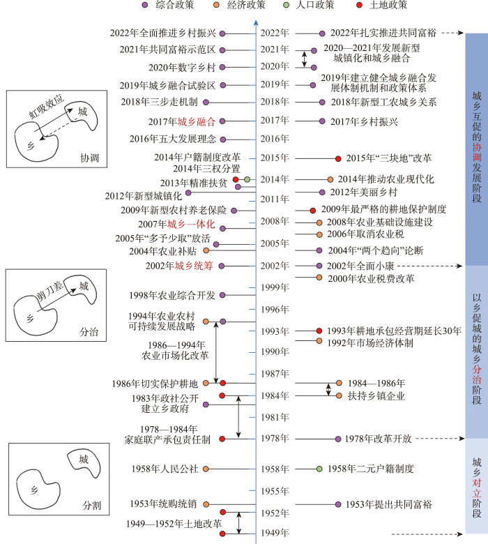
城乡融合本质上是城乡关系转型的一个阶段[1],指在城乡地域系统内,基于资源要素的自由流动与优化配置,推动城乡经济、人口、空间、社会和生态等多维融合,实现城乡居民生活质量和公共服务等值,从而形成城乡有机协调、功能互补、利益共享的复合系统[2⇓⇓-5]。梳理中国城乡关系及其政策演化发现(图1),1949年以来,人民公社、城乡二元户籍等政策使城乡生产要素流动受到严格限制,城乡对立关系逐渐形成,计划经济体制得以巩固。改革开放以来,以联产承包责任制和社会主义市场经济体制为基础,中国工业化和城镇化迅速推进,偏向城市的发展模式逐渐形成,农村剩余劳动力不断流入城市,支撑城市优先发展,造成城乡产品“剪刀差”,城市和农村之间的互反关系日益凸显[6],城乡差距不断扩大,城市环境污染、农村空心化、城乡土地配置失衡等问题已成常态[7],城乡处于“以乡促城”的分治阶段。21世纪以来,为破除不合理的城乡二元结构,中国相继构建了城乡统筹、城乡一体化和城乡融合等新型城乡关系目标定位,城乡交通网及信息网不断完善,城乡要素双向流动以及产业互动开始显现,城乡居民的收入消费差距逐步缩小,城乡公共服务及基础设施的不均衡配置得以改善,城乡步入协调发展阶段。
图1
由于政策背景与地域差异,国外城乡关系演变呈现“城乡关联发展➝城乡二元结构➝城乡互动协调”的“合—分—合”过程[8],对城乡关系的研究形成了“城市偏向”“乡村偏向”“城乡均衡发展”3类理论观点[8],多以“城乡发展”“城乡互动”强调城市与农村之间的互动关系[9],较少精准关注“城乡融合”;国外城乡融合发展评价的研究相对较少,评价方法侧重于定性视角,研究内容单一且深入,主要从城乡社会福利[10]、产业发展[11]、人口流动[12]、公共服务[13]等具体角度剖析。相较而言,国内城乡关系经历“城乡对立➝城乡分治➝城乡协调”的发展过程,其中城乡对立和城乡分治阶段强调以城带乡、以乡促城,而城乡协调阶段则坚持城乡互促发展观[9],研究视角包含理论研究与实证分析,城乡融合发展理论构建尚处于深化和分化阶段[14],涵盖城乡关系演进历程[15]、马克思城乡融合理论应用[16]、城乡融合发展阶段特征[1]、概念内涵[17]、机理阐释、现实困境及发展路径[2-3]、乡村土地利用转型[18]等。在城乡融合水平测度方面,构建多指标评价体系已成为主流方式,指标体系维度层的设定初步形成城乡“人口—空间—经济—社会—生态”所构成的子集或全集固定化范式[19⇓⇓-22],常见的评价方法包括数理计量模型[22]和耦合协调度模型[23],权重确定的方法包括全局主成分分析法(GPCA)[22]、熵值法[20]、横纵向拉开档次法[24]等。鉴于区域之间城乡融合水平存在巨大的差异,各区域仍表现出差异化的发展模式[25],主要通过kernel密度估计、泰尔指数、Dagum基尼系数等方法探究城乡融合时序演进及其区域差异,并借助ESDA[22]、LISA时间路径[21]和景观分析[26]等途径探讨城乡融合的时空演变特征。在城乡融合影响因素研判方面,研究方法以空间计量模型[22]、地理探测器[20]、多元线性回归模型[26]和门槛模型[27]等为主。在研究尺度方面,研究区域以全国、经济区(带)、城市群、省市为主,研究单元形成“省域、市域、县域、乡镇”等宏观—中观—微观尺度全覆盖,研究热点区域包括环首都地区[19]、长三角地区[20]、淮海经济区[21]、东北地区[28]等;时间上呈现“单一时间节点➝多维时间序列”的发展过程,但基于某一特定或若干时间截面数据探讨某一区域的城乡融合发展现状或动态演变的研究仍占多数。
党的二十大报告提出全面推进乡村振兴,坚持城乡融合发展,畅通城乡要素流动,扎实推进共同富裕,强调了共同富裕与城乡融合的逻辑对接。共同富裕以城乡共富为核心要义[29],通过城乡空间、资源和制度的融合激活城乡发展的内在动力[30],即共同富裕是城乡融合的重要目标,城乡融合是共同富裕的现实路径[31]。在共同富裕的导向下,注重走高质量发展之路,着力推动城乡协调发展,缩小城乡收入差距,有助于实现城乡经济、社会、生态等多维“不同类但等值”重构[32]。总体来看,城乡融合是指导中国城乡转型的全新思路,探索城乡融合演变规律及其驱动机制已成为服务新时代国家战略的迫切需要。国内外对城乡融合的研究已有不同程度的探索,但仍有待改进之处:在时间尺度上,现有研究大多以某时间段内的若干年份截面数据粗略表示该时间段内城乡融合水平的动态变化,逐年测算以更精准地把握其时空变化规律的研究相对较少;在评价指标体系的构建上呈现多维化趋势,但维度层的设定存在同化现象,或仅以静态角度反映城乡融合发展的构成要素;在驱动机制上,现有研究对不同地区城乡融合驱动力的空间异质性与动态性的关注不足。鉴于此,本文基于动态性和异质性视角,构建城乡融合“过程性”评价指标体系,逐年测度并研究2000—2020年中国城乡融合水平及其时空演化特征,通过地理探测器揭示其驱动因素的空间异质性,以期为差异化推动中国城乡融合发展提供参考。
1 指标构建与研究方法
1.1 评价指标体系构建
基于中国“城乡对立➝城乡分治➝城乡协调”的城乡发展阶段及政策演变,城市与乡村之间的平等互动关系成为必然诉求,乡村呈现“生产型➝消费型➝多功能型”转型态势[33]。中国城乡融合发展是在新型城乡关系目标定位构建的基础上,通过相应政策的制定引导城乡高质量发展。借鉴已有研究成果[24,34],本文构建城乡融合“基础—动力—结果”过程性框架(图2)。城乡融合实现的基础是城乡人口、土地、资本、技术等生产要素的自由流动和产业部门的空间互动[24],农村生产力和经济发展水平滞后是城乡对立格局的根源,乡村振兴等政策的有效落实进一步推动人才返乡、资金回流、产业对接以及智力回哺等[3],即通过劳动力、资本、技术等要素反哺农村,提升农村生产效率和生活质量,扭转农业弱质低效局面,缩小城市现代工业与农村传统农业2大部门生产率的差距。城乡融合的发展动力是交通信息网络完善和环境承载力提升,实现城乡要素的自由流动需要依托城乡交通和信息网络建设,且其流动的程度取决于环境承载能力[34],基础设施完善及环境承载力提升能有效缓解城市发展空间受限、生态环境恶化等现实困境,为城乡要素自由流动和产业互动融合提供了通道。城乡融合的结果表现为城乡生活品质和公共服务的融合,强调在城乡地域系统共生语境下居民生活质量和公共服务水平的“不同类但等值”[32],城乡居民生活品质包括城乡收入和消费2个方面,即缩小传统农业部门与现代工业部门的报酬率差距、城乡居民消费水平及消费结构性差异;城乡公共服务融合体现为城乡教育、医疗、社会保障等基本公共服务水平差异得到缓解,农村居民与城市居民共同享有各项社会福利。
图2
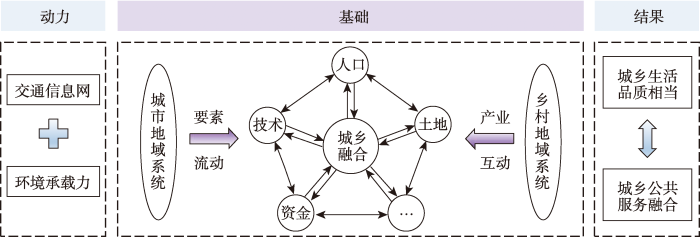
图2
城乡融合“基础—动力—结果”过程性框架
Fig.2
The "foundation-motivation-result" process framework of urban-rural integration (URI)
遵循全面性、代表性和科学性等原则,结合理论分析、频度统计与专家论证3种方法,本文从城乡融合发展的基础、动力和结果3个维度中选取26个指标,构建城乡融合水平指标体系(表1),包括反映城乡整体发展水平的综合类指标、城乡融合成效的对比类指标及农村发展实际的动力类指标,该指标体系科学反映了城乡互动过程,在一定程度上揭示了城乡融合发展的内在机理。具体而言,要素流动及产业互动是城乡融合的基础条件,分别从城乡人口聚集、就业结构、空间扩张、土地配置、农业资金与技术保障、产业产值及生产效率等方面选取相应指标;交通信息网及环境承载力是城乡融合的发展动力,主要从城乡交通可达性、信息通达性、污染状况、生态条件等方面选取指标;城乡居民生活品质提升和公共服务水平差异缩小是城乡融合的结果,分别从城乡经济总量、整体及稳定收入、家庭与社会消费、文化教育、医疗资源、基础设施、社会保障等方面选取相应指标。
表1 城乡融合水平指标体系
Tab.1
| 目标 | 一级指标 | 二级指标 | 三级指标 | 指标计算 | 类型 | 效应 |
|---|---|---|---|---|---|---|
| 城乡融合水平 | 基础 | 人口融合 | A1人口城镇化率(%) | 城镇人口/总人口 | 综合 | + |
| A2非农与农业就业比(%) | 第二、三产业从业人员数/第一产业从业人员数 | 对比 | + | |||
| A3城乡就业反差系数(%) | 城镇居民就业比重-农村居民就业比重 | 对比 | - | |||
| 土地流动 | A4土地城镇化率(%) | 建成区面积/土地总面积 | 综合 | + | ||
| A5城乡土地配置(%) | 农作物播种面积/建成区面积 | 动力 | + | |||
| 资金技术 | A6科技占财政支出比(%) | 科技支出/财政总支出 | 综合 | + | ||
| A7农业机械化水平(万kW/103 hm2) | 农业机械总动力/耕地灌溉面积 | 动力 | + | |||
| A8农林水务占财政支出比(%) | 农林水务支出/财政总支出 | 动力 | + | |||
| 产业互动 | A9非农产值与农业产值比(%) | 第二、三产业增加值/第一产业增加值 | 对比 | + | ||
| A10二元生产效率比(%) | (第一产业增加值/第一产业从业人员数)/(第二、三产业增加值/第二、三产业从业人员数) | 对比 | + | |||
| 动力 | 交通信息网 | B11交通网密度(km/km2) | (公路运营里程+铁路运营里程)/土地总面积 | 综合 | + | |
| B12互联网普及率(%) | 互联网上网人数/总人口 | 综合 | + | |||
| 环境承载力 | B13每千公顷化肥施用量(万t/103 hm2) | 化肥使用量/耕地灌溉面积 | 动力 | - | ||
| B14建成区绿化覆盖率(%) | 建成区绿化面积/建成区面积 | 综合 | + | |||
| B15每万人拥有公共厕所数(个/万人) | 公共厕所数/万人口数 | 综合 | + | |||
| 结果 | 收入消费水平 | C16地均GDP(元/km2) | GDP/土地总面积 | 综合 | + | |
| C17城乡居民人均收入比(%) | 城镇居民家庭人均可支配收入/农村居民家庭人均可支配收入 | 对比 | - | |||
| C18城乡居民人均工资性收入比(%) | 城镇居民人均工资性收入/农村居民人均工资性收入 | 对比 | - | |||
| C19城乡居民家庭人均消费比(%) | 城市家庭人均消费/农村家庭人均消费 | 对比 | - | |||
| C20城乡居民人均社会消费品零售额(万元/人) | 社会消费品零售额/总人口 | 综合 | + | |||
| 公共服务水平 | C21城乡基础教育师生比之比(%) | (城镇基础教育教师数/学生数)/(农村基础教育教师数/学生数) | 对比 | - | ||
| C22城乡人均拥有公共图书馆藏量(册/人) | 公共图书馆藏量/总人口 | 综合 | + | |||
| C23城乡每千人拥有医院卫生院床位数之比(%) | 城镇每千人拥有医院卫生院床位数/农村每千人拥有医院卫生院床位数 | 对比 | - | |||
| C24城乡每千人拥有卫生技术人员数比(%) | 城镇每千人拥有卫生技术人员数/农村每千人拥有卫生技术人员数 | 对比 | - | |||
| C25城乡人均用电量比(%) | 城镇人均用电量/农村人均用电量 | 对比 | - | |||
| C26城乡居民养老保险覆盖率(%) | (城乡居民基本养老保险投保人数+城镇职工基本养老保险人数)/总人口 | 综合 | + |
注:指标效应为正表示数值越大则城乡融合水平越高,指标效应为负表示数值越大则城乡融合水平越低。
1.2 驱动因素指标选取与处理
城乡融合是资源禀赋、经济社会、区域政策等多因素综合作用的结果。通过文献梳理,从自然环境、产业经济、社会生活、政策偏向4个维度12个指标探测城乡融合的核心解释变量(图3):
图3
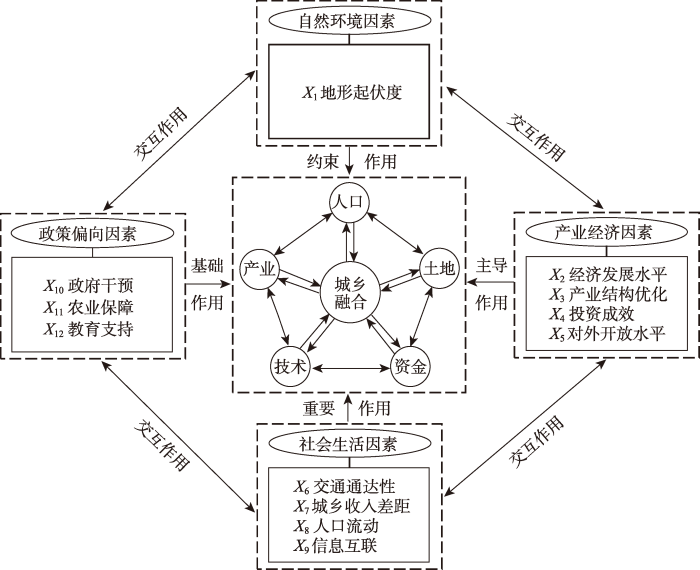
(1) 自然环境。地形条件制约土地的开发利用,从而约束地区农业发展和工业布局。选取地形起伏度(X1)[19]反映自然环境因素对城乡融合的影响。
利用地理探测器定量识别全国和区域尺度城乡融合水平空间分异的核心驱动因素及其交互作用。鉴于地理探测器的应用前提为“自变量属于类型量”,借助ArcGIS 10.5软件运用Jenks自然断裂分级法对各指标具体数值进行空间离散化处理,X1以中国DEM数据为基础,根据高程信息进行重分类,分为7个等级,X2~X12以区域统计数据为基础,按照行政区域进行赋值,分为5个等级。设置网格大小为50 km×50 km,进行等间距格点化处理,匹配每个格点的城乡融合水平和12个驱动因素的等级类型,分别作为地理探测器识别的因变量Y和自变量X。
1.3 数据来源
本文以中国31个省份(不包含港澳台数据)为研究单元,研究时段为2000—2020年,涉及的主要数据包括上述年份中国的DEM数据和经济社会统计数据。用于测算地形起伏度的DEM数据来自中国科学院地理科学与资源研究所的资源环境科学与数据中心(
1.4 研究方法
1.4.1 改进熵值法
综合评价中权重的确定主要包含主观赋值、客观赋值和主客观相结合3种方法。主观赋值与主客观相结合的方法都不同程度依赖于主观判断,导致结果的可信度降低。熵值法是运用信息熵原理评价研究对象的一种客观赋值法,但其仅适用于单一时间点的截面数据,无法实现三维立体数据的有效处理。为此,构建加入时间变量的改进熵值法评价模型[39],运用该评价模型能够实现不同年份城乡融合水平的比较,主要步骤如下:① 对所选指标进行标准化处理;② 确定指标比重、熵值和信息效用值,继而获得指标权重;③ 依据指标权重计算全国及31个省份的城乡融合水平综合得分。
1.4.2 kernel密度估计
kernel密度估计属于非参数估计,通过探究研究对象分布曲线的位置、形状、延展性等特征,直观揭示其动态演变趋势和区域差异。通过不同时期城乡融合水平kernel密度函数图,可视化展示其动态演进过程和绝对差异,具体公式如下:
式中:
1.4.3 地理探测器
地理探测器是探测空间分异性以及揭示驱动力的统计学方法[40]。通过地理探测器中因子探测和交互探测模块的运用,甄别驱动全国尺度和区域尺度 城乡融合水平空间分异的核心因素。探测模型为:
式中:q为探测因素X对城乡融合水平时空差异的作用强度值,取值范围为[0, 1],q值越大表示因子X对Y的影响作用越显著;L为因素X的分层总数,k是分层数(k=1,2,…,L),N为省区市总数量,Nk表示分层k上的省区市数量,
2 中国城乡融合水平时空分异识别
2.1 总体变化特征
据三大地带划分法将中国分为东、中、西部地区①(① 东部地区包括北京、天津、河北、辽宁、上海、江苏、浙江、福建、山东、广东、海南,中部地区包括山西、吉林、黑龙江、安徽、江西、河南、湖北、湖南,西部地区包括内蒙古、广西、重庆、四川、贵州、云南、陕西、甘肃、青海、宁夏、新疆、西藏。),2000—2020年各地区城乡融合水平均值呈“东部>全国平均≈中部>西部”顺序(图4),全国尺度城乡融合水平均值的分布范围为[0.193, 0.380],城乡融合水平整体较低,呈现“东部➝中部➝西部”阶梯式递减的地区分异格局。从演变趋势看,2000—2020年中国城乡融合水平均值以2002年为拐点呈先降后升的“√”型变化趋势,整体上呈现出明显的增长趋势。2002年来,在城乡统筹(2002—2005年)、新农村建设(2005—2012年)、城乡一体化(2012—2017年)、城乡融合(2017—2020年)等相关政策的落实下,城乡要素双向流动不断加快,城乡融合水平由“量变”向“质变”发展,推动城乡“互促”发展。
图4
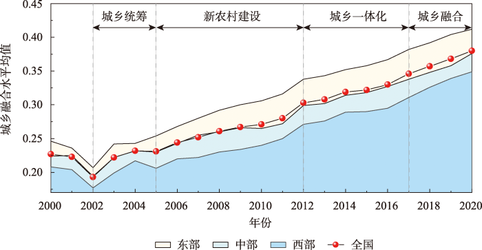
图4
中国及三大地区城乡融合发展水平均值变化
Fig.4
Changes in the average level of URI in China and its three regions
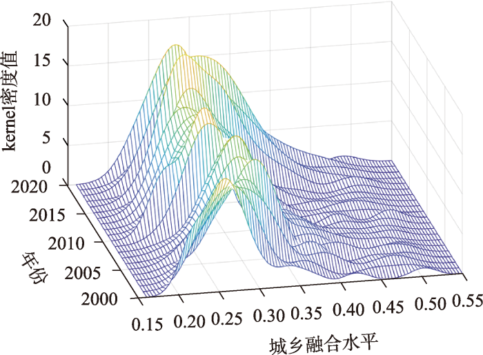
利用kernel密度估计揭示中国城乡融合水平及各省(区、市)空间差距的动态演变趋势(图5)。从分布位置看,研究期内分布曲线的中心线总体上随时间向右迁移,各年曲线均存在右偏分布特征,进一步反映中国城乡融合水平不断提升,且高值集聚分布明显。从分布形态看,主峰高度震荡上升,且宽度波动缩小,表明中国城乡融合水平的离散程度呈下降趋势,空间差异趋于缩小。从波峰数量看,曲线总体经历由“一主锋,多次锋”向“单峰”转变的过程,说明研究时段的前期存在梯度效应和分化态势,而后期中国城乡融合水平分化现象有所减弱。
图5
2.2 时空格局演化特征
基于Jenks自然断裂法,分别将2000、2007、2013、2020年中国城乡融合水平分为低水平区、次低水平区、中等水平区,次高水平区和高水平区5个等级(图6),以“胡焕庸线”为界,中国城乡融合水平呈现“东高西低”的空间格局,表现出“东部稳步增长、中西部逐步崛起”的特征,其具体演化特征为:
图6
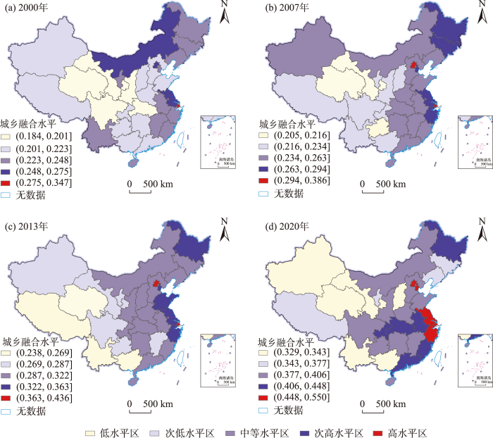
图6
中国城乡融合水平时空格局演变
注:本图基于自然资源部标准地图服务系统网站下载的审图号为GS(2022)4309号的标准地图绘制,底图无修改。
Fig.6
Spatiotemporal pattern evolution of URI level in China
(1) 中高值区持续增加,高值区中心极化特征突出,呈“带状”聚集趋势;中等水平区“集群化”特征有所减弱,呈现由东部向中西部蔓延的趋势。具体而言,2000年,城乡融合高水平区仅有上海,次高水平区为北京、江苏和内蒙古,总体呈零星分布,中等水平区主要分布在天津、黑龙江、吉林、辽宁、浙江、福建、安徽、江西等11个中部和东部的省份。2007年,高水平区包括北京和上海,以北京和上海为中心呈现空间极化态势;次高水平区包含天津、浙江、江苏、黑龙江和吉林5个省份;中等水平区集群化分布于内蒙古、河北、山东、河南、湖南、湖北、广东等13个省份。2013年,北京、上海仍为高水平区,次高水平区为黑龙江、天津、山东、江苏、浙江5个省份;中等水平区“集群化”特征最为明显,包括山西、陕西、重庆等14个省份。2020年,高水平区包括北京、上海、天津、浙江和江苏5个省份;次高水平区包括广东、福建、安徽、湖北、重庆、黑龙江6个省份;中等水平区趋于分散,其范围进一步向四川、贵州等中西部地区扩大。
(2) 低值区趋于减少,团簇于西部地区。具体而言,2000年,低水平区为青海、甘肃、陕西、湖北、四川5个省份,次低水平区包括新疆、西藏、山西、河北、重庆、贵州等11个省份;2007年,低水平区仅有青海、甘肃、重庆3个省份,次低水平包括西藏、云南、四川、广西等8个省份;2013年,低水平和次低水平区总体上集中在西部地区,较2007年无显著变化;2020年,低水平和次低水平区包括新疆、西藏、青海、甘肃、四川等10个省份,较2000年减少了6个,城乡融合发展态势向好。
3 中国城乡融合水平驱动因素探测
3.1 全国尺度
为探究全国尺度城乡融合水平产生异质性的核心因素变化,对2000、2005、2010、2015、2020年各驱动因素进行探测,对比历年q值排序前5位因素可知(表2),人口流动(X8)、经济发展水平(X2)、城乡收入差距(X7)和教育支持(X12)的q值排序至少在4个年份中位居前5名,表明这4个变量为驱动全国城乡融合水平空间分异的核心因素。
表2 全国尺度因子探测结果
Tab.2
| 代码 | 探测因子 | 2000年 | 2005年 | 2010年 | 2015年 | 2020年 | |||||||||
|---|---|---|---|---|---|---|---|---|---|---|---|---|---|---|---|
| q | 排序 | q | 排序 | q | 排序 | q | 排序 | q | 排序 | ||||||
| X1 | 地形起伏度 | 0.154** | 8 | 0.412** | 9 | 0.439** | 6 | 0.551** | 6 | 0.255** | 9 | ||||
| X2 | 经济发展水平 | 0.494** | 3 | 0.548** | 4 | 0.588** | 4 | 0.485** | 7 | 0.480** | 4 | ||||
| X3 | 产业结构优化 | 0.260** | 5 | 0.385** | 10 | 0.320** | 8 | 0.142** | 12 | 0.584** | 2 | ||||
| X4 | 投资成效 | 0.116** | 10 | 0.514** | 5 | 0.398** | 7 | 0.176** | 11 | 0.151** | 12 | ||||
| X5 | 对外开放水平 | 0.328** | 4 | 0.475** | 7 | 0.164** | 10 | 0.295** | 9 | 0.459** | 5 | ||||
| X6 | 交通通达性 | 0.016* | 12 | 0.094** | 12 | 0.153** | 11 | 0.279** | 10 | 0.199** | 11 | ||||
| X7 | 城乡收入差距 | 0.668** | 1 | 0.607** | 2 | 0.770** | 1 | 0.612** | 4 | 0.398** | 6 | ||||
| X8 | 人口流动 | 0.505** | 2 | 0.745** | 1 | 0.700** | 2 | 0.762** | 2 | 0.590** | 1 | ||||
| X9 | 信息互联 | 0.146** | 9 | 0.427** | 8 | 0.237** | 9 | 0.313** | 8 | 0.349** | 7 | ||||
| X10 | 政府干预 | 0.077** | 11 | 0.477** | 6 | 0.458** | 5 | 0.679** | 3 | 0.248** | 10 | ||||
| X11 | 农业保障 | 0.251** | 6 | 0.230** | 11 | 0.114** | 12 | 0.587** | 5 | 0.305** | 8 | ||||
| X12 | 教育支持 | 0.192** | 7 | 0.594** | 3 | 0.628** | 3 | 0.789** | 1 | 0.561** | 3 | ||||
注:**、*分别表示通过0.01、0.05的显著性水平检验。下同。
从核心因素的q值演化看,人口流动(X8)的q值历年稳定在0.5以上,均处于前2位,对全国城乡融合水平空间分异具有极强的解释力,这是由于农村人口向城市聚集,一方面推动城市空间扩张、提升城市经济产出,另一方面促使农村资源空间优裕、提高农村生产率,故有力解释城乡空间与经济的融合,但劳动力转移产生的资源消耗和环境污染等问题需予以重视;经济发展水平(X2)q值由2000年的0.494上升为2010年的0.588,而后持续下降至2020年的0.480,其原因是城乡经济逐步追求高质量发展,城乡融合的目标转变为“经济—社会—生态”多维度均衡发展,故经济因素的空间解释力有所下降;城乡收入差距(X7)的q值由2000年的0.668下降至2020年的0.398,对中国城乡融合水平的影响程度下降;教育支持(X12)q值从2000年的0.192持续升至2015年的0.789,而后略降为2020年的0.561,总体呈波动增大趋势,表明教育投入对城乡融合水平的影响程度显著增强,通过积累人力资本提高个体生产和配置能力,有效缓解城乡收入分配差距,但其驱动城乡融合水平的长期效应仍有待激发,需警惕城乡教育失衡导致农村人力资源枯竭。
研究期内产业结构优化(X3)和对外开放水平(X5)q值均波动上升,2020年分别处于第2位、第5位,表明这2个因素影响未来全国城乡融合水平的潜力较大;投资成效(X4)和政府干预(X10)q值均呈先增后减的“倒U”型趋势,说明固定资产投资和政府财政支出增加到某一临界点后,对城乡融合水平的影响程度不升反降;各驱动因素q值的标准差由2000年的0.189波动降至2020年的0.147,表明各因素驱动城乡融合水平的力度差距呈现缩小态势,即城乡融合水平空间分异的核心因素趋向多元,未来对中国城乡融合发展的优化探索需注重多维视角。
3.2 区域尺度
不同区域社会经济条件和自然资源禀赋的差异性,驱动城乡融合水平的核心因素存在空间异质性。为进一步揭示区域尺度城乡融合水平驱动因素的异质性及其演变,运用因子探测分别得出各驱动因素在不同时间节点上对东、中、西部地区城乡融合水平的解释力q值,q值越大的探测因素对城乡融合水平的影响作用越大(表3)。
表3 区域尺度因子探测结果
Tab.3
| 代码 | 探测因子 | 东部 | 中部 | 西部 | |||||
|---|---|---|---|---|---|---|---|---|---|
| 2000年 | 2020年 | 2000年 | 2020年 | 2000年 | 2020年 | ||||
| X1 | 地形起伏度 | 0.033* | 0.052* | 0.306** | 0.382** | 0.202** | 0.131** | ||
| X2 | 经济发展水平 | 0.525** | 0.751** | 0.561** | 0.535** | 0.906** | 0.421** | ||
| X3 | 产业结构优化 | 0.221** | 0.428** | 0.796** | 0.607** | 0.674** | 0.775** | ||
| X4 | 投资成效 | 0.618** | 0.735** | 0.993** | 0.854** | 0.573** | 0.709** | ||
| X5 | 对外开放水平 | 0.665** | 0.406** | 0.443** | 0.785** | 0.817** | 0.400** | ||
| X6 | 交通通达性 | 0.496** | 0.444** | 0.577** | 0.573** | 0.432** | 0.367** | ||
| X7 | 城乡收入差距 | 0.568** | 0.585** | 0.921** | 0.722** | 0.920** | 0.099** | ||
| X8 | 人口流动 | 0.524** | 0.408** | 0.990** | 0.364** | 0.870** | 0.766** | ||
| X9 | 信息互联 | 0.478** | 0.453** | 0.833** | 0.287** | 0.665** | 0.384** | ||
| X10 | 政府干预 | 0.426** | 0.691** | 0.346** | 0.535** | 0.363** | 0.848** | ||
| X11 | 农业保障 | 0.540* | 0.090* | 0.678** | 0.349** | 0.873** | 0.654** | ||
| X12 | 教育支持 | 0.467** | 0.222** | 0.314** | 0.492** | 0.418** | 0.948** | ||
从东部地区来看,2000年影响较大的核心因素为对外开放水平(X5)、投资成效(X4)、城乡收入差距(X7)、农业保障(X11)、经济发展水平(X2)及人口流动(X8)等;2020年为经济发展水平(X2)、投资成效(X4)、政府干预(X10)、城乡收入差距(X7)及信息互联(X9)等,表明21世纪初东部地区城乡融合水平长期由对外开放、投资、经济社会发展以及人口流动等较多因素驱动,到2020年时投资、政府行为等驱动效应更为凸显。2000—2020年,产业结构优化(X3)、政府干预(X10)、经济发展水平(X2)、投资成效(X4)及城乡收入差距(X7)等因素q值获得不同程度的增长,表明这些因素对东部地区城乡融合水平的影响程度增强;农业保障(X11)、教育支持(X12)、对外开放水平(X5)、人口流动(X8)及交通通达性(X6)等因素q值出现不同程度的下降,表明这些因素的作用下降。
从中部地区来看,2000年影响较大的核心因素为投资成效(X4)、人口流动(X8)、城乡收入差距(X7)、信息互联(X9)及产业结构优化(X3)等;2020年影响较大的驱动因素为投资成效(X4)、对外开放水平(X5)、城乡收入差距(X7)、产业结构优化(X3)及交通通达性(X6)等。2000—2020年,对外开放水平(X5)、教育支持(X12)、政府干预(X10)及地形起伏度(X1)等因素q值获得不同程度的增长,表明这些因素对中部地区城乡融合水平的影响程度增强;信息互联(X9)、人口流动(X8)、农业保障(X11)、产业结构优化(X3)及城乡收入差距(X7)等因素q值出现不同程度的下降,表明这些因素的作用下降。
从西部地区来看,2000年影响较大的核心因素为城乡收入差距(X7)、经济发展水平(X2)、农业保障(X11)、人口流动(X8)及对外开放水平(X5)等;2020年影响较大的驱动因素为教育支持(X12)、政府干预(X10)、产业结构优化(X3)、人口流动(X8)及投资成效(X4)等。2000—2020年,政府干预(X10)、教育支持(X12)、投资成效(X4)及产业结构优化(X3)等因素q值获得不同程度的增长,表明这些因素对西部地区城乡融合水平的影响程度增强;城乡收入差距(X7)、经济发展水平(X2)、对外开放水平(X5)、信息互联(X9)及农业保障(X11)等因素q值出现不同程度的下降,表明这些因素的作用下降。
3.3 交互探测
为探究各因素间交互作用对全国城乡融合水平的解释力强弱,对2000—2020年12个驱动因素进行交互探测(图7),任意2个因素之间的交互作用结果均呈现双因子增强或非线性增强,即双因子交互作用的驱动强度均大于单因素,表明全国城乡融合水平空间分异是多个驱动因素共同作用的结果。
图7
图7
中国城乡融合水平驱动因素交互探测结果
Fig.7
Interaction detection results of driving factors of URI level in China
2000—2020年,交互作用对全国城乡融合水平影响最强的2个因素分别是:交通通达性∩人口流动(2000年,q=0.931)、交通通达性∩人口流动(2005年,q=0.951)、经济发展水平∩城乡收入差距(2010年,q=0.933)、投资成效∩人口流动(2015年,q=0.968)、交通通达性∩人口流动(2020年,q=0.898),其中交通通达性(X6)和人口流动(X8)交互作用在2000、2005、2020年3个年份中均最强,说明这2个因素对全国城乡融合水平的交互解释力度最强,构建交通基础设施和人口双向流动的“双重”发展策略有助于提升中国城乡融合水平。经济发展水平(X2)、人口流动(X8)和教育支持(X12)与其他因素的交互作用显著增强,历年q值范围分别为[0.571,0.939]、[0.618,0.968]、[0.514,0.897],说明这3个因素大大增强了其他指标对全国城乡融合水平的影响,这与其单因素解释力较强具有一定的耦合性。2020年,地形起伏度(X1)和交通通达性(X6)单因素作用的q值较小,分别为0.255和0.199,但与其他各因素的交互作用显著增强,例如地形起伏度(X1)与经济发展水平(X2)、产业结构优化(X3)、人口流动(X8)、教育支持(X12)的交互解释力度均超过0.65,交通通达性(X6)与对外开放水平(X5)、人口流动(X8)、教育支持(X12)交互后的驱动作用均在0.75以上。整体而言,自然环境和基础设施建设是城乡融合水平的基础因素,需要借助经济产业与人力资本等力量共同实现城乡融合高质量发展。
4 结论、讨论及建议
4.1 结论与讨论
本文基于城乡融合“基础—动力—结果”过程性框架重构城乡融合水平指标体系,运用改进熵值法评价模型综合测算2000—2020年中国各省(区、市)城乡融合水平,通过kernel密度估计和地理探测器探究城乡融合水平时空格局演变及其驱动力异质性特征,主要结论如下:
(1) 2000—2020年中国城乡融合水平呈先降后升的“√”型演变特征,整体水平较低,形成“东➝中➝西”阶梯式递减的地区分异格局,各省(区、市)城乡融合水平的绝对差异趋于缩小,“分化”现象有所减弱。
(2) 从数量结构看,城乡融合水平低值区趋于减少,中高值区持续增加。从空间结构看,以“胡焕庸线”为界的中国城乡融合水平呈现明显的“东高西低”格局,高值区呈现以北京和上海为中心的空间极化特征,由“零星”分布向长江流域和东南沿海“带状”格局演进;中等水平区“集群化”特征有所减弱,呈现东部向中西部蔓延的趋势;低值区集中分布于西部地区,且其“空间锁定”现象被逐步打破。
(3) 从全国尺度看,城乡融合水平空间分异的核心因素为人口流动、经济发展水平、城乡收入差距和教育支持;潜力因素为产业结构优化和对外开放水平;投资成效和政府干预存在显著的“阈值”效应;各因素对城乡融合水平影响程度的差距波动缩小,即城乡融合水平的核心因素趋向多元。从区域尺度看,东部、中部和西部地区城乡融合水平的核心因素空间异质性明显,2020年东部地区为经济发展水平、投资成效、政府干预等,中部地区为投资成效、对外开放水平、城乡收入差距等,西部地区为教育支持、政府干预、产业结构优化等。从交互探测看,双因子交互作用结果为双因子增强或非线性增强;交通通达性和人口流动的交互解释力度最强;经济发展水平、人口流动和教育支持等影响程度较大的因素与其他因素的交互作用显著增强;地形起伏度和交通通达性单因素驱动作用不明显,但与其他因素交互作用显著增强。
本文测度了中国省域城乡融合水平,探究其时空格局和驱动因素异质性变化,在一定程度上为城乡融合政策差别化实施提供理论支撑。但在研究尺度、指标选取及驱动因素上仍有待进一步深入:① 研究区域仅以全国及省份等宏观尺度入手,若从县域、镇域或省—市—县等多尺度层面探讨城乡融合水平演变特征,则能更强针对性地为城乡融合发展路径提供理论支撑;② 受限于动态性指标获取,评价指标仍为静态形式,如何动态表示城乡间要素流动是今后研究需深入思考的方向;③ 驱动因素方面仅考虑自然、经济、社会和政策4个维度,但驱动城乡融合水平的因素往往更为复杂,因此在后续研究中应深入探讨历史发展、制度变迁、生态环境等多种因素的影响。
4.2 政策建议
(1) 强化中国城乡融合水平主导因素的驱动作用。研究表明,人口流动、经济发展水平、城乡收入差距和教育支持作为全国尺度城乡融合水平的高驱动因子,是区域差异化发展的主要原因。由此启示,中国应合理引导劳动力有序流动,提高经济发展水平,持续缩小城乡收入势差,通过加大基础教育投资释放劳动力资源的“知识红利”与“智慧红利”。
(2) 发挥产业结构优化与对外开放水平提升的反馈效应,释放城乡融合发展潜力。全国尺度因子探测结果显示,产业结构优化和对外开放水平是驱动中国城乡融合水平的潜力因素。中国应充分意识到产业结构转型升级以及区域商贸流改善对城乡融合的长效机制,一方面应加强农民职业技能培训以缓解产业结构偏离导致的“就业破坏”,助推产业结构与就业结构相匹配,同时合理引导农村土地流转,推动农业新业态构建,助力城乡融合;另一方面应积极打造现代商贸流通体系,提升区域整体对外开放水平,打通城乡流通的“微循环”,通过城乡消费差距缩小反哺于城乡融合。
(3) 规范政府行为,提高投资效益,冲破阈值效应的藩篱。考虑到政府行为和投资成效推动城乡融合水平具有阈值效应,单纯地增加政府财政支出和固定资产投资总量并不能长期有效促进城乡融合,故一方面应最大程度释放地方政府主导对城乡融合水平的正向效应,并及时纠偏其过度干预造成的资源配置扭曲行为;另一方面应积极提升政府对基础民生投资的善治能力,促使投资成效向改善民生和城乡融合的目标移动。
(4) 稳步提升农村基础设施通达水平,构建“多组合”发展策略。通过交互探测分析可知交通通达性与其他社会经济因素对城乡融合水平的交互解释力度显著增强。由此启示,中国应打好交通基础设施的“组合拳”,例如,在提高农村基础设施通达水平的同时,适当降低投资门槛,创新基础设施投融资方式,深化户籍制度改革,同步提升农村教育、医疗、卫生等公共服务水平,以此推动城乡在经济、社会、生活各方面的融合。
(5) 重视中国城乡融合水平空间非均衡性,探索区域差别化发展路径。结合区域尺度因子探测,以各区域城乡融合水平的核心因素为抓手,制定差异化协调推进战略。从东部地区看,较高的经济发展水平为城乡发展提供了基础支撑,而影响城乡融合发展的体制机制障碍尚未根本消除,应通过鼓励金融资本、社会资本向农村倾斜等方式,激活农村经济发展动力,发挥城乡经济发展的“滚雪球效应”,同时加大地方政府扶持力度,深化制度改革和政策创新。从中部地区看,对外开放水平是影响城乡融合水平提升的核心因素,应积极融入国家对外开放战略政策,加强内陆及对外开放水平,充分发挥其承东启西的区位优势。从西部地区看,教育支持和政府干预为城乡融合水平的最高驱动因素,通过政府宏观调控有助于实现城乡教育资源的均衡配置,应持续推进边陲地区对口帮扶,加强乡村教育配套设施建设,鼓励远程教育开展等,推进城乡教育深度融合。
参考文献
城乡融合理论: 阶段、特征与启示
[J].
The theory of urban-rural integration: Stages, characteristics and enlightenment
中国新时代城乡融合与乡村振兴
[J].
DOI:10.11821/dlxb201804004
[本文引用: 2]

城市与乡村是一个有机体,只有二者可持续发展,才能相互支撑。依据人地关系地域系统学说,城乡融合系统、乡村地域系统是全新认知和理解城乡关系的理论依据。针对日益严峻的“乡村病”问题,全面实施乡村振兴,既是推进城乡融合与乡村持续发展的重大战略,也是破解“三农”问题,决胜全面建成小康社会的必然要求。本文探讨了新时代城乡融合与乡村振兴的基础理论,剖析了乡村发展面临的主要问题,提出了问题导向的中国城乡融合与乡村振兴科学途径及研究前沿领域。结果表明:① 城乡融合与乡村振兴的对象是一个乡村地域多体系统,包括城乡融合体、乡村综合体、村镇有机体、居业协同体,乡村振兴重在推进城乡融合系统优化重构,加快建设城乡基础网、乡村发展区、村镇空间场、乡村振兴极等所构成的多级目标体系。② 中国“三农”问题本质上是一个乡村地域系统可持续发展问题,当前乡村发展正面临主要农业生产要素高速非农化、农村社会主体过快老弱化、村庄建设用地日益空废化、农村水土环境严重污损化和乡村贫困片区深度贫困化等“五化”难题。③ 乡村是经济社会发展的重要基础,城乡融合与乡村振兴战略相辅相成,乡村振兴应致力于创建城乡融合体制机制,推进乡村极化发展,按照产业兴旺、生态宜居、乡风文明、治理有效、生活富裕的要求,构建乡村地域系统转型—重构—创新发展综合体系。④ 乡村振兴地理学研究应着眼于乡村地域系统的复杂性、综合性、动态性,探究以根治“乡村病”为导向的新型村镇建设方案、模式和科学途径,为实现新时代中国乡村振兴战略提供理论参考。
Research on the urban-rural integration and rural revitalization in the new era in China
DOI:10.11821/dlxb201804004
[本文引用: 2]
Cities and villages are components of a specific organism. Only the sustainable development of two parts can support the prosperous development as a whole. According to the theory of man-earth areal system, urban-rural integrated system and rural regional system are the theoretical bases for entirely recognizing and understanding urban-rural relationship. To handle the increasingly severe problems of "rural disease" in rapid urbanization, accelerating rural revitalization in an all-round way is not only a major strategic plan for promoting the urban-rural integration and rural sustainable development, but also a necessary requirement for solving the issues related to agriculture, rural areas, and rural people in the new era and securing a decisive victory in building a moderately prosperous society in all respects. This study explores the basic theories of urban-rural integration and rural revitalization and analyzes the main problems and causes of rural development in the new era, proposing problem-oriented scientific approaches and frontier research fields of urban-rural integration and rural revitalization in China. Results show that the objects of urban-rural integration and rural revitalization is a regional multi-body system, which mainly includes urban-rural integration, rural complex, village-town organism, and housing-industry symbiosis. Rural revitalization focuses on promoting the reconstruction of urban-rural integration system and constructs a multi-level goal system including urban-rural infrastructure networks, zones of rural development, fields of village-town space and poles of rural revitalization. Currently, the rural development is facing the five problems: high-speed non-agricultural transformation of agriculture production factors, over-fast aging and weakening of rural subjects, increasingly hollowing and abandoning of rural construction land, severe fouling of rural soil and water environment and deep pauperization of rural poverty-stricken areas. The countryside is an important basis for the socioeconomic development in China, and the strategies of urban-rural integration and rural revitalization are complementary. The rural revitalization focuses on establishing the institutional mechanism for integrated urban-rural development and constructs the comprehensive development system of rural regional system, which includes transformation, reconstruction and innovation in accordance with the requirements of thriving businesses, pleasant living environments, social etiquette and civility, effective governance, and prosperity. Geographical research on rural revitalization should focus on the complexity and dynamics of rural regional system and explore new schemes, models and scientific approaches for the construction of villages and towns, which are guided by radical cure of "rural disease", implement the strategy of rural revitalization polarization, construct the evaluation index system and planning system of rural revitalization, thus providing advanced theoretical references for realizing the revitalization of China's rural areas in the new era.
城乡融合与乡村振兴: 理论探讨、机理阐释与实现路径
[J].
DOI:10.11821/dlyj201811001
[本文引用: 3]
缩小城乡差距,促进城乡均衡发展,实现城乡居民生活质量等值,是乡村振兴和城乡融合发展的重要目标。通过基础理论的分析,探讨了城乡融合与乡村振兴科学内涵,剖析了城乡融合与乡村振兴的相互关系,构建了城乡空间均衡模型和定义城乡等值线,提出了中国城乡融合与乡村振兴实现途径及需要深入研究的方向。结果表明:① 城乡融合发展是基于空间布局优化和制度供给创新的经济、社会、环境全面融合发展,“乡村振兴五边形”和“人—地—钱—业”是乡村振兴的核心内涵;城乡融合与乡村振兴战略相互支撑,城乡融合和乡村振兴的过程是城乡空间动态均衡的过程。② 城乡发展的空间均衡模型可以较好地阐释促进城乡融合发展、实施乡村振兴的关键问题,通过城乡要素的重新优化配置和人口的流动,城乡人均综合发展效益逐渐趋于相等;城乡等值线可以进一步解释城乡发展空间均衡的动态过程与传导机理。③ 从政策制度构建、“点轴”渐进扩散、分区分类推进、典型发展模式提炼等方面探讨乡村振兴的科学路径,可以为中国乡村振兴战略实施提供理论参考。
Urban-rural integration and rural revitalization: Theory, mechanism and implementation
DOI:10.11821/dlyj201811001
[本文引用: 3]
Rural revitalization and urban-rural integration aim at narrowing the gap between urban and rural areas, promoting balanced development and realizing the equivalent life quality between urban and rural residents. Spatial equilibrium and its quantitative expression provide a new perspective to explain the pattern, process and mechanism of urban-rural integration and rural revitalization. Through the analysis of basic theory, this study discusses the scientific content and interaction between urban-rural integration and rural revitalization, sets up the urban-rural spatial equilibrium model, defines the urban-rural development isolines, works out the way to implement the urban-rural integration and rural revitalization in China, and addresses the potential for further research. The results show that: (1) Theory of regional system of man-land relationship and theory of spatial structure are the important theoretical basis for urban-rural integration and rural revitalization. The urban-rural integrated development depends on the all-round development of economy, society and environment with optimized spatial layout and innovative system, and rural revitalization mainly refers to the "pentagon of rural revitalization" and "people-land-capital-industry"; Urban-rural integration and rural revitalization strategy support each other, and the process of urban rural integration and rural revitalization is a dynamic equilibrium process between urban and rural areas. (2) The key issues of implementing rural revitalization and urban-rural integration can be illustrated through the urban-rural spatial equilibrium model, and the overall per capita benefits in rural areas gradually tend to be the same as that in cities by the re-optimization of urban-rural factors and population mobility; the dynamic process and mechanism of urban-rural integration spatial equilibrium is further interpreted via the urban-rural development isolines. (3) Exploring the implementation path of scientific rural revitalization strategy can achieve the goal of urban-rural integration and urban-rural spatial equilibrium development. The scientific path of rural revitalization is discussed from the perspectives of policy system construction, "pole-axis" spatial progressive diffusion, sub-area classification and typical development pattern, and it can provide theoretical reference for the strategy implementation of China's rural revitalization.
从城乡一体化到城乡融合: 新型城乡关系的思考
[J].
DOI:10.13249/j.cnki.sgs.2018.10.006
[本文引用: 1]
新型城镇化和乡村振兴战略的深入实施,推动城乡关系进入了一个融合发展的新阶段。采用Citespace1.0软件分析及文献归纳方法,识别了城乡关系研究热点,梳理了城乡关系研究在理论探索、影响因素、测度与评价、空间组织及推进策略等方面的研究进展。在此基础上,重点对面向城乡融合发展的新型城乡关系研究进行了总结,从理论基础与总体思路、多源数据与方法集成等方面提出了基于要素流动的城乡融合分析框架,指出了城乡融合研究的重点是基于多源数据的城乡关系测度与评价,城乡要素流动的特征、格局与效应,城乡要素融合发展的流动机制,城乡融合发展调控策略等。
From town-country integration to urban-rural integration: New thinking on the relationship between urban and rural areas
DOI:10.13249/j.cnki.sgs.2018.10.006
[本文引用: 1]
The in-depth implementation of the new urbanization and rural revitalization strategy has pushed the urban-rural relationship into a new stage of integrated development. Based on Citespace1.0 software analysis and literature induction method, the paper identified the research hotspots of urban-rural relationship, reviewed the research progress of urban-rural relationship. Which included theoretical connotation and influencing factors of urban-rural relationship, measurement and evaluation of urban-rural connection, urban-rural spatial organization and development mode, and coordinated development of urban-rural areas and promotion strategy. Combining with the social economic background of information revolution and the change of urban-rural relationship in China, we points out that the construction of urban-rural relationship in the new period needs to change the traditional urban-rural relationship centered on the city, promote the integration of urban and rural areas and the formation of a new pattern of equal development between urban and rural areas. Based on this, we puts forward and discusses the construction and overall thought of a new urban-rural relationship toward urban-rural integration development. Then we proposes a framework for urban-rural integration analysis based on elements flow, puts forward the general idea of analyzing the characteristics, pattern and mechanism of urban-rural elements flow, which is supported by flow space theory and new mobility paradigm, multi-source data and visual analysis. The paper emphasizes the importance of measurement and evaluation of urban-rural relationship and the flow of urban-rural elements. The characteristics, pattern and mechanism of urban-rural factors flow, and the regulation and control strategy of the integration development of urban-rural areas are discussed in detail. The paper also explores the construction of the urban-rural integration database, the measurement of the flow of urban-rural elements and their spatial-temporal changes, and spatial simulation and visualization expression and other methods and techniques.
大都市边缘区城乡融合发展模式及效应评价: 以长沙市望城区为例
[J].
Development model and effect evaluation of urban-rural integrated in metropolitan fringe areas: A case study of Wangcheng District, Changsha City
Identifying risk factors of urban-rural conflict in urbanization: A case of China
[J].DOI:10.1016/j.habitatint.2014.06.007 URL [本文引用: 1]
Progress of research on urban-rural transformation and rural development in China in the past decade and future prospects
[J].DOI:10.1007/s11442-016-1318-8 URL [本文引用: 1]
国外城乡关系理论演变及其启示
[J].
Review about the theoretical evolvement of rural-urban relations
基于地理学视角的城乡融合发展研究进展与展望
[J].
Research progress and prospects of urban-rural integrated development based on geographical perspective
Coping strategies of urban and rural welfare organisations and the regulation of the poor
[J].DOI:10.1080/13563467.2012.664124 URL [本文引用: 1]
Rural-urban connectivity and agricultural land management across the Global South
[J].
Location, location, location: Examining the rural-urban skills gap in Canada
[J].
DOI:10.1016/j.jrurstud.2019.10.032
[本文引用: 1]
The elevated demands of the new knowledge economy pose particular challenges to rural and northern regions in Canada, long acknowledged by policymakers to suffer from acute human capital deficits. Rural residents obtain lower levels of education than their urban counterparts and those that do obtain post-secondary training often migrate to urban regions offering abundant employment opportunities and higher wages. Despite an emerging consensus around over skill deficits across rural regions, Canadian researchers have yet to systematically explore contemporary rural-urban differences in human capital using refined measures of literacy and numeracy skills. We ameliorate this deficiency by mapping rural-urban disparities in skills across the working age population (16-65) using Statistics Canada's 2012 Longitudinal International Study of Adults (LISA). Our results indicate that residents from smaller population centers and rural areas within Canada show significantly lower skills proficiencies. These differences across location of residence shrink considerably when controlling for education level, underscoring the need to enhance post-secondary access in rural areas.
The urban-rural divide in radical right populist support: The role of resident's characteristics, urbanization trends and public service supply
[J].
DOI:10.1007/s00168-021-01046-1
[本文引用: 1]
In a number of recent elections in Western Europe, support for far-right populist parties has been significantly higher in non-urban areas than in urban areas. This paper answers the following questions; (1) Can the urban–rural divide in voting behavior be explained by the fact that urban and non-urban populations differ in terms of education, income and other individual characteristics of voters, or by variations in immigration? (2) Can variations in public service supply explain parts of the urban–rural divide in far-right populist support? and (3) How does population growth and public services relate to voting behavior when examining urban and rural municipalities separately? The analyses combine survey data on individual characteristics and register data aggregated on municipalities. The results in this paper suggest that voter characteristics and immigration explain a substantial part of the urban–rural divide. However, the propensity to vote for a far-right populist party is still higher in regions with lower population growth even when controlling for individual characteristics and immigration. When considering public service supply, the urban–rural divide is further weakened. The propensity to vote for a far-right party decreases with higher public service supply and higher share of immigrants. The findings in this paper thereby support the hypothesis that individuals in shrinking areas with lower access to public services are likely to respond to the deterioration of their location by casting a vote on the far-right (i.e., protest voting).
Land use, transitions and urban-rural integrated development: Theoretical framework and China's evidence
[J].
迈向城乡共治: 改革开放以来城乡关系演变解读
[J].
DOI:10.18306/dlkxjz.2021.05.014
[本文引用: 1]
城乡关系历来是经济社会发展的重要关系及党和政府关注的重大问题。为探究城乡关系及其治理逻辑,论文借助CiteSpace软件分析改革开放以来城乡关系的研究热点,结合时代背景解读城乡关系的演变历程,进而揭示城乡关系的脉络特征与治理变革的内在逻辑。研究表明:改革开放以来城乡关系的演变经历了4个阶段,形成了“城乡关系向好发展—城乡关系再度失衡—城乡关系调整完善—城乡关系一体化发展”的演变脉络;折射出“打破城乡分割”“偏向城市领域”“统筹城乡发展”“推进城乡一体化”的治理逻辑;十九大以来,城乡关系向着城乡融合的方向发展,迈向城乡共治是新时代城乡融合发展的内在要求与治理趋势。最后,文章从废除城乡二元体制、建立新的配套体制机制,打破学科界限、融合跨学科知识和实践交叉应用,新型城镇化和乡村振兴两大战略有机结合等方面对城乡融合发展与城乡共治进行了研究展望。
Toward rural-urban co-governance: An interpretation of the change of rural-urban relationship since the reform and opening up
DOI:10.18306/dlkxjz.2021.05.014
[本文引用: 1]
The relationship between urban and rural areas in China has been an important relationship for economic and social development and a major concern of the party and the government. In order to explore the relationship between urban and rural areas and its governance logic, the CiteSpace software was used to analyze the research hotspots of rural-urban relationship since the reform and opening up in the 1970s and to interpret its change based on the historical background, and then reveal the contextual characteristics of rural-urban relationship and the internal logic of governance reform. The research shows that since the reform and opening up, rural-urban relationship has gone through four stages—from an improving urban-rural relationship, to rural-urban re-separation, rural-urban relationship adjustment, and integrated rural-urban development. The process reflects the governance logic of breaking the rural-urban division, favoring the urban field, balancing rural-urban development, and promoting rural-urban integration. Since the 19th National Congress of the Communist Party of China, the relationship between urban and rural areas has developed in the direction of rural-urban integration. Rural-urban co-governance is the internal demand and governance trend of integrated rural-urban development in the new era. Finally, the article discussed the prospect of integrated rural-urban development and rural-urban co-governance from the aspects of abolishing the rural-urban dual system and establishing new supporting systems and mechanisms, breaking disciplinary boundaries and integrating interdisciplinary knowledge and cross-application of practice, and organically combining the two strategies of new urbanization and rural revitalization.
马克思恩格斯城乡融合理论及其在中国的应用与发展
[J].
Marx and Engels' theory of urban-rural integration and its application and development in China
Revitalize the world's countryside
[J].DOI:10.1038/548275a URL [本文引用: 1]
基于土地系统科学的土地利用转型与城乡融合发展
[J].
DOI:10.11821/dlxb202102004
[本文引用: 1]
土地系统科学的研究视角可为促进城乡融合发展的土地利用转型研究提供参考借鉴。本文在梳理国际上土地系统科学发展历程基础上,基于土地系统科学研究视角探讨了土地利用转型影响城乡融合发展的理论框架、方式与路径以及促进城乡融合发展的土地利用转型调控途径与措施。土地系统科学致力于监测土地变化,解释驱动因素和反馈机制,理解发生于土地上的人类—环境相互作用,实现将对土地系统的科学发现转化为可持续土地利用解决方案。土地系统运行以土地可持续利用与人类福祉为准绳,显化为土地利用的多维效应。通过科学管控土地利用转型实现土地系统的良好运行能够影响城乡融合发展进程。土地利用转型通过效率提升、价值显化、要素流通与结构优化4大渠道,在“强整体”效应与“补短板”效应的作用下助推城乡融合发展。基于土地系统科学视域下促进城乡融合发展的土地利用转型调控需要重塑土地权能体系,推进国土空间综合整治,健全土地利用转型管控体系。
Urban-rural integrated development and land use transitions: A perspective of land system science
DOI:10.11821/dlxb202102004
[本文引用: 1]
The research perspective of land system science can provide a reference for the study of urban-rural integrated development promoted by land use transitions. Based on the review of the development of land system science, this paper discusses the theoretical framework concerning land use transitions affecting urban-rural integrated development guided by land system science, the influential ways and paths of land use transitions on urban-rural integrated development, and the measures of promoting urban-rural integrated development via adjusting and controlling land use transitions. Land system science is committed to monitoring land use change, explaining the driving forces and feedback mechanism, understanding the human-environment interactions occurring on land, and translating scientific findings on land system into solutions for sustainable land use. The operating of land system takes sustainable land use and human well-being as the criterions, and manifests as multi-dimensional effects of land use. Operating well the land system via scientifically adjusting and controlling land use transitions can affect the process of urban-rural integrated development. Land use transitions promote the integrated development of urban and rural areas under the effects of strengthening the whole and reinforcing weak links through four channels, i.e., efficiency improvement, value embodiment, development elements circulation and structure optimization. In order to promote the integrated development of urban and rural areas from the perspective of land system science, the adjustment and control of land use transitions need to reshape the land use rights system, to promote the integrated consolidation of territorial space, and to improve the management and control system of land use transitions.
大都市区城乡融合系统耦合协调度时空演化及其影响因素: 以环首都地区为例
[J].
Spatiotemporal evolution of coupling coordination degree of urban-rural integration system in metropolitan area and its influencing factors: Taking the Capital Region as an example
长三角地区城乡融合发展水平、演化及影响因素
[J].
DOI:10.31497/zrzyxb.20220607
[本文引用: 4]
在城乡发展差距日益扩大的背景下,以长三角地区作为研究案例,运用熵值法计算长三角地区2008—2018年城乡融合发展指数,并利用地理探测器模型分析城乡融合水平的主要影响因素及其演变特征。结果表明:长三角地区城乡融合发展水平呈现出“高低高”结构向“Σ”转变的空间演变特征,空间融合发展水平和社会融合发展水平的高值区大致呈现出“Σ”的空间分布特征,经济融合发展水平呈现出“高低高”的圈层结构特征,生活融合发展水平大致呈现出西高东低的空间分布格局;从地理探测器模型结果来看,经济发展水平、产业高级化、财政支农支出比例、财政分权有助于城乡融合的发展,经济发展的速度、产业结构偏离、城乡基本建设支出比例不利于城乡融合的发展;从时间变化上看,政府力量在逐步减弱,市场力量在逐渐增强。
The development level, evolution and influencing factor of urban-rural integration in the Yangtze River Delta
DOI:10.31497/zrzyxb.20220607
[本文引用: 4]
In the context of the growing gap between urban and rural development, this paper takes the Yangtze River Delta region as a research case and uses the Entropy method to calculate the development index for the 2008-2018 urban-rural integration and spatial integration, economic integration, social integration and lifestyle integration. And then it uses the Geographic Detector Model to analyze the main influencing factors and evolution characteristics of the level of urban-rural integration. The results show that the development level of urban-rural integration in the study region is characterized by spatial evolution from the "high-low-high" structure to a "Σ"-shaped pattern; from the perspective of the spatial characteristics of the urban-rural integration subsystem, the high value of the development level of spatial integration and the level of social integration presents the spatial pattern of a "Σ" shape, the economic integration development level is characterized as high and low circle structure, and the life integration development level roughly presents the spatial pattern of high in the west and low in the east. Seen from the results of the geographic detector model, the level of economic development, industrial advancement, the proportion of fiscal expenditures on agricultural support, and fiscal decentralization are conducive to the development of urban-rural integration; while the speed of economic development, the deviation of industrial structure, and the proportion of urban-rural infrastructure expenditures are not conducive to the urban-rural integration. From the temporal perspective, government power is gradually weakening, and market power is gradually intensifying.
时空交互视角下淮海经济区城乡融合发展水平演化
[J].
DOI:10.31497/zrzyxb.20200809
[本文引用: 3]
以淮海经济区为研究对象,界定城乡融合内涵,并构建多维指标体系,测度城乡融合发展水平,并探索时空演化特征及驱动机理。(1)在空间集聚方面,淮海经济区城乡融合发展水平集聚较为明显,并且集聚性整体呈现增强趋势。(2)在时空联动方面,具有相对动态的局部空间结构和相对稳定的空间依赖方向,同时空间格局演化方面具有较强的整合性;城市自身因素对城乡融合发展水平空间结构的改变影响较大,受相邻城市城乡融合发展水平的溢出效应的影响较小。(3)要素驱动模式方面,低分位驱动和高分位驱动城市的城乡融合发展水平变化受经济发展—城镇化驱动,低分位制约类型城市的城乡融合发展水平变化受城镇就业—政府行为制约,高分位制约类型城市的城乡融合发展水平变化受产业—政府行为制约。
Evolution of urban-rural integration in Huaihai Economic Zone from the perspective of spatio-temporal interaction
DOI:10.31497/zrzyxb.20200809
[本文引用: 3]
Rural-urban integration is an inevitable trend of the development of rural-urban relations. Studies on urban-rural integration are the requirement for giving play to the comprehensive advantages of geography in order to serve the national strategy. This paper took Huaihai Economic Zone as the research object, constructed multi-dimensional index system, and measured the level of urban-rural integration. The characteristics of spatio-temporal evolution and its driving mechanism were also discussed. Some conclusions were drawn as follows. The difference of urban-rural integration level among cities in Huaihai Economic Zone was relatively small. The level of urban and rural integration showed the characteristics of agglomeration in space. For most cities, local spatial structure of urban-rural integration was more dynamic, and its fluctuation was relatively small. Spatial pattern evolution showed the characteristics of strong integration. Factors of the city itself had more influence on the change of spatial structure of urban-rural integration. It was less affected by the spillover effect of the level of urban-rural integration in neighboring cities. The change of urban-rural integration in the cities was driven by economic development and urbanization. The change of urban-rural integration in the cities, which was at low level, was restrained by urban employment and government action. The change of urban-rural integration in the cities, which was at high level, was restrained by industry and government action. Finally, different countermeasures and suggestions were put forward for different types of cities.
等值化理念下中国城乡融合多维审视及影响因素
[J].
DOI:10.11821/dlyj020190572
[本文引用: 6]
基于等值化理念采用全局主成分分析(GPCA)和空间自相关分析等方法,测度并审视中国城乡多维融合发展;选取空间计量模型探索推进城乡融合的体制机制。研究发现:① 中国城乡融合发展趋势向好且推进有序。社会和经济融合始终分列第一和第二主导位次,生态环境融合水平亦稳步提升。② 城乡融合热点和冷点区基本分列于“胡焕庸线”东南和西北两侧。人口融合沿东中西递减;空间融合形成“北上广”为主的“核心-边缘”区;东部沿海是经济融合扩散互溢区,而生态环境和经济融合存在空间“错位”;社会融合高值簇集中在中部。③ 破解人才瓶颈、夯实“三权分置”、健全财政体制并创新金融服务、调整产业结构和推动三产融合,打好人、地、钱、业组合拳同时规范政府行为、完善社会服务体系、构建小农户与现代农业有机衔接机制等均利于推进城乡融合。
Review of urban-rural multi-dimensional integration and influencing factors in China based on the concept of equivalence
DOI:10.11821/dlyj020190572
[本文引用: 6]
Based on the urban-rural equivalence, the Global Principal Component Analysis (GPCA) method is used to measure the China's urban-rural multi-dimensional integration levels, and the Global and Local Moran Index, Local Getis-Ord Gi * Index are performed to reveal the spatial distribution of urban-rural multi-dimensional integration levels in China during 2000-2016. And finally, the spatial econometric model is introduced to explore the influencing factors of urban-rural integration development from the aspects of labors, land, capitals and industries. Research findings are as follows: (1) the trend of urban-rural integration development in China is well and orderly, but has regional heterogeneity. The agglomeration effect is obvious in Eastern China, and the social and economic coordination level has always occupied the first and the second places. (2) China's urban-rural multi-dimensional integration levels often show spatial autocorrelation. The HH values of urban-rural integration overall level are concentrated in Central China and Eastern China, while the LL values are gathered in Western China. The hot and cold spots are located to the southeast and northwest of Heihe-Tengchong Line, respectively. Also the high values of economic integration have always corresponded to those of ecological and environmental integration. Population integration level decreases from Eastern to Western China. Spatial integration level presents the "core-edge" structure such as Beijing, Shanghai and Guangdong. Spatial spillover effect of the economic integration development is obvious in the coastal region of China, while the development of ecological environment integration and economic integration has spatial dislocation. And the clusters of social integration high values are in Central China. (3) The ways of the urban-rural multi-dimensional integration are as follows: Firstly, we should improve the quality of rural labor forces and promote the interaction between urban and rural residents. Secondly, we should stimulate the multi-function of rural land and control the disorderly urban expansion. Thirdly, we should take financial expenditures in a reasonable range and provide a perfect financial support in urban and rural areas. Finally, industrial restructuring is also needed. And moreover, regulating the behavior of the local governments will be benefit to the urban-rural multi-dimensional integration and good governance in China.
中国城乡转型的时空格局及其优化决策
[J].
DOI:10.18306/dlkxjz.2021.11.001
[本文引用: 1]
城乡转型是一个多领域、多层次的综合过程。科学认知城乡转型的概念内涵,系统探讨城乡转型的格局、过程和机理,对于解决新时代突出的城乡发展不平衡、乡村发展不充分问题具有重要意义。在城乡转型理论认知的基础上,论文综合解析了中国省域城乡发展水平及其时空格局,并基于城乡发展水平耦合协调度剖析了城乡转型的格局,探讨了不同类型城乡转型区城乡融合发展的关键及其对策。结果表明:① 城乡转型是城市地域系统演化与乡村地域系统演化交互作用的结果,其外在表征是这2个过程耦合协调的状态;② 2000—2018年,各省城市和乡村发展水平快速上升,城乡发展水平耦合协调度实现了由濒临失调向中级协调的转变,但中西部地区的耦合协调度显著低于东北地区和东部沿海地区;③ 2000—2018年,全国城乡转型整体上实现了由低水平城乡统筹向中等水平城乡融合的转变,在空间上呈现出中西部地区城乡转型滞后于东部沿海地区的特征;④ 全国城乡发展可划分为高水平城乡融合区、中等水平城乡融合区、低水平城乡融合Ⅰ区和低水平城乡融合Ⅱ区4种类型,各类型区城乡转型的关键在于通过深化改革、创新机制、补齐短板等措施建立健全城乡融合发展的体制机制,不断推进新型城镇化发展和乡村振兴战略落实。
Spatio-temporal patterns of urban-rural transformation and optimal decision-making in China
DOI:10.18306/dlkxjz.2021.11.001
[本文引用: 1]
Urban-rural transformation (URT) is a comprehensive process with the characteristics of multi-domains and multi-levels. A scientific understanding of the concept and connotation of URT and a systematic discussion of the patterns and mechanism of URT are of great significance to solving the problems of unbalanced urban-rural development and insufficient rural development. Based on the theoretical cognition of URT, this study comprehensively analyzed the urban-rural development level and its spatial-temporal patterns in China, revealed the patterns of URT according to the coupling coordination degree of urban-rural development level, and discussed the key of urban-rural integrated development in different types of URT areas. The results show that URT is the result of the interaction between the change of urban regional system and the change of rural regional system, and its external representation is the coupling coordination state of the two different but closely related processes. From 2000 to 2018, the level of urban and rural development in all provinces of China's mainland has risen rapidly, and the coupling coordination degree of urban and rural development level has changed from being on the verge of imbalance to intermediate coordination. Spatially, the provincial coupling coordination degree of the central and western regions is significantly lower than that of the northeast and eastern regions. Accordingly, URT in China has realized the transformation from low-level urban-rural coordination to medium-level urban-rural integration, showing a spatial characteristic that provincial URT in the central and western regions lags behind the eastern areas, especially Beijing and the provinces in the Yangtze River Delta, where urban-rural development has entered or will soon enter the stage of high-level urban-rural integration. According to the features of URT in each province, URT in China can be divided into four types, that is, high-level urban-rural integrated area, medium-level urban-rural integrated area, low-level urban-rural integrated area Ⅰ, and low-level urban-rural integrated area Ⅱ. To continuously promote the development of new-type urbanization and the implementation of rural revitalization strategy, it is urgent to establish and improve the system and mechanism of urban-rural integrated development through measures such as deepening the reform, innovating the mechanism, and making up for the shortcomings.
中国城乡融合发展水平测度研究
[J].
Research on measurement of urban-rural integration development level
The allocation and management of critical resources in rural China under restructuring: Problems and prospects
[J].DOI:10.1016/j.jrurstud.2016.03.011 URL [本文引用: 1]
淮海经济区城乡空间融合格局及形成机制
[J].
DOI:10.31497/zrzyxb.20200811
[本文引用: 2]
城乡融合发展是解决城乡差距过大、城乡不平衡不协调问题的关键举措,也是城乡动态均衡的发展过程。聚落镶嵌、交通可达、发展均衡是城乡融合发展的空间表象。基于空间视角构建城乡融合发展的评价指标体系,综合运用景观分析、可达性分析和耦合协调分析等方法揭示淮海经济区城乡空间融合发展的要素格局特征,并结合回归模型探究其形成机制。结论如下:(1)城乡空间融合是城乡结构优化的进程,可以从城乡聚落连通性、城乡交通便捷性和城乡发展均衡性等方面研判城乡空间融合发展的综合水平。(2)淮海经济区城乡空间融合发展的各要素指标存在较大差异,综合水平指标由中心向外围递减,可划分为协调融合型、协调关联型和欠协调分割型三种地域类型。(3)经济发展水平、城乡规模、产业关联是影响该区域城乡空间融合的关键动力因素,而传统农业和工业的推动作用不显著。镇域和村域尺度城乡融合发展的理论和实证研究是后续工作的重要方向。
Regional differential characteristics of urban-rural space integration development in Huaihai Economic Zone and its formation mechanism
DOI:10.31497/zrzyxb.20200811
[本文引用: 2]
Urban-rural integration development is the key initiative to solve the problems of excessive income gap between urban and rural areas and unbalanced and uncoordinated urban-rural development, and it is also the inevitable requirement of rural revitalization. This paper discusses the connotation of urban-rural integration development, and constructs an evaluation index system of urban-rural integration development by entropy weight method. Based on these, it reveals the characteristics of the factor pattern of urban-rural integration development in Huaihai Economic Zone in combination of the methods of landscape analysis, spatial analysis and coupling coordination analysis, and explores the influence mechanism of urban-rural integration development combined with regression model, in order to provide a theoretical reference for the urban-rural integration development in the border areas of underdeveloped provinces. The results are as follows: (1) Urban-rural integration is the process of rebuilding urban-rural relationship. The comprehensive level of urban-rural integration development can be described from the connectivity of urban-rural space, the convenience of urban-rural transportation, the balance of urban-rural public services and the livability of urban-rural ecological environment. (2) There are great differences in the indicators of urban-rural integration development in Huaihai Economic Zone. The comprehensive level index decreases from the center to the periphery. According to the spatial correlation and index coordination, Huaihai Economic Zone can be divided into three types: coordinated development region, associated development region and divided development region. (3) The level of economic development, the scale of urban-rural areas, and the industrial linkage are the key dynamic factors affecting the urban-rural integration development. However, the development of traditional agriculture and industry, as well as the urban-rural population structure, have no significant effect on regional urban-rural integration development. The theoretical and empirical research on urban-rural integration development at the scales of town and village is an important direction of follow-up work.
中国城乡一体化水平的时空特征与门槛效应
[J].
Spatio-temporal characteristics and threshold effect of urban-rural integration in China
2003年以来东北地区城乡协调发展的时空演化
[J].
Spatial-temporal evolution features of urban and rural harmonious in Northeast China since 2003
“城乡共富”: “共同富裕”的内涵要义与实践遵循
[J].
"Urban and rural common prosperity": The practice connotation of "common prosperity"
城乡融合发展驱动共同富裕的内在机理与实现路径
[J].
Internal mechanism and realization path of urban-rural integration development driving common prosperity
以共同富裕为目标推进城乡融合发展的逻辑与路径
[J].共同富裕是推进城乡融合发展的重要目标。马克思城乡发展思想和共同富裕思想是我国城乡发展实践的理论来源。中国城乡发展进入城乡融合发展阶段是在马克思主义理论指导下中国共产党理论创新的结果。从共同富裕角度分析城乡融合发展的逻辑与路径,为观察和理解中国的共同富裕问题和城乡发展问题提供了一种思路,有助于推进城乡融合发展实践和理论创新。新时代以共同富裕为目标推进城乡融合发展,一要坚持“目标—动力—机制”一体两翼的发展逻辑,即坚持目标与过程相统一,不断增强改革和创新发展动力,坚持完善机制;二要走“核心力量领导—满足需求—创造供给—共享机会成果”四位一体的发展路径。
The logic and path of promoting integrated development between rural and urban areas with the goal of common prosperity
Building new countryside in China: A geographical perspective
[J].DOI:10.1016/j.landusepol.2009.06.006 URL [本文引用: 2]
乡村重构与转型: 西方经验及启示
[J].
DOI:10.11821/dlyj020181133
[本文引用: 1]
20世纪80年代以来,乡村重构与转型成为西方国家乡村地理学研究的重要前沿课题。在揭示西方国家乡村重构过程、梳理转型特征、探析驱动因素的基础上,聚焦于乡村发展的系统总结及其提供的经验借鉴与启示。西方国家乡村重构经历了从“资本、土地、产权”主导的经济维度重构到“话语、他者、建构”主导的社会维度重构、再到“主体、文化、网络”主导的综合维度重构阶段;乡村转型特征可凝聚为生产性乡村-消费性乡村-多功能乡村-全球化乡村的逻辑主线;后工业化、逆城市化、全球化是推动西方国家乡村重构与转型的主要因素。中国乡村发展具有迥异于西方国家的背景和特征,但相关经验及认识仍然能够为理解中国乡村实践发展、推动相关理论建设提供启示,并从“要素/重构/过程”-“功能/转型/结果”视角对当代中国乡村重构与转型进行了系统思考。
Rural restructuring and transformation: Western experience and its enlightenment to China
DOI:10.11821/dlyj020181133
[本文引用: 1]
Rural restructuring and transformation has been frontier in Rural Geography studies of Western countries since the 1980s. Our objective in this paper is to draw lessons from the rural development of Western countries for the implementation of the rural revitalization strategy of China. The paper reveals the rural restructuring process, the characteristics of rural transformation, and the driving factors of Western countries, and summarizes the rural development practice in Western countries and its enlightenment to China. The energy crisis and post-industrialization in the 1970s, and technological progress (especially the rapid development of the Internet) since the early 1990s constituted important contexts for the rural restructuring and transformation in Western countries in three phases. The first phase is the economic dimension of restructuring dominated by "capital, land, and property rights". The second phase is the social dimension of restructuring dominated by "discourse, otherness, and construction". The third phase is the comprehensive dimension of restructuring dominated by "subject, culture and network", the essence of which is the reorganization of rural elements and their relationships as a result of the insertion of the exogenous subject, or urban area, capital and culture. The transformation characteristics have been concluded in a logic line which starts from productive countryside to consumptive countryside, then to multifunctional countryside, and lastly, to current global countryside. Rural transformation, of which the substance is the change of rural nature, is the direct result of rural restructuring. Post-industrialization, counter-urbanization, and globalization are the main factors that drive rural restructuring and transformation. Meanwhile the evolution of global geopolitical pattern has an impact on rural restructuring. Finally, despite the difference of background and characteristics of rural development between China and Western countries, it is believed that the experience from Western countries can contribute to providing enlightenment for understanding the practice of rural China's development and promoting its theory construction. In consideration of the issue that there is not unified conceptual framework for rural restructuring and transformation in China, which is a disadvantage of the relevant studies on rural China, the rural development practice and theoretical understanding in Western countries can provide some beneficial help for deepening the recognition of rural restructuring and transformation. It is noteworthy that because of different contexts between China and Western countries, Western practice and experience should not be directly copied by China without taking the differences into account. In addition, rural restructuring and transformation in contemporary China can be discussed from the perspectives of factors, reconstruction, process and function, transformation, consequence. Specifically, the paper proposes a rural revitalization blueprint for China, which sets global countryside, productive countryside, and multifunctional countryside as development orientations for eastern, central and western China, respectively.
Measurement of urban-rural integration level and its spatial differentiation in China in the new century
[J].
西部新型城镇化与乡村振兴协调的时空特征及影响机制
[J].
Spatial and temporal characteristics and influence mechanism of coordination between new-type urbanization and rural revitalization in Western China
The impact of work and non-work migration on household welfare, poverty and inequality
[J].DOI:10.1111/ecot.2011.19.issue-4 URL [本文引用: 1]
新时代城乡融合发展水平的测度研究: 基于新发展理念的视角
[J].
A study on the measurement of urban-rural integration in the New Era: Based on the new development concept
东北三省城乡协调发展格局及影响因素
[J].
DOI:10.13249/j.cnki.sgs.2019.08.012
[本文引用: 1]
以东北三省36个地区为研究对象,系统构建了城乡协调的指标体系,采用基尼系数、空间自相关和空间回归等方法探讨了2005年、2010年和2015年东北三省城乡协调的空间格局和影响机制。研究表明:① 东北三省城乡协调度的区域差异不断扩大且具有明显的空间集聚特征,但集聚程度趋于减弱。② 不同地区城乡协调水平变化各异。研究期内,大连市和锦州市一直处于高水平城乡协调状态,朝阳市长期处于低水平城乡协调状态。鹤岗市和七台河市城乡协调度位次上升最明显,哈尔滨市和辽源市城乡协调度位次下降最显著。③ 从空间格局来看,中级城乡协调区增多且向北移动,初级城乡协调区减少且向中部集中,“南北高,中间低”的城乡协调格局基本形成。与此同时,城乡协调的冷热点均不断收缩,空间极化效应趋于减弱。④ 城镇化和农业规模化经营是促进东北城乡协调发展的主要力量,工业化并未显著促进东北城乡协调发展且与城乡协调发展负相关,农业现代化经营对城乡协调发展有正向作用,交通因素在近些年的促进作用逐渐凸显,经济发展水平与信息化水平对东北城乡协调发展的作用还不明显。
Spatial pattern of urban-rural coordination development in Northeast China
DOI:10.13249/j.cnki.sgs.2019.08.012
[本文引用: 1]
Coordinating urban-rural coordinated development is an important foundation for achieving economic sustainable development of region. This paper selects 36 prefecture-level units in Northeast China as samples and constructed systematic index system to evaluate the level of urban-rural coordinated development. Then, the paper uses Gini coefficient, spatial autocorrelation and spatial regression to research the spatial pattern and influence mechanism of urban-rural coordinated development in Northeast China in 2005, 2010 and 2015. The result shown that: 1) The regional difference of urban-rural coordination degree in Northeast China has shown an expanding trend, and the phenomenon of spatial agglomeration is obvious, but the intensity of spatial agglomeration is declining. 2) The level of urban-rural coordination varies diferent in different regions. During the study period, Dalian and Jinzhou have always been high level of urban-rural coordinated area, and Chaoyang has always been a low level of urban-rural coordinated area. Hegang and Qitaihe were the most obvious upward cities of urban-rural coordination order, while Harbin and Liaoyuan declined most significantly. 3) From the perspective of spatial pattern, intermediate urban-rural coordination areas increased and moved northward, while primary urban-rural coordination areas decreased and concentrated in the middle. Then, formed a "north-south high, middle low" urban-rural coordination pattern. At the same time, the cold and hot spots of urban-rural coordination are shrinking, and the spatial polarization effect tends to weaken. 4) Urbanization and large-scale agricultural management have a positive effect on urban-rural coordinated development, industrialization does not significantly promote the urban-rural coordination in northeast China and is negatively related to the urban-rural coordination, agricultural modernization plays a positive role in the urban-rural coordinated development. In recent years, transportation gradually plays an positive role in urban-rural coordinated development. Economic development level and informatization level in the urban-rural coordinated development in northeast China are not obvious.
基于熵值法的西部新型城镇化发展水平测评
[J].
Evaluation of the development level of new urbanization in Western China based on entropy method
地理探测器: 原理与展望
[J].
DOI:10.11821/dlxb201701010
[本文引用: 1]
空间分异是自然和社会经济过程的空间表现,也是自亚里士多德以来人类认识自然的重要途径。地理探测器是探测空间分异性,以及揭示其背后驱动因子的一种新的统计学方法,此方法无线性假设,具有优雅的形式和明确的物理含义。基本思想是:假设研究区分为若干子区域,如果子区域的方差之和小于区域总方差,则存在空间分异性;如果两变量的空间分布趋于一致,则两者存在统计关联性。地理探测器q统计量,可用以度量空间分异性、探测解释因子、分析变量之间交互关系,已经在自然和社会科学多领域应用。本文阐述地理探测器的原理,并对其特点及应用进行了归纳总结,以利于读者方便灵活地使用地理探测器来认识、挖掘和利用空间分异性。
Geodetector: Principle and prospective
DOI:10.11821/dlxb201701010
[本文引用: 1]
Spatial stratified heterogeneity is the spatial expression of natural and socio-economic process, which is an important approach for human to recognize nature since Aristotle. Geodetector is a new statistical method to detect spatial stratified heterogeneity and reveal the driving factors behind it. This method with no linear hypothesis has elegant form and definite physical meaning. Here is the basic idea behind Geodetector: assuming that the study area is divided into several subareas. The study area is characterized by spatial stratified heterogeneity if the sum of the variance of subareas is less than the regional total variance; and if the spatial distribution of the two variables tends to be consistent, there is statistical correlation between them. Q-statistic in Geodetector has already been applied in many fields of natural and social sciences which can be used to measure spatial stratified heterogeneity, detect explanatory factors and analyze the interactive relationship between variables. In this paper, the authors will illustrate the principle of Geodetector and summarize the characteristics and applications in order to facilitate the using of Geodetector and help readers to recognize, mine and utilize spatial stratified heterogeneity.
