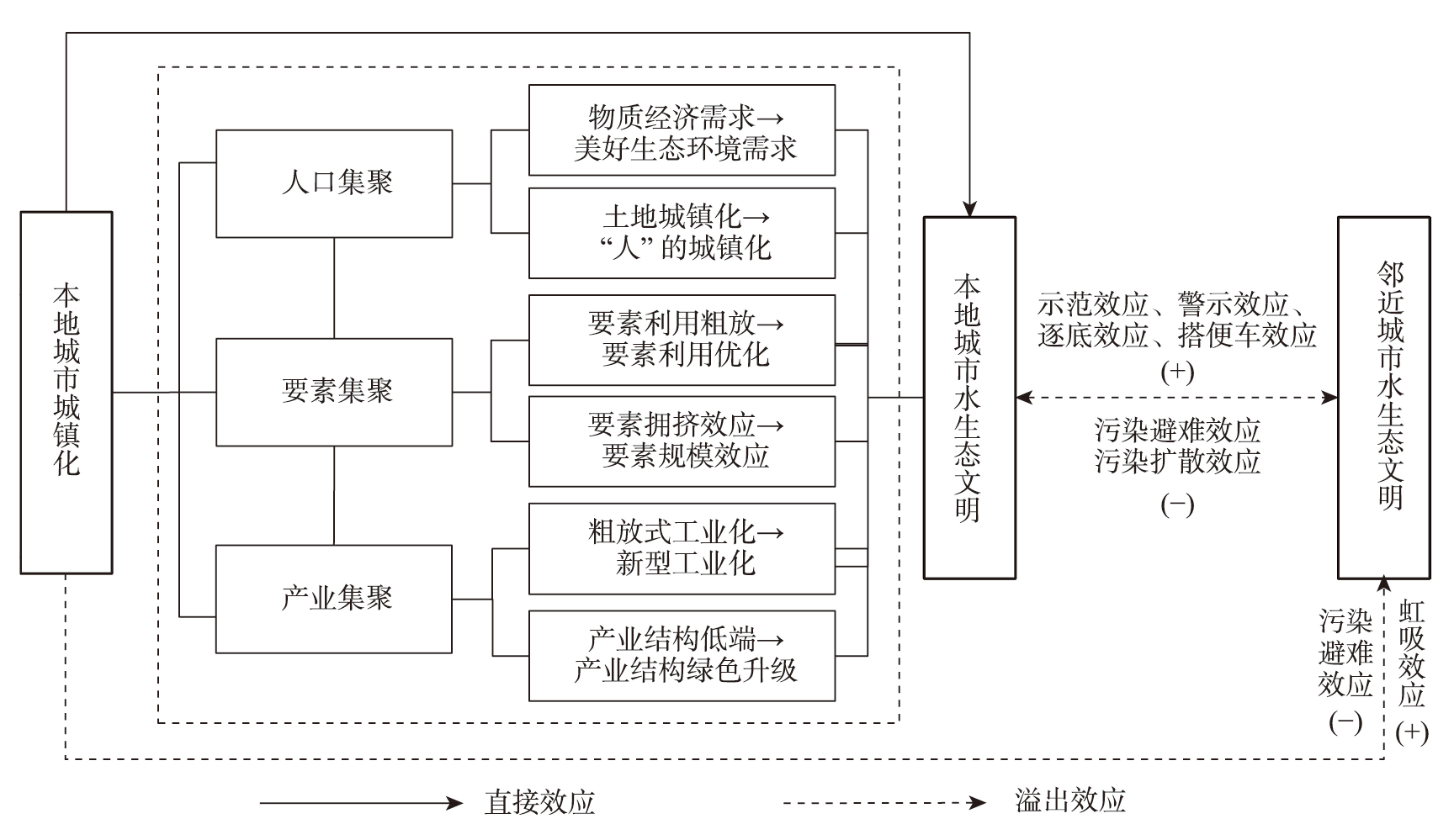
New urbanization is an important carrier of ecological civilization construction. How to promote the construction of water ecological civilization through new urbanization is a major practical problem facing the Huaihe River Eco-economic Belt in the process of modernization in which people and nature live together in harmony. This study empirically examined the mechanism of influence and spatial effects of urbanization on the construction of water ecological civilization using a spatial econometric model based on the urban panel data of the Huaihe River Eco-economic Belt from 2006 to 2020. The results are as follows: 1) The impact of comprehensive urbanization and population urbanization on the construction of water ecological civilization in the Huaihe River Eco-economic Belt follows a typical environmental Kuznets curve, exhibiting a "U"-shaped relationship. The urbanization restrains the construction of water ecological civilization in its early stage of development. Once the level of urbanization reaches a certain threshold, this effect will become positive. 2) The urbanization of population in each city has reached the inflection point value in 2014, while the comprehensive urbanization level has not yet reached the inflection point, therefore it is necessary to speed up the conversion of the transferred agricultural population into urban residents and effectively promote the new urbanization with people as the core. 3) The urbanization of the Huaihe River Eco-economic Belt has a significant inverted "U"-shaped spillover effect on water ecological civilization construction. Meanwhile, water ecological civilization construction in the region exhibits a negative spatial spillover effect. Therefore, the Huaihe River Eco-economic Belt should establish a sound system for the protection of water ecological civilization and strengthen the coordinated construction of urbanization and water ecological civilization in order to enhance the quality of new urbanization development and create an ecological demonstration belt that is harmonious between humans and water. This study offers a new perspective for analyzing the interplay between urbanization and water resource, and provides theoretical reference and empirical evidence for leveraging the new urbanization to promote the construction of water ecological civilization.
Accelerating the flow of green technology to enhance the sharing of green technologies among cities is not only a key measure to implement the green development strategy and achieve the dual carbon goals, but also a key step to promote the cross-regional flow of factors and build a large national unified market. This study examined the intercity green technology flow by intercity green patent transfer, and analyzed the spatiotemporal evolution patterns of intercity green technology flow in the Yangtze River Economic Belt from 2001 to 2020 with the help of big data mining and GIS spatial analysis. The emission reduction effects of green technology flow was studied from the perspective of technology agglomeration. This study found that: 1) The green technology flow within the Yangtze River Economic Belt was mainly dominated by the Yangtze River Delta region, and the level of cross-regional green technology flow was low. From the perspective of flow directions, cross-regional green technology diffusion has experienced the development path of random flow → agglomeration to the Yangtze River Delta → mixed flow. 2) The Yangtze River Economic Belt green technology diffusion activities at the national level were highly concentrated in the Yangtze River Delta region, with the Chengdu-Chongqing region gradually emerging, while the Beijing-Tianjin region and the Pearl River Delta were the main partners in the flow of green technologies of the Yangtze River Economic Belt, thus forming a rhombic network with the Beijing-Tianjin, Yangtze River Delta, Pearl River Delta, and Chengdu-Chongqing regions as the hubs. 3) The regression results show that there was a scale threshold effect in the local emission reduction effect brought about by green technologies acquired from the outside, that is, local carbon emission reduction can only be realized after the green technologies acquired from the outside has reached a certain scale.
Characteristic protection villages encapsulate the historical trajectory and long-term adaptation of the Chinese nation to the living environment, with specific distribution patterns and policy implications. Using 9381 characteristic protection villages listed in the national-level directory as research samples, this study focused on the policy-driven geographical attributes of these villages to depict the spatial heterogeneity of their distribution at multi-scales. It also examined the attributes of these villages to elucidate their preferences for habitats. Furthermore, it combined the habitat and policy aspects to reveal the influencing factors and mechanisms behind the heterogeneous distribution of these villages. The research findings are as follows: 1) From the perspective of spatially stratified heterogeneity, characteristic protection villages tend to cluster more in the northern regions with lower density, exhibiting a clear zonal distribution pattern in the east-west direction. The uneven distribution becomes increasingly pronounced from the provincial, municipal, to county scales. 2) From the perspective of local spatial heterogeneity, at different scales, these villages exhibit a hot spot areas in the south and cold spot areas in the north distribution pattern. However, the scale variation in spatial pattern is significant, with a finer spatial pattern emerging at the county level. 3) From the perspective of habitat preference, characteristic protection villages are predominantly located in areas characterized by a subtropical humid climate, on gentle slopes and sunny slopes in low mountain areas, and along the banks of small to medium-sized rivers. They also show a preference for regions marked by economic underdevelopment, proximity to major roads, proximity to national key cultural relics protection units (within 20 km), and locations 20-80 km from central cities. 4) From the perspective of causal factors and mechanisms, the distribution of these villages is primarily influenced by a combination of factors including climatic conditions, cultural resources, transportation location, and selection policies. It is the result of the joint action of policy-oriented mechanisms and habitat preference mechanisms. The research results can provide scientific reference for the revitalization decision-making of Chinese characteristic protection villages.
Examining the external environment, endogenous driving forces, and trend of development of new agricultural business entities, and enhancing the new momentum of agricultural and rural development, have strategic significance for the modernization of agriculture and rural areas in China. However, most studies only focus on the stock data of new agricultural business entities at a certain point in time, and do not consider the survival and changes of various new agricultural business entities, nor do they consider the survival differences of new agricultural business entities in different regions. Based on the list of national key leading enterprises of agricultural industrialization, typical national cases of farmers' cooperatives and family farms published by the Ministry of Agriculture and Rural Development from 2000 to 2022, and the data related to new agricultural business entities from the Yellow Pages of China's Agricultural Enterprises, a research framework on the influencing factors of the survival of new agricultural business entities was established from the perspective of "individual characteristics-stage of evolution-innovation ability" using spatial econometric analysis and survival analysis. This study examined the spatial distribution characteristics of the survival and development of new agricultural business entities, analyzed the influencing factors of regional development differences, and optimized the development strategies and found that: 1) The entry and exit of new agricultural business entities showed an inverted U-shaped curve, and the actual number of existing entities gradually increased. 2) The survival time of new agricultural business entities differed between regions, and the high-high agglomeration areas were mainly concentrated in the central and eastern regions. 3) Individual characteristics and innovation ability had a positive impact on the survival time of new agricultural business entities, and the stage of evolution had a negative impact. 4) With the passage of time, the influence of the scale of assets and the number of associated economic organizations of the new agricultural business entities on their survival time gradually decreased, and the influence of geographical factors gradually weakened as well. This study provides an empirical basis for the survival analysis of new agricultural business entities and a reference for studying the geographical characteristics of their development and evolution.
Tourism destination loyalty is an effective perspective for studying changes in tourist sources of tourism destinations. In order to enhance the effectiveness of the concept of loyalty, this study took Zibo as an example and used interview and text analysis methods to examine the causes and consequences of the "rushing to Zibo for barbecue" event, and deduced and analyzed the loyalty of tourists and local residents to Zibo barbecue over three time periods from the perspective of scales. The main conclusions of this study are as follows: 1) Loyalty analysis from the perspective of scales can comprehensively analyze the reasons and possibilities of multiple subjects' loyalty attitudes and behaviors from the dimensions of local industrial structure, policy and governance, and cultural symbols, among others. 2) This research explored the scale practice affected by social media attention, and explore how the local government in Zibo and the media at all levels, resorting to social media attention, scaled up Zibo barbecue to a cultural label, and how the tourists and local residents downscaled the kindness in human nature to a multi-dimensional consumption experience in the city. 3) In terms of policy recommendations, the study suggests that local governments maintain brand popularity through festivals every year, but it is necessary to make tourists feel the characteristics of festival carnival without hierarchy, norms, and constraints. During the festival, cultural exchange activities between college students, relevant enterprises, and local public institutions can be added to enhance the possibility of tourists entering Zibo. This study combined the concepts of scale transformation and tourism loyalty to build an academic analysis framework, providing recommendations for improving the sustainability of tourist sources under the impact of the "Internet celebrity" phenomenon.
Appropriate visual perception location is a necessary condition for marvellous landscape experience, and rich visual perception spatial information resources will be helpful for exploring the overall perception of beautiful places. Linear cultural heritage not only contains rich resource value and profound cultural heritage assets, but also has important values in the attributes of visual landscape resources. However, the ability of the GIS viewshed computation results to characterize the visual relationship between the visual location and landscape semantics is insufficient for further carrying out the deep value mining of visual landscape resources. Based on the existing methods of landscape visual perception calculation, this study designed the landscape visual perception location model (LVPLM) for linear cultural heritage, and developed the organization method and application logic of the LVPLM dataset based on the NetCDF multidimensional raster data structure. The LVPLM dataset expresses the visual perceptual location through the two-dimensional geographic coordinates and the semantic information of the target landscape through the semantic feature point coding, and then constructs the visual relationship between the visual perceptual location and the landscape semantics, and realizes the information integration of the target landscape, the perceptual location, and the visual state. This study also designed three application modes of the LVPLM dataset, namely "drilling", "slicing", and "dicing", to lay the foundation for multi-modal landscape visual perception information mining and analysis. This study selected the linear cultural heritage landscape resources of the Great Wall for empirical research, established the LVPLM dataset of the Gubeikou Great Wall, and collected visual comparison verification data through field investigation and survey, evaluated the basic credibility of the dataset, initially proved the feasibility and application value of the LVPLM model, and also provided a new data resource for the high-quality construction of the Great Wall National Cultural Park. In addition, the LVPLM model also provides new ideas for the study of the human-environment relationship from the perspective of information expression of interaction perception between humans and the landscape.
Exploring the mechanism of impact of the built environment on fitness vitality in urban outdoor spaces is of great significance for promoting national fitness. Taking the Wuhan urban area as an example, this study investigated the intensity of fitness vitality in outdoor spaces based on Keep fitness trajectory data. The hierarchical linear modeling (HLM) and multiscale geographically weighted regression (MGWR) models were employed to analyze the influence of the built environment on fitness vitality and its spatial variations. The results reveal the following: 1) Significant differences exist in fitness vitality among different functional areas. Green-dominated spaces exhibit the highest fitness vitality, with density of sports facilities and water area coefficient playing a more pronounced role in promoting fitness in such areas. Residential-dominated spaces also demonstrate considerable fitness vitality, with more prominent positive effects from street density and floor area ratio. In contrast, industrial-dominated spaces exhibit the weakest fitness vitality, while the degree of point of interest (POI) mixture and land prices show significant positive effects in such areas. 2) There are substantial disparities in fitness vitality among different locations, generally exhibiting a core-periphery structure with evident clustering characteristics. Moreover, the influences of POI mixture, road density, building density, and green space ratio vary significantly across different locations. The research findings demonstrate the multifaceted impact of the urban built environment on outdoor space fitness vitality and provide valuable planning recommendations for optimizing city functionality and form to create fitness-friendly environments.
A series of problems caused by rapid urbanization have a negative impact on the mental health of residents. As an essential health intervention, green spaces facilitate resident exposure to the natural environment and relieve mental stress. However, existing studies mainly use cross-sectional data, making it difficult to reveal the causal relationship between green space and mental health. In addition, few studies focused on the differences in the mental health effect of green space among different social groups. Therefore, we used a natural experiment approach to explore the impact of a large-scale greenway intervention—the East Lake Greenway in Wuhan, China—on residents' mental health. We collected data from the health effect questionnaires in 2016 and 2019 (before and after the intervention) among residents living around the greenway, used the difference-in-differences model to explore the causal relationship between green space intervention and residents' mental health changes, and combined stratified analysis to reveal differences in the causal effect of green space on mental health across various social groups. The results show that: 1) The green space intervention significantly promoted the improvement of mental health for the experimental group. 2) The causal effect of green space intervention on residents' mental health was not significantly different among groups with different gender and education levels, but there were significant differences among groups with different occupations and income levels, indicating that the greenspace intervention has significantly improved the mental health of the unemployed, low-income, and low-middle income groups. Overall, the construction of large green spaces can effectively improve the mental health of surrounding residents, especially for disadvantaged groups such as the unemployed and low-income groups. Green space interventions are critical for improving the mental health of residents and alleviating inequalities in mental health benefits due to differences in socioeconomic status.
With China's urbanization entering the middle and late stages of development, spatial production has significantly altered the social and ecological environments, and the construction of China's ecological civilization is encountering fresh challenges. Urban social theory encompasses ecological values beyond its social-spatial implications. The alienation of nature and the dysfunction of human-environment relationships remain focal points of urban social theory. By reflecting on the relationship between humans and nature, this theory presents an ecological analysis of urban space. It identifies three stages: First, it exposes the alienation of humanized nature from first nature; second, it highlights the disintegration and uneven distribution of ecological space between urban and rural areas; and third, it draws attention to the commodification, hierarchical, and differentiated development of the ecological space of urban society itself. The theory of urban society posits that the governance practice of "autogestion" can help alleviate the conflict between humans and the environment. It also advocates for the construction of an autonomous governance mechanism. Within a hypermobile society, China's ecological governance encounters unique challenges. Three imbalances are evident: The first is the imbalance in the governance system between first nature and humanized nature; the second is the imbalance in the governance organizational structure between urban and rural areas and between regions; and the third is the imbalance in the supply and demand of ecological goods within the social space. To achieve balanced ecological development through ecological governance, we must begin with three key points: Initially, focus on the rights orientation and establish a new concept of full society participation in ecological governance; secondly, expand spatial boundaries and create a new pattern of social-ecological integration and development; and lastly, improve ecological resilience and establish a novel mechanism of ecological governance based on the orientation of self-management. These endeavors will ultimately facilitate the creation of a beautiful China.
The global development of the Internet and mobile communication technology has greatly expanded individuals' access to and occupation of space and social resources. In the interaction and integration of cyberspace and real space, cyberspace has been interpreted in geographical and sociological dimensions, and the conceptual connotation has shifted from technology to space, society, and media. New technologies create new problems. Geographers have discussed the impact of the Internet and other information technologies on individual activities, urban space, and social development. However, there is still a lack of research on geographical concepts and geographic characteristics in cyberspace, which has become an obstacle to the development of geography of cyberspace. This study focused on the research of cyberspace in the field of social geography, used bibliometric methods to identify the research hotspots of scholars in China and internationally in the field of cyberspace geography in different periods, examined the development of cyberspace and its social-spatial attribute construction process, and based on the perspective of virtual-real hybrid space, summarized the progress of the social geographical research on cyberspace from the aspects of line decay, media space and virtual representation. This review aims to enhance understanding and exploration of geographic phenomena and social issues in cyberspace, and to advance the field of cyberspace geography.
In the context of the digital age, the emergence of information and communication technology (ICT) provides a new space for children's growth. This study collected a total of 89 publications in English related to ICT and children's geography through the Web of Science (WoS) SSCI collection and Google Scholar, and summarized the research connotation of ICT. From a technical perspective, this article summarized the technological changes of ICT in children's daily lives and its research applications in children's geography. By constructing a framework of review of globalization-localization at the macro level, public space-learning space-home space at the meso level, and personal identity construction at the micro level, the relevant research on ICT and children's groups was interpreted from a geographical perspective. Finally, by breaking the independent and closed binary intergenerational boundary in previous studies on children and introducing new debates on real-virtual and private-public, this review broadens research ideas from a new perspective. It also points out that the ways to guide the underage group to fully integrate into the digitalization background in daily life, creatively use digital tools, and view the relationship between themselves and technology in a healthy manner will become a new focus of children's research in the Chinese context, and calls for attention from the academia and social sectors on the development of children in the digital age.
Through the exploration of positivism, structuralism, and humanism, the methodology of modern human geography research gradually became systematic and complete. This study, based on the Chinese and international literature on rural settlement landscape and renowned geography scholars' arguments, and referring to the modern human geography philosophical thoughts and their derivative methodology and epistemology, concluded that under the guidance of positivism, structuralism, and humanism, the schools of rural settlement landscape studies followed the renewal path of "tradition-criticism-integration-transcendence". Furthermore, the positivism geography mainly underlines spatiality and regionality, which is summarized as spatialized description of order characteristics; The humanism geography is knee to rediscover the place and symbolic meaning of rural settlement landscapes, with diversified people-oriented humanistic care; The structuralism geography pays more attention to the power and social relationships behind the landscape, and its causality interpretation of the power game. In general, the relevant achievements of research of geographical schools on rural settlement landscape are more microscopic than macroscopic, more static than dynamic, and more material space oriented than socioeconomic space oriented, which have their own strengths and weaknesses in guiding the practice of rural revitalization in China. In the future, a Chinese paradigm of rural settlement landscape research with Chinese characteristics should be created from the perspective of human geography methodology, focusing on the settlement landscapes of different types of rural areas to strengthen the deficiencies of various research paradigms, and develop towards the theoretical integration of positivism, humanism, and structuralism to promote rural revitalization from the perspective of geography.
Since the 1980s, the study of systems of cities has seen two major breakthroughs, that is, the shift from the national scale to the global scale, and the shift from the central place theory to a network perspective. Starting in the late 1990s, world/global city research began to merge with the network perspective, resulting in a growing interest in the study of world city networks. World city network (WCN) research uses a network perspective to study cross-border inter-city relations on the global scale. A considerable amount of theoretical and empirical research on world city networks has emerged over the past two decades. The purpose of this article was to critically review recent advances and the main limitations of theories and methods underpinning current world city network research. The article outlined the global context that gives rise to the fundamental restructuring of world city systems. The essential tenets of the main theories pertaining to world city network research were then discussed, including the hierarchy of world cities, world city hypothesis, global city, and "space of flows". The specifications, key assumptions, and applications of the interlocking network model (INM) were presented, followed by a discussion of several social network analysis (SNA) tools commonly used in world city network research. Finally, the article discussed the limitations of existing theories and methodology and, on that basis, highlighted several areas that deserve further research.
High tide flooding (HTF)—a kind of minor coastal flooding that usually occurs near the high tide level, becomes more frequent under climate change. It has a certain impact on the coastal socioeconomic system and natural environment, and is a hot issue in low-lying coastal cities. This article examined the definition of HTF, and systematically summarized the main progress of HTF research in terms of its drivers, impacts, risk assessment, and frequency forecasting. In the future, it is recommended to strengthen the research on the drivers, risk assessment, and forecast of HTF frequency. These include extensive monitoring of HTF, quantifying the role of interactions between factors leading to HTF, comprehensively assessing HTF risk, and accurately predicting HTF frequency. All these works will finally contribute to the disaster prevention and mitigation of HTF in coastal cities.