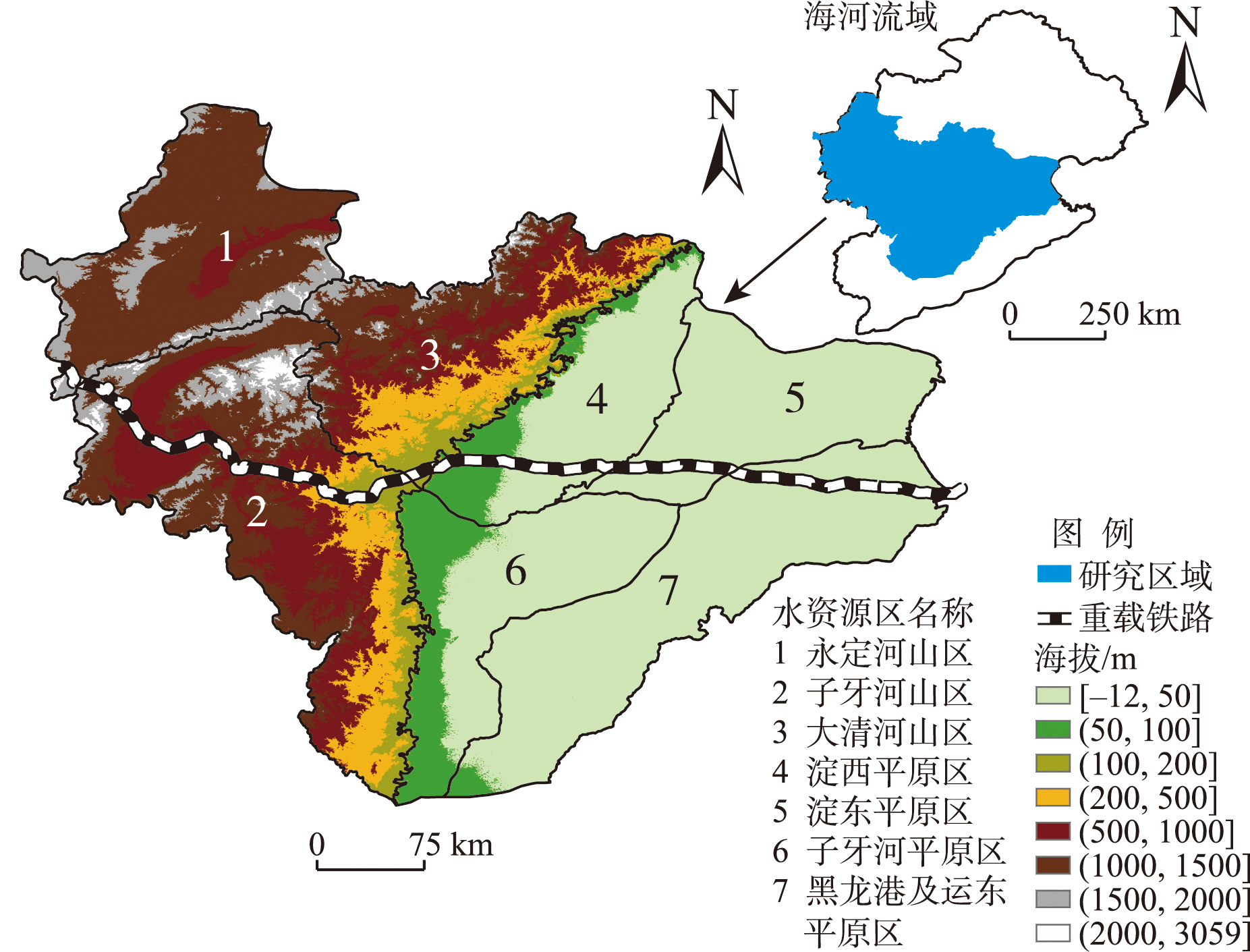
Precipitation is a key disaster-causing factor of flood disasters. Analyzing the spatiotemporal differentiation characteristics and influencing factors of precipitation in the sub-basins of the Haihe River and along the heavy-haul railways is of great significance for ensuring regional flood risk reduction and maintaining railway transportation safety. Based on the daily precipitation data (1960-2023) from the China Meteorological Administration, this study selected four indices—annual precipitation, extreme precipitation (R95pTOT), maximum one-day precipitation (Rx1day), and heavy precipitation days (R10)—to analyze the spatiotemporal differentiation characteristics of average and extreme precipitation along the heavy-haul railways in the Haihe River Basin. The Sen's slope estimator, Mann-Kendall test, and GIS spatial analysis were employed to examine precipitation trends and patterns. Then, the optimal parameters-based geographical detector method was employed to quantify the driving forces of topographic factors (elevation, slope, aspect), land-use change, and Normalized Difference Vegetation Index (NDVI) on precipitation spatial heterogeneity. The influence of atmospheric circulation factors on precipitation characteristics in the study area was also examined. Finally, based on the historical flood records, the risk of disasters induced by rainfall was evaluated. The results indicate that over the 64 years from 1960 to 2023, the R95pTOT and Rx1day in the study area showed a decreasing trend, while the annual precipitation and R10 had increased. All the sub-basins exhibited a two-phase variation characteristic in precipitation, with both average and extreme precipitation demonstrating a significant upward trend after 1997. Notable differences were observed between the western mountainous and eastern plain sub-basins. The spatial heterogeneity of precipitation indices generally followed a "high in the east, low in the west" and "increasing in the west, decreasing in the east" pattern. Terrain-related factors, particularly elevation and slope, exhibited a globally explanatory power in the spatial variation of precipitation characteristics across sub-basins of the Haihe River Basin, with elevation demonstrating the highest overall influence and the significance was markedly higher for the zones along the heavy-haul railways than for Haihe River sub-basins. The Western Pacific Subtropical High represented the primary atmospheric circulation factor influencing precipitation characteristics in the Haihe River sub-basins. Under the background of climate change, significant flood risks exist along railway corridors. These findings provide a scientific reference for flood prevention and disaster mitigation in the Haihe River Basin and for the heavy-haul railway projects.
The accurate identification and prediction of flood behavior variability in small mountainous catchments are of great significance for the risk management of flash flood disasters. In this study, seven flood behavior indicators were selected to characterize the magnitude, timing, form, and rate of change of flash flood events. Principal component analysis (PCA), partitioning around medoids (PAM) clustering technique, random forest, and five-fold cross validation were integrated to identify typical flash flood types and their driving factors, and evaluate prediction performances of flood behavior indicators of various flood types. A total of 94 flash flood events in six small mountainous catchments with different hydro-climatic and underlying surface conditions were selected for the case study. The results show that: 1) All the flash flood events can be clustered into three typical types, including Type 1 with low peak flow intensities, early peak flow occurrence times, long duration of high flow rates, and rapid flood rising and declining rates (50.0%), Type 2 with late peak flow occurrence times and non-concentrated flood processes with gentle variability (31.9%), and Type 3 with high peak flow intensities, short duration of high flow rates, concentrated flood processes with dramatic variability, and slow flood rising and declining rates (18.1%). 2) All flood behavior indicators in Type 1 and Type 3 floods were dominantly governed by the combined effects of rainfall and catchment characteristics, and 57.1% of flood behavior indicator changes in Type 2 floods was mainly governed by rainfall variability. 3) The overall prediction performances of flood behavior indicators in Type 3 flood showed the highest accuracy, followed by those in Type 1 and Type 2. The flood behavior indicators depicting magnitude, timing, and form were more accurately predicted than the rate of change indicator for all three flash flood types. This study is expected to provide a technical support and reference for differentiated prevention and risk management of flash flood disasters.
Flooding is one of the most severe natural hazards in the Haihe River Basin, posing significant threats to infrastructure, transportation, personal safety, and property. Scientifically identifying flood hotspots and conducting sensitivity analysis of key factors are of great importance for regional disaster prevention and mitigation. Based on the Global Surface Water dataset, this study extracted flood frequency and integrated 12 disaster-forming environmental factors: elevation, slope, aspect, Stream Power Index (SPI), Topographic Wetness Index (TWI), surface roughness, slope of slope, soil bulk density (BD), clay content, sand content, organic content, and Normalized Difference Vegetation Index (NDVI). Using spatial autocorrelation and spatial clustering methods, areas with high-frequency flood clustering were identified as hotspots. The random forest model and the optimal parameter-based geographical detector (OPGD) were employed to quantitatively assess flood frequency and analyze disaster-forming environmental factors in the Haihe River Basin. Finally, flood susceptibility was evaluated. The results indicate that: 1) Four main flood hotspots can be identified in the Haihe River Basin, encompassing the Beijing urban area, the Bohai Sea coast, mountainous valley areas, and regions along the G4 Expressway. 2) Both the random forest model and the OPGD consistently indicate that among the selected disaster-forming environmental factors, NDVI and elevation are two important factors influencing the flood occurrence frequency in the Haihe River Basin, with their explanatory power significantly higher than that of other disaster-forming environmental factors. 3) The sensitivity to factors of the disaster-forming environment varies across the four flood hotspots. From the perspective of single-factor analysis, NDVI exhibits a relatively high sensitivity; from the perspective of two-factor analysis, the pairwise interaction between soil property factors and the vegetation coverage factor enhances the explanatory power for flood occurrence frequency. The research results can provide a scientific reference for targeted flood control in the Haihe River Basin.
Flash floods in small mountainous watersheds are characterized by sudden occurrence and highly nonlinear hydrological responses, which pose significant challenges to individual hydrological models. These challenges include inadequate process representation, accumulation of systematic biases, and substantial predictive uncertainty. To enhance the simulation accuracy of flood events in such watersheds, this study developed an integrated framework entitled multi-model modeling-secondary correction-ensemble simulation. This framework synergistically combines a hybrid runoff model (MIX_HM) integrating saturation-excess and infiltration-excess mechanisms, a time-variant gain model (DTVGM), and a long short-term memory (LSTM) neural network model. A secondary correction strategy, employing quantile mapping and LSTM-based residual error correction, was applied to the model outputs. The proposed framework was implemented and validated in the Yangwu River small watershed, a headwater catchment of the Hutuo River, where it was used to simulate 38 flood events from 2006 to 2021. The key findings are: 1) During the calibration period, the LSTM model achieved a Nash-Sutcliffe efficiency (NSE) of 0.73, which remained at 0.63 during the validation period. showed superior performance compared to the MIX_HM model (calibration: 0.56, validation: 0.41) and the DTVGM model (calibration: 0.51, validation: 0.37). Although LSTM demonstrated the best overall performance among the three models, it exhibited a systematic underestimation of peak flows. 2) The residual joint correction method effectively reduced systematic model bias and improved simulation accuracy, with the most pronounced improvements observed in the process-based models (MIX_HM and DTVGM). The NSE values for MIX_HM, DTVGM, and LSTM during the validation period increased by 93.3%, 103.5%, and 21.2%, respectively. 3) The ensemble simulations yielded NSE values of 0.80 and 0.79 for the calibration and validation periods, respectively. This represents a further improvement of 2% and 3% over the post-correction single best model (LSTM). Furthermore, the 90% confidence intervals provided by the ensemble demonstrated a high coverage rate. The results confirm that the proposed multi-model ensemble framework significantly enhances the reliability and accuracy of flood simulation in mountainous small watersheds.
Under climate warming, the frequency and intensity of floods in mountainous areas of inland river basins have exhibited an increasing trend, posing a serious threat to downstream regions. Although the traditional Soil and Water Assessment Tool (SWAT) model possesses the capability for hourly-scale runoff simulation, its representation of snow and ice melt processes remains a weakness, limiting its applicability for flood simulation in cold and alpine basins. To address this problem, this study improved the snowmelt algorithm and glacier ablation module of the traditional SWAT model based on the formation mechanisms and process characteristics of snow and glacier meltdominated floods, leading to the development of an hourlyscale flood forecasting model, SWAT-HGL. The applicability of the proposed model for flood simulation in highaltitude cold regions was validated using typical flood events in the headwater region of the Yarkant River in 2017, 2019, and 2024. The results show that the simulation accuracy of SWAT-HGL is significantly higher than that of the traditional SWAT model, with a Kling-Gupta Efficiency (KGE) exceeding 0.7 for hourly runoff simulation, and percent bias and peak flow bias reaching 3.29% and -6.43%, respectively. The improved model accurately reproduced the rising limb of the flood hydrograph, with a peak occurrence timing error of less than 6 hours. In addition, SWAT-HGL demonstrated high robustness under different meteorological forcing schemes. A simulation time step of 5-7 hours was identified as optimal for SWAT-HGL, providing a balance between the detailed representation of flood processes and computational efficiency. The findings of this study provide an important support for flood control and disaster mitigation, safe operation of hydropower systems, and efficient utilization of water resources.
Satellite-based precipitation products have been widely applied to compensate for the sparse distribution of ground rain-gauge stations due to their wide spatial coverage and strong spatiotemporal continuity. However, they still exhibit systematic biases in regions with pronounced underlying surface changes. Existing precipitation correction methods do not fully account for surface characteristics such as land use, and ignore spatial autocorrelation between adjacent stations, making it difficult to accurately represent regional heterogeneity in terrain and climate. In this study, we developed a spatially enhanced XGBoost precipitation correction model by integrating land use types, precipitation information from neighboring stations, conventional meteorological variables (relative humidity, air temperature, and wind speed), and topographic factors (elevation, latitude, and longitude). The Haihe River Basin was selected for case study. The results show that the XGBoost model improved the accuracy of the IMERG satellite precipitation product in both mountainous and plain areas. The corrected precipitation showed good agreement with gauge observations in terms of both spatial distribution and daily precipitation processes, effectively capturing the evolution of local heavy rainfall events and alleviating the systematic overestimation inherent in the IMERG product. Land use was identified as the dominant factor in improving correction accuracy with the contribution rate of 57.8%-66.7%, characteristic factors such as land use, precipitation, and meteorological factors in adjacent areas contributed more than local information at a single station, and land use exhibited a 9.7%-14.5% higher contribution rate. This study provides methodological insights and a technical support for improving regional precipitation correction models and advancing multi-source precipitation data fusion applications.
With the advent of the information age, human society has progressively evolved into a ternary space encompassing physical space, social space, and information space. This ternary-space perspective offers a novel conceptual lens for urban flood modeling research, providing new pathways to uncover the inherent interdisciplinarity and complexity of urban flood systems. This study investigated two fundamental scientific questions: 1) how to conceptualize urban flood systems through a ternary space framework; and 2) how to establish an integrated geographic modeling paradigm that enables coordinated interactions between these three spaces. To address these questions, this study conducted a comprehensive review of the current research landscape across multiple dimensions, including physical urban flood models, social perception of urban flood events, and information technology-driven approaches to flood modeling. The analysis further refined the definition and connotations of the ternary space construct in the context of urban flooding, identified key challenges associated with geographically integrated modeling, and systematically synthesized the fundamental knowledge-data-model elements underpinning a ternary space-oriented analytical framework. Based on these insights, the study proposed a comprehensive research framework for geographically integrated modeling of urban floods. This framework integrates theoretical support systems, data infrastructure, and methodological approaches, and emphasizes three key research priorities: 1) extraction and integration of spatiotemporal information from multimodal data sources; 2) development of comprehensive urban flood models; and 3) intelligent hybrid computing that facilitates coordination across physical, social, and informational spaces. Finally, this study delineated future research directions, including the in-depth analysis of interaction mechanisms across the three spaces, the restructuring of computational paradigms for flood modeling, and the establishment of robust frameworks for uncertainty assessment. Collectively, these efforts aim to advance a systematic paradigm for urban flood modeling and to enhance the theoretical foundation and methodological repertoire of geographic science in addressing the complexity and dynamics of urban flood processes.
In the context of rural revitalization and the digital China strategy, this article innovatively proposed the concept and theoretical framework of "coupled human and natural digital cube" (CHNDC) for rural modernization in response to the theoretical gap in the coupling system coordination and digital element integration of rural production and living systems. By embedding digital technology as the core element into the coupled cube, the system reveals the four-dimensional mechanism of short-term and long-term coupling in the temporal dimension, close-range and long-range coupling in the spatial dimension, explicit and implicit coupling in the representation dimension, and internal and external coupling in the subject dimension of digitalization. We constructed the CHNDC that combines Chinese style rural modernization with production and living synergy, elucidating the core paths of digital twins eliminating spatial barriers, platform algorisms restructuring data assets, and governance platforms coordinating diverse subjects. Ultimately, we proposed a production and living co-prosperity ecosystem with data element circulation as the link and digital governance community as the carrier, providing theoretical tools for solving the production stagnation and spatial hollowing in rural areas, and promoting the transformation of geographical research towards a dynamic coupling paradigm.
Since the 1970s, globalization, driven by economic efficiency and cost advantages, has integrated regional industries into a highly interconnected system. With the escalation of geopolitical decoupling, particularly in the context of China-U.S. tensions, this system is undergoing profound restructuring. To shed light on emerging trajectories of regional industrial development, it is necessary to synthesize recent scholarship on the impacts of external dynamics under the construction and reconstruction of global value chains and production networks. This study first clarified the connotation and practical manifestations of external dynamics. Furthermore, drawing on the theoretical foundations of evolutionary economic geography and global production network approaches, it identified the main analytical perspectives and conceptual frameworks for studying external dynamics. Accordingly, external dynamics were categorized into external coupling and external decoupling. These two perspectives provide a systematic framework for analyzing the key relationships between external dynamics and regional industrial development under the ongoing global (re)structuring processes. Existing studies suggest that external coupling enhances regional development, particularly by fostering economic growth. By contrast, the consequences of external decoupling remain less clear. On the one hand, decoupling may weaken mechanisms such as knowledge spillovers and innovation diffusion; on the other hand, it may stimulate regionalization and localization of industrial development. Future research could focus on the complex interactions between external dynamics, the domestic circulation, outward opening-up, and regional industrial development, thereby providing policy-relevant insights to support China's transition toward a higher level of institutional opening-up and economic transformation. By consolidating insights from recent studies, this study sought to advance dialogue at the intersection of external dynamics and regional industrial development.
Against the background of integrated urban-rural development and market-based allocation of factors, the flow of urban-rural factors has become a key pathway to breaking down the urban-rural dual structure. Its multi-scale transmission mechanism holds significant implications for promoting coordinated regional development. While current research has made progress in expanding the scope of factors and analyzing driving mechanisms, it still shows notable deficiencies in systematically integrating the multi-scale transmission mechanisms. This study adopted a multi-scale transmission perspective to systematically review existing research on urban-rural factor flows. Integrating scale restructuring theory, flow space theory, and spatial interface theory, it constructed an integrated analytical framework of "scale restructuring-flow-interface interaction". The study revealed that: (1) Existing research on urban-rural factor flows exhibits discontinuities across three dynamic transmission segments—national-regional strategy, regional-local interface, and local-community behavior—preventing the closure of the strategy-behavior-feedback transmission loop; (2) Examination of institutional and geographical interface barriers often treats them as static backgrounds, lacking dynamic and coupling analysis; (3) Top-down and bottom-up processes in scale transmission effect studies remain disjointed. Based on these findings, this article proposed a technical deepening pathway centered on flow-interface-transmission simulation. By integrating factor classification flow measurement, interface assessment, and cross-scale simulation, future research can achieve dynamic deduction from micro-level behaviors to macro-level patterns. This approach provides systematic theoretical tools and methodological support for resolving the scale dilemma in urban-rural factor flows and advancing integrated urban-rural development.
The uneven spatial and temporal distribution of water resources has become a significant bottleneck impeding sustainable regional development. This issue is exacerbated by the dual impacts of climate change and increased human activities, which intensify conflicts between water supply and demand. This article provides a comprehensive review of the historical development and current frontiers of methods for the optimal allocation of water resources, which are essential for effective integrated watershed management. The review systematically explored the topic through three primary dimensions: objective functions, constraints, and solution methods. The results indicate a substantial shift in objective functions — initially focused on purely economic outcomes, they have gradually incorporated a broader set of goals that include ecological, social, and economic objectives. This represents a transition towards a more holistic and sustainable framework for water resource management. Likewise, the development of constraints has evolved from conventional rigid constraints to more flexible "soft constraints" that reflect current institutional and policy landscapes. This evolution underscores an advanced understanding of the socio-political nuances influencing water distribution and utilization. In terms of solution methods, a significant diversification is evident. The field has progressed from relying solely on deterministic mathematical programming to adopting a variety of advanced techniques, such as intelligent optimization, fuzzy and stochastic optimization, and coupled simulation models. These innovations enable more robust modeling of the complexities and inherent uncertainties in water resource management systems. Despite notable achievements, challenges remain, including refining mechanisms for multi-objective coordination, enhancing the quantitative representation of soft constraints, and improving both the physical consistency and interpretability of models. The conclusion underscores the need for dedicated future research to address these critical issues, which are pivotal for advancing water resource optimization and achieving more effective and sustainable management outcomes.
The concept of new quality productive forces represents a distinct Chinese-style theoretical interpretation of Marxist advanced productive forces in the context of the new era. It also embodies a "Chinese solution" for translating Marxist theories into practice—aiming at promoting high-quality development, advancing Chinese-style modernization, and realizing the great rejuvenation of the Chinese nation—thereby underscoring its profound strategic significance. Grounded in disciplinary thinking, this article offered a theoretical interpretation and logical reflection on the geographical thinking and spatial logic of new quality productive forces in the new era. It further explored their practical pathways and responsive strategies in Northeast China under the orientation of the national framework of the "five major securities". The findings indicate that: 1) New quality productive forces embody the essential attributes of Marxist advanced productive forces and serve as an important tool for promoting high-quality urban and regional development. Their evolution follows the geographical logic of the temporal evolution view, human-environment coordination view, regional differentiation view, and industrial embodiment view. 2) The essence of new quality productive forces lies in the transformation from a mere technological tool attribute (means of production) toward serving and realizing urban-regional functional objectives (development goals). Within this process, industry acts as the core carrier, and the spatial realization of new quality productive forces follows a progressive, place-based logic of "problem identification→spatial restructuring→new industrial construction". 3) In the case of Northeast China, the development of new quality productive forces should be guided both by the strategic imperatives of the national "five major securities" and by the constraints of regional conditions and resource endowments. Following the same spatial logic of "problem identification→spatial restructuring→new industrial construction", this study systematically considered development approaches and policy strategies from the perspectives of both the overall region and its differentiated city types. Finally, the study emphasized that not all cities are equally suited for homogeneous development of new quality productive forces. Their advancement must align with local resource endowments and locational advantages, with industry serving as the practical carrier. By integrating the geographical perspectives of temporal evolution, human-environment coordination, regional differentiation, and industrial embodiment into the economic interpretation of the "advancement" of new quality productive forces, this research proposed a new paradigm for their spatial realization and materialization, offering theoretical insights for the revitalization and high-quality development of Northeast China.
In the context of the global technological revolution, artificial intelligence (AI) technology has emerged as a key driver of economic growth, with China leading the world in AI patent filings for five consecutive years, according to the World Intellectual Property Organization (WIPO) report. However, significant disparities in innovation levels persist across regions, and the level of collaborative innovation between regions still lags significantly behind that of developed countries. Inefficient and constrained channels for knowledge spillover are key limiting factors. This study focused on the Yangtze River Economic Belt as the research area. We selected 108 prefecture-level and above cities within this region as research objects to construct a city-level AI innovation cooperation network for the Yangtze River Economic Belt. Using social network analysis (SNA) and the exponential random graph model (ERGM), we examined the evolutionary characteristics of the network and analyzed the role of knowledge spillover in the development of the AI innovation cooperation network, incorporating city attributes, geographical proximity, and administrative proximity. The findings reveal the following key insights: 1) Evolution of Network Structure: Social network analysis indicated that the AI innovation cooperation network in the Yangtze River Economic Belt had evolved from a unipolar structure to a multi-polar balanced structure. Empirical analysis using the ERGM further confirmed that innovation resources such as knowledge and skills within the region were diffusing beyond their original boundaries, although core cities continued to dominate the pathways of knowledge spillover and maintain central positions in the network. 2) Knowledge Spillover's Driving Role: Knowledge spillover consistently played a crucial promoting role in the development of the innovation cooperation network, with its mode of influence transforming as the network evolves. Empirical analysis of the Yangtze River Economic Belt as a whole and its sub-regions revealed that in the early stages of AI development, knowledge spillover facilitated the formation of collaborative relationships. As the number of nodes and relationships grew, the effect of knowledge spillover somewhat diminished, but it remained a core influencing factor for the cooperation network. 3) Network Structural Evolution Trends: The network structure of AI innovation cooperation in the Yangtze River Economic Belt exhibited specific evolutionary trends. Overall, core-periphery structures and "closed triadic" structures significantly promoted network formation, while "open triadic" structures inhibited it. Specifically, regions in the early stages of AI development are more prone to forming core-periphery structures. As the number of nodes and relationships increases, the role of this structure gradually weakens, while the promoting effect of closed triadic structures becomes more pronounced. 4) Spatiotemporal Heterogeneity and Regional Development: Heterogeneity analysis showed that the impact of knowledge spillover on the AI innovation cooperation network exhibited significant spatiotemporal heterogeneity, and different regions displayed distinct endogenous network structure evolution characteristics. In the upstream region, the knowledge spillover effect became explicit after 2016, forming a core-periphery network structure. In the midstream region, the knowledge spillover effect is more pronounced, resulting in a hybrid network structure where direct cooperation and indirect cooperation coexist. In the downstream region, the knowledge spillover effect, while persistently significant, gradually faded away, leading to a polycentric network structure where cities are more likely to engage in direct rather than indirect cooperation.
Fostering emerging industries and accelerating the transition between old and new growth drivers are crucial for achieving high-quality economic development and enhancing international competitiveness, therefore it is necessary to deeply understand regional new industrial paths and its driving mechanisms. Taking the development zone, a fundamental unit derived from new industries, as the research object, an analytical framework was established for external linkages, endogenous processes, and new industrial paths. By quantitatively analyzing the enterprise registration data through the location quotient method, standard deviation ellipse method, and industrial linkage analysis method, and combining the qualitative materials obtained from field research, this study explored the path development and driving mechanisms of industrial evolution in the development zones of Jiangsu Province. The research revealed that the industrial evolution of development zones has undergone three stages: the implantation of local paths under the impact of globalization, the implantation of global paths under multi-scale links, and the diversified development of paths under endogenous innovation. As development zones evolved, the effect of external linkages shifted from path shaping in the early stages to path triggering in the later stages. Simultaneously, the focus of endogenous processes transitioned from absorption and learning to recombination and innovation. The synergistic evolution and interaction of these two aspects constituted the core driving mechanism for industrial diversification in the development zones. This study revealed the intrinsic logic of industrial catch-up and upgrading in China at the scale of development zones. It also enriched evolutionary economic geography's understanding of the paths and mechanisms of industrial evolution in emerging economies, thus providing insights for promoting regional industrial transformation and upgrading in the new era.
The spatial and temporal imbalance in the allocation of urban healthcare resources represents a major challenge to the implementation of the "Healthy China" strategy. Identifying dynamic changes in healthcare accessibility and their equity implications is crucial for optimizing healthcare resource distribution. Addressing the research gaps in quantifying the spatiotemporal coordination of multi-modal transportation and assessing the dynamic equity of accessibility across multiple time periods, this study developed a comprehensive evaluation framework. This framework integrates the Criteria Importance Through Intercriteria Correlation (CRITIC) weighting method, an enhanced two-step floating catchment area (2SFCA) method, and a time-based Gini coefficient. A case study of the main urban area of Kunming City was conducted, utilizing multi-period real-time traffic data to measure healthcare accessibility under both driving and subway-dominated public transport modes. The Multi-mode Accessibility Gap (MAG) index was employed to quantify the coordination between these two modes. The findings reveal three key points. First, the spatial pattern of healthcare accessibility is characterized by "central radiation with distance decay" for driving and "fragmentation along subway lines" for public transport. Second, reducing the time threshold significantly intensifies the spatial agglomeration of resources, as indicated by a time-based Gini coefficient reaching up to 0.968, which highlights substantial equity concerns. Third, the MAG analysis demonstrated a failure of modal complementarity in both the urban core and peripheral areas. The proposed framework offers a novel perspective for understanding the spatiotemporal equity of healthcare resources. It also provides a methodological reference for optimizing resource allocation in other similar cities.
Mountainous areas account for more than two-thirds of China's land area, and their complex geographical conditions pose significant challenges to disaster emergency response. To address the low response efficiency and insufficient service coverage of existing emergency rescue networks in mountainous regions, it is essential to construct networks that balance redundancy and efficiency. This study took the western mountainous areas of Beijing and surrounding townships as the study area and developed a multi-objective optimization model under limited resource conditions. The model simultaneously minimizes three objectives: maximum response time, population-weighted average response time, and maximum backup response time. A redundancy constraint requiring each township to be covered by at least two Emergency Rescue Centers (ERCs) is incorporated, together with facility capacity constraints and service disparity control. The model is solved using the NSGA-II algorithm to derive optimal network configurations. Travel time estimated from online map services during typical peak-hour periods and township-level census population data are used as empirical inputs. To evaluate the stability of the optimization results, each scenario is independently solved using 30 different random seeds, and the resulting solution sets are examined via the Kruskal-Wallis non-parametric test. Four comparative scenarios are designed: the baseline network comprising 13 existing ERCs (G1), and three scenarios involving the addition of a single ERC at Zhaitang Township (G2), Donghuayuan Township (G3), and Sanpo Township (G4), respectively. The optimization results are analyzed through Pareto front comparison and scenario-based evaluation, focusing on response efficiency, redundancy performance, and network structural characteristics. The results indicate that G2 (Zhaitang) primarily strengthens redundancy coverage in deep mountainous areas by expanding backup service pathways, thereby enhancing service equity. G4 (Sanpo) achieves the most substantial reduction in maximum response time, decreasing it by 23.1% relative to the baseline, and demonstrates the strongest robustness under ERC-failure scenarios. G3 (Donghuayuan) yields comparatively limited improvement across all evaluation dimensions. Furthermore, network structure analysis reveals that although adding new ERCs does not fundamentally alter the overall network backbone, the strategic placement of new nodes can effectively reshape the redundancy-efficiency trade-off boundary. This study demonstrates that targeted node addition to an existing network constitutes a key pathway for enhancing system resilience and provides an extensible methodological framework for optimizing emergency rescue network configurations in mountainous regions under complex terrain conditions.