
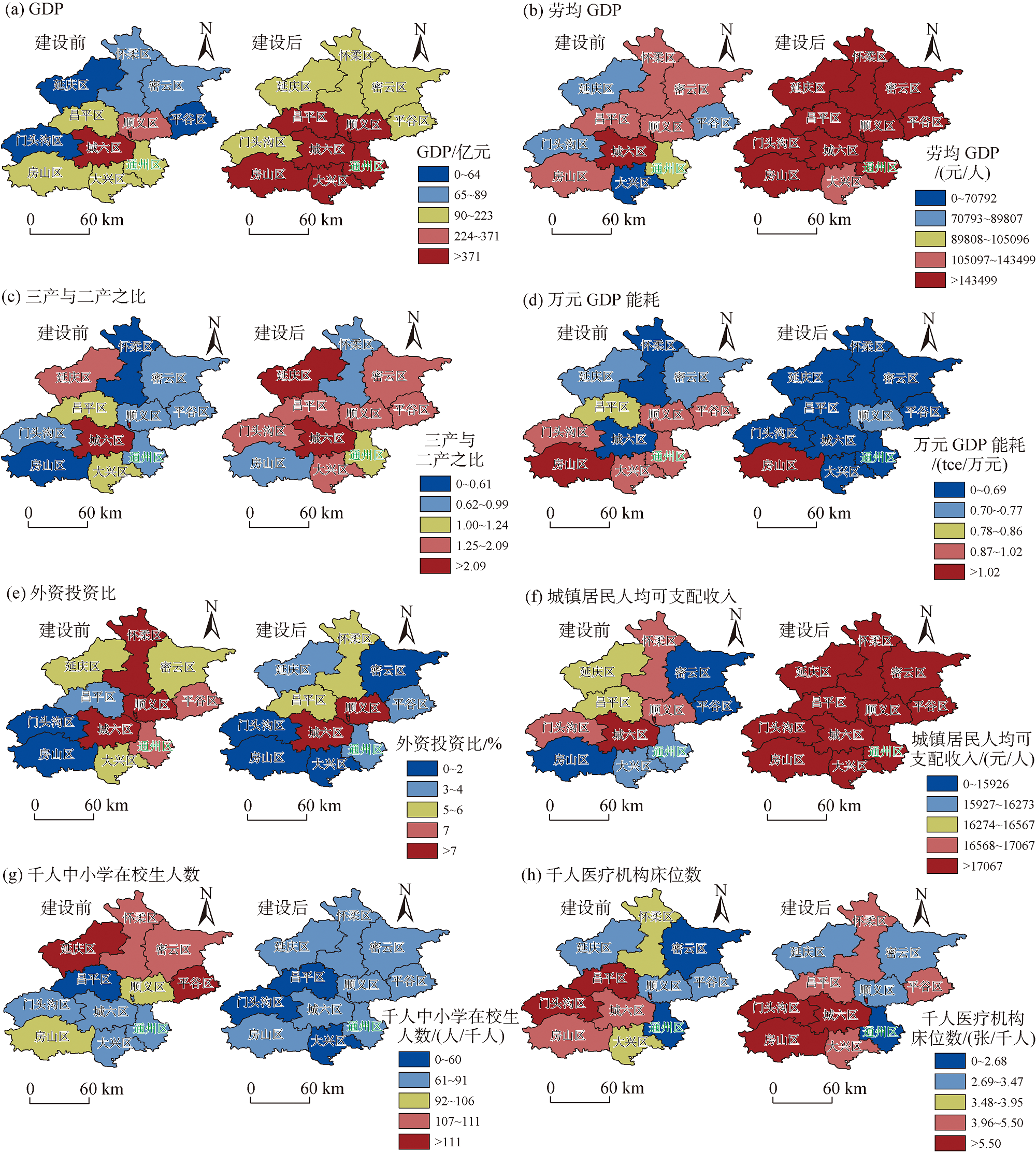
The development of the urban sub-center in Tongzhou District, Beijing involves new city planning and construction that include the relocation of the city's administrative centers. While reshaping the spatial pattern, it also bears the responsibility of high-quality development demonstration. By using the synthetic control method and the panel data from 2002 to 2020, this study examined the impact of Beijing's sub-center construction on the high-quality development of the relocation area from the five dimensions of innovation, coordination, greenness, openness, and sharing. The results show that the construction of the sub-center has improved the output efficiency of Tongzhou, promoted energy conservation and emission reduction, but reduced the level of medical service supply. The development had no significant impact on the improvement of industrial structure, the utilization of foreign investment, the increase of residents' income, and the increase of education service supply. These heterogenous results indicate that observing high-quality development from different dimensions is more comprehensive than simply evaluating the total economic output. Targeted measures should be taken to address the changing characteristics of different dimensions of high-quality development. First, infrastructure, population migration, industrial planning, and public services should be matched to improve the level of public service supply. Second, the new sub-center should quickly improve the level of modern service industry to provide support for the upgrading of its industries. Third, the sub-center should fully leverage its role as a window for opening up to the outside world, providing a benchmark of openness for other regions.
Administrative division adjustment as an institutional support for spatial governance is an important measure to optimize resource allocation, and it has profound effects on promoting balanced regional development. Based on the panel data of 272 cities in China from 2013 to 2021, this study used the spatial difference-in-differences method to explore the impact of district-level administrative restructuring, a special type of administrative division adjustment, on balanced regional development, and further analyzed the mediation mechanism of urban morphological polycentricity. The results show that district-level administrative restructuring is not only beneficial to promoting balanced regional development in local regions, but also has positive spatial spillover effects on neighboring regions. Mechanism analysis show that under the background of administrative division adjustment, urban form is an important driving factor for balanced regional development. Specifically, district-level administrative restructuring can reduce regional development inequality by improving the level of urban morphological polycentricity. Heterogeneity analysis show that the impact of district-level administrative restructuring on balanced regional development varies across regions. Compared to the western region, the positive effects of such restructuring on balanced regional development are more significant in the eastern and central regions. The restructuring has significant promotional effects in large cities and medium-sized cities, while the effects in mega-cities, super-large cities, and small cities are not significant. In the future, we should prudently carry out administrative division adjustment and urban spatial transformation according to the development conditions of different cities, and promote the construction of urban polycentricity by district-level administrative restructuring according to local conditions, in order to promote balanced regional development.
High-quality cultivation of specialized and sophisticated enterprises that produce new and unique products is an important starting point for consolidating the security foundation of China's industrial chain and supply chain. Using buffer zone analysis and the multi-scale geographically weighted regression (MGWR) model, this study explored the spatial distribution of specialized and sophisticated enterprises that produce new and unique products in the Yangtze River Delta region and influencing factors in 2021. The study found that: 1) Spatially, Shanghai is the main area where specialized and sophisticated enterprises that produce new and unique products are concentrated, followed by provincial capitals and cities on the coast and along rivers; The overall composition of the industry is unbalanced, and the real economic industries such as machinery and equipment manufacturing and high-tech manufacturing account for a relatively high proportion, but there are differences in different regions. 2) In terms of spatial agglomeration, differences between circles and the scale effect are obvious. Within each province, the spatial distribution of specialized and sophisticated enterprises that produce new and unique products in different cities is uneven. Region-wide, the overall spatial distribution pattern of "one pole and multiple cores" is evident. Shanghai is the main agglomeration area for these enterprises, and the provincial capital cities and cities that are the regional economic centers are the secondary agglomeration areas of these enterprises. 3) The four dimensions of influencing factors—physical geography, government, market, and society—have a scale effect on the spatial distribution of specialized and sophisticated enterprises that produce new and unique products. The degree of land development acts at a small scale, which is a local variable, and shows a large difference in the impact on the spatial distribution of these enterprises across the region. Factors such as elevation, government-business relationship, degree of marketization, number and scale of enterprises, degree of openness, logistics development level, and innovation environment are global variables, and except that the degree of marketization and the number of enterprises have a significant negative impact on the spatial distribution of these enterprises, the impact of all other factors is significantly positive. The research results can provide support for the optimization of the layout of new special expertise enterprise space in the Yangtze River Delta region, in order to provide reference for the formulation of new special expertise policies and industrial planning.
The implementation of the expressway new infrastructure project, integrated with an online toll collection system, has significantly advanced the intelligent development of expressways. It also improves the availability of a highly accurate digital map for analyzing the spatial and temporal characteristics of traffic flows. This study used the extensive dataset of origin-destination (O-D) traffic flows, obtained from the online toll collection system. By employing techniques such as big data mining and geospatial analysis, the study investigated the distribution patterns of expressway traffic flows at various scales and by different types in Guangdong Province. The ridge regression method was employed to identify the primary factors that influence traffic flows. The results are as follows: 1) It is evident that vehicles on the expressway in Guangdong exhibited notable characteristics of miniaturization and light weight. The passenger travel on expressways was predominantly reliant on cars, while the utilization of public transport (buses) was relatively low. Freight structure was primarily dominated by light-duty trucks. From a spatial perspective, the distribution of expressway traffic flows in Guangdong exhibited the characteristics of spatial unevenness. The road sections with high traffic flows were concentrated in the Pearl River Delta urban agglomeration, forming a distinct pattern of "double beltways" with the Guangzhou ring expressway and the Guangzhou bypass expressway as central hubs. This distribution pattern showed a radial diffusion feature, with traffic flows spreading outward along national expressways from central hubs towards the periphery. 2) The expressway traffic flows in Guangdong demonstrated a temporal variation characterized by a "hump curve", with the two peaks occurring at 9:00 a.m. and 17:00 p.m. Notably, cars were the most sensitive to changes in time. Among the three types of trucks, those with larger loading scales displayed more stable patterns and exhibited weaker sensitivity to time changes and slower response to fluctuations. 3) The results of ridge regression analysis indicate that the expressway traffic flows in Guangdong were primarily influenced by the vehicle possessing quantity, the level of resident consumption, and the development of the service industries. This study contributes to the expansion of the application of digital new infrastructure systems in the field of geography, while also bearing theoretical significance in enhancing our understanding of traffic activity patterns and enriching the theory of spatial transport links.
Promoting the high-quality development of the Liaoning coastal economic belt is of great significance for the development of Liaoning Province, the revitalization of Northeast China, and the regional cooperation in Northeast Asia. On the basis of clarifying the connotation of high-quality development, this study constructed an evaluation indicator system of high-quality development, and used the entropy weight TOPSIS method to measure the high-quality development level of the Liaoning coastal economic belt from 2006 to 2020. Furthermore, using the improved gravity model, this study explored the spatial connection structure of high-quality development and the division method of gravity pattern, and combined the Wilson model to measure the radiation range of cities with radiation capacity. The results show that: 1) During the study period, the high-quality development level of the Liaoning coastal economic belt showed a slightly fluctuating upward trend, and the spatial difference of development level was significant. 2) The driving factors of the development of each dimension were coordinated development, deepening of reform, and green development. Innovation development, kinetic energy conversion, and shared development showed a spatial differentiation led by Dalian City; green development and coordinated development showed a spatial differentiation of leading development in the Bohai Wing; and opening-up and deepening reform showed a spatial differentiation of leading development in the Yellow Sea Wing. 3) The complexity of the spatial connection network structure is increasing year by year, but it is still necessary to further innovate the coordinated and interactive development mechanism of the three major regions of Liaoning coastal economic belt, Shenyang economic zone, and Northwest Liaoning, to improve the level of urban spatial connection. 4) The Liaoning coastal economic belt presents three types of urban spatial connection structure: external radiation type, external dependence type, and balanced radiation and dependence type. Dalian is the only external radiation city, and the spatial radiation range also shows an outward expansion trend.
With the deepening of the strategy of opening up to the outside world, Chinese financial enterprises have accelerated the pace of entering global markets and continuously improved their global strategic layout. Financial enterprises provide financial support for the global expansion of other industries by setting up global branches, which drives international business exchanges and capital flows, resulting in a network of intercity connections. Based on the analysis method of urban network, this research took the temporal and spatial evolution of the global layout of Chinese financial enterprises as an entry point, and explored the shaping process of the intercity network connecting global cities by Chinese financial enterprises from 1979 to 2019. The study found that: 1) The global expansion of Chinese financial enterprises went through different stages and showed regional characteristics. 2) With the increase in the number and expansion scope of global branches, the Asia-Pacific region, offshore financial centers, and major financial centers in Europe and the United States have become important node areas in the network and the expansion extended from major world cities to small and medium-sized cities around the world. 3) Intercity connections are mainly shaped by three types of expansion models of financial enterprises, namely headquarters-branch, headquarters-regional center-branch, and acquisition expansion. Finally, the study analyzed the influence of national economic strategy, geographical relationship, enterprise attribute, and node region characteristics on the expansion path of enterprises and the formation of intercity connections, and provides scientific reference for the global expansion of financial enterprises and the construction of international financial center cities.
With the transformation and development of the social economic systems, cultural and entertainment experience has gradually become an important indicator to measure the quality of life and actual needs of urban residents. Examining the spatial heterogeneity and scale effect of the influencing factors of cultural and entertainment experience is urgently needed in order to improve the quality of consumer cultural and entertainment experience and promote the optimization of the layout of cultural and entertainment industry. Based on the Meituan review and point of interest (POI) data, and taking bars in Xi'an City as an example, this study divided consumer experience into physical experience and emotional experience and used the multiscale geographically weighted regression (MGWR) model to explore the spatial heterogeneity and scale effect of influencing factors of entertainment experience at different scales. The results indicate that: 1) Bars with high levels of good experience in Xi'an are mainly distributed in Lianhu District and Beilin District. Compared to other areas, there are many bars in Yanta District, but consumer experience in these places is relatively poor. 2) The attributes of merchants, transportation conditions, commercial environment, and location advantages jointly affect the spatial distribution of cultural and entertainment experiences, but their impact intensity and scope vary at different scales. There is a spatial heterogeneity in the influencing factors of entertainment experience. 3) At the city level, the negative impact of high consumption unit price on physical and emotional experiences in the northern part of the city is the most significant. At the grid scale, the store rating, number of reviews, and distance to hotels have the strongest positive impact on physical and emotional experiences in the southwestern part of the city. 4) There is a scale effect of the influencing factors of cultural and entertainment experience. The scale of the impact of the number of reviews, the distance to commercial district, and the distance to the city center on consumer experience is relatively small. The research results can provide important references for optimizing the spatial layout of urban cultural and entertainment industries and making consumer decisions.
Non-grain cultivated land is the key area of cultivated land supplementary source and use control. Realizing the objective of protecting cultivated land in the new era depends on scientifically determining the potential of non-grain cultivated land consolidation and clarifying the differentiated control strategies. Taking the Chengdu Plain as the study area, this study developed a research framework of "connotation definition-potential identification-differentiated control". Based on a systematic analysis of non-grain cultivated land consolidation potential, the theoretical potential of non-grain cultivated land consolidation was clarified by identifying non-grain cultivated land patches and applying relevant resource and environmental carrying capacity and territorial spatial development suitability evaluation methods. On this basis, an evaluation system for the actual potential of non-grain cultivated land consolidation was constructed, which includes planning and control constraints, farming condition constraints, economic support constraints, and societal willingness constraints. Finally, the two-dimensional graph theory clustering algorithm was used to develop the non-grain cultivated land consolidation zoning, and the control strategies were proposed. The results show that: 1) The agricultural production conditions of non-grain cultivated land on the Chengdu Plain are favorable. The theoretical potential area of non-grain cultivated land consolidation is 2461.14 km2, which shows a spatially imbalanced distribution. 2) The coefficients of planning and control constraints, farming condition constraints, economic support constraints, and societal willingness constraints are 0-0.43, 0.25-0.70, 0.18-0.86, and 0.41-0.77, respectively. Correspondingly, the actual potential area of non-grain cultivated land consolidation is 2348.31 km2, 1347.89 km2, 1676.52 km2, and 1292.74 km2. There are significant differences in the actual consolidation potential scale driven by multi-factor constraints. 3) Using the "constraint type + timing" method, the non-grain cultivated land consolidation areas on the Chengdu Plain was divided into five zones. The combination of constraint types and consolidation timing arrangement of different zones determines the differentiated non-grain cultivated land consolidation control strategy. The results of this study provides some scientific support for strengthening the governance of cultivated land non-grain use and ensuring the implementation of the "balanced entering and exiting" system of cultivated land on the Chengdu Plain.
Measuring the intensity of competition for forage between livestock and wild herbivores is important for improving the compensation system of wildlife damage and promoting harmonious human-wildlife coexistence. Using indictors including forage yield, livestock number, and wild herbivores population size, and a combination of grassland quadrat, wildlife transect line survey, and model simulation tools, this study proposed a method to measure the intensity of competition for forage between grazing livestock and wild herbivores, and evaluated the intensity of competition in Maduo County, where more than 3/4 of the county area is within the Sanjiangyuan National Park. The results show that: 1) The population densities of Tibetan wild ass (Equus kiang) and Tibetan gazelle (Procapra picticaudata) in Maduo County were 0.2157 and 0.1655 head/km2, respectively, and their numbers were 5307 and 4073, respectively, in total equivalent to 23264 sheep units (SU), according to the transect line survey in 2022 and random forest model simulation. The number of grazing livestock at the end of 2018 was 342000 SU, and the relative intensity of competition for forage between livestock and wild herbivores was 1/14.7. 2) The edible forage yield of alpine meadow and alpine steppe in Maduo County was 118.7 and 88.3 g/m2, respectively, and the carrying density was 0.2710 and 0.1532 SU/hm2, respectively. The theoretical carrying capacity of grasslands in the county was 528500 SU. The stocking rates of livestock, herbivorous wildlife, and livestock + herbivorous wildlife were 64.7%, 4.4% and 69.1%, respectively. 3) In the townships within the Sanjiangyuan National Park, the stocking rate of domestic livestock was low, the stocking rate of wild herbivores was high, and there was a potential for the grassland to support more wild herbivores, but the relative intensity of competition for forage between livestock and wild herbivores was high. It is recommended to relocate herders from the national park and improve the compensation system for wildlife damage within the national park and surrounding areas. In the townships outside the national park, overgrazing was serious, the stocking rate of livestock was very high, while the intensity of competition for forage between livestock and wild herbivores was not high, therefore it is recommended to reduce domestic livestock and increase the efficiency of animal husbandry.
Rurality in the context of tourism is not only the epistemology of rural grand narrative, but also the methodology leading the practice of rural tourism development. This study analyzed the rural development process from traditional villages, rapid urbanization, to urban-rural integration, reviewed the relevant literature on rurality in China and internationally from the perspectives of rural regional functions, political economy, and overall rural construction, and analyzed rurality in the context of tourism based on the conceptual analysis logic of "element composition-basic attributes-important features". This study proposed that: Rurality in the context of tourism is the local significance of tourism's influence on the human-environment relationship in the process of rural reconstruction. From the perspective of the subjects of demand, it is reflected as tourists' cognition and emotion towards the countryside, and from the perspective of rural development, it is reflected as the result of the practice of rural tourism development carried out continuously by multiple subjects in the context of specific rural regional space. The basic attributes of economy, social and culture, nature and landscape, the regionalism of spatial dimension, the dynamic nature of time dimension, and the experience of value dimension should be understood in the relationship between "I" and "other", urban and rural, modernity and tradition, and commerciality and authenticity. This study constructed a framework of rurality concept analysis in the context of tourism, and put forward the prospect of future research at the levels of research content and methods.
The escalating climate and environmental changes in the Arctic have a series of impacts on the local society and economy. Understanding these impacts from the perspective of the tertiary sector can provide references for the sustainable development of the Arctic and globally, as well as for the participation of non-Arctic countries in Arctic affairs. This study systematically reviewed the literature to identify the pathways and effects of Arctic changes on typical industries within the tertiary sector. The results show that various Arctic changes, such as rising temperatures, increasing precipitation, ice melting, and permafrost degradation, have widely influenced the tertiary sector through multiple pathways, presenting both benefits and challenges for most elements of the industries. These impacts offer several insights for relevant studies and for China. Further research is needed to: 1) address the knowledge gaps regarding the pathways of impacts and comprehensively integrate the beneficial and harmful effects of Arctic changes; 2) explore the indirect and cascading impacts of Arctic changes; and 3) integrate multi-source data for research. China can take advantage of the opportunities presented by the changes in the Arctic tertiary sector by: 1) increasing its participation in Arctic rule-making; 2) improving transportation infrastructure and security of the "Polar Silk Road"; and 3) diversifying Arctic tourism products and creating conditions for trade growth.
The popularization and application of smart technologies such as mobile Internet, Internet of Things, and cloud computing continuously change the matching relationship between supply and demand of urban residential services, having an impact on the efficiency and fairness of the spatial and temporal allocation of urban residential resources. The development of smart technologies also has a reconstruction effect on the spatial layout of urban residential facilities. This study first examined the research progress of the supply-demand relationship of urban residential services under the influence of smart technology application, and put forward a theoretical analysis framework of the supply-demand matching of urban residential services based on the perspective of the human-environment coordinated development in the information era, and the association between virtual and physical spaces. Then, the research prospect is outlined with four aspects. First, we should focus on the matching relationship between supply and demand of urban residential services, under the application of smart technologies, and analyze the characteristics of residents' demand for various online services. Meanwhile, we should examine the supply-demand matching process of residential services and their spatiotemporal interaction model under the application of smart technologies. Second, the mechanism of influence of supply-demand matching could be explored from four dimensions, including service quality and perception, traffic and residents' travel, use of time, and individual social connection. Third, we need to explore the function, spatial layout, and land use changes of urban residential service facilities brought about by the application of smart technologies, and propose new models for urban residential service facility location choice and land use. Finally, towards the development of smart cities in the future, we should propose different configuration strategies of urban residential services according to the differences of urban spaces and facility types. This study has theoretical significance and practical value for the improvement of public service resource allocation efficiency and spatial layout optimization in the development of future smart city.
Accelerating urban-rural integration has seen rural regional systems being more deeply embedded in the global production networks, underlining the increasing importance of sustainable rural development. The recent COVID-19 pandemic as an international public health emergency has once again reiterated the importance of public health. Most studies tend to focus on urban areas in terms of the spread, prevention, and control of the pandemic, as well as resilience improvement of countries and regions while neglecting the integrated effects of the pandemic on vast rural areas. Taking COVID-19 as an example, this study comprehensively reviewed and analyzed 952 publications on the development and evolution of human-earth relationships in rural areas under public health emergencies that were retrieved from the Web of Science database, and identified four research focuses: rural agri-food systems, rural livelihoods response, health and well-being of the population, and urban-rural relationships and governance, which correspond to the four sub-systems of rural human-earth relationships respectively. The review and analysis found that public health emergencies exacerbated the differences between urban and rural systems, revealed the vulnerability of human-earth relationships in rural areas, and led to increased instability in global rural areas. This study is expected to facilitate investigation into global rural development trends in the age of global risk society, improve the understanding of human-earth relationships in rural areas under public health emergencies, and promote urban-rural coordination and sustainability.
Urban and rural memories record and interpret the changes in social forms and cultural structures. They provide insights into human-environment relationships, local cultural spirit, and urban-rural landscape changes, and are an indispensable part of people's lives in their "ideal home". This study used the CiteSpace and VOSviewer visualization software, combined with comparative studies of urban and rural memory research in China and internationally, to explore important research progress and reflect on the development of modern society. The study found that: 1) Urban and rural memory can be divided into commemorative memory, daily memory, and media memory. 2) Urban and rural memory is a multidisciplinary research field. In China, it is mainly focused on disciplines such as architecture, planning, and tourism management, with a clear application direction; while in other countries, it is a comprehensive research field in humanities and social sciences. 3) The ideas and theories of Chinese and international research are consistent, viewing memory as a social heritage. The evolution of international research followed the route of collective memory produced by cultural turn, commemorative memory under official narratives, and daily memory under local customs, with a focus on localities and landscape analysis, emphasizing spatial perception. In contrast, the evolution of Chinese research followed archive construction and memory-urban historical context protection and memory-tourism and memory under the rural revitalization strategy, focusing on people's nostalgia as the entry point. In the future, it is necessary to define the connotations of and differences between urban and rural memory and cultural heritage, pay attention to the memory discourse rights of minority groups, and construct a more comprehensive urban and rural memory space paradigm based on the development of local culture.
Geographical sciences is a discipline that study natural and human phenomenon on the Earth's surface and their interrelationships. As an important component of geographical sciences, disaster geography focuses mainly on the spatial distribution characteristics, disaster-prone environments, and occurrence processes of natural hazards and disasters, providing support for the development of scientific disaster prevention and mitigation strategies. With the continuous deepening of disaster geography research and the gradual strengthening of research teams, the National Natural Science Foundation of China established the secondary application code "Environmental Geography and Disaster Geography" (D0104) for the first time under the discipline of geographical sciences (D01) in 2021. Based on this development, this article summarized the connotation and characteristics of disaster geography, and analyzed the application and funding status of disaster geography-related general projects, young scientist projects, and regional science foundation projects over the past two years. It also discussed the 11 research directions included in disaster geography in conjunction with keywords. The results show that: 1) The establishment of the disaster geography sub-discipline code has optimized the application and funding channels for this discipline, and the number of applications has significantly increased. 2) Disaster geography applications exhibit clustering characteristics, and the scientific problem attributes align with the "demand-driven, breaking through bottleneck" principle, but the attributes are relatively singular. Research capacity is concentrated in the North China region, with the Chinese Academy of Sciences as the main research group. 3) Disaster geography mainly focuses on climate change and related hazards and disasters such as flash floods and debris flows. The types of disasters are relatively singular, and the keyword database needs to be updated and optimized in a timely manner. Research methods and techniques in the discipline are relatively diverse. 4) The coverage of sub-directions of research in disaster geography has been preliminarily clarified, and the majority of applications are in the direction of "disaster risk analysis and management". In summary, disaster geography should enrich the attributes of scientific problems, strengthen the breadth and depth of research content, improve the matching between research directions and project applications based on the construction of research teams with regional characteristics, and promote the development of disaster geography, thereby contributing to the construction of an ecological civilization.