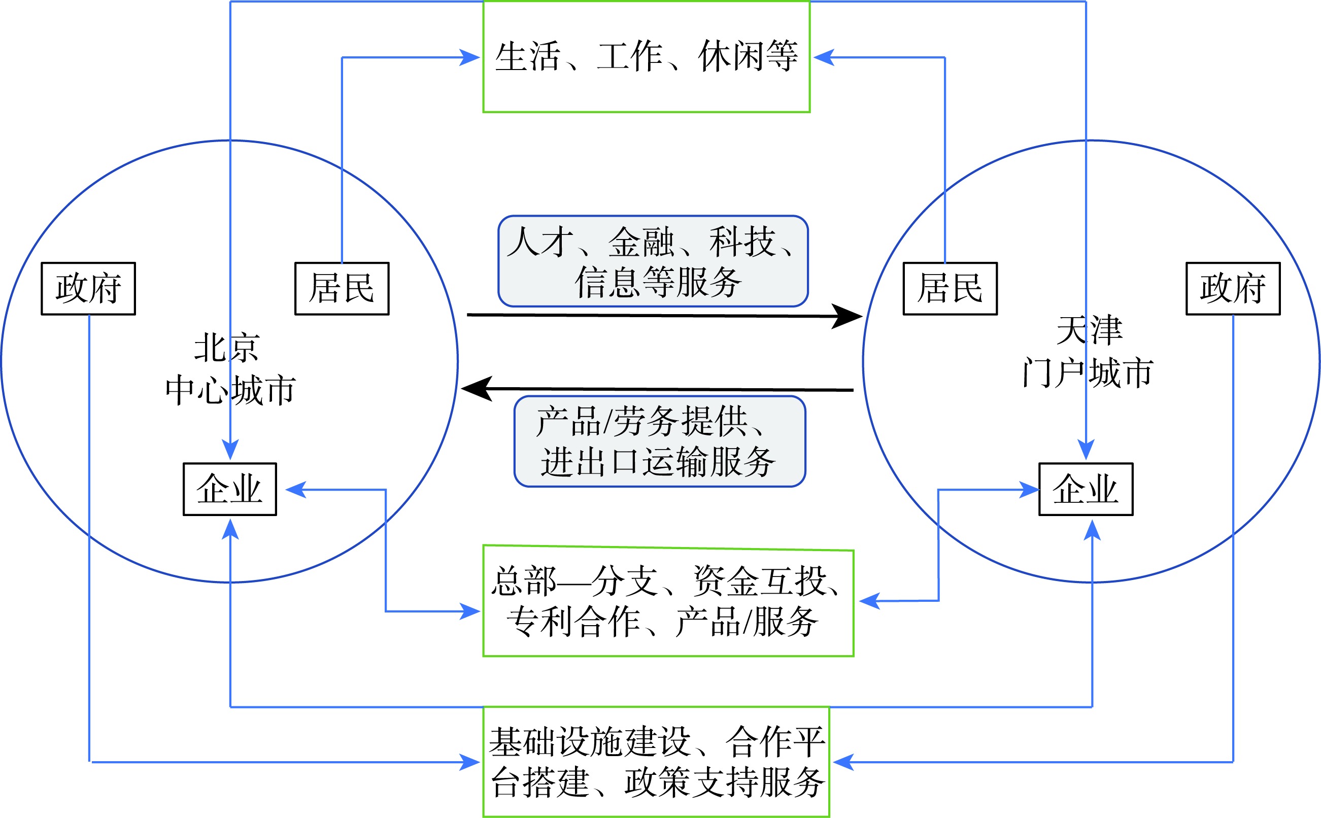
Strengthening the interconnection between Beijing and Tianjin Municipalities is of great significance for promoting the coordinated development of the Beijing-Tianjin-Hebei region and enhancing the competitiveness of the whole region. In order to depict the characteristics of interconnection between Beijing and Tianjin in detail, this study proposed an analytical framework for the interaction of factors between Beijing and Tianjin based on the theory of dual-nuclei structure. According to this framework, the interaction of factors between Beijing and Tianjin can be divided into three aspects: resident population mobility, firm economic factor mobility, and government cooperation platform co-construction. The characteristics of these interactions between Beijing and Tianjin were analyzed by integrating multiple sources of data, including traditional statistical data, big data of mobile signaling, big data of enterprise contact, and field research data. The results show that Beijing and Tianjin have already had significant business cooperation that benefits both cities by combining their strengths. However, compared to Tianjin, Beijing has absolute advantage in most economic development factors, which leads to the deep dependence of Tianjin on Beijing. Tianjin needs to make efforts to enhance the spillover capacity of its advantageous fields to the whole Beijing-Tianjin-Hebei region. Beijing and Tianjin clearly share common understanding of the functional positioning of the two cities, but the characteristics of the interconnection between Beijing and Tianjin show that they still need to further refine their functional coordination and improve the policies and mechanisms on some important links. For example, Beijing should improve its cooperation with Tianjin while conducting its non-capital function dispersion and Tianjin has room for improvement in optimizing its allocation of factors and industrial environment, and actively responding to Beijing's functional positioning. In particular, Tianjin, as a gateway and traditional manufacturing city and a city with advantages in R&D resources, should put more emphasis on responding to Beijing's spillover of talents and transfer of manufacturing industries and scientific and technological achievements, and provide more supports to Beijing in its shipment of import/export goods and cooperation and exchanges with other countries.
With the collaborative development of the urban agglomeration of the Yellow River Ji-shaped bend, it is of great scientific value to carry out the study of its spatial patterns. With the development of modern transportation, communication, and information technologies, the pattern of flow space based on dynamic element flow has become a research frontier. This study combined traditional static data and dynamic flow spatial data to examine the hierarchical spatial pattern of the urban agglomeration of the Yellow River Ji-shaped bend. The static data include the calculated comprehensive strength of the cities in the region, and the dynamic data are related to the dynamic flow space of three types of flows, namely population flow, logistics flow, and information flow. These elements were considered to make a comprehensive assessment of the multi-level spatial pattern of the urban agglomeration of the Yellow River Ji-shaped bend. This study found that: 1) There are some differences in the strength of spatial linkages among various types of flows in the region, where information flows are the strongest and there are strong linkages between information flows and other elemental flows. 2) Ordos is the dominant city in the urban agglomeration of the Yellow River Ji-shaped bend, and Yinchuan, Hohhot, Taiyuan, and Wuhai are the secondary dominant cities. Small city clusters centered on these cities have been formed in the region. In the future, the cities in this urban agglomeration should focus on strengthening the overall radiation capacity and spatial linkage strength to promote the rapid, coordinated, and comprehensive development of the urban agglomeration. This will eventually stimulate the urban network development from point to axis, and then to a "surface" in the urban agglomeration of the Yellow River Ji-shaped bend.
In the age of digital economy, we media communication, with individual users as the main body, shows the characteristics of decentralization, networking, and group communication. It has constructed a commercial cultural space that breaks through geographical distance with virtuality and reality integration, and interactive networks. By guiding the virtual space resources to gather in corresponding physical spaces, it has broken the constraints of geographical distance on the radiation range of urban commercial space, and reconstructed the commercial geographical space. Taking Yaocun commercial street of Xiqing District, Tianjin Municipality as an example and based on multi-source data from high-definition remote sensing images, field investigations, and questionnaire surveys, this study depicted the changes in the business pattern of Yaocun commercial street, and compared and analyzed the spatial differentiation and temporal variation characteristics of commercial street vitality under the influence of we media communication. On this basis, through the construction of a random forest model, this study quantitatively examined the degree and mechanism of influence of we media communication factors on the vitality of Yaocun commercial street, aiming to provide policy support for improving the vitality of traditional commercial streets and promoting the transformation and upgrading of urban commercial space. The results show that: 1) Influenced by we media communication, Yaocun commercial street has clearly expanded. The overall concentration of business has slightly decreased, and the concentration degree of same business format has increased significantly. Meanwhile mobile vendor clusters are formed at traffic nodes. 2) Influenced by we media communication, the business vitality of Yaocun commercial street has increased greatly and has become more stable. Spatially, the dynamic hotspots have expanded significantly along the main roads, and temporally, the duration of large-scale pedestrian flow is extended by three hours. 3) We media communication factors cast a significant impact on the vitality and development of the commercial street. Specifically, the interest and interaction demand of consumers and we media is the core factor, we media perception on the consumer-business street is the basic factor, and offline chain decision-making behavior of consumers is the potential force. However, the sharing rate of consumers' we media experience played a weak role. This study enriches and improves the understanding on the interaction between virtual network space and physical geographic space, providing a decision-making basis for activating the vitality of traditional commercial streets and promoting the transformation and upgrading of urban commercial space.
With the development of 5G, AI, and the Internet, we have entered the era of video socialization. Based on the Douyin (TikTok) data, this study analyzed the characteristics of the urban network in China with the help of the social network analysis method, and explored the influencing factors by using the optimal parameters-based geographical detector. The results show that: 1) The unbalanced distribution pattern of different types of cities based on local and non-local connections is basically consistent with the long-standing east-west gap, and the city grade based on the Douyin (TikTok) social media platform does not completely follow the traditional city grade system. 2) The overall network showed a triangular pyramid structure, which is very similar to the development pattern of urban agglomerations in the 14th Five-Year Plan. 3) The main influencing factors of urban network centrality in China are the level of economic development and information development, and the secondary influencing factors are the level of logistics development and tourism development. 4) Due to the varied stages of development, different regions showed obvious spatial differences. The southwestern region was more affected by the level of logistics development, the northeastern region was more affected by the level of tourism development, and the northwestern region was more affected by the level of economic development.
With the rapid popularization of short-video in mountainous villages, watching short-videos has quickly become an important way of spending leisure time for village residents, which has caused a series of changes in their daily life. In a case study of Puchen Village in the Qinling-Daba Mountains, we used statistical analysis, questionnaire survey, and interview methods to analyze the popularization of short-video both through time and across space. Temporally, change can be observed in the following three aspects. First, short-videos cause the addiction of village residents. In most of their leisure time, village residents watch short-videos. Second, due to the selectivity and reversibility of short-videos, leisure life on the countryside shows a kind of false image of performing on the stage. Last, due to the revolution of content creation and playback technique in short-videos, the time of leisure life is compressed, meanwhile, village residents' anxiety for life is increased. Spatially, there are also three changes caused by the use of short-videos on life. The first is a virtualization of leisure time, which shows a change from "presence" to "absence". Second, the use of short-video broadens the scope of communication from the circle of acquaintances to strangers. Third, from group activity to individual activity, people's leisure life tends to become individualized. These changes reduce the cohesion of village development, weaken the sense of responsibility and ethics of village residents, and change village spatial planning.
Clarifying the spatial distribution characteristics of non-grain crops and the formation mechanism of the pattern is important for understanding the human-land relationship and is a basis for the implementation of the preventing "non-grain transition" of cultivated land policy. In this study, 339 sample villages were chosen in 14 townships of Ningling County, Henan Province as an example. The spatial distribution of non-grain crops and the formation process in the county over time were examined in detail. The survey showed that non-grain crops first appeared in the north of the county, and then gradually spread in a strip in the northwest-southeast direction. Villages specialized in non-grain crop production are also concentrated in this area. Factors that affect the spatial distribution of non-grain crops were measured using the stepwise linear multi-variation regression model. The results show that the non-grain crop planting rate was higher in villages with lower soil nutrient contents and heavier desertification, and poorer social capital. "Neighborhood effect" gradually led to the expansion of the non-grain crop planting area; and improved traffic conditions and the development of non-agricultural industries strengthened this pattern. Although the local governments' earlier non-grain incentive policies expanded the non-grain crop planting area, subsequent countermeasures are expected to reverse this trend. We conclude that the influence of soil texture type on agricultural production structure is a vital factor that needs consideration. Soil plays the role of the natural basis for crop production and it interacts with other factors of farmers' production decisions and affects the pattern of non-grain crop planting. Hence, physical and geographical factors, including soil texture type must be considered in order to prevent the non-grain transition of cultivated land.
Urban tourism amenity is not only an extension and innovative perspective of urban amenity, but also a key indicator to measure the high-quality development, market competitiveness and sustainable development level of urban tourism. This study constructed a urban tourism amenity evaluation indicator system consisting of five dimensions: suitable climate, beautiful environment, complete elements, rich resources, and social atmosphere, based on the tourism demand of tourists. The entropy weighting method, integrated linear weighting method, Moran index, hotspot analysis, and multiple linear regression were used to explore the spatial differentiation, obstacle dimensions, and influencing factors of tourism amenity in Chinese cities in 2019. The research found that: 1) The polarization of urban tourism amenity level in China is significant. Most cities with higher tourism amenity are provincial capitals and famous traditional tourism cities, and the phenomenon of "tourism twin cities" is significant. 2) The urban tourism amenity level in China is characterized by a gradient spatial distribution, high in the east and low in the west with hotspots in the Yangtze River Delta, Beijing-Tianjin-Hebei region, Bohai Rim, and Chengdu-Chongqing economic zone. 3) By focusing on the moderately low and low-level obstacle dimensions in each city, 25 combinations of obstacle dimensions were obtained, with the largest number of cities having two and three-dimensional obstacles (69.59%), and 254 and 209 cities have element and resource dimension obstacles, respectively, indicating that tourism amenity in Chinese cities is generally constrained by these two dimensions. 4) Overall, the spatial differentiation of tourism amenity in Chinese cities is mainly influenced by supply and geographic environment variables, with the supply variable having the greatest influence; sub-dimensionally, climate suitability is mainly influenced by geography, environmental beauty is influenced by both supply and demand, element completeness is mainly influenced by supply factors, and resource abundance and social atmosphere are influenced by both supply and geography. This study further expands and enriches the outreach and perspective of the urban amenity research system, and provides scientific reference for targeting and optimizing the urban tourism amenity barrier dimension.
Motor vehicle traffic restriction policies are seen as an immediate and effective measure for traffic demand management, and have been widely implemented in many cities around the world. However, there have been controversies over the long-term effectiveness of these policies. In order to scientifically assess the impact of traffic vehicle restriction policies on urban private car ownership, this study used the panel data of 227 prefecture level and above cities in China from 2009 to 2018 to analyze the impact of vehicle traffic restriction policies on urban private car ownership using the propensity score matching multiphase difference-in-differences model, and discussed the heterogeneity of different types of vehicle traffic restriction policies and their impact on cities in different regions. This research found that, first, the implementation of the vehicle traffic restriction policies stimulated the growth of private car ownership in cities in the short term. Both general and special restrictions had a significant positive effect on the increase of private car ownership in cities, but compared to special restrictions, the impact of general restrictions was greater. Second, the impact of the vehicle traffic restriction policies on urban private car ownership was dynamic. In the first 1-3 years after the implementation of the policy, an increase in urban private car ownership was observed, with the second year being the fastest growing year. Starting from the fourth year after the implementation of the policy, the impact of the policy gradually disappeared, and people began to adapt to the impact of vehicle traffic restriction on their lives. Third, there are regional differences in the impact of vehicle traffic restriction policies on urban car ownership. For cities in the eastern region, the restriction policy has promoted the growth of private car ownership, but it has not had a significant impact on cities in the central and western regions. The conclusions of this research can provide a reference for the formulation of urban transportation planning and refined traffic demand management policies.
Accurate assessment of the accessibility of education facilities is the basis for rational educational resource allocation and an important way to promote the equality of public education. However, previous studies only considered a single travel mode or a single service capacity index in the assessment of accessibility to education facilities, and rarely adopted models that comprehensively consider multiple indicators and multiple travel modes. Based on the actual population data, census data, education facility data, and student travel mode survey data of Dongguan City, China, this study constructed a modified two-step floating catchment area model (2SFCA) considering the multi-index service capabilities and multi-travel modes of students for primary schools. The purpose of this study was to evaluate the accessibility and spatial differentiation of primary schools in Dongguan City, and to evaluate the fairness of its education resource allocation. The results show that: 1) The accessibility of primary education facilities in Dongguan presents the spatial characteristic of high in the west and low in the east. The grids with high accessibility are mainly in the west, such as the four residential committees in the central urban area and Humen Town and Houjie Town, while the grids with low accessibility are mainly distributed in complicated terrain areas such as the Shuixiang New Area, Daling Mountains, and Yinping Mountain. 2) From the perspective of fairness, the spatial distribution of educational resources in Dongguan City and 91.18% of its towns is absolutely fair. Chashan Town and Dongkeng Town have the highest level of fairness, while Machong Town, Songshan Lake High-tech Zone, and Humen Town are the worst. 3) The accessibility and fairness of allocation of educational resources are determined by the spatial matching of supply and demand, which is affected by the social and economic development conditions. This study provides some supporting evidence for the urban layout planning and the spatial allocation of educational resources in Dongguan City.
Identifying the characteristics of landing typhoons and analyzing typhoon hazard are of great practical significance for scientifically improving the risk prevention capability of typhoon disasters. Based on the best track data set of tropical cyclones from the China Meteorological Administration and the data of the China Typhoon Network, this study conducted a statistical analysis of the characteristics of typhoons that landed in Hainan Province from 1949 to 2021, and carried out a typhoon hazard assessment in cities and counties of the province based on typhoon frequency, intensity, and tracks. The results show that: 1) In the past 73 years, the average annual number of typhoons that landed in Hainan Province was about 2.3, and the frequency of landings was gradually declining. In each year, typhoon landing time was concentrated in July to October, and the accumulated landfall between August and September accounted for about 48% of the annual numbers. 2) Typhoon landing sites were located in the eastern coastal cities and counties of Hainan Province, mainly in Wenchang and Wanning. High-frequency typhoon transit areas were predominantly in central Hainan Province along the southeast-northwest line with zonal distribution. 3) The spatial pattern of typhoon hazard level in Hainan Province was similar to its typhoon transit frequency. Generally, typhoon hazard in coastal cities and counties was higher than inland cities and counties. Dongfang City, Ledong Li Autonomous County, and Qiongzhong Li and Miao Autonomous County were among the highest hazard level regions. The results of this research can provide a reference and basis for typhoon disaster prevention and mitigation and long-term national economic development planning in Hainan Province.
The combinations of regional climate factors and climate risk types caused by temperature rise in the backdrop of global warming are complex and diverse. South and Southeast Asia (SSEA) have attracted great attention due to their tropical monsoon climate and related unique characteristics. Exploring the patterns of change in temperature and precipitation in SSEA is of great significance for evaluating their effects on regional human activities and disaster risk such as the occurrence and development of active fires. Based on the 1980-2018 global climate element dataset (Climatologies at High Resolution for the Earth Land Surface Areas (CHELSA) V2.1, 30″×30″), and using statistical methods such as linear fitting and Mann-Kendall test, the spatiotemporal characteristics and evolution trends of temperature and precipitation in SSEA were examined from the aspects of overall trend of change and regional difference characteristics. The main conclusions are that: First, precipitation in SSEA has increased significantly in the past nearly four decades. A mutation of the trend of precipitation was detected in 2005. Second, nearly 2/3 of the SSEA region experienced an increasing trend of precipitation. Although rainfall change intensities in South Asia and Southeast Asia were similar in the rainy season, the amplitude in Southeast Asia was greater in the dry season. Third, SSEA has shown a significant warming trend in the last 40 years, and difference in monthly temperature rise was slight. Fourth, the regions with an increasing trend in temperature accounted for nearly 99.13% of SSEA, and the temperature change in Southeast Asia was more significant than that in South Asia during the rainy season. However, temperature rise in South Asia was more significant in the dry season, while it was the opposite in Southeast Asia. Finally, SSEA showed a notable trend of warming-wetting climate since the 1980s, which was featured by greater significance and intensity of temperature and precipitation changes in Southeast Asia.
Submarine optical cable network is the key connectivity infrastructure in the post-Fordism production system, which is related to international telecommunications, social economic activities, and national defense and security. Human-economic geography research of submarine optical cable network is cutting-edge and much needed, and is of great significance to the disciplinary development and national policy formulation. Based on a literature review, multidisciplinary knowledge of submarine optical cable network is integrated and systematically discussed in this article. The conclusions are as follows: 1) Existing research on submarine optical cable network is relatively few, but such research activities have significantly increased in recent years. The research content is mainly focused on its own facility attributes and gradually spreads to the social and economic sectors that it is associated with. Further discussion based on human-economic geography will become an important direction for future research. 2) Submarine optical cable network research is a new field of human-economic geography, which can be developed from the multidimensional perspectives of transportation geography, infrastructure geography, information and communication geography, and cyberspace geography, thereby enriching and improving the disciplinary system of human-economic geography in the new era. 3) In the future, the research on the human-economic geography of submarine optical cable network should focus on global connectivity oriented geographic research, space-time interaction mechanism of regional development, new narratives of geopolitical issues, and space of flow and world urban network.
The government-guided investment fund, as a policy tool to promote regional development, has been widely used by governments in many countries and regions, which has been widely concerned by scholars. From the perspective of regional development, this article summarized the reasons that the governments use government-guided investment fund, the diffusion and distribution of government-guided investment fund, the operation mode of government-guided investment fund, and the influence of government-guided investment fund on regional development. The main findings of the existing studies are as follows: 1) To alleviate the financing gap and achieve regional development goals, governments actively set up government-guided investment fund. 2) Government-guided investment fund were diffusing in different geographical scales and forming an unbalanced spatial distribution pattern. 3) The operation of government-guided investment fund can be divided into four steps: Raise fund, invest, manage, and withdraw. The main features of government-guided investment fund that are different from private venture capital fund are the participation of public capital and government intervention. 4) In general, government-guided investment fund have a positive impact on the supply of regional venture capital, innovation, and industrial upgrading, but may also have widened the regional development gaps. Finally, this article proposes that geographers should strengthen the research on government-guided investment fund from the perspective of regional development, and points out related research directions.
Carbon emission accounting of prefectural and county units is the basic work of emission reduction research. Due to the lack of energy data, scholars in China and abroad have proposed many carbon emission accounting methods at the prefectural and county levels. Existing accounting methods lack comparative analysis and systematic summary. To provide a scientific reference for researchers to choose appropriate accounting methods, this study reviewed relevant literature in China and internationally from 2000 to 2022, classified prefectural and county scale carbon emission accounting methods, and discussed the advantages and disadvantages of these methods and their scope of application. The main results and conclusions are as follows: 1) There are two types of accounting methods for the prefectural and county units—inventory and nighttime light data inversion. 2) The inventory methods include the top-down decomposition method, which allocates energy consumption to target units according to the proportion of the output value of each sector in the corresponding sector at the provincial level; the bottom-up method, obtaining energy data and carbon emission accounting by sector; and the combination of the top-down and bottom-up methods, which combines the available sectoral energy data with the decomposition of energy data, taking into account the feasibility of accounting work. 3) Nighttime light inversion methods include the equation parameter downscaling conduction method, which was used to construct the regression model of light brightness and total carbon emissions of different scale units in a province; and downscaling decomposition method, which takes the proportion of total nighttime light brightness in the provincial unit as the weight to decompose the provincial carbon emissions into the administrative unit at the lower level. 4) The scope of application of different methods was discussed from the aspects of spatial scale and research content. An important future development direction of carbon accounting methods is to conduct carbon emission accounting at the prefectural and county levels, investigate the energy consumption of typical prefectural/county units, and use them as samples to construct inversion equation models of nightlight brightness and carbon emissions.
E-waste has emerged as the most rapidly expanding category of solid waste globally. This article initially offered a comprehensive examination of the international scholarly advancements concerning geographies of e-waste, encapsulating three principal interconnected research topics: The global cross-border trade of e-waste, spatial distribution, and global environmental injustice; the interplay between material cycles, value circulation, and the geographical connections linking global dismantling networks and global production networks of e-waste; and the political ecology of transnational e-waste trade. Subsequently, the investigation unraveled the institutional metamorphosis of China's e-waste regimes, which transitioned from global dismantling networks orchestrated by the grassroots informal sector to a circular economy steered by state authority and market participants. International inquiries hold considerable significance in comprehending the institutional evolution at this national magnitude, encompassing China's engagement in shaping global dismantling networks, the (re)configuration of the pollution landscapes within the "dismantling hub" by national political economy and environmental governance patterns, as well as the intricate discourse surrounding environmental justice in the context of this institutional transformation. Lastly, the article deliberated on China's current execution of waste governance policies and proposed practical recommendations for integrating the interests of underprivileged populations into policy considerations, thereby facilitating a superior ecological civilization through enhancing socioecological justice.