戴尔阜 , 马良
, 马良
DAI Erfu, MA Liang
收稿日期: 2018-01-15
修回日期: 2018-01-23
网络出版日期: 2018-01-28
版权声明: 2018 地理科学进展 《地理科学进展》杂志 版权所有
基金资助:
作者简介:
作者简介:戴尔阜(1972-),男,甘肃平凉人,研究员,主要从事自然地理综合研究、气候变化及其区域响应、土地变化模拟研究,E-mail: daief@igsnrr.ac.cn。
展开
摘要
土地系统变化长期以来不仅是地理学研究热点,也是资源环境经济学、生态学、城市规划等多学科领域关注的主题。构建模型模拟土地变化能够促进理解人地相互作用机制,模拟结果可为土地资源优化与资源环境政策制定提供依据。不同研究者基于不同学科理论、应用多种方法构建土地变化模型,模型从早期关注自然覆被类型变化发展到对人类决策行为的刻画,从统计方法发展到更突出空间分布的元胞自动机方法,以及更聚焦土地变化过程的经济学方法和多主体方法。未来土地变化模型发展方向为:在多尺度进行多方法耦合,对土地变化过程进行更为明晰地刻画,将土地变化模型与其他地球系统模型耦合等方面,进一步能够促进解释复杂人地系统,并推进模型在决策支持层面的应用。
关键词:
Abstract
Land change has long been the research hot-spot of geography, and is also the focus of multiple disciplines including resource and environment economics, ecology, and urban planning. Land change models and simulations are an effective approach for understanding the mechanism of human-environment interactions. The modeling results are also valuable for the government to make resource management and environmental policies. Researchers of different fields have applied various approaches based on their theories to develop land change models. Attention has evolved from modeling land cover types to representation of human decision-making behaviors. The methods have shifted from statistical to cellular automata that can better characterize spatial patterns, and to economic methods and agent-based methods that can better represent the processes and mechanisms of land change. Future land change models should focus coupling multiple methods cross scales. Land change processes should be better represented. The complexity of the human-environment system can be better explained by a combination of land change models and other earth system models. The application of models to support policymaking also needs more attention.
Keywords:
人类活动对陆地表层变化产生长期而深远的作用,并给全球生态系统的结构和功能带来了极为广泛的影响(Steffen et al, 2004)。土地利用是人类对环境影响的集中体现和最直接的信号(Mooney et al, 2013),对气候变化、陆地生态系统地球物理和地球化学循环过程等有着重大影响,对于区域乃至全球环境变化具有重要意义(Foley et al, 2005)。
地球表层系统的变化和预测一直是地理学研究的主要内容,研究各圈层、各要素以及自然和人文现象之间的相互作用关系是地球系统科学研究的重点(傅伯杰, 2014; 傅伯杰等, 2015)。自20 世纪90 年代以来,国际全球环境变化人类行为计划(IHDP)和国际地圈生物圈计划(IGBP)下属的“全球变化和陆地生态系统”和“土地利用/覆被变化”(GCTE-LUCC)与后续全球土地项目(GLP),将土地变化相关研究推向自然、人文和地理信息系统等地理学多分支学科的交叉领域研究热点(GLP, 2005)。不同学科背景如遥感、政治生态学、资源环境经济学、政府管理学、景观生态学等领域的学者都开展了相关研究。多学科的推动促使了“土地变化科学(land change science)”的出现(Turner et al, 2007)。土地变化科学的研究目标集中在以下4方面:①观察和监测土地变化;②从人地复合系统的角度理解上述变化;③建立空间直观模型模拟土地变化;④评估系统变化的后果,如脆弱性、弹性和可持续性(Lambin et al, 2005; Turner et al, 2007)。
土地变化模型(Land Change Model, LCM)是用于刻画土地格局变化与动态的重要工具,一直以来都是土地利用和土地覆被变化研究领域的核心内容(唐华俊等, 2009; 裴彬等, 2010; Brown et al, 2013; Verburg et al, 2016; Robinson et al, 2017; 李少英等, 2017)。利用土地变化模型一方面可以通过定量手段加强对土地动态背后的驱动因素和关键过程的理解,另一方面可通过情景分析为决策者制定未来土地利用政策提供支持。通过模型分析与模拟,可将土地利用系统中复杂的社会经济和自然生态系统及其相互作用分解、剖析和综合,进而阐明土地利用变化的速度和空间格局,分析变化可能带来的影响与效应,根据不同情景假设制定各种土地利用方案(Verburg et al, 2004)。近年来,国内外研究者开展了大量土地变化模型研究工作,对模型方法进行综述有助于研究者更好地选择合适的方法构建模型,促进土地变化模型相关研究发展。
土地变化模型早期注重分别模拟自然覆被变化和人类土地利用空间格局与变化。早在1989年,Baker从景观生态学的角度对土地覆被变化模型进行了分类,包括整体性景观模型、分布式景观模型、空间景观模型等。Kaimowitz等(1998)在综述森林砍伐模型时,从空间尺度(家庭、区域、国家)和方法论(分析、模拟、回归)两个维度对文献进行了归类。早期模型缺乏对土地覆被和土地利用背后的过程和驱动力的探究,然而土地利用往往是人类活动的结果,因此模型中如何表达人类决策一直是一个挑战。
2000年左右,学者开始注重将人类决策过程纳入模型,并探讨人地系统耦合机制。Irwin等(2001)将土地利用变化模型划分为非经济学模型和经济学模型两类,其中非经济模型主要是指地理学研究者开发的空间网格模型,包括了元胞自动机模型、模拟城市扩张模型、LUCC经验模型等;传统经济学模型虽考虑了土地利用行为,但空间表达欠缺。Agarwal等(2002)则进行了多种模型方法的比较,提出土地利用模型的评价应该从三个维度(空间、时间和人类决策)和每个维度的两个属性(尺度和复杂性)来进行。Parker等(2003)进一步作了归纳与分类,包括基于方程的模型(Equation-Based Models)、系统模型(System Models)、统计模型(Statistical Techniques)、专家模型(Expert Models)、进化模型(Evolutionary Models)、元胞模型(Cellular Models)、混合模型(Hybrid Models)和多主体模型(Agent-Based Model),其首次将土地覆被与土地利用两类模型进行整合分类,同时也提出了“能够刻画人类决策行为驱动力的多主体模型与空间直观的元胞自动机模型二者整合是土地覆被/利用变化模型的发展方向”。
中国学者对土地变化模型的认识过程和相关研究也与国际一致。20世纪90年代以前,国家开展了大量服务于经济建设的土地利用/覆被调查、规划和土地资源评价,土地变化研究集中在土地覆被分类和影响评价(张明, 2001)。摆万奇等(1997)综述LUCC模型时主要从植被模型角度出发,开始强调对人类驱动力的考虑。黄秋昊等(2005)将国内应用广泛的土地利用变化模型分为:马尔科夫链模型、多元统计模型、类似杜能模型、系统动力模型和CLUE/CA模型五大类。唐华俊等(2009)从模型功能、核心内容、反馈机制、人地相互作用机制、多尺度性和模型验证几个方面对LUCC模型进行了综述。裴彬等(2010)对土地利用系统模拟进行了总结,并重点介绍了多主体模型发展。最近,李少英等(2017)聚焦元胞自动机模型和多主体模型进行了综述。
伴随着土地变化科学的发展,对人地系统认识的需求增加和遥感技术提供的数据量增加,越来越多的土地变化模型被研究者开发并应用于不同案例。这些模型可以用不同的方式进行分类。按照模型方法,可分为6个类别(NRC, 2014)(表1)。
表1 土地变化模型分类及特征
Tab.1 Types and features of land change models
| 模型类别 | 特征 | 主要优势 | 主要限制 |
|---|---|---|---|
| 机器学习和 统计模型 | 利用过去观察的土地覆被(利用)变化数据,建立土地变化与特定时空要素之间的参数或非参数关系 | ① 可用于对机理过程不明的情形; ② 能很好地结合遥感数据 | ① 因假设驱动力不变,仅能用于短期预测; ② 存在过拟合风险 |
| 元胞模型 | 整合考虑邻居作用的土地覆被(利用)适宜性地图和预期土地变化量来预测未来土地变化与空间格局 | ① 空间直观地刻画微观机制; ② 较好地代表邻居作用 | 对决策过程的刻画隐含于空间转换规则中 |
| 部门经济学 模型 | 采用局部或一般均衡结构模型,表达区域内按经济部门土地供给与需求 | ① 直观表示部门和区域间供给需求; ② 能较好刻画市场机制 | 对空间的表达不足 |
| 空间分解的 经济学模型 | 利用结构(或简化形式)的计量经济模型来确定影响土地系统空间均衡的因果关系 | ① 基于微观经济学理论中价格机制来刻画主体行为; ② 能在一定程度表达空间格局 | ① 对土地自然属性考虑不足; ② 大量既定经济学假设 |
| 多主体模型 | 模拟异质土地利用主体(主体之间,主体与环境间相互作用)的决策和行为 | ① 基于主体分类刻画主体决策过程; ② 主体学习和进化能表达决策路径依赖性 | ① 往往根据案例情况定义规则,只适用于特定区域和情形; ② 对空间的刻画有待加强 |
| 混合方法模型 | 将不同方法整合到一个模型或模拟框架中 | 综合不同方法优点,能突破单一方法的固有限制 | 模型复杂度增加导致率定和验证更为复杂 |
土地变化是格局和过程的综合表征,从土地变化模型类型对格局和过程的侧重来看,表1中前5种模型方法依次对过程关注逐渐增多,前2种属于格局导向型模型,后3种属于过程导向型模型。格局导向模型很大程度上依赖于遥感影像数据和过去土地利用数据,采用统计方法或黑箱手段对土地利用变化进行短期预测;过程导向模型则更紧密地结合社会经济数据,力图表征土地利用变化的实际过程,探究土地变化机理(Castella et al, 2007)。从建模逻辑方法来说,格局导向的模型属于归纳思维,而过程导向模型属于演绎思维(Overmars, 2007)。实践中存在一个矛盾,模型对过程的刻画程度越细致,其对土地变化的定量预测能力越差(NRC, 2014)。
模型构架常采用“自下而上”和“自上而下”两种思路,自下而上的土地变化模型一般通过模拟土地利用主体的决策和适应性学习,捕捉其对环境的响应;自上而下的土地变化模型则从宏观角度模拟市场和价格、投资,政策、气候适应策略等的影响(Brown et al, 2013)。
如前文所述,各学科领域研究者从多视角,基于不同建模目标,采用多种方法构建土地变化模型。每类模型都具有其特征、优势和限制(表1)。
机器学习和统计模型的核心在于建立土地系统变化驱动力与输出(土地利用/覆被变化)之间的关系。具体来说,机器学习和统计模型通常需要两类地图:1)不同时间的土地覆被地图;2)解释变量地图,如地形坡度图、道路距离图等。通过两期土地变化与解释地图之间建立统计关系,常见的用来建立关系的参数统计方法包括罗杰斯回归(Millington et al, 2007),广义线型模型和广义可加模型。另外,Dinamica模型采用了贝叶斯算法(Carlson et al, 2012)。机器学习方法以神经网络算法和遗传算法为代表。如Idrisi 软件采用的MLP(Multi-Layer Perceptron)是一种神经网络的机器学习算法(Eastman, 2007)。
机器学习和统计模型作为基于数据的经验方法,对输入数据很敏感,适合对于研究对象的机理过程不清楚,但格局相关数据可获取的情况,更多时候结合遥感数据应用于土地覆被研究中。当机器学习和统计模型用于预测时,其隐含的假定是预测时间段土地变化驱动力与模型率定时间段内驱动力相同,因此仅适用于短时期预测。与统计方法相比机器学习方法更为灵活,因其不需要严格地用数学关系表达土地变化与解释变量之间的关系,而通过迭代算法构建土地变化与其解释变量之间的关系。然而,机器学习方法存在过拟合(overfitting)风险,有时候其在特定案例中模拟的精度很高,但所建立的关系完全基于案例数据,在时空上的拓展性都较弱(NRC, 2014)。
元胞自动机(Cellular Automata, CA)模型最大特点是采用离散的空间单元进行模拟,通过规定每个空间单元的同步性土地转变条件刻画土地变化过程,是一类基于系统演化微观规则并适合复杂系统模拟的工具(周成虎, 2009)。元胞自动机与GIS结合能够很好地处理空间信息(黎夏等, 2007)。转化规则可分为三类:①过去趋势和格局外推;②基于土地适宜性的分配;③基于邻居相互作用分配(Schrojenstein Lantman et al, 2011)。
在过去趋势和格局外推的方法中,决策过程假定为静态的,最普遍的方法是用马尔科夫链构建土地类型转移矩阵(Burnham, 1973; Muller et al, 1994)。按土地适宜性分配的方法常基于研究理论构建,例如杜能的竞租理论所确定的土地利用空间分布,此外还有采用专家知识的多准则评价方法(Schaldach et al, 2011),考虑动态土地竞争过程的方法(Verburg et al, 2009)。土地转化基于土地适宜性分布图进行。基于邻居相互作用的规则假定土地转化概率取决于周围网格(Fujita et al, 1999)。Arthur(1988)基于邻居规则开发了城市发展模型。近20年来,大量学者基于元胞自动机成功开发了土地变化模型如SLEUTH (Clarke et al, 1998)、GEOMOD (Pontius et al, 2001)和CLUE-s (Verburg et al, 2002),上述模型应用于不同案例区研究(张永民等, 2003; 蔡玉梅等, 2004; Verburg, 2009; 李明杰等, 2010; 杨济达等, 2014)。柯新利等(2010)模拟中国杭州市土地利用变化时发现,元胞自动机模拟精度受到元胞大小影响。此外,元胞自动机模型通过空间转化规则隐含表达决策过程,决策异质性仅来源于空间异质性。
土地变化的经济学模型通常有一个解释微观经济行为(如效用或利益最大化)的结构模型内核。其研究对象主要是土地利用而非土地覆被变化。经济模型的基础是价格机制,均衡的概念用来保证个体选择的聚合结果互相一致,均衡可能是静态或动态(NRC, 2014)。完整的结构模型能模拟预测不同条件下价格和土地利用结果。由于结构经济模型能明晰刻画经济过程与相互作用,其对静态假设的依赖小于机器学习和统计模型,以及元胞模型。土地变化经济模型在数据方面与其他模型较为不同,其较少利用遥感数据,而更依靠不同土地利用的供给和需求数据。某些情况下,研究目标不是模拟需求和供给的结构化过程,只是确定解释变量与土地利用变量之间的因果关系,研究者常采用简化形式的计量经济模型(reduced-form econometric model) (NRC, 2014)。
土地利用变化经济学模型有不同的空间尺度和地理范围,可分为部门经济学模型和空间分解的经济学模型。
(1) 部门经济学模型(Sector-based economic model)。部门经济学模型通常以结构模型刻画不同区域和部门间投入-产出和贸易,土地作为固定生产要素考虑。局部均衡模型限于特定经济部门,一般均衡模型则刻画整个市场不同部门间相互作用。局部均衡模型(PE)的代表包括仅考虑农业部门的ASMGHG模型(McCarl et al, 2001; Shakhramanyan et al, 2013),IMPACT模型(Rosegrant et al, 2002);考虑农业和林业部门的AgLU模型(Sands et al, 2003; Sands et al, 2005),FASOM模型(Adams et al, 2005)等;考虑土地利用和土地覆被变化的可计算的一般均衡模型(CGE)包括FARM (Wong et al, 2003),GTAP模型(Hertel et al, 2009)和IMAGE(Alcamo et al, 1998)等。
(2) 空间分解的经济学模型(Spatially disaggregate economic model)。空间分解的经济模型基于微观经济学理论刻画个体土地利用决策及其土地利用结果。其可用于直接刻画空间格局如生态系统破碎化、农地弃耕、城市化等过程。空间分解的经济学模型最早主要是离散选择模型(Bockstael, 1996),后期研究者则将土地利用的离散或连续变化嵌入计量经济模型,同时考虑土地利用类型和强度 (Lewis et al, 2009; Lewis, 2010),均衡位置选择模型可以模拟居民选址行为及街区尺度土地利用分配,进一步通过预测不同情景下居民选址行为评估土地利用政策对房地产市场的影响(Walsh, 2007)。
经济学模型的限制包括:大量既定经济学假设,对土地自然属性的考虑不足,对空间维度的刻画不足等。此外,经济学模型往往需要较为精细的经济数据支撑。
多主体模型(Agent Based Model, ABM )是基于复杂系统理论的模型方法,是由大量异质主体及其相互作用构成的计算机模型。模型中通常还包括环境及主体与环境的相互作用。多主体模型秉承了元胞自动机(CA)最核心的概念,即个体所产生的行为规则决定系统水平的结果(North et al, 2007)。CA和ABM都用来定义微观规则,区别在于,ABM允许根据主体对象定义规则而非空间位置(Benenson et al, 2004)。土地利用多主体模型中主体设置可以包括土地所有者、家庭、农民、房地产开发商、集体农场、移民、管理者、政策制定者等任何与土地利用相关的决策者(Parker et al, 2003)。
ABM最大的优势在于能明晰刻画主体行为(An, 2012)。模型中的主体能学习与进化,主体可根据决策行为的结果调整后续行为,可代表土地利用行为的路径依赖性。多主体土地变化模型研究集中在城市发展和农业经济两方面(余强毅等, 2011)。城市土地利用变化模型的研究主题涉及居民选址驱动下的城市扩张(Brown et al, 2006; Liu et al, 2006; 刘小平等, 2006; 刘小平等, 2010)和城市内部居住分区现象(Shin et al, 2008)等。农业土地变化多主体模型则侧重表达农民或农户的土地利用行为,如种植结构的变化(Schmit et al, 2006),农业政策或生态政策的效应研究等(Brady et al, 2009; Chen et al, 2012; Chen et al, 2014; Tian et al, 2016)。
实际模型开发中,许多模型(包括上述许多案例)会综合采用多种方法实现不同目的。例如,机器学习和统计方法生成的适宜性地图可作为元胞自动机模型的输入,经济学模型也逐渐和空间分配机制结合模拟土地利用空间格局(Bert, 2015; Verburg, 2016; Xu et al, 2016; 严冬, 2016)。黎夏等(2006)耦合CA和ABM的理论框架,用于城市土地利用变化模拟与土地规划。结合自上而下和自下而上的建模思路,能更全面地理解土地系统(Castella et al, 2007)。李月臣等(2008)采用系统动力学、人工神经网络、元胞自动机模型,结合自上而下和自下而上的方法对中国北方土地利用/覆被变化进行了情景模拟。
不同学科背景的研究者所开发的不同模型方法可能对某些案例适用,而对其他案例则不适用。例如,成熟市场经济发展的背景下,经济学模型能很好地解释土地变化现象;而在森林砍伐方面,综合考虑地理因素和制度因素构建多主体模型则更为合适(NRC, 2014)。多方法的综合应用有助于利用不同类型数据,从不同学科理论探讨土地系统变化某个侧面或层面。同时不同方法结合能突破各自方法的固有限制。然而,混合方法模型因其复杂程度增加也导致率定和验证更为困难,有时候甚至需要跨尺度进行。
研究者可能采用不同步骤构建模型,一些研究者会详细介绍模型的构建过程,另一些则从方法论的角度总结建模过程。Magliocca等(2015)在总结运用整合分析来建立能广泛应用的基于过程的土地变化模型时,提出了一般性建模循环(图1),将建模过程分为4个阶段:问题识别(The Problem Entity)、概念模型(A Conceptual Model)、计算机模型(A Computer Model)、模型应用(A Model Application)。问题识别阶段主要是基于研究问题选择变量和所要刻画的过程,确定系统边界等;在问题识别基础上可建立概念模型,其形式通常是用概念框图表达模型的结构与各组分之间的关系,概念模型的作用是研究者可以反复推敲模型的架构并验证其逻辑是否正确;计算机模型是将概念模型通过编程手段转化为计算机代码,代码也需要被检查是否正确;模型应用则是将构建好的模型参数化并应用于特定案例。上述4个阶段并不是单向过程,而是循环往复的闭合环状结构,不同阶段的迭代是建模的关键过程(Jakeman et al, 2006)。
图1 土地变化模型开发步骤序列相关建模和验证过程(
Fig.1 Development steps and related validation processes of land change models (
模型的评价包括模型的敏感性分析、验证和不确定性分析等。其中,模型的验证是最为重要且贯穿始终的过程。模型验证一方面能促进模型在科学上更严谨,另一方面能增进模型的有用性(NRC, 2014)。土地系统并非物理系统,其影响因素具有很大的不确定性,因此模型验证不可能像物理模型一样直接得出模型正确与否。模型的有效性取决于它能代表所模拟系统的程度,如模型是否能正确回答其被设计用来回答的问题(Casti, 1997)。土地变化模型的验证事实上是模型构建中不可分割的环节,图1每个阶段都存在对模型的验证,验证结果可能导致前一环节模型进行修改。
常用的验证方法(Parker et al, 2003)包括:①对比模型输出和被模拟系统的可测量变量;②对比模型和被模拟系统的组分结构与过程。Pijanowski等(2005)基于其开发的城市扩张模型总结了验证模型的方法和景观指标。Van Vliet等(2016)调查分析了当前土地变化模型相关文献中114个案例的验证方法,其中68%的案例采用了位置准确性验证、23%的案例采用了格局准确性验证、30%的案例采用了参考模型的方法对比验证、37%的案例采用了独立资料的验证(某些案例采用了多种验证方法),而31%的案例则没有报道被验证。值得注意的是,在所有案例的验证中,全是针对模型结果,而几乎没有正式的对模型过程的验证。在评价验证结果时,有一个关键问题需要考虑,即模型被设计用来代表多少细节。一些模型针对特定情况设计,如某个特定城市的微观发展历史;另一些模型则的目标则是解释在诸多情形下都被观测到的一般性格局。
从模型发展过程来看,未来土地变化模型需要进一步加强对土地变化过程的刻画和机理的研究;单一尺度单个模型不能解决跨尺度因素对土地变化的影响,需要多尺度模型方法耦合;在更宏观层面,土地变化模型与其他地球系统模型动态耦合能够促进理解地球系统和人地系统;此外,实证研究与规范研究相结合,能够促进土地变化模型更好地应用于政策决策。
(1) 发展过程导向型土地变化模型
当前格局导向的土地变化模型已经发展较为成熟。然而土地变化模型涉及到对土地政策评价时,难免需要关注变化过程,评价政策对人类行为的影响及进一步的土地变化结果(Nelson et al, 2009)。例如生态系统服务支付(Payments for Ecosystem Services, PES)强调通过经济刺激调节人类土地利用行为和土地变化轨道(Chen et al, 2012; Chen et al, 2014)。此外,过程导向性模型的发展也有助于增进对人地系统相互作用和复杂反馈的理解(An et al, 2012)。经济学模型和多主体模型作为过程导向型模型发展迅速,但仍存在一些问题,经济学模型对空间异质性的表达不足,多主体模型大都针对具体案例区经验数据量身定制而缺乏理论基础等。因此,结合二者构建基于经济学理论的多主体模型可能是未来土地变化模型发展的方向之一(Parker, 2008; Sun, 2014)。
(2) 土地变化模型的跨尺度整合
影响土地变化的自然和人文因素具有多尺度动态变化。伴随全球化发展,局域尺度的土地利用决策越来越受到远距离市场的影响(Erb et al, 2009; Seto et al, 2012)。生态系统服务的生产和消费越来越出现空间分离,形成复杂的商品和服务网络体系。这些远程关联的分析也需要同时对局域、区域乃至全球尺度土地决策进行分析(Würtenberger et al, 2006)。因此,需要构建能整合不同尺度土地变化模型的框架,传递不同尺度的信息。可能的途径是在全球尺度模型背景下整合较小尺度模型,并构建各个子模型之间的反馈和相互作用。
(3) 土地变化模型与其他地球系统模型的整合
陆表过程模型、水文模型、生态模型等通常都将土地覆被/利用作为其输入参数。而这些模型的结果其实也会反过来影响土地变化过程。耦合这些模型与土地变化模型对促进理解土地管理决策和生态系统服务权衡有重要作用。当前大量的模型耦合都是将土地变化模型结果作为单向输入,而地球系统模型与土地变化模型的动态双向耦合案例则较少。Schaldach等(2008)综述了一系列耦合环境和土地变化过程的模型,包括依靠简单信息传输的松散耦合,以及在模型多模块中共享变量的紧密耦合。双向耦合土地变化模型与其他地球系统模型以解释人地系统机制是土地变化模型的重要发展方向之一(Robinson et al, 2017)。Rounsevell等(2014)在耦合多主体土地利用模型与动态全球植被模型(DGVMs)时,提出当前主要的难点在于将包含人类决策过程的土地变化模型上升到区域乃至全球尺度。
(4) 链接实证方法与规范方法
上述的土地变化模型大都是寻求解释和预测土地变化过程,即实证(positive)研究。加入人类价值判断和目标的规范(normative)研究也大量存在,如优化方法。二者结合有助于探索最有益于人类福祉的土地变化结果以及可能产生该结果的相关过程,进一步促进土地变化模型为区域管理和政策制定提供支持,这也是土地变化模型未来发展的重要方向(Brown et al, 2013)。Zhang等(2016)以决策支持为目标,整合了多主体模型和蚁群算法开发了多目标土地利用优化分配模型,并以中国长沙市为案例进行研究。Castella等(2007)基于在越南北部山区长期研究项目,对比分析了自然资源管理为目标的3种LUCC模型方法在该区域的应用和可能的整合框架,即LUPAS作为优化方法提供包络线,反映资源限制下的可能选项和可行区域;CLUE模型负责根据当前土地利用预测不同情景下土地利用分配;参与式多主体模型SAMBA基于当地情况,自下而上地测试不同路径是否与前二者设定相符合。
土地变化模型是研究土地利用和土地覆被变化的最重要手段。基于不同研究目标的多学科方法已在土地变化模型中得到应用,其中包括适用于基于历史土地覆被数据进行外推性预测的格局导向方法,也包括以分析人地相互作用机制为目的明晰刻画土地决策的过程导向方法。运用不同模型方法构建土地变化模型的一般过程包括:问题识别、概念模型、计算机模型、模型应用等4个环节的多次循环(Magliocca et al, 2015)。模型验证是贯穿始终的评价手段,并对模型改进有重要作用。目前,过程导向型模型发展仍不够成熟,未来多模型跨尺度整合、多方法整合将成为土地变化模型发展方向。
土地变化模型方法发展不仅能促进土地利用理论的发展,更能够整合地理学多分支领域理论和方法,促进理解人地关系互馈机制。综合是地理学最重要特性之一,“格局与过程”是地理学综合研究的重要途径和方法(傅伯杰, 2014),土地变化模型对土地系统变化格局与过程的探索也有助于地理学综合性的进一步发展。此外,更有效的土地变化模型也能更好地支撑政策决策,为土地资源优化和自然资源管理提供有效方案和优化路径。
The authors have declared that no competing interests exist.
| [1] |
土地利用和土地覆盖变化研究模型综述 [J].A comprehensive description of the models of Land use and land cover change study [J]. |
| [2] |
土地利用变化空间模拟的进展: CLUE-S模型及其应用 [J].https://doi.org/10.3969/j.issn.1007-6301.2004.04.008 URL Magsci [本文引用: 1] 摘要
<p>土地利用变化的空间模拟是进行土地利用情景分析的重要基础。本文在介绍了国际上常用的细胞自控模型(CA)、土地利用变化及效应模型(CLUE)的基础上,重点分析了小尺度土地利用变化及效应模型(CLUE-S)的方法,并以邯郸地区为例进行了案例研究。认为CLUE-S模型采取经验模型的方法,通过建立土地利用空间分配和驱动因子之间的统计关系模拟近期土地利用变化的情景。同时也考虑了不同土地利用方式之间的竞争关系,因此可以较好地模拟小尺度地区的近期土地利用变化情景;考虑到短期或近期土地利用变化的因子主要与人类的社会经济活动有关,而社会经济因子的空间化尚存在一定难度。因此,突破这一瓶颈成为CLUE-S模型发展和应用的关键;CLUE-S模型主要解决的是不同空间尺度上的土地利用空间分配问题,在土地生产潜力评价、土地利用规划等方面具有广阔的应用前景。</p>
Progress in spatial simulation of land use change: CLUE-S model and its application [J].https://doi.org/10.3969/j.issn.1007-6301.2004.04.008 URL Magsci [本文引用: 1] 摘要
<p>土地利用变化的空间模拟是进行土地利用情景分析的重要基础。本文在介绍了国际上常用的细胞自控模型(CA)、土地利用变化及效应模型(CLUE)的基础上,重点分析了小尺度土地利用变化及效应模型(CLUE-S)的方法,并以邯郸地区为例进行了案例研究。认为CLUE-S模型采取经验模型的方法,通过建立土地利用空间分配和驱动因子之间的统计关系模拟近期土地利用变化的情景。同时也考虑了不同土地利用方式之间的竞争关系,因此可以较好地模拟小尺度地区的近期土地利用变化情景;考虑到短期或近期土地利用变化的因子主要与人类的社会经济活动有关,而社会经济因子的空间化尚存在一定难度。因此,突破这一瓶颈成为CLUE-S模型发展和应用的关键;CLUE-S模型主要解决的是不同空间尺度上的土地利用空间分配问题,在土地生产潜力评价、土地利用规划等方面具有广阔的应用前景。</p>
|
| [3] |
地理学综合研究的途径与方法: 格局与过程耦合 [J].https://doi.org/10.11821/dlxb201408002 URL [本文引用: 2] 摘要
地理学是一门以综合性和区域性见长的学科。地理学的综合性通过要素多样化来体现,区域性则表现为区域分异或区域差异。地理学综合研究是对地球表层各要素的相互作用以及人地关系的研究,帮助我们认识地球表层系统的过去、现状和未来的趋势,把握其变化的脉搏。格局是认识世界的表观,过程是理解事物变化的机理,基于长期的野外观测和综合调查以及模型模拟,对不同时空尺度下的地理格局与过程进行耦合研究,是从机理上理解与解决地理学综合研究的有效途径与方法。文章结合在黄土高原地区的相关研究案例,探讨了将格局与过程耦合研究的地理学综合研究的途径与方法。
The integrated studies of geography: Coupling of patterns and processes [J].https://doi.org/10.11821/dlxb201408002 URL [本文引用: 2] 摘要
地理学是一门以综合性和区域性见长的学科。地理学的综合性通过要素多样化来体现,区域性则表现为区域分异或区域差异。地理学综合研究是对地球表层各要素的相互作用以及人地关系的研究,帮助我们认识地球表层系统的过去、现状和未来的趋势,把握其变化的脉搏。格局是认识世界的表观,过程是理解事物变化的机理,基于长期的野外观测和综合调查以及模型模拟,对不同时空尺度下的地理格局与过程进行耦合研究,是从机理上理解与解决地理学综合研究的有效途径与方法。文章结合在黄土高原地区的相关研究案例,探讨了将格局与过程耦合研究的地理学综合研究的途径与方法。
|
| [4] |
新时期地理学的特征与任务 [J].https://doi.org/10.1016/S0168-9002(97)00311-2 URL Magsci [本文引用: 1] 摘要
地理学是“探索自然规律,昭示人文精华”的一门学科,具有综合性、交叉性特点。20 世纪80 年代以来,地理学在全球环境变化研究计划中扮演了重要角色,地理学的理论、方法和技术已经成为解决人类社会面临的可持续发展问题的基础。起源于全球环境变化研究,并结合了社会科学研究的“未来地球”研究计划,代表了新时期地理学发展的方向。当代地理学研究方法已经从勘察、观测、记录、制图等传统的研究方法向空间统计、对地观测、GIS、室内外模拟、建模、决策系统等现代科学方法转变,逐渐走向综合性、定量化;随着地理学面临的问题更加复杂、更加综合,地理学研究议题变得更为综合和多元,吸引了更为广泛的学科参与,地理学视角在越来越多的领域得到重视,概念和工具所属的学科边界正变得模糊。新时期的地理学正在走向地理科学。中国是研究人类社会的可持续发展问题的一个理想的地理科学试验场所,中国地理科学未来的发展需要以综合的角度加深对人地复杂系统全面而综合的理解,需要加强全球性问题的研究,全面提升中国地理科学国际化水平,普遍提高先进技术解析地理现象的能力,系统实现地理科学的社会服务价值,促进中国从地理学大国走向地理学强国。
The characteristics and tasks of geography in the new era [J].https://doi.org/10.1016/S0168-9002(97)00311-2 URL Magsci [本文引用: 1] 摘要
地理学是“探索自然规律,昭示人文精华”的一门学科,具有综合性、交叉性特点。20 世纪80 年代以来,地理学在全球环境变化研究计划中扮演了重要角色,地理学的理论、方法和技术已经成为解决人类社会面临的可持续发展问题的基础。起源于全球环境变化研究,并结合了社会科学研究的“未来地球”研究计划,代表了新时期地理学发展的方向。当代地理学研究方法已经从勘察、观测、记录、制图等传统的研究方法向空间统计、对地观测、GIS、室内外模拟、建模、决策系统等现代科学方法转变,逐渐走向综合性、定量化;随着地理学面临的问题更加复杂、更加综合,地理学研究议题变得更为综合和多元,吸引了更为广泛的学科参与,地理学视角在越来越多的领域得到重视,概念和工具所属的学科边界正变得模糊。新时期的地理学正在走向地理科学。中国是研究人类社会的可持续发展问题的一个理想的地理科学试验场所,中国地理科学未来的发展需要以综合的角度加深对人地复杂系统全面而综合的理解,需要加强全球性问题的研究,全面提升中国地理科学国际化水平,普遍提高先进技术解析地理现象的能力,系统实现地理科学的社会服务价值,促进中国从地理学大国走向地理学强国。
|
| [5] |
国内几种土地利用变化模型述评 [J].https://doi.org/10.3969/j.issn.1001-8158.2005.05.005 URL [本文引用: 1] 摘要
研究目的:增进土地利用变化机制和原因的理解;预测未来土地利用变化的速率,支持政府制定相关政策.研究方法:文献资料法和对比分析法.研究结果:土地利用变化模型在土地利用驱动力的模型化、土地利用数据的融合、土地利用变化的驱动力尺度、土地利用变化的自然反馈机制模型化等方面存在不足.研究结论:人文、尺度及地域因素是未来土地利用变化模型需要考虑的重要内容.
Review on several domestic land use change models [J].https://doi.org/10.3969/j.issn.1001-8158.2005.05.005 URL [本文引用: 1] 摘要
研究目的:增进土地利用变化机制和原因的理解;预测未来土地利用变化的速率,支持政府制定相关政策.研究方法:文献资料法和对比分析法.研究结果:土地利用变化模型在土地利用驱动力的模型化、土地利用数据的融合、土地利用变化的驱动力尺度、土地利用变化的自然反馈机制模型化等方面存在不足.研究结论:人文、尺度及地域因素是未来土地利用变化模型需要考虑的重要内容.
|
| [6] |
地理元胞自动机模型的尺度敏感性及原因 [J].Scale sensitivity and its causality for Geo-cellular Automata modelling [J]. |
| [7] |
地理模拟系统在城市规划中的应用 [J].https://doi.org/10.3321/j.issn:1002-1329.2006.06.015 URL [本文引用: 1] 摘要
提出了地理模拟系统(Geographical simulation systems)的概念,认为它可以弥补目前地理信息系统在模型功能方面的不足,可以有效地模拟、预测、优化和分析复杂的资源环境系统。利用地理模拟系统技术,包括元胞自动机和多智能体,可以对复杂的城市系统进行模拟及调控实验,为城市规划提供辅助决策依据。
Geographical simulation systems for urban planning [J].https://doi.org/10.3321/j.issn:1002-1329.2006.06.015 URL [本文引用: 1] 摘要
提出了地理模拟系统(Geographical simulation systems)的概念,认为它可以弥补目前地理信息系统在模型功能方面的不足,可以有效地模拟、预测、优化和分析复杂的资源环境系统。利用地理模拟系统技术,包括元胞自动机和多智能体,可以对复杂的城市系统进行模拟及调控实验,为城市规划提供辅助决策依据。
|
| [8] |
|
| [9] |
广州市海珠区高密度城区扩展SLEUTH模型模拟 [J].https://doi.org/10.3724/SP.J.1142.2010.40466 URL [本文引用: 1] 摘要
高密度城区是城市的核心区,也是城区扩展的源,对该区域的精确识别以及扩展模拟研究,具有重要的意义与价值。以广州市海珠区1979、1990、2000、2008年4期Landsat影像为数据源,运用非渗透表面端元选取模型(V-I-S)与归一化混合光谱分析模型(NSMA)相结合的方法,辅以单窗算法反演地表温度数据(LST),高精度提取非渗透表面丰度,进而设置合适阈值表征研究区高密度城区范围。在此基础上基于SLEUTH模型设置4种场景模拟和预测海珠区高密度城区扩展,并用景观指数分析方法对研究区1979-2050年长达70年的空间扩展状况进行分析。主要结论为:①SLEUTH模型同样适用于小尺度区域的扩展模拟。②SLEUTH模型模拟中基于自然、人文以及城市扩展内在动力机制等条件参数的设置,促使模拟结果精度更高。③SLEUTH模型模拟结果表明,自1979至今,海珠区高密度城区以较快扩展速率扩张,尤以1990-2004年间变动增长最快;未来的20年其增长速率减缓,并于2030年前后趋于稳定。这种扩张格局与变化状况与研究区产业结构、经济政策、土地规划决策等因素密不可分。
The sleuth model simulation of high density urban sprawl in Haizhu district of Guangzhou city [J].https://doi.org/10.3724/SP.J.1142.2010.40466 URL [本文引用: 1] 摘要
高密度城区是城市的核心区,也是城区扩展的源,对该区域的精确识别以及扩展模拟研究,具有重要的意义与价值。以广州市海珠区1979、1990、2000、2008年4期Landsat影像为数据源,运用非渗透表面端元选取模型(V-I-S)与归一化混合光谱分析模型(NSMA)相结合的方法,辅以单窗算法反演地表温度数据(LST),高精度提取非渗透表面丰度,进而设置合适阈值表征研究区高密度城区范围。在此基础上基于SLEUTH模型设置4种场景模拟和预测海珠区高密度城区扩展,并用景观指数分析方法对研究区1979-2050年长达70年的空间扩展状况进行分析。主要结论为:①SLEUTH模型同样适用于小尺度区域的扩展模拟。②SLEUTH模型模拟中基于自然、人文以及城市扩展内在动力机制等条件参数的设置,促使模拟结果精度更高。③SLEUTH模型模拟结果表明,自1979至今,海珠区高密度城区以较快扩展速率扩张,尤以1990-2004年间变动增长最快;未来的20年其增长速率减缓,并于2030年前后趋于稳定。这种扩张格局与变化状况与研究区产业结构、经济政策、土地规划决策等因素密不可分。
|
| [10] |
土地利用变化模拟模型及应用研究进展 [J].https://doi.org/10.11834/jrs.20176159 URL [本文引用: 2] 摘要
元胞自动机CA(Cellular Automata)和多智能体ABM(Agent-Based Model)模型是土地利用格局和演化模拟的主流方法,两者在模拟自然因素影响和人文驱动机制方面具有突出优势,为LUCC研究提供了重要的工具。当前,ABM无论在模型构建还是应用研究方面,CA和ABM均取得了显著进展。论文从数据基础、模拟尺度、CA转换规则挖掘、ABM行为规则定义、CA和ABM的耦合4个方面梳理土地利用模拟模型和方法的研究进展。并总结这些模型在虚拟城市模拟与理论验证、真实城市模拟与规划预测以及多类用地模拟与辅助决策等方面的应用。最后,总结土地利用模拟模型在精细模拟和全球变化研究方面存在的局限性,认为未来发展将主要集中于解决从2维模型向3维模型发展、大数据与规则精细挖掘以及大尺度模拟与知识迁移等问题。
Simulation model of land use dynamics and application: Progress and prospects [J].https://doi.org/10.11834/jrs.20176159 URL [本文引用: 2] 摘要
元胞自动机CA(Cellular Automata)和多智能体ABM(Agent-Based Model)模型是土地利用格局和演化模拟的主流方法,两者在模拟自然因素影响和人文驱动机制方面具有突出优势,为LUCC研究提供了重要的工具。当前,ABM无论在模型构建还是应用研究方面,CA和ABM均取得了显著进展。论文从数据基础、模拟尺度、CA转换规则挖掘、ABM行为规则定义、CA和ABM的耦合4个方面梳理土地利用模拟模型和方法的研究进展。并总结这些模型在虚拟城市模拟与理论验证、真实城市模拟与规划预测以及多类用地模拟与辅助决策等方面的应用。最后,总结土地利用模拟模型在精细模拟和全球变化研究方面存在的局限性,认为未来发展将主要集中于解决从2维模型向3维模型发展、大数据与规则精细挖掘以及大尺度模拟与知识迁移等问题。
|
| [11] |
中国北方土地利用/覆盖变化的情景模拟与预测 [J].
以北方13省(市)为研究区, 借助系统动力学(SD: System Dynamics)、人工神经网络(ANN: Artificial Neural Network)和元胞自动机(CA: Cellular Automata)模型建立了 “自上而下“和“自下而上”相结合, 数量变化与空间分布相结合的不同情景下土地利用/覆盖变化时空演变规律的动态模拟模型, 并对研究区多种土地利用/覆盖类型变化的时空特征进行模拟. 模型充分发挥了各子模型的特点和优势, 综合了土地利用/覆盖变化的宏观驱动因素与微观格局演化特征, 较全面地考虑了多种土地利用/覆盖变化驱动因子, 并引入CA模型中, 利用BP神经网络简化了CA模型模拟过程中参量权重确定问题, 提高了参量权值确定的精度和模拟结果的可靠性, 模拟精度约74%, 在一定程度上反映了大区域土地利用/覆盖变化的空间格局演变特征, 对脆弱生态区土地利用/覆盖变化的复杂性和生态环境响应研究具有一定参考价值. 模拟结果表明, 未来30 a中城建用地、林地、水体将明显增加, 耕地和未利用地将不断减少, 草地的数量则在波动变化中相对保持稳定; 空间上, 农牧交错带和东-南部地区变化最为显著.
Scenario simulation and prediction of land change and land cover in northern China [J].
以北方13省(市)为研究区, 借助系统动力学(SD: System Dynamics)、人工神经网络(ANN: Artificial Neural Network)和元胞自动机(CA: Cellular Automata)模型建立了 “自上而下“和“自下而上”相结合, 数量变化与空间分布相结合的不同情景下土地利用/覆盖变化时空演变规律的动态模拟模型, 并对研究区多种土地利用/覆盖类型变化的时空特征进行模拟. 模型充分发挥了各子模型的特点和优势, 综合了土地利用/覆盖变化的宏观驱动因素与微观格局演化特征, 较全面地考虑了多种土地利用/覆盖变化驱动因子, 并引入CA模型中, 利用BP神经网络简化了CA模型模拟过程中参量权重确定问题, 提高了参量权值确定的精度和模拟结果的可靠性, 模拟精度约74%, 在一定程度上反映了大区域土地利用/覆盖变化的空间格局演变特征, 对脆弱生态区土地利用/覆盖变化的复杂性和生态环境响应研究具有一定参考价值. 模拟结果表明, 未来30 a中城建用地、林地、水体将明显增加, 耕地和未利用地将不断减少, 草地的数量则在波动变化中相对保持稳定; 空间上, 农牧交错带和东-南部地区变化最为显著.
|
| [12] |
基于多智能体的居住区位空间选择模型 [J].https://doi.org/10.11821/xb201006007 URL [本文引用: 1] 摘要
多钾能体系统(Multi-Agent system,MAS)是一种进行复杂系统分析与模拟的强有力工具,尤其在社会科学领域得到了广泛的应用.本文提出了基于多智能体的居住区位选择模型(Agent-Based Model of Residential Location-ABMRL),将多智能体建模的方法应用于居民居住区位决策行为和地价动态变化的研究中,旨在探索与模拟居民在居件选择过程中的复杂空间决策行为,以及居民之间、居民与地理环境的相互作用而导致城市居住空间分异的演化过程.ABMRL模型由表征各类居民的多智能体层和表征地理环境的元胞自动层组成,对应人地关系中的两个基本要素--人类与自然环境.该模型认为居民迁居的动力源于内部的经济社会压力和外部的居住环境刺激.利用ABMRL模型模拟和验证了居住空间分异、圈层城市空间结构、城市绅士化等经典城市理论,并以广州市海珠区为实验区,模拟了该区域居民居住空间分异的演化过程和地价的动态变化.
Agent-based model of residential location [J].https://doi.org/10.11821/xb201006007 URL [本文引用: 1] 摘要
多钾能体系统(Multi-Agent system,MAS)是一种进行复杂系统分析与模拟的强有力工具,尤其在社会科学领域得到了广泛的应用.本文提出了基于多智能体的居住区位选择模型(Agent-Based Model of Residential Location-ABMRL),将多智能体建模的方法应用于居民居住区位决策行为和地价动态变化的研究中,旨在探索与模拟居民在居件选择过程中的复杂空间决策行为,以及居民之间、居民与地理环境的相互作用而导致城市居住空间分异的演化过程.ABMRL模型由表征各类居民的多智能体层和表征地理环境的元胞自动层组成,对应人地关系中的两个基本要素--人类与自然环境.该模型认为居民迁居的动力源于内部的经济社会压力和外部的居住环境刺激.利用ABMRL模型模拟和验证了居住空间分异、圈层城市空间结构、城市绅士化等经典城市理论,并以广州市海珠区为实验区,模拟了该区域居民居住空间分异的演化过程和地价的动态变化.
|
| [13] |
基于多智能体系统的空间决策行为及土地利用格局演变的模拟 [J].https://doi.org/10.3321/j.issn:1006-9267.2006.11.006 URL [本文引用: 1] 摘要
探讨了基于多智能体系统(MAS)的城市土地利用动态变化模拟的新方法.模型是由相互作用的环境层和多智能体层组成.旨在探索城市中居民、房地产商、政府等多智能体之间,以及多智能体与环境之间的相互作用而导致城市空间结构的演化过程.以广州市海珠区为实验区,模拟了其1995~2004年的土地利用动态变化情况.并与元胞自动机(CA)模型进行了对比研究,结果表明MAS在模拟较为复杂的城市时比CA有更高的精度和更接近实际的空间格局.
Spatial decision making behavior and land use pattern evolution based on multi-agent system [J].https://doi.org/10.3321/j.issn:1006-9267.2006.11.006 URL [本文引用: 1] 摘要
探讨了基于多智能体系统(MAS)的城市土地利用动态变化模拟的新方法.模型是由相互作用的环境层和多智能体层组成.旨在探索城市中居民、房地产商、政府等多智能体之间,以及多智能体与环境之间的相互作用而导致城市空间结构的演化过程.以广州市海珠区为实验区,模拟了其1995~2004年的土地利用动态变化情况.并与元胞自动机(CA)模型进行了对比研究,结果表明MAS在模拟较为复杂的城市时比CA有更高的精度和更接近实际的空间格局.
|
| [14] |
土地利用系统动态变化模拟研究进展 [J].https://doi.org/10.11820/dlkxjz.2010.09.006 URL Magsci [本文引用: 2] 摘要
<p>土地利用/覆被变化与环境要素的动态作用过程自LUCC相关研究计划开展以来一直是重点内容,并且愈来愈受到重视。将土地利用主体的决策过程和环境要素变化过程综合起来研究土地利用系统动态变化,是实现土地自然生态系统与社会经济系统藕合研究的途径与方法。本文在对土地利用系统复杂性分析的基础上,提出口前土地利用系统变化模拟需要解决的基本科学问题,主要包括土地自然环境要素对土地利用主体决策的影响、不同空间尺度土地利用主体及主体间相互作用及在此基础上的区域土地利用动态变化模型研究。土地利用模型是分析土地利用系统结构与功能的有力工具,通过分析土地利用系统模拟研究进展发现国内外真正实现了自然生态系统和社会经济系统综合研究的模型尚不多见。基于主体的土地利用模拟方法综合了土地利用变化中空间变化和主体决策过程,适合于分析土地利用系统变化的空间过程、空间相互作用和多尺度现象。本文在对国际上基于多主体模型进行土地利用系统模拟的相关进展、模拟平台等分析评述的基础上,提出未来我国开展基于多主体模型进行土地利用变化研究的建议。</p>
Land use system dynamic modeling: Literature review and future research direction in China [J].https://doi.org/10.11820/dlkxjz.2010.09.006 URL Magsci [本文引用: 2] 摘要
<p>土地利用/覆被变化与环境要素的动态作用过程自LUCC相关研究计划开展以来一直是重点内容,并且愈来愈受到重视。将土地利用主体的决策过程和环境要素变化过程综合起来研究土地利用系统动态变化,是实现土地自然生态系统与社会经济系统藕合研究的途径与方法。本文在对土地利用系统复杂性分析的基础上,提出口前土地利用系统变化模拟需要解决的基本科学问题,主要包括土地自然环境要素对土地利用主体决策的影响、不同空间尺度土地利用主体及主体间相互作用及在此基础上的区域土地利用动态变化模型研究。土地利用模型是分析土地利用系统结构与功能的有力工具,通过分析土地利用系统模拟研究进展发现国内外真正实现了自然生态系统和社会经济系统综合研究的模型尚不多见。基于主体的土地利用模拟方法综合了土地利用变化中空间变化和主体决策过程,适合于分析土地利用系统变化的空间过程、空间相互作用和多尺度现象。本文在对国际上基于多主体模型进行土地利用系统模拟的相关进展、模拟平台等分析评述的基础上,提出未来我国开展基于多主体模型进行土地利用变化研究的建议。</p>
|
| [15] |
土地利用/土地覆被变化(LUCC)模型研究进展 [J].https://doi.org/10.3321/j.issn:0375-5444.2009.04.008 URL [本文引用: 2] 摘要
土地利用/土地覆被变化(LUCC)是全球环境变化的重要原因,LUCC模型研究始终是土地变化科学研究的重点。论文系统总结了近10年来国内外LUCC模型在理论、方法、实践应用等方面取得的新进展,指出了亟待解决的问题,并对今后的发展方向进行了展望。研究发现,①LUCC模型的功能和作用呈现多样化趋势,是了解、认识和解释土地利用系统的动态变化特征、过程和效应的有效工具,可以服务于土地利用管理和政策的制订。②模型的核心内容是研究LUCC时空变化格局,模型发展正经历从单一的非空间模型向非空间模型和空间模型融合的演进过程,但多数模型只重视空间变化机制研究,而对时间机制考虑不足。③反馈机制是LUCC系统的一个重要特征,现有模型在反馈机制方面的研究尚十分薄弱,研究不同时空尺度的反馈机制必将是未来LUCC模型的新焦点。④LUCC研究本质上是“人类-环境”关系研究,以往模型多为局部均衡分析模型,未来LUCC模型发展趋向应从系统观和整体观角度来综合考虑“人类-环境”相互作用机制,这也是LUCC模型的最高更次的科学难点问题。⑤多尺度、多层次的综合研究是LUCC模型的必然要求,模型空间尺度已经从早期的单一空间尺度转变到现今的多空间尺度,但尺度推移仍是模型研究中值得深入探讨的问题。⑥尽管LUCC模型验证方法趋于多元化,但目前还没有一个模型验证的统一标准和规范,参考数据的不足也大大限制了模型验证效果,如何对LUCC模型的可靠性和科学性进行合理验证始终是LUCC模型所面临的关键挑战之一。
Recent progress of land use and land cover change (LUCC) model [J].https://doi.org/10.3321/j.issn:0375-5444.2009.04.008 URL [本文引用: 2] 摘要
土地利用/土地覆被变化(LUCC)是全球环境变化的重要原因,LUCC模型研究始终是土地变化科学研究的重点。论文系统总结了近10年来国内外LUCC模型在理论、方法、实践应用等方面取得的新进展,指出了亟待解决的问题,并对今后的发展方向进行了展望。研究发现,①LUCC模型的功能和作用呈现多样化趋势,是了解、认识和解释土地利用系统的动态变化特征、过程和效应的有效工具,可以服务于土地利用管理和政策的制订。②模型的核心内容是研究LUCC时空变化格局,模型发展正经历从单一的非空间模型向非空间模型和空间模型融合的演进过程,但多数模型只重视空间变化机制研究,而对时间机制考虑不足。③反馈机制是LUCC系统的一个重要特征,现有模型在反馈机制方面的研究尚十分薄弱,研究不同时空尺度的反馈机制必将是未来LUCC模型的新焦点。④LUCC研究本质上是“人类-环境”关系研究,以往模型多为局部均衡分析模型,未来LUCC模型发展趋向应从系统观和整体观角度来综合考虑“人类-环境”相互作用机制,这也是LUCC模型的最高更次的科学难点问题。⑤多尺度、多层次的综合研究是LUCC模型的必然要求,模型空间尺度已经从早期的单一空间尺度转变到现今的多空间尺度,但尺度推移仍是模型研究中值得深入探讨的问题。⑥尽管LUCC模型验证方法趋于多元化,但目前还没有一个模型验证的统一标准和规范,参考数据的不足也大大限制了模型验证效果,如何对LUCC模型的可靠性和科学性进行合理验证始终是LUCC模型所面临的关键挑战之一。
|
| [16] |
基于Dyna-CLUE改进模型和SD模型耦合的山区城镇用地情景模拟研究: 以岷江上游地区为例 [J].https://doi.org/10.3724/SP.J.1047.2016.00514 Magsci [本文引用: 1] 摘要
<p>山区城镇扩张受山区地形和山地灾害等因素限制,而常用的土地利用模型难以有效表达这一特征。本文通过对Dyna-CLUE(Dynamic Conversion of Land Use and its Effects Model)模型进行改进并结合系统动力学(System Dynamic,SD)模型,充分发挥这2个模型在微观土地分配,及宏观情景模拟上的优势,很好地表达了山区地形和山地灾害等因素对山区城镇扩张的限制作用,为山区城镇扩张情景模拟提供了一个有效的方法。以岷江上游地区为例,根据研究区历史统计数据构建山区城镇用地SD模型,模拟低速发展、惯性发展和高速发展3种不同发展情景下城镇用地的需求,结合Dyna-CLUE改进模型,预测了对应情景下2011-2030年的城镇用地范围,并探究其对其他土地利用类型的影响。结果表明,发展速度越快,城镇主体越快达到地理限制区域的上限,并开始沿山间平地向两端扩张。耕地受山区城镇扩张的影响要远远超出其他土地利用类型,离城镇越近受影响越大。随着城镇扩张的加剧,其对自然环境的影响也逐渐增大。模型模拟结果能为山区城镇用地规划、评估由城镇扩张造成的生态环境问题和制定相应的对策提供有效的技术支撑。</p>
The Study of urban land scenario simulation in mountain area based on modified Dyna-CLUE model and SDM: A case study of the upper reaches of Minjiang river [J].https://doi.org/10.3724/SP.J.1047.2016.00514 Magsci [本文引用: 1] 摘要
<p>山区城镇扩张受山区地形和山地灾害等因素限制,而常用的土地利用模型难以有效表达这一特征。本文通过对Dyna-CLUE(Dynamic Conversion of Land Use and its Effects Model)模型进行改进并结合系统动力学(System Dynamic,SD)模型,充分发挥这2个模型在微观土地分配,及宏观情景模拟上的优势,很好地表达了山区地形和山地灾害等因素对山区城镇扩张的限制作用,为山区城镇扩张情景模拟提供了一个有效的方法。以岷江上游地区为例,根据研究区历史统计数据构建山区城镇用地SD模型,模拟低速发展、惯性发展和高速发展3种不同发展情景下城镇用地的需求,结合Dyna-CLUE改进模型,预测了对应情景下2011-2030年的城镇用地范围,并探究其对其他土地利用类型的影响。结果表明,发展速度越快,城镇主体越快达到地理限制区域的上限,并开始沿山间平地向两端扩张。耕地受山区城镇扩张的影响要远远超出其他土地利用类型,离城镇越近受影响越大。随着城镇扩张的加剧,其对自然环境的影响也逐渐增大。模型模拟结果能为山区城镇用地规划、评估由城镇扩张造成的生态环境问题和制定相应的对策提供有效的技术支撑。</p>
|
| [17] |
基于CA-Markov和Geomod模型橡胶林变化预测比较 [J].Comparison of CA-Markov and Geomod models for rubber plantation prediction [J]. |
| [18] |
复杂系统理论与Agent模型在土地变化科学中的研究进展 [J].https://doi.org/10.11821/xb201111008 URL [本文引用: 1] 摘要
基于复杂系统理论与Agent模型,分别从理论与方法的角度梳理并总结了当前土地变化科学的研究进展。复杂系统理论为研究土地变化所处的"耦合的人类—自然系统"及其复杂性问题提供理论支撑;而基于Agent的模拟作为研究复杂系统的重要工具,为传统土地变化模拟提供新的方法支持。当前,ABMs与土地变化模型相结合(ABM/LUCC),无论是模型构建还是模型应用均取得了显著进展。然而,其也存在诸多问题,尤其是理论与应用脱节,使很多建模者容易陷入"为建模而建模"的误区。此外,现有的ABM模型设计较为随意,模型间差异太大,不利于跨区域比较研究的开展。因此,虽然ABM是认识复杂系统的有效方法,但是建模之前离不开对系统复杂性的深入研究;基于Agent的土地变化模拟的意义在于充分表达"人类—自然"系统的综合复杂关系,从而合理的预测土地变化(结构与功能)的动态过程,解释并评价土地变化的可能影响。
Complex system theory and agent-based modeling: Progresses in land change science [J].https://doi.org/10.11821/xb201111008 URL [本文引用: 1] 摘要
基于复杂系统理论与Agent模型,分别从理论与方法的角度梳理并总结了当前土地变化科学的研究进展。复杂系统理论为研究土地变化所处的"耦合的人类—自然系统"及其复杂性问题提供理论支撑;而基于Agent的模拟作为研究复杂系统的重要工具,为传统土地变化模拟提供新的方法支持。当前,ABMs与土地变化模型相结合(ABM/LUCC),无论是模型构建还是模型应用均取得了显著进展。然而,其也存在诸多问题,尤其是理论与应用脱节,使很多建模者容易陷入"为建模而建模"的误区。此外,现有的ABM模型设计较为随意,模型间差异太大,不利于跨区域比较研究的开展。因此,虽然ABM是认识复杂系统的有效方法,但是建模之前离不开对系统复杂性的深入研究;基于Agent的土地变化模拟的意义在于充分表达"人类—自然"系统的综合复杂关系,从而合理的预测土地变化(结构与功能)的动态过程,解释并评价土地变化的可能影响。
|
| [19] |
以土地利用/土地覆被变化为中心的土地科学研究进展 [J].https://doi.org/10.3969/j.issn.1007-6301.2001.04.001 URL Magsci [本文引用: 1] 摘要
土地利用 /土地覆被变化已成为土地科学、地球系统科学、全球环境变化及可持续发展研究中的核心领域。其研究的根本目标是实现土地资源的有效管理与可持续利用 ,这不仅是解决资源与环境问题的根本立足点 ,也是经济增长与区域可持续发展过程的重要前提。针对国际土地科学研究中最为活跃的几个前沿领域 :土地利用 /土地覆被变化、土地资源系统分析与评价、土地质量指标体系、生态环境效应及持续土地利用 ,结合近年来国内外有关的主要研究计划和项目 ,本文对以土地利用 /土地覆被变化为中心的土地科学研究进展进行了综述。
The progress on comprehensive land sciences focused on land-use and land-cover change [J].https://doi.org/10.3969/j.issn.1007-6301.2001.04.001 URL Magsci [本文引用: 1] 摘要
土地利用 /土地覆被变化已成为土地科学、地球系统科学、全球环境变化及可持续发展研究中的核心领域。其研究的根本目标是实现土地资源的有效管理与可持续利用 ,这不仅是解决资源与环境问题的根本立足点 ,也是经济增长与区域可持续发展过程的重要前提。针对国际土地科学研究中最为活跃的几个前沿领域 :土地利用 /土地覆被变化、土地资源系统分析与评价、土地质量指标体系、生态环境效应及持续土地利用 ,结合近年来国内外有关的主要研究计划和项目 ,本文对以土地利用 /土地覆被变化为中心的土地科学研究进展进行了综述。
|
| [20] |
CLUE-S模型及其在奈曼旗土地利用时空动态变化模拟中的应用 [J].https://doi.org/10.11849/zrzyxb.2003.03.008 Magsci [本文引用: 1] 摘要
在对目前常用的土地利用变化模型进行调研的基础上,认为CLUE-S模型是众多模型中适用于区域土地利用变化研究的一种较好的模型;它是根据系统论的观点,在深刻理解土地利用系统内土地利用变化特征(包括关联性、竞争性、稳定性以及等级性等)的基础上构建而成,具有同步模拟不同土地利用变化的能力。论文以奈曼旗为例,根据1985年的空间图形数据,结合道路、居民点、城镇、水域的分布、以及地形和土壤等驱动因素,对其2000年的土地利用变化格局进行模拟;并用2000年的土地利用现状图对模拟结果进行检验。结果显示,在基本单元(500m×500m栅格)的水平上,模拟的正确率为85%,Kappa指数值是0.80。说明CLUE-S模型具有成功模拟区域土地利用时空动态变化的能力,是值得向国内同行推荐的一种较好的LUCC模型。
CLUE-S and its application for simulating temporal and spatial change of land use in Naiman Banner [J].https://doi.org/10.11849/zrzyxb.2003.03.008 Magsci [本文引用: 1] 摘要
在对目前常用的土地利用变化模型进行调研的基础上,认为CLUE-S模型是众多模型中适用于区域土地利用变化研究的一种较好的模型;它是根据系统论的观点,在深刻理解土地利用系统内土地利用变化特征(包括关联性、竞争性、稳定性以及等级性等)的基础上构建而成,具有同步模拟不同土地利用变化的能力。论文以奈曼旗为例,根据1985年的空间图形数据,结合道路、居民点、城镇、水域的分布、以及地形和土壤等驱动因素,对其2000年的土地利用变化格局进行模拟;并用2000年的土地利用现状图对模拟结果进行检验。结果显示,在基本单元(500m×500m栅格)的水平上,模拟的正确率为85%,Kappa指数值是0.80。说明CLUE-S模型具有成功模拟区域土地利用时空动态变化的能力,是值得向国内同行推荐的一种较好的LUCC模型。
|
| [21] |
地理系统模拟的CA模型理论探讨 [J].https://doi.org/10.11820/dlkxjz.2009.06.001 URL Magsci [本文引用: 1] 摘要
<p>在系统认识和理解地理元胞自动机(CA)模型的基本性质基础上,重点从自然与人文综合的复杂地理系统模拟研究角度,对地理元胞模型所涉及的基本理论与方法问题进行了进一步的探讨。研究表明:从地理系统的模拟看,CA模型的研究和应用提供了一种从地理系统的微观出发、将自然与人文统一的地理系统模拟的新视角与新途径。在此基础上,提出了地理系统模拟的CA模型需要解决的三队基本关系和三个基本科学方法问题。</p>
Theoretical perspectives of CA-based geographical system modeling [J].https://doi.org/10.11820/dlkxjz.2009.06.001 URL Magsci [本文引用: 1] 摘要
<p>在系统认识和理解地理元胞自动机(CA)模型的基本性质基础上,重点从自然与人文综合的复杂地理系统模拟研究角度,对地理元胞模型所涉及的基本理论与方法问题进行了进一步的探讨。研究表明:从地理系统的模拟看,CA模型的研究和应用提供了一种从地理系统的微观出发、将自然与人文统一的地理系统模拟的新视角与新途径。在此基础上,提出了地理系统模拟的CA模型需要解决的三队基本关系和三个基本科学方法问题。</p>
|
| [22] |
FASOMGHG conceptual structure, and specification: documentation [Z]. |
| [23] |
A review and assessment of land-use change models: Dynamics of space, time and human choice [M]. |
| [24] |
Global change scenarios of the 21st century: Results from the IMAGE 2.1 model [M]. |
| [25] |
Modeling human decisions in coupled human and natural systems: Review of agent-based models [J].https://doi.org/10.1016/j.ecolmodel.2011.07.010 URL [本文引用: 2] 摘要
Coupled human and natural systems (CHANS) manifest various complexities such as heterogeneity, nonlinearity, feedback, and emergence. Humans play a critical role in affecting such systems and in giving rise to various environmental consequences, which may in turn affect future human decisions and behavior. In light of complexity theory and its application in CHANS, this paper reviews various decision models used in agent based simulations of CHANS dynamics, discussing their strengths and weaknesses. This paper concludes by advocating development of more process-based decision models as well as protocols or architectures that facilitate better modeling of human decisions in various CHANS.
|
| [26] |
|
| [27] |
A review of models of landscape change [J].https://doi.org/10.1007/BF00137155 URL [本文引用: 1] 摘要
Models of landscape change may serve a variety of purposes, from exploring the interaction of natural processes to evaluating proposed management treatments. These models can be categorized as either whole landscape models, distributional landscape models, or spatial landscape models, depending on the amount of detail included in the models. Distributional models, while widely used, exclude spatial detail important for most landscape ecological research. Spatial models require substantial data, now more readily available, via remote sensing, and more easily manipulated, in geographical information systems. In spite of these technical advances, spatial modelling is poorly developed, largely because landscape change itself is poorly understood.To facilitate further development of landscape models I suggest (1) empirical multivariate studies of landscape change, (2) modelling of individual landscape processes, (3) explicit study of the effect of model scale on model behavior, and (4) ‘scaling-up’ results of studies, on smaller land areas, that have landscape relevance.
|
| [28] |
Geosimulation: Automata-based modeling of urban phenomena [M]. |
| [29] |
Simulating agricultural land rental markets by combining agent-based models with traditional economics concepts: The case of the Argentine Pampas [J]. |
| [30] |
Modeling economics and ecology: The importance of a spatial perspective [J].https://doi.org/10.2307/1243487 URL [本文引用: 1] 摘要
Focuses on the importance of a spatial perspective in modeling economics and ecology. A brief discussion of landscape ecology models; Description of the study area, the watershed of the Patuxent River; Modeling land use conversion; Econometric complications and modeling problems that arose in making this approach operational; Preliminary results aimed at illustrating the workings of the underlying model; Conclusions on the spatial pattern and distribution of land use.
|
| [31] |
Impacts of decoupled agricultural support on farm structure, biodiversity and landscape mosaic: Some EU results [J].https://doi.org/10.1111/j.1477-9552.2009.00216.x URL [本文引用: 1] 摘要
Abstract The decoupling of direct payments from production represents a substantial reform of the Common Agricultural Policy (CAP). Farmers are no longer required to produce commodities to be entitled to support but only to keep land in Good Environmental and Agricultural Condition. If output declines as a result, there is concern that landscape services produced jointly with commodities will also decline. The aim of this paper is to assess the long-term effects of the 2003 reform on farm structure, landscape mosaic and biodiversity for a sample of EU regions. Impacts are quantified using a spatial agent-based modelling approach by simulating agricultural development with links to indicators of landscape value. Our results demonstrate that eliminating the link between support payments and production has possible negative consequences for the landscape, but only under particular circumstances. It is shown that these effects could be offset by strengthening (Pillar II) agri-environmental schemes. Further the single payment scheme results in higher land rental prices which reduces its ability to achieve its goal of providing income security for farmers. Implications of these results for the direction of continued CAP reform are discussed.
|
| [32] |
Effects of heterogeneity in residential preferences on an agent-based model of urban sprawl [J].https://doi.org/10.1016/j.ecolecon.2005.06.002 URL [本文引用: 1] 摘要
The ability of agent-based models (ABMs) to represent heterogeneity in the characteristics and behaviors of actors enables analyses about the implications of this heterogeneity for system behavior. The importance of heterogeneity in the specification of ABMs, however, creates new demands for empirical support. An earlier analysis of a survey of residential preferences within southeastern Michigan revealed seven groups of residents with similar preferences on similar characteristics of location. In this paper, we present an ABM that represents the process of residential development within an urban system and run it for a hypothetical pattern of environmental variation. Residential locations are selected by residential agents, who evaluate locations on the basis of preference for nearness to urban services, including jobs, aesthetic quality of the landscape, and their similarity to their neighbors. We populate our ABM with a population of residential preferences drawn from the survey results in five different ways: (1) preferences drawn at random; (2) equal preferences based on the mean from the entire survey sample; (3) preferences drawn from a single distribution, whose mean and standard deviation are derived from the survey sample; (4) equal preferences within each of seven groups, based on the group means; and (5) preferences drawn from distributions for each of seven groups, defined by group means and standard deviations. Model sensitivity analysis, based on multiple runs of our model under each case, revealed that adding heterogeneity to agents has a significant effect on model outcomes, measured by aggregate patterns of development sprawl and clustering.
|
| [33] |
Opportunities to improve impact, integration, and evaluation of land change models [J].https://doi.org/10.1016/j.cosust.2013.07.012 URL [本文引用: 3] 摘要
Land change modeling supports analyses, assessments, and decisions concerning land management by providing a platform for both encoding mechanisms of land-change processes and making projections of future land-cover and land-use patterns. Approaches have ranged from pattern-based methods, such as machine learning models, to structural or process-based methods, such as economic or agent-based models. Selection of the appropriate modeling approach for a given scientific or decision making purpose is essential. Additionally, we argue that more needs to be done to develop and disseminate methods for evaluating land-change models (LCMs). The profession needs better data to support the use of LCMs, integration of models that operate at various scales, and combinations of models that address both positive and normative aspects of land use and land cover patterns and dynamics
|
| [34] |
Markov Intertemporal Land Use Simulation Model [J].https://doi.org/10.1017/S0081305200011110 URL [本文引用: 1] 摘要
The simulation model discussed in this paper evolved from problems encountered in estimating future United States cropland availability as part of the OBERS agricultural projection system. Available literature describing land use changes indicate that land resource economists have not been concerned with projecting future patterns of land use implied by historic observations. Some research has involved selection of optimum cropping patterns for agricultural cropland subject to alternative flood plain management policies. However, the broader application of such models between sectors (agriculture, industrial, urban, etc.), in the main, has been ignored. Because of 090008historical bias090009 there has not been a concerted effort to develop analytical capabilities for use in evaluating the future implications of alternative regional and/or national policies designed to alter trends in land use shifts.
|
| [35] |
Committed carbon emissions, deforestation, and community land conversion from oil palm plantation expansion in West Kalimantan, Indonesia [J].https://doi.org/10.1073/pnas.1200452109 URL [本文引用: 1] |
| [36] |
Combining top-down and bottom-up modelling approaches of land use/cover change to support public policies: Application to sustainable management of natural resources in northern Vietnam [J].https://doi.org/10.1016/j.landusepol.2005.09.009 URL [本文引用: 2] 摘要
Three modelling methodologies belonging to these two LUCC approaches were applied in the province of Bac Kan in northern Vietnam. The multi-agent model SAMBA was developed through an adaptive, bottom-up process while LUPAS and CLUE contributed to a top-down process. Applying these three methodologies at the same research site allowed a critical evaluation of their respective utility for land use analysis and planning. They played complementary roles in bridging knowledge gaps and increasing interactions between stakeholders along the continuum from research to development and policy formulation. Combined use of these modelling methodologies should be promoted when complex natural resource management issues at multiple scales need to be tackled.
|
| [37] |
Combination of process-oriented and pattern-oriented models of land-use change in a mountain area of Vietnam [J].https://doi.org/10.1016/j.ecolmodel.2006.11.011 URL [本文引用: 1] 摘要
The tools and methods developed by different scientific communities to simulate the dynamics of land use have emphasised either processes or patterns of changes. Agent-based models (ABM) belong to the former category while many spatially explicit simulation models belong to the latter. These two different modelling approaches were jointly implemented at a study site in Vietnam to assess their respective strengths and weaknesses with respect to their capacity to support the formulation of land-use policy and to influence decision-making by multiple groups of stakeholders. SAMBA is a people-centred approach combining an ABM, a role-playing game and a geographic information system. Participatory simulations help elicit the rules of the ABM and calibrate the model, while the model supports the participatory exploration of land-use change scenarios over longer time periods. CLUE-s is a spatial simulation model which explores changes in land-use patterns within user-specified rules of permissible change and rates of change. Driving factors that influence changes from one land-use type to another are defined by combining spatially explicit data on land use and supposed driving factors in a logistical regression analysis. Alternatively, the decision rules that were revealed during the participatory simulations with the role plays and the multi-agent modelling of the SAMBA approach were incorporated in the CLUE-s model to provide more realistic estimates for the varying influence of land-use drivers. We checked the respective validity of the two models by applying them at the same site and comparing their outputs. As a result, no single approach was obviously superior according to the validation statistics. The three approaches turned out to be complementary in simulating land-use patterns, while providing different types of information. Integration of the two models into a rule-based version of CLUE-s helped reconciling data-driven statistical models and process-driven agent-based models in LUCC research. This new model reinforced the overall framework by facilitating the partnership between researchers from different scientific communities and between researchers and multiple groups of stakeholders. It may also better respond to the expectations of land users at different levels of the decision-making hierarchy.
|
| [38] |
Computing the uncomputable [J]. |
| [39] |
Agent-based modeling of the effects of social norms on enrollment in payments for ecosystem services [J].https://doi.org/10.1016/j.ecolmodel.2011.06.007 URL PMID: 22389548 [本文引用: 2] 摘要
Conservation investments are increasingly being implemented through payments for ecosystem services (PES) for the protection and restoration of ecosystem services around the world. Previous studies suggested that social norms have substantial impacts on environmental behaviors of humans, including enrollment of PES programs. However, it is still not well understood how social norms are affected by the design of PES programs and how the evolution of social norms may affect the efficiency of conservation investments. In this paper, we developed an agent-based simulation model to demonstrate the evolution and impacts of social norms on the enrollment of agricultural land in a PES program. We applied the model to land plots that have been enrolled in China's Grain-to-Green Program (GTGP) to examine reenrollment in an alternative payment program when the current payments ceased. The study was conducted in Wolong Nature Reserve where several thousand plant and animal species, including giant pandas, may benefit from the reenrollment. We found that over 15% more GTGP land can be reenrolled at the same payment if social norms were leveraged by allowing more than 10 rounds of interactions among landholders regarding their reenrollment decisions. With only three rounds of interactions, an additional 7.5% GTGP land was reenrolled at the same payment due to the effects of social norms. In addition, the effects of social norms were largest at intermediate payments and were smaller at much higher or much smaller payments. Even in circumstances where frequent interactions among landholders about their enrollment decisions are not feasible, policy arrangements that divide households into multiple waves for sequential enrollment can enroll over 11% more land at a given payment level. The approach presented in this paper can be used to improve the efficiency of existing PES programs and many other conservation investments worldwide.
|
| [40] |
Assessing the effectiveness of payments for ecosystem services: An agent-based modeling approach [J].https://doi.org/10.5751/ES-05578-190107 URL [本文引用: 2] 摘要
Payments for ecosystem services (PES) have increasingly been implemented to protect and restore ecosystems worldwide. The effectiveness of conservation investments in PES may differ under alternative policy scenarios and may not be sustainable because of uncertainties in human responses to policies and dynamic human-nature interactions. To assess the impacts of these interactions on the effectiveness of PES programs, we developed a spatially explicit agent-based model: human and natural interactions under policies (HANIP). We used HANIP to study the effectiveness of Chinas Natural Forest Conservation Program (NFCP) and alternative policy scenarios in a coupled human-nature system, Chinas Wolong Nature Reserve, where indigenous peoples use of fuelwood affects forests. We estimated the effects of the current NFCP, which provides a cash payment, and an alternative payment scenario that provides an electricity payment by comparing forest dynamics under these policies to forest dynamics under a scenario in which no payment is provided. In 2007, there were 337 km05 of forests in the study area of 515 km05. Under the baseline projection in which no payment is provided, the forest area is expected to be 234 km05 in 2030. Under the current NFCP, there are likely to be 379 km05 of forests in 2030, or an increase of 145 km05 of forests to the baseline projection. If the cash payment is replaced with an electricity payment, there are likely to be 435 km05 of forests in 2030, or an increase of 201 km05 of forests to the baseline projection. However, the effectiveness of the NFCP may be threatened by the behavior of newly formed households if they are not included in the payment scheme. In addition, the effects of socio-demographic factors on forests will also differ under different policy scenarios. Human and natural interactions under policies (HANIP) and its modeling framework may also be used to assess the effectiveness of many other PES programs around the world.
|
| [41] |
Loose-coupling a cellular automaton model and GIS: Long-term urban growth prediction for San Francisco and Washington/Baltimore [J].https://doi.org/10.1080/136588198241617 URL PMID: 12294536 [本文引用: 1] 摘要
Prior research developed a cellular automaton model, that was calibrated by using historical digital maps of urban areas and can be used to predict the future extent of an urban area. The model has now been applied to two rapidly growing, but remarkably different urban areas: the San Francisco Bay region in California and the Washington/Baltimore corridor in the Eastern United States. This paper presents the calibration and prediction results for both regions, reviews their data requirements, compares the differences in the initial configurations and control parameters for the model in the two settings, and discusses the role of GIS in the applications. The model has generated some long term predictions that appear useful for urban planning and are consistent with results from other models and observations of growth. Although the GIS was only loosely coupled with the model, the model''s provision of future urban patterns as data layers for GIS description and analysis is an important outcome of this type of calculation.
|
| [42] |
The land change modeler, a software extension for ArcGIS [M]. |
| [43] |
Embodied HANPP: Mapping the spatial disconnect between global biomass production and consumption [J].https://doi.org/10.1016/j.ecolecon.2009.06.025 URL [本文引用: 1] 摘要
Biomass trade results in a growing spatial disconnect between environmental impacts due to biomass production and the places where biomass is being consumed. The pressure on ecosystems resulting from the production of traded biomass, however, is highly variable between regions and products. We use the concept of embodied human appropriation of net primary production (HANPP) to map the spatial disconnect between net-producing and net-consuming regions. Embodied HANPP comprises total biomass withdrawals and land use induced changes in productivity resulting from the provision of biomass products. International net transfers of embodied HANPP are of global significance, amounting to 1.7PgC/year. Sparsely populated regions are mainly net producers, densely populated regions net consumers, independent of development status. Biomass consumption and trade are expected to surge over the next decades, suggesting a need to sustainably manage supply and demand of products of ecosystems on a global level.
|
| [44] |
Global consequences of land Use [J].https://doi.org/10.1126/science.1111772 URL [本文引用: 1] |
| [45] |
On the evolution of hierarchical urban systems [J].https://doi.org/10.1016/S0014-2921(98)00066-X URL [本文引用: 1] 摘要
The rapid urbanization trend of the world economy implies an increasing importance of cities as basic units of national and international trade. Given that the cities within an economy constitute some form of hierarchical structure, we model the endogenous formation of a hierarchical urban system. To overcome the multiplicity of equilibria, we propose an evolutionary approach which combines a general equilibrium model with an adjustment dynamics. It is demonstrated that as the economy's population size increases gradually, the urban system self-organizes into a highly regular hierarchical system a la Christaller.
|
| [46] |
Science plan and implementation strategy[R]. IGBP Report no. 53/IHDP Report no. 19 . |
| [47] |
Land use in computable general equilibrium models: An overview [M]//Hertel T W, Rose S, Tol R S J. |
| [48] |
Theory, data, methods: developing spatially explicit economic models of land use change [J].https://doi.org/10.1016/S0167-8809(01)00200-6 URL [本文引用: 1] 摘要
Questions of land use/land cover change have attracted interest among a wide variety of researchers concerned with modeling the spatial and temporal patterns of land conversion and understanding the causes and consequences of these changes. Among these, geographers and natural scientists have taken the lead in developing spatially explicit models of land use change at highly disaggregate scales (i.e. individual land parcels or cells of the landscape). However, less attention has been given in the development of these models to understanding the economic process — namely, the human behavioral component — that underlies land use change. To the extent that researchers are interested in explaining the causal relationships between individual choices and land use change outcomes, more fully articulated economic models of land use change are necessary. This paper reviews some of the advances that have been made by geographers and natural scientists in developing these models of spatial land use change, focusing on their modeling of the economic process associated with land use change. From this vantage point, it is argued that these models are primarily “ad hoc,” developed without an economic theoretical framework, and therefore are susceptible to certain conceptual and estimation problems. Next, a brief review of traditional economic models of land use determination is given. Although these models are developed within a rigorous economic framework, they are of limited use in developing spatially disaggregate and explicit models of land use change. Recent contributions from economists to the development of spatially explicit models are then discussed, in which an economic structural model of the land use decision is developed within a spatially explicit framework and from which an estimable model of land use change is derived. The advantages of this approach in terms of simulating policy scenarios and addressing econometric issues of spatial dependency and endogeneity are discussed. We use some specific examples from ongoing research in the Patuxent Watershed, Maryland, USA to illustrate our points. The paper concludes with some summary remarks and suggestions for further research.
|
| [49] |
Ten iterative steps in development and evaluation of environmental models [J].https://doi.org/10.1016/j.envsoft.2006.01.004 URL [本文引用: 1] 摘要
Models are increasingly being relied upon to inform and support natural resource management. They are incorporating an ever broader range of disciplines and now often confront people without strong quantitative or model-building backgrounds. These trends imply a need for wider awareness of what constitutes good model-development practice, including reporting of models to users and sceptical review of models by users. To this end the paper outlines ten basic steps of good, disciplined model practice. The aim is to develop purposeful, credible models from data and prior knowledge, in consort with end-users, with every stage open to critical review and revision. Best practice entails identifying clearly the clients and objectives of the modelling exercise; documenting the nature (quantity, quality, limitations) of the data used to construct and test the model; providing a strong rationale for the choice of model family and features (encompassing review of alternative approaches); justifying the techniques used to calibrate the model; serious analysis, testing and discussion of model performance; and making a resultant statement of model assumptions, utility, accuracy, limitations, and scope for improvement. In natural resource management applications, these steps will be a learning process, even a partnership, between model developers, clients and other interested parties.
|
| [50] |
Economic models of tropical deforestation: a review [M]. |
| [51] |
Land-use and land-cover change: local processes and global impacts [M]. |
| [52] |
An economic framework for forecasting land-use and ecosystem change [J].https://doi.org/10.1016/j.reseneeco.2009.11.007 URL [本文引用: 1] 摘要
This paper develops a joint econometric–simulation framework to forecast detailed empirical distributions of the spatial pattern of land-use and ecosystem change. In-sample and out-of-sample forecasting tests are used to examine the performance of the parcel-scale econometric and simulation models, and the importance of multiple forecasting challenges is assessed. The econometric–simulation method is integrated with an ecological model to generate forecasts of the probability of localized extinctions of an amphibian species. The paper demonstrates the potential of integrating economic and ecological models to generate ecological forecasts in the presence of alternative market conditions and land-use policy constraints.
|
| [53] |
The dynamic effects of open-space conservation policies on residential development density [J].https://doi.org/10.1016/j.jeem.2008.11.001 URL [本文引用: 1] 摘要
Recent economic analyses emphasize that designated open space increases the rents on neighboring residential land, and likewise, the probability of undeveloped land converting to residential uses. This paper addresses a different question: What is the effect of local open-space conservation on the rate of growth in the density of residential land? A discrete-choice econometric model of lakeshore development is estimated with a unique parcel-level spatial emporal dataset, using maximum simulated likelihood to account for (i) the panel structure of the data, (ii) unobserved spatial heterogeneity, and (iii) sample selection resulting from correlated unobservables. Results indicate that, contrary to the intuition derived from the current literature, local open-space conservation policies do not increase the rate of growth in residential density, and some open-space conservation policies may reduce the rate of growth in residential development density. This is consistent with land-value complementarity between local open space and parcel size.
|
| [54] |
Multi-agent systems for simulating spatial decision behaviors and land-use dynamics [J].https://doi.org/10.1007/s11430-006-1184-9 URL [本文引用: 1] 摘要
A new method to simulate urban land-use dynamics is proposed based on multi-agent systems (MAS). The model consists of a series of environmental layers and multi-agent layers, which can interact with each other. It attempts to explore the interactions between different players or agents, such as residents, property developers, and governments, and between these players and the environment. These interactions can give rise to urban macro-spatial patterns. This model is used to simulate the land-use dynamics of the Haizhu district of Guangzhou City in 1995 2004. Cellular automata (CA) were also used for the simulation of land use changes as a comparison. The study indicates that MAS has better performance for simulating complex cities than CA.
|
| [55] |
From meta-studies to modeling: Using synthesis knowledge to build broadly applicable process-based land change models [J].https://doi.org/10.1016/j.envsoft.2015.06.009 URL [本文引用: 4] 摘要
This paper explores how meta-studies can support the development of process-based land change models (LCMs) that can be applied across locations and scales. We describe a multi-step framework for model development and provide descriptions and examples of how meta-studies can be used in each step. We conclude that meta-studies best support the conceptualization and experimentation phases of the model development cycle, but cannot typically provide full model parameterizations. Moreover, meta-studies are particularly useful for developing agent-based LCMs that can be applied across a wide range of contexts, locations, and/or scales, because meta-studies provide both quantitative and qualitative data needed to derive agent behaviors more readily than from case study or aggregate data sources alone. Recent land change synthesis studies provide sufficient topical breadth and depth to support the development of broadly applicable process-based LCMs, as well as the potential to accelerate the production of generalized knowledge through model-driven synthesis.
|
| [56] |
Greenhouse gas mitigation in U.S. agriculture and forestry [J].https://doi.org/10.1016/j.agsy.2006.08.001 URL PMID: 11752558 [本文引用: 1] 摘要
Mathematical programming is used to examine the economic potential of greenhouse gas mitigation strategies in US agriculture and forestry. Mitigation practices are entered into a spatially differentiated sector model and are jointly assessed with conventional agricultural production. Competition among practices is examined under a wide range of hypothetical carbon prices. Simulation results demonstrate a changing portfolio of mitigation strategies across carbon price. For lower prices preferred strategies involve soil and livestock options, higher prices, however, promote mainly bioenergy generation. Results demonstrate the sensitivity of individual strategy potentials to assumptions about alternative opportunities. Assessed impacts also include market shifts, regional strategy diversity, economic surplus distribution, and environmental co-effects.
|
| [57] |
Regression techniques for examining land use/cover change: A case study of a mediterranean landscape [J].https://doi.org/10.1007/s10021-007-9020-4 URL [本文引用: 1] 摘要
In many areas of the northern Mediterranean Basin the abundance of forest and scrubland vegetation is increasing, commensurate with decreases in agricultural land use(s). Much of the land use/cover change (LUCC) in this region is associated with the marginalization of traditional agricultural practices due to ongoing socioeconomic shifts and subsequent ecological change. Regression-based models of LUCC have two purposes: (i) to aid explanation of the processes driving change and/or (ii) spatial projection of the changes themselves. The independent variables contained in the single ‘best’ regression model (that is, that which minimizes variation in the dependent variable) cannot be inferred as providing the strongest causal relationship with the dependent variable. Here, we examine the utility of hierarchical partitioning and multinomial regression models for, respectively, explanation and prediction of LUCC in EU Special Protection Area 56, ‘Encinares del río Alberche y Cofio’ (SPA 56) near Madrid, Spain. Hierarchical partitioning estimates the contribution of regression model variables, both independently and in conjunction with other variables in a model, to the total variance explained by that model and is a tool to isolate important causal variables. By using hierarchical partitioning we find that the combined effects of factors driving land cover transitions varies with land cover classification, with a coarser classification reducing explained variance in LUCC. We use multinomial logistic regression models solely for projecting change, finding that accuracies of maps produced vary by land cover classification and are influenced by differing spatial resolutions of socioeconomic and biophysical data. When examining LUCC in human-dominated landscapes such as those of the Mediterranean Basin, the availability and analysis of spatial data at scales that match causal processes is vital to the performance of the statistical modelling techniques used here.
|
| [58] |
Evolution of natural and social science interactions in global change research programs [J].https://doi.org/10.1073/pnas.1107484110 URL [本文引用: 1] 摘要
Efforts to develop a global understanding of the functioning of the Earth as a system began in the mid-1980s. This effort necessitated linking knowledge from both the physical and biological realms. A motivation for this development was the growing impact of humans on the Earth system and need to provide solutions, but the study of the social drivers and their consequences for the changes that were occurring was not incorporated into the Earth System Science movement, despite early attempts to do so. The impediments to integration were many, but they are gradually being overcome, which can be seen in many trends for assessments, such as the Intergovernmental Platform on Biodiversity and Ecosystem Services, as well as both basic and applied science programs. In this development, particular people and events have shaped the trajectories that have occurred. The lessons learned should be considered in such emerging research programs as Future Earth, the new global program for sustainability research. The transitioning process to this new program will take time as scientists adjust to new colleagues with different ideologies, methods, and tools and a new way of doing science.
|
| [59] |
A Markov model of land-use change dynamics in the Niagara Region, Ontario, Canada [J].https://doi.org/10.1007/BF00124382 URL [本文引用: 1] 摘要
Regional Niagara is the site of an intense three-way land-use conflict among urban, agricultural and natural uses. Large scale spatial and temporal land-use data were used to investigate the dynamics of land-use change in this area. A first order Markov chain was used as a stochastic model to make quantitative comparisons of the land-use changes between discrete time periods extending from 1935 to 1981.
|
| [60] |
Modeling multiple ecosystem services, biodiversity conservation, commodity production, and tradeoffs at landscape scales [J].https://doi.org/10.1890/080023 URL [本文引用: 1] |
| [61] |
|
| [62] |
|
| [63] |
Comparison of a deductive and an inductive approach to specify land suitability in a spatially explicit land use model [J].https://doi.org/10.1016/j.landusepol.2005.09.008 URL [本文引用: 1] 摘要
In this paper, two research approaches to specify the relation between land use types and their explanatory factors are applied to the same modelling framework. The two approaches are used to construct land suitability maps, which are used as inputs in two model applications. The first is an inductive approach that uses regression analysis. The second applies a theoretical, actor decision framework to derive relations deductively using detailed field data. Broadly speaking, this classification coincides with the distinction between empirical and theoretical models and the distinction between deriving process from pattern and pattern from process. The two modelling approaches are illustrated by a scenario analysis for a case study in a municipality in the Philippines. Goodness-of-fit of the deductive approach in predicting current land use is slightly lower compared to the inductive approach. Resulting land use projections from the modelling exercise for the two approaches differ in 15 percent of the cells, which is caused by differences in the specification of the suitability maps. The paper discusses the assumptions underlying the two approaches as well as the implications for the applicability of the models in policy-oriented research. The deductive approach describes processes explicitly and can therefore better handle discontinuities in land use processes. This approach allows the user to evaluate a wide range of scenarios, which can also include new land use types. The inductive approach is easily reproducible by others but cannot guarantee causality. Therefore, the inductive approach is less suitable to handle discontinuities or additional land use types, but is well able to rapidly identify hotspots of land use change. It is concluded that both approaches have their advantages and drawbacks for different purposes. Generally speaking, the inductive approach is applicable in situations with relatively small land use changes, without introduction of new land use types, whereas the deductive approach is more flexible. The choice of modelling approach should therefore be based on the research and policy questions for which it is used.
|
| [64] |
A conceptual design for a bilateral agent-based land market with heterogeneous economic agents [J].https://doi.org/10.1016/j.compenvurbsys.2008.09.012 URL [本文引用: 1] 摘要
This paper presents a conceptual design for an agent-based bilateral residential land market. The design includes interactions between multiple buyers and sellers (household agents, developers, and rural land owners) and two local feedbacks to land value rice expectation formation based on local neighborhoods and spatial externalities. To address the methodological challenges inherent in the transition from equilibrium-based analytical models to agent-based simulation, we combine traditional deductive optimization models of behavior at the agent level with inductive models of price expectation formation. Relative to previous models, our proposed model is more closely linked to urban economics; contains a wider range of drivers of land use (LU); and addresses alternative models of division of gains from trade and determination of transaction prices, including models of bid and ask price formation. Our proposed approach is also closely linked to geographic cellular LU models, potentially uniting the strengths of these two disciplinary perspectives.
|
| [65] |
Multi-agent systems for the simulation of land-use and land-cover change: A review [J].https://doi.org/10.1111/1467-8306.9302004 URL [本文引用: 3] |
| [66] |
Calibrating a neural network-based urban change model for two metropolitan areas of the Upper Midwest of the United States [J].https://doi.org/10.1080/13658810410001713416 URL [本文引用: 1] 摘要
We parameterized neural net‐based models for the Detroit and Twin Cities metropolitan areas in the US and attempted to test whether they were transferable across both metropolitan areas. Three different types of models were developed. First, we trained and tested the neural nets within each region and compared them against observed change. Second, we used the training weights from one area and applied them to the other. Third, we selected a small subset (651%) of the Twin Cities area where a lot of urban change occurred. Four model performance metrics are reported: (1) Kappa; (2) the scale which correct and paired omission/commission errors exceed 50%; (3) landscape pattern metrics; and (4) percentage of cells in agreement between model simulations. We found that the neural net model in most cases performed well on pattern but not location using Kappa. The model performed well only in one case where the neural net weights from one area were used to simulate the other. We suggest that landscape metrics are good to judge model performance of land use change models but that Kappa might not be reliable for situations where a small percentage of urban areas change.
|
| [67] |
Modeling the spatial pattern of land-use change with GEOMOD2: Application and validation for Costa Rica [J].https://doi.org/10.1016/S0167-8809(01)00183-9 URL [本文引用: 1] 摘要
The objective of this paper is to simulate the location of land-use change, specifically forest disturbance, in Costa Rica over several decades. This paper presents a GIS-based model, GEOMOD2, which quantifies factors associated with land-use, and simulates the spatial pattern of land-use forward and backward in time. GEOMOD2 reads rasterized maps of land-use and other biogeophysical attributes to determine empirically the attributes of land that humans tend to use. Then GEOMOD2 uses the patterns of those biogeophysical attributes to simulate the spatial pattern of land-use change. GEOMOD2 can select locations for land-use change according to any of three decision rules based on (1) nearest neighbors, (2) stratification by political sub-region, and/or (3) the pattern of biogeophysical attributes. GEOMOD2 simulates the progressive loss of closed-canopy forest in Costa Rica for 1940, 1961 and 1983, which are the years for which maps of land-use are available. Also, GEOMOD2 extrapolates the pattern of land-use to the year 2010. When GEOMOD2 extrapolates land-use change over several decades, it is able to classify correctly between 74 and 88% of the grid cells, for two categories: forest versus non-forest. Over various simulation runs, Kappa ranges from 0.31 to 0.53. The model鈥檚 ability to predict the location of disturbance is best when the model is driven by the location of biogeophysical characteristics, most importantly lifezones.
|
| [68] |
Modelling feedbacks between human and natural processes in the land system [J].https://doi.org/10.5194/esd-2017-68 URL [本文引用: 2] 摘要
Abstract The unprecedented use of Earth's resources by humans, in combination with the increasing natural variability in natural processes over the past century, is affecting evolution of the Earth system. To better understand natural processes and their potential future trajectories requires improved integration with and quantification of human processes. Similarly, to mitigate risk and facilitate socio-economic development requires a better understanding of how the natural system (e.g., climate variability and change, extreme weather events, and processes affecting soil fertility) affects human processes. To capture and formalize our understanding of the interactions and feedback between human and natural systems a variety of modelling approaches are used. While integrated assessment models are widely recognized as supporting this goal and integrating representations of the human and natural system for global applications, an increasing diversity of models and corresponding research have focused on coupling models specializing in specific human (e.g., decision-making) or natural (e.g., erosion) processes at multiple scales. Domain experts develop these specialized models with a greater degree of detail, accuracy, and transparency, with many adopting open-science norms that use new technology for model sharing, coupling, and high performance computing. We highlight examples of four different approaches used to couple representations of the human and natural system, which vary in the processes represented and in the scale of their application. The examples illustrate how groups of researchers have attempted to overcome the lack of suitable frameworks for coupling human and natural systems to answer questions specific to feedbacks between human and natural systems. We draw from these examples broader lessons about system and model coupling and discuss the challenges associated with maintaining consistency across models and representing feedback between human and natural systems in coupled models.
|
| [69] |
World water and food to 2025: Dealing with scarcity [M]. |
| [70] |
Towards decision-based global land use models for improved understanding of the Earth system [J].https://doi.org/10.5194/esd-5-117-2014 URL [本文引用: 1] 摘要
A primary goal of Earth system modelling is to improve understanding of the interactions and feedbacks between human decision making and biophysical processes. The nexus of land use and land cover change (LULCC) and the climate system is an important example. LULCC contributes to global and regional climate change, while climate affects the functioning of terrestrial ecosystems and LULCC. However, at present, LULCC is poorly represented in global circulation models (GCMs). LULCC models that are explicit about human behaviour and decision-making processes have been developed at local to regional scales, but the principles of these approaches have not yet been applied to the global scale level in ways that deal adequately with both direct and indirect feedbacks from the climate system. In this article, we explore current knowledge about LULCC modelling and the interactions between LULCC, GCMs and dynamic global vegetation models (DGVMs). In doing so, we propose new ways forward for improving LULCC representations in Earth system models. We conclude that LULCC models need to better conceptualise the alternatives for upscaling from the local to global scale. This involves better representation of human agency, including processes such as learning, adaptation and agent evolution, formalising the role and emergence of governance structures, institutional arrangements and policy as endogenous processes and better theorising about the role of teleconnections and connectivity across global networks. Our analysis underlines the importance of observational data in global-scale assessments and the need for coordination in synthesising and assimilating available data.
|
| [71] |
Climate change impacts for the conterminous USA: An integrated assessment [J].https://doi.org/10.1007/s10584-005-3616-5 URL [本文引用: 1] |
| [72] |
Modeling agriculture and land use in an integrated assessment framework [J].https://doi.org/10.1023/A:1021344614845 URL [本文引用: 1] 摘要
The Agriculture and Land Use (AgLU) model is a top-downeconomic model with just enough structure to simulate globalland-use change and the resulting carbon emissions over one century.These simulations are done with and without a carbon policy representedby a positive carbon price. Increases in the carbon price createincentives for production of commercial biomass that affect thedistribution of other land types and, therefore, carbon emissionsfrom land-use change. Commercial biomass provides a link betweenthe agricultural and energy systems. The Integrated Assessmentof Climate Protection Strategies (ICLIPS) core model uses AgLUto provide estimates of carbon emissions from land-use changeas one component of total greenhouse gas emissions. Each majorland-use type is assigned an average carbon density used to calculatea total carbon stock; carbon emissions from land-use change arecalculated as the change in carbon stock between time periods.Significant carbon emissions from land-use change are presenteven in the reference scenario. An aggressive ICLIPS mitigationscenario results in carbon emissions from land-use change upto 800 million metric tons per year above the AgLU referencescenario.
|
| [73] |
An integrated approach to modelling land-use change on continental and global scales [J].https://doi.org/10.1016/j.envsoft.2011.02.013 URL [本文引用: 1] 摘要
Land-use and land-cover change are important drivers of global environmental change, affecting the state of biodiversity, the global carbon cycle, and other aspects of the earth system. In this article we describe the development of the land-use model LandSHIFT, which aims to simulate land-use and land-cover change on the continental and global scale. The model is based on a “land-use systems” approach, which describes the interplay between anthropogenic and environmental system components as drivers of land-use change. LandSHIFT’s modular structure facilitates the integration of different components that cover key parts of land-use systems. The model prototype combines a module for the simulation of land-use change dynamics with a module for calculating crop yields and net primary productivity of grassland. LandSHIFT is driven by country-level model inputs including time-series of socio-economic variables as well as agricultural production data. This information is regionalized to land-use grid maps with a cell size of 5 arc-minutes. Here, the model clearly differentiates between the land-use activities settlement, crop cultivation and grazing. By using standardized input–output formats, LandSHIFT can be combined with other models for conducting complex simulation studies.
|
| [74] |
Integrated Models of the Land System: A review of modelling approaches on the regional to global scale [J].https://doi.org/10.12942/lrlr-2008-1 URL [本文引用: 1] 摘要
ABSTRACT Land-use change has been identified as one the most important processes to understand and to model global change. It is the result of complex interactions between human and environmental driving factors. A key to capturing this complexity is the analytical framework of land systems as coupled human-environment systems, a concept that is a central component of the science plan of the Global Land Project. Based on this framework, this paper presents an overview of eight integrated models of the land system. The review concentrates on model approaches that include processes of both the human and the environment sub-system and which operate in a spatially explicit manner on a regional to global scale. Another criterion used to select models is that they take into account interplay and competition between different land-use activities, e.g. between agriculture and urban development. Each model is reviewed separately in detail with focus on the different aspects of the land system that are represented within the model and on the implemented modelling concepts. This is done by systematically addressing the following topics: model purpose and application, model concepts for the human sub-system and for the environment sub-system and linkages between the sub-systems (model integration). Based on these findings commonalities and differences between the models are discussed and further research needs are identified.
|
| [75] |
Are agricultural land use patterns influenced by farmer imitation? [J].https://doi.org/10.1016/j.agee.2005.12.019 URL [本文引用: 1] 摘要
This paper proposes a methodology based solely on spatial data to analyse whether and, to what extent, farmer imitation leaves an observable footprint on an agricultural landscape. Geographical Information System (GIS) analysis of parcel and farm location data of a study region in central Belgium was developed as an alternative methodology to farmer interviews. Results suggest that imitation is not an important determinant of agricultural land use patterns in the study area. The effect of imitation on landscapes is limited to the extent of being hardly significant. Neighbouring parcels cultivated by farmers who live in close proximity are only slightly more similar than neighbouring parcels cultivated by farmers who live further away from one another. The results question the validity of the assumptions underlying agent-based models that try to explain agricultural land use through imitation behaviour. The results should, however, be considered with caution as the proposed methodology has two limitations. First, comparison between neighbouring parcels could not identify the imitation effect from all factors that influence agricultural land use. Relative space was not accounted for, which led to two possible explanations for the similarity of neighbouring parcels: imitation or the location of a parcel relative to the farm. Secondly, the method was applied to aggregated land use classes for a single year, which did not allow for the effect of crop rotations in understanding imitation behaviour.
|
| [76] |
Core principles and concepts in land-use modelling: A literature review [M]//Koomen E, Borsboom-van Beurden. |
| [77] |
Urban land teleconnections and sustainability [J].https://doi.org/10.1073/pnas.1117622109 URL PMID: 22550174 [本文引用: 1] 摘要
This paper introduces urban land teleconnections as a conceptual framework that explicitly links land changes to underlying urbanization dynamics. We illustrate how three key themes that are currently addressed separately in the urban sustainability and land change literatures can lead to incorrect conclusions and misleading results when they are not examined jointly: the traditional system of land classification that is based on discrete categories and reinforces the false idea of a rural-urban dichotomy; the spatial quantification of land change that is based on place-based relationships, ignoring the connections between distant places, especially between urban functions and rural land uses; and the implicit assumptions about path dependency and sequential land changes that underlie current conceptualizations of land transitions. We then examine several environmental "grand challenges" and discuss how urban land teleconnections could help research communities frame scientific inquiries. Finally, we point to existing analytical approaches that can be used to advance development and application of the concept.
|
| [78] |
US agricultural sector analysis on pesticide externalities-the impact of climate change and a Pigovian tax [J].https://doi.org/10.1007/s10584-012-0585-3 URL [本文引用: 1] 摘要
Residuals from agricultural pesticides threaten the environment and human health. Climate change alters these externalities because it affects pest pressure and pesticide application rates. This study examines damages from pesticide externalities in US agriculture under different climate projections and the effects of alternative regulations. We find divergent impacts of externality regulation and climate change on agricultural production in the US. A Pigovian tax on pesticide externalities generally increases crop production cost, but farm revenue improves because of increased commodity prices. Climate change generally decreases US farm revenue because production increases and prices fall. Results also show a heterogeneous effect of climate change on pest management intensities across major crops.
|
| [79] |
Residential Segregation by Hill-Climbing Agents on the Potential Landscape [J].https://doi.org/10.1142/S021952590800191X URL [本文引用: 1] 摘要
Ethnic residential segregation is common in urban areas and is especially pronounced in metropolitan areas of the US. Many factors contribute to these residential patterns. The potential role of ethnic preferences has received increasing attention in recent years, but the development of theoretical models has been limited in many respects. This study seeks to extend the understanding of the possible role of ethnic preferences by investigating an agent-based model that introduces the concept of spatial potential u2014 the desirability of particular spatial locations u2014 as a competing preference. The distribution of spatial potential is varied from convex to concave distributions on the city landscape to investigate the resulting impact on patterns of segregation. Three types of zones are identified in the model city, namely the minority ghetto, the majority ring, and the integrated ring. The present model is considered to be an example of a discrete dynamic system that is characterized by its random move condition and its definition on the grid system. Insights from analytic approaches are explored in the context of the new dynamics to gain a better understanding of the emergent patterns of the system.
|
| [80] |
Global change and the earth system: A planet under pressure [M]. |
| [81] |
Market impacts on land-use change: An agent-based experiment [J].https://doi.org/10.1080/00045608.2014.892338 URL [本文引用: 1] |
| [82] |
Social and economic impacts of subsidy policies on rural development in the Poyang Lake Region, China: Insights from an agent-based model [J].https://doi.org/10.1016/j.agsy.2016.06.005 URL [本文引用: 1] 摘要
Further increasing grain production and rural household income is a major challenge for rural development in China, and the current small scale of farming operations is an important factor limiting progress on both. The Chinese central government's recent approach to promoting rural development addresses the role of land rental markets in facilitating larger-scale farming operations. We use an agent-based model that represents livelihood decision-making of rural households to explore the effects of an alternative policy that subsidizes rural households that rent out their land-use rights for long terms in comparison with the current policy of subsidizing grain producers. The model is built upon our empirical analysis of social surveys and interviews in eight villages around Poyang Lake. We consider policy impacts in terms of economic performance and equality. The modeling results suggest that policy responses differ considerably between villages with poor, average, and good farmland resources, and the rental-subsidy policy is expected to be most effective at stimulating land rental markets in villages with average farmland resources. The rental subsidies are likely to move the agricultural system to a more productive state with more growth potential and less cost in most places. The rental-subsidy policy can also make every household in farmland-poor places better off and may be used to further address inequality in farmland resources. However, both policies show limited effects on increasing rural income, suggesting rural development will continue to depend on urbanization. We discuss how the government may use the rental subsidy as an instrument to facilitate urbanization to best benefit all rural households.
|
| [83] |
The emergence of land change science for global environmental change and sustainability [J].https://doi.org/10.1073/pnas.0704119104 URL [本文引用: 2] |
| [84] |
A review of current calibration and validation practices in land-change modeling [J].https://doi.org/10.1016/j.envsoft.2016.04.017 URL [本文引用: 1] 摘要
Land-change models are increasingly used to explore land-change dynamics, as well as for policy analyses and scenario studies. In this paper we review calibration and validation approaches adopted for recently published applications of land-change models. We found that statistical analyses and automated procedures are the two most common calibration approaches, while expert knowledge, manual calibration, and transfer of parameters from other applications are less frequently used. Validation of model results is predominantly based on locational accuracy assessment, while a small fraction of the applications assessed the accuracy of the generated land-use or land-cover patterns. Of the reviewed model applications, thirty-one percent did not report any validation. We argue that to mature as a scientific tool, and to gain credibility for scenario studies and policy assessments, the validation of land-change models requires consideration of challenges posed by uncertainty, complexity, and non-stationarity of land-change processes, and equifinality and multifinality of land-change models.
|
| [85] |
Methods and approaches to modelling the Anthropocene [J].https://doi.org/10.1016/j.gloenvcha.2015.08.007 URL [本文引用: 2] 摘要
The ‘Anthropocene’ concept provides a conceptual framework that encapsulates the current global situation in which society has an ever-greater dominating influence on Earth System functioning. Simulation models used to understand earth system dynamics provide early warning, scenario analysis and evaluation of environmental management and policies. This paper aims to assess the extent to which current models represent the Anthropocene and suggest ways forward. Current models do not fully reflect the typical characteristics of the Anthropocene, such as societal influences and interactions with natural processes, feedbacks and system dynamics, tele-connections, tipping points, thresholds and regime shifts. Based on an analysis of current model representations of Anthropocene dynamics, we identify ways to enhance the role of modeling tools to better help us understand Anthropocene dynamics and address sustainability issues arising from them. To explore sustainable futures (‘safe and operating spaces’), social processes and anthropogenic drivers of biophysical processes must be incorporated, to allow for a spectrum of potential impacts and responses at different societal levels. In this context, model development can play a major role in reconciling the different epistemologies of the disciplines that need to collaborate to capture changes in the functioning of socio-ecological systems. Feedbacks between system functioning and underlying endogenous drivers should be represented, rather than assuming the drivers to be exogenous to the modelled system or stationary in time and space. While global scale assessments are important, the global scale dynamics need to be connected to local realities and vice versa. The diversity of stakeholders and potential questions requires a diversification of models, avoiding the convergence towards single models that are able to answer a wide range of questions, but without sufficient specificity. The novel concept of the Anthropocene can help to develop innovative model representations and model architectures that are better suited to assist in designing sustainable solutions targeted at the users of the models and model results.
|
| [86] |
Combining top-down and bottom-up dynamics in land use modeling: Exploring the future of abandoned farmlands in Europe with the Dyna-CLUE model [J].https://doi.org/10.1007/s10980-009-9355-7 URL [本文引用: 1] 摘要
Land use change is the result of interactions between processes operating at different scales. Simulation models at regional to global scales are often incapable of including locally determined processes of land use change. This paper introduces a modeling approach that integrates demand-driven changes in land area with locally determined conversion processes. The model is illustrated with an application for European land use. Interactions between changing demands for agricultural land and vegetation processes leading to the re-growth of (semi-) natural vegetation on abandoned farmland are explicitly addressed. Succession of natural vegetation is simulated based on the spatial variation in biophysical and management related conditions, while the dynamics of the agricultural area are determined by a global multi-sector model. The results allow an exploration of the future dynamics of European land use and landscapes. The model approach is similarly suitable for other regions and processes where large scale processes interact with local dynamics.
|
| [87] |
Land use change modelling: current practice and research priorities [J].https://doi.org/10.1007/s10708-004-4946-y URL [本文引用: 1] 摘要
Land use change models are tools to support the analysis of the causes and consequences of land use dynamics. Scenario analysis with land use models can support land use planning and policy. Numerous land use models are available, developed from different disciplinary backgrounds. This paper reviews current models to identify priority issues for future land use change modelling research. This discussion is based on six concepts important to land use modelling: (1) Level of analysis; (2) Cross-scale dynamics; (3) Driving forces; (4) Spatial interaction and neighbourhood effects; (5) Temporal dynamics; and (6) Level of integration. For each of these concepts an overview is given of the variety of methods used to implement these concepts in operational models. It is concluded that a lot of progress has been made in building land use change models. However, in order to incorporate more aspects important to land use modelling it is needed to develop a new generation of land use models that better address the multi-scale characteristics of the land use system, implement new techniques to quantify neighbourhood effects, explicitly deal with temporal dynamics and achieve a higher level of integration between disciplinary approaches and between models studying urban and rural land use changes. If these requirements are fulfilled models will better support the analysis of land use dynamics and land use policy formulation.
|
| [88] |
Modeling the spatial dynamics of regional land use: The CLUE-S model [J].https://doi.org/10.1007/s00267-002-2630-x URL PMID: 12148073 [本文引用: 1] 摘要
Land-use change models are important tools for integrated environmental management. Through scenario analysis they can help to identify near-future critical locations in the face of environmental change. A dynamic, spatially explicit, land-use change model is presented for the regional scale: CLUE-S. The model is specifically developed for the analysis of land use in small regions (e.g., a watershed or province) at a fine spatial resolution. The model structure is based on systems theory to allow the integrated analysis of land-use change in relation to socio-economic and biophysical driving factors. The model explicitly addresses the hierarchical organization of land use systems, spatial connectivity between locations and stability. Stability is incorporated by a set of variables that define the relative elasticity of the actual land-use type to conversion. The user can specify these settings based on expert knowledge or survey data. Two applications of the model in the Philippines and Malaysia are used to illustrate the functioning of the model and its validation.
|
| [89] |
Endogenous open space amenities in a locational equilibrium [J].https://doi.org/10.1016/j.jue.2006.09.002 URL [本文引用: 1] 摘要
No abstract is available for this item.
|
| [90] |
The land-use effects of a forest carbon policy in the US [J].https://doi.org/10.1016/S1389-9341(02)00061-8 URL [本文引用: 1] 摘要
The inclusion of forest sinks as a carbon dioxide (CO 2 ) mitigation strategy at the climate negotiations in Marakech (November, 2001) is expected to lead to increased investments in forest establishment and management by many developed countries. Previous studies in this area have typically focused on market impacts in the forestry sector, such as changes in production, consumption, prices, and trade, as a result of sinks. Here, we consider their inter-sectoral linkages and examine the potential economy-wide impacts of a forest carbon policy for the US over the next 20 years. Specifically, we employ a dynamic computable general equilibrium (CGE) model to simulate the scenario of a global forest carbon policy with and without US participation, and analyze their impacts on national economic welfare and land use distribution among the different sectors in the US. Our findings suggest that the establishment of carbon plantations in the US will have a small and favorable impact on the overall economy and particularly, on the farm and forest sectors. Alternatively, US inaction with regards to ratifying the Kyoto Protocol is likely to have adverse consequences for the economy as a whole, particularly when taking into consideration the loss of benefits foregone.
|
| [91] |
Virtual land use and agricultural trade: Estimating environmental and socio-economic impacts [J].https://doi.org/10.1016/j.ecolecon.2005.06.004 URL [本文引用: 1] 摘要
Liberalization has caused an increase in the global trade of goods and services. In particular, the value and physical volume of agricultural goods traded have largely increased. As the environmental and social consequences of trade are complex, they are rarely included in the national and international agricultural policies. One reason is that there is a lack of concepts and methods for assessing the environmental and social impacts of trade policies. In this paper we develop a method for quantifying and assessing the land use hidden in the export and import of agricultural goods for the case of Switzerland. For our analysis we focus on arable crops. The first methodological step of our research illustrates the spatial relationship of Switzerland with countries all over the world through the import and export of land use for arable crops. The second step links this spatial dimension with a qualitative assessment of the environmental and socio-economic impacts of agricultural land use. We applied the method to the case of wheat cultivation within Switzerland and import to Switzerland. The major problem we were confronted with was the availability of data, which had both to be reliable and available for the countries wheat is imported from. The results show that the calculation of land use is credible. In spite of the problems related with data availability, the assessment results for each indicator are in agreement with the current situation in the respective countries. In addition, the aggregation seems to accurately reflect the countries agricultural polices. The developed method is used to estimate the overall environmental and socio-economic impacts of an increase in wheat imports to Switzerland. We argue that this method could be applied for anticipating potential impacts of trade agreements. Still, further research is required for fine-tuning of the utility functions, including a weighting procedure in the aggregation procedure. For practical applications important aspects like water shortage should enlarge our limited set of indicators. In addition the average impact on a country level was assessed. To refine that, different agricultural systems ranging from intensive to extensive to organic should be considered. Beyond our scope was to analyze impacts due to other life cycle stages than the agricultural production. For informed decision, however, information on the whole life cycle of agricultural products is required.
|
| [92] |
Integrating the system dynamic and cellular automata models to predict land use and land cover change [J].https://doi.org/10.1016/j.jag.2016.07.022 URL [本文引用: 1] 摘要
Land use and land cover change (LULCC) is a widely researched topic in related studies. A number of models have been established to simulate LULCC patterns. However, the integration of the system dynamic (SD) and the cellular automata (CA) model have been rarely employed in LULCC simulations, although it allows for combining the advantages of each approach and therefore improving the simulation accuracy. In this study, we integrated an SD model and a CA model to predict LULCC under three future development scenarios in Northern Shanxi province of China, a typical agro-pastoral transitional zone. The results indicated that our integrated approach represented the impacts of natural and socioeconomic factors on LULCC well, and could accurately simulate the magnitude and spatial pattern of LULCC. The modeling scenarios illustrated that different development pathways would lead to various LULCC patterns. This study demonstrated the advantages of the integration approach for simulating LULCC and suggests that LULCC is affected to a large degree by natural and socioeconomic factors.
|
| [93] |
Simulating multi-objective land use optimization allocation using multi-agent system: A case study in Changsha, China [J].https://doi.org/10.1016/j.ecolmodel.2015.10.017 URL [本文引用: 1] 摘要
Achieving multi-objective land use optimization allocation (MOLUOA) for sustainable development is an important issue in land use. In consideration of the multi-dimensional characteristics of MOLUOA in terms of quantity, space, and time, and under the constraints of maximizing economic, ecological, and social benefits of land use, a MOLUOA model is developed in this study by integrating multi-agent system with particle swarm optimization. The MOLUOA model is applied to the simulation of land use optimization allocation in Changsha, a typical city located in central China. Simulation results show that the MOLUOA model can achieve multi-objective land use optimization allocation in terms of quantity, space, and time. The model can provide decision-making support for generating land use alternatives to achieve sustainable land use.
|

/
| 〈 |
|
〉 |
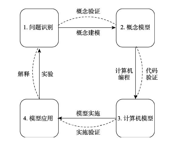