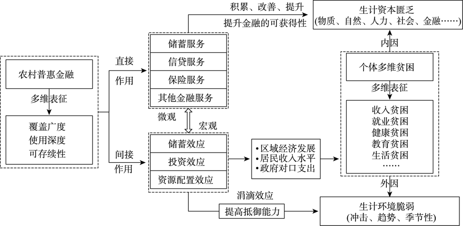
Poverty reduction is one of the primary goals of the 2030 Sustainable Development Agenda of the United Nations. Clarifying how inclusive finance alleviates rural poverty and impacts rural development can provide new perspectives and avenues for alleviating rural poverty. Based on the sustainable livelihood analysis framework, this study explored the poverty reduction mechanism of rural inclusive finance and integrated multi-source data and methods to conduct a systematic empirical test on the poverty reduction effect, pathways, and heterogeneity of rural inclusive finance. The results indicate that rural inclusive finance plays a direct and an indirect role in reducing poverty. According to the three-dimensional poverty standard, the marginal impact of rural inclusive finance is 67.5%, and the poverty reduction effect is stable. Rural inclusive finance has a variable poverty reduction effect based on group differences, such as poverty degree, educational level, and type of poverty. There is a relatively small effect of poverty reduction on the deeply impoverished groups and the poor with low education levels, but a mitigation effect on income, employment, health, and living standards poverty. For the purpose of deepening, extending, and sustaining the reduction of rural poverty through inclusive finance, it would be necessary to scientifically identify the coupling process between rural inclusive finance and poor groups/regions and to determine and develop the differentiated supply of inclusive finance and an in-depth connection with rural education.
Support measures are not only a key means to build a long-term mechanism for stable poverty eradication, but also an objective requirement to promote the effective connection between poverty eradication and rural revitalization. This study established an analytical framework for the impact of support measures on farmers' choice of livelihood strategies. Based on the household survey data, we examined the key factors that influence the choice of livelihood strategies of the rural households. The results show that: 1) Of the rural households in the Longnan mountainous area, 59.84% have enjoyed multiple support measures, among which the most common are industrial development + ecological compensation, while the most popular individual support measure is poverty alleviation by ecological compensation. 2) The livelihood strategy of the rural out-of-poverty households in the Longnan mountainous area is mainly off-farm employment, which is characterized by characteristic agricultural, non-agricultural, and diversification types. 3) The path dependence of the livelihood strategy choice of the out-of-poverty farmers is at a medium level. Farming households living in gully and valley areas, elderly farmers, and farmers with low livelihood capital endowments have a strong dependence on the path of livelihood strategy choice, and support measures have a moderating effect on them. 4) Social capital, human capital, financial capital, and location conditions have a significant impact on farmers' choice of livelihood strategies. Industrial development and e-commerce poverty alleviation interventions have a positive impact on farmers' choice of characteristic agriculture-oriented livelihood strategy, while ecological compensation and employment measures have a positive impact on farmers' choice of non-agricultural livelihood strategy. Finally, we recommended measures to optimize the livelihood strategies of farmers.
Regional compactness refers to the urban form of synergistic integration through effective interactions. In essence, it is the reallocation process of factors of production, affected comprehensively by many factors, such as spatial-temporal distance, economic scale, market competition, and policy cooperation. The Yangtze River Delta, one of the regions with the highest level of urbanization in China, has produced many practical problems that affected the coordinated development of the region towards the goal of integration and high quality development. Regional compactness is an expansion of the compact city concept in a larger space, which is considered a better geospatial model to achieve regional integration. Therefore, analyzing the evolution characteristics of compactness of the Yangtze River Delta is helpful for identifying the real stage of the Yangtze River Delta's integrated development and the key pathways of regional compactness construction and governance. This study evaluated the relationship of cities by variables of spatial-temporal distance. In the Yangtze River Delta region, intercity traffic characterizes multi-modal transportation, forming a coupled nested network composed of high-speed railways and highways. This study evaluated city compactness by the shortest travel time and travel path provided by the coupled network and constructed a compact network map. Furthermore, from the macro to the micro scales, it analyzed the spatial distribution and evolution of compactness characteristics from four aspects: The global spatial distribution, structure, the local node organization and location. The study found that the urban compactness of the Yangtze River Delta has obvious global differentiation characteristics. As time goes on, its uneven compactness distribution gradually became obvious, and its spatial agglomeration tends to be significant. At the local scale, city compactness is in the transitional period from agglomeration to equilibrium, and it tends to have the local high-clustering features at low cost in a stable state. With regard to the cities themselves, the role categories emerging from the local structure show a diversified selection mechanism.
The analysis of the characteristics of transport condition and its spatial matching with economic and social development in the Yellow River Basin is of great importance for optimizing the allocation of transport resources and improving the adaptability of transport supply. Using comprehensive transportation and socioeconomic data of the Yellow River Basin, this study analyzed the spatial pattern of transport condition at the county level and examined the spatial matching between transportation and county development quality in the basin. The results show that: The transport condition needs to be improved, and transport condition shows some mismatch with population and GDP, respectively. Counties with high level of development of transportation are concentrated along the Jinan-Zhengzhou-Xi'an-Lanzhou corridor. The spatial equity of transport supply is higher than that of economic and social development in the basin. At the zonal level, transport condition demonstrates a declining trend from the east-west Longhai-Lanxin zone to the big bent extending to the east and west, and then to the north-south zone. Fixed assets investment, industrial structure, urbanization, and economic foundation are the main factors that affect the transport condition at the county level in the basin. Furthermore, transport condition at the big bent extending to the east and west and the north-south zones are also restricted by natural factors such as elevation and slope. Of all the counties in the basin, 40.05% are in the basic matching state between transport supply and socioeconomic development. Meanwhile, 38.78% of all the counties belong to the transport disadvantage type, which are concentrated on the Qinghai-Tibet Plateau, the gully region of the Loess Plateau, and central and western Inner Mongolia Autonomous Region. Therefore, it is urgent to improve the support and guarantee capacity of transport facilities for the economic and social development of these counties.
The ecological environment in arid oasis agricultural areas is fragile. The study on the eco-environmental effect of land use transformation can provide a reference for the optimization of territorial space and the sustainable development of agriculture and rural areas in these regions. Taking Ganzhou District of Zhangye City as an example, the eco-environmental effect and spatial differentiation mechanism of land use transformation in arid oasis agricultural areas were studied by using transfer matrix, eco-environmental quality index, moving window method, ecological contribution rate, and geographical detector model. The results show that: 1) From 1990 to 2020, the production and living spaces continued to expand, the ecological space decreased in general, the land use structure changed from monotonic increase of agricultural space to diversified transformation types, and the functions changed from "ecological transformation to production" to "two-way transformations between production and living, ecological, and production". 2) From 1990 to 2020, the eco-environmental effect of land use transformation was generally positive, and the quality index of villages and towns with large cultivated land area was relatively high. The transformation from other ecological space to forest, grassland, and water areas and agricultural production space has the largest positive ecological effect, and the transformation from forest, grassland and water ecological spaces to other ecological and agricultural production spaces has the largest negative ecological effect. In recent 10 years, the negative ecological effect caused by the excessive expansion of agricultural production space into the forest, grassland, and water ecological spaces is emerging. 3) Population density, per capita GDP, and vegetation coverage are the key factors for the differentiation of eco-environmental quality, while precipitation, land development intensity, proportion of cultivated land area, and per capita water resources are the core factors. The interaction of the factors leading to the trade-off game between the increase of agricultural production space and the compression of forest, grassland, and water ecological spaces produces an adaptive steady-state mechanism, thus forming an overall low eco-environmental quality pattern. The different self-organization, adaptation, and transformation abilities of villages and towns in the face of external interferences lead to different economic development and land use modes, and then shape the differentiated eco-environmental quality pattern of villages and towns.
The dual effects of global warming and urban heat island have increasingly exacerbated the extreme heat risk, and given severe challenges to the health of urban residents and socioeconomic development. Accurately assessing the population exposure to urban extreme heat environment has become a current research hotspot. In this study, we used the new ECOsystem Spaceborne Thermal Radiometer Experiment on Space Station (ECOSTRESS) and mobile phone signaling data to explore the spatiotemporal variation of land surface temperature and population in Xi'an City, developed a population exposure risk assessment model, and revealed the spatiotemporal pattern and dynamic characteristics of the exposure risk on a refined scale. The results show that: 1) The diurnal cycling of land surface temperature in summer showed obvious fluctuation characteristics, especially a large difference between day and night. The average temperature in the daytime was 35.5 ℃ and 21.5 ℃ at night, and land surface temperature exhibited more spatial variations in the daytime. The urban heat island effect of different intensities existed at all times of the day, and it varied from aggregation state to discrete state and then to aggregation state. 2) Nearly three quarters (73.6%) of the population were distributed within the third ring road with a single center structure, and the population was concentrated along the central axis. The population distribution change displayed the characteristics of "centripetal in the daytime and centrifugal at night". 3) The medium risk, high risk, and extremely high risk areas of population exposure were mainly scattered in the central area of the city, and 86.6% of the extremely high risk areas were located within the third ring road, while the negligible risk and low risk areas were mainly concentrated in the periphery. 4) The dominant factors leading to difference of heat exposure risk were grouped into three types including temperature-dominated, population-dominated, and co-dominated, and their proportion to the total urban area were 37.9%, 30.6%, and 31.5%, respectively. This research can provide a scientific reference for the heat exposure risk identification and targeted adaptive strategies.
Settlement intention affects the settlement decision of the floating population in cities, and the increasing housing burden has gradually become a key factor restricting the settlement decision of floating population. In view of the relative deficiency of existing research on how housing burden affects the settlement intention of floating population and differences between groups, this study took Shanghai Municipality as an example and used the data in 2012 and 2017 collected from the migrant population dynamic monitoring survey (CMDS) in Shanghai and a binary Logistic regression model to analyze the influencing factors and changes of the floating population's settlement intention, and examined the influence of housing burden on settlement intention and decision of the floating population. The results show that: 1) The increase of housing price to income ratio has a significant negative effect on the floating population's settlement intention, and the groups with lower education level and lower employment status suffer a more significant effect. 2) The rapid growth of housing price increases the housing burden of the floating population, increases their settlement difficulty, and forces them to change their settlement intention and decision. 3) Housing burden will lead to the "driving out" effect on the floating population with lower skills, while the increasing pressure will lead to more people moving out or reduce the quality of life. It is recommended that governments should provide more inclusive, affordable, and diversified housing for the floating population to share the development achievements, so as to promote the ultimate realization of the development goals of "houses are for living in, not for speculation" and common prosperity.
Accessibility is one of the core topics in the study of human geography and related disciplines. Based on the theory of time geography and the human-oriented research paradigm, the measurement methods of spatial-temporal accessibility have attracted the attention of scholars and have become an important approach in quality of life and social equity research. This empirical study measured the individual spatial-temporal accessibility by characterizing daily potential path area and using activity-travel diary data of residents in Shanghai suburbs in 2017. Firstly, road network analysis and secondary development were used to measure individuals' potential path area in weekdays and weekends. Secondly, flexible time, daily potential path area, and density of accessible facilities were taken as indicators to analyze the characteristics of individual spatial-temporal accessibility, and three-dimensional GIS visualization and variance analysis were used to compare the differences in both spatial and temporal dimensions. Finally, the effects of location factors, time factors, and socioeconomic attributes on residents' spatial-temporal accessibility were explored by using multiple regression analysis methods. The results show that significant differences exist in residents' spatial-temporal accessibility, and residents living in outer suburbs face stronger spatial-temporal constraints and greater spatial dilemmas; the location and time factors are the main influencing factors of residents' spatial-temporal accessibility; spatial-temporal accessibility with individuals as the unit of analysis can better reveal the differences between individuals and groups. We also found that spatial-temporal accessibility has advantages in revealing the dynamic characteristics of accessibility in the context of geographic mobility, and the differentiation in temporal and spatial dimensions reflects the need to pay attention to different locations and different groups of people in suburban development and construction. This study is an empirical test of individual spatial-temporal accessibility measures in the suburbs, which is helpful for understanding the relationship between individual daily activity arrangements and spatial-temporal accessibility. The results of the study provide a basis for the optimal spatiotemporal configuration of facilities and the improvement of residents' quality of life in the construction of suburban new towns.
As the aspiration for a better life grows, people living in allotment housing, as a category of "sandwich class", deserve to have their living environment and subjective sense of well-being fully appreciated. Mixed residential communities in Shenzhen are used as an example to reveal the mechanism by which the environment of allotment housing settlements affects residents' subjective well-being. Questionnaire surveys and interviews were conducted for three typical settlements, and structural equation models were constructed by using sense of place and housing type as mediation and moderating variables respectively for the influence of settlement environment on residents' subjective well-being. The following findings were obtained. Overall, the residential environment has a significant direct impact on residents' subjective well-being. The social environment has a direct impact on subjective well-being. However, with regard to the built environment, residential zone environment, community environment and housing environment do not have a significant effect on subjective well-being. Analysis of mediation effect shows that social environment can indirectly affect subjective well-being by building residents' sense of place. Finally, with regard to housing type, the subjective well-being of talent housing tenants is more strongly influenced by the social environment than that of guaranteed housing tenants. The results of the study can provide scientific decision support for the improvement of the housing allocation system.
With the rise of the third wave of craft revival in the West, "making culture" has become an emerging topic concerned by Western geographers, and the embodiment and material production forms of traditional craft making have also received attention. This research selected Shitouzhai Bouyei batik, a traditional craft intangible cultural heritage in Guizhou Province as a case study. Based on the perspective of geographies of making, we analyzed the production practice of Bouyei batik. The research found that batik production is an embodied, material, local, and relational practice. In different spaces such as human body, family, workshop, community, and online, the body of the craftsman is the subject of the batik production practice and through embodied practice, the batik skills can be improved, and the products can be innovated by using their agency. The making practice also shapes the body of the craftsman, resulting in positive or negative embodied experience. The batik production process has distinct material characteristics, and the agency of materials guide a craftsman to carry out human and material cooperative production; Local elements such as local natural environment and traditional culture are the basis and conditions of batik production, and the production practice of batik also shapes the identity and characteristics of the place; Batik production is not only a creative practice for craftsmen to express themselves, but also to construct a specific sociocultural relations. The research helps to strengthen the attention to the cultural dimension in the practice of economic production, and provides important empirical evidence for the theoretical study of cultural economy. By paying attention to the physical skills and embodied experience of the craftsmen, it also helps to provide more caring safeguards in the practice of intangible cultural heritage protection.
Understanding criminal behavior from the perspective of journey to crime (JTC) is of great significance for that it can help better reveal the mechanism of crime occurrence and crime prediction. However, limited by the access to criminal data, seldom research in China has focused on journey to crime so far. Existing studies mainly discussed the impact of the characteristics of the target community on offender's journey to crime, and few studies comprehensively considered the integrated impact of the residential community, the target community, and physical barriers during the journey to crime. To fill theses gaps, this study applied a multilevel linear regression model based on data of 4119 thief trips in ZG City, one of the bustling metropolises in China, to explore the influencing factors of journey-to-crime distances at the levels of individual layer and target community layer. The results show that: 1) Compared with the target community layer, the individual layer (including factors of personal socioeconomic attributes, crime location selection preference, physical barriers of travel, as well as differences between residential and target communities) has a greater impact on the journey-to-crime distance. The older the offender is, the shorter the distance of their journey to crime will be, while the effect of gender of offenders is not significant. 2) The physical barriers during the journey to crime have a strong explanatory power for the model. The more barriers the offenders have to travel pass, the longer distance of their journey to crime will be. Besides, the barriers will affect the effects of subways, supermarkets, and banks in the target community on the journey-to-crime distance. 3) The difference in facilities between the residential community and the target community has an impact on the journey-to-crime distance. More bus stops, schools, and supermarkets and fewer subway stations in the residential community than those in the target communities will lead to shorter distance of journey to crime. These findings shed some light on the criminal geographic profiling and crime prevention and control.
Due to their geographical location and outstanding resource endowments, the South Caucasus countries have always been an area where multiple civilizations meet and great powers play games. It is of great significance to explore the evolution of China's geo-relationship with them for the future cooperation in economic development and political strategies. Based on the power theory of international relations, this study constructed a geo-potential model to describe the evolution characteristics of the geo-relationship between China and the South Caucasus countries from 2000 to 2020. The results indicate that: 1) The geo-potential between China and the South Caucasus countries from 2000 to 2020 showed an upward trend year by year and experienced three development stages. In the period from 2000 to 2005 the geo-potential was low and stable, the period from 2006 to 2012 was the initial growth stage, and the period from 2013 to 2020 was a period of rapid growth. 2) In terms of the average geo-potential in 20 years, growth rate, and growth range, the spatial trend is China-Armenia > China-Azerbaijan > China-Georgia. As of 2020, the geo-potential of China-Armenia was the highest; In terms of the temporal changes of geo-potential, China-Armenia started at a low level and rose rapidly in the later period; China-Azerbaijan started at a high level and fluctuated in the later period; China-Georgia started at a low level and rose evenly in the later period. 3) The driving mechanisms that affected the evolution of these geo-relationships can be divided into positive mechanism and negative mechanism. The positive driving forces include geo-location, geo-economy, geo-culture, and geo-diplomacy. Geo-location is the background force, geo-economy is the dominant force, geo-culture is the potential force, and geo-diplomacy is the root force. The negative driving forces include, on the one hand, the unstable internal geo-politics and the strong divide of the internal geo-culture in the region, and on the other hand, the difficulty of intervention of China's geo-diplomacy and the weakness of competition of China's geo-economy. The internal elements of the two driving systems interact with each other and jointly affect the evolution of the geo-relationship between China and the South Caucasus region.
As China's urbanization development enters the middle and late stages, the suburbs have become one of the essential residential places. Therefore, it is necessary to systematically examine the context and research prospect of suburbanization in China under the new-type urbanization. In this study, the CiteSpace 5.8 software was used to analyze the co-occurrence network of keywords and detect emergent words in the core journals and CSSCI and the literature on suburbanization in master's theses and doctoral dissertations of CNKI, and to explore the overall characteristics of suburbanization research. This article systematically reviewed the hotspots and frontiers of suburbanization research and its evolution from 1983 to the present. The results show that the study of suburbanization in China was in the initial stage before 1996. With the rapid development of urbanization, the suburbanization studies in China entered the active stage from 1996 to 2015. However, the related studies have been gradually weakened since 2015. The research hotspots of suburbanization in China mainly include suburbanization and urbanization, population distribution and mobility of suburbanization, dynamic mechanism of suburbanization, and the specific study of case areas. It conforms to the process of "learning from others - understanding the phenomenon - exploring the essence - practical application". In the future, it is necessary to re-examine the connotation of suburbanization and the relationship between suburbanization and urban space reconstruction. More attention should be paid to the suburbanization of different demographic groups. Research on the suburbanization processes in the inland areas, including the central, western, and northeastern areas, are also essential. In addition, the analysis of the sustainable development of suburbanization and soft safeguarding measures needs to be highlighted.
Conservation tillage plays an important role in preventing soil erosion, improving soil quality, and ensuring food security. As farmers are the direct decision makers of conservation tillage technology adoption, studying their adoption behavior and influencing factors can help promote the application of conservation tillage technology. In order to provide a reference for a more effective promotion of conservation tillage technology, this article summarized the research on farmers' conservation tillage technology adoption behavior and influencing factors in China and internationally through a systematic analysis. The results show that different types of farmers have great differences in their adoption behavior of conservation tillage technology. The research area of farmers' adoption of conservation tillage technology is relatively concentrated. The factors that influence farmers' technology adoption behavior mainly include basic factors and differential factors. Based on these analyses, further research directions and outlooks are proposed. They include taking into account the heterogeneity within the farmer group, focusing on the integration of research theories, and strengthening interdisciplinary comprehensive and systematic research.
Effectiveness assessment of protected areas is an important means to measure management and protection effects and put forward suggestions for improvement. From the perspective of coupled human-environment system, this study divided the effectiveness assessment of protected areas into four stages: infrastructure construction, primary protection, ecological function enhancement, and human-environment harmony, corresponding to the four targets of a well-established protection system, the safety of protected objects, ecosystem health, and human well-being, respectively. On this basis, we analyzed the role of effective management theory, landscape sustainability theory, and social-ecological network theory in guiding the assessment of the effectiveness of protected areas. By examining the progress of the effectiveness assessment of protected areas in China, this article proposed four future research directions, including increasing the importance of community governance in the assessment system, shifting from focusing on biodiversity conservation to considering the improvement of human well-being, exploring the mechanism of management work on the effectiveness of protected areas, and promoting the construction of monitoring networks and data platforms for protected areas, in order to improve the timeliness, comprehensiveness, and soundness of the effectiveness assessment of protected areas, and to promote the harmonious coexistence of humans and nature.