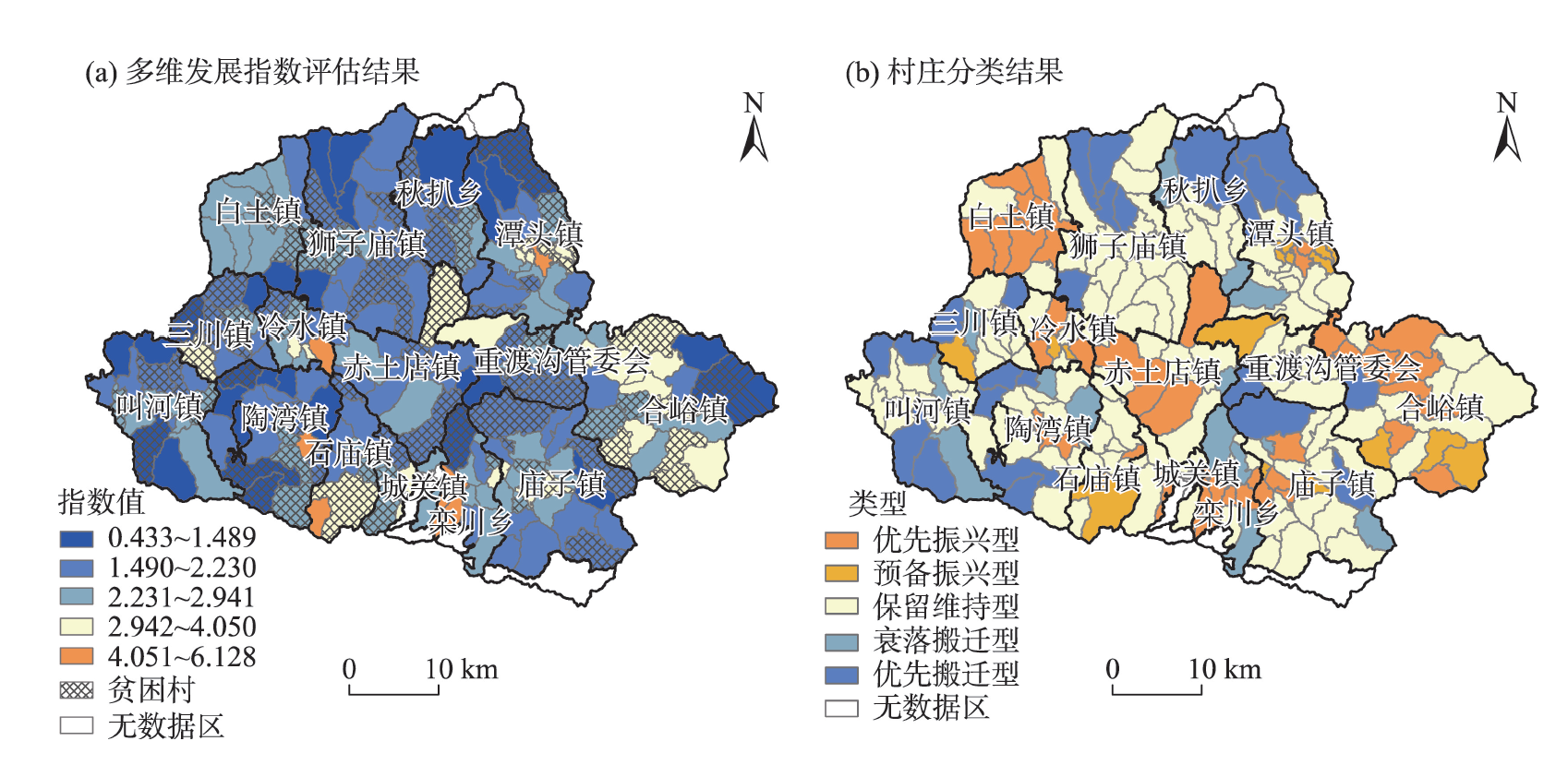
Accurate assessment and classification of rural development levels is an important issue in rural revitalization research, which can provide a scientific basis for the implementation of rural revitalization strategies by development type and stage. Taking Luanchuan County, Henan Province as an example, this study integrated multi-source data such as administrative village census and electronic maps to construct a multi-dimensional development potential measurement indicator system for the village scale, and carry out multi-dimensional evaluation and type identification of rural development potential. The results show that: 1) The overall situation of rural multi-dimensional development potential in Luanchuan County is poor, with only 45.89% of the villages having medium and above development potential, and the interaction between any two dimensions has a nonlinear enhancement effect on explaining the spatial differentiation of multi-dimensional development potential. 2) The spatial differentiation characteristics of rural multi-dimensional development levels are obvious. Villages with high development potential are concentrated near the county seat and where key township centers are located, while villages with low and medium-low development potential are mainly distributed in the border areas of the county and in the areas between the towns in the central part. 3) The development level of each dimension shows relatively significant spatial agglomeration characteristics, but the spatial agglomeration pattern is different for different dimensions. Villages with higher development level in geographical location and natural background are mainly concentrated in areas with good resource endowment and relatively flat terrain; and villages with higher development level in the four dimensions of geographical location, population development, economic foundation, and social welfare gather near the county seat, township centers, and tourist attractions. 4) According to the multi-dimensional development assessment results, the villages are divided into five types: priority revitalization, preliminary revitalization, maintaining the status quo, decline and relocation, and priority relocation. Based on the characteristics of different types of villages, revitalization paths and development strategies are proposed to improve the development quality of villages.
Rural production space system is the spatial assembly for the implementation of rural industrial revitalization, the relationship and strength of the various factors of the system are directly related to the operation of the system, and a stable and orderly system is the basic guarantee for the realization of industrial revitalization. Based on the relationships between the factors of rural production space system, and on the basis of identifying common indicators through literature review and characteristic indicators through policy text analysis, this study built an indicator system, analyzed the spatial representation of factors of the system, and used structural equation model to analyze the role of the relationship and strength of the factors. Taking Chongqing Municipality as the research object, we tested these relationships and put forward its industrial revitalization path according to the local conditions. The results show that the method of constructing the indicator system from the two dimensions of commonality and individuality is scientific, reasonable, and practical; The relationship and strength of the rural production space system factors in Chongqing are different, and the spatial representation of the rural production space system factors presents a zonal pattern; This study put forward the path to promote the industrial revitalization of Chongqing from three aspects: consolidating the industrial infrastructure, constructing the talent cultivation system for industrial revitalization, and enhancing the efficiency of industrial upgrading.
The type of homestead reuse is affected by factors mainly including village and homestead utilization characteristics. Taking Jinghai District of Tianjin Municipality as an example, this study constructed a theoretical analysis framework for the selection of homestead reuse types by coupling "village-land use". By constructing the measurement models of village characteristics and homestead utilization characteristics, this study classified and determined the types of village homestead reuse from these two aspects for the 56 pilot villages of homestead reform in the district, to provide policy recommendations for rural spatial governance. The results show that: 1) The characteristics of villages are identified as three types: industry-oriented, resource-oriented, and balanced development. 2) The utilization characteristics of homesteads are identified as single-function dominant and multi-function dominant based on the village as a unit. 3) Based on the characteristics of village and land use, the relationship function is constructed to identify the types of homestead reuse in three categories: multi-subject category, factor flow category, and characteristic resource category. The research suggests that using multi-source data to identify the types of homestead reuse based on the characteristics of village and land use is an effective way to provide guidance for homestead reuse and the reform of the homestead system.
Resilience theory is one of the core topics of sustainability science. Integrating rural regional system and resilience theory at the micro-scale is a response and reflection to the rural revitalization strategy. By constructing a rural regional system risk-resilience (R-PAT) model in mountainous areas, this study examined the system resilience of 68 sample villages in Luotian County of the Dabie Mountains using entropy method, and analyzed its spatial patterns. After identifying the R-PAT type, the influencing factors of the spatial differentiation of the rural regional system resilience in mountainous areas were examined through geographical detector. The results show that: 1) There are significant differences in the resistance, adaptability, transformability, and comprehensive resilience index of villages in Luotian County. The comprehensive resilience index of the sample villages is not high in general and has great potential for improvement. 2) According to the changes of resilience index and risk index, the rural regional systems in mountainous areas are divided into four types: high risk-low resilience, high risk-high resilience, low risk-high resilience and low risk-low resilience. The high risk-low resilience type and low risk-low resilience type are dominant in Luotian County. 3) The resilience of rural regional system in Luotian County is affected by multiple factors. Rural endogenous power is the key factor for the spatial differentiation of resilience level of the area, rural natural and social backgrounds are the basic factors, and rural development potential is the driving force for the continuous improvement of the system potential and the gradual strengthening of the resilience capacity. This study focused on applying the resilience theory to the micro spatial units of mountainous rural areas to provide theoretical guidance and case support for the consolidation of poverty alleviation achievements in these areas and their revitalization.
Under the background of "mass entrepreneurship and innovation", the underlying mechanism of migrant opportunity entrepreneurship is of great significance for promoting the new-type urbanization and high-quality development. By focusing on individual capital endowment and urban contextual factors, this study analyzed the mechanisms of opportunity entrepreneurship of migrants in urban China by using data from the 2017 China Migrants Dynamic Survey and dual-level logistic modeling, and comparing three different types of migration scopes—interprovincial, interprefecture/intercity, and intercounty. The results show that: 1) The overall level of opportunity entrepreneurship of migrants was low, whereas the entrepreneurial rate of interprovincial migrants was higher than interprefecture/intercity and intercounty migrants. 2) Different capital endowments had different effects on the opportunity entrepreneurship of the three types of migrants. A complementary relationship between social capital and financial capital was observed. With the expansion of the migration scope, the influence of social capital on migrant opportunity entrepreneurship was increasing, while the impact of financial capital was gradually weakening. 3) Urban context explains 10%-20% of the variation of the opportunity entrepreneurial decision of migrants. The larger the scope of migration, the more sensitive the migrants were to the change of external context. In particular, the segmentation of labor market significantly affected the entrepreneurial decision of the interprovincial migrants. In addition, the interaction between individual capital endowment and urban context had both negative and positive effects on opportunity entrepreneurship. This study revealed the influencing factors of opportunity entrepreneurship and its difference among migrants in different migration scopes, which provides a reference for improving urban entrepreneurship support system.
The floating population's housing choices in the destination cities is directly related to their citizenization level and the high quality development in the new phase of urbanization. While a large body of literature has been generated concerning floating population's housing choices and its determinants, little has been done regarding that the role of floating population's spatial capital of the original places. Therefore, based on the 2017 China Migrants Dynamic Survey conducted by the National Health and Family Planning Commission and China's city statistical yearbook 2017, this study analyzed the ways in which spatial capital in the original places of floating population shaped their housing choices in the destination cities. The results show that the housing choice of the floating population in the destination cities is mainly rent housing, supplemented by property right housing and free housing. Findings from our analysis indicated that the floating population's spatial capital in the places of origin had significant effect on their housing choice of in the destination cities. Specifically, there is not a simple linear correlation between the city size of the original places and housing choices in the destination cities; the location and the level of humanistic development in the places of origin have significant effects on housing property rights in the destination cities. However, being from town and county places of origin, floating population tends to obtain housing through the market. The robustness test is carried out by deleting a small number of samples from each prefecture level city, which shows that the above conclusions are robust and reliable. Our findings also indicated that the floating population's spatial capital in the places of origin exerted different impacts on different heterogeneity groups in terms of their generation, education level and income. More precisely, compared with the new generation, high education level and high-income floating population groups, the heterogeneity analysis results show that the influence of spatial capital in the places of origin on the housing choices of the floating population in the destination cities is significantly different between different generations, education level and income level. Based on a new way of conceptualizing and measuring spatial capital in the place of origin, we especially focused on the role of spatial capital in the places of origin of floating population, which expanded the perspective of research on housing choice differentiation of floating population. In the meantime, the results also have important policy implications for further optimizing the housing policy for floating population and promoting the citizenization of floating population.
Coastal regions are extremely vulnerable to compound floods caused by extreme rainfall and strong storm surge. To improve the effectiveness of flood control measures in Chinese coastal cities and reduce the losses caused by urban compound flooding, it is important to analyze the joint probability of occurrence of extreme rainfall and strong storm surge and design the joint distribution function of daily storm surge and cumulative rainfall. In this study, we employed the Copula function to fit the joint probability distribution of storm surge and cumulative rainfall from 1979 to 2014. Then we used the Kolmogorov-Smirnov (K-S), Akaike Information Criteria (AIC), and Bayesian Information Criteria (BIC) statistical methods to obtain the optimal Copula function between storm surge and cumulative rainfall at each gauge alone the coast of China. Finally, based on the Copula method, we assessed the design value of compound scenarios of storm surge and rainfall in coastal China. The results indicate that the northern and southern parts of Chinese eastern coast have high frequency and the middle part has low frequency of compound disasters of strong storm surge and extreme rainfall. Western Guangdong, northern Fujian, southern Zhejiang, Shandong, and Liaoning provinces have a high frequency of compound disasters. Under the 50-year return period, the Beibu Gulf, northern Hainan Island, the coast of Zhejiang Province, and parts of the Bohai Bay have extreme rainfall and high storm surge. This study shows the temporal and spatial distribution of compound disasters of storm surge and rainfall in coastal China, and provides a framework for compound disaster scenario prediction.
Urban waterlogging is one of the most common natural disasters. In-depth analysis of its influencing factors and estimation of high-risk waterlogging areas are of great significance for waterlogging prevention and management. Although some studies have approached these issues through advanced machine learning methods such as random forest and neural network, the identified influencing factors are mainly related to the two-dimensional space. Moreover, while traditional methods require both accurate positive and negative samples, there is an inevitable subjectivity in the selection of negative samples. To address these disadvantages, this research took Shenzhen City as the study area and employed the MAXENT model, which does not require negative samples, to explore the relationship between potential influencing factors (including three-dimensional building factors) and waterlogging risk during 2015-2019. The results show that the dominant environmental factors behind the density of waterlogging hotspots were the proportion of impervious surface, the proportion of green space, population density, rainstorm peak rainfall, and fluctuation of the terrain. With regard to the three-dimensional building factors, building congestion, average building height, and building shape coefficient have a crucial impact on urban waterlogging. According to the waterlogging probability estimated by MAXENT, the total area of potential high-risk waterlogging areas in Shenzhen is approximately 491 km², accounting for 24.58% of the total area of the city. These areas are mainly located in Longhua District, Nanshan District, the north of Longgang District, Guangming District, and Futian District. Through the spatial autocorrelation analysis of the potential high-risk areas, we found that some areas in the north of Nanshan District, the west of Futian District, and central Luohu District where there were no waterlogging hotspots in the past, exhibit high concentration levels. This indicates that the waterlogging probability in these areas would be positively affected by the surrounding areas. Therefore, focus should be placed on high-risk areas for achieving more accurate waterlogging prevention and management. Urban waterlogging risk assessment is an important part of disaster management. The assessment results of waterlogging risk not only can provide support for disaster prevention and risk mitigation, but also are essential for protecting people's lives and the sustainable development of cities.
The scientific evaluation of a country's position in the global system is the basis for formulating foreign policies. At present, China's status as a developing country has been questioned by Western countries. Chinese scholars have demonstrated China's status as a developing country by country comparison, but lacked a response from the perspective of global scale classification. Based on the polyhedron and the Lorentz curve classification methods, this study constructed an indicator system and measurement model for the classification of development level of economies from multiple dimensions including economy, society, environment, and governance, and further divided 190 economies around the world into developed country types I-III, developing country types I-V, and transitional economies, at nine types. Moreover, it discussed the development characteristics of different types of economies and China's status in the global country classification system. The results show that: 1) There are significant differences in the development levels of different types of economies in the dimensions of economy, society, environment, and governance. 2) The development level of developed economies is generally high in all dimensions, showing the characteristics of "keeping abreast" in general; the development indicators of transitional economies in many dimensions are close to that of developed economy type III, and most economies are in a development stage that is gradually transitioning to developed economies; Significant structural differences exist in developing economies in the level of sub-development dimensions. 3) China belongs to the developing country type I, ranked 64th among the 190 economies and 13th among the 139 developing countries. 4) China has the general characteristics of developing countries in terms of the ranking of the multi-dimensional development level among the global economies and the differences in the development level of various dimensions. The application of the Lorenz curve in this study can enrich the theory of regional development classification, and the conclusions can provide a reference for countering Western countries' doubts about China's status as a developing country.
Land-sea coordination is an important strategy for constructing a powerful marine country. It is of great significance to evaluate the coordinated development level of the coastal zone—the core area of land-sea coordination—to promote the sustainable development of such areas. Taking the coastal zone complex system of Wenzhou City as the research area and using data during 2010-2018, this study selected relevant evaluation indicators of the land and marine subsystems to build a comprehensive evaluation model of coastal zone complex system development level, and used the coupling coordination degree model, information entropy, and degree of sequence to evaluate the composite system coordinated development in the study area and explored the mechanism of influence of coastal zone exploitation on its coordinated development level. The results show that: 1) The overall development level of the land and marine subsystems showed an upward trend. The high value areas of the comprehensive development index of the land subsystem were concentrated in the main urban area of Wenzhou, while the low value areas were concentrated in the central and southern parts of the city, and the development gap between the districts and counties increased. The internal coordination of the land and marine subsystems has gradually increased and reached a good coordination state. The coupling degree of the coastal zone composite system is close to or up to 1, which indicates a benign resonance coupling state, and the coupling coordination degree also keeps improving and reaches a good coordination state. 2) In the study period, the information entropy of the coastal zone complex system gradually decreased, and the degree of sequence kept rising, with a positive trend of coordinated development. 3) The mechanism of influence of coastal zone development on the coordinated development level of coastal zone complex system is mainly manifested in four aspects: improving the transportation and utilization capacity of land and marine energy resources, changing land and marine ecological environment, promoting land and sea industrial agglomeration and strengthening subsystem association, and promoting land and sea social and cultural development.
In light of Bourdieusian theory of practice and the concepts of field, doxa, habitus, and capital and using interview data of 33 returnee students and 73 employers, this study analyzed the job-hunting dilemma of overseas returnee students from the perspective of human geography. The analysis shows that the returnees and employers are situated in the field of international education and the field of local employment respectively. The international education field is mainly characterized by the rankings of global universities released by Western institutions, and is rooted in the Western-led global higher education hierarchy. Therefore, returnee students often believe that the capital acquired by studying abroad is convertible in the local field of professional employment, which is conducive to the upward social mobility of students and families. Employers' recruitment practices are regulated by the localized employment field. Hence, the demand for and recognition of overseas capital has gradually decreased, and more emphasis has been placed on local cultural capital and embodied experience rooted in the local field in recent years. Taking local realities, global educational structures, and individual agency into account together, this study provided a theoretical explanation for the asymmetric perceptions and related practices regarding overseas capital value between returnees and employers, revealed the process of cross-border transfer of capital in the context of socio-geographical mobility and globalization, and underlined the place embeddedness of capital, common knowledge, and habitus in the context of immigration research.
As one of the key research aspects of rural transformation and development in China, human settlement in traditional villages comprehensively demonstrates the choice of settlement locations, spatial functionalities, and reconstruction of social-cultural connections. It also actively demonstrates the innovation of traditional agricultural societies. This study defined the concept of traditional villages, explored the conceptual definition of human settlements in traditional villages, analyzed their connotation and system composition, clarified their characteristics and manifestations, and offered an example of the systematic approach to the traditional village human settlement transformation and development. The results show that: 1) The research on the transformation and development of traditional village human settlements can be approached from the following aspects: connotative of the transformation, system composition and performance of the transformation, division and spatial differentiation of the transformation stages, and path and mode of the transformation and development. 2) Human settlements of traditional villages include three dimensions (subject, space, and function dimensions) and five subsystems (natural ecological, social-cultural, industrial economic, regional spatial, and multiple subject subsystems). The transformations of the subsystems are interdependent and have their own focus, and need to be categorized and implemented differently. 3) Natural ecological and regional spatial subsystems are the conventional focus of research on human settlement transformation in traditional villages, which belongs to the research of original material space. The study of social cultural, multiple subject, and industrial economic subsystems is the innovative research focus and belongs to the constructive material space. Based on the problems, goals, and demand orientation, comprehensive study of transformation development from the system perspective is the new trend of future human settlement research.
Border areas are important national security buffer zones and vulnerable areas under the influence of multiple power spaces. Scientifically summarizing the development process of border research will help clarify the context of border research and provide scientific support for realizing a stable border with security and sustainable development. This study was based on data of academic publications on border research in the fields of human geography in China from the China National Knowledge Infrastructure (CNKI) and Web of Science (WoS). With the help of the scientific knowledge map method, the basic characteristics of China's border research process, trends, and hotspots since 1990 were analyzed. The study found that China's border research has experienced an "open exploration-social construction-strategic guidance" development process. The research hotspots have gradually shifted from the northeast to the southwest, and "border trade", "border tourism", "border port", and "Belt and Road" are the four main keyword clusters. The main contents of border research include border trade and development and opening-up, border tourism resource development, social construction and harmonious development, border ports and urban functions, as well as geographical environment and border security. At present, China's border research is still insufficient in terms of exploring the patterns and quantitative analysis. On the basis of constructing a framework of border geographic research integrating multi-subjects, multi-elements, and multi-scales, we propose to strengthen the research on border risk and security, cross-border cooperation mechanism, "border effect" theory, and sustainable border development, which may provide a support for China's border security and modern governance.
With the rapid development of motor traffic, urban traffic safety problems are becoming increasingly serious. As a key factor influencing the characteristics of regional traffic flow and travel behavior, the characteristics of urban road network have an important impact on the frequency, type, and spatial distribution of regional traffic accidents. Based on the theoretical analysis of the relationship between urban built environment and traffic accidents, this article summarized the mechanism of impact of urban road network characteristics on traffic accidents from two aspects: road network patterns and geometric-topological characteristics. The potential mechanism of impact of urban road network characteristics on traffic accidents was analyzed by exploring the relationship between urban road network and travel behavior. Existing studies indicate that there are differences in spatial scale effects on the type, frequency, and severity of traffic accidents caused by road network patterns such as grid-iron, warped parallel, and loops-lollipops, as well as road network topology indicators such as centrality and connectivity. Furthermore, reasonable geometric characteristics of road network such as intersection density, road network density, and block density play an important role in improving traffic safety. Future research needs to further characterize the structure, function, and other characteristics of road network using complex network theory, and to provide in-depth analyses on the driving mechanism and non-linear effects of complex road network characteristics on traffic accidents from the perspective of travel behavior by controlling the effect of residential self-selection. Future research also needs to consider the potential interaction between road network characteristics and the built environment on traffic accidents.
At present, the academic community has not yet to reach a consensus on the definition of the ecological shelters (ES) concept. Due to the lack of theoretical guidance, the scientific application and mechanisms of ES construction is lacking. Therefore, this study systematically clarified the meaning, identification system, and construction practice of ES, summarized the history and challenges of ES construction, and postulated countermeasures and suggestions for improvement. We demonstrated that ES has the dual connotation of region and function, which is manifested as specific spatial location, ecosystem structure, ecological process, and protection object. It is a compound system of ecology, economy, and society and possesses the basic characteristics of attributes related to public goods. In the construction of ES, it is necessary to scientifically identify the ES and its scope according to its geographical location, dominant function, ecological stress, and varying scales. Moreover, the natural attributes and ecosystem function should be respected and cross-regional cooperation should be encouraged. Finally, a systematic management system for ES construction should be established to coordinate its construction with economic and social development.
Marxist geography is an important school in human geography, but also has a profound influence on other disciplines. David Harvey's Social Justice and the City is the founding work of Marxist geography. This book is highly theoretical and involves many large and complex issues, and thus is also difficult to interpret. Harvey tried to understand and analyze urban(ism) problems from a holistic perspective, and innovated the theory of "social processes-spatial form". By comparing the urban research methodology between liberalism and Marxism, he concluded that the nature of theory arises from the synthesis of methods and philosophy, the nature of space lies in human practices, the nature of justice depends on the operation of the social processes, and the nature of urbanism is the needs and products of capital production. This work created the knowledge foundation of Marxist geography, forged the critical path of urban research, and opened up the growth point of contemporary Marxism. Chinese intellectuals should pay close attention to the uneven urbanism, put forward the "general urban problem" in the new development stage, insist on and strengthen the thoughts research, and make a bold theoretical revolution around contemporary issues through symptomatic reading of different classic theories.