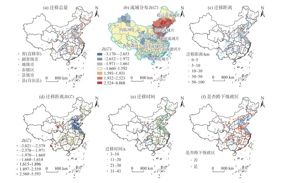
The scientific and reasonable siting of administrative centers directly affects the efficient allocation of resource elements, equality of basic public services, coordinated and balanced regional development, and modernization of national governance system and governance capacity. This study used spatial analysis and the difference-in-differences (DID) model to analyze the basic characteristics, mechanism, and economic effects of administrative center relocation in China since the reform and opening up in 1978. The results show that in terms of relocation characteristics, the higher the administrative level, the longer the relocation distance is, and the relocation is mainly concentrated after 2000, especially in North China, while the relocation distance in western China is generally much longer than that of other regions. In terms of relocation effects, the growth rates of population, economy, and construction land around the new administrative centers are obviously faster than that of the original administrative centers. On the whole, the relocation of administrative centers plays a certain role in promoting economic development, but there is also a clear spatial heterogeneity. In terms of the factors and mechanism of influence, the process is mainly influenced by the restriction of resources and environmental conditions, the promotion of old city planning and reconstruction, the guidance of the development and construction of new areas, the reform of the administrative system, and urban development strategies. The relocation of administrative centers is usually the result of the joint action of multiple factors.
The current geographic research is insufficient in examining the service function of small towns at the township scale. To make up for this limitation, this study carried out a quantitative evaluation of the service function of small towns, from the perspective of borrowed size and agglomeration shadow. We collected point of interest (POI) data from the Amap open API platform, and selected 14 industries related to service functions. Using the kernel density method, analytic hierarchy process, and multiple linear regression model, we evaluated the service function of small towns in southern Jiangsu Province near Shanghai. The results show that: 1) The kernel density of service facilities in small towns near Shanghai is generally high. High density and medium-high density areas were mainly distributed in the downtown, district (county-level city), and surrounding areas of the cities and along the expressways, national highways, and railways, and presented the spatial structure of "point-axis". Except for a few small towns with small population, the development of small towns away from the central urban areas (towns) was relatively balanced. The spatial distribution characteristics of different service industries varied, but the differences were not significant. 2) The service function index values of small towns near Shanghai were generally high. The highest index values mainly concentrated within the 100 km buffer zone and decreased in the 150 km to 200 km buffer zone. 3) Shanghai had a significant impact on the service function index values of small towns in southern Jiangsu Province, especially within the 100 km buffer zone. The service function of small towns in southern Jiangsu coexists with the process of borrowed size and agglomeration shadow from Shanghai.
Cities provide support for tourism and their resilience level has an important impact on regional tourism development. Based on the panel data of various regions of the Yangtze River Delta urban agglomeration from 2004 to 2018 and the quantitative assessment of urban resilience, the spatial spillover effect of urban resilience on tourism economy was revealed by using the spatial panel Durbin model. The results show that the spatial difference of urban resilience level is significant, but the overall resilience level is on the rise. There is a strong spatial correlation between urban resilience and tourism economy, and urban resilience has a significant spatial spillover effect on tourism economy (ρ=0.444, P<0.01). Among the resilience dimensions, urban economic resilience and urban ecological resilience have positive spillover effects on tourism economy, while urban social resilience and urban engineering resilience have negative spillover effects on tourism economy. In the future, the development of urban tourism needs to pay attention to the level of urban resilience and its spatial spillover effects, and avoid the siphon effect. It is also necessary to strengthen regional exchanges and cooperation in the Yangtze River Delta urban agglomeration to promote the high quality development of tourism economy.
Exploring the mechanism of regional economic resilience is of great significance for realizing the rapid recovery of the economy after shocks. As a major province of economic activities, Jiangsu Province's industrial structure changes are the epitome of China's economic transformation. An analysis of its resilience changes and the inherent logic can provide a reference for other provinces. This research analyzed the economic resilience level of Jiangsu Province based on a longitudinal comparison. It used network analysis methods to study the multi-year input-output table of the province to clarify the changes in industrial structure and the mechanism of economic resilience, and arrived at the following conclusions: 1) From the longitudinal perspective of self-comparison, the economic resilience of Jiangsu Province has shown a "high-low-medium" state in the face of the impact of economic crises. 2) Core industries and links occupy the main position in the industrial network structure. By stimulating the existing core industries to achieve high resilience of the economy, the essence lies in the interconnections between core industries to induce and drive the overall industrial structural change, but this strategy is difficult to maintain in the long run. 3) Discovering and expanding new economic growth points can effectively improve the overall resilience of the economic system. Its connotation is to neutralize and compensate for declines with stronger growth, thereby reducing the intensity of economic shocks and reducing the risks of subsequent industrial structural reforms. 4) The mechanism of economic resilience can be understood as that, in the face of shocks, an economy maintains the normal operation of its core industrial structure by abandoning network edge industries to concentrate development factors. The damage state of traditional core industries and the growth rate of new industries together determine the effect of regional economic resilience. This research provides a new perspective for regional economic resilience. Based on input-output data, it can effectively interpret regional development status and identify economic resilience.
Mixed land use is of great significance for improving the efficiency of use of regional land and territorial space. A framework for analyzing and optimizing multi-functional mixed use of construction land based on production-living-ecological space was developed in this study. Based on the point of interest (POI) data, entropy model, landscape pattern analysis, and association rules mining were applied to explore the spatial differentiation of mixed land use, taking Jinan City as the study area. The results show that the main types of mixed use of construction land in the city are production space, production-living space, and living space. The degree of mixed utilization of the core urban area is high, the production and living spaces are concertrated and connected, however, the ecological space is not embedded enough. The landscape fragmentation in the rural areas is obvious, and the mixed use led by production and living space is weak. The living-ecological space in the industrial parks is in a very marginal position in the network. Strengthening the internal planning of the parks or forming a complementary living and ecological space with the surrounding areas is the key to realize the sustainable development of the parks. The research of association rules shows that reasonable production space planning is an important way to guide and optimize the mixed land use. At the same time, strengthening the rational use of ecological space plays an important role in promoting mixed land use. Based on the POI data, this study explored the patterns of multi-functional combination of construction land from the perspective of behavioral spatial interaction theory, which enriches the existing land mixed use theory and methods and provides a theoretical basis for land use policy making and spatial pattern optimization.
Walking is not only a primitive and convenient transport mode but also an important integrant of physical activity, which is beneficial for the promotion of public health, alleviation of traffic congestion, and mitigation of transportation-induced pollution. In modern China, cities are expanding rapidly, people are enjoying a dramatic improvement in living standards, and the pace of life is accelerating. As a result, urban people, including adolescents, tend to travel in motorized modes increasingly more and walk less. The prevalence of physical inactivity among adolescents has brought about a series of health issues, such as deterioration of physical fitness, obesity, and some non-communicable diseases (for example, diabetes and hypertension). Travel to school is among the most important routine travels for adolescents. Promoting adolescents' propensity of walking to school can effectively help them integrate physical activity into daily life and thus enhance their overall physical activity level. Hence, scholars from diverse disciplines (for example, geography, urban planning, and public health) have been drawn to examine the relationships between the built environment and walking to school. However, the current research is insufficient in the following two aspects. First, the existing research is mainly based on the Western context, whereas few studies have been conducted in China. Second, the majority of existing studies assumed a linear or generalized linear (for example, log-linear) relationship between the built environment and walking to school, and no studies, to the best of our knowledge, have examined the non-linear relationships between them. Therefore, this study, taking Xiamen, China as the case and employing its large-scale travel behavior survey dataset in 2015, explored the non-linear effects of the built environment on adolescents' propensity of walking to school. We applied a state-of-the-art machine learning method, namely extreme gradient boosting method (XGBoost), to fit the model, and interpreted the model with relative importance and partial dependence plots. The results show that: 1) Distance from home to school is the most important factor influencing walking to school, with the relative importance of 39.99%. 2) The built environment, which is characterized by the 5Ds (density, diversity, design, destination accessibility, and distance to transit) model, is an important contributor, and relative contributions of the built environment variables at home and school collectively contributed 36.28% of the model's explanatory power, only second to distance to school, much higher than that of sociodemographic variables (23.73%). Distance to city center and population density around both home and school contribute a great deal. 3) All the built environment variables at both ends of school trips and the key sociodemographic variables have non-linear effects on adolescents' propensity of walking to school, and there exist obvious threshold effects. This study can inform decision makers with nuanced policy insights for promoting adolescents' behavior of walking to school.
Art practice including public art is involved in rural construction to realize the reconstruction of new rural cultural landscape and spatial reconstruction, and to convey the desire for the inheritance and innovation of local culture. However, under the background of heated art intervention in the construction of art townships, few studies have examined the failed cases and the negative influencing factors and mechanism of impact in the construction of art townships. This study examined the public art case of Haniwa in Azheke Village, Yuanyang County, Yunnan Province, which is a sculptural visual art practice in rural construction. This article summarized the failure mechanism of public art involvement in rural construction through this case, and analyzed the local processes in the initial, operational, and post-operational stages. The study concluded that there is a misalignment of values between the "art world" constructed by art discourse and the "life world" constituted by everyday experience, with the former relying on the one-way cultivation of artists, making it difficult to form a "community" and lasting social effects in the short term. In the process of linking the two worlds, the variations and changes in the subjects of power, the actors involved, and the audience groups will all have an impact on the transformation of the value objectives of artistic practice. In villages with different levels of development, the artistic approach to rural construction faces the problem of operability, but more fundamentally, it encounters social structural problems, where a single artistic practice lacks the capacity to solve rural issues. A discussion on the factors and processes that influence failure is an important part of critical thinking about artistic approach to rural construction, and can help to inspire concrete future practices.
Geographical synthetic thinking is the basic thinking for solving geographical problems. The concept definition and structural substantiation of this type of synthetic thinking are related to the standardization of its application in geographical research, as well as the correct cultivation direction of students' geographical synthetic thinking in geographical education. This study is an attempt to recombine subdivided categories and formulate cognitive structure model hypotheses of geographical synthetic thinking based on the three mainstream categories of factor synthesis, spatiotemporal synthesis, and regional synthesis. In this study, six cognitive structure model hypotheses of geographical synthetic thinking were formulated. Then the geographical synthetic thinking scale was compiled and was repeatedly revised and tested in 2017. The test results demonstrate that the scale has high reliability and good content validity. A scale structure test can be further carried out to verify the structure hypotheses of geographical synthetic thinking. From 2018 to 2020, the authors used the geographical synthetic thinking scale to collect the geographical synthetic thinking level data of 2,793 student samples from eight high schools in Shanghai Municipality and Jiangsu, Hubei, and Guizhou provinces. The samples were widely distributed and were representative. Using the exploratory factor analysis method in SPSS 23.0 software and the confirmatory factor analysis method in AMOS 22.0 software, the cognitive structure hypotheses of geographical synthetic thinking was tested. The structures extracted by exploratory factor analysis are dissimilar to the six structures in the hypotheses, while the main fitting indices of confirmatory factor analysis reflect that the six structure hypotheses and data fitting are not ideal. These results indicate that factor synthesis, spatiotemporal synthesis, and regional synthesis are external forms of the cognitive structure of geographical synthetic thinking, which represent the synthetic, systematic, and dynamic thinking characteristics of this type of thought. The internal cognitive structure of geographical synthetic thinking that reflects the essence of psychological development needs further study to be correctly established.
The interaction between crop growth and climate is one of the key issues in climate change studies. As an important research tool, land surface models can be used for distinct simulations with different model frameworks, algorithms, or parameterization schemes. In order to investigate the differences of the Dynamic Land Model (DLM) and Community Land Model (CLM5) in estimating crop growth and farmland heat flux and the causes of the differences, model comparisons were conducted at the agricultural stations with summer maize and winter wheat rotation in the North China Plain (NCP). The results show that the estimated leaf area index and gross primary production of DLM for summer maize were better, while for winter wheat, the opposite results were obtained. Nonetheless, DLM performed better in simulating latent heat flux, which may reflect that the Penman formula and two-leaf strategy in DLM is better than the mass conservation algorithm based on water potential gradient and big-leaf strategy in CLM5. However, the capacity of yield prediction was poor. In conclusion, with the default settings, the simulations of the two models can basically reflect the growth characteristics of summer maize and winter wheat in the study area, but there remains certain deviation from the observations. The applicability of the models for the NCP may need to be further improved through the addition of farmland management measures, algorithm optimization, and parameter localization.
Climate change and land use/cover change (LUCC) are two major drivers that impact streamflow. Deconvolving the impacts of climate change and LUCC on streamflow will benefit local water resources management. In this study, two methods—the Budyko water balance method and the Distributed-Hydrology-Soil-Vegetation Model (DHSVM) coupled with a new reservoir regulation scheme—were used to deconvolve the impacts of climate change and LUCC on the streamflow in the Beichuan River Basin, Qinghai Province, to reduce uncertainty in the results inherited from the individual methods through cross examination. The study found that: 1) Streamflow at the basin outlet decreased at 0.037 m3/s per year in 1967-2019, and the abrupt change occurred in 1969. 2) Both methods agree that the relative impacts of the decadal climate change during the past five decades were in the order of 1990s > 2000s > 1970s > 1980s = 2010s, and LUCC was the dominant driver for streamflow reduction at the outlet for 1970-2019, with 94.58% and 65.68% contributions for the Budyko method and the DHSVM, respectively. 3) The Budyko method specializes in assessing the change of the entire river basin, while the distributed hydrologic modeling can efficiently describe the spatiotemporal heterogeneity of the impacts across the basin. The modeling showed that streamflow changes in the upstream and midstream was dominated by climate change, but downstream flow change was controlled by LUCC. Reservoir regulation exerted important impact on monthly streamflow. The possible reasons of the discrepancies in climate change and LUCC impacts estimated by the two methods were also discussed.
The increasing globalization has led to significant transformations in the world's economic and political landscapes, with most countries and regions undergoing socioeconomic transitions and spatial reconfigurations. In this context, polycentric patterns have become prominent representations of urban landscapes, and scientific cognition of the urban polycentric evolutionary processes and planning practices is instrumental in understanding the development logic of China during its economic transition. This article reviewed existing literature on the measurement, mechanism, performance, and planning practice of polycentric urban development and discussed its policy implications. The definition of polycentricity covers three dimensions—morphological polycentricity and functional polycentricity reflect urban polycentricity based on static and dynamic perspectives, respectively, while governance polycentricity involves cooperation in strategic planning decisions and policy implementation. The measurement of urban polycentricity is first based on the identification of centers and sub-centers to further measure the degree of polycentric development in different dimensions. In terms of driving mechanisms, the formation of polycentric spatial structure results from the trade-offs between market forces and government planning interventions and is also the spatial manifestation of the intertwining socioeconomic development and institutions, which is triggered and promoted by different leading factors. Notably, political power from the local institutions is a critical driving force shaping polycentric urban development. Research on the performance of polycentricity shows that polycentric development strategies may bring certain negative externalities at the practical level while optimizing spatial organization, and further evaluation of the importance and rationality of polycentricity is worthy of in-depth consideration. In terms of planning practice, polycentric development is a key measure for central and local governments to carry out spatial governance and achieve coordinated development, but the effectiveness of planning implementation is limited. In the future, emphasis should be placed on the innovation of analytical and theoretical frameworks of polycentric research, especially considering the development background of China. Also, as open data gets more widely available, scholars can employ multiple data sources to examine polycentric urban development at different scales and in different dimensions. At the same time, attention should be paid to the mechanism of the formation and evolution of polycentric spatial structure, the multiple performances, and the integration and conflict in multi-level governance. In this way, it assesses whether polycentric development can be used as a tool for strategic spatial planning and whether it can facilitate achieving a balance between space supply and demand while maximizing overall benefits, thus leading to effective spatial governance and regulation practice.
With the development of rural-urban integration, rural areas are included in a wider circulation of socioeconomic processes and redefined by multiple internal and external connections. Correspondingly, the marginality of rural geographical location is gradually weakened. The relationship turn in economic geography research provides a new way of dealing with the current situation, where participants in social and economic activities are regarded as the real research objects. It also focuses on virtual space consisted of all kinds of socioeconomic flows, which can be a supplement to geographic space research. However, it is not appropriate to simply apply the research framework of economic geography, which are mainly based on urban context, to rural geography studies. In this article, the necessity and feasibility of the network paradigm application in rural geography were discussed based on an international research review. The core issue of the rural network paradigm discussion is whether people living in rural areas can get rid of the limitations of marginal geographical location by the construction of outward connections. It is found that geographical location and local characteristics can still be the key factors for the development of rural industries and their participation in external competition. There is a limited marginal revenue of more investment in physical infrastructure, such as transportation and communication facilities, to make up for the disadvantages of rural remote locations. The improvement of social environment, such as institutional space, learning space, and informal social network, is important for promoting information, technology, and economic capital flows from urban areas to rural areas more efficiently, so as to accelerate the development of rural areas.
Human activities are unprecedentedly transforming the ecosystems of planet Earth, and quantifying the impacts of human activities on ecosystems therefore becomes increasingly important in ecological and geographical research. Human appropriation of net primary production (HANPP) is an indicator to quantify the extent of human activities impacting on the energy flows of ecosystems. The research of HANPP is developing, from the discussion on theories and methodology and case studies, toward the application of HANPP as an indicator in many research fields of ecology and geography. This review introduced the definition and estimating methods of HANPP; reviewed the previous works; then discussed the advantages and limitations, especially future issues and applications of HANPP concerning ecosystem structures, functions, services, biodiversity, sustainability, human well-being, and the mechanism of human activities impacting on ecosystems. We hope that this review will inspire more HANPP research and promote the quantification, systematization, and interdisciplinarity development of the human-environment relationship research.
Stomatocysts are produced specifically by chrysophytes and distributed widely in freshwater environments, with siliceous shells well preserved in deposits. The main characteristics for the identification and classification of stomatocysts include pore, collar, annulus, and ornamentation. Because of their sensitivity to aquatic environmental changes, chrysophyte stomatocysts are broadly used in studies of aquatic environmental change, including reconstruction of paleotemperature and paleohydrology and assessment of lake eutrophication and acidification. Existing studies are mainly conducted in North America and Europe but few investigations exist in other regions. Compared with other bioindicators, the identification of stomatocysts is much more complex, probably limiting their broad application. Future studies should improve the identification and classification methods of stomatocysts in order to promote efficiency of identification and counting. Furthermore, modern investigation of stomatocysts should be strengthened to reveal global stomatocyst diversity and their ecological attributes, particularly in regions outside of Europe and North America. On these bases, applications of stomatocysts in the fields of peatland environmental change and biogeography should be strengthened.