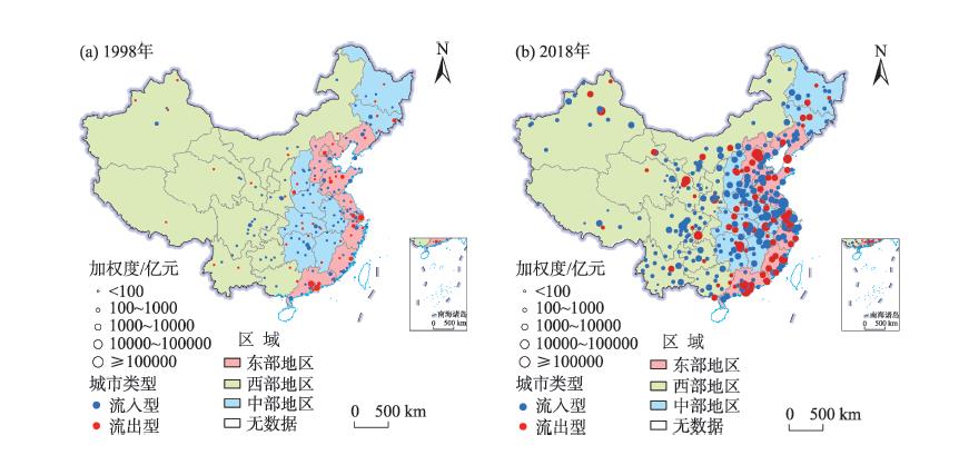
With the increasing economic interaction between cities, capital flow across regions has gradually become a key factor affecting the regional economic disparities. Cross-regional enterprise investment is regarded as the micro embodiment of capital flows. It is of great significance to explore the characteristics of cross-regional enterprise investment for reducing regional economic disparities. Thus, this study examined the cross-regional investment network using the cross-regional investment data of Chinese listed companies in 1998-2018, and analyzed the characteristics of the spatial evolution of China's cross-regional investment network and its influencing factors at the national and regional levels. The results show that: the spatial agglomeration trend of node centrality in China's cross-regional investment network at the national and regional levels is obvious and the cities with high node centrality are mainly concentrated in the five major urban agglomerations. There are obvious hierarchical structure, spatial heterogeneity, and path dependence of the cross-regional investment network; the net investment inflows and outflows are mainly in the eastern region, and the investment activities tend to develop toward the central and western regions; the influence of city economic development level, industrial structure, and financial environment varies across regions and types of cities with different population scales.
The Huhuanyong Line is a real portrayal of the spatial pattern of population, economic, and social development in China. It perfectly describes key characteristics of energy production and consumption. Quantitatively simulating the spatial pattern of energy consumption on the two sides of the line can provide a reference to achieve regional coordinated development. This study employed data from the China Energy Statistical Yearbook (2005-2014). We first constructed the System Dynamics Model Based on the Huhuanyong Line Energy Consumption Simulation Model (HLECSM-SD) using the
The study on the evaluation and spatial pattern of tourism eco-efficiency is an important basis for revealing the quality and state of tourism development at the provincial level in China. Based on a bottom-up approach to calculate tourism energy consumption and carbon emissions at the provincial level in China, this study used the Super-SBM (slacks-based measure) model, Malmquist index, and exploratory spatial data analysis to explore the spatial differentiation, convergence, and correlation patterns of tourism eco-efficiency at the provincial level in China in the context of energy conservation and emission reduction. The results show that: 1) Tourism energy consumption and carbon emissions generally show an inverted U-shaped trend that first increases and then decreases, which supports the environmental Kuznets curve (EKC) hypothesis. 2) The overall tourism eco-efficiency shows a fluctuating growth trend, and has great growth potential. Pure technical efficiency drives the optimized development of eco-efficiency. 3) At the provincial and regional scales, tourism eco-efficiency presents a spatial differentiation pattern, but tends to convergence and reach balanced development. 4) Tourism eco-efficiency presents a positive spatial correlation pattern from strong to weak, and its development model is dominated by low-low agglomeration, followed by low-high agglomeration, and the spatial agglomeration model needs to be optimized. All provinces and regions should take the areas with higher eco-efficiency as the benchmark, and realize the coordinated development of tourism with high quality by means of factor flow, scale effect, technological progress, and environmental regulation.
Urban-rural integration is an important support for the implementation of the new urbanization strategy and the rural revitalization strategy, while the reasonable flow and optimal allocation of urban-rural elements are the keys to the change of urban-rural relationship and urban-rural integration. Based on the theory of urban-rural regional system, this study examined the essence and connotation of urban-rural relationship from the perspective of elements, clarified the stages and general features of urban-rural relationship change, and then put forward its regulatory mechanism. The main conclusions are as follows: 1) Urban-rural relationship is the concentrated embodiment of urban-rural population relationship, land relationship, and economic relationship. The foundation of urban-rural relationship is the functional differences and complementarity between them and the representation is the flow of urban and rural elements. 2) The pattern of the development of urban-rural relationship is from differentiation to integration. Its evolution process can be generally divided into four stages: urban-rural differentiation, urban-rural opposition, urban-rural integrated development, and urban-rural integration. There are clear differences in the type, direction, ways, intensity, and degree of freedom of urban and rural element flow in different periods and regions. 3) Under the effect of economic mechanism and political mechanism, the flow of various elements constantly promotes the evolution of urban-rural relationship. The adjustment of urban-rural relationship should also continually improve and optimize the economic and political mechanisms.
With the increasing personalization of consumption, the development of new accommodation forms, especially sharing accommodations, is creating new economic growth points, while its interaction with traditional accommodations has attracted extensive academic attention. Using spatial autocorrelation and kernel density estimation, this study analyzed the spatial and temporal dynamics and spatial correlation of traditional and sharing accommodations in Shanghai, and explored the differences between them in terms of location selection factors by using the geographical detector. The results reveal that: 1) The spatial agglomeration of both traditional and sharing accommodations has increased significantly, but the spatial agglomeration of sharing accommodations has a tendency to rise first and then fall. 2) Traditional accommodations show a shift from a spatial expansion pattern dominated by contact diffusion to that supplemented by jump diffusion, while sharing accommodations show a spatial expansion pattern with contact diffusion and jump diffusion in parallel. 3) The positive correlation between the two has been growing during the study period, with the proportion of synergistic type increasing and the proportion of trade-off type gradually decreasing. 4) Sharing accommodations are more influenced by subway stations, public services, housing prices, and housing supply, while traditional accommodations are more sensitive to road density and regional economic development level. The differences and correlations between the spatial layout of traditional accommodations and sharing accommodations in different regional contexts and research scales deserve further exploration in the future.
With the vigorous development of sharing economy, shared accommodation has gradually matured, which has profound impact on the socioeconomic development in urban China. Despite the dramatic differentiation between the urban and rural shared accommodation markets, existing works focused on the spatial distribution and influencing factors of rural homestays, and shared accommodation research in urban areas is largely ignored. Shared accommodation in urban areas is closely related to urban tourism activities characterized by sightseeing, shopping, and cultural experience. This study obtained the data of the shared accommodations in Shanghai through Tujia (
The unique natural environment of the Qinghai-Tibet Plateau has restricted the construction and function of its transportation infrastructure. In order to evaluate the traffic facilities on the Qinghai-Tibet Plateau, taking Linzhi City, a typical area of southeastern Tibet with high altitude and uneven terrain, as an example and considering the natural characteristics, various transport modes, transport stability, and location advantage, this study established an evaluation system of comprehensive traffic advantage degree to empirically examine the situation in 2015 and 2020. The results show that: 1) Bayi District, Milin County, and Gongbujiangda County, especially their central towns, have much higher scores in internal traffic function, external traffic function, and location advantage degree, while the values of traffic advantage and many of its indicators in Chayu County and Motuo County are low, and the impact of some key transportation infrastructures such as the G318 Highway (national highway), Linzhi-Lhasa Highway, and Milin Airport is prominent. 2) The results of spatial difference analysis show that the comprehensive traffic advantage degree of Linzhi City is unbalanced, and the county-level gap and spatial polarization effect tend to increase. However, the core-periphery spatial structure is fragmented and interrupted by terrain factors of extreme difference in altitude, and the border area of Linzhi City becomes the weakest part with regard to the comprehensive traffic advantage degree. 3) There is a certain degree of matching between the comprehensive traffic advantage degree and the population distribution as shown by the linear trend line and coupling coordination relationship. Bayi District, Milin Town, and Gongbujiangda Town have reached the high-quality coordination level. However, most of the towns are at the preliminary or intermediate coordination level, while in the border area and areas with severe natural constraints, the coordination degree urgently needs to be optimized. Methodologically, by superimposing regional natural attributes, expanding the evaluation dimension of traffic advantage degree, and integrating various modes of transportation, the comprehensive traffic advantage evaluation conforms to the actual situation of the study area. Regional transport evaluation that incorporates the consideration of natural environment characteristics has practical significance for supporting territorial planning and transportation infrastructure evaluation and management, especially for regions such as the Qinghai-Tibet Plateau.
As the basic daily living space of urban residents, neighborhood has an important impact on people's life. Especially in recent years, with the common occurrence of residential mobility, the relationship between neighborhood environment and residents' subjective well-being has become more complicated. People's preference and choice of neighborhood environment are affected by the stage of their life courses. However, there exist few studies that explored the relationship between neighborhood environment and subjective well-being in different life course stages. Using the survey data collected in Guangzhou City, China, this study selected the samples with residential mobility behaviors in different life course stages, and constructed models according to the life course stages. The results show that the impact of the neighborhood environment on residents' subjective well-being is different in people of different life course stages. The cleanliness of the neighborhood public environment is more helpful for improving the subjective well-being of early youth, the harmony of the neighborhood relationship is more helpful for improving the subjective well-being of elderly residents, and the convenience of access to facilities can effectively improve subjective well-being throughout the life course. Residential mobility moderates the relationship between neighborhood environment and subjective well-being, especially in middle-aged and old age population. With the increase of residential time since the last move, the relationship between perceived neighborhood environment and subjective well-being is strengthened, while the impact of objective neighborhood environment is weakened. The improvement of neighborhood environment can more effectively improve the subjective well-being of short-distance migration residents.
The Hangzhou Bay, located in the Yangtze River Delta, is characterized by broad distribution of tidal flats and wetlands. As sea levels continue to rise in the future, natural hazards, especially storm surges, will be more likely to occur, which will have a great impact on the socioeconomic development of the region. Based on multi-year land use and assets data, this study conducted a simulation of the spatiotemporal change of elements at risk and exposures in the north bank of the Hangzhou Bay. The simulation is based on predictions of future variations in land use and assets and multiple extreme flooding scenarios, in order to assess the losses of flood disasters in the region. The results show that: 1) High values of asset losses per unit area under the current scenario appear in the south of Pudong New District. In future scenarios, high values of asset losses per unit area will cover the entire southern coastal area and the northern Jinshan District in the north bank of the Hangzhou Bay. 2) The entire study area will witness a growth in asset exposure and losses under extreme flooding scenarios as the GDP and the exposed and inundated area increase. The expected annual damage will rise from 65 million yuan under the current scenario to 304 million yuan under the representative concentration pathway (RCP) 8.5H scenario in the future. The risk assessment results indicate that the north bank of the Hangzhou Bay is susceptible to extraordinarily large floods. Thus, risk-sensitive urban planning must be implemented. The standards and specifications on residential communities and infrastructures in the region must be updated. Meanwhile, comprehensive preventive measures must be taken to enhance the flood control capabilities along the banks of the Hangzhou Bay. This study can provide a basis for decision making of risk-based urban planning, flood-risk adaption measures, and resilience improvements within the study area. The proposed research method is more reasonable and effective than the traditional methods of assessing future economic losses, which are often based only on current land use and asset values. It can also provide a methodological reference for risk assessments of other coastal regions.
The complex physical geography and human activities in large-scale hill-plain regions increase the difficulty of hydrologic cycle research and water resources evaluation and management. As an important tool for basin or regional hydrologic cycle simulation, the coupled surface water-groundwater model provides convenience for solving many hydrologic and water resources problems in large regions. To address the conflict between precision and efficiency of modeling, a new semi-loose coupled mechanism was proposed in the study, which embeds the 3D finite difference groundwater flow numerical model into a semi distributed hydrologic model (MODCYCLE). The mechanism abandons the current popular spatial and information conversion method between hydrologic response units (HRUs) and groundwater grid cells, but establishes the spatial association of subbasins and grid cells and the real-time information exchange between surface water and groundwater systems. The model was built and applied in the Sanjiang Plain. The calibration and validation of the model show that it has the ability to simulate the past and predict the future of the hydrologic cycle. Finally, the relationship of surface water and groundwater in the Sanjiang Plain from 2002 to 2014 was analyzed by using the model output. The results show that the increase of precipitation and agricultural irrigation led to an increase of 651 million m3/a of soil water storage in the whole region, but reduced the reserves of surface water and groundwater by 99 million m3/a and 303 million m3/a respectively. The increase of precipitation did not improve the attenuation trend of water resources caused by the rapid increase of water consumption. There were significant differences in the precipitation recharge coefficient and base flow index in different regions, which were the result of the combined action of natural and human factors. The results can provide references for the research of hydrologic cycle and the evaluation of water resources in this region.
Near surface air temperature is one of the most essential variables in a wide range of disciplines such as hydrology, meteorology, and ecology. Accurate estimation of air temperature for continuous spatial and temporal coverage is also crucial to climate change studies. Considering the sparse distribution of meteorological stations in Qinghai Province of China, this study estimated its near surface air temperature (Ta) based on meteorological observations, MODIS products, and SRTM DEM data from 2011 to 2019. First, daily instantaneous Ta under clear and cloudy sky conditions was retrieved from MOD07_L2 and MOD06_L2 products without the support of meteorological observations. Three parameterization schemes were used in this process and their results were compared. Second, these daily Ta estimates with highest accuracy were combined with meteorological observations and SRTM DEM data to generate high-precision monthly air temperature through the multiple regression method. Finally, the spatial and temporal distribution of Ta in Qinghai Province was analyzed. The results show that the accuracy of daily instantaneous Ta estimates can be improved significantly through averaging the near surface air temperature retrieved from MOD07_L2 and land surface temperature retrieved from MOD06_L2 without the calibration of meteorological observations. Specifically, the correlation coefficient (r) and root mean square error (RMSE) under clear sky conditions was 0.93 and 4.71 ℃, respectively; and the r and RMSE under cloudy sky conditions was 0.89 and 5.16 ℃, respectively. The multiple regression model with the calibration of meteorological observations provided a good estimation of monthly air temperature. The cross-validation results indicate that the determination coefficient (R2) and RMSE were generally above 0.8 and below 2.5 ℃, respectively. The high accuracy of monthly Ta estimation made it possible for us to investigate the spatial and temporal distribution of Ta in Qinghai Province. To be specific, the maximum and minimum monthly air temperature occurred in July and January, which was 13.59 ℃ and -9.44 ℃, respectively. Its spatial distribution was dominated by elevation. The average adiabatic lapse rate over the whole province was 4 ℃/km, which agreed well with the ground-based meteorological observations. The analysis indicates that MODIS atmospheric profile product holds great potential for all-weather air temperature estimation. The introduction of ground-based observations can reduce significantly the systematic error of air temperature estimation. The combination of MODIS products and ground-based observations proves to be useful for accurate air temperature estimation over large areas with complex topography.
The Alps, a typical mountain in the Eurasia Continent with mountain elevation effect (MEE), plays an important role in determining the geo-ecological pattern of Europe. The cause of the MEE is that the uplifted plateau or mountain absorbs more solar radiation. Most of the previous studies used the difference of temperature at the same altitude or base height inside and outside the mountain to quantify the MEE. However, the above methods may have some errors. This study chose the Alps as the study area and analyzed the spatial distributions of the solar radiation, temperature, and forest line in the Alps based on the collected meteorological observation data, forest line data, and digital elevation data, as well as the solar radiation data calculated by the hemispheric horizon algorithm. For the purpose of exploring the implication of MEE for the forest line, this study used solar radiation as the representation of MEE to build a forest line distribution model. The results show that: 1) The Alps has great MEE, and solar radiations of the inner mountain are much higher than that on the edge of the mountain. It is also the main reason that the temperature and the height of forest line in the inner mountain are far higher than that in the mountain edge areas. The solar radiation in the warmest month, the coldest month, and the whole year is 10-20, 20-40 and 200-400 kWh/m2 higher than that on the edge of the mountain, respectively. 2) Solar radiation can better quantify the MEE, and forest line distribution model established with solar radiations as the substitute factor of MEE has higher simulation accuracy. The accuracy of the forest line distribution model in this study (R2 = 0.736) is higher than that of the model based on temperature and precipitation (R2 = 0.522), and the contribution rate of solar radiation to forest line distribution is the highest (34.75% in January and 27.82% in July), which exceeds the contribution rates of temperature and precipitation (26.24% and 11.17%, respectively).
The tropics is the hotspot of global active fires. It is of great significance to reveal the spatial characteristics and dynamic changes of active fires for assessing regional biomass burning and carbon emissions. Based on the active fire vector data (2012-2019) of Visible Infrared Imaging Radiometer Suite (VIIRS) Suomi National Polar-Orbiting Partnership (S-NPP) provided by the NASA's Fire Information for Resource Management System (FIRMS), the occurrence density and agglomeration degree of active fires in Mainland Southeast Asia were quantified and analyzed using kernel density and spatial autocorrelation methods, in order to reveal the spatiotemporal variations in active fire occurrence frequency within the dry season, especially in February and April, during 2012-2019. The results show that: 1) The occurrence of active fires was dominated by low density (79%), and the high density areas had the smallest proportion (4%). Active fires are more likely to occur in economically backward countries (Cambodia, Myanmar, and Laos) and regions (for example, eastern Cambodia and northern Laos). High kernel density areas tend to distribute in high elevation, inland, and border areas in particular. Cambodia, especially its northeastern region, was always an area with high occurrence density of active fires in the study period. 2) The changes in medium density area of active fires were concentrated between January and April, which was mostly distributed around the low and high density areas, while the changes in high density areas were concentrated between February and April, spatially gradually shifted from northeastern Cambodia to western and eastern Myanmar, northwestern Thailand, and northern and southern Laos. 3) The density of active fire occurrence showed significant spatial autocorrelation in Mainland Southeast Asia and the five countries during the dry season. The spatial clustering types of the kernel density of active fires are dominated by "high-high" and "low-low" agglomerations in the dry season, especially between February and April. The local spatial autocorrelation of the kernel density of active fires in Vietnam and Cambodia is stronger than those in Thailand and Laos.
There exist two types of epistemology of materialism in current fields of geographies of consumption. One follows the principles of re-materialization on the foundation of dualistic dialectical materialism raised by Marx. Another school relies on the ontology of monism, relationality, and process, which also makes a profound impact on the understanding of geographies of consumption. The latter is classified into the school of thought of new materialism, which provides a more subtle and comprehensive understanding of the nonlinear relationships among places, subjectivities, the environment, material, representation, and so on, endeavoring to break up the long-standing dualism in former research in consumption geography. Thus, this study reviewed and summarized the research progress of consumption geography studies from the perspective of new materialism in order to bring a new ontology and epistemology. Drawing from the actor network theory (ANT), assemblage theory, more than human theory, and nonrepresentational theory, studies followed new materialism highlight material agency, dynamics, and impact on consumption networks. Furthermore, this article indicates the shifting connotation of geographies of consumption: Material in consumption not only acts as the entry point of investigating social relations among people but also actively engages in the process of consuming practices or even reshapes the consumption space; Subjectivities of consumers are produced in events, processes, and relations instead of only produced by social construction or discourse; Socialities are transformed from the linear relationship between consumers and producers to topological relations among consumers, producers, and other nonhuman subjects. On the basis of these shifting contents, this article concludes three different categories of the research process: embodied consumption practice and consumers' subjectivity; consumption space and affect; lively commodities and human-nonhuman-place relationship. At the end of this article, some reflections and outlooks are brought to fill in the gaps of current geographies of consumption in China. New materialism provides a new entry point in understanding subjectivities and socialities in geographies of consumption, especially insightful in solving transformation of consumption pattern and sustainable consumption; lively commodities and consumers' affect; Internet, technology, and reconstruction of consumption space.
A key challenge of social-ecological system governance is to effectively accumulate and transfer successful strategies across heterogeneous contexts. The context-dependence of social-ecological dynamics makes it extremely difficult to draw general conclusions about the determinants of effective governance. Generic design factors can be too abstract to be applied to concrete problems because every case is different. Archetype analysis is a particularly salient approach in this regard that helps researchers to understand and compare patterns of (un)sustainability in heterogeneous cases. This article clarifies the concept and characteristics of archetype, expounds on the significance of archetype analysis, and reviews the progress of archetype analysis in the key research fields of social-ecological system governance. The result reveals that: 1) Archetype analysis generally investigates recurrent patterns of the phenomenon of interest at an intermediate level of abstraction to identify multiple models that explain the phenomenon under specific conditions. 2) Archetype analysis is best conceived as a methodological approach, rather than a particular method, framework, or theory. 3) Archetype analysis can promote the accumulation and transfer of case study knowledge, is compatibility with multiple research methods, and can achieve a certain degree of predictability in social-ecological system governance. 4) Archetype analysis is based on "type-subtype" multi-level analysis, which helps to find the "strong" causality of the complex social-ecological system. 5) Archetype is not only the result of the research but also the starting point of the research. The test, modification, improvement, and validation of the archetype are also an important direction of future research.