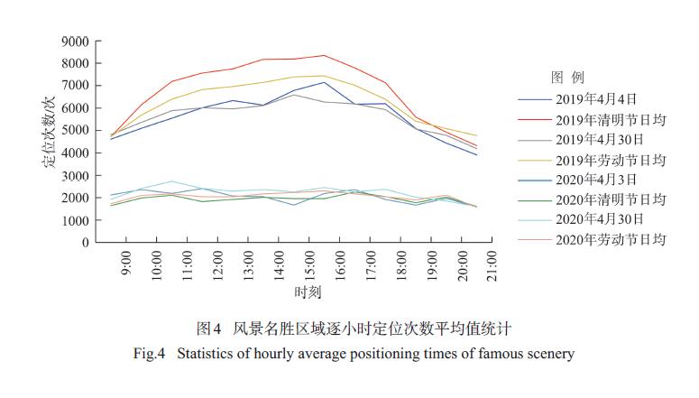
The Chinese government has curbed the outbreak of COVID-19 through a population flow control rarely seen in history. The COVID-19 pandemic has greatly impacted the recreation industry. Using mobile location data, this study quantitatively analyzed the impact of the COVID-19 pandemic on population heat map in the leisure areas within the Third Ring Road of Beijing City on the Qingming Festival and Labor Day. The results showed that: 1) The COVID-19 pandemic significantly impacted population heat map in leisure areas in Beijing on holidays, and the population heat map values of the three types of leisure areas investigated in this study declined by 54.2% and 53.0% on the Qingming Festival and Labor Day in 2020 as compared to the 2019 values, respectively. To be specific, the population heat map values of famous scenery, shopping services, and hotel accommodation decreased by 53.6%, 57.5%, and 52.9% on the Qingming Festival, and by 48.5%, 52.0%, and 55.6% on Labor Day, respectively. 2) There were differences in the degree of the impact on population heat map in different types of areas in famous scenery. The impact on the three major segments of famous scenery can be ranked in ascending order as follows: temples and churches (41.7%, 50.3%), parks and squares (53.1%, 47.1%), and scenic spots (61.1%, 51.2%). Wilcoxon rank sum test showed that the hourly variation of population heat map in temples and churches was smaller, and the overall demand can be ranked in ascending order as follows: sightseeing, daily leisure, and religious activities. 3) The 2020 population heat map of the leisure areas within the Third Ring Road of Beijing City was significantly negatively and positively correlated with the population heat map before the pandemic and area of these leisure areas, respectively. This can be attributed to the risk perception of the leisure crowds and the spatial and environmental factors of the disease prevention and control measures. This study provides a scientific basis for assessing the impact of the COVID-19 pandemic on leisure forms in big cities of China.
COVID-19 epidemic has brought major risks to the livelihood development of farmers, and livelihood capital is the key to resist the impact of the epidemic and prevent the crisis of returning to poverty. The data for this study were collected in 2020, with Hubei Province, Anhui Province, and Chongqing Municipality as the research areas. This study analyzed the role of livelihood capital of 465 households in the epidemic areas to resist the risk of the epidemic. Based on the Sustainable Livelihood Analysis (SLA) framework, this study evaluated the livelihood capital of rural households after the epidemic from the multi-dimensional perspective of structure-stock. The study adopted the endogenous switching regression model, based on different risk levels and capital dimensions, to identify the core factors that hinder the restoration of rural households' livelihoods. It is expected to help formulate follow-up livelihood assistance policies for farmers, improve the emergency response system for rural emergencies, and provide a decision-making reference for the introduction of measures to prevent return to poverty due to the epidemic. The study found that: 1) The total livelihood capital of farmers in the key epidemic areas is not high. The epidemic may induce economic vulnerability, and the development of grassroots public healthcare is also very important. 2) Livelihood capital has a significant effect of resisting the risk of the epidemic. Human capital has a stronger effect, and an excessively high proportion of physical capital will weaken the ability to respond to the epidemic. 3) The distribution of rural households' livelihood capital structure and stock is uneven. Household labor, health input, wealth accumulation, living environment, social experience, and so on are the core elements. 4) The recovery of livelihoods after the epidemic mainly depends on the accumulation of human capital and financial capital. The key to helping farmers in the epidemic areas lies in emergency response and basic social security. Differentiated and normalized epidemic prevention and control measures should be formulated according to the livelihood characteristics of farmers in different regions.
Fan economy is a rapidly emerging business in the Internet era. However, the existing literature lacks research on fan economy from a geographical perspective. Based on the theory of network space, and taking TikTok livestreaming commerce host as an example, combined with the influencing factors of e-commerce and urban amenity theory, this study constructed an index system of influencing factors affecting the spatial distribution of Chinese livestreaming commerce host. Using location quotient, global Moran's I, and cold-hot spot spatial analysis methods, we analyzed the spatial agglomeration characteristics of Chinese livestreaming commerce host, and the geographic factors that affect livestreaming commerce host distribution through spatial regression. The results indicate that: 1) China's fan economy shows a significant spatial agglomeration, and it is highly concentrated in the eastern coastal areas, with Guangzhou and Hangzhou as the most prominent. 2) The digital economy represented by livestreaming is reshaping China's original city tier systems. Cities with entertainment media, e-commerce, and characteristic tourism (such as Changsha, Jinhua, and Lijiang), are very attractive to livestreaming commerce hosts, even more than some first-tier cities (such as Beijing and Shanghai). 3) Through spatial regression analysis, it is found that the environment for e-commerce startups and cultural tourism have a strong explanatory power for the spatial distribution of livestreaming commerce hosts. The convenience of living and the natural environment also have an important impact, and the impact of human capital is small. At the same time, the number of patents has a significant crowding out effect on livestreaming commerce hosts, and livestreaming commerce has a strong grassroots nature. This research provides detailed empirical cases for in-depth understanding of the spatial process of fan economy and its influence mechanism and provides a reference for local governments to promote the development of digital economy and formulate talent introduction policies.
Accessibility of park green space is an important indicator of the livability level of a city. In order to solve the problem of scale imbalance between population and park green space distribution data by traditional accessibility analysis, this study used mobile phone signaling data to obtain the spatial distribution of population, and adopted the Gaussian two-step floating catchment area method to calculate the accessibility of park green space at the scale of traffic analysis zone (TAZ) in Shenzhen City. It also conducted a cluster analysis based on the accessibility results, supply and demand, and traffic conditions. The main conclusions are as follows: 1) More refined population information can be obtained through mobile phone signaling data to improve the accuracy of demand assessment. For different types of parks, the Gaussian two-step floating catchment area method represents an improvement in calculating the accessibility of parks in the city. 2) The overall level of comprehensive accessibility of park green space in Shenzhen is relatively high, but there is an obvious decreasing trend from the city center to the periphery. The mismatch between the accessibility of community parks and the supply and demand of park green space is an important reason for the large difference of accessibility among different regions in Shenzhen. 3) According to the results ofK-means clustering analysis, the TAZ units of the city was divided into low supply low demand low accessibility zone, medium supply low demand medium accessibility zone, high supply high demand medium accessibility zone, and high supply low demand high accessibility zone. 4) The accessibility of park green space can be improved by optimizing park layout, road construction, and residential area planning and layout. By improving data source and model of the traditional accessibility calculation, this study enriches the cases of park green space accessibility evaluation, and the proposed accessibility analysis method based on mobile phone signaling can also provide a reference for the accessibility analysis of other geographic phenomenon.
Mobility of persons with disabilities is an important aspect of equality of societies. Due to their special physical and socioeconomic conditions, the travel behavior of persons with disabilities has unique characteristics and is more susceptible to the impact of the built environment. Based on the smart card data of Wuhan rail transit, this study explored the spatial and temporal characteristics of rail transit trips of persons with disabilities in Wuhan City, and further explored the spatial heterogeneity of the impact of the built environment around rail transit stations on the passenger flow of persons with disabilities by using the geographically weighted regression (GWR) model. The findings are as follows: 1) 29.7% of the persons with disabilities who travel by subway show the characteristics of commuting, the frequency of travel on working days is higher than that on nonworking days, and they all show the trend of off-peak travel in the mornings and evenings. 2) Traveling is mostly within the short and medium distance of 15-30 minutes, and the range of activities is concentrated in the main city within the Third Ring Road, with the most frequent trips in the same area and few trips across the river. 3) In most research areas, bus stop density, road density, and large park density and opening time all have positive influence on the ridership of persons with disabilities. 4) The daily average ridership of persons with disabilities in transfer stations is significantly higher than that in non-transfer stations. 5) Different from the conclusions of previous studies, the mixed degree of land use and barrier-free facilities have no significant influence on the ridership of persons with disabilities. The result of this research can provide data support for the optimization of the built environment of disability-friendly subway stations and the land use of new stations, and enhance the people-oriented development of urban public services.
:A large number of studies has shown that there is a positive correlation between urban greenspace and residents' mental health. Urban greenspace is of great significance for improving mental health. However, existing studies mainly use cross-sectional mental health data, and cannot carry out causal analysis of mental health effects of greenspace. In addition, few studies control for the impact of community environment on mental health. Therefore, using a quasi-natural experiment and mixed-effect difference-in-differences model, this study explored the impact of urban greenspace intervention on residents' mental health by taking the East Lake Greenway in Wuhan City as an example. The results show that before and after the East Lake Greenway intervention, the mental health status of the residents in the experimental group increased significantly while the control group did not experience significant change. After controlling for the individual and community environments and other factors affecting mental health, the result indicates that the greenway intervention does promote the mental health of the surrounding residents. Finally, to effectively promote the development of mental health of urban residents, this article proposed that urban planners should build an integrated greenspace network to increase the accessibility of greenspace, optimize public transportation, and improve the social cohesion of communities.
Employment space reflects the diversity of urban economic and social phenomena, also provides fundamental basis for urban policy making and planning practice. Based on the longitudinal economic census database (2001-2013), this study employed empirical Bayesian Kriging, non-parametric locally weighted regression, multi-center density function, and other methods to examine the general spatial structure of employment in the Nanjing metropolitan area, as well as its changing locational patterns from structural employment dispersion, growth transformation of employment centers, and heterogeneous employment agglomeration with mixed land use. The results show that: 1) Employment suburbanization and polycentric development were remarkable in the Nanjing metropolitan area. 2) Employment density showed a trend of non-randomly structural dispersion. During the study period, the influence of the main urban center on the overall employment distribution weakened, while that of the sub-centers strengthened, but the former was consistently greater than the latter. 3) Employment centers underwent a growth transformation towards service and high-skill oriented. 4) There was a heterogeneous agglomeration pattern of employment and a positive correlation between mixed land use and employment density distribution. 5) The change of employment patterns was an outcome of the interaction between self-organization and outside influences, as well as between market mechanism and governmental behavior. Agglomeration economies, urban planning, and land market development were among the important influencing factors. The conclusion of this study has certain implications for the scientific planning of employment space of both the Nanjing metropolitan area and other cities.
Since the economic reform and opening up in the late 1970s, with the continuous deepening of institutional change, manufacturing industry in Changsha City has achieved rapid growth and development, and manufacturing space has also been reconstructed in the transformation. Taking Changsha City as an example, based on a quantitative analysis of industrial land vector data, and using spatial analysis, measurement index, and other research methods and incorporating the institutional changes into the dynamic analysis of urban manufacturing industry, this study explored the influence of institutional changes on the spatial evolution of manufacturing industry since the reform and opening up in 1978. It proposed an analytical framework for the evolution of manufacturing space under the influence of the institutional system. The results show that the suburbanization of the manufacturing space in the Changsha metropolitan area was obvious, and industrial clusters have been formed in the development zone. The spatial evolution of manufacturing industry in Changsha was largely affected by land policies, development zone policies, environmental protection policies, and industrial policies. Among them, the land policies accelerated the suburbanization of manufacturing space; the development zone policies attracted agglomeration of manufacturing industrial parks; the environmental protection policies restricted the scale of manufacturing development and promoted the outward migration of polluting enterprises; and the industrial policies affected the organizational structure of the manufacturing industry.
Based on the daily precipitation and NCEP/NCAR reanalysis circulation data provided by the NOAA/OAR/ESRL Physical Sciences Laboratory, and in view of the difficulties of rainy season monitoring in North China (the Haihe River Basin), this study established a specific humidity subtropical high method (QSH) for monitoring rainy season in the Haihe River Basin based on continuous meteorological variables and through contrast analysis and reasonableness analysis, and the variation of rainy season in the Haihe River Basin was analyzed. The main conclusions are as follows: 1) It is reasonable to monitor the rainy season in the Haihe River Basin by using the specific humidity-subtropical high method, which has good operability in practice. 2) The average start date of rainy season in the Haihe River Basin is 9 July, the end date is 19 August, and the length of rainy season is 41 days. 3) There was no obvious trend of long-term change of comprehensive intensity index, length of rainy season, and accumulated precipitation of rainy season in the Haihe River Basin during 1961-2019. However, there were obvious interdecadal variations, that is, the rainy season in the Haihe River Basin has a strong or weak periodic change every 18 years, which is in a weak period in recent years.
Improving the efficiency of water resource use and relieving water pressure are effective measures to solve the water shortage problem in the Beijing-Tianjin-Hebei region. An overall understanding of the historical situation of water use efficiency in various industries is conducive to future policy adjustments. In this study, we compared the comprehensive water use efficiency composed of six indicators, including water consumption per 10000 yuan of GDP, water consumption per 10000 yuan of industrial added value, water pipe network leakage rate, daily domestic water consumption per capita, sewage treatment rate, and water use efficiency of crops (WUE). Then the Mann-Kendall abrupt transition point and trend change of water use efficiency in the region from 2002 to 2017 were analyzed, and the periodic variation characteristics of each indicator were analyzed based on power spectrum estimation with the Burg method. The results show that, under the combined action of industrial structure optimization and adjustment and water-saving technology improvement, the differences of water use efficiency between the three areas of the region were gradually narrowing, showing the effect of coordinated development in the Beijing-Tianjin-Hebei region, but there were still significant development differences. The overall water use efficiency in Beijing and Hebei showed an increasing trend, and the growth rate of Hebei (0.16) was significantly higher than that of Beijing (0.07). The overall water use efficiency of Tianjin showed a decreasing trend (-0.03), which was mainly reflected in the increase of water consumption per 10000 yuan of GDP and water consumption per 10000 yuan of industrial added value (0.18, 0.19). In addition, water use efficiency in Beijing as a whole presented a cycle of about 5-year (77 dB) and 3-year (73 dB), while water use efficiency in Tianjin as a whole presented a cycle of about 7-year (88 dB) and 2-year (81 dB). Compared with Beijing and Hebei, Tianjin's comprehensive water use efficiency was more cyclical, which means that its internal cycle can be used to regulate the changing trend of water use efficiency in a timely manner.
A comprehensive understanding of the development status of erosion gullies and the urgency of their erosion control can provide an important reference for effectively identifying the direction and key areas of regional gully erosion prevention and control. Combined with the spatial data of erosion gullies, this study constructed an evaluation index of regional gully erosion control urgency. The distribution characteristics of erosion gullies in the black soil farming area of Hailun City in 2017 were analyzed at the town and township level and the grid level, revealing the extent of gully erosion and its spatial distribution patterns. The results show that: 1) Quantitatively, the distribution of erosion gullies in Hailun black soil farming area is unbalanced. The length of gullies is mainly micro/small (≤ 500 m), and the area of gullies is of class I and II (≤ 0.8 hm2). Overall, the erosion gullies are of large number, short length, and small area. 2) Spatially, the density of erosion gullies at the grid level gradually increased from the southwest to the northeast, while their dissected degree was mainly light, and there was no significant spatial difference across the area. The density of erosion gullies at the town and township level was mainly low, and the gullies were mainly distributed in the west of Hailun, while their dissected degree was mainly moderate/intensive and they are mainly distributed in the northwest and southeast of Hailun City. 3) The erosion control urgency of erosion gullies in Hailun black soil farming area in 2017 was mainly in the low urgency state, accounting for 67.06% of the area, which was mainly distributed in the plain and hilly areas, located in the western townships of Hailun; and the urgent/extremely urgent states were mainly found in the low mountain and hilly areas, located in the northeast of Hailun. In the planning of regional gully erosion control, the city government should give priority to the prevention and control of serious erosion areas according to the urgency state of town and township gully erosion control, while the town and township governments can carry out field investigation and key area monitoring according to the urgency of gully erosion control identified at the grid scale.
In the past 20 years, many paleohydrological investigations have been carried out in the Yellow River Basin. Based on the previous studies, this article systematically reviewed the progress of research on paleoflood events in the Yellow River Basin since the Last Deglaciation. Firstly, we reviewed the major findings on the identification of paleoflood events, the establishment of chronological framework of paleoflood events, and the climatic background of paleoflood events. Secondly, the reconstruction of peak water level and peak discharge of paleofloods and the social impact of paleoflood events were summarized. Thirdly, the main problems and recommendations in relation to accurate dating of paleoflood deposits, the causes of paleoflood events, and hydrological reconstruction of paleoflood events were proposed. Finally, we examined the prospect of future research in this field: 1) Strengthen the ability of modern flood monitoring, improve the understanding of flood-generating mechanisms, and then effectively evaluate the influence of hydrological model parameters on the result of paleoflood hydrological reconstruction. The ideal places (bedrock gorges) for paleoflood hydrological reconstruction, based on the paleoflood data, strengthen the research in the occurrence frequency and recurrence period of small probability extreme flood events, and enhance the ability of prediction and evaluation of major flood disaster events in the Yellow River Basin. 2) The whole Yellow River Basin needs to be considered for paleoflood study. We should strengthen the comprehensive analysis of paleoflood events in different time scales and reaches, especially the paleoflood events in the upper, middle, and lower reaches of the Yellow River. In addition, the paleoflood events in the Yellow River Basin should be studied synthetically from multiple perspectives, and paleoflood database needs to be established as soon as possible. This review may provide some historical basis for flood prediction, prevention, and risk assessment as well as ecological protection and high-quality development of the Yellow River Basin under the background of global change.
With the trend of "cultural turn" and "material turn", material geography has become one of the most active and burgeoning areas in social and cultural geography. Cultural geographers have turned their interests again to the material culture using an interdisciplinary perspective. Material geography has inherited the focus on humans and endeavored to get rid of the shadow of Fetishism since the "cultural turn". Its research focuses on the materiality, knowledge production, cultural identity, and social power relationship behind the material. Material geography's ontology, epistemology, and methodology do their revolution in response. For instance, "following the things" as a methodological perspective is brought up uniquely. To be specific, mobility is highly emphasized in the perspective of "following the things" because it sheds light on the human-place relations and different sociocultural contexts during the flow of things. Therefore, it is of great significance to do research on the material. In addition, considering the goal of completing the process of building a moderately well-off society in all aspects by 2020, we need to focus more on material's mobility and social value production in China in order to achieve great national development. However, there exist only a few reviews on material geography, and there is no review concentrating on mobility in material geography in China. In order to fill the gap, in this article we reviewed the history, necessities, and tendencies of the material geography research in the Western discourse, illustrating how the material geography studies achieve the transformation from "surface" material studies to representation studies, then to more-than representation studies. We also identified four main research themes in this area: 1) the symbolic meanings of material; 2) linking material and people's identities; 3) material production and consumption; and 4) the power game and negotiation behind the material. This article illustrated that material geography puts the sociocultural phenomenon into the wider political, economic, and cultural system to discuss, and deploys more creative and comprehensive methods to figure out what traditional methods fail to do. Finally, the article summed up the limitations of these studies and listed some possibilities for further research in China: international game and negotiation of power, construction and re-construction of commodity networks, and daily life geography. In short, our research seeks to enrich the material geography research in human geography in China and open the academic conversation with the Western world.
By reviewing the development of Western border studies at different stages, the current status of interdisciplinary border research, and the main terminology and practices of border research, this article discussed the logical link between the general theories and practices of border research in order to contribute to relevant Chinese studies and their improvement. The result indicates that the social construction of border has become the main paradigm of Western border studies, as the result of the cultural turn of social sciences and multidisciplinary integration. Furthermore, generic terminology for border studies, instead of unified theories, have formed, including complex border, the border of relations, the border of process, the border of transition zone, and the border of construction. The terminology, which stemmed from the practice in border areas, has facilitated the diversification of border studies on issues such as critical geopolitics, the border of social construction, and the border of scale. The implication of Western border studies for Chinese researchers is that it is necessary to promote interdisciplinary study, lay emphasis on the critical geopolitical research methods and how culture functions as a catalyst in border development. Further study on the paradigm of social construction is required. We should also strike a balance between theoretical research and practice and make them complementary to each other.