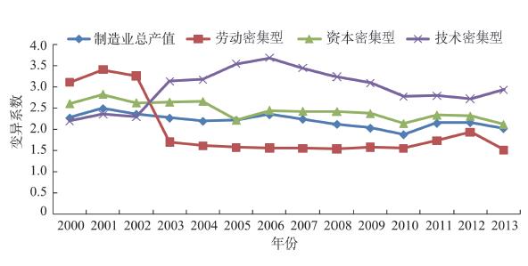
The development strategy of industrial transfer and upgrading, coordinated development, and in-depth integration of advanced manufacturing in the Beijing-Tianjin-Hebei region put forward higher requirements for the spatial layout of manufacturing industrial clusters. Research on the change of manufacturing industry spatial pattern can provide a reference for the optimization of urban agglomerations' advanced manufacturing industries. Based on the micro-level data of industrial enterprises above designated size in the Beijing-Tianjin-Hebei region from 2000 to 2013, this study used kernal density analysis and panel data regression models to explore the characteristics and driving factors of the change of the manufacturing industry spatial pattern in the region. The results of this empirical research show that: 1) The overall spatial pattern of all manufacturing industries in the Beijing-Tianjin-Hebei region is relatively stable, and high-value areas are concentrated in the Beijing-Tianjin-Tangshan area. The regional linked development of capital-intensive industries is gaining momentum; technology-intensive industries are increasingly concentrated in a few districts and counties, and the degree of spatial autocorrelation with surrounding districts and counties has weakened as a whole; spatial expansion into nearby districts and counties and spatial transfer of labor-intensive industries appeared alternately; and the regional linked development promotes the balanced growth of manufacturing industries in various regions and narrows the development gap. 2) The manufacturing industry in the Beijing-Tianjin-Hebei region shows a clear trend of specialization and regional division of labor, and labor-intensive industries are increasingly spreading to the periphery of the central cities and the counties in the central and southern areas of the region. Capital-intensive industries are concentrated in the industrial belt on the west coast of the Bohai Sea, the industrial output value of the peripheral areas of the region has increased significantly, and technology-intensive industries are gathered in the Beijing-Tianjin high-tech industrial belt. 3) The key driving factors of the three types of manufacturing industries are different. Labor-intensive industries are affected by investment and transportation accessibility. Capital-intensive industries are highly dependent on local market size and investment, and are insensitive to transportation accessibility. Technology-intensive industries are mainly constrained by transportation accessibility and wage levels. The three types of manufacturing industries are obviously affected by local fiscal expenditures.
Since the real estate industry is an important pillar industry of national economy in China, it is essential to understand its spatial pattern and location choice factors in Chinese cities to guide the healthy development of the industry. Based on business registration data of the real estate enterprises in Hangzhou City, this study applied spatial point pattern methods of nearest neighbor index, Ripley's K function, and nearest neighbor hierarchical clustering method combined with the geographical detector method to examine spatial agglomeration and location choice factors of real estate enterprises. The results show that: 1) Real estate enterprises and their sub-industrial enterprises in Hangzhou all exhibit a characteristic of spatial agglomeration, with the spatial agglomeration degree in the order of real estate agency > real estate development and operation > property management > other real estate industries. 2) Spatial agglomeration intensity of the real estate enterprises and their sub-industrial enterprises in Hangzhou first increased and then decreased, and their spatial agglomeration intensity and scale vary by different types of real estate enterprises. 3) Hotspot clusters of the real estate enterprises and their sub-industrial enterprises in Hangzhou are mainly concentrated in the areas around the West Lake and the Qiantang River, but there exist hierarchy and scale disparity of hotspot clusters for different types of real estate enterprises. 4) Geographical detector modeling results indicate that agglomeration factors, location factors, and traffic factors are the significant factors affecting the location choice of real estate enterprises in Hangzhou City.
Based on the data of 26 cities in the Yangtze River Delta during 2002-2017, this study analyzed the effect of high-speed rail (HSR) on producer services from both static and dynamic perspectives using the difference-in-difference model to explore the relationship between the high-speed rail and the spatial agglomeration of producer services. The results show that: 1) The effect of HSR is strongly associated with the development level of high-speed rails, and includes the organization of passenger traffic and space-time compression. The producer services agglomeration in the Yangtze River Delta has been greatly improved along HSR. According to the statistics from 2002 to 2017, HSR has actively contributed to the agglomeration of producer services, with the intensity increased during the development of high-speed rail network in the Yangtze River Delta. Temporally, the influence of HSR on producer services agglomeration can be categorized into two stages, exhibiting a lagging effect of the high-speed rail construction. 2) The effects of HSR vary for different industries, featuring significant heterogeneity. While facilitating the agglomeration of some industries among cities along HSR lines, HSR has contributed to the decentralization of other industries into cities without HSR stations. Research and design services belong to the highly-promoted type, which means that HSR promotes the agglomeration of research and design services in the cities with HSR stations. The second category is moderately-promoted type, which includes computer services and financial services. High-speed rail gears up the agglomeration of the above industries with different intensity. Energy saving and environmental protection services tend to be developed among cities without HSR stations, which is the same for transport services and productive leasing services. These three kinds of industries are classified as highly-restrained type, which has tendencies to locate in cities with no high-speed rail. The last category is the "no significance" type, containing wholesale and retail industry. 3) The impact of HSR on subcategories of industries exhibits heterogeneity across industries. From the dynamic perspective, the impacts on total producer services can be divided into two stages, corresponding to that of HSR development in the Yangtze River Delta. Besides, the dynamic effect of HSR is in accordance with its static effect on subcategories of industries.
Spatial structure measurement of residents' intercity trip network based on multiple perspectives can be used to comprehensively describe the complex connection between cities. Based on the data of population flow from Tencent migration platform in 2018 during the Spring Festival in China and using the complex network analysis method and taking alter-based centrality and alter-based power as indicators, the structural characteristics of Chinese intercity trip network under the three traffic modes of aviation, railway, and highway were compared and analyzed. The results show that: 1) The number of routes connected by aviation is the smallest among the three modes of travel, and the average trip distance is the longest; the number of passengers by railway is the largest, followed by highway and aviation. 2) With regard to the maximum dominant flow, Beijing and Shanghai play the most important controlling role in the domestic aviation trip connection, followed by Chengdu and Chongqing. With regard to the railway trips, Beijing and Chengdu occupy absolute advantageous positions, and the highways mostly connect provincial administrative centers and the surrounding cities. 3) There are four types of cities based on the alter-based centrality and alter-based power: high alter-based centrality-high alter-based power cities, high alter-based centrality-low alter-based power cities, low alter-based centrality-high alter-based power cities, and low alter-based centrality-low alter-based power cities. The number of high alter-based centrality-high alter-based power cities is the largest in the aviation and railway travel network. The number of high alter-based centrality-low alter-based power cities is dominant in the highway travel network. 4) There are differences in the number of urban community detection clustering structures under different travel modes. Aviation, railway, and highway were clustered into 7, 8 and 10 urban communities respectively. Under the aviation travel mode, discontinuity between "communities" is clear. Under the mode of railway travel, agglomeration appears, and an obvious block distribution appears under the mode of highway travel. From the perspective of travel modes, the characteristics of urban network are also significantly different. The intercity flow of aviation travel showed a core-periphery structure with national hub cities as the core; train travel showed a core-periphery structure with the cities along the national railway artery as the core, and gradually decreasing to the hinterland cities; and the intercity flow of highway travel indicates the spatial pattern of local strong aggregation matching the population scale. The study of spatial structure of residents' intercity trip network under different travel modes can reveal the multiple spatial characteristics of population migration, residents' trip, and urban network from different perspectives, complement the results of existing studies based on single travel modes, and enrich the regional understanding of spatial relationships of Chinese cities.
In order to solve the problem of unbalanced supply and demand of park green space in high density cities, this study used a Gaussian based two-step floating catchment area method to analyze the spatial accessibility of existing park green space in Huangpu District of Shanghai, under walking conditions. First, we extracted the point of interest (POI) data of residential areas from the Internet and aggregated them into a 100 m long hexagonal cellular network to calculate the number of people and population density, then through the Application Programming Interface (API) of Baidu Map we extracted the travel time between supply and demand points based on actual road conditions. Second, the paper took the park green space built by the end of 2018 in Huangpu District of Shanghai as an example, and considered the four aspects of residents' demand, accessibility classification, cold and hot spots, and blank areas. The results show that the accessibility level of park green space in Huangpu District is higher in the north and lower in the south, which is negatively correlated with the population density distribution. The dominant blind areas (9.16% of the total area) and the recessive blind areas (16.5% of the total area) should be eliminated. This study made a quantitative analysis on the supply and demand allocation, to provide guidance for the further optimization of green space layout and site selection. Finally, recommendations were made from three aspects of "increasing green space appropriately", "strengthening the quality of existing green space" and "community co-governance", in order to provide theoretical support for the Fourteenth Five-Year Plan of greening Huangpu District.
Industrial development is not only the basis of rural revitalization, but also an important breakthrough point to increase farmers' income and rural prosperity. Industrial development and farmers' livelihood depend on and influence each other, and the mechanism of influence is very complex. Examining the experience of agriculture industrial development in the area of ecological migration and analyze the impact of industrial development on farmers' livelihood is of great significance for promoting the revival of rural industry, the restoration of farmers' livelihood, and the sustainable development in the area. This study took Hongsibu District of Ningxia Hui Autonomous Region, the largest single immigrant area in China, as the study area, selected one village for each of the major rural industries, and used data from a questionnaire survey and semistructured interviews to examine the impact of agricultural industries on farmers' livelihood. On the basis of comparing the input-output of different industries, the impact of industrial development on farmers' livelihood output, livelihood capital, and livelihood strategy was explored. The results show that: 1) The agricultural industries in Hongsibu District has shown the characteristics of transformation from traditional extensive to high efficiency intensive agriculture, but the problems of short industrial chain and low ability to resist market risks and natural hazards and disasters are still outstanding. 2) Agriculture industrial development has an obvious effect on improving farmers' income, but the degree of influence is closely related to industrial types and farmers' participation. The total livelihood capital of farmers who have completed agriculture industrial transformation is much higher than that of other farmers, and there are obvious differences in livelihood capital structure. 3) The dominant livelihood modes of farmers in different specialized villages vary, and the support of agriculture industrial development to farmers' livelihood still needs to be improved. Under the background of rural revitalization, it is urgent to cultivate new business entities, guide small farmers to organically connect with modern agricultural industries, promote farmers' deep integration into the agriculture industrial chain and benefit for a long time, and fully release the diversified functions of agricultural industries. At the same time, the local government should continue to provide targeted assistance to farmers with difficulties in industrial transformation through financial support, technical training, trusteeship, and other forms of help to enable them to establish a sustainable livelihood system.
Studying on residential satisfaction of the new urban poverty space is of great significance for understanding the living condition of the urban poverty group, improving the life quality, and enriching the research of residential area. Taking the typical old enterprise communities in the central city of Xi'an as an example, this study explored residential satisfaction of enterprise communities and its influence factors based on survey data and structural equation modeling (SEM) method. Importance-performance analysis (IPA) theory was introduced to identify the priorities and sequence of enterprise community renewal, and we propose methods for the renewal of the old urban communities. The results show that: 1) Residential satisfaction of enterprise communities is at an average level, and the mean value of the 5-point Likert scale is 3.21. 2) Residential satisfaction is successively affected by the living environment, housing conditions, and supporting facilities, and has a significant negative impact on residents' willingness to move out. 3) There were significant differences in residential satisfaction among individuals with different socioeconomic attributes, such as age, educational level, household registration, occupation, monthly income, length of residence, housing property rights, and enterprise operation. 4) In order to improve the living conditions, it is necessary to give priority attention to the factors of community recreation and activity, sanitation, medical and nursing facilities suitable for the aged population, property services, public service facilities, and so on, and strengthen the sense of community belonging and cohesion of residents. It is recommended that the renewal of the old urban community in the future should be carried out from four aspects: management mode, living environment, housing, and supporting facilities.
As a large-scale landscape region, Tibet has ubiquitous and decentralized tourism resources, unique landscape, and layout of transportation routes. The various natural conditions such as terrain, altitude, and climate make tourist flows in Tibet completely different from other regions, especially for group and self-guided tours. This study collected data on group tour and self-guided tour from popular tourism websites, and combined social network analysis to explore the network structure characteristics and organizational models of tourist flows to Tibet, providing a theoretical reference for the optimal organization of Tibet tourism destinations. The study found that the tourist flow into Tibet is characterized by overall agglomeration and hierarchical differentiations. The nodes are not closely connected and the core-periphery structure is obvious. Group tour is strongly dependent on hub nodes and traffic, and self-guided tour covers a large area. Group tour and self-guided tour modes present "destination area loop" and dispersion features, respectively, and the phenomenon of crossing administrative regions in the compact network segment is prominent and largely controlled by the main traffic routes. The difference between tourist flows of group tour and self-guided tour reflects the joint influence of terrain, altitude, transportation, tourism resource distribution, and consumption ability. It is the result of spatial decision-making of individuals and groups under different tourism motives and the comprehensive effect of multiple factors, and has influenced the development of tourism transportation layout, tourism product combination, and regional tourism cooperation in Tibet. The research results provide a reference for understanding the flow and movement patterns of tourists entering Tibet for group tour and self-guided tour, and it can provide a theoretical guidance for the optimization of tourist route design and collaborative planning of tourist destinations in Tibet.
With the peaceful rising of China, the geopolitical relationship between China and the United States has entered the era of great game. Economic power is a key element in the Sino-US geopolitical game, but its spatial changes are rarely discussed. Based on the theory of asymmetric dependence and balance of power, this study constructed a fragility-sensitivity model of investment power and trade power, and dynamically revealed the patterns and trends of spatial changes of economic power of China and the United States. The research indicates that: 1) The economic power space of China and the United States has gradually evolved from US dominance in the world to a pattern where the eastern and western hemispheres are equally divided. 2) The area with spatially balanced power between China and the United States continues to shrink. The key areas of competition between the two countries have shifted from Asia, Africa, and Oceania to Europe and South America. 3) The changes in the space of economic power between China and the United States are diversified, which shows stable spatial viscosity and dynamic spatial oscillating coupling characteristics, forming stable areas, metastable areas, balanced areas, and bouncing areas. 4) The degree of international dependence of China and the United States on foreign investment and trade powers has significant spatial homogeneity and certain spatial heterogeneity. Both of them are dominated by double-high dependence and double-low dependence, forming various types such as investment-oriented dependence and trade-oriented dependence. 5) The Sino-US economic power balance zone shows obvious spatial difference, forming four types: peripheral isolation, energy endowment, economically developed, and strategic route. The strategic route regions are the focus of the political power game between the two countries.
Although climate warming reduces the frequency of frost, the longer growing season increases the vulnerability of plants to frost. At the same time, changes of vegetation phenology and primary photosynthetic productivity lead to changes in the vegetation greenup rate. The Greater Khingan Mountains is one of the most sensitive and earliest responding regions to climate change in China. Further study of the impacts of frost on vegetation greenup rates in this region is insufficient. This study reconstructed the vegetation greenup rate in the Greater Khingan Mountains, following which the responses of vegetation greenup rate to frost were analyzed in detail. National Oceanic and Atmospheric Administration (NOAA) Climate Data Record (CDR) Normalized Difference Vegetation Index (NDVI) data were used to study the spatiotemporal variations in vegetation greenup rates in the Greater Khingan Mountains from 1982 to 2019. This study used frost days and intensity indices to analyze the effect of frost on the rates of vegetation greenup from the beginning of the spring to the beginning of the peak vegetation growth season. The results show that during the study period, the frost days and intensity showed a downward trend, and the average decline rates were -0.24 ± 0.07 d/a and -0.036 ± 0.015 ℃/(d·a), respectively. Although decreases in frost days and frost intensity resulted in the acceleration of the greenup of forest ecosystems, the grassland ecosystem greenup rate was reduced at the same time. The response of vegetation greenup rate to frost differed among the different ecological regions. The response of vegetation greenup rate to frost events is obvious in the western forest grassland area (IIB3) and mountain deciduous and coniferous forest area (IA1) in northern Greater Khingan Mountains, and the partial correlation coefficients between the vegetation greenup rate and frost days were -0.42 (P<0.05) and -0.48 (P<0.01), respectively; and the partial correlation coefficients between the vegetation greenup rate and frost intensity were -0.49 (P<0.01) and -0.36 (P<0.05), respectively. This study highlights the effect of frost on vegetation greenup rate, and the results can provide a useful reference for understanding the response of regional vegetation to climate change.
Within the context of globalization and informatization society, inter-city competition is no longer bound to the scalar attributes of individual cities, such as geographic location, administrative hierarchy, population size, and so on, but rather increasingly depends on their positions in the division of labor and multi-scalar spatial functional linkages. Along with the current tendency of urban networking and clustering development, megaregion has become the spatial organization pattern with global significance in response to the present new competition and corporation situation. To understand megaregions in China, the differentiation and relationships between different concepts of urban functional regions in both Chinese and Western urban geography studies were systematically examined. The Chinese native concept of "Chengshiqun", as an urban region with flexible scale, is mostly similar to the concepts of mega-city region, megapolitan area, or megaregion in Western academic literature. To make it simple, we used the concept of megaregion to refer to the Chinese "Chengshiqun" in this article. In terms of the spatial meanings, we argue that a megaregion is: 1) a mega urbanized region consisting of more than two urban systems; 2) an urban system with both morphological continuity and functional cohesion; 3) a mega economic unit produced and shaped through the interaction of globalization and localization; and 4) a type of scale fix in today's urban and regional division and integration of labor. Specifically, the basic conditions for the development of megaregion mainly include high comprehensive carrying capacity of resources and environment, close spatial proximity of the metropolitan area to multiple single urban systems and compactness in geographic space, well-developed infrastructure networks, coordinated functional division and economic linkages, and relatively coherent social network and cultural identity. In future studies, we should pay special attention to exploring the spatial agglomeration effects and evolution of megaregions from the perspectives of relational geography and city network.
In view of the plight of spatial practice in the urban transformation of China, it is urgent to use the theoretical paradigm of spatial power and the value system of spatial justice to reflect on and reconstruct China's urbanization development model and its spatial governance. Urban political geography is based on the spatial power thinking of political geography, and draws on the research of urban politics and urban sociology on "urban politics" and "urban power" to expand the political attributes of urban space. However, based on China's national conditions and urban practices, it is necessary to explain the "political" meaning, "space" expression, and value orientation of urban political geography in China from a realistic level. Finally, on a realistic level, based on the "problem-driven" approach, this article put forward five important priority issues that should be paid attention to: urban spatial coordination game theory, urban institutional arrangements for spatial justice, value-based urban living space research, research on urban production space based on power, and research on urban ecological space based on responsibility.
In the context of global climate change, extreme weather events and the concomitant natural disasters are becoming a primary risk restricting the socioeconomic development in coastal areas that are often highly urbanized. This study sets out to explore the new characteristics of natural hazards and disasters in the coastal areas of China against the backdrop of a changing climate. Major conclusions are as follows. First, the occurrences of extreme weather and climatic events are considerably uncertain. The climate and disasters are different across various temporal and spatial scales, and the components of the disaster risk system become more complicated. Second, in view of the new challenges brought by climate change, we suggest paying close attention to three issues in the future, including the change of temporal and spatial scales that are used to depict the disasters, the synergism of multi-disasters, and the effects of climate change and urbanization. Based on these, a new framework of disaster risk system is established to reflect the qualities of disasters in complex spatiotemporal contexts. Lastly, to develop more effective coping strategies for the climate and natural hazards and disasters in coastal areas, it is necessary to promote diversification of the disaster prevention system and enhance its robustness, and to strengthen the self-recovery capability of the social, economic, and ecological environments. Meanwhile, information sharing in multi-disaster management and risk sharing and transfer policies are also important for accommodating the negative impacts of extreme events and disasters coming with climate change.
The relationship between urban and rural areas in China has been an important relationship for economic and social development and a major concern of the party and the government. In order to explore the relationship between urban and rural areas and its governance logic, the CiteSpace software was used to analyze the research hotspots of rural-urban relationship since the reform and opening up in the 1970s and to interpret its change based on the historical background, and then reveal the contextual characteristics of rural-urban relationship and the internal logic of governance reform. The research shows that since the reform and opening up, rural-urban relationship has gone through four stages—from an improving urban-rural relationship, to rural-urban re-separation, rural-urban relationship adjustment, and integrated rural-urban development. The process reflects the governance logic of breaking the rural-urban division, favoring the urban field, balancing rural-urban development, and promoting rural-urban integration. Since the 19th National Congress of the Communist Party of China, the relationship between urban and rural areas has developed in the direction of rural-urban integration. Rural-urban co-governance is the internal demand and governance trend of integrated rural-urban development in the new era. Finally, the article discussed the prospect of integrated rural-urban development and rural-urban co-governance from the aspects of abolishing the rural-urban dual system and establishing new supporting systems and mechanisms, breaking disciplinary boundaries and integrating interdisciplinary knowledge and cross-application of practice, and organically combining the two strategies of new urbanization and rural revitalization.