
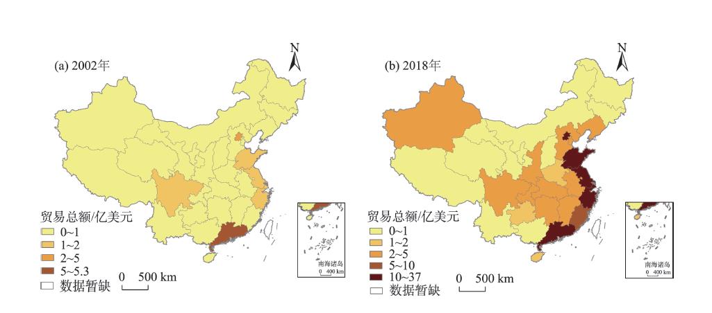
China-Pakistan Economic Corridor (CPEC) is the flagship project of the Belt and Road Initiative, and "unimpeded trade" is one of the priorities of cooperation in the Belt and Road Initiative proposed by China. It is important to examine the spatio-temporal characteristics of international trade between China and Pakistan for promoting economic prosperity and regional cooperation along CPEC. This study examined the spatio-temporal characteristics of trade cooperation between China and Pakistan, and analyzed its influencing factors using a stochastic frontier gravity model. The findings of this research are as follows: First, the scale of China-Pakistan trade is small but growing fast; China has trade surplus that continues to increase, and Pakistan shows low status in the global trade network of China; in China-Pakistan trade, China mainly exports capital-intensive products such as machinery and electrical equipment, and imports textile raw materials, textile products and other primary products, and labor-intensive products. Second, significant spatial differences exist in the trade scale and commodity structure of provinces in China with Pakistan; notably, eastern coastal provinces in China have significant advantages in terms of trade scale with Pakistan, while western provinces, except Xinjiang, have limited trade with Pakistan. Third, most of China's provinces have undergone significant changes in the structure of trade commodities, among which provinces with diverse commodity structures, such as Xinjiang and Shandong, have relatively little change. Fourth, higher economic development level and larger market size of provinces in China significantly promote China-Pakistan trade; shipping distance shows negative impact on China-Pakistan trade; shared border provides good conditions for cross-border trade; the construction of railway and shipping ports has shown a significant promoting effect on trade. Fifth, great trade potential still exists between provinces in China and Pakistan, especially in Inner Mongolia, Yunnan, Guangxi, and Shaanxi provinces and autonomous regions.
Clustering characteristics of COVID-19 cases within cities and influencing factors are of significant referential value for epidemic prevention and control. In this study, we conducted spatial clustering analysis, factor analysis, and regression analysis on 458 COVID-19 confirmed cases from 21 January to 24 February 2020, and we used mobile phone signaling data, and environmental data to analyze the spatiotemporal variability of epidemic characteristics in Chongqing Municipality at the residential community scale and the influencing factors. The results show that: 1) Temporally, the number of confirmed cases showed a rapid increasing trend in the beginning, and most of the cases were imported cases. In the late stage, the increase rate lowered, and the main trend turned into local transmission (including inter-community, intra-community, and intra-family transmissions), among which intra-family transmissions made up the largest portion (23%). 2) Spatially, the cases showed significant clustering characteristics, and aggregation level increased with time. The hot spots of all cases were distributed in the west and northeast Chongqing. The hot spots of local cases were mainly concentrated in the northwestern and southwestern regions where population density and economic development level were higher, while the hot spots of imported cases were mainly concentrated in the central and northeastern regions adjacent to Hubei Province. 3) The regression results between the density of all cases, local cases, imported cases and four factors obtained by factor analysis (urban traffic factor, intra-community activity factor, service provision factor, and residents' distribution factor) provide some insights. Transportation facility level was closely related to the density of confirmed cases. Service places such as stores, supermarkets, and restaurants significantly contributed to the spread of the virus. Inter-community transmission was an important factor in local clustering of cases, while imported cases mostly occurred in densely populated areas. Hence, targeted measures should be adopted for future epidemic prevention and control according to various epidemic transmission patterns in different regions, such as paying attention to imported cases in the central and northeastern parts of Chongqing, and focusing on avoidance of local transmission in northwest and southwest. Moreover, measures should be strengthened in the areas with dense urban traffic and resident population to effectively prevent the outbreak from rebounding.
As an important form of city relations, express logistics directly involves interurban material flows. Based on the data of multiple express logistics branches in 2019, this study analyzed the spatial pattern, characteristics, and structure of urban networks covering 336 urban administrative regions in China. The data were analyzed using GIS spatial analysis, social network analysis, Zipf law, and so on to reveal the features of China's urban system and regional development under globalization. The conclusions are as follows: 1) The spatial pattern of interurban logistics connection is hierarchical and imbalanced, and it shows the characteristics of westward decline due to the location conditions. 2) With regard to the overall connection, the density of the express logistics network is low and has a core-periphery structure, and the core area presents a small world characteristic with good accessibility and reciprocity. In addition, the intensity of agglomeration indicates the development trend of different urban agglomerations and reflects the radiation effect of core cities. 3) With regard to the local connection, provinces such as Guangdong, Zhejiang, and Jiangsu have formed high-level network connection and clusters, and promoted cross-regional flow of resources. 4) With regard to the individual networks, the degree of urban connectivity conforms to the Zipf law with a double fractal. In addition, economic and population scales have a strong correlation with urban connectivity, and city administrative level also plays an important role. However, express logistics companies still need to strengthen their service capabilities to reduce the risk of under capacity during the peak period.
Geographic proximity arising from industrial agglomeration can promote firm innovation and thereby industrial development. Scholars of evolutionary economic geography further propose that technology proximity is more important than geographic proximity, which provides essential theoretical support for explaining the role of interregional industrial linkages in local industrial development. However, the existing literature mainly focuses on the technological relatedness within regions but lacks research for interregional relatedness, especially the effects of interregional technology relatedness on regional innovation. Based on the input-output panel data of 2002, 2007, and 2012 from 30 provinces of the mainland of China, this study used the gravity model and cross-entropy method to fit the interprovincial trade flow matrix of the industries and further computed the index of intraregional and interregional technological relatedness. This study then used a two-way fixed effect model to examine the effects of intraregional and interregional technological relatedness on industrial innovation based on the data of 16 manufacturing sectors in 30 provinces in 2002, 2007, and 2012. First, the results show that the degree of interregional technological relatedness of industries has been strengthened, especially the linkages within city agglomerations. Second, interregional technological relatedness of industries has a positive effect on industrial innovation, but local technological relatedness of industries would weaken this positive effect. Therefore, the government should remove institutional barriers and encourage the inter- or intraregional industrial linkages that promote regional industrial innovation.
The classic theory of central business district (CBD) internal industry spatial distribution originated from the west, and its applicability in China needs to be tested empirically. Based on the micro enterprise data from 2000 to 2018 classified by machine learning, this study analyzed the industrial structure, agglomeration degree, spatial distribution characteristics, and so on in order to explore the spatial and temporal change and spatial agglomeration characteristics of service industry in Xinjiekou, a typical urban center CBD in China. The results show that: 1) The change of service industry structure in Xinjiekou shows that the number of productive services continues to lead, the growth rate of circulation services has slowed down, and the gap between consumer services and information services has widened. There is no trend of specialization in general; in comparison with the whole city, consumer services have stronger comparative advantages, and the advantages expanded over time. 2) The extent of agglomeration is divided. The change of the extent of industry agglomeration is reflected in the overall agglomeration of consumer service industry, social service industry, and information service industry, among which the highest extent of agglomeration is in catering, entertainment, and residential service industries. The retail industry is experiencing decentralization and shows an opposite trend compared with catering, entertainment, and residential services. The productive service industry has polarized. The financial service industry shows the trend of agglomeration and the research and development (R&D) and design service industry is experiencing decentralization. 3) The change of spatial distribution shows the trend of double zonal contraction as a whole. Productive service industry and consumer service industry are highly coupled. The cluster center of social service industry tends to move to the core, and circulation service industry and information service industry are gathering in the outer circle.
The distribution of Japanese foreign direct investment (FDI) companies in China is extremely uneven and these companies are highly concentrated in the Beijing, Shanghai, and Guangzhou-Shenzhen regions. Traditional FDI research has always focused on how urban attributes and conditions affect the location choice of companies. But the role of spatial agglomeration should be equally concerned. Existing research on agglomeration has shortcomings, such as homogenizing FDI and lack of detailed classification of industries, which lead to significant differences in the results of the studies. Whether companies will follow the investment location choice of other companies with the same source country has not received enough attention. At the same time, there is insufficient attention to the similarities and differences of typical urban agglomerations. To address these issues, based on the research of agglomeration and by focusing on typical cities where Japanese companies are concentrated, this study compared and analyzed the same industry agglomeration effect and the same source agglomeration effect. Using the FDI enterprise data of Japan in Beijing, Shanghai, and Guangzhou-Shenzhen in 1984 to 2017 and the multivariate logistic regression analysis method, with Guangzhou-Shenzhen as the reference region, we established the same industry agglomeration effect model and the same source agglomeration effect model, which includes seven equations each. Enterprise heterogeneity control variables such as industry and value chain links, entry mode, and entry time were added to the model to compare and analyze similarities and differences between Beijing, Shanghai, and Guangzhou-Shenzhen. The results show that the similarities and differences of the same industrial agglomeration effect and the agglomeration effects of the same source are obvious for Japanese companies in typical cities in China. Specifically: 1) Shanghai's same industrial agglomeration and cross-industry agglomeration are the most significant, and the results are stable. Guangzhou-Shenzhen's same industrial agglomeration is slightly stronger than Beijing, but the results are less robust. 2) The results of Shanghai's same source agglomeration are stable and significant and the agglomeration effect of enterprises is strong. The difference between Beijing and Guangzhou-Shenzhen is small. 3) The introduction of enterprise attribute variables has effectively improved the explanatory power of the model. The entry time of Japanese companies in Shanghai is earlier, and the overall size of enterprises across the country is not much different. The entry mode of Japanese enterprises in Shanghai is mainly sole proprietorship. In Beijing and Guangzhou-Shenzhen these companies are mainly joint ventures, but the increasing trend of sole proprietorship is obvious. The proportion of companies in the service industry is relatively high in Beijing, and the number of manufacturing companies is the largest in Guangzhou-Shenzhen. The Japanese companies in Guangzhou-Shenzhen and Shanghai focus on manufacturing or import and export trade in the industrial chain, and the number of companies specializing in business services and research and development is the highest in Beijing.
:Regional poverty is the focus of attention and research of the society, while the traditional study of poverty areas lacks attention to the southeast coast of China. Taking 64 counties in Fujian Province—a relatively developed coastal province in China's southeast coastal areas—as an example, this study constructed a measurement model of 30 indicators in three dimensions and nine vectors, and analyzed the characteristics of change and driving factors of county poverty degree in 2000 and 2016 by using the multidimensional poverty degree index (PI) and Kohonen neural network algorithm. The results show that: 1) The county development level of Fujian Province is typical among the southeast coastal provinces (Guangdong, Fujian, and Zhejiang). 2) According to the poverty degree index, the province can be divided into poor counties, disadvantaged counties, and normal counties. In general, poor counties and disadvantaged counties are found in the north and southwest, and concentrated near the peripheral areas of the province. 3) The change rates of the economic dimension, social dimension, and natural dimension of poverty indicate that most of the counties belong to the slowly deteriorating area, followed by counties with rapidly improving conditions, while the counties with slow improvement are few and scattered spatially. The change rate based on PI shows that the areas with slowly deteriorating conditions are distributed in the northern, central, and southwestern parts of Fujian Province, the areas with slowly improving conditions are distributed in western Fujian Province, while rapidly improving areas are distributed in the east coast of Fujian Province. The poverty of most poor counties are caused by economic, natural, and other factors, which have important influence on the process of poverty alleviation. 4) In 2000 and 2016, medical and health care, education level, living environment, and economic development deeply affected the contribution rate of PI. Strengthening the development and provision of public services such as infrastructure, medical and health care, and education should be the focus of current poverty alleviation efforts in Fujian Province. At the same time, the ecological environment and resource endowment also play a part in poverty alleviation. 5) There are four types of poverty factors based on contribution rate of poverty degree in different vectors: Type I is dominated by education and infrastructure, type II is dominated by economic development and living environment, type III is dominated by demographic characteristics and infrastructure, and type IV is dominated by health care and economic development. This study can be of some reference for the identification of poverty counties, and may contribute to the implementation of targeted poverty alleviation strategy.
Stability of cropping intensity of the cultivated land is related to the national food security of China, and it is of great significant to obtain detailed process information of the spatiotemporal change of cropping intensity in a timely and efficient manner. Based on the MODIS09A1 data of 500 m resolution in 2001-2018, this study mapped the spatiotemporal distribution of the national cropping intensity by using the fast automatic detection method of continuous wavelet transform, and examined the spatiotemporal change of cropping intensity and driving mechanisms by Mann-Kendall nonparametric test and heuristic segmentation method. The results show that the cropland multiple cropping index in China had risen steadily, and the average value of multiple cropping index had increased from 1.14 in 2001 to 1.30 in 2018. In 6% of the country's cultivated land area (about 135000 km2, equivalent to the area of Anhui Province), multiple cropping index changed significantly. The areas with multiple cropping index increase account for about 2/3 of the total area of multiple cropping index change, and the areas with decreased multiple cropping index account for about 1/3 of the total area of multiple cropping index change. The key regions with positive change are the Loess Plateau and the Gansu-Xinjiang region (from fallow to single cropping), and the Yellow River-Huai River-Hai River region (from single cropping to double cropping), and the changes mainly took place in 2004-2013. Since 2013, the national multiple cropping index has continued to increase. An important contributing factor is the continued increase in area of double cropping (converted from single cropping), which was mainly in the Yellow River-Huai River-Hai River region. Negative change mainly took place in the middle and lower reaches of the Yangtze River Basin where double cropping was partially replaced by single cropping in 2009-2013. Maintaining effective planting area of the cultivated land in the Loess Plateau and the Gansu-Xinjiang region and double cropping planting area of the cultivated land in the Yellow River- Huai River- Hai River region, and preventing the decline of multiple cropping of the middle and lower reaches of the Yangtze River Basin are of great significance for stabilizing the multiple cropping index and ensuring food security in China.
Based on the 1980, 1990, 2000, 2010, and 2016 panel data at the town and township level on the Loess Plateau, this study analyzed the population and accessibility scale structure, hierarchical system, and allometric scaling by using rank-size distribution and allometric growth model of the fractal theory. The results show that: 1) Population size was mainly small and medium, and population of 60% of the towns and townships was growing at a positive rate. The distribution of population presented a pattern of "high in the north and south, and low in the middle". Potential accessibility on the Loess Plateau tended to increase over time and the spatial distribution of potential accessibility gradually decreases from southeast to northwest. Population and potential accessibility of valley plains both are the highest. 2) The rank-size distributions of population and accessibility comply with the power-law relation, and both present a log-normal distribution. The distribution of population size changed from equilibrium to polarization, and the distribution of potential accessibility tended to be further balanced. The population rank-size distribution was characterized by dual fractals from 1980 to 2016, while the accessibility rank-size distribution had evolved from dual fractals to single fractals with 2000 as a turning point. Accessibility scale distribution tended to be stable. 3) The characteristics of population-accessibility allometric growth were clear. The 3006 towns and township mainly showed positive allometry, supplemented by negative allometry. The allometric growth types of towns and townships in the gully areas of the Loess Plateau and the valley plains were dominated by positive allometric growth with population growth. The allometric growth types of towns and townships in the hilly-gully areas of the Loess Plateau, sandy and desert areas, and earth-rock mountain areas were dominated by negative allometric growth with population decline. The irrigated regions were dominated by positive allometric growth with population growth and negative allometric growth with population decline. Finally, according to the population and accessibility allotypes and spatial distribution characteristics, some policy recommendations for the development of each region are put forward.
Urban pluvial flooding is an increasing problem for cities worldwide. Urban spatial growth and development have been widely recognized as one of the most important contributors to the increasing risk of flood disasters. Using Wuhan City, China as a case, this study developed a binary Logistic model to quantify the impacts of urban development on flooding under different rainfall scenarios (regular and extreme), especially the role of land conversion from water areas. Based on historical remote sensing data, the analysis of the dynamic land use changes indicates that over 30% of water areas had been converted into urban construction lands from 1984 to 2017. The results show that the conversion of water areas severely intensified the flooding risk of the surrounding locations in the extreme rainfall scenario. In addition to this land conversion, elevation, drainage conditions, land use types, and land use of surrounding areas are also significantly correlated with urban flooding. Based on two land use and development strategies, the risk maps of future flooding were predicted under regular and extreme rainfall scenarios. These maps show that the development of the remaining vacant lands will induce even worse flooding. Adaptation strategies corresponding to different land use types are provided according to the predicted flooding risks. The model could help develop adaptation strategies and policies to cope with future urban flooding by exploring its driving factors.
From the perspective of new cultural geography, space not only carries material attributes but also represents a container of social relations. Family is usually discussed in terms of ethics and regarded as an ethical organism. However, family always takes the form of spatial entity that reflects a complex and subtle power structure among its members. Using the framework of the economic, emotional, and social components of family resources as well as the practical, decorative, and defensive characteristics of home space, this study examined how Vietnamese wives of the transnational families in Huashi Town, Luoding City, Guangdong Province practice self-empowerment in everyday life by occupying, dividing, decorating, and utilizing their home space. The study found that: 1) The Vietnamese wives who contribute most to their household incomes have more power than their husbands in making decisions about the set-up and arrangement of the home space. 2) The Vietnamese wives view their home space as a channel of expressing self-emotion and identity and establish control of the space by decorating the home. 3) Being excluded from the public space due to the lack of social resources, the Vietnamese wives use their home space as a defensive fortress to avoid socializing with neighbors. It is suggested that while women in transnational marriages are able to exert power in their home space, such power is confined within the home and difficult to expand to the outside world. The study contributes to existing literature of cultural geography by deepening the current understanding of gender in home space.
The relative importance of regional specialization and diversity has been under constant debate in the field of economic geography. At present, China has entered a period of transformation and upgrading, changing its economic growth momentum. It is necessary to understand and evaluate the spatial effect of industrial diversity in order to choose a reasonable path for regional development. In view of the internal relationship between industries, evolutionary economic geographers divided diversity into related variety and unrelated variety according to the degree of correlation between industries, which provide a new analytical framework for explaining the internal mechanism of regional economic effect of variety. This article summarized the concepts and measurement methods of variety, and discussed the relationship between different types of variety and regional economic development and its internal mechanism. Through a literature review, it is found that related variety and unrelated variety play an important role in improving regional productivity, resisting external shocks and maintaining stability, and promoting employment, innovation, and other aspects through knowledge spillover and portfolio effect, but the process is relatively complex. Considering industrial characteristics, regional scope, location, development stage, and other factors, there is a nonlinear relationship between variety level and regional growth. It is proposed that the focus of future research should begin from the following aspects: 1) Expand the meaning of relatedness to define variety in a broader sense and further consider the role of the relatedness of other factors, such as market and institutional variety, in the spatial effects of regional variety, while not only limiting it to similarities but also taking into account complementarities. 2) Further examine how firms and actors at the micro level discriminate and absorb knowledge from related and unrelated industries, and how multiple forms of proximity affect the knowledge restructuring process in related and unrelated domains. 3) Fully consider the characteristics of regional heterogeneity and the scope and conditions of regional variety at different temporal and spatial scales to provide theoretical support for the effective implementation of policies in different administrative divisions. 4) Existing studies are mostly based on the experience of Western countries, lacking an overall assessment of related and unrelated diversities in China and its pattern of change over a long period of time. It is necessary to take full account of the institutional contexts of different countries in order to further deepen and complement the theoretical framework and research results of evolutionary economic geography.
The concept of sharing economy that is based on the new information and communication technologies has spread all over the world in recent decades. The encounter of technological innovation and the very traditional ideas of sharing has stimulated various forms of new economic growth. By changing the consumers' behavior in massive scale, the sharing economy also has a great impact on the urban economy and space. The rising of sharing economy and its various forms of business will surely impose a great impact on urban development. Being a typical sector of the sharing economy, the sharing short-term rental platform (SSRP), represented by Airbnb, is reshaping the traditional tourism and urban housing market since its early stage of development. To deliver a review of literature on the topic, this article first recalls the emergence and development of the concept SSRP, as well as the controversies caused by it. Second, by placing SSRP in the context of the traditional domains of hotel industry and urban housing market, the article explains the overlapping areas of the three domains, and what the impact of its further commercialization might be. Finally, through the analysis of a large number of empirical cases, the interactive relationship between SSRP and urban space is revealed. On the one hand, the socioeconomic and environmental factors in urban space determine the spatial distribution characteristics of the SSRP listings; on the other hand, the SSRP will gradually change the urban socioeconomic and environment space by tourism gentrification, the change of commercial structure, and the increased burden on urban facilities.
The freezing and thawing processes of near-surface soil are one of the most significant physical characteristics of the land surface on the Tibetan Plateau (TP), as well as an essential index for estimating the existence and development of the permafrost and reflecting the climate change. The seasonal and diurnal freezing-thawing processes of the near-surface soil cause the changes and even anomalies of water and energy balance between the land and the atmosphere on the TP, and thus significantly affect surface hydrological processes, ecological environment, carbon and nitrogen cycles, and the weather and climate system on the plateau and of the surrounding areas. This article discusses the observational and simulated changes and the impact on the climate by reviewing latest research progress in soil freezing-thawing processes (SFTPs) over the past 20 years. Our review shows that: 1) During a complete annual freezing-thawing cycle, each layer of soil generally experiences four stages: summer thawing period, autumn thawing-freezing period, winter freezing period, and spring thawing-freezing period. Due to the influence of local factors, the SFTPs show differences in the start and end dates, rate, and type of change. 2) Diurnal freezing-thawing cycles show large differences between the permafrost regions and the seasonally frozen regions, which are mainly reflected in the duration of diurnal freezing-thawing cycles. 3) Although different land surface models (LSMs) can well capture the spatiotemporal variations of physical quantity of SFTPs, all of them need to be revised according to the characteristic of LSMs of the TP. 4) Unreasonable freezing-thawing model parameterization schemes can be improved through avoiding the unstable iterative computation and determining the critical freezing-thawing temperature according to the thermodynamic equilibrium equation. According to the review of existing research, adding high-quality observation stations, using satellite remote sensing data to retrieve SFTPs and deepen the coupling of LSMs with regional climate models and global climate models, developing parameterization schemes that are suitable for SFTPs of the TP, and adjusting the model structures can be helpful for the simulation of SFTPs on the TP.