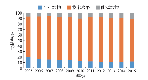
Research on the driving forces of the change of CO2 emissions intensity inequality in China could provide a scientific basis for formulating sound, fair, and efficient regional carbon emission abatement strategies. This study adopted the Theil index to measure the inequality in energy-related CO2 emissions intensity in China during 2005-2015, and conducted source decomposition focusing on geographical regions, economic sectors, energy types, and explanatory factor decomposition of the inequality. The results show that China's CO2 emissions intensity gradually decreased from 2005 to 2015, but the provincial gap continued to expand. From a regional perspective, the inequality in CO2 emissions intensity is mainly found within China's northeastern, eastern, central, and western regions. Besides, the ever-expanding internal differences of CO2 emissions intensity within the eastern and the western regions increasingly became the main driver of the inequality enhancement. The industrial sector and coal were respectively the major sources of CO2 emissions intensity inequality in terms of economic sectors and energy sources, which were also the key drivers of the intensity inequality exacerbation. With regard to the determinants, the provincial differences in CO2 emissions intensity were mainly dominated by the technological development level, followed by the industrial structure and energy structure. Among them, the widening provincial differences in technology level and energy structure enhanced the inequality in CO2 emissions intensity, and the contribution of technology level was much larger than that of energy structure. The narrowing disparity among provinces in the industrial structure, however, promoted the reduction of the provincial CO2 emissions intensity inequality in China. The research results can provide a scientific basis for the formulation of China's regional emission reduction strategy.
Examining the difference in the impact of regional government intervention on carbon emissions is of great significance for China to promote carbon emission reduction strategies and coordinate regional economic and social development. In view of this, based on the local government industrial land transfer data and taking China's eight economic zones as examples, this study used the organic coupled CO2 environmental Kuznets curve (CKC) model and the stochastic impacts by regression on population, affluence and technology (STIRPAT) model construct the STIRPAT expansion model, and used the industrial panel data of 28 provinces (municipalities and autonomous regions) from 2007 to 2016 to compare and analyze the differential impacts of government land transfer intervention on industrial carbon emissions. The research results show that there are significant differences in the impact of government land transfer intervention on regional carbon emissions in different economic zones. Among the eight zones, the northern coastal, southern coastal and the middle reaches of the Yangtze River economic zones have the same inverted-N type CKC. However, the impact of government land transfer intervention on regional carbon emissions shows the different effects with the northern coastal economic zone as negative, the southern coastal economic zone as positive and the middle reaches of the Yangtze River economic zone without significant effect. The northeastern, southwestern and northwestern economic zone have the same inverted-U type CKC, and government land transfer intervention has a significant negative impact on regional carbon emissions in the northeastern, southwestern economic zone, while insignificant impact in northwestern economic zone. The eastern coastal region and the middle reaches of the Yellow River have the same U type CKC, and the government land transfer intervention on carbon emissions also show the opposite effects, with the former being negative and the latter being positive. The result of the analysis may provide a reference for differentiated energy saving and emission reduction policy and regional coordinated sustainable development.
As an economic phenomenon characterized by the interaction of self-governance of development and regional competition under the framework of administrative divisions, "administrative regional economy" (ARE) has a profound impact on regional coordinated development. With the perspective of regional economic integration, this study constructed an ARE measurement model (AREM) based on ARE function and improved potential model, and took the Chengdu-Deyang-Mianyang region as an example to quantitatively describe the spatiotemporal evolution of the constraint strength of ARE from 2005 to 2018. The results show that: 1) In 2005-2018, ARE of the study area experienced three stages of development—overall rise-rapid decline-fluctuation, and the rigid constraint of administrative divisions on economic integration generally declined, with a clear regional integration trend. 2) 2009 was the inflection point (peak) of the ARE change, and the various stages of the ARE change were strongly coupled with policy and administrative division adjustments, indicating that AREM has reasonable applicability. 3) The transition of ARE type steadily took place during 2005-2018: high-intensity and 60% of medium-intensity cities transformed into low-intensity cities, and the proportion of low-intensity cities increased from 51.7% to 91.4%. This shows that ARE has decreased significantly and the level of regional integration has increased. 4) The spatial pattern of ARE in the study area experienced the process of central polarization-central to peripherial decline-peripheral collapse, and effective measures were taken in terms of regional coordinated development with remarkable results, which promoted the displacement of ARE's center of gravity to the south (3° west) by 10.08 km. In the future, it is necessary to optimize the regional system of the Chengdu-Deyang-Mianyang region by reforming the administrative structure and timely promoting the adjustment of administrative divisions, weakening the restriction of administrative divisions, and building an integrated development model.
Rural tourism is considered an effective mode of rural revitalization in mountainous areas, but even in mountainous tourist areas, there still exist a large number of traditional rural areas. Taking Pingyang County of Zhejiang Province as an example, this study used participatory rural appraisal method and GIS and remote sensing technologies to compare a typical tourist village (Shuikou Village) and an agricultural village (Fahong Village). This study analyzed the rural development and its differentiation in mountainous areas with tourism characteristics from three aspects: the change of farmers' livelihood, the transformation of rural land use, and the functional change of homestead. The results show that: 1) During the survival livelihood stage (1949-1977), the two villages were highly dependent on agriculture for livelihoods; During the combined livelihood stage (1978-2013), the two villages changed from a single agriculture-oriented livelihood to a combination of agriculture and migrant worker livelihood; During the development-oriented livelihood stage (2014-2018), Fahong Village mainly depended on migrant workers, while Shuikou Village formed a livelihood structure that attached equal importance to tourism and business. 2) Before 1978, land use change in the two villages was mainly from forest land to cultivated land. Before 2014, land use change in the two villages was mainly conversion from forest land to construction land. After 2014, Fahong Village mainly converted cultivated land to forest land and residential land, while Shuikou Village mainly converted forest land and cultivated land to tourism-related land. 3) Before 1978, the functions of homesteads in the two villages were mainly agricultural production. Before 2014, the agricultural production function of homesteads in both villages had begun to decline. After 2014, homesteads in Fahong Village are dominated by living function while those in Shuikou Village are dominated by tourist reception function. 4) The development of the two villages into different land use and livelihood strategy types is the result of the comprehensive influence of natural environment, human landscape, elite leadership, market changes, among others. The study shows that even in the mountainous areas with tourism characteristics, only those villages with unique natural and human landscapes and capable people to lead and adapt to market changes can better develop rural tourism. Most of the villages with ordinary resource endowments are still dominated by traditional agricultural economy. Therefore, rural revitalization in mountainous areas should consider local environmental and resource conditions and select villages with favorable conditions to promote targeted development.
Under the background of a large population and scarce land resources and the dual structure of land property right, the cultivated land resources in China have been the lifeline of farmers, and their social security function is considered the stabilizer of society. But this view has been increasingly questioned in recent years. The capability of cultivated land as a security for farmers depends on its assets value. In the past few years, the phenomena of cropland abandonment and rent-free land transfer became increasingly prominent, indicating that the assets value of cultivated land in some areas has declined. Therefore, it is urgent to acquire detailed data in order to systematically and quantitatively examine the social security function of cultivated land assets for Chinese farmers. Taking the cultivated land with contracting rights as an asset for farmers, this study selected four agricultural regions (suburban agriculture, intensive agriculture, plain field agriculture, and mountain agriculture) and 1025 farming households in a survey to reveal the spatial differentiation characteristics of the social security function of cultivated land. The results show that: 1) As a means of production, there are significant differences in the yield from cultivated land assets in different agricultural regions. The proportion of the yield from cultivated land in household total income is no more than 50% and only less than 7% in mountainous areas. 2) For old-age security, there is also a big difference in different agricultural regions. The contribution rate of cultivated land as old-age security is less than 30%, and it is less than 3% in mountainous areas. 3) With regard to its financial mortgage function, taking the 200000 yuan capital demand for a farming household as an example, the average eligible loan amount from cultivated land assets meets no more than 20% of this need, and only 1% in the mountainous areas. At present, the social security function of farmers' cultivated land assets is very limited, and the social security theory of cultivated land needs to be re-examined. This will help us to make scientific judgments on the rural land security function in the new era. With the continued advancement of urbanization, the yield and assets value of cultivated land for farmers show persistent differentiation in different agricultural regions, especially due to the marginalization of cultivated land in mountainous areas. How to slow the cropland abandonment and depreciation of cultivated land assets in mountainous areas needs to be researched during the implementation of the rural revitalization strategy.
:This study examined how high-tech parks promote the development of intelligent industrial clusters, and summarized the current research on the evolution and agglomeration of intelligent industrial clusters. First, the concept and classification of intelligent industrial clusters in high-tech parks are defined based on the existing classification standards of the information industry. Second, the intelligent industrial clusters of the Zhongguancun Science Park and the evolution of the spatial layout and industrial growth were analyzed based on the statistical data from 2002 to 2016. Using the Porter classic diamond model as a theoretical framework, dynamic factors of the evolution process were analyzed, resulting in a diamond model of the subdivision dynamic factors for the evolution of the intelligent industrial clusters in the high-tech park. Third, the main agglomeration models of the intelligent industrial clusters in the Zhongguancun Science Park were refined based on the main dynamic factors. The main conclusions are as follows: 1) The evolution of intelligent industrial clusters of the Zhongguancun Science Park showed a coordinated development pattern of "one core and multiple parks" resulting from policy guidance and then natural overflow, radiating and aggregating from the core area of Haidian District to surrounding science parks, and gradually forming a coherent development into non-policy areas based on the production factors such as traffic and buildings between the science parks. 2) As the core area, Haidian District attracted various types of intelligent industries and, conversely, the other science parks have formed agglomeration advantage of specific types of intelligent industry. 3) The evolution of intelligent industry in the Zhongguancun Science Park was mainly affected by three factors—production factor, influence of government policy, and related and supporting industries. 4) There are three agglomeration models of intelligent industrial clusters of the Zhongguancun Science Park—production factor driven, industrial platform driven, and commercial real estate company driven.
As a spatial organization form of urban functional area, metropolitan area is the product of urbanization at a certain stage. Taking the Tokyo Metropolitan Area as a case study area and based on the index of densely inhabited district (DID), population net immigration rate, and industrial location quotient and spatial Gini coefficient, this study systematically reviewed the evolution of population distribution, population migration patterns, industrial structure transformation, and spatial reorganization since the 1960s in the region. The conclusions are as follows: First, the population distribution in the Tokyo Metropolitan Area has gradually changed from "isolated concentration" to "spreading diffusion", but the core radiation range is still within the radius of 50 km. According to the index of DID, the metropolitan area of Tokyo is characterized by large-scale and high-density population concentration, and the trend of concentration continues to be strong. Second, population inflow of three metropolitan areas in Japan changed from simultaneous growth to differentiation, and the Tokyo Metropolitan Area has always shown a strong trend of population agglomeration, with characteristics of unipolar concentration. Internally, suburbanization has basically ended, and a return to the centers is obvious. Third, the proportion of tertiary industry continues to rise, the proportion of secondary industry declines significantly, and the primary industry gradually shrinks. Although the proportion of the secondary industry has gradually declined, its status as an important production area of the national economy has not changed. Finally, from the center to the periphery, the tertiary industry, the secondary industry, and the primary industry are distributed in turn. The industrial structure adjustment and spatial reorganization in the metropolitan area happened at the same time and from the center to the periphery the value chain of industries changes from high to low. The advanced producer services and urban industries are concentrated in central areas, while technology-intensive heavy industries are located in peripheral areas.
Taking 65 county-scale units in Zhejiang Province as an example, the exploratory spatial data analysis and Spatial Durbin Model were comprehensively used in this study to demonstrate the spatial spillover effects of county-scale tourism economic growth and its influencing factors in 2004-2016. The results show that: 1) During the study period, the tourism economies of the 65 county-scale units showed a strong spatial agglomeration. The local spatial associations were mainly high-high and low-low agglomeration. High-high agglomeration areas were mainly located in the central urban areas, and low-low agglomeration areas were mainly located in western and southern Zhejiang Province. The spatial autocorrelation of tourism economic growth indicates that the existence of spatial effects cannot be ignored when examining its evolution path. 2) There is a significant spatial spillover effect in the counties' inbound and domestic tourism economic growth, and every 1% growth in local inbound and domestic tourism economy will drive the inbound and domestic tourism economy of neighboring counties to increase by 0.192% and 0.249%, respectively. The influencing factors of county-scale tourism economy in the province, such as economic development level, tourism resources endowments, tourism infrastructures, location and traffic conditions, and so on, all have significant spatial spillover effects. Overlooking the spatial effects of tourism economic growth will overestimate the strength of these factors. 3) There are significant differences in the strengths and impacts of various influencing factors of tourism economic growth. In the future, we should pay more attention to the spatial dependence characteristics of the growth in both inbound and domestic tourism economy, and make every effort to promote the economic growth of tourism in order to achieve the high-quality development of regional tourism industry.
With the development of technologies such as the Internet and artificial intelligence, the development of the new retail industry in urban areas has a differentiated choice for location. Using nearest neighbor index and kernel density analysis, this study took Starbucks and Luckin Coffee of Shanghai in 2018 as examples to examine the difference in spatial patterns between traditional retail and new retail. Spatial regression models were used to explore the differences in the factors affecting location choice between new retail and traditional retail. The main conclusions are that: 1) The location strategy of Luckin Coffee and Starbucks stores follows Christaller's central place model at the city level, but there are also differences between them. As a representative of the new retail industry, Luckin Coffee is more homogeneous in the urban circles. It does not place as much emphasis as Starbucks does on the central location of the city. 2) Overall, traditional retail and new retail have both similar and dissimilar characteristics on aggregation degree. The aggregation degree of Luckin Coffee is higher than Starbucks. In the central area of the city, traditional retail presents a single-central agglomerated feature, while new retail has a multi-centered dispersal feature. The aggregation degree of Luckin Coffee is lower than Starbucks. 3) There exists a major difference in the location of new retail and traditional retail—with a commercial center preference, the traditional retail Starbucks has a highly significant correlation with the density of shopping malls; but the most important factor affecting the location of Luckin Coffee is the density of office buildings. Rent has a negative impact, indicating that the new retail has a business office center preference.
Based on the daily climate data and socioeconomic data from 1961 to 2017, a new urbanization index was established and the influence of urbanization on climate change of Liaoning Province was analyzed. The results show that the temperature in Liaoning Province exhibits a significant warming trend, and the rate of warming at the national stations is obviously faster than at the rural stations. The influence of urbanization from large to small are in the following order: The average minimum temperature > the average temperature > the average maximum temperature. The contributions of urbanization in the four seasons are as follows: Autumn > winter > summer > spring. In terms of spatial distribution, the high-value areas affected by urbanization are located in the central and western regions of Liaoning Province, which are basically in line with the urbanization development level of the province. Urbanization does not have a spatially consistent influence on temperature—it plays a warming role in most areas, especially in areas with high economic development level such as Shenyang and Dalian, but it also has a restraining effect on the warming of a few stations. Among the temperature indices, urbanization has the most significant influence on the annual and four-season average temperature, with corresponding first mode, and contribution rate over 89%. The spatial correlation of the annual and four-season average temperature has passed the significance test. In addition, urbanization has influence on the mean minimum air temperature and the daily range. In terms of seasonal variation characteristics, the temperature increase in winter and spring is more obvious than that in autumn and summer. The precipitation index basically corresponds to the second mode, and the contribution rate is between 9% and 18%. The influence of urbanization on temperature is stronger than that on precipitation. Combined with the time coefficient, the urbanization effect shows that the precipitation in the spring and winter and the number of days of heavy rain and rainstorm increased slightly, but the number of days of light rain and moderate rain and the precipitation in the summer and autumn decreased. Urbanization has a two-sided influence on precipitation. On the one hand, urbanization reduces annual precipitation and precipitation of small magnitude; on the other hand, it increases extreme precipitation events.
Landscape genes of traditional rural settlements are a hotspot of settlements' landscape research. Based on existing research, this study defined the landscape genetic information chain and its hierarchy. The general life-like variation mechanism of landscape genes in traditional rural settlements was also proposed. On these bases, considering the landscape characteristics of traditional rural settlements in Shaanxi Province, the landscape genetic information chains of traditional rural settlements in the province were constructed and the general variation mechanism and characteristics of traditional rural settlements in the province were proposed. A theoretical framework of accurate restoration of the traditional rural settlements' landscape genetic information chain was further put forward. In addition, accurate restoration was applied to the typical settlement with variation in Shaanxi Province as an empirical case. The results verified the necessity and operability of accurate restoration. This research provides some thoughts and methods that are fresh and original for the protection and activation of traditional rural settlements from a landscape genetic perspective.
Timely acquisition for the spatiotemporal distribution information of rice planting is very important for adjusting and optimizing the structure of agricultural production. Based on the elevation and surface water data, we used a rice field mapping method that takes into consideration of vegetation phenology and surface water variations to carry out the research of spatiotemporal dynamics of paddy rice in Northeast China from 2001 to 2017. Through the verification at 899 survey sites, the overall accuracy of data reached 90.66% and the Kappa coefficient was 0.8128. The results indicate that: 1) At the beginning of the 21st century, the rice planting area in Northeast China decreased slightly at first and then increased continuously. In 2017, the rice planting area reached 2.13 times of that in 2001. About 60% of the rice planting expansion area was distributed in the Sanjiang Plain, 30% in the Songnen Plain, and less than 5% in the Lower Liaohe Plain. The dominant altitude range of rice planting expansion was within 200 m. With the increase of altitude, the relationship between rice planting expansion and surface water was getting closer. 2) Because the rice planting expansion in the Sanjiang Plain was increasingly more extensive at an altitude of 30-70 m, the dominant range was reduced from a relative altitude of 70 m to 40 m. In addition, the optimal rice planting area was gradually moving away from surface water bodies. However, the dominant altitude range of rice distribution in the Songnen Plain and the Lower Liaohe Plain was relatively stable. They were always at a relative altitude of 100 m and 40 m. 3) The concentrated distribution and rapid expansion of rice planting in the Sanjiang Plain led to the gradual shift of the optimal distribution area of rice planting away from surface water bodies, which will bring more pressure on groundwater. The distribution of rice planting in the Songnen Plain was greatly affected by surface water, and its distribution advantage decreased with increasing distance from surface water bodies. This study provides data support and a theoretical reference for the agricultural sector to assess water resources carrying capacity and ensure the sustainable development of agriculture.
Event-related food consumption is an indispensable part of Chinese food culture and event-related food waste is a serious issue in China. According to a survey of catering industry in Beijing, Shanghai, Chengdu, and Lhasa in 2015, food waste of event-related consumption was larger than that of nonevent-related consumption, respectively 95.43 g and 59.28 g per capita per meal. Event-related food waste varied in different regions. According to the survey, event-related food waste in Chengdu was the largest, which was 101.20 g per capita per meal. Furthermore, event-related food waste was related to the types of event, and gatherings of friends generated the largest amount of food waste, which was 103.61 g per capita per meal. This research focused on a typical form of the event-related consumption—wedding banquet—in Beijing. Primary data about wedding banquets was collected from September 2015 to November 2016. The research shows that food waste in wedding banquets was much larger than that in general even-related food consumption, with the amount of 295.32 g and 144.27 g per capita per meal respectively in wedding banquets with and without ceremony. Meat and aquatic products were in a high proportion in wedding banquet food waste, which was respectively 22.05% and 20.96%. This is much higher than that in general event-related consumption, which was 15.93% and 8.57% respectively based on the 2015 four-city survey. Food waste in wedding banquets is influenced by regional differences, income levels, "face", and food packages. To decrease food waste in wedding banquets, efforts from the national policy level, the society, food industry associations, and consumers are required. People should initiate a sustainable way of planning wedding banquets, with balanced nutrition and less food waste.
Under the "economic space" perspective, theories and empirical studies regarding urban centers system have developed in isolation from each other. This study aimed at filling this gap with a synthesized theoretical framework. Based on a general survey of theoretical models, we argued that the formation and development of urban centers system are mainly determined by two mechanisms—spatial competition and spatial connection, generating the spatial organization of local and non-local services respectively. Then we characterized the urban centers as a "semi-lattice" system that any center in a tree-structure of local service centers could be linked to higher-level centers or even global cities by non-local functions such as those derived from the space of flow. After an in-depth discussion of this framework, we proposed several research implications regarding empirical studies. We argued that empirical identification of urban centers should be consistent with theoretical concepts; reflection from empirical studies should be further linked to the refinement of the framework; and the potential of planning intervention on centers and their spatial effects is the premise of spatial policies.
Under the background of globalization, the extensive inter-urban linkages of human, material, capital, information, and other elements have become a prominent feature of modern socioeconomic systems. The elements of mobility connect different cities into a unified whole, and urban networks describe this new type of spatial organization. A network of cities nested in regions, countries, and the world has been formed. Enterprise association, traffic flow, and information flow are the main sources of relational data in urban network research. Traffic flow and information flow are relatively simple in constructing urban network or information network, but do not present deeper details of urban networks. Enterprise-related data, however, are more complicated and in-depth in terms of network construction, functional delineation, and dynamic interpretation. This study firstly reviewed the research progress of Chinese and international scholars on the urban network from a corporate perspective, and clarified the new trends in the literature. Secondly, this article discussed whether urban functional networks should be included in the study of urban networks. On this basis, the embedding theory was introduced into the research. The rational of urban network research from the perspective of enterprise network was discussed from the perspectives of social embedding, regional embedding, relationship embedding, and scale embedding. Emphasis was placed on the differences between internal contacts, external contacts, and super-enterprise connections, and their respective relationships with urban networks. We also clarified the role and status of producer services in urban linkages and related research. It is proposed that urban network research should be applied to the social practice of defining urban functional orientation, enhancing regional economic competitiveness, and demarcating urban agglomeration boundaries. Finally, this study also proposes that future urban network research should strengthen the analysis of relationships and multiple perspectives, and attach importance to the influence of institutional culture on urban networks.
Given the rapid urbanization and booming motor vehicle ownership in China, the existing land use and transport system are being widely reshaped, which have increasingly worsened the traffic safety situation. To optimize land use configuration and thus improve traffic safety, there is an urgent need to explore the driving mechanism of traffic accidents from the perspective of land use. The current literature generally supports the theoretical framework that traffic volume and traffic speed are major mediators associating land use with traffic accidents, while ignores that transport demand, which is derived from land use, plays a crucial role in shaping traffic accidents. Therefore, the association between land use, transport demand, and traffic accident is overlooked in exploring the driving mechanism of traffic accidents. This article reviewed existing studies by investigating the driving mechanism of traffic accidents from the perspective of land use based on influencing factor analysis, and summarized the future research directions. The results show that multi-dimensional land use attributes were strongly associated with the frequency of traffic accidents. Correspondingly, assessing the dynamic matching relationship between land use and transport system as well as its effects on travel behavior, would become particularly important in revealing the driving mechanism of traffic accidents. The corresponding findings could be used to support the construction of land use model for improving traffic safety.