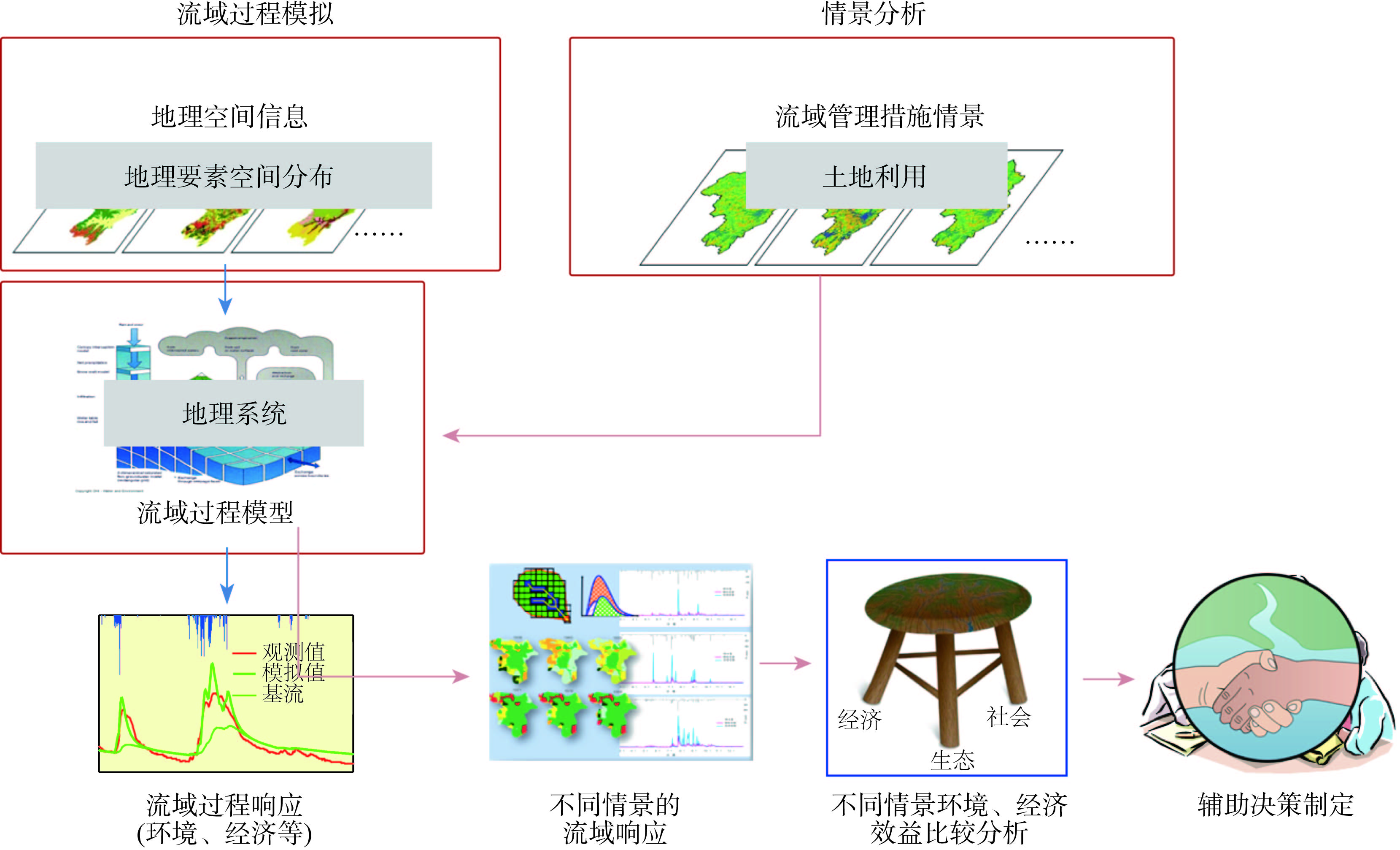
In the context of the changing global environment and rapidly developing economies, the conflict between economic development and resource/environmental conservation is becoming severe. To resolve or relieve the conflict, decision makers need a new knowledge system and scientific decision-making tools. The integrated study of physical geography, which takes the spatial variation and interaction processes of natural geographic elements as main research contents, has the responsibility of providing the new knowledge system and scientific decision-making tools for decision makers. As a relatively closed and independent spatial unit, the watershed provides a natural spatial unit for decision making. The spatial distribution of geographic elements and the mechanism of their interaction processes inside a watershed become the new knowledge system to resolve or relieve this increasingly intensified conflict. Integrated watershed modeling has become an effective way to build this new knowledge system. The effectiveness of different decisions considering the economic and environmental benefits should be evaluated for decision makers before a final decision, which can be provided by a scenario analysis based on integrated watershed modeling. Therefore, from the perspective of resolving or relieving the conflict between economic development and resource/environmental conservation, integrated watershed modeling and scenario analysis is developing into a new paradigm for the integrated study of physical geography in the new era. In this article, the scientific challenges of the integrated study of physical geography based on integrated watershed modeling and scenario analysis were discussed through two case studies of scenario analysis for watershed management, which basically represent two types of questions that decision makers are concerned with. The first type of questions is which kinds of best management practices (BMPs) should be selected, where these BMPs should be allocated, and what economic and environmental benefits are after the implementation of these BMPs. The second type of questions is that under the given objectives of economic and environmental benefits, where the selected BMPs should be allocated and how large spatial extents they should occupy. In conclusion, the integrated study of physical geography based on integrated watershed modeling and scenario analysis should have the characteristics of systematization, spatialization, quantification, ease of use, and decision-making friendly.
Investigating the integrated modeling of water quantity and quality in a watershed has become an important research topic. The integrated modeling of hydrological and biogeochemical processes can quantitatively analyze the change of water cycle and water quality, which is an important means of aquatic environment research and management. By reviewing the development course and recent progress in water quality modeling, we summarized the theoretical methods and corresponding models for catchment-scale non-point source pollution and in-stream (or lake) water quality. The key points in integrated watershed modeling, including model selection, development and integration, and calibration and validation, were discussed in terms of model uncertainty. Finally, we suggested paying more attention to the integrated modeling of natural and human processes in watersheds (including the interaction between human and water environment, hydrological and biogeochemical processes integration) and the application of novel methods (including data assimilation methods, high-performance computation, and artificial intelligence technologies).
Based on the theoretical framework of regional transport geography, watershed transport geography focuses on the research of transport organization and its development using watershed or part of a watershed as research area. This article reviewed pertinent literature of watershed transport geography from three aspects: transport network, transport connection, and regional effect. 1) Related work of transport network mainly focuses on the level and pattern of comprehensive transport development, network connection characteristics and accessibility, as well as the spatial structure and supply chain of the port system. Multimodal transport is becoming a new hotspot in the study of watershed transport geography. 2) Transport connection studies focus on traffic flow and the pattern of connection between passenger and cargo transport. The research focus of watershed logistics geography is shifting from logistics industry layout and enterprise location to logistics network and spatial organization, logistics supply chain. 3) Regional effects are biased towards economic growth effects, with less attention on resource, environmental, and ecological effects. Based on the research focus of watershed transport geography while taking current research progress and basin development needs into consideration, we suggest that watershed transport geography should put emphasis on the development of basin port system and water transport. It is necessary not only to pay close attention to the construction of integrated transport networks, organizations, and multimodal transport, but also to explore the association between watershed transports at different levels of the hierarchy. At the same time, research on the natural resources and environment effects of watershed transport should also be emphasized.
Soil water controls the basic spatial patterns and processes in earth’s surface system. As an important connection and driving force, it regulates a series of hydrological, ecological, climate and geological processes. In this review paper, we first introduced the advantages and disadvantages of different monitoring approaches (direct measurement, geophysical detection and remote sensing) for static soil water processes (soil water content and matric potential); and then introduced the research progress in measuring (runoff plot, tracer and geophysical detection) and modelling (dynamic wave, water balance and hydrodynamic models) dynamics soil water processes (soil water movement). Based on these, we proposed that the future researches should: 1) integrate the soil water monitoring techniques across spatial scales, 2) enhance the investigation in quantification and reduction of uncertainties in soil water modelling, and 3) coupling soil water processes with carbon and nitrogen transport and transformation. This review paper provides the new perspectives for researches and applications in acquiring high spatio-temporal resolution and accurate soil water data, and in revealing the processes and mechanisms and improving the modelling of soil water, carbon and nitrogen cycles.
Spatial differentiation is one of the core research directions of geography. Aquatic ecoregion delineation is the development and application of geographic regionalization in the field of ecological environment. Management based on aquatic ecoregions is the trend of water environmental management in watersheds. Aquatic ecoregion is the foundation of future water environmental management in China. Existing work cannot meet the technical requirements of water quality management for aquatic ecosystem protection. Based on the analysis of the main concepts involved in aquatic ecoregion, this study analyzed the scale of aquatic ecosystem in lake-basins, and laid a theoretical foundation for the delineation of aquatic ecoregion system in lake-basins. Taking the Chao Lake Basin as an example, the method was used to delineate the aquatic ecoregion at four levels, and the results were validated. Aquatic ecoregion delineation of lake-basin is helpful for enriching the study of spatial differentiation of geographical regions, and has important implications for advancing the theory and methods of aquatic ecosystem target management.
Eco-hydrology is a new discipline emerged in the 1990s that studies the hydrological mechanism of ecological processes and structures. It focuses on the hydrological mechanism of ecological patterns and the variation of ecological processes. Lake wetlands are one of the five types of natural wetlands in China. The research on eco-hydrology in lake wetlands is an important branch of ecological hydrology research. It concentrates on the research of coupling features and interactions of hydrology and biological patterns and processes in the multi-temporal scale of wetland ecosystem. In this article we summarized the research progress of eco-hydrology on lake wetlands, including its basic theory, connotation, extension, and main research contents. Following that, we concluded the methodology framework of eco-hydrology. We also identified the current and future research topics in eco-hydrology. Finally, based on some case studies, we demonstrated the responses of vegetation to the variation of eco-hydrological processes in the Poyang Lake. This article may have important guiding significance and practical value not only for water resources protection, ecological biodiversity conservation, and wetland ecosystem sustainability, but also for the improvement of technical support systems of wetland eco-hydrology research and watershed ecology and management.
Since ancient times, humans have lived near water, depending on water for survival and progress. There is a close link between the environmental quality of a lake or river basin and human activity, with the role of their ecological services being of vital importance to local communities. As an advanced technology, satellite remote sensing can monitor the spatial dynamics of the current situation, as well as look back to determine the temporal dynamics of aquatic environments. This allows, when combined with modeling, the possibility to project the future situation in order to improve planning and environmental management. Remote sensing can play an irreplaceable role for humans to understand, monitor, and manage basin environments for the present and future generations. This article focuses on the remote sensing of lake and river basins, exploring different research objectives, addressing the basic theoretical framework, analyzing the state-of-the-art in Chinese and international research programs, and pointing to priorities for future development.
Carbon cycle in karst regions is characterized by a double-layer structure of surface and underground spaces, organic-inorganic coupling, and biological and abiotic process interactions. It is more unique and complex relative to other terrestrial ecosystems. Southwest China is the biggest region of continuous karst landform in the world. The paths and processes of carbon cycle in this region are basically clear based on former research results. However, the carbon flux and transformation mechanisms of the rock, soil, vegetation, atmosphere, and water interfaces are still unclear. It is urgent to perform precision observation of the different components on the scale of small watershed and remote sensing estimation and model simulation on the regional scale. The research progress on observations and simulations of the carbon cycle in Southwest China were summarized in details in this study, and future research emphases were proposed.
Since the 1980s, with demands from water conservancy projects, the rise of canal tourism, and the proposal of the national canal cultural development strategy, the China's Grand Canal has been reviving. At the same time, the size, expansion pattern, and spatial distribution of built-up areas along the Grand Canal have experienced significant changes, with far-reaching effects on city traffic, communication, production, daily life, and public facilities. There have been abundant studies on the key river sections or typical cities. However, there is a general lack of research on the overall expansion of cities along the Grand Canal. In this study, 35 cities along China's Grand Canal were selected as the research subjects. The research area covered two municipalities and six provinces from north to south. Statistical data and remote sensing data were combined in this study for analyzing urban expansion speed, urban expansion pattern, and regional differences of cities along the Grand Canal during 1984-2016. All statistical data were collected from statistical yearbooks. Landsat images were the main data source for urban land mapping. Dispersion index (DI) was applied in this study. The index is a new landscape metric, which was developed for describing the structures and distributions of geographic elements in a region. The results show that: 1) The cities can be classified into four types according to the characteristics of the speed of expansion. Class one contains Shandong, Anhui, Jiangsu, and Zhejiang Provinces, where urban land expansion speed increased dramatically after 2000 and decreased latter. Class two contains Hebei Province and Tianjin Municipality, where urban land expansion speed increased moderately but decreased dramatically latter. Class three contains Beijing, where the highest expansion speed appeared in 2000 and then changed dramatically. Class four contains Henan Province, where expansion speed of urban land changed moderately before and after 2000. 2) Urban built-up areas extracted from remote sensing images are generally larger than urban built-up areas collected from statistical yearbooks. The former is usually between 1-2 times of the latter, and urban expansion in northern China mainly extended around one center, but urban expansions in southern China gradually became polycentric. 3) The spatial distribution of built-up areas in most cities tends to become dispersed and discontinuous, and cities in Jiangsu and Zhejiang Provinces are more remarkable in this respect. The spatial distribution of built-up areas in Beijing was most integrated and compact. The growth of DI values of built-up areas in Hebei Province was the lowest and urban land expansion there was slow. With the successful application for World Heritage of the Grand Canal and the proposal of the Grand Canal cultural development strategy, the construction of the Grand Canal culture belt and the development of canal tourism will become an important measure for promoting the joint development of different regions.
The Yangtze River Economic Belt has been promoted to Chinese national major regional development strategy largely as a natural result of the formation of large river basin economic belt. Large river basin economic belts tend to experience the development process of localized settlements-resources belt (farming and animal husbandry, mining, hydro energy)-traffic belt-industrial belt-dense urban belt, whose spatial development is characterized by growth poles, growth axis, and then economic belt. This change in spatial pattern of large river economic belt reflects the regional development and spatial change of river basin as a basic and unique geographic unit. The spatial change of development from point, axis, to belt also results in a change of scale from small to large, development level from low to high, and spatial spread from point to region of the large river economic belt. The change is not only driven by the advantages of resources and location, but also restrained by the carrying capacity of the ecological environment. It profoundly reflects the importance of geographical environment in the development of economic belts. Taking the development of the Yangtze River Economic Belt as a case, this article discusses the scientific connotation and geographical basis of its formation and change, in order to provide a reference for the development and construction of large river basin economic belts in the new era.
Tourism is a sensitive and vulnerable service industry, and crisis events have become one of the important factors that influence and restrict its sustainable development. Tourism industry is also related to the livelihoods and socioeconomic development of local communities. Therefore it is particularly important to prevent and respond to crisis events and ensure the healthy development of tourism. This research took Jiuzhaigou, Qingchengshan and Beichuan Counties as study area and used 556 survey samples after the Richter 8.0 Wenchuan Earthquake. Based on community participation and community resilience theories and adapting structural equation modeling as a technical method, this study constructed a conceptual framework of community participation based on a crisis response perspective with community participation benefit perception, community resilience, and community attachment as dimensions. The results show that: 1) Post-earthquake community participation benefit perception (0.30, P≤0.001) and community resilience (0.59, P≤0.001) have significant positive effects on local community crisis response and support for tourism development in tourism areas, and the effect of community resilience is stronger than community benefit perception. 2) Community attachment (0.19, P≤0.001) plays a significant positive role in community participation, and has a partial mediating effect on community resilience and community participation intention. However, community attachment has no mediating effect on community participation benefit and community participation intention. 3) This study found that community participation with regard to crisis response is composed of support, involvement, and responsivity. It constructed a community participation "ABR" framework, including community attachment, community benefit, and community resilience. It has expanded the boundaries of research on community participation in tourism areas, and has certain theoretical and practical significance for community participation and crisis management in tourism communities.
In view of the lack of longitudinal, in-depth analyses for tourism seasonality, this study adopted the entropy measuring method, which has not been used by Chinese tourism scholars, and analyzed weekly, monthly, and yearly seasonality based on the daily reception data of the Huangshan Scenic Area for 10 consecutive years. The results are as follows: 1) Entropy redundancy index for measuring weekly, monthly, and yearly seasonality is to some extent superiority due to its simplicity and its combination method has strong policy relevance. The entropy redundancy index calculated by monthly data has the same effect as the Gini coefficient and the seasonal intensity index, and the correlation between them is more than 0.968; in addition, the monthly and weekly entropy redundancy indices calculated by daily data and the combination with other indices can identify seasonal changes in each month and week, and have more micro policy relevance. 2) The entropy decomposition method not only can analyze the seasonal trends of past years, but also can reveal fundamental causes of seasonal fluctuations. According to the entropy decomposition results, seasonal changes in the Huangshan Scenic Area have generally slowed down, and seasonal fluctuations across months and weeks have weakened, but the imbalance within each month and each week has increased. In summary, applying the entropy measurement method to the research of tourism seasonality has greatly improved the theoretical basis and measuring methods of tourism seasonality research, and more importantly, enhanced the policy guidance role of tourism seasonality research.
Understanding the spatial-temporal changes of vegetation and future trends of spatial pattern is of great significance to regional environmental protection and ecological construction. In order to understand the vegetation changes on the Loess Plateau after the implementation of the Grain for Green Project, the spatial-temporal variation characteristics of annual maximum Normalized Difference Vegetation Index (NDVI) (NDVIymax) and growing seasonal mean NDVI (NDVIgsmean) were analyzed based on MOD13A1 data for the Loess Plateau during 2000-2016, supplemented by Sen+Mann-Kendall, coefficient of variation, and Hurst index analysis. The results indicate that: 1) NDVIymax and NDVIgsmean showed a fluctuating growth trend from 2000 to 2016, with growth rates of 0.0070/a (P<0.01) and 0.0063/a (P<0.01), respectively, and the ecological environment improved continuously. 2) NDVIymax and NDVIgsmean showed that the area of vegetation coverage on the Loess Plateau with increasing trend were much higher than that with decreasing trend (93.42% and 96.22% versus 6.58% and 3.78%). This means that vegetation coverage was improving. With regard to the trends of change of the two evaluation indices, the performance of different land cover types slightly differed. The area of forest with most significant increasing trend was 73.02% and 82.60%, followed by cultivated land (47.87% and 67.43%) and bare land (47.03% and 61.68%). The coefficient of variation of NDVIgsmean was smaller than that of NDVIymax, and the stable area was 63.31% and 56.64%, respectively. Of the two evaluation indices, the coefficient of variation of forest was the smallest, representing the best stability. According to the coupling results of NDVI and Hurst index, the areas with increasing trend of NDVIymax account for 41.35%, and the areas with degrading trend account for 58.65% of the total area in the future. The areas with increasing trend of NDVIgsmean account for 49.19%, and the areas with degrading trend account for 50.81% of the total area. The two evaluation indices show that shrubland has the best growth trend. The areas of forest and cultivated land with degrading trend would be greater than 50%. The vegetation status in the areas of unsustainable increase and sustainable degradation need continuous attention of researchers.
Population structure has changed remarkably in rural China along with rapid urbanization and rural-urban migration. Maintaining population quality in source areas of migration is crucial for rural revitalization and sustainable development. By means of the iterative proportional fitting (IPF) algorithm, this study estimated the number of rural population and their years of education in 2000 and 2010 for 2294 counties of China. The spatial pattern and trend of change of rural human resources of the county units in 2000 and 2010 were analyzed based on the quantitative model of human resources. It is found that: 1) Gross human resources decreased by 3.0% in rural areas in China from 2000-2010. Differences between eastern and western regions and variations at the provincial level were the most obvious spatial differences. Spatial agglomeration was significant and more evenly distributed. 2) Human resources per capita had increased by 17.4% in this decade. The outflow of rural human resources had mostly taken place in central China and Northeast provinces. Rural human resources increased in the western region, the Yangtze River Delta, the Pearl River Delta, and prefecture-level cities; the proportion of areas with decreased per capita human resources exceeded 50%. 3) Based on the change of rural gross and per capita human resources, there are four types of county units, that is, the simultaneously increasing type, the simultaneously decreasing type, the increasing quality and decreasing quantity type, and the decreasing quality and increasing quantity type. Change of human resources in counties of hilly areas, plain areas, major grain production areas, and national-level poverty-stricken counties should be paid particular attention to. The proportion of simultaneously decreasing type in hilly counties and plain counties exceeded 40%. The advantage of gross rural human resources in major grain production areas was obvious but the proportion of counties with decreased per capita human resources reached 64.6%. The proportion of simultaneously increasing type in national-level poverty-stricken counties was 43.9%, but there remained a gap with other counties. Based on the results, the priority for sustainable development of rural areas is to prevent the decrease of human resources of hilly counties, plain counties, and major grain production areas, and to improve the gross human resource level in poverty-stricken counties.