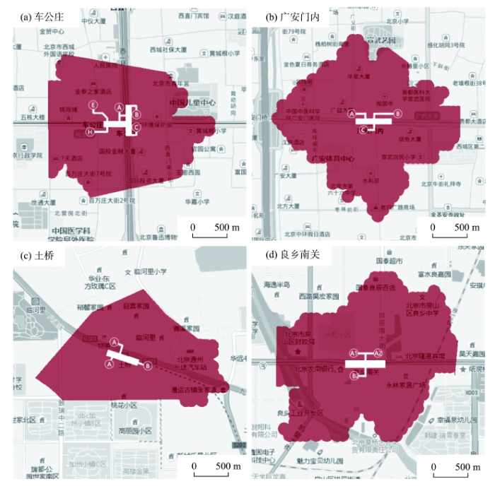
The development of urban rail transit (URT) network improves the commuting efficiency of residents while it has a certain impact on their jobs-housing balance. This study took 206 URT stations in Beijing as an example and classified them according to their jobs-housing functions based on the Gaussian mixture model (GMM) and smart card data. The dynamic population distribution characteristics around URT station were explored and jobs-housing ratio was calculated by "Yichuxing" position data. The study found that: 1) The jobs-housing balance in the central city is obviously better than that outside of the central city. 2) At the ends of the URT network, the jobs-housing balance is worse while only a few stations with concentrated distribution of top service industries have formed regional employment centers. 3) There still exists a certain degree of jobs-housing mismatch in the areas around some suburban stations where employment and residential functions are relatively equal. Station outflow-inflow and jobs-housing balances were calculated by the station egrass-ingrass ratio and the jobs-housing ratio, and the correlation between URT commuting behavior and jobs-housing balance was analyzed by generalized autoregressive conditional heteroskedasticity (GARCH) model. The results of this study indicate that: 1) There is a very strong positive relationship between URT station egrass-ingrass balance and jobs-housing balance. The closer the numbers of URT station outflow and inflow population, the better the jobs-housing balance around the URT station is. 2) There is a strong positive relationship between employment opportunity and jobs-housing balance around a URT station; and there is a strong negative relationship between residential function and jobs-housing balance around a URT station. This suggests that dense settlement will not generate the same quantity of jobs while well-developed employment hubs can attract a certain number of residents to live nearby. 3) There is a positive correlation between locational conditions of URT stations and jobs-housing balance. 4) The GMM can effectively cluster URT stations with complex and unclear attributes. 5) With its advantages of real-time data capturing, high precision, wide coverage, and great accessibility, "Yichuxing" position data can effectively compensate for the limitations of other methods on collecting and analyzing spatial-temporal characteristics of real-time population distribution at the microscopic scale.
Walking is not only an important and convenient travel mode but also a primary component of physical activities. However, in the modern era that is characterized by fast pace of living, urban people, especially those facing relatively intense time constraints such as office workers and students, tend to walk increasingly less. This has led to a reduced level of physical activity and partially resulted in widespread prevalence of non-communicable diseases (NCDs) such as obesity and diabetes. There have been many studies in the Western contexts confirming the significant impacts of the built environment (usually depicted by the 3D or 5D model) on walking. However, existing research is incomplete in the following two aspects: on the one hand, the current conclusions have been mainly based on the Western contexts, and therefore their applicability in cities of rapidly developing countries such as China is understudied. On the other hand, different population subgroups—for example, office workers and students—are featured with different lifestyles and habits. Thus, a research question arises: does the built environment affect their walking behavior in the same manner with regard to direction and magnitude? To address the aforementioned research gaps, this study examined and compared the impacts of the built environment on office workers' and students' pedestrian commuting in Hong Kong. Multivariate linear regression models and spatial econometric models were employed based on the 2011 Hong Kong Census data, Hong Kong Tertiary Planning Units (TPU) data, Open Street Map data, and CentaMap data. We found that: 1) Commuting distance is the strongest determinant of office workers' or students' probability of walking to workplaces or schools. 2) The associations between the built environment in Hong Kong (delineated by the 5D model, namely, density, diversity, design, destination accessibility, and distance to transit) and pedestrian commuting behavior of office workers and students are different from those in the Western contexts. For example, distance to transit is widely confirmed to significantly impact people's walking in Western countries. However, the variable is insignificantly associated with workers' or students' propensity of pedestrian commuting in Hong Kong. 3) There are apparent differences between the effects of the built environment on pedestrian commuting propensity of office workers and students. For example, population density is associated with office workers' and students' propensity of pedestrian commuting negatively and positively, respectively. This study highlights the importance of contexts and population differentiation in the built environment-travel behavior association research. Geographers, urban planners, public policy practitioners, and policymakers can draw on the findings of this study to make more informed and targeted interventions to mitigate physical inactivity for certain population groups. Further study can pay more attention to 1) impacts of the built environment surrounding a workplace/school and/or those of routes from home to workplace/school on pedestrian commuting behavior; and 2) the increasing differences between the built environment of Hong Kong and cities in the mainland of China and the underlying mechanisms of variation.
Under the background of rapid suburbanization, suburban areas have become the most changeable and complex region in metropolitan areas. Increasing the dependence of residents' daily activities on neighborhood space is of great importance for relieving the pressure of urban development and improving the quality of life of residents. Studies show that residents' psychological dependence on a neighborhood also has a positive impact on life satisfaction. Based on the concept of people-oriented development, Shanghai City Master Plan 2017-2035 proposes to build 15-minute life circles, and to optimize the spatial structure of suburbs. In the context of rapid suburbanization and community life circle construction, this research built a framework that combines the two dimensions of functional attachment and emotional attachment to study neighborhood attachment of residents in Shanghai suburbs. It aimed to answer the following research questions: 1) How is residents' neighborhood attachment from a comprehensive perspective that combines the two dimensions of functional attachment and emotional attachment? 2) What are the differences of neighborhood attachment among various social groups? 3) How do the built environment and the subjective perception of neighborhood environments impact individuals' neighborhood attachment? The data used in this research came from an activity-travel behavior survey conducted in Shanghai suburbs in 2017. The data include individuals' socioeconomic attributes, daily activities, and perception of communities. First, this study analyzed the characteristics of residents' neighborhood attachment and the differences of different social groups. Second, on the basis of the research framework, residents' neighborhood attachment was divided into four types: neighborhood attachment, neighborhood dependence, neighborhood identity, and neighborhood exclusion. Multiple Logistics regression models were used to analyze the impacts of the built environment and subjective perception of neighborhood on individuals' neighborhood attachment type after socioeconomic attributes were controlled for. Third, based on the results of regression analyses, we represent the relationships between socioeconomic attributes and neighborhood attachment, and neighborhood characteristics and neighborhood attachment by two coordinate systems. The differences of neighborhood attachment among different social groups are significant. Neighborhood characteristics have significant influences on neighborhood attachment: the density of neighborhood facilities mainly influences functional attachment; neighborhood green space ratio influences both functional attachment and emotional attachment; residents' subjective evaluation of neighborhood environment mainly influences emotional attachment. According to the research findings, the construction of community life circle should maintain and improve environment quality and focus on the arrangement of green space, open space, and leisure facilities. Meanwhile, it is important to promote the social integration of residents in the neighborhoods.
During China's rural industrialization, land in villages and towns has been rapidly transformed into non-agricultural use. The Pearl River Delta in South China is the most representative of China's rural industrialization and urbanization. In the Pearl River Delta, the cities of Dongguan, Zhongshan, and Foshan are typical cases of both rural industrialization and land-use change. The dataset used in this study includes the land-use data of 2015 in Guangdong Province and the land-use data of the three cities between 2009 and 2015. This dataset provides valuable information on the post-2010 spatial structure of villages and towns in the Pearl River Delta. Based on this dataset, we examined the current (around the mid-2010s) spatial conditions of villages and towns in the Pearl River Delta. We first analyzed the spatial attributes of construction land. The analysis was based on eight indices or methods: land patch density index, spatial discrete index, spatial uniformity index, the mean of land patch area, fractal dimension index, landscape fragmentation index, buffer analysis, and Moran's I analysis. Then, we analyzed the spatial distribution relations between industrial and non-industrial land uses, and between construction land and transportation land through a statistical analysis. Finally, we discussed the industrial factors of the detected spatial pattern through the gray associative analysis. Our findings indicate a high fragmentation and even distribution pattern of village and town built-up areas in Dongguan, agglomerated and discrete pattern in Foshan, and medium level fragmentation and discreteness in Zhongshan. Diverse industrial development in the three cities had a major impact on the formation of the spatial patterns. In the future, the transformation of the spatial pattern of built-up areas in villages and towns in the Pearl River Delta must coordinate with the industrial development and the ongoing development of the Guangdong-Hong Kong-Macau Great Bay Area. Approaches to facilitating the transformation include the modification of the industrial structure and an adjustment of land use and transportation across these villages and towns. This article aimed to reveal the current spatial patterns of crucial rural-to-urban transformation in a rapidly urbanizing region and to provide relevant policy recommendations. The results may contribute to our understanding of China's continuous rural urbanization and industrialization.
Identification of urban agglomeration boundary is the key to the smart and compact development of urban agglomerations. It also contributes to the development of national spatial governance system and the ability of spatial governance. Taking the Beijing-Tianjin-Hebei, Yangtze River Delta, and Pearl River Delta urban agglomerations as an example and by combining the Suomi National Polar-orbiting Partnership / Visible Infrared Imaging Radiometer Suite (NPP /VIIRS) night light images and points of interest (POI) data, this study aimed to accurately identify the actual physical boundaries of the three urban agglomerations and to analyze the spatial features of the agglomeration space by density-based curve threshold method and object-oriented fractal network evolution algorithm. The results show that: 1) The curve threshold method based on POI density and the NPP/VIIRS fractal network evolution algorithm both recognize that the boundaries of urban agglomeration are smaller than the administrative boundaries of the national urban agglomeration planning, and the identified ranges are 20.90%-24.40% of the planned ranges. 2) The areas of urban agglomeration extracted by POI and night light data are very close and can be compared and verified with each other. The areas of urban agglomerations extracted by POI data are larger, which to a great extent reflect the overall boundary of urban agglomeration instead of internal details. The urban agglomeration areas extracted by NPP/VIIRS images are more fragmented, which can identify the core areas of urban agglomerations. 3) Overlay of urban agglomerations extracted from the POI and the light data shows that in addition to the core zones, there are many isolated point areas in the three urban agglomerations, indicating that the three major urban agglomerations in China are still at a rapid development stage. The intensity of inter-city contact needs to be further strengthened.
The underlying causes of aggravating urban environmental pollution, escalating energy consumption, population overcrowding, and other urban environmental problems are imbalances in urban metabolism. In order to accurately predict the trend of urban metabolism changes in Beijing City, the exosomatic metabolic rate of Beijing from 1980 to 2016 was estimated by the indicators of energy consumption and human activity time, and the degree of urban metabolism was characterized. Based on the results, the long short-term memory (LSTM) neural network model was used to predict the exosomatic metabolic rate of various sectors in Beijing from 2017 to 2022. The results show that: 1) the urban metabolic prediction model based on LSTM neural network has high accuracy and can make more accurate prediction on the exosomatic metabolic rate of various sectors in Beijing. 2) From 2017 to 2022, the exosomatic metabolic rate of the primary industry and the overall external energy in Beijing show a downward trend, among which the primary industry reached its peak in 2017, and the exosomatic metabolism rates of the secondary and tertiary industries show an increasing trend. 3) Except for the primary industry, tertiary industry and the overall exosomatic metabolic rate, the temporal perturbation of historical change ranged from small to large. 4) The factors that contribute the most to EMRT are EMR2, and the least are EMR1. This study may provide a theoretical basis and decision-making support for policymakers to optimize urban management plans and enhance urban comprehensive strength.
The innovation of agricultural industrial clusters is a process of integration of various relationships, while the development of modern agricultural clusters cannot be separated from the local and global contexts. Hence, it is of great theoretical and practical significance to study the innovation of agricultural clusters and its spillover effects with regard to the local and global network relationships. Taking the Shouguang Vegetable Production Industrial Cluster as an example and using field survey data obtained in 2017, and social network analysis and a spatial econometric model, this study analyzed the pathways and spillover effects of cluster innovation. The results show that: 1) The cluster's local connections include a strong local enterprise network and a weak government-industry-university-research network, in which the agglomeration of the local enterprises is prominent, and the enterprises are closely linked. The core enterprises in the two relationship networks have a strong control over resource and information. 2) As a weak link outside the cluster, the global network has a low density of network links. The network as a whole shows the characteristics of structural holes, and its core node enterprises show strong control over overseas resource heterogeneity. The spatial error model is better than other models in measuring the spillover effects of cluster innovation, in which the cluster's local enterprise relationship, inter-enterprise spatial proximity, and global relationship all play a certain role in promoting cluster innovation. Further mechanism analysis shows that local relationship links and global relationships play different roles in cluster innovation, and the interaction between strong and weak relationships is the key to the diffusion, absorption, and utilization of heterogeneous innovation resources.
Characterizing the regional intensity of human activities is an important scientific issue. In this study, the pole-axis spatial system (central places and roads of multiple grades, such as city, county, farm, and village and railway, highway, national road, provincial road, municipal road, county road, and town road) and central place theory were adopted to represent the spatial agglomeration characteristics of regional human activities as direct risk source of wetlands. Soil erosion and non-point source (NPS) pollution indicating indirect effects of human activities on wetlands at the regional scale were also considered. Based on these results, the regional ecological risk assessment (RERA) framework of wetlands was established. Using this wetland RERA framework, the spatial heterogeneity of risk grades in the Sanjiang Plain area was analyzed. The results show that: 1) The Defense Meteorological Program Operational Line-Scan System (DMSP/OLS) nighttime light intensity data and multiple level roads data could be used to delineate the regional "pole-axis" system and characterize the direct risk source of wetlands stemming from human activities at the regional scale. High and very high risk source intensity areas matched well with the regional pole-axis system, especially with the central places and roads of high grades. 2) Owing to its high ecological capital value per unit area and vulnerability, wetlands had highest risk. 3) The low, medium, high, and very high risk areas accounted for 64.00%, 24.28%, 10.38%, and 1.34% of the study area, respectively. 4) Overall, the southern parts of the Sanjiang Plain had higher risk levels than the northern parts. With regard to the management of regional ecological risk of wetlands, our recommendations include emphasizing the spatial relationship (location, direction, and so on) between wetlands and the regional pole-axis system in order to control direct risks of wetlands from human activities, and tradeoff and synergy between wetlands and other ecosystems (rainfed cropland, rice field, and forest land) through prevention and control of soil erosion and NPS pollution stemming from non-wetland areas in order to reduce the risk level of wetlands at the regional scale.
Reconstruction of cropland change over the past 300 years forms the basis for environmental change studies. The influence of changes in river and lake areas in North China can provide a reference and validation for the reconstruction of historical arable land. Based on the local historical documents of the Qing Dynasty, the statistical data of the Republic of China, and the data of modern land use, this study reconstructed the cropland change of five time periods in the Baiyangdian Lake and the southern area of the Daqing River Basin in the past 300 years. It established the reclamation model by quantifying the slope and the potential cultivated land reclamation rate in historical periods. The spatial resolution of the analysis is 1 km × 1 km. This study also analysed the influence of river and lake evolution on the cultivation ratio via the changes of the Baiyangdian Lake and the southern branches of the Daqing River. The results show that: 1) Land reclaimation in the research area has expanded to the mountainous areas, and reclamation has constantly intensified over the past 300 years. Average cultivation ratio increased from 0.162 in 1646 to 0.579 in the 1980s. 2) The contraction of the Baiyangdian Lake provided a good material basis for land reclamation in Anxing, Rongcheng, Renqiu, Gaoyang, and Lixian Counties. The reclamation rate of the five counties in the middle and late Qing period was about 3%-40% higher than that of the surrounding counties, and the growth rate was faster too than that of the surrounding counties. 3) The old river channel provided material basis for land reclaimation of Suning, Hejian, Renqiu, and Anguo Counties. After the river diversion, the reclamation rates of the former three counties increased by 2.12, 2.6, and 2.86 times respectively. The reclamation rate in Anguo County increased by 37%, the most significant increase in the same period. 4) Although the new river could destroy some of the land, the floodplain, however, can provide a material basis for land reclamation. Therefore the cultivation ratio of the counties along the new river can increase or decrease. The reclamation rates of Lixian and Gaoyang have increased to 1.80 times and 1.88 times respectively. The reclamation rate of Wangdu and Qingyuan increased by 3% and 4%, and that of Dingzhou decreased by 4%.
Driven by the social process of modernization and urbanization, place identity is undergoing transition and iteration. Different from other sectional studies of place identity from a static perspective, the authors adopted a dynamic perspective based on the life-course theory and mobility of home. The authors selected an individual and his family with a life span of 70 years as the research subject, tracked the change of their place identity with migration and through time, and analyzed its social meaning with a life-history approach. The conclusion is that, place identity undergoes dynamic changes, including transition and iteration during spatiotemporal transition and life experience accumulation, in the process of rural-urban migration of the earliest Guangzhou migrants, Mr. Y and his family (the individual-family subject). This dynamic change connects tightly with the mobility of home. While migrating, the individual and his family members produced place resistance and place thrust, which combined and resulted in the iteration of place identity. Social environment and social scenes, family roles, cultural adaptation, and individual behavior adjustments are important factors influencing place identity iteration in the process of urbanization. This case study also found that, the changes of family types and generation gap could affect the extent to which place identity iteration occur. Therefore: 1) Place identity is not a static sense of place. It will dynamically transform and iterate with the change of time and space and the layering of life experience. 2) The individual-family life course is an important dimension to elaborate and interpret the local economic and social development. The flow of the family is the basis for uncovering the iterative process of place identity. Because the flow of the family connects different places, the life and personality of the family members brand different localities in the process of flow, and then place identity changes dynamically. 3) Different macro geographic conditions are the binding conditions for the iterative change of individual-family place identity. The more places experienced by individual-family, the more likely that the place identity has an iterative process.
Vestige of the Quaternary glaciation is well preserved in the middle Tenasserim Chain located in the west of the Hengduan Mountains. In this study, we investigated Quaternary glacial deposits in this area using the methods of luminescence dating, grain size, magnetic susceptibility, and mineral and chemical elements analyses, discussing the characteristics of sedimentology, mineralogy, environmental magnetism, and element geochemistry aspects of Quaternary glacial deposits during different periods in the study area. We also combined the related environmental indicators to analyze the environmental characteristics of this area. The results display that: 1) The overall sedimentary characteristics of glacial sediments are mixed size, no bedding, no sorting, and the degree of weathering weakened from the MIS6 to the MIS1. 2) Fine particles of glacial deposits in the study area show bimodal and multimodal spectra in frequency curves, which reflects that glacial deposits have complex sources. The average grain size of moraines shows that the farther away from the source of glaciation, the smaller the grain size-it was mainly affected by the intensity of glaciation and the duration of weathering. 3) The magnetic susceptibility of glacial deposits in the study area ranges from 8.72×10⁻⁸ m3·kg-1 to 298.00×10⁻⁸ m3·kg-1. The average value (178.51×10⁻⁸ m3·kg-1) and amplitude of fluctuation (17.43×10⁻⁸ -298.00×10⁻⁸ m3·kg-1) of the magnetic susceptibility of ice water deposits are greater than moraines (average value: 19.82×10⁻⁸ m3·kg-1, amplitude of fluctuation: 8.72×10⁻⁸-42.95×10⁻⁸ m3·kg-1), which reflects that the grain size of centralized distribution of magnetite is similar to the grain size of ice water deposits. 4) The analysis of geochemical indicators of elements and minerals show that the overall characteristics of the paleoclimate in the Qinggulong area was cold and dry; the climate was the driest during the MIS2, but precipitation of the MIS3b was higher. The precipitation of MIS6 was more than the MIS2 and MIS3b, but the temperature was lower.
In empirical studies the application of tourism life cycle theory is questioned because of the different modes of study sites and difficulty in dividing life cycle stages. This study selected 14 national historic site parks in the United States as an example. The four-parameter Logistic model, which is rarely used in tourism research, was combined with the primary function, the quadratic function, the cubic function, and the Gaussian multi-peak analysis methods to fit the life cycle of the tourist destinations. The study found that the four-parameter Logistic model combined with the primary function, the quadratic function, and the cubic function can better fit the life cycle of these tourist destinations; the four-parameter Logistic curve can be used to quantitatively divide the tourism life cycle by the upper bend point, the inflection point, and the lower bend point into initial exploration, development, consolidation, and stagnation stages, and the primary function, the quadratic function, and the cubic function can fit the recession or rejuvenation stage of the tourist destinations, which addresses the concerns of scholars that it is difficult to quantitatively divide the life cycle stages. Based on the development trend after the stagnation period of tourist destinations, the life cycle type of the tourism destinations can be identified. The Gaussian multi-peak analysis method fits the life cycle of the tourism destinations into a volatility Gaussian peak, which retains tourism change to a greater extent. The characteristics of fluctuation in the life cycle of tourist destinations completely answer the questions of scholars about the life cycle model's application in tourism research.
Based on the definition of "public opinion," "political public opinion," and "political public opinion forces" and taking discourse power and geopolitical imagination of critical geopolitics as methodology, this study mainly analyzed the formation and impacts of "political public opinion forces" in the political changes of countries in the Middle East and North Africa region from 2010 to 2015. The research results show that the "political public opinion forces" formed against a profound domestic background in the countries of the Middle East and North Africa as well as the international context. Their formation experienced the following process: beginning with the appearance of public opinion events, then moving on to the gathering of people and the rise to political issues, and ending with the domestic and foreign forces finding agents and forming the political powers to incite, protest, and push forward the political changes. After the formation of "political public opinion forces" and under the tactics of various actors, the "political public opinion incidents" expanded at home and aboard while it spread spatially from south and north in herringbone trajectory. As the pivotal actor among the various actors, "political public opinion forces" on the one hand caused the successive political changes of related countries in the Middle East and North Africa. It on the other hand further promoted the differentiating and restructuring of regional geopolitical relations. This is a meaningful attempt to interpret and analyze public opinion events with geopolitical theory.
The establishment of strategic partnership between China and Russia is an important measure for jointly contributing to the sustainability of social and economic development in both countries. Improving the understanding of the development of geography in China and Russia and further expanding the scope of cooperation are necessary for such development. Based on the literature on Russian socioeconomic geography and annual conference material of the Association of Russian Geographers in the past decades, this article briefly expounds contemporary progress of related work in Russia with the vision of inheritance and innovation. The development and major trends of the socioeconomic geography thoughts in Russia are discussed. On the basis of dividing the transformation of Russian economic geography into six stages, this article focuses on terms and phenomena of changes in national or regional geo-relationships, multi-scale regional spatial organization, the development of regional economic network structure, the construction of "big Europe and Asia", as well as the conception of "eastward development". We mainly discussed the inclusivity of socioeconomic geography, as well as the emergence of new sub-disciplines, new ideas, and new concepts along with the progress of globalization and national development. We thereafter listed major concerns of socioeconomic geographers in Russia, as well as the leading scholars and their masterpieces. We also pointed out the shortcomings in the areas of theory and methodology construction, development of less-developed regions, social equity, and poverty, among others. This study may have potential in deepening mutual understanding between Chinese and Russian geographers and promoting the innovative development of socioeconomic geography.