

农业地理学既是地理科学的重要分支,也是农业科学的组成部分,其研究对象是农业经济活动地域体系的形成过程、结构特征和发展规律,并为农业区域规划布局和农业资源可持续利用提供支撑。农业地理学思想在中国古已有之,传统农耕生产实践过程中孕育了早期农业地理学思想。近代农业地理学渐成科学体系,旨在研究解决区域农业发展问题[1]。1949年之后,国家明确提出把实现农业现代化作为“四化”任务之一,而农业地理学研究与经济建设的结合也愈发紧密,在农业生产指导与农业发展决策等诸多领域发挥着越来越显著的作用。尽管农业地理学研究几经曲折,但伴随着改革开放的大势,农业综合生产能力不断增强,农业地理学研究亦走向繁荣。进入21世纪,伴随着工业化和城镇化的不断发展,农业农村发展问题日益突出,农业生产和乡村发展亟需转型升级。各级行政部门和地理同行们对农业农村问题日益重视,党的二十大报告中提出要建设现代化农业产业体系,全面推进乡村振兴,农业现代化、农业深度融合、农业农村优先发展、农业强国等战略主题受到广泛关注,新时代农业地理学研究仍具有广泛的社会需求。
农业农村发展的新局面、新问题促使农业地理学研究需不断拓宽研究领域,深化研究层次,强化研究方法,与相关学科共同推进交叉与综合研究。当前,农业地理学研究内容主要聚焦于4个方面:一是农业生产与社会经济的关系,主要研究农业现代化发展治理路径、农业产业结构转型升级、农业经济发展政策的导向等;二是农业资源的可持续利用,主要研究如何协调农业资源的可持续利用与发展的关系,耕地资源的保护与可持续利用、农业生态效率和国家粮食安全等;三是农业生产生活空间的布局,主要研究不同农业地域区划类型、统筹城乡融合发展、农村人居环境、地区农业地理志等;四是农业与乡村地理综合研究,主要研究农业的多元化发展、乡村系统的演化、农业可持续发展和农业强国的协同推进等。这些内容既传承了中国古代传统农业地理的思想,也借鉴了西方发达国家农业地理学的理论和实践方法,其研究内容逐渐丰富和深入,可服务于国民经济社会的发展。梳理百年来中国农业地理学的研究进程,总结其发展取得的成就和经验,对于继续推动中国农业地理学的发展具有较高的理论和实践价值。
1 中国农业地理学研究发展进程
表1 中国农业地理学研究主题变化
Tab.1
| 时段 | 时期 | 宏观背景 | 农业地理学主要研究主题 |
|---|---|---|---|
| 1949年之前 | 历史记述时期 | ●生产力低下 ●阶级社会 ●农为国本 ●西学东渐 | ◆农业区划 ◆农作布局 ◆农业状况调查 ◆农作条件与农业物产 …… |
| 1949—1976年 | 农业集体化时期 | ●生产力不发达 ●计划经济体制 ●“以粮为纲” | ◆农业区划 ◆农业生产布局规划 ◆农业生产相关要素发展 ◆农业生产结构整治与改良 …… |
| 1977—2003年 | 改革发展时期 | ●农村经济体制改革 ●社会主义市场经济体制 ●城乡巨变 | ◆农业布局与结构调整 ◆农村劳动力结构变化 ◆农业生产基地建设 ◆农业产业化 …… |
| 2003年以来 | 现代变革时期 | ●WTO时代 ●可持续发展理念 ●人民向往美好生活 ●发展不平衡不充分 | ◆农业转型升级 ◆农业现代化 ◆农业地理集聚 ◆生态农业 ◆农业可持续发展 ◆农业生产与乡村振兴 …… |
图1

图1
中国农业地理学典型研究成果时间轴线图
Fig.1
Tiypical research results of Chinese agricultural geography
在历史记述时期,经历了奴隶社会、封建社会、半殖民地半封建社会,农业生产力水平一直较为低下,国家阶级统治的维系高度依赖于农业生产,故从上至下一直重视农业发展,而自中国步入近代以来,西学东渐之势日盛,为中国传统的农业生产与农业地理学研究创造了机会。受宏观背景影响,历史记述时期虽在农业地理思想上有发展,但基本停留在对农业地理的记述上,研究主题主要表现在农业区划、农作物布局、农业状况调查、农作条件改善与农业物产调查归纳等,并未形成中国农业地理的理论系统。
在中国农业集体化时期,受社会生产力条件约束与高度计划经济体制影响,农业生产紧抓“以粮为纲”的方针。该时期农业地理学的研究主题受到计划经济体制的影响,一些学者把社会主义农业发展的学术思想融入农业地理学的研究中,农业区划、农业生产布局规划、农业生产相关要素和结构的整治与改良等受到关注,例如中低产田的改良、盐碱地整治、排灌系统构建、黄土高原土壤保持[2]等。
改革开放使传统的计划经济体制开始松动,农村经济体制改革和社会主义市场经济体制逐渐确立,城乡关系也逐步演化,国内农业农村环境也因之而变[3]。为了适应新的市场经济形势的变化,农业生产布局与规划也随之调整。这一时期在改革开放和发展中国特色社会主义市场经济的大背景下,农业地理学研究思想越来越开放,并进入稳定发展期,产出成果较多,其主题主要表现为农业生产布局与结构调整、农村劳动力结构变化、农业商品生产基地建设、农业产业化等。
2 中国农业地理学研究阶段划分
2.1 历史记述时期的农业地理学研究
中国自古以来就是一个农业大国,为了维持巨量人口的生存,重农、兴农、劝农的思想早在夏商周时期就得到了统治者与普通人民的一致认可。农业生产因地制宜、合理布局的原则是中国古代农业地理学思想的核心[7]。春秋战国时期的《左传》、西汉时期的《礼记》中都有关于合理布局农业生产,利用季节变化、地域优势、农业自然资源、土地资源来发展农业生产的记载[8]。而同一时期的《尚书·禹贡》则萌生了区域农业地理学的思想,将“天下”划分为九州,并且评述了各地的农业生产条件与现状,堪称最早的农业区划研究[8]。西汉时期《淮南子》中记载了利用垂直地带性因素和水域、沃土来发展农业生产以应对饥馑[8]。明清时期外来高产粮食作物引入,改变了以往的农业生产耕作制度,提高了农业生产力,并催生了农业区域分工[9]。
自近代以来西学东渐,中国传统的农业地理学研究受到了西方研究方法的影响,并扎根本土,结合国家农业发展实践而开始近现代的农业地理学研究。在20世纪初,地理学者们开展了一系列中国农业状况调查,自1916年始,在清华科学社的支持下,李济[10]、郑步青[11]、沈有乾[12]等撰写了多份中国农业状况调查报告,从区域气候、土壤、水利、肥料、农产品等10余个方面入手,对北京、福建、江苏等地的农业地理学着重进行调查总结。1931年由商务印书馆发行的《农业地理》是较早系统介绍农业地理学研究内容的专著[13]。1932年张心一[14]所著的《中国农业概况估计》是中国最早的成套农业地图。1933年翁文灏[15]发表的《中国人口分布与土地利用》是早期的土地利用研究。1934年胡焕庸[16]发表的《江苏省之农产区域》将江苏省划分为四大农业区,这是中国最早的、具有近代科学意义的农业区划研究。后续又开展了安徽[17]、山西[18]等省的农业农产区划工作。1935年胡焕庸[19]测算了当时江宁县的耕地与人口密度,并绘制江宁县的山圩田分布图与比例图,制作该县人口分布、密度、外移比例图等。1936年,地理学者把农业区域研究扩大至全国,从气候、地形、耕地、物种、人口等方面论述各省各地区的农业条件与农业物产[20]。1937年出版的《中国土地利用》是最早的且较为系统的对全国土地利用所进行的研究[21]。在民国期间,农业地理学研究体系逐渐完善,研究领域与深度不断拓展,新式研究方法得到应用,为中国现代农业地理学研究奠定了基础。
2.2 农业集体化时期的农业地理学研究
中国农业集体化时期大致对应的是从20世纪40年代末到70年代中这一段时期。一方面为了支持国家的农业生产宏观计划和资源的配置,一方面为了解决温饱不足的困境,农业地理学坚持为农业生产服务,农业地理学发展较为稳定,主要以农业区划和农业地理综合研究为主。
2.2.1 农业区划研究
农业区划研究成果是农业生产合理分布和国家农业发展计划的主要依据[22]。50年代早期,全国农业分区问题亟需解决,农业地理学家着手开展农业区划工作,初步制定了国家农业区划方案,提出中国农业地带和农业经济区的方案。此外,还综合了24个省级区划成果,印制了《全国各省区市农业区划资料汇编》。1955年,周立三等[23]对甘青农牧交错地带的农业区划进行了调研,赵松乔[24]也分别在1956年和1959年对内蒙古和西南地区的农牧交错地带进行了农业区划方面的研究,在这个过程中出现了中国的作物区划和部门农业区划。由邓静中[25]编撰的《中国农业区划方法论研究》一书于1960年出版,书中较为系统地阐述了中国农业区划的概念、任务、原则和种类,并评述了国内外农业区划的经验借鉴。1963—1966年是中国农业区划的高潮发展期,农业自然资源调查与农业区划获得广泛开展,同时也开始尝试进行农业自然条件的单要素区划。
2.2.2 农业地理学综合研究
1949年后相关部门组织地理学专家、学者陆续对新疆、西藏、内蒙古、宁夏、黑龙江、黄土高原、华南、川滇等地进行了一系列的地理综合考察,并着重在农业自然资源条件评价、农业生产布局与初步分区、土地利用、农业部门地理和农业地域类型等方面开展研究,撰写了一批考察报告,编制了相应的图件。在农业地理学专著编写方面产出较多研究成果,中国科学院地理研究所组织编写了《中国农业地理丛书》,包括《中国农业地理总论》与各省农业地理分论,该套丛书编写规模浩大,是全面论述中国农业发展特点和区域分布规律的开山之作[26],丛书在20世纪80年代初陆续出版。
2.3 改革发展时期的农业地理学研究
改革开放使传统农业和农村生产情况发生剧烈变化,农业地理学在原有研究基础上得到了进一步深化,同时开拓了新的研究领域。本文将此期间的农业地理学研究细分为两个阶段,分别是改革阶段(1977—1990年)和加速阶段(1990—2003年)。
2.3.1 改革阶段(1977—1990年)
(3) 在农业土地利用研究方面。土地利用是农业活动地域差异及演变的直观反映,也是农业地理学研究的重要内容。吴传钧[32]主持了“全国1:100万土地利用图”的国家重点研究课题,同时编制了《中国1∶100万土地利用图》,这是世界上第一部全国规模的小比例尺土地利用地图集。该图集是中国土地利用研究的一项重大进展,较好地推动了中国农业发展规划和布局,对国内外土地利用研究与制图方面都有着重要意义。
(4) 在农业生产布局和农业类型研究方面。开展了包括粮食作物布局研究、经济作物布局研究、热带亚热带作物布局研究、畜牧业生产布局研究和水域利用与渔业发展的农业生产力布局研究。从自然、经济、生态等方面探索农业生产空间规律,提出优化农业布局的方案。在这一时期,除种粮以外的其他农业经营形式得到较快发展,畜牧业和渔业也受到关注。在农业类型研究方面,进行了全国农业类型划分的系统研究[33],有利于解释农业生产地域规律,推动一定区域内农业生产的专业化和产业组织化。
2.3.2 加速阶段(1990—2003年)
1990—2003年,农业地理学研究主要集中在农业结构调整与产业化、农业资源可持续利用、区域农业可持续发展战略、农业与乡村地理综合研究等方面。
(2) 在农业自然资源可持续利用方面。这一时期的研究主要围绕土地资源和水资源来开展。1994年出版了由孙颔[37]编著的《中国农业自然资源与区域发展》一书,该书在农业资源可持续利用和农业可持续发展等方面取得了研究新进展。贾绍凤等人探讨了当时中国耕地数量下降的原因,预测未来耕地变化趋势,提出了节约土地资源的对策[38]。徐勇[39]在分析筛选农业资源的农业生产行为特点和高效利用方式的基础上,构建了农业资源高效利用评价指标体系。李宪文等[40]、罗明等[41]对耕地保护规划、土地评价与土地规划、土地整理的区域差异等展开探讨。由孙颔、石玉林[42]主编的《中国农业土地利用》一书,是农业资源可持续利用视角下中国农地利用研究的代表作。
2.4 现代变革时期的农业地理学研究
本文把2003年以来定义为农业地理学研究的新时期,2003年中国全面取消农业税,在中国农业发展历程中具有划时代的意义。政府加大对“三农”的投入,“国”与“农”之间的关系开始了“由取到予”的转变,为城乡进入统筹发展轨道做铺垫。与此同时,科学发展观战略思想被提出,这要求中国农业进一步走可持续发展道路。自2003年以来,中国农业地理学研究主要集中在农业资源可持续利用、区域农业可持续发展、农业转型升级、农业与乡村地理综合研究等方面。
2.4.1 农业资源可持续利用
这一时期的研究主要从土地资源和农户两个角度来展开。从土地资源利用来看,提出了中国耕地转型和土地整理的研究框架[53],构建耕地质量评价指标体系,对耕地质量保护进行指导[54],从耕地数量、质量、生态三方面分析中国耕地资源的安全状况,评价各省耕地资源安全度,揭示耕地资源安全值的区域分布格局并探讨其形成机理[55]。从粮食安全视角系统归纳中国土地资源配置的问题所在,总结中国土地资源优化配置所面临的机遇与挑战,优化土地资源的配置,推动农业资源的可持续性发展[56]。从耕地生产能力的隐性损失入手,基于农户土地利用行为构建耕地生产能力研究的框架体系,分析耕地集约利用时空差异对耕地生产能力的影响,探讨不同区域耕地生产能力隐性损失的程度以及时空差异特征[57]。从农户视角探讨耕地的可持续利用来看,主要从耕地利用决策、土地利用冲突、土地多功能利用、土地生产潜力等角度开展研究。揭示劳动力机会成本变化对区域耕地利用变化的影响[58],解析各类农户转户退耕决策受政策影响的程度与机理[59]。研究不同类型农区土地利用的冲突形式,建立农区土地利用冲突强度的测评指标体系,探讨区域土地利用冲突的主要原因,提出缓解土地利用冲突的措施[60]。从“社会—经济—生态”三维角度综合评价东北地区的土地利用多功能性,并对其演化的时空格局进行阐释[61],考虑土地生产潜力的主要限制因素,提出增强土地生产力的措施[62]。
2.4.2 区域农业可持续发展
区域农业可持续发展方面,粮食生产和碳排放成为主要内容。基于不同县域统计数据,系统分析其粮食生产时空变化的影响机制,探讨粮食生产的主要正负向影响因素,揭示粮食生产支持政策作用的区域差异,提出促进粮食种植业持续发展与供求平衡的措施[63]。通过测定中国粮食主产区农业碳排强度,构建农业碳排效应区域差异评价矩阵,从而对各个粮食主产区进行聚类分析探讨[64]。除了着眼于农业本身外,也有从农业经营主体的角度来研究农业可持续发展,对绿洲地区农户适应能力和行为进行探讨。其中主要构建农户适应力评价指标体系[65]和农业多功能评价指标体系[66]。对农户适应行为进行分类从而测定不同类型农户的适应能力,解析影响农户适应行为选择的主要因素。对农业多功能地域类型及其优化措施开展实证研究,其中主要探讨区域农业多功能时空分异的关键原因,划分区域农业多功能地域类型。并提出中国提高农业生态效率要因地制宜采取差异化的发展策略[67],根据其农业生态效率损失的主要原因,采取适宜性的措施提升农业生态效率[68]。
2.4.3 农业转型升级
该时期的研究重点包括农业产业化、现代化、农业生产转型、农业结构调整等,开始考虑地理集聚态势、专业化生产趋势和空间格局对中国种植业的影响[69],并对中国农业现代化发展水平开展综合评价、空间分析与类型研究,解析农业现代化发展的地域分异规律[70]。揭示了中国自1980年以来县域农作物种植结构的时空特征[71],解析不同经济带的农业发展特征,因地制宜对其农业发展模式转型进行研究[72]。更深入地解析乡村走工业化或农业现代化道路如何推动乡村转型发展的机制,阐述工业转型道路和农业现代化转型道路背景下,农业结构调整的重点方向[73]。划分农业生产转型类型,研究不同农业生产转型类型面临的主要难题并提出相应的解决方案[74],识别土地利用转型与农业生产结构调整之间的复杂关系,为乡村农业快速响应新型城镇化和乡村转型提供对策建议[75],通过对农业生产转型及其环境效应的耦合类型进行划分,以期实现农业生产系统的可持续健康转型[76],激发乡村产业发展的内生动力,并通过现代农业地理工程的推进,促进农业高质量发展[77]。
2.4.4 农业与乡村地理综合研究
围绕农业现代化、农村社区化与服务社会化的农业与乡村地理综合研究在此期间也不断深化。以传统农区“空心化”为特色的农业与乡村地理研究,成为这一时期的标志性研究进展。县域农村空心化程度和耕地利用集约度受到关注,通过揭示农村空心化程度区域差异及规律,解析耕地利用集约度的时空差异,探索二者之间的耦合联动关系[78],通过多功能农业和多功能乡村理论的视角探讨乡村多元化发展的目标、区域差异化路径和措施[79]。探讨农区在不同发展阶段的乡村系统演化与土地非农化特征,解析土地非农化对乡村系统的影响[80]。通过对中国县域农业劳动力变化与农业经济发展的耦合类型[81]、乡村绅士化问题[82]、农产业兴旺的发展路径等研究[83],提出中国现代农业与乡村地理学要围绕专业研究,突出基础理论创新、技术方法研发、重大战略决策支撑等内容,推进中国现代农业地理学研究的全球化[84],逐步丰富了中国特色的农业与乡村地理综合研究框架。
3 中国农业地理学研究关键词计量分析
面对中国农业地理学的发展历程与即将面临的挑战,本文选择CNKI作为数据分析获取平台,运用CiteSpace和VOSviewer可视化工具进行运算,并分别绘制时区分布图谱和关键词词云图,以更好地分析国内农业地理学研究领域热点以及研究趋向。在中国知网CNKI中设定“(主题=农业地理) or (主题=乡村地理)”为检索条件,设定“1916①(①1916年开始,在清华科学社的支持下,李济[10]、郑步青[11]、沈有乾[12]等撰写了多份中国农业状况调查报告,从区域气候、土壤、水利、肥料、农产品等方面入手,对中国各地的农业地理进行调查总结。)—2023年”为时间检索条件(检索具体时间为2023年1月15日),导入软件后筛选掉与研究主题和内容无关的报纸、会议及其他文献,最终获取有效文献740篇,其时间跨度主要集中在1999—2023年。基于关键词聚类结果,得出关键词时间线图谱(图2)和关键词共现网络图(图3)。由图2农业地理学关键词聚类时间线图谱可知,关键词聚类标号的数字越小,聚类中包含的关键词越多,显示的7大关键词聚类中前4位分别为:气候变化、城乡融合、韧性和数字乡村。其中与气候变化相关的研究成果共现簇开始于2004年;与城乡融合相关的研究成果共现簇开始于2002年;与韧性相关的研究成果共现簇开始于2017年;与数字乡村相关的研究成果共现簇开始于2018年。结合图2农业地理学关键词聚类时间线图谱分析结果与农业地理学相关研究的高质量、高被引文章中的具体内容,本文将农业地理学的未来研究热点主要归纳为“农业地理+气候变化”“农业地理+城乡融合”“农业地理+自适应韧性”“农业地理+数字化技术”4个方面。
图2
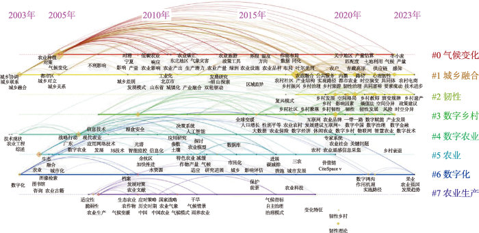
图2
农业地理学研究关键词聚类时间线图谱
Fig.2
Temporal clustering of Chinese agricultural geography keywords
图3

图3
中国农业地理学研究高频关键词共现网络图
Fig.3
Keywords co-occurrence network for Chinese agricultural geography research
从“农业地理+气候变化”(图3a)统计,主要高频关键词有农业地理、气候变化、碳排放、气象灾害、敏感性响应、可持续发展等。气候变化已经成为全球性问题。在中国,虽然研究起步较晚,研究成果较少,理论体系还不够完善,研究方法相对单一,学科之间的交叉联系还不够,但关于农业与气候变化的研究有所增加,农业农村领域的减排固碳工作对中国“双碳”目标的实现已起作用,国家对碳排放与气候变暖的问题也越来越重视。将适应气候变化融入国土空间规划体系是提升中国农业气候适应能力的关键举措[85-86],该举措强化了农业生产与气候变化之间的互动关系研究,围绕农业生产、粮食安全、气候变暖、气候适宜度、低碳农业等热点问题展开。作为世界上的农业大国,面对全球气候变暖这一重要的全球议题,为有效保障国家粮食安全、应对气候变化,有必要探讨全球气候变化对各地农业生产结果、机制、政策等方面的相互影响。
从“农业地理+自适应韧性”(图3c)统计,高频关键词发现频率最高的有农业地理、乡村韧性、自适应、生态弹性、弹性空间等。自适应韧性理论是可持续性科学的核心内容之一,提高乡村自适应韧性水平能有效应对外界扰动冲击,维持系统的稳定性,对促进乡村的高质量发展具有重要意义[88-89],随着近年来自然灾害、公共卫生等对乡村的冲击,国内农业地理学的关注视角越来越多维度,逐渐从传统的农业经济发展、农村人口流动等单个因素对农业产生的影响向整个乡村地域系统的内在结构和外在冲击等转变。危机应对、经济韧性、农业脆弱性、社会韧性等关键词在近几年出现频率较高,说明农业地理学的研究开始考虑自身的适应性和脆弱性问题,并关注乡村地域系统在受到内在变革和外在冲击时,如何有序开展规划、设计、管理等问题,研究与时俱进,具有前沿性。
从“农业地理+数字技术”(图3d)统计,高频关键词发现频率最高的有农业地理、数字技术、数字乡村、大数据、互联网+等。在全球新一轮技术变革的浪潮下,以云计算、大数据、人工智能等为代表的数字技术逐渐向乡村地域系统延伸与渗透,乡村的社会、政治、经济、文化等组织结构也随之经历着急速的重构与转型[90-91]。国内外学者在对农业地理学的研究中,通过数据平台对农业资源、产业、产品等进行集成化管理,运用现代地理信息技术和遥感技术等,使研究成果实现可视化和数据化。数字金融、智慧农业、低碳经济、农业农村现代化、数字赋能等关键词相关的研究成果较多,说明农业地理学的研究开始关注数字化技术与农业的融合,并结合地方农业特色及市场需求,对农业进行科技化的发展,关注精品农业、品牌农业和智慧农业,为农业地理发展注入数智动能。
4 中国农业地理学研究展望
近年来,农业地理研究除了立足于农业活动之外,与乡村发展也具有非常紧密的联系。总结中国农业地理的研究进程发现,中国学者主要基于农业发展的现状与困境、乡村建设的目标,以及如何顺应国家现实社会发展需要等内容展开,在农业区划、农业土地利用、农业生产、农业的现代化治理和可持续发展等领域开展了一系列研究,理论成果丰富,对实践具有较强的指导性。当前,中国农业地理的发展转入高质量发展阶段,并处于一个关键的转型发展时期,复杂多样的乡村地域系统正面临着城乡要素双向流动加剧,农业生产空间逐渐被压缩[92],新兴的生产方式、治理模式、科学技术不断融入,如何发挥中国农业地理学的特色,展开更加深入的理论研究,提升解决中国农业地理实践问题的能力将成为中国农业地理学者共同面对的问题。结合前文的网络关键词分析,主要从全球气候变化、城乡融合、自适应韧性和数字技术4个主题对中国农业地理学未来研究方向进行展望。其中:气候条件是农业生产的基础,既能提高、也能制约农业生产效率;城乡融合使农业生产生活的空间格局具备多重属性,使农业生产面临新机遇和新挑战;自适应韧性关注系统内部的自适应能力,以更好地实现农业生产生活的转型升级;数字技术通过信息化、技术化的手段,推动农业农村的高质量发展。
4.1 农业地理与全球气候变化研究
气候变化是一个影响人类社会多个系统的重大挑战[93]。如今,世界正经历着以全球变暖为显著特征的气候变化,农业的可持续发展受到严峻影响[94]。全球气候变化是指在全球范围内,并且在持续较长的一段时间内,气候平均状态所发生的变动。农业生产与气候之间存在着互动关系,适宜的气候条件为农业生产提供必要保障,而农业生产在特定条件下又可能会对气候造成影响。当前全球气候变化问题表现在温室气体增加、气温上升、海平面上升、旱涝增加等方面。作为一个全球性的问题,气候变化已引起全球各国的重视。农业农村是温室气体排放源之一,也是固碳增汇的重要方面[95],全球气候变化背景下,有序推进中国农业生产的转型是保障国家粮食安全、维持地区稳定、掌握气候谈判话语权的重要保障。
引起全球气候变化的因素呈现多样化的趋势,从农业适应气候变化的角度,研究农业节能减排技术与生产模式在不同地域的应用价值、推广难度与路径,开展各地农业水利设施完善程度评价,研究不同地域加大水利设施建设投入的贡献度差异,识别水利设施的优先建设区,探索如何兼顾生产功能和生态功能,从而实现粮食安全与碳减排双重目标。从气候变化影响农业的角度,可以探讨全球气候变化对各地农业生产及政策造成的影响,包括极端天气和气候灾害对各部门农业的破坏、气候变化与农业结构调整之间的联系、气候变化对各地粮食生产的威胁程度或机遇程度、气候变化对区域粮食生产重心的影响、气候变化推动区域农业发展新模式等。解析冰川消融和海平面上升对各沿海地区农业用地格局、农作土壤条件等因素的影响程度,将是分析气候变化背景下乡村可持续发展的重要内容。
4.2 农业地理与城乡融合研究
基于城乡融合的现实困境基础,未来的农业地理研究将持续在城乡基础设施建设、公共服务、人居环境、社会治理等方面,并侧重于补齐乡村发展的短板弱项。基于城乡融合发展机制,探讨一、二、三产业融合,如乡村产业薄弱、社会发展水平低是其人口流失的主要原因,研究在适宜区域内新型现代农业的推广模式,探讨农村吸引乡村精英回流创新创业的路径,提升农民经济收入水平,释放更多乡村的消费和投资潜力以促进城乡经济循环。通过促进农民增收和居业协同,为乡村生活空间提供便利,为乡村农业的转型提供理论支撑,提升乡村发展的质量与竞争力,逐步实现城乡一体化。
4.3 农业地理与自适应性研究
韧性研究是当下可持续发展研究领域的新兴热点,面对全球经济快速发展、各类自然灾害、公共卫生、极端事件等一系列不确定问题的冲击,农业地理的脆弱性更加明显。在乡村振兴的背景下,自适应韧性发展的研究可以通过梳理和调整农业发展内在结构,维系自身稳定发展,通过不断调整、适应、学习、演变和转型,抑制对农业发展的不良因素影响,强化农业对于不同冲击影响的适应与恢复,为中国农业地理实践中的韧性建设提供科学建设方案,使农业地理的研究方向更加开放、多维和可持续。
4.4 农业地理与数字化技术研究
随着信息化时代的到来,数字化技术深刻影响着乡村振兴的进程,为乡村文化、经济、社会、空间等发展提供高效、智能的治理模式[100],信息技术的进步无疑为农业地理学的理论研究与农业数字化建设带来了新的发展机遇。一方面,数字技术能够实现对农业地理学数据获取、空间模拟、路径演绎等过程的科学把握,有助于加强农业地理学理论的真实性、准确性、直观性,逐步构建更加科学的农业地理研究系统;另一方面,数字技术的运用强化了农业地理与计算机科学等的学科交叉,能够获取更广泛的数据内容,探索在复杂影响因素下如何实现农业地理的数字化建设、数字化管理等问题。
顺应人工智能、大数据、云计算等数字技术的发展趋势,未来中国农业地理学的理论研究与实践探索重点内容可结合数字技术手段,实现农业地理的动态数据监测,完善农业地理研究数据库,实现对农业地理研究中复杂区域系统的演变规律认识。创新研究理论,推动农业地理学与生态学、社会学、经济学、政治学等相关学科技术交叉融合,赋予农业地理新内涵的同时增强中国农业地理研究理论框架的实用性与针对性。结合农业生产生活在不同阶段的需求,充分运用现代信息技术在农业生产、农业经营、农业管理及服务等各个环节的适应性,指导数字农业发展。
参考文献
农业地理学发展述要
[J].
A review of agricultural geography development
竺可桢同志与农业地理研究, 特别是华北农业地理研究
[J].
DOI:10.11821/xb198401001
[本文引用: 1]

新中国建立以后,竺可桢同志被任命为中国科学院副院长。在科学院草创时期,他决心要在院内建立两个研究所:地质研究所主要为工业建设,查勘矿产资源,从事基础研究。地理研究所主要为农业发展进行工作。在地理研究所筹建前夕,他坚定而明确地提出他的方针。此后二十多年,他发起、推动、领导、支持与农业有关的工作,不遗余力。
Professor Chu Ko-chen (Zhu Ko-chen) and geo-graphical research on the agriculture with special reference to North China
DOI:10.11821/xb198401001
[本文引用: 1]
When the Chinese Academy of China came into existence, Professor Chu Ko-chen was appointed as its vice president. In the midst of his numerous contemplations, were his painstaking efforts to establish an institute of geography to undertake investigations for the development of agriculture in China. As the president of the geographical Society of China, he was a warm advocate of geographicl work in this direction. As chairman of the Commission of Comprehensive Survey of Natural Resources, he organized and supervised a series of multidisciplinary expeditions to various regions of this country where the physical conditions were little known to the scientific world. As a scientist, he devoted himself with the limited time available to him to researches relevant to agriculture: crop-climate relationships, phenology and climatic changes. In charge of the team work of the physico-geographic regionalization, he persistently called the attention of all participants to focus on factors bearing significance to agricultural production broadly defined, to include crop cultivation, livestock raising and forestry. He is remembered for his able and effective coordination of the activities of nine working groups of scientists of different disciplines.He was a keen observer of the agricultural problems of every region of China. But it seems to me that he was most concerned with the situation of North China: the Loess Highlands, the middle and Lower Yellow River and the vast plain where is located the capital of China. Endorsed by him, the Institute of Geography sent in 1952 two field parties, one to the middle Yellow River region between Shanxi and Shanxi and another to the abandoned course of the Yellow on the plain to the north of the Huaihe. In the next year, his centre of interest had been shifted to the soil conservation of the Loess Highlands. According to his instruction, I had joined the work and in the ensueing years, he himself had once and again made field studies in Shanxi and Gansu. He held an over-all view, strongly supporting the coordination of various measures in a drainage area. His emphasis on soil conservation on the Loess Highlands did not detract from his recognition of the importance of agricultural problems on the North China Plain. His interest in the water conservancy of the Plain dates back at least to sixty years ago. In the preparation of the multiple purpose basin planning of the Yellow River in the middle fifties, he had gone through thick and thin to materialize the organization of a large working force to map the soils of the Plain on a scale of 1:200000. In early sixties, he headed the steering committee of multidisciplinary teams under the auspices of the Academy working on land amelioration schemes for some sectors of the North China Plain. The two regions under consideration are similar in a number of respects and linked by the middle and lower Yellow River. In the opinion of Professor Zhu, the proble-ms of both regions must be solved in concert. How sure is our control of the Yellow River may serve as the barometer of how successful is our agricultural development of the areas concerned.Since the founding of the People’s Republic of China in 1949, the lower reaches of the Yellow River has been safely kept within its embankments over a period of thirty four years. This is no doubt a great feat. But the sediment discharge from the Loess Highlands to the lower course averages 1.6 billion tons each year. Some 0.4 billion tons of this is annually deposited in the river channel. The river bed is raised about 10 cm each year. The danger of flooding is ever increasing. Over the North China Plain, the crop yield is lower than the national average and varies widely from year to year. The situation with the Loess H’g-hlands is even much worse. A more and more serious problem with both regions is the shortage of water for urban, industrial and agricultural uses, The gaps between supply and demand in food and water will be widened with the growth of population. In a perspective of the said three problems in
中国城乡转型的时空格局及其优化决策
[J].
DOI:10.18306/dlkxjz.2021.11.001
[本文引用: 1]
城乡转型是一个多领域、多层次的综合过程。科学认知城乡转型的概念内涵,系统探讨城乡转型的格局、过程和机理,对于解决新时代突出的城乡发展不平衡、乡村发展不充分问题具有重要意义。在城乡转型理论认知的基础上,论文综合解析了中国省域城乡发展水平及其时空格局,并基于城乡发展水平耦合协调度剖析了城乡转型的格局,探讨了不同类型城乡转型区城乡融合发展的关键及其对策。结果表明:① 城乡转型是城市地域系统演化与乡村地域系统演化交互作用的结果,其外在表征是这2个过程耦合协调的状态;② 2000—2018年,各省城市和乡村发展水平快速上升,城乡发展水平耦合协调度实现了由濒临失调向中级协调的转变,但中西部地区的耦合协调度显著低于东北地区和东部沿海地区;③ 2000—2018年,全国城乡转型整体上实现了由低水平城乡统筹向中等水平城乡融合的转变,在空间上呈现出中西部地区城乡转型滞后于东部沿海地区的特征;④ 全国城乡发展可划分为高水平城乡融合区、中等水平城乡融合区、低水平城乡融合Ⅰ区和低水平城乡融合Ⅱ区4种类型,各类型区城乡转型的关键在于通过深化改革、创新机制、补齐短板等措施建立健全城乡融合发展的体制机制,不断推进新型城镇化发展和乡村振兴战略落实。
Spatio-temporal patterns of urban-rural transformation and optimal decision-making in China
DOI:10.18306/dlkxjz.2021.11.001
[本文引用: 1]
Urban-rural transformation (URT) is a comprehensive process with the characteristics of multi-domains and multi-levels. A scientific understanding of the concept and connotation of URT and a systematic discussion of the patterns and mechanism of URT are of great significance to solving the problems of unbalanced urban-rural development and insufficient rural development. Based on the theoretical cognition of URT, this study comprehensively analyzed the urban-rural development level and its spatial-temporal patterns in China, revealed the patterns of URT according to the coupling coordination degree of urban-rural development level, and discussed the key of urban-rural integrated development in different types of URT areas. The results show that URT is the result of the interaction between the change of urban regional system and the change of rural regional system, and its external representation is the coupling coordination state of the two different but closely related processes. From 2000 to 2018, the level of urban and rural development in all provinces of China's mainland has risen rapidly, and the coupling coordination degree of urban and rural development level has changed from being on the verge of imbalance to intermediate coordination. Spatially, the provincial coupling coordination degree of the central and western regions is significantly lower than that of the northeast and eastern regions. Accordingly, URT in China has realized the transformation from low-level urban-rural coordination to medium-level urban-rural integration, showing a spatial characteristic that provincial URT in the central and western regions lags behind the eastern areas, especially Beijing and the provinces in the Yangtze River Delta, where urban-rural development has entered or will soon enter the stage of high-level urban-rural integration. According to the features of URT in each province, URT in China can be divided into four types, that is, high-level urban-rural integrated area, medium-level urban-rural integrated area, low-level urban-rural integrated area Ⅰ, and low-level urban-rural integrated area Ⅱ. To continuously promote the development of new-type urbanization and the implementation of rural revitalization strategy, it is urgent to establish and improve the system and mechanism of urban-rural integrated development through measures such as deepening the reform, innovating the mechanism, and making up for the shortcomings.
以精准农业驱动农业现代化加速现代农业数字化转型
[J].
Accelerating the digital transformation of modern agriculture by driving the agricultural modernization with precision agriculture
生态文明建设视角下推进农业绿色发展的思考
[J].
Thoughts on promoting the green development of agriculture from the perspective of ecological civilization construction
中国县域粮食产量与农业劳动力变化的格局及其耦合关系
[J].
DOI:10.11821/dlxb201706009
[本文引用: 1]
本文构建了中国粮食产量与农业劳动力数量变化的耦合关系模式,初步探讨了县域粮食产量与农业劳动力比重变化的耦合过程。利用全国1991年、2000年和2010年3期分县截面数据,分别建立了粮劳弹性系数和农业劳动力转移效应系数用以分析中国县域粮食产量与农业劳动力变化的耦合关系。研究表明:① 中国农业转型发展过程中,县域粮食产量与农业劳动力数量变化的耦合关系呈现多样化并存的格局,1991-2010年中国县域农业劳动力数量减少而粮食产量增加、农业劳动力数量增加而粮食产量也增加和农业劳动力数量减少的同时粮食产量也减少的县域数量占县域总数的比重分别为48.85%、29.11%和19.74%;3种耦合类型分别集中于传统农区、西部欠发达牧区和农牧交错区、东南沿海农业快速转型区。② 中国县域粮食产量与农业劳动力比重的耦合曲线呈现阶梯式波动变化,且二者耦合关系的离散趋势不断加强。③ 粮劳弹性系数和农业劳动力转移效应系数的变化表明农业劳动力变化在促进粮食增产中的作用在不断下降。④ “胡焕庸线”是中国粮食产量与农业劳动力变化耦合特征的重要分界线,塑造了二者耦合格局的主体结构。
Pattern and coupling relationship between grain yield and agricultural labor changes at county level in China
DOI:10.11821/dlxb201706009
[本文引用: 1]
This paper establishes a model of coupling relationship between grain yield and agricultural labor changes, and preliminarily discusses the coupling process of the changes of grain yield and agricultural labor proportion at county level. Using county-level statistical data of farmland and agricultural labor in 1991, 2000 and 2010, two coefficients were developed to analyze the coupling relationship between grain yield and agricultural labor changes, one is grain-labor elasticity coefficient (GLEC), and the other is agricultural labor-transfer effect coefficient (ALTEC). Results showed that: (1) During the process of agricultural development transformation in China, different types of coupling relationship modes between grain yield and agricultural labor changes coexist at the same time. During 1991-2010, the number of counties with three different coupling modes, i.e., grain yield increasing and agricultural labor decreasing, both increasing of grain yield and agricultural labor and both decreasing of grain yield and agricultural labor, account for 48.85%, 29.11% and 19.74% of the total counties in the study area, respectively. Interestingly, the coupling mode of grain yield increasing and agricultural labor decreasing is mainly found in the traditional farming area of China. The coupling mode of both increasing of grain yield and agricultural labor is located in the pastoral areas and agro-pastoral ecotone in the underdeveloped western China, while the coupling mode of both decreasing of grain yield and agricultural labor is distributed in the areas experiencing rapid agricultural development transition, especially in the developed southeastern coastal China. (2) From 1991 to 2010, the number of counties which experienced a decline of agricultural labor proportion was 1961, among which 1452 counties with an increasing of grain yield, accounting for 72.38% of the total number of counties. The coupling curve between grain yield and agricultural labor proportion changes showed a stepped fluctuation, and the discrete trend of the coupling relationship was continually strengthened. (3) The mean of GLEC and ALTEC increased from -0.25 and -2.93 during 1991-2000 to -0.16 and -1.78 during 2000-2010, respectively. The changes of GLEC and ALTEC illustrated that the influence of agricultural labor changes on increasing grain yield is diminishing gradually. (4) "Hu Huanyong Line" is a significant boundary presenting the coupling relationship between grain yield and agricultural labor changes.
农业历史地理环境变迁与农业地域拓展
[J].
Historical changes of agricultural geographic environment and the development of agricultural economy
中国历史农业地理研究的世纪回顾
[J].
Academic review of china's historical agricultural geography research during 20th century
中国农业状况调查第一次报告
[J].
The first report on the investigation of agricultural situation in China
中国农业状况报告
[J].
Report on agricultural situation in China
中国农业状况报告二: 南通农业状况
[J].
Report on agricultural situation in China II: Agricultural situation in Nantong
中国人口分布与土地利用
[J].
Population distribution and land use in China
江苏省之农产区域
[J].
DOI:10.11821/xb193401004
[本文引用: 1]
江苏位于长江淮河之下游,东邻大海,南滨太湖,几全部为冲积平原所构成,除省西南部,间有若干黄土邱陵,与高达百公尺以上之山地以外,其余均为平坦原野,高于海面不足五十公尺,太湖附近及江北里下一带,地势尤为低洼,河港纷歧,灌溉极便。雨量分布,自南趋北渐减,如上海平均每年雨量一千一百四十八公厘里下河之阜宁平均每年雨量八百公厘,而省西北部铜山之雨量,则仅六百五十一公厘较上海减少几达一倍,惟下雨时期,全省均以夏季为多.
The agricultural regions of Jiangsu Province
安徽省之人口密度与农产区域
[J].
DOI:10.11821/xb193501004
[本文引用: 1]
我国人口问题,过去研究者,不乏其人,在国内有竺可桢翁文灏陈长蘅陈华寅诸氏,在国外则有洛克斯佩克莱西诸氏,或则偏於人口数字之研究,如陈长蘅陈华寅等均是,或则偏於人口分布之研究,如竺可桢翁文灏洛克斯佩克莱西诸氏均是。
Population density and agricultural production areas in Anhui Province
山西之农业区域
[J].
DOI:10.11821/xb193801005
[本文引用: 1]
抗战军兴,山西当国防之最前线,地连华北平原与西北高原,欲保华北,必保山西;欲开发『远西北』,必自此『近西北』始。其经济价值固以富藏之煤铁著称,然人民生活所资,仍以农业为主,畜牧为副。其农产分布最富地理意味,可为高原农区之代表,斯篇之作,即根据实业部之农业调查统计,作成各重要农产分布图,研究农产与地理环境之关系,阐明其分布之区域性及其所以然之原因,探讨方法,多效吾师胡焕庸先生所著江苏农业区域,安徽省之人口密度与农产区域,及中国之农业区域等篇,食粮为支持抗战之要素,足食方能足兵,战区农业之实况,想亦国人之所乐闻欤。
Agricultural region of Shanxi Province
江宁县之耕地与人口密度
[J].
DOI:10.11821/xb193402002
[本文引用: 1]
江宁位於江苏省之西南,与安徽省之当涂毗连,西北两面,滨邻长江,东界句容,南接溧水;昔日全县面积叫,原有二一九八方公里,就中陆面积二○九九方公里,水面积九九方公里;自民国十六年,南京定为首都,其城区(四二方公里)下关后湖各地,首先划分为南京市,计共面积五方公里;其陵园(二三方公里)及八卦洲之一部(五○方公里)亦以特种关系,不再隶属於江宁,因此江宁全境,计共减少一三一方公里,实余面积二○六七方公里,是为民国十六年以迄二十三年八月,实际行政所及之范围。
The cultivated areas and population density of Jiangning District
中国之农业区域
[J].
DOI:10.11821/xb193601001
[本文引用: 1]
我国幅员辽阔,全境面积,计达一千一百余万方公里,约与欧洲全洲面积相当;惟欧洲纬度,介于北纬三十五度至七十度之间,南北狭而东西宽,全洲各地气候差别不多;我国国境,位於北纬十五度至五十五度之间,纬度延长,计较欧洲多出五度.
Agricultural regions of China
DOI:10.11821/xb193601001
[本文引用: 1]
Various attempts have been made to divide China into regions of agricultural significance. Both the divisions of Nyhus and Cressey are not very satisfatory. According to my recent study, China may be divided into nine greater agricultural regions which are quite similar to the climatic regions of Co-ching Chu.
吴传钧院士对发展中国农业地理学的贡献
[J].
The contributions of academician Wu Chuanjun to modern agricultural geography in China
DOI:10.13249/j.cnki.sgs.2008.01.1
[本文引用: 1]
Academician Wu Chuanjun is a distinguished geographer as well as a geography educator in China. He was born in Suzhou city in April 2, 1918. In his more than 70 years of scientific research and education career, Academician Wu has opened up a series of important research fields in contemporary Chinese geography, and has made academic contributions for the development of China's geography, professional personnel training. Mr. Wu is hereby value of his ninetieth birthday, this paper briefly describes his outstanding contributions in terms of his work in modern agricultural geography for which we extend our sincere congratulations.Academician Wu keens on research in the field of agricultural geography more then half century; he is one of the main inaugurators of Chinese modern agricultural geography. His contributions of theory and practice in agricultural geography study are as the follows: take the lead in investigating agricultural resources, agricultural regionalization theories and methods; systematically study and synthesize the agricultural geography theory; reveal the different types and directions of regional agriculture and rural development under the recent process of the rapid urbanization and industrialization in China.
中国农业地理学研究的回顾与进展
[J].
A retrospective view of China's agriculture geography study
DOI:10.1177/194277861801100302
URL
[本文引用: 1]
This article theorizes subversive mobility by looking at the layers of meaning connoted by a set of etymologically complex words in several languages. I examine at how the semantics of words like Verkehr (German), “filibuster” (English), Yangjingbang (Shanghainese vernacular), and others, convey human experiences of physical mobility and political subversion as interconnected. This discussion is both philological and historical-geographic in orientation, using etymological inquiry to recover transportation geographies and worlds of social meaning which have become marginalized or hidden. The discussion also provides context for an analysis of the importance of not only subversive mobility but also enduring, “archaic” forms of social energy in Karl Marx's dialectical conception of history, especially towards the end of his life.
内蒙古自治区的地形条件在土地利用上的评价
[J].
Evaluation of topographic conditions on land use in Inner Mongolia
中国农业地理学研究的进展与趋向
[J].
Recent progress in agricultural geography and its trends in China
中国农业地理和土地利用的近期研究
[J].
DOI:10.11821/xb199002003
[本文引用: 1]
近十余年来,中国农业地理与土地利用的研究主要在以下方面:农业地理丛书的编写,完成了中国农业地理总论和21部分省(自治区、直辖市)的农业区域地理著作;承担全国综合农业区划、自然区划、农业各部门与农业技术条件区划,进行了农业区划理论与方法的研究;对农业发展战略与我国人口、资源与环境的国情研究;为促进农业生产稳定发展,以因地制宜为原则进行农业各部门生产布局研究;1/100万土地利用图与土地资源开发、利用和保护的研究。上述研究是持续而广泛的,在理论上和实践上都取得了很大进展。
Agricultural geography and land utilization
DOI:10.11821/xb199002003
[本文引用: 1]
For the past 10 years, besides having made public quite many works dealing with regional agricultural geography and going on with agricultural resources survey and agricultwral region-alization, much has been done in an even more extensive scope including researches on land re-sources and land utilization and crop distribution. Among furthermore studies are the strategy of agricultural development and other relevant topics. 1. Compilation of the regional geographical series, a total of 22 monographs including the general volume and the separate volwme were published one after another. This series of works reflects systematically what has been achieved in the studies of agro-geography in this country. 2. Agricultural regionalization is one of research topics in the geographical sciences, more personnel have been sent successively into the giant task from nearly all of the geographical in-stitutions and the geographical departments in to the universities across the country and more pro-fessional papers and reports. More related professional papers pertinent to theories and methods in regionalization have come out in the geographical periodicals under the sponsorship of va-rious institutions. 3. Studies on the strategy of agricultural development. Quite a number of papers on agri-cultural development strategy have come out in the geographical journals. 4. Studies on the allocation of agricultural production. Geographers have played outstand-ing role for the government department in formulating long range planning and regulating argricultural production infrastructure. 5. Studies on land utilization. Summarized into the following three aspects: the drawing of 1:1 000 000 land utilization map; studies 0n the development, utilization and protection of land resources; studies on land resources and utilization in mountainous area.
《中华人民共和国国家农业地图集》的设计特点
[J].
DOI:10.11821/xb199101009
[本文引用: 1]
《中华人民共和国国家农业地图集》是我国第一部大型综合性农业科学参考地图集。本文探讨了该地图集的设计原则。详述了地图集的设计特点:(1)以宏观农业系统思想为指导,精心选题设计;(2)全面综合地显示我国农业生产的特点和发展变化;(3)综合反映我国地学、农学、生物学的最新科研成果;(4)遥感制图、机助制图和传统制图的有机结合。
The designing features of national agricultural of the People's Republic of China
中国农业地理与乡村发展研究进展及展望: 建所70周年农业与乡村地理研究回顾与前瞻
[J].
Agricultural geography and rural development in China: Research progress and prospect
DOI:10.11820/dlkxjz.2011.04.003
[本文引用: 1]
This paper reviews the development course of the disciplines of agricultural geography and rural development in China, analyzes the related research progress, major achievements and their social impacts, and prospects for the new innovative research tasks and scientific propositions in the fields of agricultural geography and rural development to meet the needs of national strategies. In the future, there will be an obvious trend of regionalized and base-oriented agricultural production, and also an increasing trend of urbanization and industrialization in the rural development in China. As such, there is an urgent need for the innovative researches on agricultural geography and rural development to provide strong support to realize the coordinated and balanced rural-urban development, and the balance between agricultural economy and social issues, and to appropriately deal with the relationship between rural development and environmental protection. In order to keep up with the pace of the national economic development, agricultural and rural geographers should continue the tenet of geography research serving for the development of agriculture and rural areas, and solving new problems under new situations to make more contributions to meeting the needs of national strategies.
中国农业类型划分的初步研究
[J].
DOI:10.11821/xb199206004
[本文引用: 1]
农业类型是系统反映农业分布差异特征的农业生产地域综合体。我国农业生产条件复杂,地域差异显著,类型分布多样。本文按照土地利用、产值结构、集约程度、产出效益、商品化特征和农业自然条件等方面的依据指标,将全国划分为12个一级类和122个二级型。
A preliminary study of agricultural types in China
DOI:10.11821/xb199206004
[本文引用: 1]
China is an agricultural country with vast area and long history as well as complicated natural conditions and has various production types in agriculture. Classification of the agri-cultural types in China, therefore, shows great possibilities and necessities.
工厂化农业的区域创新系统
[J].
Innovation system of region in factory agriculture
经济欠发达山区农业产业化发展问题与对策: 以梅州市为例
[J].
The problems and the strategies of the development of agricultural industrialization in the undeveloped mountain areas: Taking Meizhou City for example
中外贸工农一体化经营地域模式比较研究
[J].
A comparative study on the regional models of agribusiness integration between China and abroad
我国耕地变化趋势与对策再探讨
[J].
Forecast and countermeasures of the change of the cultivated area of China
农业资源高效利用评价指标体系初步研究
[J].
A study on the evaluation index system of agricultural resources effective utility
国内外耕地利用与保护的理论基础及其进展
[J].
The theoretical basis and progress: Utility and protection of the farmer-land in foreign and home
DOI:10.11820/dlkxjz.2001.04.002
[本文引用: 1]
This article reviews the theories and progress of farmer land utility and protection, and analyzes the scientific basis and developing process of farmer land protection. This article pointed out that land productivity study is the scientific basis to ascertain the amount of the protected farmer land, that land evaluation and assessment is the basis of farmer land protection planning, and that the land plan and regulations is the shield of practice of farmer land protection. At the same time, this article further analyzes several theoretical and practical problems with farmer land use and protection in China, and some suggestions are given based on the practices of farmer land protection in foreign countries.
中国土地整理的区域差异及对策
[J].
A study on regional differences of land consolidation in China and suggestions
DOI:10.11820/dlkxjz.2001.02.001
[本文引用: 1]
Land consolidation plays an important role in rational re arrangement of land resources, increasing profit of land and keeping dynamic balance of amount of cultivated land. Therefore, it has become the focus of society attention. The denotation of land consolidation is discussed in this paper. According to the differences between eastern, middle and western regions of China, the suggestions of land consolidation are put forward combined with national target. (1)In eastern region with high economic level, high land use ratio, and serious human land contradiction, more attention should be paid to agricultural land consolidation, aiming at improvement of land quality, management and benefit associated with the adjustment of agricultural structure. At the same time, non agricultural land consolidation can be gradually performed in order to mitigate pressure of construction land against cultivate land.(2)In middle region with medium economic level and land use ratio, it is necessary to convert the objectives of land consolidation concentration from increasing quantity of cultivated land to promoting its quality, based on keeping dynamic balance of cultivated land amount.(3)For western region associated with low land use ratio and low economic level, land consolidation should not only combine with return of cultivate land to woodland and grassland as well as control of water and desert to improve environments, but promote scientific and technological input to existing cultivated land to increase its output ratio. In addition, it is urgent to constitute, revise and improve laws and regulations related to land consolidation. In order to achieve multiple collective methods of land consolidation funds, it is helpful to explore establishment of land bank and corporations’ participation in land consolidation process.
中国经济高速发展中的耕地问题
[J].我国经济高速增长过程中耕地丧失过多,使近年来农业和粮食生产徘徊,食物案例受到威胁。决策失误是造成这种局面的主要原因之一,但更深层次的原因则是农地的比较经济效益低下。本文还分析了耕地丧失的恶果,呼吁借鉴国际经验,从体制、机制、法制上采取治本之策。
Problems of farmland conservation in the rapid growth of China's economy
区域农业可持续发展指标体系及评估方法
[J].
Indicator system and appraisal method of regional agriculture sustainable development
DOI:10.11820/dlkxjz.1997.02.004
[本文引用: 1]
From the basic concept and characteristics of regional agriculture sustainable development, this paper discussed the relationship of supplement each other between regional agriculture sustainable development and territorial system science. On the basis of the four essencial objectives for regional agriculture sustainable development, i.e. food security, ecological stable, rural economic development and regional balance, the frame of indicator system for regional agriculture sustainable development was constructed in this paper. In order to evaluate the regional agriculture sustainable development, the general appraisal method was also given out.
农业地理与乡村发展研究新近进展
[J].
DOI:10.11821/dlxb201408010
[本文引用: 1]
本文首先总结了近年来国际上农业地理与乡村发展研究进展,涉及研究的领域、理论和方法及其发展趋势,随后回顾了中华人民共和国成立以来中国农业地理与乡村发展学科的研究进展、取得的重要成果及其在农业与农村发展决策实践中的应用。中国农业地理与乡村发展学科的研究进展归纳为研究成果、新方法与新技术应用、主要成果和项目影响及决策服务应用等方面。其中研究成果主要包括:① 农业与乡村地理学综合研究;② 乡村转型发展与重构;③ 新农村建设综合研究;④ 城镇化、农村空心化与空心村整治;⑤ 中心村与专业村建设;⑥ 城乡发展一体化与等值化;⑦ 区域农业与乡村发展研究;⑧ 研究成果的系统化与国际化。最后,通过比较国内外相关领域的研究进展,联系中国实际,展望了未来中国农业与乡村地理学研究。
Recent progress in agricultural geography and rural development research
DOI:10.11821/dlxb201408010
[本文引用: 1]
This paper firstly reviews the recent progress in the international research on agricultural geography and rural development, including the research fields, theory and methodology, and the developing trend. Then, the recent research progress, major achievements and their applications in economic development of agricultural geography and rural development in China are analyzed. Finally, the prospects for the new innovative research tasks and scientific propositions in the fields of agricultural geography and rural development in China to meet the needs of national strategies are put forward, based on comparison with related research progress abroad. Recent research progress includes the aspects of research achievements, the applications of new technologies and methodologies, and the influences and applications of major achievements. The summary of recent research achievements includes eight topics: (1) integrated research on agricultural and rural geography; (2) rural transformation development and rural restructuring; (3) integrated research on building a new countryside; (4) urbanization, rural hollowing and the renovation of hollowed villages; (5) the construction of key villages and specialized villages; (6) urban-rural integration development and urban-rural equalized development; (7) regional agriculture and rural development; and (8) the systematization and internationalization of research achievements.
中国农村社区演化的型式及动力机制
[J].
Evolving pattern and driving mechanism of China rural community
关于区位论发展的探讨
[J].
Inquiring into the development of location theory
基于农户调查的村域商业经济活动空间研究
[J].
Village- level commericial economic activity space based on 580 rural households surveyed
全球气候变化下中国农业的脆弱性与适应对策
[J].
DOI:10.11821/xb199603002
[本文引用: 1]
全球气候变化问题虽然还存在某些不确定性,但已得到广泛认同。对气候条件颇为敏感的农业将受影响,主要效应可概括为:①农业地理限制的变动;②作物产量的变化;③对农业系统的冲击。中国农业对气候变化与波动尤其敏感,加之人口压力进一步加大和农业资源已很紧缺,粮食自给的能力将受到严重威胁,必须充分重视适应和调整对策的研究。变动性与不确定性是气候的固有特征,在评价全球气候变化对农业的影响时应该认识到这点。本文还提出了减少农业对气候变化脆弱性的建议。
Sensitivity and adaptation of Chinese agriculture under global climate change
DOI:10.11821/xb199603002
[本文引用: 1]
Historically,China has experienced numerous climatic changes or variations.In the last hundred years,it seems that China’s climate has become generally warmer and drier.Temperature increases have been Particularly notable in the north,with less evidence of changes in South China.Records show an obvious drying trend in eastern and northwestern China since 1910.Estimations for the future climatic change include:(1) Most Parts of China l be warmer in 1990s, cooler during 2010 2030,and warmer again after 2040.(2)The greenhouse warming would strengthen the warmer period,hence the average temperature will ne in the next century,about 2℃ higher during the warmest period than that at present.In the warming process,however,there would be fluctuations in a temporal scale of 20 30years and with a extent of 0.5 1.0℃.(3)The precipitation will decrease in the east and increase in the west.China’s agricultural vulnerability to climatic change is amplified by the high degree of dependeuce on a diminishing agricultural resources base.DEspite its vast size.China is poor in agricultural resources per capita,especially cropland and water resources.On the other hand,the population will increase.So the cropland per capita will be even less.Furthermore,the productivity of cropland is hindered by water shortages.This moisture constraint on food prduction is likely to be aggravated by climate change.Investment and technology are important in adapting to climatic change.However,China’s prospects for investment and technological development in agriculture are relatively modest.There fore,the Capital put into agriculture is limited.With huge rural populations but relatively scarce scientists and technicians and with inadequate equipment in agriculture, China has very limited prospects for technological adaptation to climatic change.Most researchers agree that global climate change would impact greatly on Chinese agriculture,whatever the regional climate change may be,because Chinese agriculture is already sensitive to climate-related conditions.At least,the followings will occur:(1) A loss at least 5% of overall agricultural production as aresult of warming,because of increased evaporation.wind erosion of soil,drought,and increased frequency of typhoons.(2) Several forest species face serious losses and some forest areas will be converted to steppe,covered by non-productive hot or warm-natured shrubs and grasses.(3) Significant damage to coastal areas from even a moderate sea level rise would occur,with extensive flooding and destruction of existing salterns farm-land and fishery farms,that large food sources for coastal China.In regard to deltas,where the most productive land is found and the densest population and the richest infrastructure and settlement in China are located,half of the Zhujiang River-Delta,abut 3500 square kilometers,might be inundated,and wide scale flooding is projected for more developed areas of the Changjiang River and Huanghe River deltas.Thus the food production in China will be challenged greatly and this will happen at a time when Chinese population and living standards are increasing greatly.The future national security of food sufficiency would be in more uncertainty.The feasibility of production may shrink,the flexibility of resource-use would be less,and the vulnerability would be increased.Concerns over potential agricultural impacts of clmatic change have promoted consideration of adsptations.The question of adaptation has been approached in two ways. First,It is likely that farmers and rural communities,when faced with changed climatic conditions,will adjust their practices.Thus,any estimate of agricultural implications of changes in climate needs to consider possible "spontaneous" adaptive strategies,and the prospects for their adoption.Second.in the face of crop losses or new production opportunities associated with climatic change,public authorities may promote adjustments in the nature and organization of agricultural production,in order to minimize climate-related losses and to realize potential be
产业结构生态预警研究: 以甘肃省为例
[J].
Ecological forewarning of industrial structure: A case of Gansu Province
中国耕地转型与土地整理: 研究进展与框架
[J].
Cultivated- land transition and land consolidation and reclamation in China: Research progress and frame
基于农户行为的耕地质量评价指标体系构建的理论与方法
[J].
Theory and methodology for the construction of arable land quality evaluation system based on household behaviors
2007年中国耕地资源安全评价
[J].
DOI:10.11820/dlkxjz.2011.11.016
[本文引用: 1]
本文从耕地资源的数量安全、质量安全和生态安全3 个方面,选取14 个指标评价和分析了2007 年中国的耕地资源安全状况。本文的数据主要来源于国土资源部土地利用变更数据、农用地分等定级数据、第二次土壤普查数据和统计数据。研究显示:①2007 年,中国耕地资源安全评价分值为0.517,资源安全保障程度不高。区域上,耕地资源安全呈现出东部高、西部低的特点,高耕地资源安全省份主要有东部和中部的山东、福建、浙江等10 个省份以及西部的新疆和西藏;低资源安全省份则大多分布在西部地区,包括陕西、内蒙古、甘肃、青海、宁夏等省份。②耕地资源数量安全评价分值为0.195,资源安全分布呈现出东北部较高,黄土高原、华北平原和四川盆地较低的特点。生态退耕和建设占用带来的耕地快速减少,以及区域粮食生产定位形成的较高耕地保有量目标是造成以上地区耕地数量安全程度较低的主要原因。③耕地质量安全评价分值为0.151,呈现出东部高、东北部和西部较低的特点。区域耕地自然本底质量(耕地自然质量等别)是造成区域耕地质量安全差别的主要原因。④ 耕地生态安全的评价分值为0.171,呈现出东北部高、东部低的特点。东部地区耕地资源生态安全偏低的主要原因是化肥、农药、农膜的过量施用及其引起的土壤污染问题;西部地区耕地生态安全程度不高的主要原因是相对严重的耕地水土流失状况。
Evaluation for cultivated land resources security of china in 2007
DOI:10.11820/dlkxjz.2011.11.016
[本文引用: 1]
14 indexes about quantity security, quality security and ecological security were selected to evaluate the cultivated land resources security (CLRS) of China in 2007. The data were derived from the land use survey and the reports of agricultural land classification from the Ministry of Land and Resources of China, the Second National Soil Survey (1978) and National Bureau of Statistics of China. The results can be concluded as follows. (1) the CLRS of China is not high in 2007 with a score of only 0.517. Among the four regions, the evaluation value of CLRS is higher in eastern China but lower in western China. At provincial level, the scores of CLRS of Xinjiang and Tibet in Western China and 10 provinces of eastern China, such as Shandong, Fujian, Zhejiang, is higher than those of the others. Provinces with lower scores of CLRS are mostly distributed in Western China, including Shaanxi, Inner Mongolia, Gansu, Qinghai, and Ningxia. (2) The quantity security score of CLRS in China is 0.195, higher in Northeast China but lower in regions of Loess Plateau, North China Plain and Sichuan Basin. The quick loss of cultivated land caused by construction occupation and the policy for grainto- green and the high inventory of cultivated land in 2020 under the consideration of regional tasks for grain production are the main reasons resulting in the low quantity security score of CLRS in the three regions. (3) The quality security score of CLRS in China is 0.171, higher in Northeast China but lower in eastern China. Natural land quality is the key factor affecting regional quality security. (4) The ecological security score of CLRS in China is 0.171, higher in Northeast China but lower in eastern China. Eco-environmental problems caused by excessive use of chemical fertilizer, agricultural pesticide and agricultural film are the main reasons leading to lower ecological security in eastern China, but soil and water erosion is the key reason for western China.
粮食安全视角下的土地资源优化配置及其关键问题
[J].
DOI:10.31497/zrzyxb.20211203
[本文引用: 1]
土地资源优化配置是提高土地资源利用效率、缓解土地用途冲突、促进人地和谐发展的重要手段。当前中国土地资源优化配置研究在理论探索与实践应用方面均取得积极进展,但面对土地利用急剧变化、土地管理效率低下及生态系统退化等现实问题,传统的以“数量—空间耦合”为核心的优化配置方式已难以满足当前人类追求美好生活的需求和国土空间可持续发展的目标要求。与此同时,全球粮食安全正面临一系列严峻挑战,土地资源优化配置将直接影响并作用于粮食生产与经济发展之间的冲突协调过程。改革开放以来,南京大学立足和服务于国家战略需求与重点区域发展(长三角及沿海地区),以保障资源安全与粮食安全目标为导向,围绕土地资源优化配置开展了大量研究和实践,主要集中在耕地利用格局优化、耕地集约利用转型、耕地保护与利用规划、土地利用与城乡规划、国土整治与农用地管理、土地利用制度创新、土地经济政策优化等特色研究领域,充分发挥地理学与管理学交叉学科优势,为国家土地资源优化与可持续利用的学科发展和制度创新做出了积极贡献。综上,通过系统梳理土地资源优化配置相关研究进展,总结归纳中国土地资源配置的关键问题,进一步在回顾南京大学学术贡献的基础上提出粮食安全视角下的中国土地资源优化配置面临的机遇与挑战,试图为可持续土地利用优化提供借鉴和参考。
Optimal allocation of land resources and its key issues from a perspective of food security
DOI:10.31497/zrzyxb.20211203
[本文引用: 1]
The optimal allocation of land resources is an important means to improve land use efficiency, alleviate land use conflicts, and promote harmonious man-land development. Current research on the optimal allocation of land resources in China has made great progress in theoretical exploration and practical applications. However, in the face of rapid land use changes, inefficient land management, and ecosystem degradation, the traditional optimal allocation way based on "quantity-spatial coupling" has been unable to meet the current needs in pursuit of a better life and sustainable development goals. Meanwhile, global food security is facing a series of severe challenges. The optimal allocation of land resources will directly affect and act on the coordination process between food production and economic development conflicts. Since the reform and opening up in the late 1970s, to serve the national strategic needs and key areas development (Yangtze River Delta and coastal areas), Nanjing University has carried out much research and practice around land resources optimization, so as to achieve the goal of ensuring resource security and food security. Researchers have focused on farmland pattern optimization, farmland intensification transition, farmland protection and planning, land use and urban-rural planning, land consolidation and agricultural land management, land use system innovation, land economic policy optimization and other characteristic research fields. Research directions take advantages of interdisciplinary deveoplment of geography and management, and have made contributions to disciplinary development and institutional innovations in the optimization and sustainable use of national land resources. In brief, this paper summarizes the key issues on China's land resource allocation by systematically combing the research progress related to the optimization allocation of land resources. Furthermore, on the basis of reviewing the academic contributions of Nanjing University, the opportunities and challenges faced by the optimal allocation of land and resources in China from the perspective of food security are summarized. The research can provide references for sustainable land use optimization.
基于农户用地行为的耕地生产力及隐性损失研究
[J].
Arable land productivity and its elastic loss on the basis of farm household land use behavior
DOI:10.11820/dlkxjz.2010.07.014
[本文引用: 1]
Research on grain production capacity in China mostly put emphasis on rigid loss, and neglects elastic loss of grain productivity, especially that from the perspective of farm household land use behavior. At first, the paper elaborates, at different regional scales and temporal levels, the hierarchy of farm household land use and grain production capacity, and the impacts of farm household land use on the elastic loss of grain production capacity. Then, the research progresses in farm household land use, cultivated land intensive use and farmland productivity. We put forward a research framework of grain productivity on the basis of farm household land use and discuss the related study contents and methods. The study on the process, state, and mechanism of farm household land use behavior is the important basis for grain production capacity elastic loss evaluation. We need to explore the spatial and temporal changes of cultivated land intensive use of farm households and the impacts of the difference in intensity on farmland productivity, to analyze the intensity and the difference of elastic loss of grain production capacity at different spatial and temporal scales, and to set up the model of farm household land use-crop growth-the effects on grain production capacity. The researches include the following five aspects: (1) to analyze the mechanism of household land use, (2) to establish a farm household land use decision-making model, (3) to discuss the difference in household land use, (4) to probe into the impacts of farm household land use on grain productivity, (5) to study the change of arable land intensive use and its effects on grain production capacity. Moreover, we need to apply multidisciplinary methods to study on the elastic loss of grain production capacity, such as traditional study method in combination with remote sense information identification, GIS and spatial orientation, and we also need to make some advances in data collection.
劳动力务农机会成本对农户耕地利用决策的影响: 以河南省睢县为例
[J].
Agricultural land use responses to increasing labor opportunity cost in Suixian County of Henan Province
DOI:10.11820/dlkxjz.2010.09.007
[本文引用: 1]
<p>Increasing labor opportunity cost has become one of the most important influencing factors for agricultural land use changes. Based on 328 household survey data in Suixian County, Henan Province, this paper analyzed the types of labor employment and non-agricultural work time and wages, and then calculated the labor opportunity cost by using different labor types’ chances of getting non-agricultural job as the correction factor to amend wages. It was found that labor opportunity cost significantly affected land use practices of rural households. Households with higher labor opportunity cost always have higher nonfarm income. They are less dependent on agricultural production and more likely to lease their cultivated land to other farmers. These farmers are also inclined to grow food craps which need less labor inputs but have higher labor productivity. This results in homogenization of regional land use structure in terms of crop types. As to land use intensity, along with the increase of labor opportunity cost, labor intensity and yield -increasing inputs in agriculture decrease rapidly, while labor-saving inputs show an increasing trend. The households with larger labor opportunity cost are willing to increase machinery inputs as a substitute for labor inputs. Because of the reduction of yield-increasing inputs, the households with larger labor opportunity cost have lower grain yield per area</p>
基于生计视角的异质性农户转户退耕决策研究
[J].
DOI:10.11820/dlkxjz.2013.02.003
[本文引用: 1]
对重庆市贫困与生态脆弱区的云阳县、石柱土家族自治县376 户农户调研基础上, 将农户划为纯农户、农业主导户、非农主导户和弃农农户, 基于生计视角对农户转户退耕决策进行了解释。结果表明:①重庆市农户兼业普遍, 兼业是农户重要的生计策略;从纯农户到弃农农户, 农户生计资产依次递增, 尤其是人力资产、金融资产和社会资产。②随着兼业程度提高, 农户生计策略逐渐多元化。纯农户生计高度依赖土地;农业主导户开始选择非农兼业;非农主导户生计多样化指数最高;弃农农户生计已经转移到非农产业。③生计是影响农户转户退耕决策的关键因素:纯农户生计资产匮乏, 决策受政策导向明显;作为理性经济人, 对土地经济收益的依赖使农业主导户转户退耕意愿不明显, 对政策响应平淡;非农主导户将权衡转户退耕的补偿与损失, 政策响应模糊;弃农农户资产丰富, 对转户退耕决策响应积极。基于户籍制度改革和可持续生计视角, 本文提出了理性政府行为的3 大对策, 即:建立转户退耕的社保及补偿、激励机制;基于农户生计视角, 实施各种工程措施及惠民政策, 促进农户生计策略多元化;针对不同区位的农户实施差别化的政策。
Heterogeneous households' decision on household registration transfer and farmland relinquishment: From livelihood perspective
DOI:10.11820/dlkxjz.2013.02.003
[本文引用: 1]
In this paper, the decision on household registration transfer and farmland relinquishment is expounded through the discussion of the features of different households' livelihoods. Rural households are classified into full farm households, dominant farm households, non-dominant farm households and non-farm households, based on a survey of 376 households in Yunyang County and Stalagnate Tujia Nationality Autonomous County of Chongqing. The data were collected in October and November, 2010, using PRA (participatory rural appraisal) method. The results show that, (1) The level of concurrent business activities of the households is high in Chongqing, with non-farm income being the most important characteristics of the households' economic activities; Households' livelihood capital increases from full farm households to non-farm households in terms of labor, finance and social capital; Environmental capital is an important driving force of households' non-farm livelihood. (2) Households' livelihoods strategy has been diversified with the increase of the level of their concurrent business activities. Full farm households' livelihood is highly dependent on the land; dominant farm households begin to do some non-farm concurrent business activities; non-dominant farm households' livelihood is the most diversified; Non-farm households have set feet on construction, service and many other non-farm business. (3) Based on Efficient Market Hypothesis, the households are regarded as“rational people”, and their livelihoods (availability of capital) are considered as a key factor impacting their decisions on farmland transfer or relinquishment. In details, the full farm households, as short of capital, make their decision under the obvious influence of the governmental' guidance and are considered not fully rational; Dominant farm households show little response to the policy, due to their dependence on economic benefit of the land; Non-dominant farm households show vague response to the policy because they would judge and weigh the gain and loss of household registration transfer and farmland relinquishment; Non-farm households, possessing the most capital, response to the policy actively as rational decision-makers. From the perspectives of household registration system reform and farmers livelihoods, this article proposes rational behaviors for the government.
基于PSR模型的农区土地利用冲突强度的诊断
[J].
Diagnosis based on the PSR model of rural land-use conflicts intensity
DOI:10.11820/dlkxjz.2012.11.017
[本文引用: 1]
With the acceleration of industrialization and urbanization, rural land-use conflict has become more frequent. It is of great significance to rural development to analyze the forms of land-use conflict and assess its intensity in different rural areas. This paper presents the studies in the distinctive rural areas of Yanling County from 1990 to 2010. Using correlation analysis and principal component analysis, among the 32 driving factors in the categories of population, social economy and agriculture intensification that cause the changes of arable land-use in Yanling County, 6 major factors are identified. Based on the studies of structural changes of land-use as well as municipal policies and regulations and their effects on the social and ecological environment, an indicator system is established, and the intensity of the land-use conflict is evaluated by using Pressure-State-Response Index of Land-use (ILU). The results show that the pressure on land-use is increasing on yearly basis, the state is deteriorating, and the response is gradually strengthened. Overall, the intensity of land-use conflict in Yanling County has increased from 1990 to 2010. The three major causes for the intensified land-use conflict are as follows: (1) economic development and changes of economic structures. Increase of farmers’income brings changes to way of life and means of work, which in turn affects the composition of workforce and the choice of occupation, and then changes land-use and causes dramatic changes to the industrial structures of Yanling County, leading to intensified conflicts between arable land and construction land, and between arable land and forest land. (2) Changes of agricultural activities. The industrialization of flower and livestock business provides more economic benefits to rural households, constantly drives changes and adjustments in the structure of agricultural activities, and causes land-use conflicts. However, obviously the small business of family-owned contract service conflicts the large-scale operation required by modern agriculture. (3) Influences of the development in science and technology and the government policies, etc. Government policies serve to attenuate the land-use conflicts to some extent. From the conflict management perspective, we propose that government can regulate land-use by utilizing the self-adjustment mechanism of the market and reinforcing the policies on planning. Land-use conflict can be prevented or minimized by improving the effectiveness of land-use through multipurpose planning and balancing, and by standardizing the better ways to use the land.
东北地区土地利用多功能性演化的时空格局
[J].
DOI:10.18306/dlkxjz.2016.02.010
[本文引用: 1]
土地利用多功能性是根据社会经济目标进行土地利用的过程,是确保社会经济与生态环境协调发展的关键。本文通过构建“社会—经济—生态”三维土地利用多功能性评价指标体系,对1990-2013年东北地区土地利用多功能性进行综合评价,旨在阐释其土地利用多功能性演化的时空格局。研究表明:1990-2013年东北地区土地利用功能值均呈现上升态势但增速有所差异,黑龙江、吉林、辽宁土地利用功能发展程度依次递增,其年均增长率分别为2.976%、2.725%、2.261%;黑龙江和吉林社会功能值呈现波动性增长,辽宁则表现为阶段性变化;黑龙江经济系统功能值逐渐增大,而吉林和辽宁经济功能值总体呈现上升趋势,但在2000-2005年有所波动;黑龙江与吉林生态系统功能值呈现由基本稳定转变为波动增长的趋势,而辽宁则始终具有较大波动性;经济功能中的土地的生产功能与交通功能对东北地区省域土地利用功能均有较大影响,经济和社会因素对黑龙江与吉林土地利用功能多样性影响较大,生态因素则对其影响较小,而经济、社会和生态因素对辽宁土地利用功能均有较大影响。
Spatiotemporal patterns of multi-functionality of land use in Northeast China
DOI:10.18306/dlkxjz.2016.02.010
[本文引用: 1]
Multi-functionality of land use is the result of the process of land utilization according to the socioeconomic goals, which is the key to ensuring the coordinated development of the socioeconomic and ecological environments. By constructing a social-economic-ecological multi-functional land use evaluation indicator system, this article comprehensively examines the multi-functionality of land use from 1990 to 2013 in Northeast China, which aims to explain the spatiotemporal patterns of multi-functionality of land use in the area. The results show that functional values of land use showed an upward trend during 1990-2013 in Northeast China, but the growth rates differed. The development levels of land use functions in Heilongjiang, Jilin, and Liaoning Provinces were in an ascending order, and the average annual growth rates were 2.976%, 2.725%, and 2.261%, respectively. The social function values of Heilongjiang and Jilin Provinces increased with some fluctuations, but Liaoning Province showed a periodical change. The economic function values of Heilongjiang Province increased, but that of Jilin and Liaoning Provinces showed an overall upward trend yet fluctuated in 2000 to 2005. The ecological function values of Heilongjiang and Jilin Provinces were stable at the beginning of the period then showed an increasing trend with some fluctuations, whereas in Liaoning Province it always showed greater volatility. Land production and transportation, which are important parts of the economic function, had a great impact on the land use functionality of the three provinces in Northeast China. Economic and social factors had a greater impact on the multi-functionality of land use in Heilongjiang and Jilin Provinces, while ecological factors played a smaller role. But in Liaoning Province, economic, social, and ecological factors all had important impacts on the multi-functionality of land use.
沿海滩涂围垦区土地生产潜力模型构建与应用: 以江苏省如东县为例
[J].
DOI:10.18306/dlkxjz.2015.07.008
[本文引用: 1]
沿海淤泥质滩涂是中国重要的耕地后备资源之一,滩涂围垦新增的大量耕地资源的生产潜力能反映滩涂土壤粮食安全保障能力大小。本文以江苏省如东县滩涂围垦区为例,在现有的光温水气候生产潜力模型的基础上,引进基础地力贡献率和盐分限制因子作为土壤有效性系数,构建沿海地区土地生产潜力模型,并通过水稻和小麦产量对模型结果进行初步验证。研究表明:该模型具有一定可行性。滩涂围垦区水稻产量土壤基础地力贡献率为55%~59%;小麦基础地力贡献率为50%~80%。未脱盐的1982年滩涂围垦区水稻和小麦产量受到盐分阻碍的系数分别为0.73和1.00。2007年垦区由于盐分太高不能种植水稻,小麦产量受到盐分阻碍系数为0.35。未脱盐的1982年滩涂垦区土壤基础地力修正后的水稻和小麦土地生产潜力分别为12235.84和6502.23 kg/hm<sup>2</sup>;土壤盐分修正后的土地生产潜力分别为15677.42和10329.39 kg/hm<sup>2</sup>;土壤基础地力和盐分共同修正后的土地水稻和小麦生产潜力分别为8934.97和6502.23 kg/hm<sup>2</sup>。与实地调查的水稻产量(9750 kg/hm<sup>2</sup>)和小麦生产潜力(6000 kg/hm<sup>2</sup>)相比,目前土地生产力远小于盐分限制下的土地生产潜力,与基础地力和盐分双重限制下的土地生产潜力接近,改善土壤施肥技术可以进一步提高土地生产力。
Potential land productivity of the coastal reclamation zones of Rudong County, Jiangsu Province
DOI:10.18306/dlkxjz.2015.07.008
[本文引用: 1]
The Jiangsu muddy coastal zone is one of the key bases of cropland complementary resources in China. In 2009, the Chinese government approved the development plan of the Jiangsu coastal zone, wherein the tidal flat will be reclaimed and developed into new farmland. Potential land productivity in the coastal area can reflect its capacity to supply food for the country, and is the basis for maintaining the sustainability of the regional agricultural production. There exist various potential land productivity models in China and worldwide. Models based on the process of crop physiology and ecology were used at the field scale, such as the Crop-Environment Resource Synthesis System (CERES) and World Food Studies (WOFOST). Land productivity models based on light, temperature, precipitation, and soil properties—the Classification and Evaluation Techniques of Farmland and Evaluation System of Land Productivity (ESLP)—have been used in China. However, the soil validation coefficients in these two models are based on the evaluation of soil quality and did not consider the relationship between crop yields and soil properties. This article takes the reclamation zones in Rudong County, Jiangsu Province as a case study and attempts to improve the soil validation coefficient in potential land productivity models. It incorporates the percentage of soil fertility contribution (PSFC) and soil salinity factor as soil validation coefficients into the model of potential land productivity to reflect the quality of land. We used the field survey data on rice and wheat yields to verify the feasibility of the potential land productivity model in the coastal area of China. The results show that the PSFC of rice production in the Jiangsu coastal area was about 55%~59%. The PSFC of wheat production in the study area was 50%~80%. The rice and wheat production in the reclamation zones in 1951 and 1974 was not affected by soil salinity because the soils in these reclamation zones were not saline. The rice and wheat production in the reclamation zones in 1982 and 2007 were influenced by soil salinity. The salinity factors of rice and wheat production in the reclamation zones in 1982 were 0.73 and 1.00, respectively. The salinity factors of rice and wheat production in the reclamation zones in 2007 were 0 and 0.35. In 2007 the soil in the reclamation zone was no longer suitable for growing rice paddy. The rice and wheat potential productivity corrected by PSFC in the un-desalinized reclamation zones in 1982 were 12235.84 and 6502.23 kg/hm2. The rice and wheat potential productivity corrected by soil salinity in the un-desalinized reclamation zones in 1982 were 15677.42 and 10329.39 kg/hm2. The rice and wheat potential productivity corrected by PSFC and soil salinity in the un-desalinized reclamation zones in 1982 were 8934.97 and 6502.23 kg/hm2. The actual field yields of rice and wheat (9750 and 6000 kg/hm2) are consistent with the potential productivity corrected by PSFC and soil salinity, and is far less than the potential productivity corrected by soil salinity. Improved fertilization can increase land production. The result of this research can be useful for evaluating newly reclaimed farmland resources and for calculating crop production in the coastal reclamation zones.
江苏省粮食生产时空变化的影响机制
[J].
DOI:10.11820/dlkxjz.2009.01.017
[本文引用: 1]
利用1999-2006 年县域统计数据,借助面板数据模型,对江苏省粮食生产时空变化的影响机制进行了系统 分析。结果表明:粮食播种面积是影响粮食生产时空变化的相对活跃因素;城镇化、工业化因素通过比较经济效益 对全省粮食生产产生一定程度的负向影响;粮食生产支持政策对全省粮食生产恢复起到积极作用,并且这一支持 政策对三大地区、不同收入水平地区的粮食生产促进效应存在差异,体现在对苏北、低收入地区的促进作用较强, 而对苏南、相对高收入地区的促进作用较弱。鉴于江苏省粮食生产的时空变化和政策效应的区域差异,适应此特征 的粮食生产发展战略和补贴政策设计需及时响应。以统筹城乡和区域发展为契机,减少耕地非农占用,优化土地资 源城乡配置,加强农业基础设施建设,完善和强化粮食补贴机制,有助于促进江苏粮食生产持续发展与供需平衡。
Influencing mechanism of spatio-temporal variation of grain production in Jiangsu Province
DOI:10.11820/dlkxjz.2009.01.017
[本文引用: 1]
Food security is an extremely important factor which affects the regional and national socio-economic stability and development. By using county level statistic data from 1999 to 2006, this paper analyzes the influencing mechanism of spatio-temporal variation of grain production in Jiangsu Province based on panel data model. The results showed that: (1) grain planting area was a relatively active influencing factor on spatio-temporal variation of grain production in the study area; (2) urbanization and industrialization had a negative effect on grain production; and (3) agricultural policies which were devoted to promote grain production played an active role in the recovery phase. Moreover, the effects of these policies were different in southern, middle and northern Jiangsu and regions with different income levels of rural households. In detail, the effects on northern Jiangsu and regions with low income level were statistically significant but that on southern Jiangsu and regions with high income level were not the case. In view of the spatio-temporal variation of grain production and regional difference of policy effect, the development strategy of grain production and subsidy policy design should make a quick response. The macroscopic strategy of integrating urban-rural development and regional development provides an opportunity for improving the grain production and supply -demand balance of Jiangsu Province. Thus, for this purpose, the local government should protect the scarce farmland energetically, optimize the allocation of rural-urban land resources, strengthen agricultural infrastructure construction, and improve the subsidy policy of grain production.
中国粮食主产区农业碳排强度估算及其分析
[J].
Intensities of agricultural carbon emissions and their causes in the major grain producing areas in China
DOI:10.11820/dlkxjz.2012.11.016
[本文引用: 1]
While the major grain producing areas in China play a vital role in agriculture, they have become the main source of agricultural carbon emission. Thus scientifically assessing current intensities of agricultural carbon emissions, discrepancies between the areas, and major causes in those areas is an essential prerequisite for making sound policies leading to reduction of agricultural carbon emission. To that end, based on 16 indexes, using principal components analysis, this paper presents the measurement of the agricultural carbon intensity in 13 major grain producing provinces. It shows that the carbon intensities of Hunan, Shandong and Hubei are among the highest three, while those of Jilin, Heilongjiang and Inner Mongolia are among the lowest three. An evaluation matrix of carbon intensity vs. benefits is then created to regroup the 13 areas. As shown in the results, Hunan, Jiangxi, Henan and Anhui are the high-intensity low-benefits areas; Hubei, Jiangsu and Shandong are thehigh- intensity high-benefits areas; Sichuan and Hebei are the low-intensity low-benefits areas; Heilongjiang, Jilin, Liaoning and Inner Mongolia are the low-intensity high-benefits areas.
干旱环境胁迫下农户适应性研究: 基于民勤绿洲地区农户调查数据
[J].
DOI:10.18306/dlkxjz.2016.05.011
[本文引用: 1]
适应能力及其评估框架为农户生计研究提供了一个新思路。本文在干旱环境背景下,借鉴农户可持续生计和适应能力相关理论,探讨民勤绿洲地区农户适应能力及适应行为。按照适应能力评估框架,构建农户适应能力评价指标体系,通过问卷和实地调查获取数据,在农户适应行为分类的基础上,测量不同适应类型农户的适应能力,分析影响农户适应类型的因素。结果表明:①从农户的适应行为来看,积极主动的适应行为选择较多,减少消费、参加社会保险等适应行为选择较少;农户适应类型中,综合适应型的比重最大,被动适应型最小。②农户的适应能力方面,各维度整体分布较为均衡,但自然能力和社会能力存在显著分异,而物质能力、金融能力、劳动能力和学习能力较均衡;不同农户适应类型中,综合适应型农户适应能力更稳定,务工主导型和被动适应型的稳定性较差。在适应能力六大维度中,物质能力在六大农户适应类型中所占比重最大,自然能力最小。③家庭物质资产、非农就业比重、社会网络、人均“退还关压”面积、受教育程度等适应能力指标对农户的适应行为选择具有显著影响。
Adaptation of farming households under drought stress: Based on a survey in the Minqin Oasis
DOI:10.18306/dlkxjz.2016.05.011
[本文引用: 1]
Adaptive capacity and its evaluation framework provide a new direction for the study of livelihoods of farming households. Considering the arid environment and based on theories about sustainable livelihoods of farming households and adaptive capacity, this article explores adaptive capacity and adaptive actions of farmers in the Minqin Oasis area. An adaptive capacity assessment index system of farming households was constructed. The research data were collected through a questionnaire survey and field investigations. Based on the classification of adaptive actions of farmers, this research measured the adaptive capacity of different adaptive types of farming households and analyzed the influencing factors of farmers’ adaptive types. The results are as follows: (1) With regard to the adaptive actions of farmers, more people chose active adaptive actions, while those who opted for reducing consumption and participating in social insurance were fewer. With regard to the adaptive types of farmers, the proportion of farming households that adopted comprehensive adaptation was the largest, whereas passive adaptation was adopted by the smallest number of households. (2) In terms of the adaptive capacity of farmers, generally speaking in each of the six dimensions a relatively balanced distribution was observed across different types of farming households, but there were significant differences between farming households with regard to natural resource endowments and social resources. On the other hand, material possession, financial resources, labor resources, and education were more balanced. Among different adaptive types, the adaptive capacity of comprehensive adaptation type was more stable, but the stability of migrant worker-dominant adaptation and passive adaptation types was poor. In the six dimensions of adaptive capacity and six adaptive types of farming households, material possession accounted for the largest contribution to adaptive capacity, while natural resource endowments contributed the least. (3) Among the indicators of adaptive capacity, household physical assets, proportion of non-agricultural employment, social network, per capita area of “returning farmland to forest and cutting down wells and field”, level of education, and so on had significant influences on farmers’ choice of adaptive actions.
农业多功能的地域类型与优化策略: 以吉林省为例
[J].
DOI:10.18306/dlkxjz.2019.09.008
[本文引用: 1]
中国农业的发展正面临可持续发展、消费者需求变化、全球化的挑战。农业供给侧改革和乡村振兴背景下,应深入研究农业多种功能的空间格局、地域类型和优化策略。论文首先简要探讨了多功能农业的发展过程和农业功能时空差异的理论基础,然后以吉林省为例,构建了农业多功能的评价指标体系,采用聚类分析等方法,对农业多功能的地域类型及优化策略进行了实证研究。研究表明:① 农业多功能具有联合生产和外部性特征,经济社会发展阶段、农业资源禀赋以及两者的组合作用,是导致农业多功能时空分异的关键因素;② 吉林省县域农业各功能的空间分异具有不同特征,农产品供给功能高值县域主要分布在中西部松辽平原,经济发展功能高值县域主要为大农业发达的县域,社会保障功能高值县域主要为东部城镇化水平高且劳均农业产值高的县域,生态服务功能高值县域主要为林地、草地、水域面积占比高的东部和西部县域;③ 吉林省县域农业多功能的地域类型可分为4类,即农产品供给优势区、多种功能并重区、非生态功能弱势区和生态服务优势区;④ 不同农业多功能的地域类型具有不同的功能组合特征和区域发展背景因素的结构性差异,应有针对性地采取差异化的发展策略。
Territorial types and optimization strategies of agriculture multifunctions: A case study of Jilin Province
DOI:10.18306/dlkxjz.2019.09.008
[本文引用: 1]
China's agricultural development is facing the challenges of sustainable development, changing consumer demands, and globalization. More attention should be paid to the spatial patterns, territorial types, and optimization strategies of multiple agriculture functions. This study briefly reviewed the development of multifunctional agriculture and discussed the theoretical basis of the spatiotemporal differentiation of agriculture multifunctions, and studied the territorial types and optimization strategies of agriculture multifunctions at the county level in Jilin Province by using cluster analysis method and so on. The results demonstrate that: 1) Agriculture multifunctions have the characteristics of joint production and externality. Endowment of agricultural resources, socioeconomic development stages, and their interactions play key roles in the spatiotemporal differentiation of agriculture multifunctions. 2) The spatial differentiations of agriculture functions at the county level in Jilin Province present different characteristics— the high values of agricultural products supply function are mainly distributed in the Songhua River-Liao River Plain; the high values of economic development function are located in counties with strong featured agriculture; the high values of social security function are distributed in highly urbanized counties with high per capita agricultural output value; and the high values of ecological service function are located in counties that have a large proportion of forest, grassland, and water areas. 3) Agriculture multifunctions at the county level in Jilin Province can be divided into four types: agricultural products supply dominated, multiple functions balanced, non-ecological functions disadvantaged, and ecological service dominated. 4) Different territorial types of agriculture multifunctions have different combinations of multiple agriculture functions and development backgrounds, and targeted development strategies for them should be implemented.
中国区域农业生态效率空间演化及其驱动因素: 水足迹与灰水足迹视角
[J].
DOI:10.13249/j.cnki.sgs.2021.02.012
[本文引用: 1]
将水足迹与灰水足迹指标纳入农业生态效率指标体系,运用基于非期望产出的SBM模型和Tobit面板模型对1990—2016年中国农业生态效率空间演化特征及驱动因素进行实证分析,结论如下:① 1990—2016年,中国农业水足迹和灰水足迹明显上升;中国高农业水足迹的区域重心北移,主要由长江流域转移至黄河下游地区。中国高灰水足迹地域范围明显扩大,整体由西南向东北方向移动;② 中国农业生态效率明显降低。中国农业生态效率存在明显的区域特征。华南区的农业生态效率最高。东北区、西北及长城沿线区、青藏区和西南区的农业生态效率较低,这些区域是中国农业污染治理防控的重点区;③ 中国省域农业生态效率呈现显著的空间自相关且空间上越来越趋于集聚。中国农业生态效率的空间集聚格局较为稳定,呈空间依赖与路径锁定特征;④ 中国七大区域农业生态效率演变的驱动因素存在异质性。提出中国提高农业生态效率要因地制宜采取差异化的发展策略,为促进中国农业生态效率提升和可持续发展提供科学参考。
Spatial evolution and its drivers of regional agro-ecological efficiency in China's from the perspective of water footprint and gray water footprint
DOI:10.13249/j.cnki.sgs.2021.02.012
[本文引用: 1]
The water footprint and gray water footprint are integrated into the input and output index system, and the agro-ecological efficiency and spatial distribution pattern of China from 1990 to 2016 are analyzed using the SBM model based on undesired output, and Tobit panel model mothoods. The main findings are as follows: 1) From 1990 to 2016, agricultural water footprint and gray water footprint increased significantly; The regional center of gravity of high agricultural water footprint moved northward, and transferred from the Yangtze River basin to the lower reaches of the Yellow River. The range of high ash water footprint in China is obviously expanded, and the whole area of ash water footprint moves from southwest to northeast; 2) China’s agricultural ecological efficiency is obviously decreasing, and there are obvious regional characteristics in China’s agricultural ecological efficiency. The agricultural ecological efficiency in South China is the highest, while that in Northeast China, Northwest China, regions along the Great Wall, Qinghai and Tibet, and Southwest China is relatively low. These regions are the key areas of agricultural pollution control and prevention in China; 3) The results show that there is a significant spatial autocorrelation of agricultural ecological efficiency in China, and it tends to gather more and more spatially; 4) There are differences in driving factors of agricultural ecological efficiency evolution in seven regions of China. It is suggested that China’s agricultural ecological efficiency should be adapted to local conditions and differentiated development should be adopted. This article provides a reference for promoting agricultural ecological efficiency and sustainable development in China.
中国省际农业生态效率评价及其改进路径分析
[J].
Evaluation and improvement of agricultural eco-efficiency in China
2008年中国种植业地理集聚与专业化格局
[J].
Geographical agglomeration and specialized pattern of planting in China based on the different classifications
DOI:10.11820/dlkxjz.2012.08.010
[本文引用: 1]
There has been less current literature on the pattern of Chinese agricultural geographic concentration and specialization. This paper discusses the geographic concentration pattern of China's planting in 2008. Through calculating the average Gini coefficient (0.46,0.66 and 0.68, respectively), the average Moran’s I index (0.11,0.18 and 0.20, respectively ) and the Location quotient (LQ ) in the three scale classifications at the provincial level, it is found that the planting in China presents certain geographic concentration and exposes different agglomeration degree at different levels of industrial classification. And the finer division of planting industry, the more obvious the trend of spatial concentration and specialization of production. At the macro-planting level, the distribution of crop production is relatively dispersed, while at the micro-planting level, the distribution of crop production shows the trend of more agglomeration and specialization. The regional specialized production pattern in Chinese planting has emerged. The regional specialized degree of the staple crops is low, and that of the commercial crops is relatively high. Although the specific pattern of spatial concentration is determined by the matching between the natural conditions and production conditions of various crops, the government decision-making, institutional changes and other social factors plays an important role in regional specialized production functioning as the optimization and adjustment to the natural gathering. So, by calculating the spatial autocorrelation and the Gini coefficient, specialized index in various types of crops grown in contiguous spatial patterns, the potential location of the agricultural regional specialization and large-scale production can be identified, which can help the government make specific agricultural policies in different regions.
中国农业现代化发展水平空间分异及类型
[J].
DOI:10.11821/dlxb201402006
[本文引用: 1]
农业现代化是社会文明进步的重要表征,是中国“四化”同步发展的重要内容。本文从地理学视角,构建指标体系,对中国农业现代化发展水平进行综合评价,并在此基础上进行空间分析及类型研究,探讨中国农业现代化发展的地域分异规律,以期为中国农业现代化的快速稳步推进提供参考。结果表明:① 从全国层面来看,中国农业现代化发展水平以“胡焕庸线”为界,划分为“东西两侧”,总体上呈现“东高西低”的空间格局,同时其在“东西两侧”整体上也表现出距“胡焕庸线”距离的增加而不断提高,在空间上呈现出一条稍被拉平的“S”型曲线的分异形态;② 从局部层面来看,中国农业现代化发展水平在东部、西部、中部以及东北地区具有明显的地域差异性,在空间上呈现出从东部→东北部→中部→西部依次递减的趋势;③ 中国农业现代化发展水平4 个分维度指标在地理空间上也表现出一定的地域分异格局,因此,如何打破农业发展的传统模式与路径依赖,将是各级政府与地理学者应关注的现实难题与科学问题;④ 中国农业现代化发展水平可划分为5 大类型区,不同类型区应明确现阶段及未来的发展思路与策略。
The spatial distribution and types of the development level of Chinese agricultural modernization
DOI:10.11821/dlxb201402006
[本文引用: 1]
The modernization of agriculture is a crucial symbol of the progress of social civilization, and an essential part of China's "four modernizations" of the simultaneous development. From the geographic perspective, this paper tries to comprehensively evaluate the development level of agricultural modernization in China by building index system with multi-index comprehensive evaluation method and Delphi method. Besides, it uses some spatial analyses and type researches to explore the regional differentiation law about the development of agricultural modernization in China in order to provide reference for its rapid and steady development. The results indicate that: (1) From the national level, Chinese agricultural modernization development level can be categorized into the eastern and western parts according to Hu's line, presenting a pattern of "high east and low west". At the same time, Chinese agricultural modernization development level improves on the whole with the increase of distance from Hu's line, presenting a pattern of slightly flattened "S" curve; (2) From the local perspective, there are obvious regional differences in the development level of agricultural modernization among the eastern, western and central regions and Northeast China, and in space a trend of decrease is found in the development level of agricultural modernization from the east, north-east, center to the west; (3) The four sub-dimensions indicators of the development level of Chinese agricultural modernization in the geographical space also reveal some regional differentiation pattern, and how to break the stereotype and path dependence of agriculture development will become the practical problem and scientific issue for government at all levels and geographers; (4) The development level of Chinese agricultural modernization can be divided into five types of areas and different areas should have clear present and future development ideas and strategies.
近30年中国农作物种植结构时空变化分析
[J].
DOI:10.11821/dlxb201605012
[本文引用: 1]
综合运用时序变化趋势、空间集聚分析等方法,从种植结构类型和种植比例变化趋势分析了1980年以来中国县域种植结构的时空特征。结果表明:① 近30年来中国前10位的种植结构类型有16种,2002年后多元种植结构逐步替代单一型种植结构。粮食作物占优的单一种植结构类型呈逐年递减趋势,其中1980年全国82.7%的县级农业种植结构是水稻、小麦、玉米及其组合种植类型,2002年后的果蔬类型增加改变了种植结构格局。② 全国种植县中有47%的水稻、61%的小麦和29.6%的玉米的种植比例显著减少,其他作物呈现增加趋势。粮食作物由以水稻为主的格局调整为水稻、小麦和玉米共存格局,其中玉米种植面积比例在空间上变化最为显著,在中国形成北东—西南向的“玉米减少带”。种植结构调整热点的城市地区,城市化对种植结构变化影响显著,水果和蔬菜类种植比例在城市化地区快速增加。③ 种植结构变化趋势在1300个县形成空间集聚效应,水稻的高高聚集占全国县数的2.86%、小麦占5.64%、玉米占6.11%、大豆为4.53%、麻类为1.62%、棉花占7.77%、蔬菜占8.24%、薯类占12%、水果占10%、糖料占1.41%、油料占9.35%,主要分布于中国东北、新疆和沿海的城市化地区。
Spatio-temporal changes in Chinese crop patterns over the past three decades
DOI:10.11821/dlxb201605012
[本文引用: 1]
The study aims to investigate the spatio-temporal changes in crop patterns in China since 1980. In doing so, the analysis methods of time-series trend and spatial cluster were used to cover the major eleven crops at county scale. The results indicate that (1) There are 16 kinds of crop combinations ranking in the China's top 10 during the past 30 years. Yet since 2002, the simplified cropping structure has been gradually replaced by the multiple cropping structure, which suggests an increase in the diversity index of crop patterns. In 1980, about 82.7% of China's counties have a similar crop pattern which is composed of rice, wheat, corn and their combinations, however, this pattern largely changed after 2002 due to the increase in the planting area of fruit and vegetables. (2) In the same period, rice planting area of 47% of the counties, wheat planting area of 61% of the counties of and corn area of 29.6% of the counties experience a significant decrease, while other crops show an increasing trend. As a result, rice-dominated cereal crops in China are slightly adjusted to the coexistence of rice, wheat and maize crops. In particular, maize area proportion shows a significant change, which forms a so-called "corn decreased belt” spanning from northeast to southwest of China. Urbanization had an important impact on crop patterns as fruit and vegetable planting areas rapidly grow so as to meet the increasing demands in urbanized areas. (3) Crop patterns also show an obvious spatial cluster effect in China's 1300 counties. The proportion of high cluster accounts for 2.86%, 5.64%, 6.11%, 4.53%, 1.62%, 7.77%, 8.24%, 12%, 10%, 1.41% and 9.35% of China's counties for rice, wheat, maize, soybean, fibers, cotton, vegetables, potatoes, fruits, sugars and oils, respectively. These crops are distributed in Northeast China, Xinjiang, Northern Shaanxi Plateau, Yunnan-Guizhou Plateau and the metropolis areas. This finding of this study can support the decision making in agricultural restructuring and adaptation to climate change.
广西主要农作物生产格局演变特征与机制研究
[J].
DOI:10.11821/dlxb202209013
[本文引用: 1]
农作物生产结构与布局是农业地理学探讨的传统研究主题,开展农作物生产格局演变特征与机制研究,可为区域农业生产要素的优化配置提供参考依据。论文运用区位基尼系数、重心移动模型、比较优势指数等方法,揭示1995—2019年广西粮食、糖料、水果和蔬菜4类主要农作物生产格局的演变特征,剖析其形成机制,据此提出相关优化建议。结果表明:粮食作物“退”、糖果菜“进”构成主要农作物竞争的基本态势;粮食、蔬菜生产空间分布相对分散,糖料生产地理集聚趋势明显,水果生产由相对集中走向分散;主要农作物综合比较优势受规模比较优势主导,粮食生产劣势明显,糖料生产具有绝对规模比较优势和综合比较优势,水果、蔬菜生产规模比较优势突出但效率比较优势有待提升。资源禀赋的约束、市场供需和比较效益的主导、乡村社会发展要素变化的诱发、制度环境的引导/修正、集聚经济的循环累积等多种力量综合作用推动农作物生产格局的演变。特殊的区情决定了广西农作物生产应统筹经济功能、社会功能和生态功能,通过结构调整、产业集聚、空间优化,推进农作物生产从规模扩张向综合效益提升转型。
Evolution characteristics and mechanism of major crops production patterns in Guangxi
DOI:10.11821/dlxb202209013
[本文引用: 1]
Crop production structure and layout is a traditional research content of agricultural geography, and the research on the evolution characteristics and mechanism of crop production pattern can provide some reference for the optimal allocation of regional agricultural production elements. In this paper, we use the location Gini coefficient, gravity center movement model and comparative advantage index to reveal the evolution characteristics of the production pattern of four major crops, i.e., grain, sugar, fruits and vegetables, in Guangxi from 1995-2019 and their formation mechanism, and accordingly put forward relevant optimization suggestions. The results showed that grain crops "retreating", and sugar, fruits and vegetables "advancing" constitute the basic situation of the major crops competition. In terms of spatial distribution, the grain and vegetables are relatively scattered, the sugar production has an obvious trend of geographical agglomeration, and the fruit production has moved from relative concentration to dispersion. The scale comparative advantage of major crops dominates the aggregated comparative advantage, and the weak position of grain production is gradually strengthened. Sugar production has the absolute scale and aggregated comparative advantages. Fruits and vegetables have a prominent scale comparative advantage, but the efficiency comparative advantage needs improvement. The combination of forces such as the constraints of resource endowments, the dominance of market supply and demand and comparative efficiency, the inducement of changes of rural social development factors, the guidance or correction of institutional environment, and the circular accumulation of agglomeration economy, all together drive the evolution of crop production patterns. The unique regional situation determines that Guangxi's crop production should coordinate economic, social and ecological functions, and promote the transformation of crop production from scale expansion to comprehensive benefit enhancement by adjusting production structure, optimizing the spatial layout and strengthening industrial agglomeration.
农业结构调整与中国乡村转型发展: 以河南省巩义市和鄢陵县为例
[J].
DOI:10.18306/dlkxjz.2018.05.013
[本文引用: 1]
农业转型升级是中国乡村转型发展的主要引擎。而规模化、专业化生产是国际农业转型升级的方向。本文以两个不同乡村转型道路的典型县域(工业化转型的巩义市和农业现代化转型的鄢陵县)为例,利用区位熵、结构变化指数和专业化指数,在乡镇尺度深入分析新世纪以来乡村经济转型发展背景下乡村农业结构调整状况,以及由此带来的乡村景观再造。主要结论为:①基于市场需求的农业结构调整与乡村转型之间的相互作用是农产品提质增效倒逼耕地利用方式的现代化转变,并引致乡村景观的多功能再造。未来中国农业的转型方向将是规模化大宗农业与专业化精细农业并存;②无论是乡镇的非农化转型还是农业现代化转型,均可带来乡镇耕地的规模化、专业化利用以及农业内部的结构调整,并引致乡村的进一步转型。工业转型县农业结构以粮食作物为主要调整方向,农业现代化转型县以粮食和特色农作物为主要调整方向,并形成了特色专业村或产业集群;③农业结构调整方向更加与自然条件和资源禀赋相匹配,空间配置更加合理。
Agricultural structure adjustment and rural transformation development in China: Taking Gong-yi City and Yanling County as examples
DOI:10.18306/dlkxjz.2018.05.013
[本文引用: 1]
Agricultural structure adjustment and upgrading is the main engine of Chinese rural transformation development, while large-scale and specialized production is the direction of such transformation in agriculture internationally. This study took an industrialized transformation county—Gongyi City and an agricultural modernization transformation county—Yanling County as examples, and used location quotient, structural change index, and specialization index, to analyze agricultural structure adjustment and reconstruction of rural landscape on the township level under the background of rural economic transformation. The conclusions are as follows: (1) The interaction between demand-based agricultural structure adjustment and rural transformation comes into being through the modernized change of cultivated land use, the quality improvement of agricultural products, and the multi-functional reconstruction of rural landscape. In the future, large-scale agriculture in grain production and specialized precision agriculture will co-exist in China; (2) Basically non-agricultural transformation and agricultural modernization transformation of rural economy both can bring the large-scale as well as specialized use of rural land and internal structure adjustment of agriculture. The industrialized transformation county takes grain crops as the main agricultural structure adjustment direction, and the county with agricultural modernization transformation adjusts towards grain crops and featured crops, forming specialized villages or agricultural clusters for production; (3) The adjustment of agricultural structure is aligned with natural conditions and resource endowments better than before, and spatial distribution is more optimized.
农业生产转型类型诊断及其对乡村振兴的启示: 以黄淮海地区为例
[J].
DOI:10.18306/dlkxjz.2019.09.006
[本文引用: 1]
城乡转型发展背景下,农业生产转型成为解析区域乡村人地关系演变的重要窗口。科学诊断中国传统农区农业生产转型的类型及其存在的核心问题,可为调控农业生产政策和完善乡村发展战略提供参考。论文以中国传统农区黄淮海地区为例,以农业生产转型的类型划分为突破口,系统诊断不同农业生产转型类型面临的困境及其破解方案。研究发现:“自上而下”和“自下而上”相结合的多尺度分析法是分析农业生产转型阶段差异的有效手段;空间弹性视角下,黄淮海地区农业生产转型类型可以划分为传统农耕型、现代市场型和城郊休闲型3类;传统农耕型地区耕地利用转型与农业劳动力转型的失调、缺乏核心产业支撑及实际城镇化率较低是限制乡村有序转型的关键问题;现代市场型地区不合理的土地利用状态和小农户的有效组织是当前亟需突破的难题;城郊休闲型地区完善农户的市场参与方式和降低资本风险是当前必须考虑的问题;针对各转型类型的差异化问题因地制宜科学施策,有利于推动乡村振兴战略的落实。
Types of agricultural production transformation and implications for rural vitalization: A case of the Huang-Huai-Hai Plain
DOI:10.18306/dlkxjz.2019.09.006
[本文引用: 1]
Under the background of urban-rural transformation and development, transformation of agricultural production has become an important entry point for the analysis of the change of rural human-environment relationship in China. Identifying the types of agricultural production transformation in traditional farming areas and key problems will provide a reference for regulating agricultural production policies and improving rural development strategies. This study started with dividing the types of agricultural production transformation in the Huang-Huai-Hai Plain (HHH), and then systematically analyzed the dilemmas faced by different agricultural production transformation types and solutions to the associated problems. The study found that: 1) The multi-scale analysis method combining "top-down" and "bottom-up" approaches is an effective means to analyze the differences in the transformation type of agricultural production. 2) From the perspective of spatial resilience, the types of agricultural production transformation in the HHH can be divided into traditional farming-oriented transformation type, modern market-oriented transformation type, and suburban leisure-oriented transformation type. 3) In the traditional farming-oriented transformation areas the imbalance of land use transition and rural labor force transformation, lack of core industrial support, and low actual urbanization rate are key issues that limit the orderly transformation of the rural areas. 4) The lagging land management system and inefficient organization of farmers in the modern market-oriented transformation areas are the problems that need to be solved at present. 5) Improving the market participation mode and reducing the capital risk of farmers in the suburban leisure-oriented transformation areas are the significant issues that must be considered. 6) In response to the different problems in the various types of agricultural production transformation areas, it is important to promote the implementation of the revitalization planning based on local conditions and scientific strategies.
平原农区土地综合整治与乡村转型发展协同机制
[J].
DOI:10.11821/dlxb202208009
[本文引用: 1]
平原农区是保障国家粮食安全的核心区,土地综合整治与乡村转型发展协同有利于缓解平原农区经济发展、耕地保护、生态保育等多重压力,保障乡村振兴政策落实。本文以“问题研判—策略梳理—机制构建—实证检验”为研究主线,探讨两者协同机制。研究表明:① 平原农区“三生”空间利用冲突显著,生产空间低值低效、生活空间无序空废、生态空间污损衰退共同制约乡村转型发展;② 面向土地价值提升、人居环境改善、产业融合发展的土地综合整治优化策略,有利于推动乡村转型发展;③ 新时期,土地综合整治由“以地为本”单要素调控转向“人、地、业、权”多要素协同综合整治,权利重组、空间重构、产业重塑是推动土地综合整治与乡村转型发展协同的核心机制;④ 平原农区典型地区禹城市,聚焦土地权属调整、空心村整治和现代产业培育,实现土地综合整治与乡村转型发展的协同推进。本文有利于深化平原农区人地系统科学新认知,为构建现代化国土空间治理体系和全面推进乡村振兴提供实践参考。
Coordinated mechanism between comprehensive land consolidation and rural transformation development in plain agricultural areas of China
DOI:10.11821/dlxb202208009
[本文引用: 1]
Plain agricultural areas are the core areas to ensure national food security. The coordination of comprehensive land consolidation and rural transformation development is of great importance in the alleviation of the multiple pressures of economic development, arable land protection and ecological conservation in plain agricultural areas, and guarantees the implementation of rural revitalization policies. We used the framework of "problem interpretation", "strategy refinement", "mechanism construction", and "empirical test" to explore the coordinated mechanism between comprehensive land consolidation and rural transformation development. The results show that: (1) There are significant conflicts in the utilization of "production-living-ecology" space in plain agricultural areas. The low value and inefficiency of production space, disorder and disuse of living space, as well as pollution and decline of ecological space jointly restrict the development of rural transformation. (2) The comprehensive land consolidation strategy for the promotion of land value, the improvement of living environment and the integrated development of industries is conducive to promoting rural transformation development. (3) In the new period, comprehensive land consolidation has been changed from "land-oriented" regulation to "human-land-industry-right" consolidation, and right reorganization, space reconstruction and reshaping of industry are the key mechanisms to promote the coordination of comprehensive land consolidation and rural transformation development. (4) Yucheng City, a typical plain agricultural area, focuses on the land-ownership adjustment, hollow village remediation and modern industrial cultivation, so as to realize the synergistic promotion of comprehensive land consolidation and rural transformation development. This study contributes to the deepening of the new scientific understanding of human-environment system in plain agricultural areas, and provides practical reference for developing the modernized space governance system and comprehensively promoting rural revitalization.
平原农区农业生产系统转型及其环境效应的耦合类型划分
[J].
DOI:10.11821/dlyj020210699
[本文引用: 1]
农业绿色转型已经成为乡村振兴与农业农村深化改革的必然选择,亟待探索农区农业生产转型与其环境效应的空间分异规律与地域类型,从而推进农业的高质量发展。本文基于类型学视角采用判别法将黄淮海平原农区的农业生产类型划分为城市近郊现代集约型、城市近郊传统经营型、城市远郊现代集约型和城市远郊传统经营型。从拉力、支撑力及引导力的视角,构建以“发展主体适应-要素变化-环境响应”为主线的分析框架,解读了农业生产系统转型及其环境效应的动力机制和特征。黄淮海平原农业生产系统转型负向环境效应的形成机制为在增产增收的目标导向及区域自然条件约束下,资本、技术及劳动力的非理性投入对农业生态系统的扰动。将农业生产系统转型与环境效应的耦合类型划分为城郊现代集约高强度污染型、城郊现代集约中度污染型、城市远郊现代集约高强度污染型和城市远郊现代集约中度污染型。基于以上分析,从普适性与异质性视角提出了相应的政策启示与优化调控策略,以期实现平原农区农业生产系统的可持续健康转型。
Classification of the coupling patterns between agricultural production system transition and their environmental effects in the plain farming regions
DOI:10.11821/dlyj020210699
[本文引用: 1]
The green transformation of agriculture has become an inevitable choice of rural vitalization and agricultural/rural reforms, and exploring the relationship between agricultural production system transition and its environmental effects is urgently needed, thus fueling the high-quality development. Based on the typological method, this paper divides the agricultural transition models into the transformation from traditional management into modern agriculture in suburban regions and the transformation from traditional management into modern intensive agriculture in exurb regions. The agricultural production patterns in plain regions can be classified into modern intensive agriculture in suburban regions, traditional management agriculture in suburban regions, modern intensive agriculture in exurb regions, and traditional management agriculture in exurb regions. Furthermore, this paper constructs an analytical framework, which takes the “the adaptive reactions of the main body-elements changes-environmental responses” as the mainline, to analyze the mechanism and characteristics of agricultural production system transition and its environmental effects from the dimensions of drawing force, supporting force and tractive force. The mechanism of the environmental effect of the transformation of the agricultural production system in the Huang-Huai-Hai Plain is the disturbance to the agricultural ecosystem by the irrational input of capital, technology, and labor under the goal of increasing production and income and the constraints of regional natural conditions. The coupling patterns of agricultural production and their environmental effects are encapsulated into modern intensive agriculture in suburban regions with severe pollution, modern intensive agriculture in suburban regions with moderate pollution, modern intensive agriculture in exurb regions with severe pollution, and modern intensive agriculture in exurb regions with moderate pollution. In light of the results, policy recommendations are provided.
现代农业地理工程与农业高质量发展: 以黄土丘陵沟壑区为例
[J].
DOI:10.11821/dlxb202010001
[本文引用: 1]
农业地理学是农业科学与地理科学的交叉学科,农业地理工程是地理学与工程学交叉研究在现代农业与乡村领域的进一步深化和系统应用。随着现代农业科学技术和人地系统科学的创新发展,区域农业基础建设的科技需求日益旺盛,农业地理工程试验成为农业工程技术研发和农田系统管理的重要任务。本文阐述了农业地理工程的科学内涵、试验原理与技术方法,并以黄土丘陵沟壑区为例开展了地理工程试验研究和农业高质量发展对策探讨。结果表明:① 农业地理工程试验主要包括针对特定区域地理环境和农业发展问题的水土配置、土层复配、大田试验、生态防护、地理空间分析与监测,旨在探明区域高标准农田建设、健康农业生态系统营造的水土气生资源要素耦合规律,建立可持续土地利用系统与多功能农业经营模式。② 农业生态系统试验主要包括沟道边坡防护方式、健康农田系统结构、作物与土壤匹配关系、耕地投入产出经济分析,通过开展土地改良、作物优选交互试验和田间试种,揭示新造地“作土关系”耦合机理与优化调控途径。③ 作土关系优化调控是工程试验设计的主要内容,包括气候—作物优选、土体结构改良、地形—作物优选、土壤质量改良、土壤—作物优选、效益—作物优选6个阶段。④ 农业地理工程技术应用的核心任务是深化贯通综合研究、揭示微观耦合机理、建立工程试验范式,其应用路径主要体现在时间维、空间维与逻辑维三个维度。新时期农业地理工程试验与示范应用,有利于丰富农业地理学前沿理论与方法论,对于推进地理工程化研究和服务农业农村高质量发展决策具有重要意义。
Modern agricultural geographical engineering and agricultural high-quality development: Case study of loess hilly and gully region
DOI:10.11821/dlxb202010001
[本文引用: 1]
Agricultural geography is the interdisciplinary subject of agricultural science and geographical science, and agricultural geographical engineering is the further deepening and systematic application of the interdisciplinary research of geography and engineering in the field of modern agriculture and rural revitalization, and it is an important material basis to ensure the agricultural high-quality development. With the innovative development of modern agricultural science and technology and human-earth system science, the scientific and technological needs of regional agricultural infrastructure are increasingly strong, and agricultural geographical engineering experiments have become an important task of agricultural engineering technology research and farmland system management. This article expounds the scientific connotation, experimental principles and technical methods of agricultural geographical engineering, and takes the loess hilly and gully region as an example to carry out the experimental research on geographical engineering and discussed the countermeasures for high-quality agricultural development. Results show that: (1) Agricultural geographical engineering experiments mainly include soil and water allocation, soil layer composition, field experiment, ecological protection, geospatial analysis and monitoring for specific regional geographical environment and agricultural development issues, aiming to explore coupling law of resource elements for regional high-standard farmland construction and healthy agricultural ecosystem construction, and establish a sustainable land use system and multifunctional agricultural management model. (2) Agro-ecosystem experiments mainly includes trench slope protection methods, healthy farmland system structure, crop-soil matching relationship, economic analysis of farmland input and output, which aimed to reveals the coupling mechanism and optimal control approach of "crop-soil relationship" by carrying out interactive experiments and field trials for land improvement and crop optimization. (3) Optimization and regulation of crop-soil relationship is the main content of engineering experiment design, which includes six stages: climate-crop optimization, soil-body structure improvement, terrain-crop optimization, soil quality improvement, soil-crop optimization and benefit-crop optimization. (4) The core tasks of the application of agricultural geoengineering technology are to deepen the comprehensive research, reveal the micro-coupling mechanism and establish the engineering test paradigm, and its application path is mainly reflected in three dimensions of time, space, and logic. The geographical engineering experiment of modern agriculture and its application in the new era are conducive to enriching the frontier theories and methodology of agricultural geography, and are of great significance to the advancement of geographical engineering research and the decision-making of agricultural and rural high-quality development.
环渤海地区农村空心化程度与耕地利用集约度的时空变化及其耦合关系
[J].
DOI:10.11820/dlkxjz.2013.02.004
[本文引用: 1]
利用环渤海地区分县社会经济数据和土地利用数据, 采用神经网络确定权重的方法, 对该区分县农村空心化程度和耕地利用集约度进行综合测评, 并以山东省为例, 进行两者耦合规律探索。结果表明:① 环渤海地区农村空心化区域差异明显。高度空心化且进入稳定期的地区主要集中在“C”型沿海地区;平原传统农区, 农村空心化正处空心化的成长、兴盛期;农村空心化低值区主要集中落后山区。② 耕地利用集约度时空差异明显。辽中平原粮食主产区、冀中南粮食主产区、鲁西鲁南粮食主产区集约度较高;低集约度主要集中在太行山区、长白山区、沂蒙山区、坝上高原等落后地区。③ 农村空心化与耕地利用集约度变化存在着耦合联动关系。空心化出现、成长期, 农村劳动力向城镇转移, 农村地区隐性失业问题得以解决, 耕地利用集约度不断提升;农村空心化发展至兴盛期, 农村地域发展面临主体弱化, 耕地利用集约度有所下降;至空心化稳定期, 健全的土地流转机制和农业现代化的持续推进, 耕地利用集约度将反弹上升, 最终趋于波动稳定。
Spatial-temporal characteristics for rural hollowing and cultivated land use intensive degree: Taking the Circum-Bohai Sea region in China as an example
DOI:10.11820/dlkxjz.2013.02.004
[本文引用: 1]
The rural hollowing degree and cultivated land use intensive degree were calculated by the neural network method using social-economic and land use data. Meanwhile, taking Shandong Province as a case, the relationship between rural hollowing and cultivated land use intensive degree was analyzed. The results showed: (1) The regional differences of rural hollowing were significant in the Circum-Bohai Sea region in China. The high hollowing and stable areas mainly were located in the "C" shape coastal areas. The rural hollowing was in the growing and prosperous period, while the low rural hollowing was mainly located in the backward mountainous areas. At the same time, the spatial differences of the intensive degree for cultivated land use were obvious. The high degree regions were located in the major grain producing areas, including the Liaohe River Plain in Liaoning Province, Haihe River Plain in Hebei Province and southwest of Shandong Province. On the contrary, the low degree regions were mainly concentrated in backward and mountainous areas including Taihang in Liaoning Province and Yimeng Mountainous areas in Shangdong Province, Bashang Plateau in Hebei Province. The cultivated land use intensive degree was felled in the southwest of Shandong Province, the north of Hebei Province and the central region of Liaohe Plain. (2) The coupling relationship existed between rural hollowing and cultivated land use intensive degree. The rural labor elements were converged to cities and towns in the appear and growing period of rural hollowing development with the surplus rural labor force solved, so that the cultivated land use intensive degree was increased. With the rural hollowing prosperous, the old weakening problems got serious, so the cultivated land use intensive degree was declined. At the rural hollowing stable period, the cultivated land use intensive degree was rebounded, ultimately to be stable fluctuations with the land circulation mechanism and modern agricultural sustainable development. In the new period, urbanization, new rural construction and rural hollowing consolation are an organical integrity, filled development elements in the rural region, to realize agricultural modernization, and improve the cultivated land intensive use degree.
基于多功能理论的中国乡村发展多元化探讨: 超越“现代化”发展范式
[J].
DOI:10.11821/dlxb201502007
[本文引用: 1]
传统的乡村现代化发展范式和地理学关于乡村的区域差异研究之间存在缝隙,不足以为快速演化分异的乡村地域发展提供直接理论支撑。本文引入西方近20年来逐渐兴起的多功能农业与多功能乡村理论,从新的视角观察思考中国乡村多元化发展的目标、路径及对策。首先从经济、社会和环境三个方面反思中国乡村现代化的基本历程与得失,以及西方国家乡村现代化产生的问题,指出传统的农业农村现代化发展在很大程度是以牺牲乡村环境和乡村社会机理脆弱化为代价的,也造成了乡村经济对外部支持的过度依赖,仅仅强调“现代化”发展范式显然是不够的;然后简要介绍了国外多功能农业与多功能乡村理论;在此基础上,从功能角度提出中国农业农村发展的多元目标,推演探讨农业农村发展的区域差异化路径及对策。
Diversified agriculture and rural development in China based on multifunction theory: Beyond modernization paradigm
DOI:10.11821/dlxb201502007
[本文引用: 1]
There is a big gap between general rural modernization paradigm and huge empirical rural geography studies. This gap results in impotent development strategies on regionally differentiated countryside. Based on multifunctional agriculture theory and multifunctional rural theory which emerged in Western World as a new paradigm, this paper discusses the multiple objectives, differentiated pathways and policies of agriculture and rural development in China. Firstly, this paper reflects the problems and challenges caused by modernization paradigm in rural China on economic, social, and environmental aspects, as well as that of western developed countries. It can be concluded that conventional agricultural and rural modernization is developed largely at the expense of rural environment, social fabric and economic viabilities. Obviously, "modernization development paradigm" alone is not enough for healthy agricultural and rural development in such booming economy as China. A better paradigm should be developed which takes economic development, social justice and environmental sustainability into account at the same time. After a brief review of multifunctional agriculture theory and multifunctional rural theory overseas, the multiple objectives of agriculture and rural development in China are put forward. These multiple objectives, however, should not and could not be a burden on rural space indiscriminatingly due to the enormous differentiation of natural and socio-economic conditions. Thus, the final but main part of this paper envisions the differentiated pathways and policy portfolios of agricultural and rural development in China from the perspective of territorial division.
平原农区典型县域土地非农化对乡村系统的影响
[J].
DOI:10.11820/dlkxjz.2014.10.012
[本文引用: 1]
科学揭示土地非农化与乡村发展之间的作用机理是促进城乡一体化健康发展的必然需求。本文选取了平原农区典型县域山东省禹城市和桓台县作为研究区,通过分析不同发展阶段县域土地非农化与乡村系统演化特征,剖析了县域土地非农化对乡村系统的影响。结果表明:随着县域经济由低级向高级阶段演进,土地非农化的规模与比重呈现增长态势,乡村系统整体处于正向演化态势,禹城市和桓台县E指数分别由0.295和0.197增至0.798与0.700。土地非农化对乡村系统的影响是一个由弱变强的过程,土地非农化比重的增加会带来乡村一些要素的剧烈变化,其中,乡村经济子系统与社会子系统对土地非农化过程的敏感性较强。构建乡村人口转移与农地规模经营的保障机制,规范土地利用规划与管理,增强县域辐射能力,是平原农区土地非农化与乡村转型发展的调控重点。
Impact of land conversion on rural systems in typical agricultural counties of eastern plain area, China
DOI:10.11820/dlkxjz.2014.10.012
[本文引用: 1]
Revealing the relationship between land conversion and rural development is necessary for the healthy and integrated development of urban and rural areas. Taking two typical agricultural counties in the eastern plain area of Shandong Province, China as study cases, this article dissects the impact of land conversion on rural systems through the analysis of evolution of land conversion and rural system at different socioeconomic development stages. The results show that: (1) with the change of county economic development from low to advanced stage, the scale and ratio of land conversion increased, while the overall development trend of the rural systems was positive, with increasing comprehensive rural development index (E) values from 0.295 to 0.798 and 0.197 to 0.700 between 2000 and 2008 in Yucheng City(county-level city) and Huantai County, respectively, with fluctuations in some years; (2) the extent of impact of land conversion on rural system changed from weak to strong gradually, and the increased ratio of land conversion led to dramatic changes of some elements of the rural systems. Among these, the sensitivity of the rural economic and social subsystems to land conversion was relatively high compared to the environmental and resource subsystem. The focus of controlling land conversion and rural transformation in plain agricultural area is to build the protection mechanism for rural population transfer and the economies of scale of farmland management, regulate land use planning and management, and improve the capacity of influence of counties
中国县域农业劳动力变化与农业经济发展的时空耦合及其对乡村振兴的启示
[J].
DOI:10.11821/dlxb201812007
[本文引用: 1]
基于中国县域1991年、2000年、2010年3期截面数据,利用定量和GIS空间分析法,研究了在快速城镇化背景下,农业劳动力变化与农业经济发展的耦合特征和时空格局。结果表明:① 1991-2010年中国县域农业劳动力总体呈减少趋势且减少幅度逐渐增加,1991-2000年、2000-2010年分别减少4.91%和15.50%;从空间分布上看,中国农业劳动力数量呈“东减西增”的空间演变特征。② 1991-2010中国县域农业经济呈持续增长态势,总量增长140.13%,但区域差异明显;农业产值占区域GDP的比重逐渐减小,呈现出东低西高的分布特征。③ 产劳弹性系数的耦合类型主要以农业经济、农业劳动力“同增”的增长型和农业经济增长、农业劳动力减少的集约型为主,分别分布在中国的西北和东南部地区;耦合类型为“滞后型”“衰落型”和“衰退型”的区域与中国贫困发生率高的地域较为吻合,1991-2010年各耦合类型整体呈良性发展态势。最后根据产劳弹性系数的耦合类型和空间分布特征,提出促进一二三产融合发展和乡村经济振兴的政策建议。
Spatio-temporal coupling relationship between agricultural labor changes and agricultural economic development at county level in China and its implications for rural revitalization
DOI:10.11821/dlxb201812007
[本文引用: 1]
Based on the 1991, 2000 and 2010 panel data at county level in China, this paper analyzes the coupling characteristics and spatio-temporal pattern of agricultural economic development and agricultural labor changes under rapid urbanization by using the quantitative and GIS spatial analysis methods. The results showed that: (1) During 1991-2010, China's agricultural labor at county level showed a decreasing trend, down 4.91% and 15.50%, respectively, from 1991 to 2000 and 2000 to 2010; from the perspective of spatial distribution, the quantity of agricultural labor in China is characterized by the spatial evolution of "decreasing eastward and increasing westward". (2) During 1991-2010, China's agricultural economy at county level showed a sustained growth trend, with a total increase of 140.13%, but the regional differences were obvious. The proportion of agricultural output in the regional GDP gradually decreased and showed the characteristics of decreasing in the eastern region and increasing in the western region. (3) The coupling types of economic-labor elasticity coefficient are mainly the increasing type and intensive type, representing the growth of agricultural economy and labor, respectively; the growth of agricultural economy and the reduction of agricultural labor were observed in the northwest and southeast of China, respectively. The coupling types of "retarded", "fading" and "declining" regions are more in line with the high incidence of poverty in China; from 1991 to 2010, the coupling types presented a positive trend. Finally, based on the coupling types and spatial distribution of economic-labor elasticity coefficient, some policy suggestions are put forward to promote the integration of the primary, secondary and tertiary industries and the revitalization of rural economy.
地理学视角的乡村绅士化研究框架
[J].
Research framework for rural gentrification from the perspective of geography
中国乡村振兴背景下的农业发展状态与产业兴旺途径
[J].
DOI:10.11821/dlyj020181026
[本文引用: 1]
中国农业竞争力偏弱,农业发展关乎农业农村现代化目标的实现。本文引入“要素-结构-功能”分析框架,探讨了乡村振兴背景下中国农业发展与产业兴旺的理论基础,解析了中国农业发展特征、影响因素与兴旺路径。结果表明:① 农业乡村已由特别强调农产品生产与社会稳定,转向兼顾产品供应、社会稳定、文化传承、生态涵养等诸多功能。农业的多功能属性,支撑了中国农业的基础地位与广阔的发展空间。② 基于比较优势进行分工、通过产品差异化以提高农业附加值、加强政府支持以化解市场失灵、促进“人”“地”“业”协调耦合,是推动农业发展的主要理论选项。③ 中国农业发展过程中,间接利益相关者的获得感要强于农民群体,同时还面临农业劳动生产效率偏低等瓶颈问题。④ 考虑农业的多功能属性与现实问题,建议切实推动中国农业发展由增产导向转向提质增效,促进产镇融合、产村融合,建立农业要素功能显化增殖机制与“进得来、留得住、能受益”的生产要素配置机制,提高农业支持政策的针对性、协同性与联动性,推动中国农业发展与产业兴旺。
Agricultural development status and industrial prosperity path under the background of rural revitalization in China
DOI:10.11821/dlyj020181026
[本文引用: 1]
China’s agricultural competitiveness is weak and agricultural development is hence related to agricultural and rural modernization. The research applies the ‘element-structure-function’ analysis framework to discuss the theoretical basis of China’s agricultural development and industrial prosperity, and to analyze the characteristics, influencing factors and development paths of China’s agricultural development. The results indicate that: (1) Agriculture and rural areas have shifted from emphasizing on agricultural production and social stability to incorporating many functions including product supply, social stability, cultural heritage and ecological conservation. The multi-functional nature of agriculture supports the foundation and the broad space for agricultural development of China. (2) The main theoretical options to promote agricultural development are division of labor based on comparative advantage, increasing agricultural added value by product differentiation, resolving market failures by strengthening government support, and promoting the coordinated relationship among “people”, “land” and “industry”. (3) During the development process of China’s agriculture, the sense of gaining of indirect stakeholder is stronger than that of farmers, and meanwhile, it faces bottlenecks such as low agricultural labor productivity. (4) Considering the multi-functional nature and reality of agriculture, we provide some recommendations to improve China’s agricultural development and industrial prosperity. These includes practically shifting the focus of China’s agricultural development from production increase to quality and efficiency improvement, promoting the integrations between production and towns as well as production and villages, establishing a functional mechanism of agricultural factors and a “accessible, retainable, and beneficial” distribution mechanism of production factors, and increasing the pertinence, coordination and linkage of supportive agricultural policies.
中国现代农业与乡村地理学研究进展
[J].
The state-of-the-art of agricultural geography and rural development research in China
适应气候变化的国土空间规划应对总体思路研究
[J].
Territorial space planning response to climate change
中国农业生产碳汇效应与生产绩效的时空特征
[J].
Carbon sink measurement and spatio-temporal evolution of agriculture production in China
城乡融合发展背景下的村庄规划创新研究
[J].
Rural planning innovation under the background of urban-rural integration development
DOI:10.2307/142598 URL [本文引用: 1]
基于乡村经济韧性的传统农区城乡融合发展路径研究: 以河北省典型县域为例
[J].
Path of urban-rural integrated development in traditional agricultural zones based on rural economic resilience: The study of typical counties of Hebei Province
乡村生产空间系统韧性的科学认知及其研究域
[J].
DOI:10.18306/dlkxjz.2021.01.008
[本文引用: 1]
韧性作为乡村生产空间系统的重要属性,是乡村生产空间系统应对内外环境扰动时主动抵御(系统维持)、适应(系统演化)或者更新(系统突变)的一种可持续发展能力,是实现乡村振兴与可持续发展的必由之路。论文基于国内外韧性研究成果和乡村生产空间系统内涵与本质,科学认知乡村生产空间系统韧性的内涵;基于认识论与本体论,从扰动、利益相关者、系统状态、系统目的与韧性能力5个方面对乡村生产空间系统韧性进行质性研究,解构出扰动与脆弱性、脆弱性与韧性回馈、韧性评估与阈值效应、适应性治理等乡村生产空间系统韧性研究的基本研究域,以初步形成其研究框架;并从多学科理论融合与多方法集成、时空尺度关联和多维因素传导及利益相关者一体化适应性治理体系构建等方面厘定其未来研究重点。
Rural production space system resilience and its research domains
DOI:10.18306/dlkxjz.2021.01.008
[本文引用: 1]
As an important attribute of rural production spatce system (RPSS), resilience is a sustainable ability, including persistence (system maintenance), adaptability (system evolution), and transformability (system mutation) in response to internal and external environmental disturbances. It is the only pathway to realizing rural revitalization and sustainable development in rural China. Based on the international and Chinese research and RPSS attributes, this study explored the connotations and essence of RPSS resilience. Meanwhile, based on the epistemology and ontology of philosophy, a qualitative model of RPSS resilience was developed considering the five dimensions of disturbance, stakeholders, state of system, objective of system, and ability of resilience. Applying this qualitative model, this study identified four main research contents of RPSS resilience, which include disturbance recognition and vulnerability analysis, the feedback relationship between vulnerability and resilience, resilience assessment and threshold effect analysis, and the development of adaptive governance system. This article also presented some future research focuses, which include new multidisciplinary and integrative methods, spatiotemporal scale association and multi-dimensional factor transmission, and the integrated development of adaptive governance system of stakeholders. This study may be helpful for the prevention and reduction of major risks and for promoting the development of rural revitalization and rural sustainable development in rural China.
数字地理视角的乡村研究及展望
[J].
DOI:10.3969/j.issn.1004-9479.2020.06.2019306
[本文引用: 1]
在数字技术日渐渗透进日常生活世界的过程中,数字技术成为地理学研究关注的对象,地理学研究出现“数字转向”。在以城市为主体的数字地理研究不断涌现之时,乡村也日益融入全球信息与技术网络过程中,数字技术的发展向乡村渗透,乡村的“数字化”研究理应受到重视。数字技术在多个层面影响乡村的发展,从城乡数字鸿沟、乡村重构和后人文主义视角下的身体三个角度梳理数字地理研究背景下数字技术对乡村的影响。城乡数字鸿沟是乡村数字技术研究关注的重点。信息通信技术、数字基础设施等的城乡差异使得城乡数字鸿沟扩大,而乡村的数字化发展有利于推动城乡互联互通,缩减城乡鸿沟。乡村在与数字技术邂逅过程中,日益转变为混杂空间,数字技术重构了乡村性和乡村关系网络。在后人类主义的视域下,数字技术的发展改变了身体的意义。数字技术发展背景下的身体实践能够反映乡村社会中人地关系互动的变化,也深化了对人类主体能动性的认识。呼应地理学的“数字转向”,研究从城乡、乡村和身体尺度思考数字技术与乡村发展的关系,有益于从其相互联系中探索乡村振兴的多元化路径,为乡村研究和乡村振兴提供新的思路。
Rural research and prospect from the perspective of digital geographies
DOI:10.3969/j.issn.1004-9479.2020.06.2019306
[本文引用: 1]
With the gradual penetration of digital technology into the daily life world, digital technology has become the focus of geographical research, and geographical research has appeared the "digital turn". With the emergence of digital geographies research focusing on cities and the integration of rural areas into the global information and technology network, digital technology continue to penetrate into rural areas. The research on "digitization" of rural areas should be taken seriously. Digital technology affects the development of rural areas at multiple levels. This paper analyzes the impact of digital technology on rural areas under the background of digital geographies research from the perspectives of urban-rural digital divide, rural reconstruction and post-humanism. Urban and rural digital divide is the focus of rural digital technology research. Differences in information and communication technology and digital infrastructure widen the digital gap between urban and rural areas, and the digital development of rural areas is conducive to promoting urban and rural connectivity and narrowing the gap between urban and rural areas. In the process of encountering with digital technology, the countryside is increasingly transformed into a mixed space, and digital technology reconstructs the rurality and rural relationship network. In the post-human perspective, the development of digital technology has changed the meaning of the body. The body is the space of the smallest scale. The body practice under the development of digital technology can reflect the changes in the interaction between man and land in rural society, and deepen the understanding of human subject's initiative. In response to the "digital turn" of geography, the study of the relationship between digital technology and rural development from the perspective of urban and rural, rural and physical dimensions is beneficial to explore the diversified path of rural revitalization from their mutual connection, and provide new ideas for rural research and rural revitalization.
论乡村数字化与乡村空间转型
[J].
DOI:10.11821/dlxb202302012
[本文引用: 1]
数字技术向乡村地域的延伸与渗透深刻影响着乡村经济、社会和政治的组织方式与结构,推动城乡发展网络化视域下乡村地域系统的转型与重组。本文在界定乡村数字化概念内涵的基础上,探讨了乡村数字化与乡村空间转型的耦合关系,深度剖析了乡村数字化与乡村空间转型的作用机制,并构建面向乡村数字化发展转型的研究内容体系。主要结论为:① 乡村数字化是伴随数字技术广泛应用于广大乡村地域,重塑乡村物质环境、经济形态、社会网络及空间组织的过程,促使乡村经济社会形态和空间组织结构发生数字化转型,包括数字技术作用于乡村地域空间的过程、作用和效应等。② 乡村数字化背景下乡村空间转型趋于综合复杂,物质、经济、社会和文化等多重空间叠合转型,并在数字信息连通下衍生出赛博空间及网络文化形态。③ 数字基础设施建设与乡村物质空间转型的逻辑、数字经济发展与乡村经济形态转变的机制、数字技术应用与乡村社会空间重组的关系、数字治理模式与乡村空间组织重构的作用共同构成乡村数字化与乡村空间转型的多维内嵌机制。④ 在城乡融合发展与乡村振兴的重大战略指向下,在强化学科贡献的基础上探寻数字化下乡村发展前沿领域与创新维度,聚焦智慧乡村应用场景、研制乡村规划建设体系与工程技术标准和规范,服务于乡村可持续发展、信息化和现代化发展转型。
Rural digitalization and rural spatial transformation
DOI:10.11821/dlxb202302012
[本文引用: 1]
The extension and penetration of digital technology into rural areas profoundly affects the organization and structure of rural economy, society and politics, and promotes the transformation and reorganization of rural territorial system from the perspective of urban-rural development network. Based on defining the concept of rural digitalization, this paper discusses the coupling relationship between rural digitalization and rural spatial transformation, deeply analyzes the mechanism of rural digitalization and rural spatial transformation, and builds a research framework for rural digitalization development and transformation. The main conclusions are as follows: (1) Rural digitalization is a process of reshaping the physical environment, economic form, social network and spatial organization of rural areas with the wide application of digital technology in vast rural areas. It promotes the digital transformation of rural economic and social forms and spatial organizational structure, including the process, role and effect of digital technology on rural regional space. (2) Under the background of rural digitalization, the transformation of rural space tends to be comprehensive and complex, and multiple spaces such as material, economy, society and culture are superimposed and transformed, and cyberspace and network culture forms are derived under the connection of digital information. (3) The multi-dimensional embedded mechanism of rural digitalization and rural spatial transformation includes the logic of digital infrastructure construction and rural physical environment transformation, the mechanism of digital economic development and rural economic transformation, the relationship between digital technology application and rural social network restructuring, digital governance models and the role of rural spatial organization reconstruction. (4) Under the major strategic direction of urban-rural integrated development and rural revitalization, future research needs to explore frontier fields and innovative dimensions of rural development based on digitalization for strengthening disciplinary contributions. It includes focusing on smart rural application scenarios, developing rural planning and construction systems and engineering technical specifications, and serving the rural sustainable development, informatization and modernization of rural development.
乡村生产空间系统要素作用关系视域下的产业振兴路径研究: 以重庆市为例
[J].
DOI:10.18306/dlkxjz.2022.10.002
[本文引用: 1]
乡村生产空间系统是实施乡村产业振兴的空间集合体,系统各要素间的作用关系与强度直接关乎系统运行,稳定有序的系统是实现产业振兴的基础保障。论文在充分解析乡村生产空间系统各要素作用关系的基础上,通过文献梳理寻求共性指标、政策文本分析寻求个性指标,共性和个性2个维度相结合构建指标体系,分析系统各要素的空间表征,并运用结构方程模型分析系统要素间的作用关系和强度,同时以重庆市为研究区域予以检验并因地施策提出其产业振兴路径。结果表明:从共性和个性2个维度构建指标体系具有科学性、合理性和可实践性;重庆市乡村生产空间系统要素间的作用关系与强度各异,乡村生产空间系统要素的空间表征呈“圈层”分异;从夯实产业基础设施、构建产业振兴人才培育体系、产业升级增效3个层面提出了推动重庆市产业振兴的路径。
Path of industrial revitalization from the perspective of the relationship between factors of rural production space system: A case study of Chongqing Municipality
DOI:10.18306/dlkxjz.2022.10.002
[本文引用: 1]
Rural production space system is the spatial assembly for the implementation of rural industrial revitalization, the relationship and strength of the various factors of the system are directly related to the operation of the system, and a stable and orderly system is the basic guarantee for the realization of industrial revitalization. Based on the relationships between the factors of rural production space system, and on the basis of identifying common indicators through literature review and characteristic indicators through policy text analysis, this study built an indicator system, analyzed the spatial representation of factors of the system, and used structural equation model to analyze the role of the relationship and strength of the factors. Taking Chongqing Municipality as the research object, we tested these relationships and put forward its industrial revitalization path according to the local conditions. The results show that the method of constructing the indicator system from the two dimensions of commonality and individuality is scientific, reasonable, and practical; The relationship and strength of the rural production space system factors in Chongqing are different, and the spatial representation of the rural production space system factors presents a zonal pattern; This study put forward the path to promote the industrial revitalization of Chongqing from three aspects: consolidating the industrial infrastructure, constructing the talent cultivation system for industrial revitalization, and enhancing the efficiency of industrial upgrading.
Everyone, everywhere: The global challenge of climate change
[J].DOI:10.1038/d41586-020-00834-7 [本文引用: 1]
气候变化和物候变动对东北黑土区农业生产的协同作用及未来粮食生产风险
[J].
DOI:10.11821/dlxb202207008
[本文引用: 1]
东北黑土区是中国重要的粮食生产基地,也是中国气候变化最敏感的地区之一。然而,气候变化背景下东北黑土区气候及物候变化对农业生产力的综合影响并不清晰,未来农业生产风险评估的定量化程度不够,风险等级制定缺乏依据。本文借助遥感产品、气候资料和模拟数据等资料,综合运用多元线性回归、相关分析及干旱危险性指数等方法,探究东北黑土区作物物候动态及其气候响应特征,辨识气候与物候变化对农业生产的复合效应及未来可能风险。结果表明:① 2000—2017年东北黑土区29.76%的区域作物生长季开始期呈显著延后趋势,16.71%的区域作物生长季结束期呈提前态势,生长季开始期受气温的影响范围广,且滞后时间长;生长季结束期与前期气候变化关系更加密切,且带状差异性响应格局尤其明显。② 气候变化和物候期改变对作物生产的解释能力较生长季同期气候变化的解释能力增加了70.23%,解释面积扩大了85.04%。③ RCP8.5情景下东北黑土区粮食总产量呈现上升趋势,粮食生产风险表现出“南增北减”的演变特征,风险区面积不断扩大,全球温升2.0 ℃时,松嫩黑土亚区南部粮食减产量可能达到10%。研究有助于深入认识气候—物候—作物生产的关联机理及未来粮食生产风险,对制定气候变化应对策略,保障国家粮食安全具有重要意义。
Synergic effects of climate change and phenological variation on agricultural production and its risk pattern in black soil region of Northeast China
DOI:10.11821/dlxb202207008
[本文引用: 1]
The black soil region of Northeast China is the major food base and one of the most sensitive regions to climate change in China. However, the characteristics of crop phenological response, the integrated impact of climatic and phenological changes on agricultural productivity in the black soil region of Northeast China under the background of climate change are not clear, the quantitative degree of future agricultural risk assessment is insufficient, and the risk level formulation lacks a basis. Therefore, based on remote sensing products, climate data and model simulations, this study integrated the logistic function fitting curvature derivation, multiple linear regression and scenario simulation to investigate the crop phenology dynamics and its climate response characteristics in this black soil region, and to identify the compound effects of climate and phenology changes on agricultural production and possible future risks. Results show that: (1) From 2000 to 2017, about 29.76% of the black soil region of Northeast China showed a significant delay in the onset of the growing season and 16.71% of the total area showed an advancing trend in the end of the growing season. The time lag effects of the onset of the growing season for crop response to climatic factors depended on site and climatic parameters, with the widespread influence of temperature and its lag time longer in general. (2) Both climatic and phenological changes have a significant effect on the interannual variability of crop production, and the explanatory capacity of both increased by 70.23% and the explanatory area expanded by 85.04% compared to that of climate change in the same period of the growing season. (3) Under RCP8.5 scenario, the future crop yield would show a decrease in the north and increase in the south, and when the global temperature rises by 2.0 ℃, the crop yield of southern Songnen black soil subregion would reduce by nearly 10%. Spatial and temporal variation of drought would adversely affect crop production. The study will help to understand the mechanisms underlying climate change, phenological response and productivity dynamics, and also help to strengthen the risk management of agro-meteorological disasters, which is important to ensure national food security and regional climate change response.
我国农业农村减排固碳标准现状与体系构建
[J].
Current status and construction of a standard system for greenhouse gas emission mitigation and carbon sequestration in agricultural and rural areas of China
新型城镇化及城乡融合发展促进中国式现代化建设
[J].
Facilitating Chinese path to modernization through new-type urbanization and integrated urban-rural development
中国城乡融合时空演化及驱动因素
[J].
DOI:10.18306/dlkxjz.2023.04.002
[本文引用: 1]
城乡融合是指导中国城乡转型的全新思路,探究城乡融合的时空特征及驱动机制是突破农村发展不充分、城乡发展不平衡等现实困境的迫切需要。论文基于“基础—动力—结果”过程性框架,构建了城乡融合评价指标体系,利用改进熵值法评价模型、kernel密度估计和地理探测器模型,测度2000—2020年中国的城乡融合水平,探究城乡融合水平时空分异及其驱动因素异质性演变。结果表明:① 中国城乡融合水平整体较低,呈先降后升的“√”型演变趋势,空间差异趋于缩小。② 以“胡焕庸线”为界,中国城乡融合水平呈现“东高西低”的空间格局;高值区中心极化特征突出,呈“带状”聚集趋势;中等水平区“集群化”特征有所减弱,且呈现由东部向中西部蔓延的趋势;低值区团簇于西部地区,其数量趋于减少。③ 全国尺度城乡融合水平的核心因素为人口流动、经济发展水平、城乡收入差距和教育支持,潜力因素为产业结构优化和对外开放水平,投资成效和政府干预“阈值”效应显著;区域尺度城乡融合水平的核心因素空间异质性明显,2020年东部地区为经济发展水平、投资成效、政府干预等,中部地区为投资成效、对外开放水平、城乡收入差距等,西部地区为教育支持、政府干预、产业结构优化等;各驱动因素交互作用对城乡融合水平的影响程度远超单因素,交通通达性与其他社会经济因素的交互作用显著增强。中国城乡融合时空演化及机理研究可为乡村振兴以及城乡高质量发展提供理论依据。
Spatiotemporal evolution and driving factors of urban-rural integration in China
DOI:10.18306/dlkxjz.2023.04.002
[本文引用: 1]
Urban-rural integration (URI) is a new idea to guide the urban-rural transformation in China, and exploring the spatio-temporal characteristics and driving mechanism of URI in China is an urgent need to overcome the dilemmas of insufficient rural development and unbalanced urban and rural development. Based on the process framework of "foundation-motivation-result" of URI, an evaluation indicator system was constructed. The improved entropy evaluation model and the kernel density estimation method were used to quantitatively measure the spatiotemporal evolution characteristics of URI level of 31 provinces, autonomous regions, and municipalities in China's mainland from 2000 to 2020. This study further used the Geodetector to explore the heterogeneous evolution of driving factors for URI level in different regions of China. The main conclusions are as follows: 1) From 2000 to 2020, the URI level in China decreased first and then increased, showing a √-shaped trend, and its spatial differences narrowed. 2) The URI level in China presented a spatial pattern of high in the east and low in the west, divided by the Hu Huanyong Line. The high-value centers showed prominent polarization characteristics and presented a zonal aggregation trend. The medium-value areas were clustered but weakened,and showed a spreading trend from the eastern to the central and western parts. 3) At the national scale, the core influencing factors of URI level were population mobility, economic development level, urban-rural income gap, and educational supports, potential factors were the optimization of industrial structure and the opening-up level, and threshold effect existed in investment benefit and government intervention. At the regional scale, the core driving forces of URI level in China showed obvious spatial heterogeneity, and in 2020 they were economic development level, investment benefit, and government intervention in the eastern region, investment benefit, opening-up level, and urban-rural income gap in the central region, are educational supports, government intervention, and the optimization of industrial structure in the western region. The interaction of driving factors had far more influence on URI level in China than individual factors, and the interaction between traffic accessibility and other socioeconomic factors had been significantly enhanced. Research on the spatio-temporal evolution and mechanism of URI in China can provide theoretical basis for rural revitalization and high-quality urban and rural development.
乡村人居环境弹性形成的空间分异特征与机制: 以洞庭湖区为例
[J].
DOI:10.11821/dlxb202306002
[本文引用: 1]
乡村人居环境是城乡复合人居环境中不可分割的组成部分,也是乡村人地关系的综合体现。本文基于乡村人居环境弹性形成的理论框架,结合独立性权重法和回归分析构建乡村人居环境弹性形成指标体系,并进行综合测度,深入剖析人居环境弹性形成的空间分异特征和形成机制。结果表明:① 洞庭湖区乡村人居环境弹性形成水平具有明显的空间差异,离湖区越近弹性形成值越高,离湖区越远弹性形成值越低,呈现“内高外低”的空间分异特征。② 以灵活性、适应性和反应度测算结果为依据,将洞庭湖区的弹性形成水平从空间上划分为3个环带:华容—临湘环带、澧县—平江环带和石门—赫山环带。③ 乡村人居环境弹性形成受到外源性因素和内源性因素的综合影响,通过突变、延续、转型等,产生正负作用,从而形成或不能形成乡村人居环境弹性。结合洞庭湖区不同环带的地理区位、资源禀赋、社会经济等差异,遵循因地制宜原则,提出相应的策略,在乡村人居环境优化发展过程中,增强乡村人居环境地域系统的监测、预测和抗扰动能力,不断提升弹性,促进乡村可持续发展。
Spatial differentiation characteristics and mechanism of rural human settlement resilience formation: A case study of Dongting Lake area
DOI:10.11821/dlxb202306002
[本文引用: 1]
The rural human settlement is an indivisible part of the urban-rural human settlements, and it is also the comprehensive embodiment of the rural man-land relationship. Based on the theoretical framework of the formation of rural human settlement resilience and combined independent weight method and regression analysis, this paper builds an index system of the formation of rural human settlement resilience. This system comprehensively measured the rural human settlements in the Dongting Lake area and analyzes the spatial differentiation characteristics of resilience and its formation mechanism. The results show that: (1) There are evident spatial differences in the degree of resilience formation of rural human settlement in the study area. Resilience value varies based on the distance to the lake areas, the nearer the higher, the further the lower, which demonstrated the spatial differentiation characteristics of "inner high and outer low". (2) Based on the measured results of flexibility, adaptability and responsiveness, the resilience formation level in the Dongting Lake is divided into 3 ring belts in space: Huarong-Linxiang ring belt, Lixian-Pingjiang ring belt and Shimen-Heshan ring belt. (3) Rural human settlement is affected by the combination of exogenous and endogenous factors, which, in the form of mutation, continuation and transformation, have positive and negative effects on the resilience formation, so as to facilitate or not to facilitate the formation of rural human settlement resilience. On the basis of the geographical location, resource endowment, economic and social differences of three ring belts in the Dongting Lake, the corresponding strategies are put forward according to the principle of adapting to local conditions. In the process of optimizing rural human settlement, the monitoring, prediction and anti-disturbance capabilities of rural human settlements are enhanced, the resilience is continuously improved and the sustainable development of rural areas is promoted.
韧性理论视角下乡村聚落研究启示
[J].
DOI:10.13249/j.cnki.sgs.2020.04.007
[本文引用: 1]
伴随着城镇化的快速推进,乡村发展的脆弱性和不稳定性不断增强,在国家乡村振兴和城乡融合政策导向背景下,乡村聚落逐渐呈现出多元分化的转型态势。探索不同类型乡村聚落如何应对内外部环境的扰动,揭示其转型的多元路径是现代乡村地理学亟需关注的重要课题。韧性理论为乡村聚落地理学研究提供新视角,对于探究乡村地域系统如何抵御和化解内外部扰动,提升可持续性发展能力有着重要意义。在阐述韧性概念、理论基础上,提出从韧性理论视角探讨乡村聚落多功能转型,开展乡村聚落韧性的系统性研究,并从韧性的尺度关联以及相互作用机制分析乡村聚落韧性的测度,围绕韧性视角下乡村聚落的适应性转型及内在机制,为乡村发展寻求与扰动冲击相耦合的适应性转型路径,为乡村可持续发展提供理论指导和治理依据,丰富乡村地理学理论研究。
Rural settlements research from the perspective of resilience theory
DOI:10.13249/j.cnki.sgs.2020.04.007
[本文引用: 1]
With the rapid progress of urbanization, rural development in China is facing increased vulnerability and instability. Under the policy guidance of rural revitalization and urban-rural integration, rural settlements are gradually showing a transformation trend of diversification and differentiation. It is an important task for rural geography to explore how different types of rural settlements deal with the disturbance of internal and external environment and reveal the multiple paths of rural settlements transformation. The notion of resilience is rapidly gaining ground as both a targeted process of societal development and as a research topic. Since the early 2000s, the concepts of resilience and vulnerability have begun to provide an important conceptual framework to understand how communities respond and adapt to environmental and societal changes. The resilience theory provides a new perspective for the study of rural settlement geography, and is of great significance for exploring and improving the ability of rural settlement systems to resist and resolve internal and external disturbances and sustainable development. Based on the resilience theory, this paper expounds the concept and theory of resilience, proposes to explore the multi-functional transformation of rural settlements from the perspective of resilience theory, to carry out systematic research on the resilience of rural settlements, and to analyze the measure of rural settlement resilience from the scale correlation and interaction mechanism of resilience. On this basis, this article proposed a resilience theory framework focused on the rural settlement. It will also try to seek an adaptive transformation path coupled with disturbance and impact for rural development, put forward the resilience strategy of the rural settlements development in China to provide theoretical guidance for the rural sustainable development, and rich rural geography theoretical research.
论乡村空间治理与乡村振兴战略
[J].
DOI:10.11821/dlxb202204002
[本文引用: 1]
新时期乡村振兴挑战与空间利用问题密不可分,基于空间治理建构乡村振兴的理论体系和实践路径具有现实意义。本文基于“诉求→效应→路径→策略”解构方案,探讨了基于空间治理的乡村振兴可行性和内在逻辑体系。结果表明:① 乡村价值重构是确保乡村振兴目标实现的关键环节,乡村空间管控和发展权利配置可从乡村空间治理寻找突破口;乡村空间治理从物质空间治理、空间组织治理、空间权属治理入手,重构物质空间结构功能,重组空间组织关系,重塑空间价值分配体系;② 空间治理振兴乡村的效应从城乡互动关系优化、乡村内生动力激发、基层组织能力强化等层面加以呈现。③ 乡村空间治理推动城乡融合发展、激活乡村内生发展、保障组织机制,是落实乡村振兴的有效路径。④ “上下结合型”乡村空间治理有利于落实空间开发权利的合理配置;多元主体参与空间治理的渠道、能力与效应,推动空间发展目标落地和公平权益体系建设;“权利共享型”空间治理可在城乡共享、主体共享和区域共享中落实乡村振兴目标。研究结论可为完善乡村空间治理科学体系和落实乡村振兴战略提供参考。
The logic of rural spatial governance and revitalization
DOI:10.11821/dlxb202204002
[本文引用: 1]
The rural vitalization in the new era and space development and utilization are closely related. It is meaningful to construct a theoretical system and practical path of rural vitalization based on rural spatial governance. Based on the deconstruction framework of "demand→effect→path→strategy", this paper discusses the internal logic relationship between rural vitalization and spatial governance. The results show the following: (1) The reconstruction of rural value is the key to ensure the realization of rural vitalization; rural spatial governance can be a good way to realize the rights allocation and effective control of rural space; rural spatial governance includes material spatial governance, organization spatial governance, and ownership spatial governance; through spatial governance, the structure and function of physical space can be reconstructed, the organization relationship can be reorganized, and the value distribution can be reshaped. (2) The effect of spatial governance on rural vitalization is presented from the optimization of the urban-rural interaction, as well as the stimulation and strengthening of rural endogenous power, and the capabilities of grassroots organizations. (3) Rural spatial governance is an effective path to implement rural vitalization by promoting the urban-rural integration development, activating rural endogenous development, and ensuring the organizations mechanism. (4) The rural spatial governance system combines "top-down" and "bottom-up" forms to implement rational allocation of spatial development power. The channels, capabilities, and effects of multiple subjects participating in spatial governance will promote the realization of space development and the establishment of a system with equitable rights and interests. The "right-sharing" spatial governance can implement the rural revitalization strategy in urban-rural sharing, subject and regional sharing. In summary, the research will provide references for improving the scientific system of rural spatial governance and implementing the rural revitalization strategy.
