

2016年,中共中央、国务院发布《关于落实发展新理念加快农业现代化实现全面小康目标的若干意见》,明确提出大力发展乡村旅游[1]。近年来,乡村旅游作为一种新型乡村经济业态,在促进乡村产业结构升级[2]、带动乡村人民脱贫致富[3]等方面发挥了重要作用,对乡村振兴及乡村经济腾飞、共同富裕也具有极高的推动力。然而,中国乡村旅游在发展过程中,普遍缺乏有效的建设评估与发展规划,从而导致了旅游资源开发盲目[4]、旅游产品形式单一[5]、经营水平层次不齐[6]等系列问题,乡村旅游的发展质量有待提升。因此,科学评价乡村旅游的发展现状与竞争力水平,并由此提出针对性提升措施,对促进乡村旅游的高质量发展具有重要意义。
旅游竞争力反映了旅游目的地将旅游吸引物、旅游服务、配套设施等要素推向市场并获得经济社会效益的能力[7],是旅游地理重要的研究课题之一。目前国内外学者有关旅游竞争力的研究,主要从国家[8]、省域[9]、市域[10]等空间尺度,针对国际[11]、城市[12]、企业[13]等主体进行旅游竞争力评价,并相继提出了Ritchie & Crough模型[14]、Dwyer & Kim模型[15]等竞争力评价模型。随着乡村旅游的兴起,学界开始着眼于乡村旅游竞争力的研究。如王新越等[16]运用熵权法对山东省的乡村旅游竞争力进行了水平测度;Chin等[17]从游客角度,探讨了环境保护、旅游资源、旅游设施等因素对乡村旅游竞争力的影响机制;胡宇娜等[18]将乡村旅游划分为优势突出型、企业拉动型、潜力巨大型和整体薄弱型4种类型,并提出了不同类型乡村旅游目的地的发展建议。但是相对而言,目前有关乡村旅游竞争力的评价研究仍较为薄弱。从评价尺度来看,现有研究多从省[19]、市[20]、区县[21]等尺度评价乡村旅游竞争力。其中,村域作为区域经济发展与行政管理的基础单元,对乡村旅游发展具有重要意义,但目前鲜有研究从村域尺度对乡村旅游竞争力进行细致评价。从研究内容来看,目前乡村旅游竞争力评价研究主要包含指标体系构建和指标权重确定两方面。在指标体系构建方面,现有研究多基于问卷调查和统计年鉴数据,围绕自然环境、旅游资源、市场区位等角度建立评价指标体系[22-23],但由于传统数据涵盖范围的局限性,过往评价体系对于基础设施、旅客需求等指标的精细表达仍显不足。近年来,以POI (point of interest)[24]、LBS (location based service)[25]等数据为代表的互联网大数据逐渐兴起,以其全面、真实、准确[26]的特点,在旅游行为[27]、企业活动[28]等领域获得了广泛应用,也为上述评价指标的准确表达提供了有力支撑。在指标权重确定方面,相关研究运用TOPSIS法[29]、Delphi专家调查法[30]、SWOT分析法[31]等手段进行评价指标的权重计算,一定程度上实现了定性分析到定量分析的转变,但其评价过程难免存在人为参与权重赋值,评价客观性无法保障。
随着信息技术的不断发展,机器学习算法逐渐进入广大学者的视野,为旅游竞争力的客观评价提供了新机遇。机器学习能够通过自主改进的智能原理[32],通过非线性映射求解评价指标的权重系数[33],从而很大程度上避免了人为赋予权重的主观性。其中,逻辑回归(logistic regression,LR)易于构建实现,能够方便获得观测样本的概率分数,是较早使用的机器学习算法之一[34];支持向量机(supported vector machine,SVM)作为一种基于统计理论的模型,在处理旅游竞争力评价过程中的复杂非线性和小样本高维特征问题时,具有独到优势[35-36]。随着信息技术的发展,集成学习算法通过集成多个基础学习器,实现了更稳定的预测:随机森林(random forest,RF)基于随机抽样(bagging)原理,通过融合多棵决策树的投票结果[37],在旅游适宜性与竞争力评价中具有较高的精度和泛化能力[38];极限梯度提升树(extreme gradient tree,XGB)基于加权迭代的提升(boosting)原理,预测精度高、运算速度快[39],在旅游评价预测问题中表现突出[40]。但是,现有竞争力评价研究多基于单一的机器学习算法,少有涉及多种机器学习算法间的比较,由于不同算法的内在原理不同,评价的精确性也存在较大差异。因此,为更准确地评价乡村旅游竞争力,有必要对比分析几种广泛应用的机器学习算法在乡村旅游竞争力评价中的识别性能。
据此,本文以杭州市临安区的天目村、月亮桥村、指南村等288个行政村为研究单元,结合多源遥感与互联网数据,从资源禀赋、自然环境、社会经济3个方面构建乡村旅游竞争力评价指标体系,对比分析4种机器学习算法(LR、SVM、RF、XGB)在乡村旅游竞争力识别中的预测性能,并选取最优模型以揭示临安区村域尺度的乡村旅游竞争力格局,并提出相应的竞争力优化对策,以期为乡村旅游的可持续发展提供技术支持与政策参考。
1 研究区概况与数据来源
1.1 研究区概况
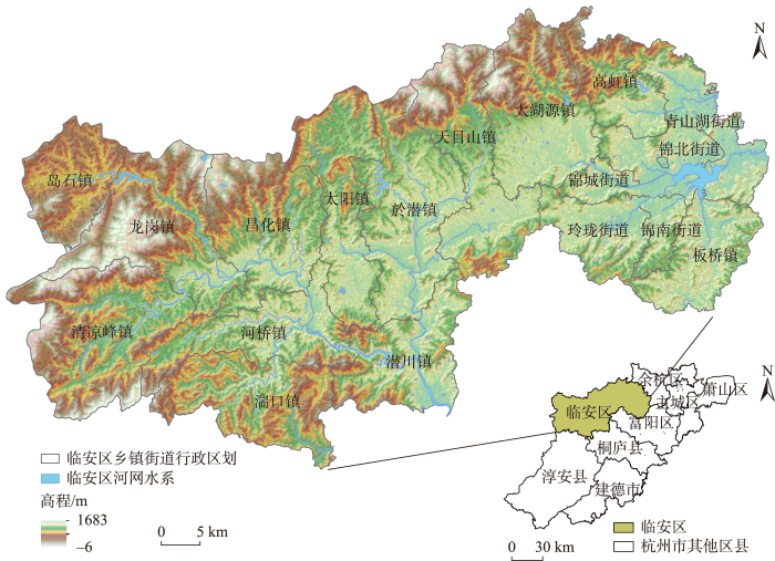
本文以临安区为案例地。临安区地处浙江省杭州市西北部(图1),位于杭州至黄山黄金旅游线路中心,生态资源丰富、历史底蕴深厚,是长三角地区重要的旅游目的地。截至2020年,临安区辖5个县级街道、13个乡镇、288个行政村,占地面积3118.77 km2,其中乡村地区面积占比近80%。截至2022年5月,临安区已有龙门秘境、红叶指南等24个村落景区与运营商签约,落地项目102个,总投资额达5.5亿元,实现旅游收入7.1亿元,村民收入增加2820万元,村集体收入增加8930万元,乡村旅游发展欣欣向荣①(①
图1
1.2 数据来源
本文所采用的数据来源如下:① 基础地理信息数据来自国家地理数据库(
2 研究过程与方法
2.1 技术路线
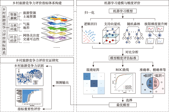
本文的技术路线如图2所示,包括指标体系构建、机器学习建模及乡村旅游竞争力评价3个部分:① 围绕资源禀赋、自然环境等角度,建立乡村旅游竞争力评价指标体系,形成指标因子数据集,并由此计算各评价单元的指标数值;② 将指标数据代入各机器学习模型进行训练,对比各模型输出的性能评估标准,从而选择最优模型;③ 利用最优模型对临安区乡村旅游竞争力进行识别评价,并输出评价指标的因子权重。
图2
2.2 乡村旅游竞争力评价指标体系构建
表1 乡村旅游竞争力评价指标体系
Tab.1
| 影响因素 | 选取指标 | 指标说明 |
|---|---|---|
| 资源禀赋 | 旅游资源指数 | 旅游资源的数量与品质是乡村旅游的核心吸引力 |
| 土地资源指数 | 不同土地利用类型,乡村旅游的发展适宜性不同 | |
| 自然环境 | 高程 | 平原、低缓地形开发难度小,乡村旅游配套设施更易布局 |
| 年平均降水量 | 影响植被生长发育与生态景观,进而影响乡村旅游的活动时间 | |
| 年平均气温 | 影响植被生长,进而影响乡村旅游的整体感知 | |
| NDVI | 有效反映乡村旅游区地表的植被覆盖状况与自然景观状况 | |
| 空气质量等级 | 反映村庄的空气质量,由PM2.5浓度按自然断点法从高到低赋值为1、2、3、4、5 | |
| 水系密度 | 水系是构成乡村旅游景观的重要元素,也能够改善环境、调节气候 | |
| 社会经济 | 路网密度 | 反映乡村旅游地的交通便利程度 |
| 交通设施数量 | 反映乡村旅游地的交通可达性状况,利用交通设施POI数量表征 | |
| 服务设施数量 | 反映乡村旅游地的配套服务水平,利用服务设施POI数量表征 | |
| 网络关注度 | 反映乡村旅游地的网络市场需求状况,利用微博签到数表征 | |
| GDP | 反映乡村旅游地的经济发展水平,是乡村旅游开发的重要条件 | |
| 政策条件指数 | 反映乡村旅游地的政府支持情况,是乡村旅游的外部环境要素 |
自然环境条件是乡村旅游发展的重要依托,良好的自然环境不仅本身就是一种生态旅游资源,而且对乡村旅游的综合体验与开发布局产生影响[46]。临安区的乡村旅游很大部分来源于生态旅游市场,对自然环境的依赖性较高,因此,本文选取了高程、年平均降水量、年平均气温、NDVI、空气质量、水系密度等指标以表征临安区乡村的自然环境状况。
2.3 数据处理
为进一步开展分析,需对数据进行预处理。首先,在ArcGIS 10.2中将指标因子数据集的坐标统一为WGS84坐标系。其次,对临安区村级行政边界内“社区”“居委会”“水库”“林地”“自然保护区”等行政单元进行剔除,只保留下288个以“村”命名的行政村单元。此后,利用分区统计、空间连接等工具计算各个村庄单元的指标数值,并使用Python工具进行Z-Score归一化处理,形成特征数据集(图3)。同时,以浙江省A级景区村等级(分为1、2、3级)作为样本标签,与特征值一同组成样本数据集。以下是部分因子的计算公式:
(1) 旅游资源指数。旅游资源指数能有效衡量地区的旅游资源总体数量与质量[44],计算公式为:
式中:
图3
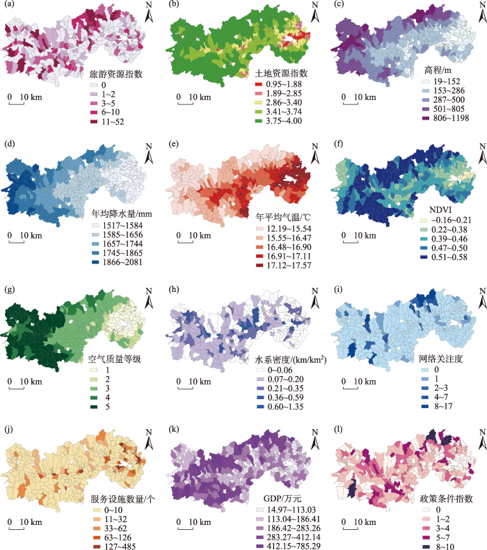
图3
乡村旅游竞争力评价指标空间分布
Fig.3
Spatial distribution of evaluation indicator values of rural tourism competitiveness
(2) 土地资源指数。不同的土地利用类型具有不同的旅游开发适宜度,将林地、草地、耕地、水域、建设用地分别赋分5、4、3、2、1,并按以下公式计算土地资源指数:
式中:
(3) 水系密度。水系密度能够表示区域河网的疏密程度,其计算公式如下:
式中:
(4) 道路密度。道路密度是评价交通可达性的重要指标。不同等级道路对交通便利的影响力不同,将高速公路、国道、省道、普通公路分别赋值为4、3、2、1,按以下公式计算道路密度:
式中:
(5) 政策条件指数。政策条件指数能够有效表征地区旅游发展的政策支持程度[45]。将国家级、省级、市级、区级的乡村旅游示范村、美丽休闲乡村等示范区称号分别赋值为4、3、2、1,并按照下列公式计算政策条件指数:
式中:
2.4 机器学习算法
2.4.1 逻辑回归(LR)
逻辑回归是一种分析因变量与自变量间回归联系的统计模型[49],在旅游适宜性评价、旅游竞争力评价等领域中应用广泛。相比于一般的回归模型,该模型的优势在于其自变量无需满足正态分布,可以是离散的,也可以是连续的。在该模型中,变量之间的相关性可被表达为:
式中:p代表事件发生的适宜性概率,在Sigmond函数曲线上[0,1]区间浮动;z值代表了自变量的线性组合。
LR的构建借助Python 3.8环境中Sklearn库的“LogisticRegression”模块。
2.4.2 支持向量机(SVM)
支持向量机是一种通过构造最优平面以解决非线性联系与高维问题的学习方法[50]。凭借坚实的统计理论基础和简明的数学模型,它在解决小样本识别问题上具有独特优势,并广泛应用于旅游需求预测、旅游潜力评价、旅游情感分析等领域。该模型最优解的目标函数L是:
式中:
利用Python 3.8环境中Sklearn库的“SVC”模块完成SVM的构建。
2.4.3 随机森林(RF)
随机森林是一种以决策树为基分类器的Bagging集成学习算法[51],该方法已在旅游偏好预测、旅游用地适宜性评价等领域取得了较好的研究成果。该模型包含多棵决策树子模型,模型的分类结果由各棵决策树的分类结果所决定,因此,它具有较高的稳定性与扩展性。
该模型的基础公式为:
式中:
在Python 3.8平台中利用Sklearn库的“RandomForestClassifier”模块实现RF的构建。
2.4.4 极端梯度提升树(XGB)
极端梯度提升树是一种基于弱分类器迭代运算的Boosting集成学习模型[52],自2017年提出以来,XGB以其高准确度、高可扩展性的优势,在旅游目的地形象评价、旅游流量趋势预测等领域得到广泛应用。其弱分类器兼具树模型和线性模型,且能够利用中央处理器进行复杂的多线程并行运算,从而提升了模型预测精度、稳定性与计算效率。该模型的目标函数O的计算公式是:
式中:i表示第i个样本,q代表导入第k棵树的样本总量,
XGB在Python 3.8环境中利用Xgboost库的“XGBClassifier”模块构建。
2.5 模型精度评价标准
本文采用混淆矩阵(confusion matrix)、精确率(accuracy)、准确率(precision)、召回率(recall)、F1得分(F1-score)、ROC曲线(receiver operating characteristic curve)共6项模型评估指标进行机器学习预测性能的比较分析。其中,混淆矩阵能够可视化呈现算法的精度,其每一行代表样本的真实类别,每一列代表样本的预测类别。基于混淆矩阵,精确率、准确率、召回率及F1得分分别从不同角度量化了模型预测值与标签真实值的接近程度,值越高,模型精度越高。ROC曲线以样本伪阳性率为X坐标,以样本真阳性率为Y坐标,与坐标轴形成的图形面积为AUC值,值越大,模型性能越好。由于本文训练样本存在一定类别不均衡问题,故采用宏平均(macro-average)方法计算准确率、精确率、召回率、F1得分:
式中:macroA、macroP、macroR、macroF1分别代表按宏平均计算的准确率、精确率、召回率与F1得分,
3 结果分析
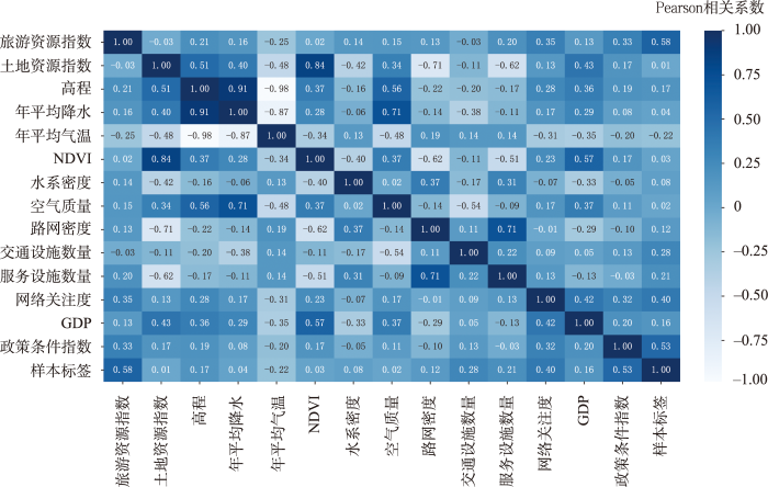
3.1 变量相关性分析
对样本数据集的相关性分析显示:特征数据集与样本标签值的Pearson相关系数多在0.3及以上,而特征间的相关系数多在0.1以下(图4),这说明各评价因子与乡村旅游竞争力水平之间存在一定相关性,且各评价因子间的信息重叠率较低,指标体系对旅游竞争力评价而言具有特征标识意义。
图4
3.2 模型评价精度对比
将数据集按7∶3比例划分为训练集与测试集。其中,训练集用于各个机器学习模型的创建与训练,并采用贝叶斯优化进行模型的超参数调优。测试集用于各模型的模型精度评价,按照宏平均的计算方法,输出各个模型的混淆矩阵(图5),精确度、准确率、召回率、F1得分(表2)与ROC曲线(图6)。在各模型的精度评价结果中,准确率的最高值是RF的预测(0.820),其次是XGB(0.803),而LR与SVM的预测出现了准确率的最低值(0.770);精确率的数值范围是0.775~0.819,最高值与最低值分别是RF与LR的预测;RF的召回率最高,为0.820,而LR和SVM的召回率最低,为0.770;F1得分最高的是RF(0.819),其次是XGB(0.804),最低值是SVM(0.766);AUC值的变化范围是0.930~0.939,其中RF的AUC值最接近于1,为0.939,而LR与SVM的AUC值最低,为0.930。
图5
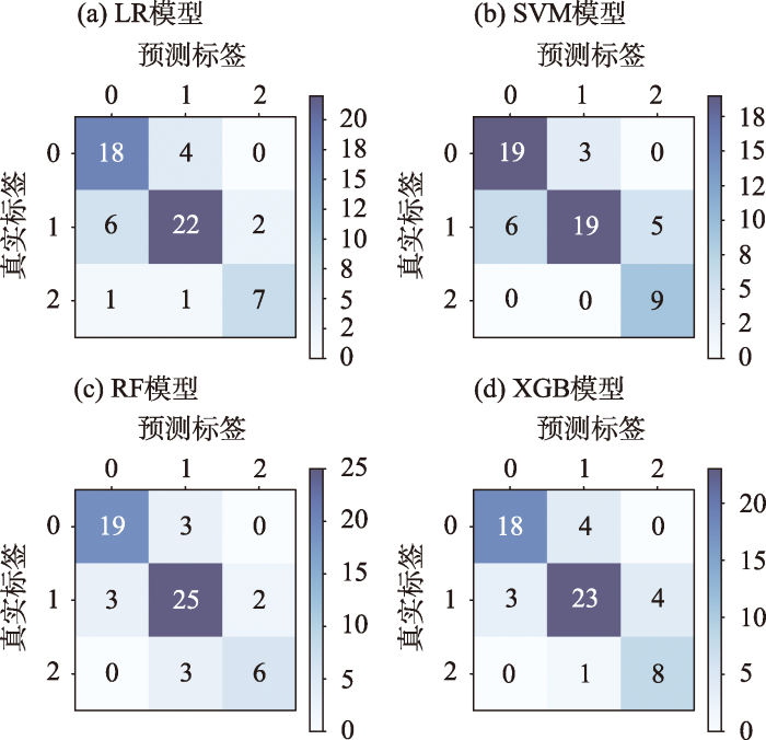
表2 各模型精度评估指标结果
Tab.2
| 模型 | 准确率 | 精确率 | 召回率 | F1得分 |
|---|---|---|---|---|
| LR | 0.770 | 0.775 | 0.770 | 0.771 |
| SVM | 0.770 | 0.794 | 0.770 | 0.766 |
| RF | 0.820 | 0.819 | 0.820 | 0.819 |
| XGB | 0.803 | 0.811 | 0.803 | 0.804 |
图6
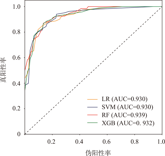
综合各个精度评价标准,4种机器学习模型的评价精度整体较好,其中两种非线性集成学习模型(RF、XGB)对乡村旅游竞争力的识别精度相对更高,线性模型LR、SVM(线性核)模型的识别精度相对较低。RF的识别性能相比其他3个模型要更优,是本文乡村旅游竞争力评价的最优模型,故进一步利用RF进行评价指标重要性分析与乡村旅游竞争力评价。
3.3 指标因子重要性评价
通过分析RF的指标因子重要性排序(图7),旅游资源的重要性值最高(0.171),服务设施(0.116)、路网密度(0.091)、政策条件(0.090)的重要性也相对较高,其次是交通设施(0.075)、空气质量(0.060)、 NDVI(0.058)、年平均气温(0.056)、高程(0.054)、网络关注度(0.051)和GDP(0.051);而年平均降水量(0.050)、土地资源禀赋(0.047)和水系密度(0.030)的特征重要性相对较低。由此可见,影响乡村旅游竞争力评价的核心指标主要是旅游资源、服务设施、路网密度以及政策条件。其中,旅游资源作为乡村旅游目的地的第一生产要素,对游客产生最为直接的旅游吸引力,是最重要的指标因子之一。餐饮、住宿等服务设施以及完善的交通设施能够有效提高乡村旅游目的地的接待能力,为乡村旅游目的地输送充足的客源。临安区村落景区的开发运营,也得益于地方政府在战略规划、财政政策等方面的支持。同时,空气质量、NDVI、年平均气温、网络关注度等指标因子在评价过程中也占据重要地位,这与临安区乡村旅游“森林氧吧、夏季避暑”的主题特色有关,较高的植被覆盖率、适宜的年平均气温、良好的空气质量,是打造乡村旅游避暑胜地的基础。互联网是当代旅游目的地进行品牌宣传的重要手段,较高的网络关注度能为乡村旅游地输送更多慕名而来的游客。另外,土地资源禀赋、水系密度、年平均降水等指标在特征重要性中排名靠后,对乡村旅游竞争力的贡献相对较小。
图7
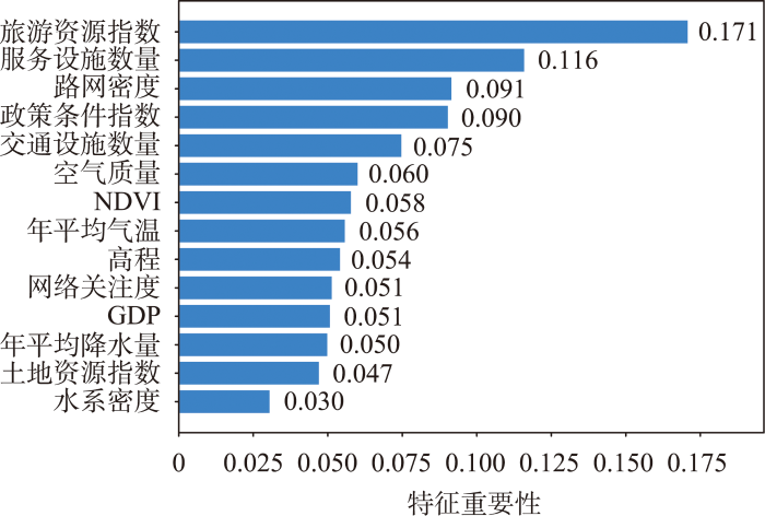
图7
指标因子对乡村旅游竞争力评价的相对重要程度
Fig.7
Relative importance of the indicators in the evaluation of rural tourism competitiveness
3.4 乡村旅游竞争力特征识别结果
图8
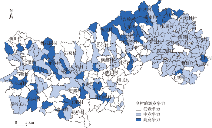
图8
基于随机森林模型的乡村旅游竞争力识别结果
注:为理解方便,图中只标注了提及的村庄和面积较大的村庄。
Fig.8
Identification results of rural tourism competitiveness based on the random forest model
图9
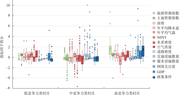
图9
不同竞争力等级村庄的指标因子得分箱型图
Fig.9
Box plot of indicator scores of the three rural tourism competitiveness categories
中竞争力类村庄包括了花戏村、龙马村、云浪村、后营村等150个村庄,主要以团块状分布在东部城镇近郊区、中部河谷区和西部山地地区,涵盖了瑞晶石花洞、昱岭关等旅游景区。由图9可知,这类村庄的政策支持条件和交通条件在临安区内位居前列,但是其旅游资源的数量与质量相比高竞争力村庄较低,且在服务设施、网络关注度等方面不具优势。在未来发展过程中,应根据村庄的开发潜力,择优进行乡村旅游目的地打造,并采取服务设施完善、网络媒体运营等针对性优化措施。
低竞争力类村庄主要以斑块状分布于中西部地区,包括黄川村、洪岭村、马啸村、后葛村等93个村落。图9表明,该类村庄的生态环境与土地资源禀赋颇具潜力,但是缺少相关的旅游产业开发,旅游资源的数量品质与高、中竞争力类村庄差距较大,且在交通可达性、服务完善度、网络关注度等方面也存在着明显短板,崎岖的地形条件更是制约了乡村旅游的发展。此类村庄应充分发挥生态环境的优势,在政府的规划指导下,采取多种手段引进社会资本,改善旅游发展条件,进行生态旅游开发。
4 结论与讨论
本文以杭州市临安区为例,基于多源遥感和互联网数据,从社会经济、自然环境、资源禀赋3个维度建立了乡村旅游竞争力评价指标体系,对比了LR、SVM、RF、XGB四种机器学习算法在乡村旅游竞争力评价中的性能,并选取最优算法RF以揭示临安区村域尺度的乡村旅游竞争力格局,主要结论如下:
(1) 以随机森林为代表的机器学习算法能够有效支撑乡村旅游竞争力的评价识别。从评价精度而言,4种机器学习算法的表现整体较好,非线性模型RF、XGB要优于线性模型LR、SVM(线性核)。这与既有研究[53]和本文预期相符,RF、XGB作为非线性的集成学习模型,能够较好地处理变量间复杂的非线性联系,予以更为客观的因子权重,从而相比于仅能处理变量间线性联系的线性模型LR、SVM(线性核),能够在乡村旅游竞争力评价过程中具有更好的预测表现。在2种集成学习模型中,RF比XGB的评价表现更加稳定,是研究区乡村旅游竞争力评价的最优模型。金昭等[54]对比了SVM、RF等9种模型在土壤重金属空间的预测精度,发现RF的表现最优;赵雨等[55]对比了LR、SVM、RF、XGB等6种算法在贫困地识别的预测精度,发现RF的预测结果更加精准。在本文中,XGB对乡村旅游竞争力预测的准确率、精确率、召回率等指标均低于RF,总体的预测性能劣于RF。相反,Zhou等[39]通过对比XGB、RF、LR、SVM在滑坡敏感性评估的表现,发现XGB模型的评估效果优于RF等模型。一般来说,RF模型的参数调整过程较为简单,对数据噪声和异常值具有较高的容忍度,能够有效避免过拟合问题,相比其余模型通常会具有更好的评估表现。然而,对于XGB这类复杂度较高的模型而言,在本文中样本体量较少、类型分布较不平衡的情况下,容易出现过拟合的现象,如果能进行更为细致的调参,XGB或许能够具备比RF更优的评估表现。
(2) RF的特征重要性排序显示,旅游资源禀赋、服务设施数量、交通可达性、政策条件是影响乡村旅游竞争力的首要因素。旅游资源作为乡村旅游竞争力的核心驱动力,对乡村旅游竞争力具有非常重要的影响。配套设施水平影响了游客在乡村旅游地的综合体验,是乡村旅游竞争力的内在因素。乡村旅游的政策支持情况,也会从外部环境上影响资源的开发利用与设施的建设情况。该发现佐证了Crouch等[14]、Dwyer等[15]对于旅游资源重要性的肯定,也回应了Jia等[45]“旅游资源、支持产业、政策支持对乡村旅游竞争力具有重要影响”的观点。相反,赵伟等[21]、郭焕成等[56]基于旅游业的发展规律,认为经济水平、市场条件对乡村旅游竞争力的重要性高于资源禀赋、政策支持等要素的地位。这可能与案例地旅游发展的实际情况有关。杨世河等[7]提出,不同发展类型的乡村旅游目的地的影响因素不同,城市依托型和交通依托型目的地偏向于市场、经济水平驱动,而资源依托型和景区依托型偏向于资源驱动型。临安区目前的乡村旅游目的地,主要依托丰富的自然、人文旅游资源而得到发展,以资源依托型、景区依托型为主,其发展水平受资源的影响更大。此外,乡村与城市之间重要的区别因素是独特的自然环境,RF的因子重要性排序也显示了空气质量、NDVI、年平均气温等自然环境要素的重要性,这也回应了Roman等[57]的观点,证明了自然环境对乡村旅游竞争力的重要影响。
(3) RF的乡村旅游竞争力空间识别结果表明:高竞争力村庄以条带状形式分布在临安区北部天目山、西部昱岭山区,在社会经济、自然环境、资源禀赋等各方面具有较优越的条件。中竞争力村庄以团块状形式分布在临安区东部城镇近郊区、中西部地区,整体的资源禀赋和配套设施水平与高竞争力村庄有一定差距。低竞争力村庄以斑块状形式分布在中、西部地区,普遍处于生态环境优越、土地资源禀赋较好的山区,但是由于地形的阻隔,缺乏旅游资源与配套设施的开发建设。
此外,本文也存在一些不足之处。由于数据来源的限制,关于村庄旅游收入水平、旅游企业管理、社会文化、社区支持等方面欠缺考虑,有待今后补充相关数据,完善现有评价指标体系。同时,部分指标因子与旅游竞争力之间的联系具有地理空间相对性,例如对整体平坦的地区和整体崎岖的地区,地形要素对于旅游竞争力的影响程度不同,但本文没有考虑指标要素在局部地理空间上的相对性,有待后续研究在地理加权回归方面进行深入探讨。同时,机器学习的可解释性问题有待进一步讨论,未来研究可以考虑结合SHAP等可解释机器学习模型,对乡村旅游竞争力的影响机制进行更细致的分析。
尽管如此,本文提出了一套结合机器学习和多源数据对乡村旅游竞争力进行定量评价的方法,利用客观准确的机器学习技术,充分挖掘多源互联网与遥感数据中的丰富信息,能够有效避免传统方法存在的主观性,对村域尺度的乡村旅游竞争力进行更为科学细致的评价,为今后旅游竞争力相关研究提供了新颖的方法借鉴与视角参考。此外,利用定量化手段评价区域乡村旅游竞争力并进行优劣势分析,可以为数字化赋能乡村发展规划提供技术支持,有助于乡村找准自身定位参与竞争合作,对区域优化乡村旅游空间布局、建立可持续的乡村旅游发展模式,具有重要的实践意义。
参考文献
中共中央办公厅国务院办公厅印发《关于加大脱贫攻坚力度支持革命老区开发建设的指导意见》
[J].
Several views of the Central Committee of the Communist Party of China State Council on implementing the development of new concept, accelerating the modernization of agriculture, and realizing the goal of comprehensive well-off
旅游驱动下乡村转型发展的微尺度研究: 以西安市上王村为例
[J].
DOI:10.18306/dlkxjz.2020.06.014
[本文引用: 1]

基于多要素综合视角,论文从土地与生计2个维度构建微观尺度的乡村地域系统概念模型;融合遥感影像数据、问卷调查数据及访谈资料等多源数据,以西安市上王村为例,探究“城郊村”在旅游驱动下的土地利用和农户生计转型,并对其与“景边村”的转型发展进行案例较析。结果表明:① 伴随乡村旅游发展的规模化和专业化,上王村的土地利用日益多样化、复合化、旅游化,农户生计方式组合渐进更替,家庭就业、收入、消费与旅游的相关性不断提高,由传统农业村转型为乡村旅游目的地。② 上王村的转型发展是内外部因素综合作用的结果,优越的区位条件是其前提和基础,政府的适时调控是“稳定器”和“方向盘”,乡村旅游客源市场的壮大和农户的理性选择是外源拉动力和内在驱动力。③ “城郊村”和“景边村”因区位不同而在地形条件、依托资源、客源市场等方面存在差异,引致两者乡村旅游开发的分化,同时深刻影响了各自的转型发展进程。
Micro-scale study on rural transformation and development driven by tourism: Taking Shangwang Village in Xi'an City as an example
DOI:10.18306/dlkxjz.2020.06.014
[本文引用: 1]
Based on a multi-factor comprehensive perspective, a conceptual model of micro-scale rural regional system was constructed with land use and livelihood dimensions. Taking Shangwang Village in Xi'an City as an example, and using remote sensing images, survey questionnaires, and interview data, this study explored the transformation of land use and the livelihood change of farmers in a "suburban village". On this basis, four "scenery-surrounding villages" with different location characteristics and development types were compared and analyzed, and the following conclusions were obtained: 1) With the scaling-up and specialization of rural tourism development, the land use of Shangwang Village has gradually become diversified, compounded, and tourism-focused. The combination of farmers' livelihood strategies begin to change, and the correlation between employment, income, consumption, and tourism continues to increase. Shangwang Village has been transformed from a traditional agricultural village to a destination for rural tourism. 2) The transformation and development of Shangwang Village is the result of the comprehensive effect of internal and external factors. Its superior location is the basis of the transformation and development, and the timely intervention and regulation of the government is an important support. The development of the tourist market of rural tourism is its external driving force, and the rational choice of farmers is its internal driving force. 3) The differences between the "suburban village" and the "scenery-surrounding villages" in terms of terrain condition, resources endowment, and tourist market due to their different locations have led to the differentiation of the rural tourism development and have affected their transformation and development processes.
新型城镇化背景下的乡村旅游发展: 理论反思与困境突破
[J].
DOI:10.11821/dlyj201508001
[本文引用: 1]
新型城镇化在为乡村旅游发展带来重大机遇的同时也带来了新的要求和挑战。大力发展乡村旅游,科学引导乡村地域城镇化,是中国新型城镇化和乡村经济社会发展的重大现实需求和重要科学命题。通过对新型城镇化背景下乡村旅游的审视和反思,认为乡村旅游既面临环境质量下降、乡村文化受损、旅游同质竞争、整体品质不高、产业培育不足、资金人才短缺、运营模式落后、土地利用错位等现实困境,又面临着新形势下需深入研究的诸多复杂性理论问题。提出要响应新时期国家重大战略和乡村旅游的发展需求,重点关注新型城镇化背景下的乡村旅游特性、新型城镇化对乡村旅游的影响与互动机制、旅游引导的新型城镇化发展模式、乡村旅游文化与乡愁记忆的恢复与重构、乡村生态文明与乡村旅游的融合发展、乡村旅游空间结构优化及城乡旅游一体化空间格局与机制、乡村旅游产品开发与产业融合创新、乡村旅游社区参与及“三农”问题解决路径、乡村旅游运营管理与政策制度创新等科学问题。通过深化理论研究和强化实践应用,推动乡村旅游提质增效升级,引导具备条件的乡村走以旅游为导向的中国特色新型城镇化道路,实现城乡旅游互补和协调发展。
Research and development of rural tourism under the background of new urbanization: Theoretical reflection and breakthrough of predicament
DOI:10.11821/dlyj201508001
[本文引用: 1]
The great opportunity of the development of rural tourism appears for new urbanization. Meanwhile, new demands and challenges are emerging. It is the rapid development of rural tourism and the scientific guidance of urbanization of rural areas that generate the significant and practical demand as well as the important and scientific proposition of new urbanization and the development of rural economy and society of China. By reviewing and rethinking rural tourism under the background of new urbanization, the realistic predicament of rural tourism is revealed such as environmental degradation, damage of rural culture, homogeneous competition of tourism, the low level quality overall, inadequate industrial training, shortage of fund and talent, lagging operation model, dislocation of land use, etc., at the same time, the in-depth study is required to solve many theoretic problems of complexity under the new situation. The paper proposes some suggestions, for example, the response to the demand of the major national strategy and the development of rural tourism in the new period should focus on some scientific problems including the features of rural tourism under the background of new urbanization, the influence and interaction mechanism of new urbanization on rural tourism, tourism led development mode of new urbanization, the recovery and reconstruction of rural tourism culture and nostalgic memory, the development of integration between rural ecological civilization and rural tourism, the spatial optimization of rural tourism as well as the spatial pattern and mechanism of the integration of urban and rural tourism, the product development of rural tourism and industrial integration and innovation, the solution to community participation in 'three rural issues' of rural tourism, the operation and management of rural tourism and the innovation of policies and institutions, etc. By deepening the theoretic research and strengthening the practical application, on the one hand, the upgrade of quality and efficiency of rural tourism can be improved, on the other hand, some qualified villages can be directed to the tourism-oriented road of new urbanization with Chinese characteristics. Finally, the complementary and coordinated development between urban and rural tourism can be achieved.
1992—2016年中国乡村旅游研究特征与趋势: 基于CiteSpace知识图谱分析
[J].
DOI:10.18306/dlkxjz.2018.09.003
[本文引用: 1]
借助 CiteSpace软件,选取CNKI中国学术期刊网络出版总库的中文核心期刊和CSSCI来源期刊,对1992-2016年间中国乡村旅游研究文献分析发现:虽然乡村旅游研究文献众多,但尚未形成紧密的学术团队,学者相互认可度较低;研究机构学术合作网络较为松散。在时间序列上,25年来中国乡村旅游研究可划分为萌芽阶段(1992-1998年)、初步多元化阶段(1999-2005年)、快速多元化阶段(2006-2012年)和深入研究阶段(2013年-)。在研究内容上,政策导向性明显,研究主题紧跟国家政策变化呈现多样性;经济视角是主线,发展对策、模式类研究成果较多;生态理念贯穿始终,学界对乡村生态旅游一直较为重视。整体来说,学科研究呈现经济学、社会学、地理学、农学等多学科参与的特征;研究价值诉求从以消费者为主逐步转向社区居民,全面人文关怀凸显;最近几年,学者结合现实问题对乡村旅游发展及研究反思增多。今后,从问题出发开展多学科、多技术和多机构合作,对乡村旅游存在的哲学基础和基本理论,产业转型升级及土地利用等现实问题,新型城市化背景下的乡村旅游地社会空间问题以及多样化发展的对策探索等方面的研究将成为重点。
Characteristics and prospects of Chinese rural tourism research,1992-2016: An analysis based on CiteSpace maps
DOI:10.18306/dlkxjz.2018.09.003
[本文引用: 1]
Based on research articles selected from the core journals and the Chinese Social Sciences Citation Index (CSSCI) journals in the China National Knowledge Infrastructure (CNKI) academic journal network publishing database and with the help of CiteSpace software, this study analyzed the authors, cooperative institutions, and keywords on China's rural tourism research literature published between 1992 and 2016 and found that China's rural tourism research has not formed close research teams and scholars have low recognition of each other's work. Research cooperation networks are loosely organized between academic institutions. The whole process of research can be divided into four stages: emerging stage (1992-1998), preliminary diversification stage (1999-2005), rapid diversification stage (2006-2012), and in-depth study stage (2013-present). With regard to the research contents, policy guidance is clear—the research topics closely followed the national policy change and showed diversity. The research focused on the economics of tourism from the beginning and there exists a large number of research articles on development strategies and models. The researchers have been insisting on ecological ideas all the time. Overall, economics, sociology, geography, agronomy, and many other disciplines have been involved in this field. The main value proposition changed from the consumer to the whole population, showing the trend of comprehensive humanistic care in rural tourism research. Moreover, in recent years, the researchers have introspected and actively exercised the discourse power to participate in the real business of rural tourism. According to the actual situation of development of rural tourism in China and its research characteristics, multidisciplinary, multi-technological, and multi-organizational studies will be carried out in view of rural tourism problems and more research on the philosophical foundation, basic concepts, and basic theories of rural tourism, transformation and upgrading of rural tourism, land use in the development of rural tourism, social and spatial questions of rural tourism in the context of the new urbanization in China, and development strategies of rural tourism diversity will become the key points of future research.
美丽乡村背景下河南乡村旅游发展问题与对策
[J].
Problems and countermeasures of rural tourism development in Henan Province on beautiful village background
乡村旅游高质量发展: 内涵特征、关键问题及对策建议
[J].
The high-quality development of rural tourism: Connotative features, key issues and countermeasures
基于类型的乡村旅游竞争力研究
[J].
Study on competitiveness of village traveling place in view of type
全球贫困国家旅游竞争力与经济发展的耦合协调度及时空变化
[J].
DOI:10.18306/dlkxjz.2018.10.008
[本文引用: 1]
基于联合国多维贫困指数、世界经济论坛旅游竞争力报告及国际货币基金组织提供的贫困国家经济数据,构建了旅游竞争力与经济发展评价指标体系,通过信息熵值法确定指标权重,再运用耦合协调度模型测度2008-2017年间贫困国家旅游竞争力与经济发展之间的耦合协调度,研究其时空演变规律及成因机制。研究发现:①贫困国家旅游竞争力与经济发展的的耦合协调现状不容乐观,基本都处于失调或接近失调状态,但从时间发展来看,有向协调方向缓慢发展的趋势,且耦合协调度的区域差异正在缓慢缩小;②从耦合协调类型上看,大部分贫困国家为经济滞后型,其余为旅游—经济同步型,尚无旅游滞后型;③贫困国家旅游竞争力与经济发展的耦合协调度等级分布呈现较明显的空间集聚特征,非洲地区耦合协调度等级相对最低,南美洲及加勒比地区耦合协调状态相对较好,东南亚地区则呈现局部异质性。
Coupling coordination between tourism competitiveness and economic development in global poverty-stricken countries and spatiotemporal changes
DOI:10.18306/dlkxjz.2018.10.008
[本文引用: 1]
With the increasing importance of tourism industry in the global economic development, tourism has become a significant growth point for poor countries. To strengthen the understanding of the actual state of coupling and coordination between tourism competitiveness and economic development in these countries, and to further understand the development of the coupling coordination degree and regional differences between tourism and economy development in poor countries around the world, we conducted the study of this article. First, based on the multidimensional poverty index of the United Nations, the World Economic Forum's tourism competitiveness report, and the per capita GDP data of the poor countries provided by International Monetary Fund, an evaluation index system of tourism competitiveness and economic development was constructed. Next, we calculated the weights and comprehensive evaluation index values through the information entropy method, and then used the coupling coordination model to measure the coupling coordination degree between tourism competitiveness and economic development in global poverty-stricken countries during 2008-2017, and clarified its spatiotemporal evolution to explore the genesis mechanism. On case selection, this study first ranked the Travel and Tourism Competitiveness Report (TTCR)'s 141 economies in 2015 according to the multidimensional poverty index of the Human Development Report 2015. Then countries that lack tourism competitiveness indices such as Niger, South Sudan, and Somalia were eliminated. Only 35 poverty-stricken countries with high poverty index rankings and complete data on tourism competitiveness were reserved for our research. The study area mainly focused on Africa, Asia, South America, and the Caribbean, and the specific years of research are 2008, 2009, 2011, 2013, 2015, and 2017. The results indicate that: (1) There is a high correlation between tourism competitiveness and economic development in poor countries and the current situation of coupling coordination is not optimistic, as most poor countries are in a state of imbalance or near mismatch. However, there is a tendency toward the coordinated direction, and regional differences in coupling coordination among these countries are slowly shrinking; (2) The coupling coordination between the two can be divided into four levels and two types of constraints. Most of the poor countries are economically lagging. The rest of them are tourism-economy synchronous, and no poor countries are tourism competitiveness lagging; (3) The hierarchical distribution of the coupling coordination in poor countries shows clear spatial clustering characteristics. The level of coupling coordination in Africa is relatively low. The coupling coordination status is relatively good in South America and the Caribbean, and Southeast Asia shows partial heterogeneity. In general, this research is based on the coupled relationship between tourism competitiveness and economic development in poor countries. It can provide a decision-making basis for future economic structural adjustment and tourism industry development in these countries, and provide references for other countries around the world. At the same time, this article responds positively to the tourism poverty alleviation policies that China strongly advocates, and provides theoretical support for the country's economic cooperation and tourism poverty reduction practices along the "Belt and Road" route.
省域城市旅游竞争力测度与评价: 以湖南省为例
[J].
Measurement and evaluation of tourism competitiveness of provincial city: A case study of Hunan Province
DOI:10.2307/142404 URL [本文引用: 1]
全域旅游视角下环洞庭湖城市旅游竞争力及区域合作
[J].
Tourism competitiveness and regional tourism cooperation around Dongting Lake from the whole domain tourism
国家旅游竞争力与游客感知的关系研究: 以旅华欧美游客为例
[J].
The relationship between the national tourism competitiveness and tourist perceptive
基于生态位理论的山东省城市旅游竞争力评价及空间格局研究
[J].
Evaluation and spatial pattern of urban tourism competitiveness in Shandong Province based on ecological niche theory
中国省域森林公园旅游产业竞争力的时空演化特征及影响因素
[J].
Study on the spatio-temporal characteristics and the influential factors of the competitiveness of tourism industry in provincial forest park of China
Tourism, competitiveness, and societal prosperity
[J].DOI:10.1016/S0148-2963(97)00196-3 URL [本文引用: 2]
Destination competitiveness: Determinants and indicators
[J].DOI:10.1080/13683500308667962 URL [本文引用: 2]
山东省乡村旅游竞争力评价与障碍因素分析
[J].
DOI:10.13249/j.cnki.sgs.2019.01.017
[本文引用: 2]
以山东省17地市为研究对象,构建乡村旅游竞争力主要指标评价体系,运用熵权TOPSIS法进行比较排序,并进行障碍度分析,发现:山东省17地市乡村旅游发展不平衡,烟台市乡村旅游竞争力最高,东营、菏泽、德州、聊城的竞争力较低;各地市竞争力水平空间分布具有差异性,半岛沿海地区乡村旅游竞争力较高,鲁西及鲁北地区竞争力较低;乡村旅游接待与服务能力是制约大部分地市乡村旅游竞争力提升的第一障碍因素,资源禀赋、自然环境、经济基础及客源市场条件在不同程度上制约各地市乡村旅游竞争力的提高。各地市应采取针对性的措施解决乡村旅游发展的障碍因素,推动乡村旅游合理有序发展。
Analysis of rural tourism competitiveness and obstacle factors in Shandong Province
DOI:10.13249/j.cnki.sgs.2019.01.017
[本文引用: 2]
Rural tourism is a new kind of industries in rural areas. It is of great significance to increase farmers' income, promote the adjustment of rural industrial structure, achieve poverty alleviation, realizes the country revitalization etc. The rapid development of rural tourism has brought a series of problems, such as vicious competition, similar products, environmental pollution. Taking 17 cities of Shandong Province as the research object, this article evaluates the competitiveness of rural tourism rural tourism development level and analyzes the degree of obstacles to make suggestion on the development of rural tourism in this region. Based on the theoretical analysis of the development of the rural tourism, this article constructs the main index evaluation system of rural tourism competitiveness. The evaluation system mainly includes rural tourism resources conditions, environment condition, economic conditions, social conditions and the tourist marketing conditions, which consists of a total 12 factors. The TOPSIS method is used to measure the level of rural tourism competitiveness. Then reveal the factors that hinder the improvement of the competitiveness of rural tourism in this region by using the Obstacle Degree Model (calculating factor contribution, index deviation and obstacle respectively). First, the development level of rural tourism in 17 cities is not balanced. Among them, the highest scores of 0.582 8, the lowest was 0.175 0. The competitiveness of Yantai is the highest, while the competitiveness of Heze, Dongying, Dezhou and Liaocheng is the lowest. Second, there are differences in the competitiveness of cities in the regions. The competitiveness of rural tourism in the eastern is high, with Low competitiveness in the western and northern areas of Shandong Province. Third, the Obstacle Degree Model results show that the tourist reception capacity is the common factors that hinder the improvement of the competitiveness of rural tourism in Shandong Province. Furthermore, the obstacle factors are different between cities. All localities and municipalities in Shandong Province should make efforts to solve the restrictive factors of enhancing the competitiveness of rural tourism and realize the rational and orderly development of rural tourism. Each city should continuously optimize the industrial structure, improve the economic development level, rationally and effectively improve the proportion of the tourism industry in GDP. Government should give full play to the level and ability of the financial and public services, increase the investment in rural tourism infrastructure. In particular, government should guide and rationally support the creation of star farm, improve the reception capacity of rural tourism and solve the biggest obstacle to the development of rural tourism.
Rural tourism destination competitiveness: A study on Annah Rais Longhouse Homestay, Sarawak
[J].DOI:10.1016/j.sbspro.2014.07.271 URL [本文引用: 1]
县域乡村旅游竞争力评价指标体系构建及类型区划研究: 以烟台市12个县域单元为例
[J].
The establishment of evaluation system for the county rural tourism competitiveness and analysis of region variance: A case study of 12 counties in Yantai
福建省乡村旅游产业潜力和竞争力分析研究
[J].
Analysis on the potential and competitiveness of rural tourism industry in Fujian Province
苏州乡村旅游竞争力研究
[J].
A study on competitiveness of Suzhou rural tourism
福建省县域乡村旅游竞争力评价
[J].
Research on county rural tourism competitive ability in Fujian Province
基于竞争力评价的区域旅游产业发展差异: 以中国东部沿海三大旅游圈为例
[J].
Differences of regional tourism development based on competitiveness evaluation: A case study of the three circles in eastern coastal China
DOI:10.11820/dlkxjz.2011.02.015
[本文引用: 1]
Using analytic hierarchy process (AHP) and cluster analysis and establishing a three-level indicator system of regional tourism competitiveness, this paper measures and analyses tourism competitiveness in the three circles economic in eastern coastal region of China. By measuring the differences of tourism competitiveness from the angle of I (O) coefficient, the study reveals the differences of tourism development among the provinces and the three circles in eastern coastal China using 9 secondary indicators, and recognizes the spatial disparity of tourism competitiveness in eastern coastal China, and on the basis of which, tentative countermeasures for implanting and upgrading regional tourism competitiveness are put forward.
海南省乡村旅游资源可持续发展评价指标体系构建
[J].
Analysis of sustainable development of rural tourism resources system in Hainan
基于POI数据的山西省旅游景区分类及空间分布特征
[J].
DOI:10.13249/j.cnki.sgs.2021.07.015
[本文引用: 1]
运用大数据与传统地理信息系统相结合的方式,以山西旅游景区POI(Point of Interest)数据为研究对象,对其进行分类后,研究其总体空间分布格局、分布方向以及具体地市空间分布特征。结果表明:山西旅游景区总体分布格局呈现晋中地区集聚特征,具体各类旅游景区的集聚形态与程度有所差异。其中,地文景观类旅游景区集聚于晋中、晋东南和晋北东部地区;水域风光类旅游景区以晋中、晋南和晋北东部地区为轴呈条带状分布;生物景观类旅游景区在空间上呈“菱形”状集聚形态;遗址遗迹类旅游景区集聚于晋北和晋东南地区;建筑与设施类旅游景区呈“三角形”状集聚特征;娱乐购物类旅游景区在全省范围内分布较为均匀。旅游景区空间分布方向与山西省区域形状吻合,除娱乐购物类旅游景区分布方向性和向心性不明显之外,其他类别旅游景区均有不同程度的集聚特征;各地市旅游景区分布情况中,水域风光类旅游景区在各市域间分布较为均匀,地文景观类和建筑设施类旅游景区热点区域出现在阳泉市,冷点区域出现在晋城市,但其集聚程度均较低;生物景观类旅游景区热点区域位于长治市,冷点区域位于临汾市和运城市,其集聚程度较高。最后,从自然地理和人文社会两方面对旅游景区空间分布的影响因素进行了定性分析。
Classification and spatial distribution characteristics of tourist attractions in Shanxi Province based on POI data
DOI:10.13249/j.cnki.sgs.2021.07.015
[本文引用: 1]
By combining big data with traditional geographic information system and taking Point of Interest (POI) data of Shanxi tourist attractions as the research object, we firstly classified the data, and then analyzed their overall spatial distribution pattern and distribution direction, as well as their spatial distribution characteristics of specific cities. Results showed that the overall distribution pattern of tourist scenic spots in Shanxi presents an agglomeration characteristic in Jinzhong district, but the agglomeration pattern and degree of the tourist scenic spots in different district were different. Geographical landscape tourist attractions mainly concentrated in central, southeast and northeast districts of Shanxi. Water scenic spots concentrated in central, south and northeast districts with an axial zonal distribution; Biological landscape tourist attractions showed a ‘diamond’ agglomeration pattern; relics tourist attractions were mostly distributed in northern, and southeastern Shanxi; Construction and facilities of tourist attractions presented agglomeration characteristics of triangular shape; The entertainment and shopping tourist attractions were evenly distributed in the whole province. The spatial distribution direction of tourist scenic spots was consistent with the regional shape of Shanxi Province. Except for no directionality and centrality of the distribution of entertainment and shopping tourist scenic spots were found, other types of the tourist scenic spots have different degree of agglomeration characteristics. The analysis of the spatial pattern of tourist attractions for all prefecture-level cities showed that water scenery scenic spots were evenly distributed among the cities. The hot spots of landscape and architectural facilities appeared in Yangquan City, while the cold spots appeared in Jincheng City, but the degree of agglomeration was small. The hot spot area of biological landscape tourist attractions is located in Changzhi City, while the cold spot area is located in Linfen City and Yuncheng City, with a high degree of agglomeration. In addition, the factors that influence the spatial distribution of scenic spots were qualitatively analyzed from two aspects of physical geography and human society.
微博签到大数据中旅游景区客流波动特征分析: 以南京市钟山风景名胜区为例
[J].
Characteristics of tourists flow in scenic spots based on Weibo check-in big data: A case study of Zhongshan scenic spot in Nanjing City
基于多源数据的城市功能区精细化研究: 以北京为例
[J].
DOI:10.11821/dlyj020200074
[本文引用: 1]
城市功能分区研究在时空尺度上不断细化,多源数据融合有利于推动城市功能分区研究的精细化发展。本文对比国内外城市功能区研究中对多种新型地理数据的内涵挖掘和应用,通过融合北京市2017年14400个栅格区域的手机信令数据和2016年高德地 图380975条兴趣点(POI)数据,量化区域功能使用强度的日夜差异和内部功能混杂程度,完成区域主导功能类型判定及功能混合度评价,并对北京城市功能区划分结果进行分析与验证,主要结论:① 北京的日间活跃区域面积是夜间活跃区域面积的3倍,其中餐饮、生活等服务设施的夜间使用强度更高,金融、旅游、公共服务设施的日间使用强度更高;② 北京市面积占比最大的三类功能区是旅游(28.2%)、居住(12.1%)、交通(11.4%),面积占比最小为金融功能区(2.8%),在空间上呈现出旅游、金融、公共功能区聚集,其他功能区具有离散分布的特征;③ 居住、餐饮、生活等功能服务存在较强的依赖性,而旅游、企业功能服务存在较强的排他性,北京中心城区内除旅游功能区外均存在不同程度的复合功能特征,高度功能混合区约占研究区域的24.6%。功能区划分结果对于北京城市规划具有较强的现实意义,也为今后深入研究城市功能区提供了有效方法和新的视角。
Exploring urban functional areas based on multi-source data: A case study of Beijing
DOI:10.11821/dlyj020200074
[本文引用: 1]
It has been a trend for the study of urban functional areas to employ multi-source at a finer tempo and/or spatial scale to contribute a niche understanding of the structure and content of the area. Drawing on advancement of technological development of new type and new sources of geo-coded data, the paper proposes a set of indicators to understand urban functional areas, including the intensity of the use of the area, the difference in the use between day and night, and the degree of multifunctionality. The empirical research is taken in Beijing and these indicators are derived by integrating the mobile phone signaling data of 14400 grid areas in the urban area in 2017 and 380975 points of interest (POI) data from Gaode map in 2016. The main research conclusions are as follows. (1) Every standard area in this paper has a square of 250 m×250 m. The number of Beijing's daytime active areas is three times that of nighttime active areas. The nighttime use intensity of restaurant, living, and other service facilities is higher, and the daytime use intensity of financial, tourism, and public service facilities is higher. (2) Tourism (28.2%), residence (12.1%), transportation (11.4%) are the three types of functional areas with the largest proportion of Beijing area, and the smallest area proportion is financial function district (2.8%), showing that the spatial characteristics of tourism, finance, and public functional areas gather, and other functional areas' distribution presents scattered characteristics. (3) Residential, restaurants, living, and other functional services are strongly dependent on each other, while tourism and enterprise functional services show strong exclusivity to other functional types. Except for the tourism functional areas, there appears an obviously different functional mixing pattern in the central urban area of Beijing. In this paper, the area with the highest function mixing degree (greater than 0.98) is defined as the highly mixed functional area, which accounted for 24.6% of the study area. The result of the functional area divisions has a strong practical significance for Beijing urban planning, and also provides an effective method and a richer perspective for the future in-depth study of urban functional areas.
Evaluating passive mobile positioning data for tourism surveys: An Estonian case study
[J].DOI:10.1016/j.tourman.2007.05.014 URL [本文引用: 1]
Big data as the new enabler in business and other intelligence
[J].DOI:10.1007/s40595-013-0001-6 URL [本文引用: 1]
The evaluation of tourism destination competitiveness by TOPSIS & information entropy: A case in the Yangtze River Delta of China
[J].DOI:10.1016/j.tourman.2010.02.007 URL [本文引用: 1]
An assessment of land cover change as a source of information for conservation planning in the Vhembe Biosphere Reserve
[J].DOI:10.1016/j.apgeog.2017.02.014 URL [本文引用: 1]
Sustainable tourism development strategy by SWOT analysis: Boujagh National Park, Iran
[J].DOI:10.1016/j.tmp.2012.08.005 URL [本文引用: 1]
改进AHP-BP神经网络算法研究: 以建筑企业循环经济评价为例
[J].
Improved AHP and BP neural network model for construction companies' circular economy evaluation
Implementation of machine-learning classification in remote sensing: An applied review
[J].DOI:10.1080/01431161.2018.1433343 URL [本文引用: 1]
Logistic regression in data analysis: An overview
[J].
Multi-level fusion in ultrasound for cancer detection based on uniform LBP features
[J].
Urban tourism competitiveness evaluation system and its application: Comparison and analysis of regression and classification methods
[J].DOI:10.1016/j.procs.2019.12.007 URL [本文引用: 1]
Random forest in remote sensing: A review of applications and future directions
[J].DOI:10.1016/j.isprsjprs.2016.01.011 URL [本文引用: 1]
基于随机森林算法的张家界生态旅游适宜性评价研究
[J].
Evaluation of Zhangjiajie ecotourism suitability based on random forest algorithm
An interpretable model for the susceptibility of rainfall-induced shallow landslides based on SHAP and XGBoost
[J].DOI:10.1080/10106049.2022.2076928 URL [本文引用: 2]
Customer purchase forecasting for online tourism: A data-driven method with multiplex behavior data
[J].
城市群地区乡村旅游点空间格局演变与优化调控: 以长株潭城市群为例
[J].
Spatial pattern evolution and regulation of rural tourist spots in urban agglomerations: A case study of Changsha-Zhuzhou-Xiangtan urban agglomeration
传统村落旅游竞争力的可视化模拟与分析: 以古徽州为例
[J].
Visual simulation and analysis of traditional village tourism competitiveness: A case study in Huizhou
Evaluating rural tourism competitiveness: Application of PROMETHEE-GAIA method
[J].
基于神经网络法与加权模型的乡村旅游用地竞争力评价研究: 以北京市密云区为例
[J].
DOI:10.3969/j.issn.1004-1524.2021.08.19
[本文引用: 3]
科学评价乡村旅游用地竞争力并识别其障碍因素是优化乡村旅游产业布局的前提和基础。以北京市密云区为例,从资源禀赋特征、区域生态环境和旅游开发条件3个维度选择13项指标,构建了基于神经网络法的旅游用地竞争力评价模型,以揭示密云区乡村旅游用地竞争力的格局。引入障碍因素诊断模型,分析主要乡村旅游用地竞争力类型的限制因素。结果表明:(1)乡村旅游用地低竞争力类以组团状形式,在密云区东南部和密云水库东北集中连片分布;中竞争力类沿“潮河轴带”“白河轴带”“安达木河轴带”和北部山区带状分布;高竞争力类以点状形式,涵盖张家坟村、司马台村、贾峪村、河北村、石城村、圣水头村、石马峪村和龙潭沟村。(2)以中竞争力类区域为例,基于主要障碍因素,将其划分为资源、环境和开发障碍型,并分别提出优化对策。研究成果可为乡村产业用地规划提供参考。
Evaluation of rural tourism land competitiveness based on neural-network method and weighted model: A case study of Miyun District in Beijing, China
DOI:10.3969/j.issn.1004-1524.2021.08.19
[本文引用: 3]
Scientific evaluation of the competitiveness of rural tourism land and identification of its obstacles are the premise and basis for optimizing the layout of rural tourism industry, and also an effective way to achieve rural revitalization.In the present study, Miyun District of Beijing was selected as an sample. Thirteen indicators from three dimensions of resource endowment characteristics, regional ecological environment and tourism development conditions were selected to construct a tourism land competitiveness evaluation model based on neural-network method, which would help reveal the pattern of rural tourism land competitiveness in Miyun District. The diagnostic model of obstacle factors was introduced to analyze limiting factors of the competitiveness types of main rural tourism land. The results were shown as follows. (1) Low-competitiveness rural tourism land was distributed in clusters in the south of Miyun District and northeast of Miyun Reservoir. Medium-competitiveness rural tourism land was distributed along Chao River Axis Zone, Bai River Axis Zone, Andamu River Axis Zone and northern mountainous belt, with 176 units in Xin’anzhuang and Fenggezhuang Village and so on. High competitiveness rural tourism land was in the form of dots, covering the villages of Zhangjiafen, Simatai, Jiayu, Hebei, Shicheng, Shengshuitou, Shimayu and Longtangou. (2) The medium competitiveness region was divided into the resource, environment and development obstacle types based on main obstacle factors, and corresponding optimization countermeasures were put forward, respectively. The results could provide references for rural industrial land planning.
Rural tourism competitiveness and development mode, a case study from Chinese township scale using integrated multi-source data
[J].Tourism has been seen and adopted as a vital means for achieving rural economic and social revitalization worldwide without harming sustainable development principles. For China, the evaluation of rural tourism competitiveness at the township level is essential for planning and developing the tourism industry as a basic administration and economic unit, but there is not enough research due to the lack of applicable data and systematic methods. Therefore, this study constructed a town-level rural tourism competitiveness evaluation and development mode classification model based on the modified Michael Porter’s Diamond Model using integrated multi-source data. By taking the 1806 township units in Henan Province, China as examples, we conclude four different modes based on the level of the comprehensive score and industrial internal balance (i.e., balanced development mode with multiple advantages, related and supporting industries driving mode, ecological resource-led mode, and rural landscape experience mode). Policy suggestions for the optimization of the rural tourism industry for Henan are discussed based on the results.
村域尺度的不同乡村发展类型多功能特征与振兴方略
[J].
Multifunctional characteristics and revitalization strategies of different types of rural development at village scale
Diversified demand for health tourism matters: From a perspective of the intra-industry trade
[J].
Spatiotemporal variation analysis of driving forces of urban land spatial expansion using logistic regression: A case study of port towns in Taicang City, China
[J].DOI:10.1016/j.habitatint.2014.02.004 URL [本文引用: 1]
Exploring China's 5A global geoparks through online tourism reviews: A mining model based on machine learning approach
[J].
Comparative evalua tion of time series models for predicting influenza outbreaks: Application of influenza-like illness data from sentinel sites of healthcare centers in Iran
[J].
Forecasting regional tourism demand in Morocco from traditional and AI-based methods to ensemble modeling
[J].
DOI:10.3390/forecast4020024
URL
[本文引用: 1]
Tourism is one of the main sources of wealth for the Moroccan regions, since, in 2019, it contributed 7.1% to the total GDP. However, it is considered to be one of the sectors most vulnerable to exogenous shocks (political and social stability, currency change, natural disasters, pandemics, etc.). To control this, policymakers tend to use various techniques to forecast tourism demand for making crucial decisions. In this study, we aimed to forecast the number of tourist arrivals to the Marrakech-Safi region using annual data for the period from 1999 to 2018 by using three conventional approaches (ARIMA, AR, and linear regression), and then we compared the results with three artificial intelligence-based techniques (SVR, XGBoost, and LSTM). Then, we developed hybrid models by combining both the conventional and AI-based models, using the technique of ensemble learning. The findings indicated that the hybrid models outperformed both conventional and AI-based techniques. It is clear from the results that using hybrid models can overcome the limitations of each method individually.
Random forest-based estimation of heavy metal concentration in agricultural soils with hyperspectral sensor data
[J].
基于机器学习模型的区域土壤重金属空间预测精度比较研究
[J].
DOI:10.11821/dlyj020210528
[本文引用: 1]
为识别区域土壤重金属的空间变异特征并厘清其影响因素,本研究构建了多元线性回归(MLR)、弹性网络回归(ENR)、随机森林(RF)、随机梯度提升(SGB)、堆叠(stacking)集成模型、反向传播神经网络(BP-ANN)、基于模型平均的神经网络集成(avNNet)、线性核支持向量机(SVM-L)和高斯核支持向量机(SVM-R)共九种机器学习模型,利用山东省中部土壤重金属(Cd、Cu、Hg、Pb和Zn)和环境辅助变量数据,开展区域土壤重金属空间预测精度比较研究。结果表明:RF对五种重金属空间预测的决定系数(R<sup>2</sup>)介于0.263~0.448之间,平均绝对误差(MAE)和均方根误差(RMSE)分别小于8.408和10.636,预测值/实际值(P/O)均接近于1,对五种重金属的预测效果均较为理想,是研究区土壤重金属空间预测的最优模型;SVM-R整体预测性能仅次于RF,各项精度评价指标均相对稳健,可作为备选模型;其余七种模型的预测性能均明显低于RF和SVM-R。RF的空间预测结果显示,研究区五种重金属呈现出相似的空间分布格局,含量均由研究区东北部向西南部递减,包括东北部、北部和南部3个高值区,且高值区与当地工业–交通密集区的分布格局一致,反映出人类活动是研究区土壤重金属空间分异的主要影响因素。本研究可为区域土壤污染调查、评价和管控提供科学参考。
Comparison of the accuracy of spatial prediction for heavy metals in regional soils based on machine learning models
DOI:10.11821/dlyj020210528
[本文引用: 1]
In order to identify the spatial variation of regional soil heavy metals and clarify the relevant influencing factors, this work built multiple linear regression (MLR), elastic network regression (ENR), random forest (RF), stochastic gradient boosting (SGB), ensembled model based on stacking, Back-Propagation artificial neural network (BP-ANN), neural network ensemble based on model averaging (avNNet), support vector machine with linear kernel (SVM-L), and support vector machine with radial basis function kernel (SVM-R); and applied these nine machine learning models to a dataset consisting of soil Cd, Cu, Hg, Pb, Zn concentrations and environmental auxiliary variables in the central part of Shandong Province. Finally, the spatial prediction accuracy derived from nine models was compared. It was confirmed that RF outperformed other models, with R2 values among 0.263 and 0.448, while MAE and RMSE below 8.408 and 10.636, respectively, and P/O approximating to 1. Thus, RF can be regarded as the optimal model for spatial prediction of soil heavy metals. Besides, SVM-R showed ideal predictive accuracy, and can serve as the alternative model. The accuracy for other seven models were obviously inferior to RF and SVM-R. Soil heavy metals in the study area showed similar spatial patterns with concentrations following the decreasing trend from northeast to southwest according to RF. The regions of high heavy metals contents were located in northeastern, northern, and southern parts, coherent with the industrial sites and road networks, indicating that human activities are a significant influencing factor for spatial distributions of heavy metals in soils. This work can provide an important reference for regional soil pollution management.
基于机器学习的贫困地区识别算法对比: 以陕西省为例
[J].
DOI:10.13249/j.cnki.sgs.2022.08.010
[本文引用: 1]
以传统社会经济指标为主导的贫困识别依赖于详尽的普查抽查数据,收集和处理不同质量和数量的普查抽查数据来研究区域贫困需要耗费大量的人力物力和时间,难以快速动态地监测贫困状态。然而时间分辨率高且客观易获取的夜间灯光数据可以在一定程度上弥补统计数据的劣势,即时地反映地表社会经济现象。机器学习算法能够从这些数据中学习出规律和模式,从中挖掘出潜在信息来识别贫困地区。基于陕西省NPP-VIIRS夜间灯光数据,通过构造多维统计变量,利用逻辑回归、支持向量机、K近邻、随机森林、决策树和梯度提升树6种监督分类算法识别贫困地区。结果表明从夜间灯光数据提取的多维特征能够更好的应用于贫困地区的识别,6种算法都能够准确的识别贫困地区,分类结果在空间上具有相似性,且表现出一定的地域性,分类准确度达到76.82%~83.20%。根据混淆矩阵进一步对比各个算法的特点,认为随机森林算法在误差偏移和分类精度等方面综合表现最佳。
Comparison of machine learning algorithms for identifying poverty-stricken regions: A case of Shaanxi
DOI:10.13249/j.cnki.sgs.2022.08.010
[本文引用: 1]
Improving the platform of monitoring poverty-returning and making full use of advanced technical means to optimize the accuracy of monitoring is crucial to consolidate the existing achievements and build a solid foundation for rural revitalization. Poverty identification led by traditional socio-economic indicators depends on detailed census data. Collecting and processing census data with different qualities and quantities to research regional poverty requires a lot of expenditures, and it is difficult to monitor poverty quickly and dynamically. However, the night light data with high time-resolution and easy obtaining can to a certain extent make up for the disadvantage of statistical data and reflect the surface socio-economic phenomena in real-time. Machine learning can learn rules and patterns from these data and mine potential information to identify poor areas. Based on this, taking Shaanxi Province as an example, six supervised learning classification algorithms, such as Logical Regression (LR), Support Vector Machine (SVM), K-Nearest Neighbor (KNN), Random Forest Classifier (RFC), Decision Tree (DT) and Gradient Boosting Decision Tree (GBDT), are used to identify poor areas based on the rich features of nighttime light data. As a result, it shows that: 1) the multidimensional variables have about 5% higher simulation accuracy than single variables, and the accuracy can lift 1%-5% after downscaling, which can be better applied to identifying poverty-stricken regions. In addition, these variables perform similarly in feature importance, which indicate that these features are used reasonably in these algorithms. 2) All six machine learning algorithms can precisely classify poverty-stricken regions based on certain prior knowledge with an accuracy of about 80%, also have a stronger spatial consistency and regionalism. 3) The classification accuracy, F1-score, and Kappa coefficient are used to compare the characteristics between these selected algorithms, and the RFC algorithm ranks in first, the KNN, GBDT, and LR performed moderately, and the SVM and DT get poorer performance. Poverty-stricken regions act as a key region of rural revitalization, so establishing a dynamic system to instantly monitor its relative poverty level in real-time is crucial to enhance the existing poverty alleviation achievements, achieve long-term stable poverty eradication, and build a solid foundation for rural revitalization. The purpose of this paper is to find an auxiliary means to achieve the identification of poverty-stricken regions in an efficient and real-time manner, so as to provide some references for using machine learning algorithms for the dynamic monitoring of poverty-stricken regions.
中国乡村旅游发展综述
[J].
DOI:10.11820/dlkxjz.2010.12.018
[本文引用: 1]
乡村旅游是以农业为基础,以旅游为目的,以服务为手段,以城市居民为目标,第一产业和第三产业相结合的新型产业。乡村旅游可以合理开发城市边缘区景观生态资源,发展城郊生态旅游,实现城市和乡村优势互补、协调发展。乡村旅游在中国先后经历了早期兴起阶段、初期发展阶段和规范经营阶段,从最初的资源特色主导、农业产业主导和政府扶持主导过渡到了现今的市场主导。本文基于乡村旅游的产生背景和概念特征,对中国乡村旅游的发展进行了全面论述,分析了乡村旅游的发展现状和主要模式,并针对当前存在的主要问题提出了相应的发展对策,最后对乡村旅游的发展前景进行了展望,以期能用以指导未来中国乡村旅游的可持续发展。
Review on the development of rural tourism in China
DOI:10.11820/dlkxjz.2010.12.018
[本文引用: 1]
Rural tourism is such a new industry which combines primary industry with tertiary industry. Rural tourism is based on agriculture, aiming at developing tourism in rural area and serving the urban residents by providing various services. Rural tourism can develop landscape resources in rurban fringe to promote eco-tourism and to realize the coordinated development of the cities and countryside. In China, rural tourism successively experiences three stages, eg. early rising stage, initial development stage and later normative operating stage. This paper, based on the background and the concept of rural tourism, comprehensively discusses the development of rural tourism in China, analyzes the current situations and the main patterns of rural tourism, and puts forward some relevant countermeasures for the current problems. Finally, the paper discusses the prospect of the future sustainable development of rural tourism in China.
Tourism competitiveness of rural areas: Evidence from a region in Poland
[J].The aim of the article is to present the analysis of tourism competitiveness of the rural areas of the Eastern Poland microregion (Podlaskie, Warmińsko–mazurskie, Lubelskie, Świętokrzyskie, Podkarpackie provinces). To group the rural communes in terms of tourism competitiveness, a cluster analysis with Ward’s method was applied. To do so, the data provided by the Central Statistical Office (Warsaw) in Poland of 2019 were used. The analyses provided in the article confirm the dependence between the size of the areas of outstanding natural beauty and the region’s tourism competitiveness. The results can be applied by the representatives of various institutions and organizations supporting the development of tourism in those areas.
