

党的十八大以来,中国在统筹城乡发展、推进新型城镇化方面取得显著进展[1]。《中共中央关于制定国民经济和社会发展第十四个五年规划和二〇三五年远景目标的建议》重点强调,推动形成工农互促、城乡互补、协调发展、共同繁荣的新型工农城乡关系,健全城乡融合发展机制[2]。这标志着中国城乡关系已经迈入融合发展新阶段。然而,囿于计划经济时期实行的城乡二元户籍制度,城乡要素流动不顺畅、公共资源配置不合理、区域发展不平衡等问题仍然突出[3]。早期的旅游活动存在城市偏向性特征,而忽视了乡村旅游发展[4]。随着大众旅游时代的到来,催生旅游融合发展新业态,发展旅游业被认为是缩小城乡收入差距的有效途径,也是连接城乡系统的重要纽带[5]。党的二十大报告指出,要着力推进城乡融合和区域协调发展,扎实推进共同富裕取得新成效[6]。旅游业已发展为国民经济战略性支柱产业,与城乡融合相互促进、相互制约的关系愈加突出[7]。旅游发展是否匹配了同等程度的城乡融合发展水平,二者之间的协同作用是否存在明显的区域差异和演化规律?如何把旅游业上升到推动城乡融合发展的新经济新产业层面,助力实现共同富裕已成为不可回避的现实问题。
旅游发展与城乡融合的相关文献主要集中于旅游发展对城乡关系单向影响的理论研究和实证分析,从旅游产业集聚、旅游经济发展、旅游恩格尔系数等单一层面探讨与城乡发展某一维度的互动关系[8⇓-10]。国内对旅游发展与城乡关系的关注点集中在旅游开发与城乡协调的内在影响、旅游资源的城乡空间分异特征、乡村旅游开发对城乡统筹的作用关系等[11⇓-13]。随着研究不断深入,国内学者逐渐开始关注旅游发展对城乡收入差距的影响,发现入境旅游对城乡收入不平等的作用程度在逐渐减小,且呈现较大区域差异[14]。国外关于旅游发展与城乡关系的研究则集中在旅游发展对城乡迁移、社会变革和城乡要素流动等方面的影响[15⇓-17]。也有部分学者针对城乡居民对旅游发展的认知差异进行研究,得出城乡居民的旅游参与积极性存在显著差异的结论[18]。
总体来看,随着旅游业与城乡关系的不断演化,学术界在探索过程中取得了较为丰硕的成果,但仍需在以下方面改进:① 概念界定和指标体系构建。在追求实现共同富裕的目标引导下,对新发展阶段旅游业和城乡融合提出了新要求,亟需重构旅游发展和城乡融合的指标体系。因此,本文基于共同富裕的内涵要义,从发展性、共享性和可持续性3个方面构建旅游发展指标体系;从协调性、平衡性和包容性3个方面构建城乡融合指标体系。② 缺乏对旅游发展与城乡融合协同演化规律的探讨。随着中国社会经济高质量发展的不断推进,以及对探索城乡一体共同富裕新路径的现实需求不断增加,仅仅围绕旅游业或城乡融合单一系统的研究难以解决复杂巨系统协同发展的问题。旅游业作为综合性极强的现代产业,其促进城乡融合发展的作用已初见实效[19]。据统计,2021年全年城镇居民人均旅游消费约为1009.57元,农村居民人均每次旅游消费613.56元,已经形成了巨大规模的城乡双向流动旅游消费市场[19-20]。因此,本文基于相关理论,系统梳理旅游发展与城乡融合协同演化机理,并借助哈肯模型,实证检验区域旅游发展与城乡融合的协同演化过程及特征。③ 对欠发达地区和县域尺度的研究较少,区域差异与特色不明显。2022年中央一号文件强调将城乡融合发展的切入点和重要支点定位在县域,凸显了以县域为载体在城乡融合过程中的重要性地位。县域拥有较大的空间承载容量和较低的城镇化转移成本与户籍门槛,对于构建新型工农城乡关系具有重要意义[21]。中国旅游资源富集区与曾经的贫困地区在地理分布上存在空间一致性[22],旅游发展对贫困地区消除绝对贫困的作用已得到学界和政界的一致认可,在未来还需要进一步摆脱脱贫地区的相对贫困发展现状。
湘西地区是脱贫攻坚的先试先行地区、少数民族聚居地和武陵山区重要组成部分,地处湖南、湖北、广西、贵州和重庆五省(市、区)交界地带,是承接东西部、连接长江和华南经济区的枢纽区。本文选取湘西地区24个区县2012—2020年数据,正确认识旅游发展与城乡融合协同演化关系,并探讨影响二者协同关系的关键因素,以期为发展旅游业促进城乡融合进程提供实践探索,为推动乡村振兴与新型城镇化协同发展,进而加快实现共同富裕提供理论支撑。
1 理论框架
1.1 城乡融合的理论基础
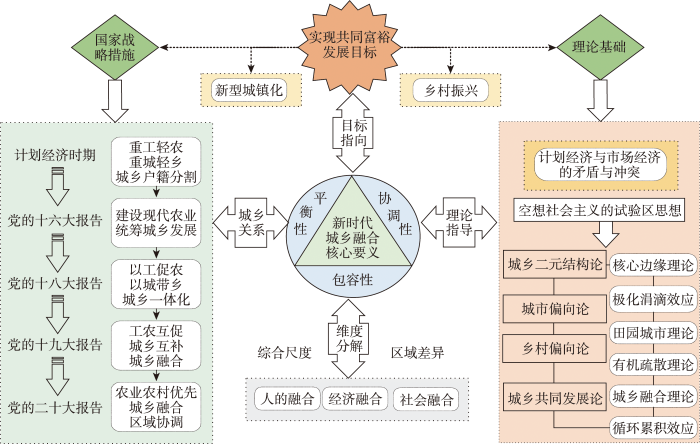
城乡融合的实质是将乡村和城市问题放在同一层面思考,通过畅通城乡要素双向流动通道,加速实现城乡等值化、市场一体化和公共服务均等化[23-24]。早在19世纪初,以圣西门、傅里叶和欧文为代表的空想社会主义者在批判和揭露资本主义的基础上,构想未来理想社会框架,为城乡融合发展奠定理论基础[25⇓-27]。19世纪中期,马克思等[28]提出了马克思主义城乡关系理论,强调城乡关系最终会实现融合发展。刘易斯[29]提出了著名的“二元经济结构理论”,认为发展中国家的农业部门剩余劳动力向现代工业部门持续转移过程能够消除二元经济结构。Ranis等[30]从动态平衡视角指出,只有同时发展农业和工业,才能有效解决农业部门因劳动力流失产生的系列问题。西方学者对城乡关系的理论研究进行了多方面探讨,在城乡二元结构论的基础上,形成了“城市偏向论”“乡村偏向论”和“城乡共同发展论”等理论学说。中国城乡关系经历了由城乡分割、城乡统筹、城乡一体化再到城乡融合的演变过程[1],产业发展方向由“重工轻农”“以工促农”到“工农互促”,城镇和乡村之间的作用关系不断发生变化。实现农村经济产业化、规模化和现代化发展是落实新型城镇化和乡村振兴两大国家战略的重要举措,当前亟需推动欠发达地区进入实现共同富裕的快速转型阶段,促进城乡融合发展[31]。国家发展和改革委员会颁布的《2022年新型城镇化和城乡融合发展重点任务》中,明确提出要推进城镇基础设施向乡村延伸、公共服务和社会事业向乡村覆盖。新型城镇化强调以人为本,是以城乡统筹、城乡一体和产城互动为基本特征的城镇化,旨在持续优化城镇空间布局。乡村振兴是解决“三农”问题的重要路径,也是实现区域协调发展的重要战略指向。新型城镇化与乡村振兴两大战略的有机结合所产生的共生效应是实现城乡融合的关键。
本文基于人的融合、经济融合、社会融合等[32⇓-34],提出共同富裕目标下城乡融合的内涵构成(图1),旨在构建城乡互补、协调发展、共同繁荣的城乡新格局:① 城乡融合的平衡性表现为统筹兼顾区域经济发展需求,坚持缩小城乡收入和消费差距。城乡居民收入和消费水平反映了人民物质富裕程度,是共同富裕的重要呈现内容[35]。强调城乡融合的平衡性,必须要充分满足城乡居民生活需求,避免城乡发展两极分化。② 包容性的核心在于人人享有公平、均衡的发展机会。迈向共同富裕的城乡融合动态特征区别于建设小康社会时期,需要畅通向上流动通道,为更多人创造致富机会。统筹城乡融合发展,建立健全的教育和医疗社会保障体系,完善城乡快速通道,把增进民生福祉作为城乡融合包容性的重要表征。③ 城乡融合的协调性针对于城镇和农村2个系统内部互动情况,立足于系统各要素的完善和调整,确保城乡融合系统能够合理运行。提高城乡融合发展的协调性,需要更加关注产业发展、劳动力转移、资本配置、建设用地等要素在城乡协调互动方面的资源流动[36]。实现农村产业化、现代化是城乡互动发展的动力机制,为缩小城乡差距提供坚实基础[37]。
图1
1.2 旅游发展与城乡融合协同关系
湘西地区此类欠发达地区旅游发展与城乡融合关系较为复杂,主要源于经济资源禀赋和地理区位条件,城乡空间经济发展不均衡影响城乡融合进程。长期以来,中西部欠发达地区是推进全体人民共同富裕最大的障碍,虽然中国已经历史性地解决了绝对贫困问题,但中西部地区仍然存在返贫风险。旅游业作为劳动密集型产业,其基本特点是产业联动能力和就业吸纳能力较强。旅游产业链的纵向延伸和横向关联为城乡融合注入了新活力[41],不仅从经济层面让旅游业发展成果惠及人民,更多的是为城乡居民带来除经济方面以外的福祉。一方面,由于旅游就业弹性较强,涉及食住行游购娱等方面,创造大量就业岗位,极大地解决了农业劳动力剩余问题[42];另一方面,发展旅游业提高了外出劳动力回流意愿[41],减小对乡村经济的负面影响,纠正城乡之间就业不平等问题。在旅游资源开发过程中,盘活城乡自然和人文资源,满足居民休闲生活需要,改善城乡人居环境,在物质和精神层面双轮驱动城乡融合。尤其是当乡村旅游微度假成为热潮,发展乡村旅游业实现了乡村文化景观资源的价值转换,依托农业优势实现“农旅”结合,是解决“三农”问题的重要突破口[11]。
城乡融合是保证旅游高质量发展的前期基础。首先,城乡融合强调统筹城乡基础设施建设,引导城镇更多要素资源流向乡村,完善乡村旅游服务功能。其次,城乡融合过程以农产品为基础延伸产业链,实现了三次产业融合发展,催生旅游新业态,引导外来资本流向农村[43]。最后,城乡融合为旅游发展营造了良好的社会生态环境,提高了区域旅游吸引力。总体来看,城乡融合过程通过实现产业兴旺、生活宜居、乡风文明、治理有效、生活富裕,为旅游业提供前提保障和发展契机。
2 研究区域与方法
2.1 研究区概况
湘西地区包括湘西土家族苗族自治州(简称湘西州)、张家界市和怀化市,辖区内共24个区县[44]。湘西地区民族文化特色浓厚,自然景观保存较为完好,截至2020年,共拥有3A级及以上景区60处,非物质文化遗产54个。自2000年西部大开发战略实施以来,政府部门加大对湘西地区民俗旅游资源和生态资源的开发,旅游业发展迅猛,城乡居民生活水平稳步提升。2021年中共湖南省委和湖南省人民政府联合发布的《关于新时代推进湘西地区开发形成新格局的意见》,明确指出要将湘西地区打造成脱贫地区高质量发展先行区、特色优势产业发展集聚区和国际知名生态文化旅游目的地。发展旅游业是湘西地区实现脱贫致富的重要路径,为推动城乡融合和实现共同富裕提供有力支撑。2012—2019年,湘西地区城镇化率由38%上升至47%,城乡年人均收入由21066元提升至27560元,旅游收入占GDP比重由23.2%上升至68.95%。2020年受新冠疫情的影响,旅游业遭受重创,旅游收入下降至1500亿元,相较上一年下降了24%。同时,乡村旅游市场迎来热潮,充分展示了乡村资源优势与价值。因此,当前需要更加关注湘西地区旅游资源的保护与利用情况,建立健全的城乡融合发展体制机制,打造城乡发展共同体。
2.2 指标体系构建
表1 旅游发展水平指标体系
Tab.1
| 准则层 | 评价指标 | 属性 | 单位 | 计算方法与指标来源 | 权重 |
|---|---|---|---|---|---|
| 发展性 | 休闲农业与乡村旅游星级企业与示范点 | 正向 | 个 | 反映乡村旅游建设情况,通过湖南省农业农村厅官网( | 0.040 |
| 景区资源禀赋 | 正向 | 采用等级赋权法对A级景区进行赋值,反映旅游吸引程度,数据源自湖南省文化和旅游厅( | 0.001 | ||
| 旅游人次增长率 | 正向 | % | (当年旅游人次-去年旅游人次)/去年旅游人次×100%,反映旅游经济发展情况,数据来自年度区县统计年鉴 | 0.023 | |
| 旅游空间密度 | 正向 | 人/hm2 | 旅游人次/国土空间面积,反映区域旅游接待能力,数据来自年度区县统计年鉴 | 0.040 | |
| 旅游收入增长率 | 正向 | % | (当年旅游收入-去年旅游收入)/去年旅游收入×100%,反映旅游经济发展水平,数据来自年度区县统计年鉴 | 0.011 | |
| 旅游收入占GDP比值 | 正向 | % | 反映旅游业对经济发展的重要程度,数据来自年度区县统计年鉴 | 0.094 | |
| 住宿餐饮年零售总额 | 正向 | 万元 | 体现旅游消费者购买能力,数据来自年度区县统计年鉴 | 0.181 | |
| 旅游企业法人单位数 | 正向 | 个 | 反映旅游业发展规模,数据由湖南省工商行政管理部门提供 | 0.071 | |
| 共享性 | 人均公共图书馆、文化馆、博物馆数量 | 正向 | 个 | 反映社会文化资本的共享程度,数据来自年度区县统计年鉴 | 0.101 |
| 文体与娱乐行业从业者 | 正向 | 人 | 反映居民旅游参与程度,数据来自年度区县统计年鉴 | 0.063 | |
| 人均旅游收入 | 正向 | 万元/人 | 旅游收入/总人口,反映旅游发展成果共享程度,数据来自年度区县统计年鉴 | 0.078 | |
| 互联网入户率 | 正向 | % | 反映旅游业发展新模式的开放程度,数据来自年度区县统计年鉴 | 0.043 | |
| 可持续性 | 森林覆盖率 | 正向 | % | 反映生态平衡状况,数据来自年度区县统计年鉴 | 0.001 |
| 城镇污水处理率 | 正向 | % | 反映城镇生活环境状况,数据来自年度区县统计年鉴 | 0.042 | |
| 非物质文化遗产数量 | 正向 | 个 | 反映民族文化深厚程度,数据源自国家级非物质文化遗产名录、人类口头与非物质遗产代表作名录 | 0.045 | |
| 物质文化遗产数量 | 正向 | 个 | 反映民族文化深厚程度,数据源自全国重点文物保护单位名录和世界遗产名录 | 0.089 | |
| 中国传统村落数量 | 正向 | 个 | 反映古村落遗产保护情况,数据来自传统村落官网( | 0.077 |
表2 城乡融合发展指标体系
Tab.2
| 目标层 | 评价指标 | 属性 | 计算方法与指标来源 | 权重 |
|---|---|---|---|---|
| 平衡性 | 城乡居民人均收入比 | 负向 | 城镇居民人均收入/农村居民人均收入,体现城乡经济发展的平衡性,数据来自年度市(州)统计年鉴和《湖南调查年鉴》 | 0.072 |
| 城乡居民人均收支结构差异 | 负向 | (城镇居民人均收入-农村居民人均收入)/(城镇居民人均消费支出-农村居民人均消费支出),体现城乡经济利益的平等性,数据来自年度区县国民经济和社会发展公报与《湖南调查年鉴》 | 0.095 | |
| 城乡居民恩格尔系数比 | 负向 | 城镇居民恩格尔系数/农村居民恩格尔系数,体现城乡居民生活质量差距,数据来自年度区县国民经济和社会发展公报与《湖南省调查年鉴》 | 0.056 | |
| 城镇化率 | 正向 | 城镇人口/常住总人口,用以估计农村人口转移为城镇人口的便捷程度,数据来自年度区县国民经济和社会发展公报 | 0.120 | |
| 城乡居民人均消费支出比 | 负向 | 城镇居民人均消费支出/农村居民人均消费支出,反映城乡居民生活水平差异,数据来自年度区县国民经济和社会发展公报与《湖南调查年鉴》 | 0.132 | |
| 包容性 | 每百名中小学生专任教师数量 | 正向 | 反映社会教育保障情况,数据来自年度区县国民经济和社会发展公报 | 0.023 |
| 每千人拥有医院、卫生院床位数量 | 正向 | 反映社会医疗保障水平,数据来自年度区县国民经济和社会发展公报 | 0.089 | |
| 公路密度 | 正向 | 公路通车里程/国土空间面积,反映城乡交通建设情况,数据来自年度市(州)统计年鉴 | 0.067 | |
| 城乡社区事务支出 | 正向 | 反映政府财政对城乡融合发展的支持力度,数据来自年度市(州)统计年鉴 | 0.043 | |
| 协调性 | 劳动力转移自由度 | 正向 | 乡村转移到城镇就业的劳动力数量/城镇新增劳动力,反映城乡融合过程中的制度创新和劳动力的融合便捷度,数据来自年度市(州)统计年鉴 | 0.066 |
| 产业协调互动能力 | 正向 | (第一产业产值/第一产业从业人员)/(第二、三产业产值/第二、三产业从业人员),数据来自年度区县统计年鉴 | 0.162 | |
| 农业现代化 | 正向 | 农业机械动力/常用耕地面积,反映农业生产效率,数据来自年度区县统计年鉴 | 0.075 | |
| 城乡土地互动情况 | 正向 | 乡镇建设用地/总土地面积,数据来自年度区县统计年鉴 | 0.076 |
2.2.1 旅游发展指标体系构建
实现共同富裕要求发展性、共享性和可持续性的统一,让全体人民享受同等发展机会,共享经济社会发展成果[45]。目前,关于旅游发展的指标体系构建主要基于经济、社会、文化和生态等维度[5,46-47]。本文结合共同富裕的时代内涵和经济高质量发展要求,从发展性、共享性和可持续性3个方面建立目标层,构建与经济、社会、文化和生态相关的指标体系,与共同富裕总目标存在对应关系。具体来看,旅游发展性要求旅游经济总量增强和旅游从业人员数量增加[48],选取休闲农业与乡村旅游星级企业与示范点数量、景区资源禀赋、旅游人次增长率、旅游空间密度、旅游收入增长率、旅游收入占GDP比值、住宿餐饮年零售总额和旅游企业法人单位数来衡量。
旅游发展起源于人们对美好生活的需要,始终坚持以人为核心[49]。旅游共享性必须要体现“公平”和“平等”等要素,使旅游发展成果能够惠及广大人民群众,这也是实现旅游业社会效益最大化的必然要求,选取公共图书馆、文化馆和博物馆数量、文体与娱乐行业从业者、人均旅游收入和互联网入户率来表征。
旅游可持续性的本质是保护生态环境和文化完整性。一方面,实现文化资源的旅游价值转换,发挥文化资源对提高国民素质和社会文明程度的作用[50];另一方面,发展旅游业充分贯彻了“绿水青山就是金山银山”的理念,在适度开发利用生态旅游资源的同时保护生态人居环境,使得生态资源价值可以更加广泛地转化为人民的共同财富。因此,选取森林覆盖率、非物质文化遗产数量、物质文化遗产数量、中国传统村落数量和城镇污水处理率加以衡量。
2.2.2 城乡融合指标体系构建
2.3 研究方法
2.3.1 熵权TOPSIS
2.3.2 哈肯模型
哈肯模型主要用于识别系统要素之间的序参量,并确定系统主要作用参量,构建参量之间的运动方程,从而判断系统发展的稳定点。根据哈肯协同理论,将旅游产业和城乡融合看作一个开放共生的系统,旅游发展—城乡融合系统较为复杂,内含多个子系统交互作用。由于一般均衡理论是建立在理想化假设的基础上,但现实中旅游发展和城乡融合的均衡状态较难实现,故假设复杂系统内部存在2个子系统,即序参量
式中:
构建系统演化方程,如式(4)所示。对式(4)进行相反数积分可得演化趋势函数,判断系统是否存在相对稳定的发展状态,如式(5)所示。
然而,由于各地区旅游发展与城乡融合虽然可能存在协同效应,但不一定满足“绝热近似假设”。本文参考已有研究[53]对模型做了如下改进:如果存在
由于式(1)、(2)是针对连续性变量设定的,运用协同模型探讨旅游发展与城乡融合协同关系时,需要对式(1)、(2)进行离散化处理,得到旅游发展(TD)与城乡融合(URI)协同演化方程,其中t为时间变量:
根据哈肯模型基本原理,以TD和URI为变量,构建协同模型,判断模型假设是否成立,并识别系统序参量,对参数求解。从表3可知,TD在旅游发展与城乡融合的协同演化过程起主导作用,参数计算结果为:
表3 2012—2020年变量分析结果
Tab.3
| 模型假设 | 协同演化方程 | 参数信息 | 模型结论 |
|---|---|---|---|
| 运动方程成立;满足模型假设; | |||
系统演化方程为:
令
2.3.3 泰尔指数
泰尔指数将区域总体差异划分为地区间差异和地区内差异,其取值范围为0~1,数值越小代表差异越小。本文利用泰尔指数将湘西地区旅游发展与城乡融合协同值空间差异分解为张家界市内部差异、怀化市内部差异、湘西州内部差异以及三者之间的差异,并计算对区域总体差异的贡献率[56]。
式中:
2.3.4 面板灰色关联模型
面板灰色关联模型是在指数函数的基础上扩展而成的灰色关联度模型,针对面板数据在时间和空间上的发展程度和方向,将指标之间的“增量差”和“离差的差”的绝对值转化为度量曲线的相似程度,根据方向差异判断影响程度的正负。本文采用面板灰色关联模型分析影响旅游发展与城乡融合协同关系的关键因素,具体公式见参考文献[57]。
3 实证分析
3.1 湘西地区旅游发展与城乡融合水平测度
3.1.1 旅游发展水平测度
根据上述评价理念及计算方法,分别计算2012—2020年湘西地区旅游发展水平,结果如图2所示。由图2可知,2012、2016、2019、2020年湘西地区旅游发展水平的均值分别为0.268、0.227、0.279和0.250,呈现“下降—上升—下降”的演化趋势,在2016年下降至最低水平,2019年大幅度回升以后又转为下降态势。根据2012—2020年旅游发展各子维度的均值判断,湘西地区整体表现为旅游可持续性>旅游发展性>旅游共享性,由于地区旅游资源禀赋较高,加之近几年政府对生态环境存在的问题进行了整改,极大推动了区域可持续发展。同时,旅游共享经济是新型消费的重要形态,湘西地区旅游发展的共享性亟待提升,以确保能更好地调配区域旅游发展各项生产、生活和生态资源。从各子维度下不同区县的对应值来看,永定的旅游发展性、武陵源的旅游共享性和永顺的旅游可持续性相对高于其他区县。因此,应当积极发挥以上地区的示范带动作用,不断推动区域旅游高质量发展。
图2
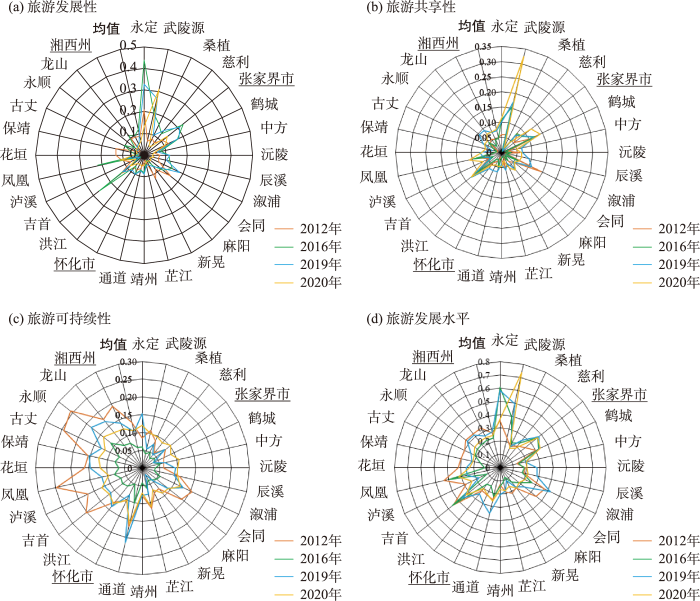
图2
湘西地区旅游发展水平测度
Fig.2
Analysis of tourism development in the Western Hunan region
3.1.2 城乡融合水平测度
由图3可知,2012—2020年湘西地区城乡融合发展水平总体偏低,经历小幅度波动。2012、2016、2019和2020年的城乡融合发展水平均值分别为0.431、0.291、0.355和0.423。具体来看,2016年湘西地区城乡融合发展水平比2012年下降了32.48%,这可能是因为湘西地区在此期间过于注重城镇化建设,对乡村发展的关注度不够高,导致城乡差距逐渐扩大;与2016年相比,2019年城乡融合发展水平的增长率为22.09%,在国家相关战略政策的调控下,城乡经济发展逐渐步入正轨,区域协调发展态势愈加明显;相较2019年,2020年城乡融合发展水平上升了19.20%,这也体现了湘西地区城乡融合进程已经进入了相对稳定的阶段。从城乡融合系统子维度来看,2012、2016、2019、2020年平衡性均值分别为0.208、0.120、0.163、0.174;包容性均值分别为0.116、0.071、0.060和0.067;协调性均值分别为0.106、0.099、0.130、0.182。可以看出,2012—2020年湘西地区城乡融合发展水平各子维度的均值大小表现为:平衡性>协调性>包容性。因此,应当提高城乡包容性,把城乡融合过程变成缩小城乡之间差距的过程,推进城乡双向开放。
图3
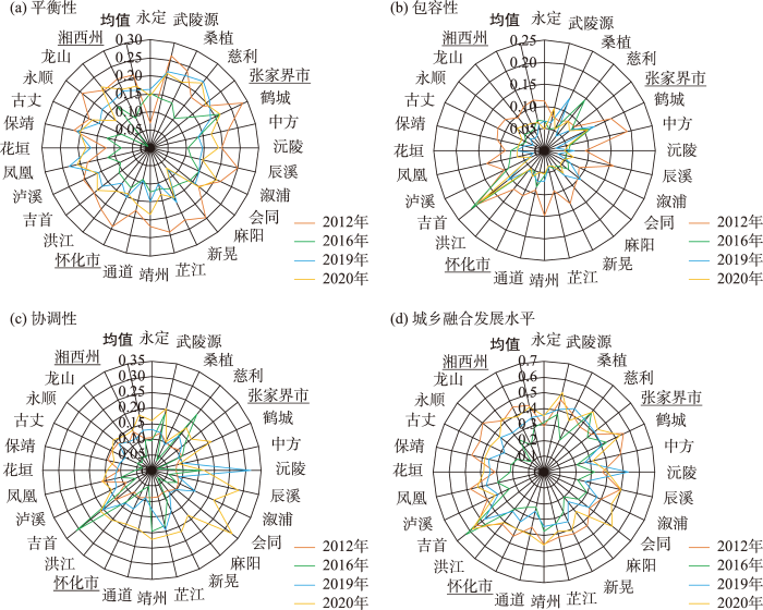
图3
湘西地区城乡融合发展水平测度
Fig.3
Analysis of urban-rural integration in the Western Hunan region
3.2 旅游发展与城乡融合协同度的时序特征
从图4可以看出,2012—2013年湘西地区旅游发展与城乡融合的协同作用有所增强。究其原因,2013年《中华人民共和国旅游法》的颁布为规范旅游市场秩序提供了有力保障,旅游发展促进了城乡融合;同时,城乡融合为旅游业发展奠定了良好的物质基础。而在2013—2015年协同值下降,部分原因是政府和企业过于重视旅游经济效益最大化,忽视了城乡基础要素的合理配置。由于旅游利益分配不均,造成旅游发展与城乡融合的协同关系受损。2015—2017年湘西地区旅游发展和城乡融合的协同值变化幅度不大,保持较为稳定的发展态势。但在2017—2020年旅游发展与城乡融合的协同值由0.389波动上升至0.474。总体来看,2012—2020年期间湘西地区旅游发展与城乡融合的协同关系未能够跃迁至高级协同阶段。可见,湘西地区应当主动把握新发展阶段契机和掌握资源禀赋优势,以共同富裕理念指导旅游高质量发展和城乡有效融合。
图4
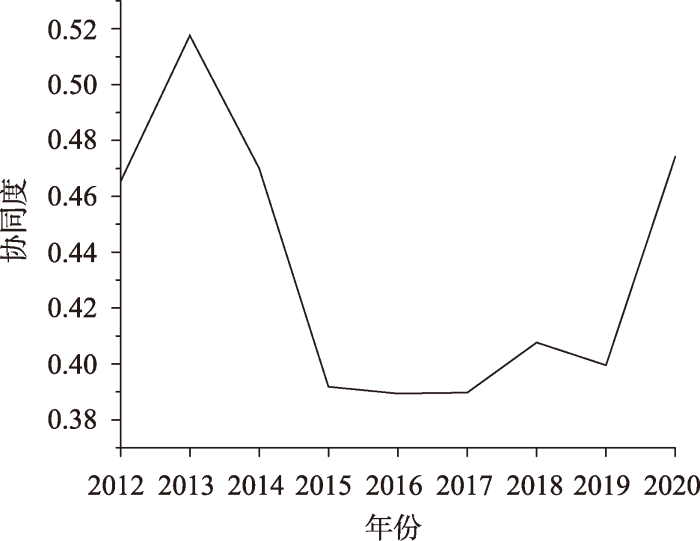
图4
湘西地区旅游发展与城乡融合协同度
Fig.4
Degree of synergy of tourism development and urban-rural integration in the Western Hunan region
3.3 旅游发展与城乡融合协同度的空间差异特征
3.3.1 区域空间分布差异
为进一步反映湘西地区24个区县旅游发展与城乡融合协同类型,将协同值进行可视化分析(图5)。从图5可以发现,2012—2020年湘西地区24个区县旅游发展与城乡融合协同值呈现波动起伏特征。2012—2020年,张家界市的永定一直是高级协同地区,湘西州的吉首恒为初级协同地区,而怀化的沅陵、泸溪、芷江和新晃始终处于中级协同阶段,以上地区协同发展水平较为稳定,路径依赖特征较强,未发生等级跃迁。究其原因,可能是因为永定作为张家界市府所在地,是张家界实施乡村振兴战略的主战场;同时,作为张家界旅游核心服务区和核心景区所在地,永定已初步实现“农业+旅游”的经营发展模式。其次,吉首作为中国中西部地区交接节点,城镇化进程相对其他地区较高,但由于在快速城镇化进程中公共服务基础设施、建设用地和要素配置尚未形成良性发展态势,城乡差距较为显著。最后,沅陵、泸溪、芷江和新晃结合产业发展特色,借助区域增长极的辐射传导效应,助力城乡融合趋于稳步发展态势。具体来看,2012年湘西地区协同值总体呈现“中间大、两头小”的橄榄形态,高级协同地区数量偏少,区域协同差异较大;2016年,高级协同地区数量增加,初级协同地区数量减少,表明随着旅游产业多样化发展、产业结构转型升级以及公共服务设施的不断完善,部分地区旅游发展和城乡融合的协同关系逐渐由初级协同和中级协同跃迁至高级协同阶段,旅游发展与城乡融合相互作用程度相对增强;2020年,由于旅游业受新冠疫情影响冲击较大,给区域经济发展带来较大的不稳定性,大部分地区协同类型下降为中级协同,初级协同地区数量增多,形成了以永定为增长极的空间格局。这说明旅游发展与城乡融合协同空间结构的稳定性较差,旅游流及城乡要素流在不同地区之间的渗透强度不高。
图5
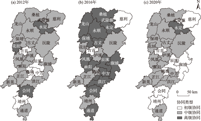
图5
湘西地区各区县旅游发展与城乡融合协同空间差异
Fig.5
Spatial differences in the degree of synergy of tourism development and urban-rural integration among districts and counties in the Western Hunan region
3.3.2 市州与区县差异分析
运用泰尔指数进一步对湘西地区旅游发展与城乡融合协同值的区域差异进行分析,得到结果如表4所示。从表4可知,2012—2017年湘西地区旅游发展与城乡融合的协同值差距呈现“下降—上升”的周期性循环波动趋势。具体来看,总体差异主要来自地区内的差异,地区内差异对于总体差异的贡献度均大于87%,由2012年的90.229%上升至2020年的94.226%,期间经历了较小起伏,这说明湘西地区3个市州管辖下的区县协同差距在不断扩大。地区间差异对总体差异的贡献度由2012年的9.771%下降至2020年的5.774%,表明湘西地区3个市(州)的差异在逐渐减小。从组间差异来看,怀化市的协同值空间差异在缩小,湘西州和张家界市的协同空间差异在扩大。这与各市(州)在资源禀赋、经济发展基础以及产业结构等方面的差异息息相关。
表4 2012—2020年湘西地区旅游发展与城乡融合协同值泰尔指数分解及贡献率
Tab.4
| 年份 | 泰尔指数 | 贡献率/% | ||||||||||
|---|---|---|---|---|---|---|---|---|---|---|---|---|
| 总指数 | 张家界 | 怀化 | 湘西州 | 地区内 | 地区间 | 张家界 | 怀化 | 湘西州 | 地区内 | 地区间 | ||
| 2012 | 0.084 | 0.075 | 0.100 | 0.046 | 0.076 | 0.008 | 18.008 | 52.324 | 19.498 | 90.229 | 9.771 | |
| 2013 | 0.078 | 0.047 | 0.100 | 0.041 | 0.068 | 0.010 | 9.031 | 57.422 | 20.937 | 87.391 | 12.609 | |
| 2014 | 0.081 | 0.053 | 0.111 | 0.049 | 0.079 | 0.002 | 12.151 | 64.846 | 20.878 | 97.878 | 2.122 | |
| 2015 | 0.031 | 0.030 | 0.030 | 0.028 | 0.029 | 0.002 | 14.898 | 45.307 | 32.803 | 93.017 | 6.983 | |
| 2016 | 0.062 | 0.054 | 0.025 | 0.114 | 0.061 | 0.001 | 14.889 | 19.435 | 64.361 | 98.693 | 1.307 | |
| 2017 | 0.044 | 0.015 | 0.028 | 0.061 | 0.038 | 0.006 | 4.524 | 32.869 | 49.726 | 87.111 | 12.889 | |
| 2018 | 0.074 | 0.073 | 0.065 | 0.063 | 0.065 | 0.009 | 16.613 | 38.434 | 33.156 | 88.204 | 11.796 | |
| 2019 | 0.038 | 0.040 | 0.048 | 0.017 | 0.036 | 0.002 | 15.273 | 64.419 | 15.416 | 95.121 | 4.879 | |
| 2020 | 0.090 | 0.158 | 0.086 | 0.052 | 0.085 | 0.005 | 27.815 | 44.176 | 22.235 | 94.226 | 5.774 | |
3.4 旅游发展与城乡融合协同发展的影响因素
3.4.1 影响因素的选择
为了探寻影响旅游发展与城乡融合协同关系的关键因素,参考相关文献[5,9,44],结合湘西地区作为脱贫地区的发展实际,选取以下影响因素进行测量:① 经济发展水平(ECO)。经济发展水平较高的地区公共服务基础设施建设相对完善,更加能够吸引外商入驻,为区域发展提供物质支撑[55]。旅游发展与城乡融合的协同演化需要依托物质基础条件,故以人均GDP的对数表示。② 技术创新水平(TNI)的提高有助于实现城乡产业协同发展和区域经济高质量发展,故使用农业机械化程度表征。③ 市场化水平(MAR)。市场交换是实现旅游资源价值转换最有效的方式,通过降低旅游市场交易成本,提高城乡资源配置效率。已有研究证明,市场化水平越高的地区,旅游经济越发达[58],故采用民营经济增加值占GDP比重表征[59]。④ 产业结构高级化程度(IND)。根据动态比较费用论,重点发展传统技术层次较低的产业的同时,必须扶持具有发展前景的新兴产业,实现产业比较成本转换。随着以第三产业为主的配套服务业发展水平的不断提升,为旅游发展提供有力支撑,促进城乡融合发展,故采用第三产业增加值与第二产业增加值之比来衡量。⑤ 政策帮扶力度(GTH)。湘西地区作为曾经的贫困地区,政府投入能力对贫困地区实现脱贫致富至关重要。财政扶贫专项资金投入可以反映政府对贫困地区的帮扶力度[7],其使用情况主要用来改善交通条件设施、公共服务设施、开发旅游景区等方面,实现政策向贫困地区倾斜,促使城乡居民共享旅游发展红利。
3.4.2 影响因素的时间差异分析
表5 旅游发展与城乡融合协同值的影响因素灰色关联度
Tab.5
| 年份 | TNI | IND | ECO | MAR | GTH |
|---|---|---|---|---|---|
| 2012 | 0.760* | 0.704 | 0.850*** | 0.881*** | 0.773* |
| 2013 | 0.785* | 0.840** | 0.878*** | 0.897*** | 0.774* |
| 2014 | 0.739 | 0.783* | 0.831** | 0.873*** | 0.755* |
| 2015 | 0.749 | 0.859*** | 0.878*** | 0.891*** | 0.760* |
| 2016 | 0.637 | 0.814** | 0.858*** | 0.862*** | 0.673 |
| 2017 | 0.643 | 0.843** | 0.779* | 0.868*** | 0.688 |
| 2018 | 0.734 | 0.778* | 0.818** | 0.827** | 0.768* |
| 2019 | 0.707 | 0.746 | 0.825** | 0.740 | 0.699 |
| 2020 | 0.695 | 0.805** | 0.814** | 0.628 | 0.704 |
| 均值 | 0.717 | 0.797 * | 0.837** | 0.830** | 0.733 |
注:*、**、***分别表示灰色相对关联度值为[0.75,0.80]、(0.80, 0.85]和(0.85, 0.90]。
从表5可知,经济发展水平对旅游发展与城乡融合协同关系的影响最大,指标灰色关联度均值为0.837。具体来看,2012—2020年,经济发展水平的灰色关联度呈现“上升—下降—上升”的变化特征,总体上对协同度的影响逐渐减弱,但相比其他因素,影响程度仍然较大。这说明良好的经济环境对旅游发展与城乡融合的协同关系具有重要影响。2012—2020年,湘西地区人均GDP值由20326.67元上升至34387.67元,经济发展成效显著,为湘西地区加快形成新发展格局奠定了良好的基础。
市场化程度的提升有助于吸引外来资金投入、企业进驻,为区域发展营造更加宽容的制度环境。由于旅游产业链延伸广、进入门槛低,有助于吸纳剩余劳动力和提升劳动力就业转移自由度,逐步向市场化发展。根据测算结果,市场化指标的灰色关联度均值为0.830。湘西地区毗邻重庆、贵州、广西等西部省份,早期受困于山区地理环境的复杂性,缺少资金技术支持,市场相对狭小。自2000年西部大开发战略实施以来,政府制定了一系列优惠政策,使得东部地区的人流、物流、资金流和信息流大量涌入西部地区,东西部地区交流合作机会增加,推动了区域市场化进程。
产业结构高级化作为衡量产业结构的核心指标,在产业之间相互促进、相互调节的过程中,其资源配置对旅游发展与城乡融合协同演化具有较大影响。但相对来看,产业结构高级化对旅游发展与城乡融合协同值的影响最低,其灰色关联度均值为0.797。湘西地区早期主要以农业经济为主,第一产业较为发达。随着政府对区域发展特色的清晰定位,为践行“绿水青山就是金山银山”的发展理念,依托少数民族文化特色和独特自然景观,通过旅游业的强示范作用带动相关产业链发展,使得三次产业结构呈三、二、一格局。其中,第三产业增加值占GDP比重逐年攀升,从2012年的50.1%升至2019年的58.1%。尽管2020年受疫情影响,但湘西地区牢牢把握旅游业发展的“逆周期”特征,采取系列措施使得以旅游业为主的第三产业发展稳步回升,第三产业增加值占GDP比重下降幅度较小,相较于2012年,年均增长率达到1.6%。由此可见,第三产业增长立足于资源禀赋,通过实现产业结构转型升级,在实现全面脱贫和乡村振兴实践中发挥着关键作用。
3.4.3 影响因素的区域差异分析
根据湘西地区各区县的灰色关联度结果可以看出(表6),对于产业结构高级化因子而言,桑植、慈利、鹤城的灰色关联度相对较高,对应值均在0.77以上。此类地区产业结构系统逐渐由第一产业向第三产业转移,通过增生新兴业态和产业规范化,促进服务业现代化发展,为稳就业、保民生、促发展提供契机。武陵源(0.616)是所有区县中唯一关联度低于0.7的地区。具体来看,武陵源产业高级化程度从2012年的45.238%下降至2020年的29.374%,产业结构总体稳定性较差,相对其他地区,产业结构高级化对旅游发展与城乡融合协同演化影响较小。
表6 湘西地区各县(市、区)影响因素与协同值的灰色关联度
Tab.6
| 区县名称 | IND | ECO | MAR | 区县名称 | IND | ECO | MAR |
|---|---|---|---|---|---|---|---|
| 永定 | 0.714 | 0.683 | 0.575 | 芷江 | 0.752 | 0.885 | 0.915 |
| 武陵源 | 0.616 | 0.653 | 0.569 | 靖州 | 0.754 | 0.895 | 0.923 |
| 桑植 | 0.784 | 0.829 | 0.851 | 通道 | 0.751 | 0.908 | 0.932 |
| 慈利 | 0.833 | 0.831 | 0.811 | 洪江 | 0.756 | 0.867 | 0.934 |
| 鹤城 | 0.774 | 0.783 | 0.847 | 吉首 | 0.757 | 0.754 | 0.799 |
| 中方 | 0.734 | 0.776 | 0.879 | 泸溪 | 0.763 | 0.856 | 0.940 |
| 沅陵 | 0.715 | 0.760 | 0.844 | 凤凰 | 0.826 | 0.829 | 0.823 |
| 辰溪 | 0.737 | 0.785 | 0.845 | 花垣 | 0.875 | 0.904 | 0.920 |
| 溆浦 | 0.746 | 0.695 | 0.869 | 保靖 | 0.860 | 0.898 | 0.938 |
| 会同 | 0.753 | 0.906 | 0.910 | 古丈 | 0.754 | 0.871 | 0.819 |
| 麻阳 | 0.759 | 0.916 | 0.910 | 永顺 | 0.738 | 0.833 | 0.899 |
| 新晃 | 0.752 | 0.911 | 0.951 | 龙山 | 0.747 | 0.876 | 0.946 |
对于经济发展水平因子而言,会同、麻阳、新晃、通道和花垣的灰色关联度均在0.9以上,而武陵源、永定和溆浦与协同值的灰色关联度在0.7以下。这反映了欠发达地区对经济发展的高度依赖,只有夯实物质基础,实现区域经济高质量发展,才能加快实现共同富裕发展目标。2012—2020年永定GDP一直位于区域前列,经济发展水平的提高为旅游业和城乡融合创造了良好的发展环境。同时,永定致力于促进“旅游+文化”深度融合,开发系列文旅项目,持续提升《天门狐仙》等旅游演艺业质量水平。溆浦是怀化市除市辖区鹤城区以外GDP最高的地区和革命老区,2014年溆浦高铁南站的开通,使得溆浦正式步入“高铁时代”,完全融入省会长沙2 h经济圈,极大加强了对外交流能力。
对于市场化程度因子而言,中国一直鼓励各类市场主体在有效保护旅游资源的前提下,通过分离旅游景区管理权和经营权,直接承包、租赁、投资和开发旅游资源。新晃、龙山和泸溪市场化水平与协同值的灰色关联度范围为[0.940,0.951],总体关联水平相对较高。龙山致力于“旅游+影视”融合发展,太平山景区的开发成功地为地方旅游景区发展引入了市场化运作机制;新晃积极推进市场流动领域“五化”政治新模式;泸溪不断强化“政银企”对接交流机制。总体来看,这3个地区一直致力于优化营商环境,依托旅游景区加速推进服务配套设施建设和市场化运营,不断推动土地、资金、劳动力要素转换融合,重塑新型城乡关系。
4 结论与启示
城乡融合已成为新时代实现社会高质量发展的现实命题,而发展旅游业是推进城乡融合的重要路径。探究旅游发展和城乡融合的协同效应,可为其他欠发达地区实现乡村振兴和新型城镇化协调发展,进而加快实现共同富裕目标提供科学的理论依据和实践指导。本文运用熵值TOPSIS模型、泰尔指数以及哈肯模型分别探讨欠发达地区湘西地区旅游发展水平、城乡融合发展水平以及二者之间的协同演化趋势,采用面板灰色关联模型探寻旅游发展与城乡融合协同值的影响因素。研究发现:
(1) 2012—2020年湘西地区旅游发展和城乡融合发展水平表现小幅度波动交替演化特征,总体呈现下降态势。其中,旅游可持续性>旅游发展性>旅游共享性,平衡性>协调性>包容性。当前,亟待提升旅游发展的共享性和城乡之间的包容性,推进城乡双向开放,确保旅游发展成果为本地居民所共享,更好地调配区域各项生产、生活和生态资源。
(2) 旅游发展水平是湘西地区旅游发展与城乡融合协同演化的序参量,推动区域实现无序到有序的高级演化。旅游业与城乡融合作为2个复杂巨系统,旅游创收能够缩小城乡收入差距、实现城乡资源共享和发展机会平等。同时,城乡融合发展水平的提高,能够夯实物质基础,为旅游发展营造良好的经济、文化、生态和社会环境,以加快实现旅游产业转型升级。湘西地区旅游发展与城乡融合之间的相互作用、相互反馈,产生了协同效应。但是,由于部分地区的发展滞后性,区域整体未能跃迁至高级协同阶段,更深层次空间结构尚未形成。
(3) 湘西地区旅游发展与城乡融合协同空间差异呈现波动起伏特征,总体差异源自于地区内各区县的差异。其中,怀化市的协同空间差异缩小,湘西州和张家界市的协同空间差异扩大。这进一步说明了湘西地区旅游发展与城乡融合协同演化的非均衡格局依然存在,协同发展空间结构的稳定性较差,旅游流及城乡要素流在不同地区之间的渗透强度不高。
(4) 湘西地区旅游发展与城乡融合的协同值与经济发展、市场化程度和产业结构高级化存在密切关联,其重要性表现为:经济发展>市场化程度>产业结构高级化程度。由于各因素在不同地区与协同值的关联度不同,形成了湘西地区旅游发展与城乡融合协同值的区域差异。
本文的研究结论可为相关部门制定合理的区域发展政策提供参考价值。第一,共享经济的快速发展将为消除欠发达地区在利用市场方面的劣势地位带来机遇。湘西地区旅游业发展已经进入了转型升级时期,需要加快提高旅游共享性和城乡包容性,建立旅游从业人员培训机制,让欠发达地区最大化实现旅游发展成果为人民共享。整合区域人文资源与自然资源,借助国家公园模式、管理委员会模式和公司管理模式,实现跨行政区域的旅游资源与品牌一体化共享。第二,充分挖掘欠发达地区生态资源禀赋以提高第三产业的产值比重,加快三次产业融合发展和产业结构高级化,通过收入再分配制度实现城乡居民收入分配的合理化。优化区域价格机制、供需机制和竞争机制,培育和完善区域市场化制度,引导旅游业的资金流和信息流的合理流动。同时,深化农村体制机制改革,实现城乡资本配置带动经济增长目的,推动湘西地区加快进入旅游发展与城乡融合高级协同阶段。第三,努力实现旅游发展与城乡融合协同发展。旅游发展与城乡融合具有协同促进效应已经得到了证实,关键是如何进一步提升二者间的协同效应,创新旅游发展与城乡融合的体制机制。由于湘西地区此类欠发达地区尚处于旅游产业集聚的发展状态,对比发达地区,资源配置容易边缘化,对空间分配正义的诉求更高。因此,需要科学把握不同协同类型地区的功能定位,保证城乡要素流动的自由性,形成城乡融合互动发展的新格局。
参考文献
乡村振兴战略实施背景下的新型城乡关系构建: 意义、困境及纾解
[J].
The construction of new urban-rural relations in the context of rural revitalization strategy: Meaning, difficulties and relief
中华人民共和国国民经济和社会发展第十四个五年规划和 2035 年远景目标纲要
[R/OL].
Outline of the fourteenth five-year plan for national economic and social development of the People's Republic of China and the longterm goals for 2035
中共中央国务院关于建立健全城乡融合发展体制机制和政策体系的意见
[R/OL].
Opinions of the CPC Central Committee and the State Council on establishing and perfecting the institutional mechanism and policy system of urban-rural integration development
中国旅游发展与城乡收入差距关系的空间计量分析
[J].
Spatial econometric research on the relationship between tourism development and urban-rural income gap in China
旅游发展能否减小城乡收入差距? 来自中国的经验证据
[J].
Can tourism development reduce the urban-rural income gap? An empirical evidence from China
乡村旅游引导乡村振兴的研究框架与展望
[J].
DOI:10.11821/dlyj020180454
[本文引用: 2]

中国特色社会主义进入新时代,城乡发展不平衡、乡村发展不充分等问题日益突出,实施乡村振兴战略是解决人民日益增长的美好生活需要和不平衡不充分的发展之间矛盾的必然要求。发展乡村旅游能够有力地契合和服务新时代国家发展战略,促进农业提质增效、农民增收致富、农村繁荣稳定,加快统筹城乡融合发展步伐,是实现乡村振兴的重要途径。系统梳理国内外乡村旅游引导乡村振兴的相关研究成果,针对内容深度相对薄弱、功能拓展比较泛化、时代特征不够显著等问题,把握新时代乡村旅游发展的新特点、新使命、新要求,充分考虑中国是一个发展中的经济大国、人口大国、农业大国的基本国情,构建了融合地理学、旅游学、经济学、社会学、管理学等相关学科理论的新时代中国乡村旅游引导乡村振兴的研究框架,归纳了乡村旅游引导乡村振兴的五个重点研究内容,即乡村旅游引导乡村振兴的学理和逻辑机理研究、乡村旅游引导乡村经济振兴的路径研究、乡村旅游引导乡村生态宜居的路径研究、乡村旅游引导乡村治理体系重构的路径研究、乡村旅游引导乡村振兴的政策体系研究。五个重点研究内容包括理论层面、实践层面和保障层面,在相互联系、相互影响、相互作用中共同促进城乡融合发展,实现乡村振兴的科学、持续、健康发展。掌握和运用科学的方法论,汲取科学方法论的智慧和营养,构建多方法综合集成的方法体系,确保数据采集的真实性和数据处理的科学性,是新时代乡村旅游引导乡村振兴研究的关键。
The research framework and prospect of rural revitalization led by rural tourism
DOI:10.11821/dlyj020180454
[本文引用: 2]
Socialism with Chinese characteristics has entered the new era. Problems such as unbalanced development between urban and rural and inadequate development in rural areas have become increasingly prominent. The implementation of the rural revitalization strategy is an inevitable requirement for resolving the contradictions between unbalanced and inadequate development and the people's ever-growing needs for a better life. With the rapid advancement of new industrialization and new urbanization, China's rural tourism has entered the era of big tourism instead of small and medium tourism. The development of rural tourism can effectively pursue the development strategy of the country in the new era, promote agricultural quality and efficiency, increase farmers' income, make the countryside prosperous and stable, and speed up the development of urban-rural integration. Therefore, it is an important way to realizing rural revitalization. This paper has reviewed the related research on rural revitalization led by rural tourism at home and abroad. In addition, it has grasped the new characteristics, new missions and new requirements of rural tourism development in the new era. Considering the basic situation of China as a developing economic power, and a large agricultural country with a large population, this paper has constructed a research framework of rural revitalization led by rural tourism in China in the new era, which integrates theories of geography, tourism, economics, sociology, management and other related disciplines. It has summarized the five key research contents of rural revitalization led by rural tourism, which contains study on theory and logic mechanism of rural revitalization led by rural tourism, study on the path of rural economy revitalization led by rural tourism, study on the path of rural ecological livability led by rural tourism, study on the path of reconstruction of rural governance system led by rural tourism and study on the policy system of rural revitalization led by rural tourism. The five key research contents cover the theoretical, practical and safeguard aspects, promote the development of urban-rural integration through interconnection, mutual influence and interaction, and ultimately realize the scientific, sustained, and healthy development of the rural revitalization strategy. In the new era, the key of rural revitalization led by rural tourism is to master and apply scientific methodology, to learn the wisdom and nutrition of scientific methodology, to construct a method system for multi-method comprehensive integration, and to ensure the authenticity of data collection and the scientificalness of data processing.
民族地区旅游经济发展对城乡居民收入差距的影响: 基于面板门限模型的分析
[J].
The impact of tourism economic development in ethnic areas on the income gap between urban and rural residents: Analysis based on panel threshold model
旅游产业集聚、城镇化与城乡收入差距基于省级面板数据的实证研究
[J].
Tourism industrial agglomeration, urbanization and urban-rural income gap: An empirical study based on provincial panel data
旅游恩格尔系数对我国城乡居民生活质量和幸福度的跟踪试验
[J].
Tourism Engel coefficient on China's urban and rural residents: A follow-up experiment of quality of life and happiness
乡村旅游开发对促进城乡统筹发展的作用
[J].
The role of rural tourism development in promoting the integrated development of urban and rural areas
区域旅游开发与城乡协调发展的内在影响研究
[J].
Research on harmonizing development between city and countryside and regional tourism exploitation
DOI:10.2307/141986 URL [本文引用: 1]
长三角旅游吸引物城乡空间分异特征
[J].
DOI:10.13249/j.cnki.sgs.2022.08.013
[本文引用: 1]
基于长三角地区1663个3A级旅游景区数据,采用GIS空间分析技术与地理探测器方法,对长三角旅游吸引的城乡空间分异特征及影响因素进行了探究。结果表明:① 长三角旅游吸引物空间分布不均衡性显著,表现出“整体分散,核心集聚”的空间分布特征,“单核、多中心、层级化”的格局特征显著,集聚形态上呈现出明显的“核心-边缘”结构;② 城区吸引物集聚程度高于乡村地区,省域间城乡吸引物分布各有侧重,根据景区丰度指数可将长三角41市划分为“城乡双高型”“城区集聚型”“乡村集聚型”和“城乡双低型”4类旅游地;③ 长三角旅游吸引物城乡分异特征主要是由自然、经济、社会三大因素互相交织、共同作用的结果,但城乡吸引物的空间格局影响因素存在显著差异。
Spatial differentiation characteristics of urban and rural tourist attractions in the Yangtze River Delta
DOI:10.13249/j.cnki.sgs.2022.08.013
[本文引用: 1]
This article based on the data of 1663 3A tourist attractions in the Yangtze River Delta region, the spatial differentiation characteristics and influencing factors of tourism attraction between urban and rural areas in the Yangtze River Delta region were explored by using GIS spatial analysis technology and geographic detector method. The results show that: 1) The spatial distribution of tourism attractions in the Yangtze River Delta is significantly unbalanced, showing the spatial distribution characteristics of ‘overall dispersion, core agglomeration’, the pattern of ‘single-core, multi-center, hierarchical’ is significant, and the agglomeration form shows an obvious ‘core-edge’ structure. 2) The degree of urban attraction concentration is higher than that of rural areas, and the distribution of urban and rural attractions between provinces has different emphasis. According to the scenic abundance index, 41 cities in the Yangtze River Delta can be divided into four types: ‘Urban & rural double-high type’ ‘urban agglomeration type’ ‘rural agglomeration type’ and ‘urban & rural double-low type’. 3) The urban-rural differentiation of tourism attractions in the Yangtze River Delta is mainly the result of the interaction of natural, economic and social factors, but there are significant differences in the strength of the influencing factors of the spatial pattern of urban and rural attractions. The results will provide a scientific basis for optimizing the spatial structure of tourism attractions in the Yangtze River Delta, promoting the optimal allocation of regional urban and rural tourism elements, and promoting the balanced development of tourism integration.
The nonlinear effects of tourism on rural income inequality and urban-rural income inequality: Evidence from China
[J].
DOI:10.1177/13548166211041802
URL
[本文引用: 1]
Tourism’s relationship with income inequality is a hot spot in the academic community; however, few studies focus on how tourism shapes rural income inequality, despite its significant role in rural poverty alleviation. This article investigates the nonlinear effects of tourism on urban–rural income inequality and rural income inequality based on data from China’s provincial regions over the period 1995–2018, using the dynamic panel data approach. This study further examines the regional heterogeneity of such effects. The results demonstrate that for the national sample, there exists a significant cubic curve relationship between domestic tourism and rural income inequality. However, inbound tourism’s relationship with rural income inequality is not significant. Besides, there exists an N-shaped Kuznets curve between domestic or inbound tourism and urban–rural income inequality. The effects of tourism on rural income inequality and urban–rural income inequality vary significantly across the eastern, middle, and western regions. From east to middle to west, the significance of inbound tourism’s influence on income inequality decreases gradually. This study also highlights some critical theoretical and practical implications. Unlike prior studies, this article builds the first comprehensive research framework consisting of tourism, rural income inequality, and urban–rural income inequality.
World heritage tourism triggers urban-rural reverse migration and social change
[J].
DOI:10.1177/0047287519853048
URL
[本文引用: 1]
We show that tourism to a World Heritage Area generates economic opportunities in nearby rural communities, sufficient to reverse migration to the city. To carry out this test, we used an isolated region with a simple economic structure and a newly declared WHA, and analyzed economic constraints, opportunities, and decision processes at the micro scale of individual households, through qualitative analysis of interviews and on-site audits. Tourism triggered a switch from accelerating decline of rural villages, with closing schools and abandoned buildings and farmland, to accelerating recovery and reinvigoration, with new ecolodges and adventure tours employing household members and other local residents. The switch was assisted by low-interest ecotourism loans. It has also generated new economic opportunities for women specifically, and these have created much greater social freedom and self-determination, now also accepted by men.
Out of the city-but how and where? A mode-destination choice model for urban-rural tourism trips in Austria
[J].DOI:10.1080/13683500.2020.1783645 URL [本文引用: 1]
Linking blue carbon ecosystems with sustainable tourism: Dichotomy of urban-rural local perspectives from the Philippines
[J].
The interaction effect of tourism and foreign direct investment on urban-rural income disparity in China: A comparison between autonomous regions and other provinces
[J].DOI:10.1080/13683500.2019.1637826 URL [本文引用: 1]
发挥旅游综合带动作用, 促进城乡融合共同繁荣
[EB/OL].
Play a comprehensive tourism drive, promote urban-rural integration and common prosperity
2021年中国旅游行业发展现状分析
[EB/OL].
Analysis of the current development of China's tourism industry in 2021
加快县域内城乡融合发展
[N].
Accelerate the integrated development of urban and rural areas within the county
基于县域要素的三江源地区旅游扶贫模式探讨
[J].随着我国旅游业的兴起,人们越来越认识到旅游在消除贫困上的潜力和能力,然而,要让旅游真正朝着有利于消除贫困的方向发展,必须对旅游的发展方式加以调整,因地制宜地选择旅游扶贫的模式。本文构建了三江源地区各县贫困程度和旅游资源禀赋评价指标体系,定量测度了各评价区的贫困度和旅游资源禀赋综合得分,并采用四象限法划分出资高贫低、双高、双低、资低贫高4种旅游扶贫类型区,在此基础上,提出适用于整个三江源地区的旅游扶贫基本模式为政府主导模式,以及各类型区的旅游扶贫辅助模式,即资高贫低区的政企合作模式,双高区的项目推动模式,双低区的产业联动模式,资低贫高区的大区带动模式。
Investigating modes for poverty elimination through developing tourism resources at county levels in the Sanjiangyuan region
Nowadays, Poverty is one of the biggest challenges worldwide. As a developing country, China is committing itself to alleviating poverty over vast western regions and remote mountainous areas. Specific functions and potential of developing tourism industries on alleviating poverty has been increasingly recognized. However, developing tourism resources without considering corresponding socio-economic factors does not necessarily lead to successfully alleviating poverty. Only through appropriately adjusting the development mode for tourism industries and suiting existing measures to specific conditions on endowments, development stages, locations and other socio-economic factors involved for a specific area can poverty alleviation be really achieved in a rational and effective way. In this paper, the authors performed a study on the mode for poverty alleviation through developing tourism resources over the Sanjiangyuan region (the source regions of the Yangtze River, Yellow River and Lancang River) in Qinghai province, a typical ethnic poverty area located in the south of the Qinghai-Tibet Plateau. This area administratively consists of 16 counties and 1 town, covering an area of 36.3 km<sup>2</sup> and having a population of 650,000, including 540,400 minorities. In year 2007, mean annual net income per capita of the rural residents in this region was 2, 267 RMB, which was only equal to a half of the national average. An evaluation index system about the degree of poverty and an evaluation model about the endowment of tourism resources for each county in the Sanjiangyuan region were developed in succession. The evaluation index system about the degree of poverty consists of 21 indices which primarily encompasses four major aspects, i.e., economy, resources, society and population. The principal component analysis (PCA) method was adopted to identify primary influencing factors for the evaluation system. Also, a weighting summation involved in the evaluation model was used to quantify the quantity and rank of tourism resources. In terms of the evaluation results, four sub-regions, i.e., rich in resources and low poverty degree (RL), rich in resources and high poverty degree (RH), deficient in resources and low poverty degree (DL), and deficient in resources and high poverty degree (DH), were subsequently categorized with a four-quadrant method. From the evaluation results and a qualitative analysis given in this paper, it was suggested that the mode in which the government plays a leading role in realizing the goals of eliminating poverty through developing tourism industries in the Sanjiangyuan region should be taken as the first priority. Supplementary modes for different sub-regions were also put forward. The mode for developing tourism resources through the cooperation between the government and enterprise is basically for the RL, following as the project-driven mode for the RH, the industry linkage mode for the DL, and the big region-driven mode for the DH.
乡村重构的理论认知
[J].
DOI:10.18306/dlkxjz.2018.05.002
[本文引用: 1]
面向快速城镇化进程中乡村地域日益复杂的人地关系,乡村重构成为地理学研究的重要前沿课题。乡村重构即行为主体通过优化配置和有效管理影响乡村发展的物质和非物质要素,重构乡村社会经济形态和优化地域空间格局的过程。本文在已有研究基础上,基于乡村地域系统的“要素—结构—功能”视角,从乡村重构的行为主体、价值取向和目标定位等方面进一步阐释了乡村重构的概念内涵,剖析了由诱发机制、支撑机制、约束/促进机制、引导机制、引擎机制构成的乡村重构作用机制框架。最后,基于政府行为对推动城乡资源要素优化配置和乡村重构的引领作用,认为有必要重构乡村社会经济的政府干预框架,并对未来中国乡村重构需进一步重点关注的研究内容展开探讨。
Theoretical thinking of rural restructuring
DOI:10.18306/dlkxjz.2018.05.002
[本文引用: 1]
With its focus on the increasingly complicated human-environment relationship under the background of rapid urbanization, rural restructuring study has become an important frontier research area of geography. Rural restructuring is a process of reshaping the socioeconomic forms and spatial patterns in rural areas in respond to the changes of factors both internal and external of the system, by optimally allocating and efficiently managing the material and non-material elements of rural development. It aims at ultimately optimizing the structures and improving the functions within rural territorial systems as well as realizing the structural coordination and functional complementation between urban and rural territorial system. Based on the perspective of "elements-structure-function" of rural territorial system, this article first elaborated the concept of rural restructuring from the aspects of behavioral mainstream, value system, and targets. Then, a framework of rural restructuring mechanism was analyzed, which consisted of inducing mechanism, supporting mechanism, constraining/promoting mechanism, guiding mechanism, and driving mechanism. Furthermore, in view of the guiding role of governments in optimal allocation of critical resources and rural restructuring, this article argued that it is necessary to restructure the contours of state intervention in rural societies and economies. Finally, the research contents of rural restructuring in the future were prospected.
Urban-rural integration and rural revitalization:A theory of building a unified urban-rural construction land system
A theory of economic development
[J].
迈向城乡融合: 新型城镇化与乡村振兴结合研究的关键与趋势
[J].
DOI:10.13249/j.cnki.sgs.2020.04.004
[本文引用: 1]
新型城镇化和乡村振兴两大国家战略有机结合并进行城乡共治是实现城乡融合的关键。通过分析新型城镇化和乡村振兴研究文献,认为新型城镇化与乡村振兴战略结合应聚焦两大战略的共生效应,科学评价城乡耦合程度,明确城乡融合的时空格局,提炼两大战略的耦合机制。要实现城乡融合,需要深入探究新型城镇化和乡村振兴战略的结合点和时空差异,以问题为导向进行学科交叉,从空间、经济、社会3方面入手,厘清城乡在行政管理、土地、户籍和社会保障制度间的关系,倡导多维制度联动改革,从国家、省域、城市、县域、乡镇到社区,通过多尺度整合,重构城乡融合的理论,激发以社区为核心的基层治理活力,进而创新中国城乡共治的模式。
Towards rural-urban integration: Key issues and trends on linking new-type urbanization to rural revitalization
DOI:10.13249/j.cnki.sgs.2020.04.004
[本文引用: 1]
It is the key to achieving the aim of rural-urban integration that combine the two national strategies of new-type urbanization and rural revitalization, and carry out collaborative governance of urban and rural areas. By analyzing the progresses of the studies on the new-type urbanization and rural revitalization, it is pointed out that the coupling of new-type urbanization and rural revitalization strategy should clarify the symbiosis effect of two strategies, and scientifically evaluate the coupling degree of urban and rural areas, then discover the spatio-temporal pattern of rural-urban integration. In order to realize rural-urban integration, it is necessary to explore the combination and spatio-temporal differences of new-type urbanization and rural revitalization strategies. According to conducting interdisciplinary methods to study the relations among the urban and rural administrative management system, the land system, the household registration system as well as the social security system, this article advocates multidimensional system reform from three perspectives of space, economy and society. Reconstructing the theory of rural-urban integration will be based on a whole analysis from the national, provincial, city to community scales. Community-centered governance is significant for rural-urban integration.
促进共同富裕的内涵、战略目标与政策措施
[J].
The connotation, strategic goals and policy measures to promote common prosperity
中国城乡融合高质量发展研究
[J].
Study on high quality development of urban-rural integration in China
扎实推动共同富裕: 背景要素、核心要义与实践要求
[J].
Solid promotion of common prosperity: Background elements, core meaning and practical requirements
促进农民农村共同富裕: 历史方位和实现路径
[J].
Promoting farmers and rural areas to achieve common prosperity: Historical orientation and realization path
中国城乡实体要素流动对城乡融合发展的影响机制研究
[J].
DOI:10.18306/dlkxjz.2022.12.001
[本文引用: 1]
城乡要素流动贯穿城乡发展全过程,是构建城乡能否实现融合发展的核心,探究城乡实体要素流动对城乡融合发展的作用机制,能够为城乡融合发展破局提供科学指导。论文基于TOPSIS模型对全国292个城市的城乡融合发展水平进行评价,采用普通最小二乘法(OLS)和地理加权回归(GWR)模型探究城乡实体要素流动对城乡融合的影响机制。研究结果表明:① 中国城市层面的城乡融合发展水平存在较大空间分异特征,达到深度融合水平的多为经济发达城市。相较而言,东部地区的城乡融合发展最为平衡。② 全局上看,土地要素与人才要素的流动对城乡融合发展的影响最为显著,且两者驱动作用为负;局部上看,各城乡实体要素流动对城乡融合发展的影响具有明显的地域差异性。③ 土地要素流失使乡村失去了生产要素和发展空间,而人才要素无有效路径回流至乡村,使其限制了城乡融合;政府投资促进实体要素集聚并降低要素流动成本,城乡产业实现分工协作、功能互补,信息要素有效流动降低其他实体要素配置成本并提高配置效率,这益于城乡融合。
Mechanism of influence of element flow on urban-rural integrated development in China
DOI:10.18306/dlkxjz.2022.12.001
[本文引用: 1]
The flow of urban and rural elements runs through the entire process of urban and rural development and is the core of achieving urban and rural integration. Exploring the mechanism of influence of urban-rural element flow on urban-rural integrated development can provide a scientific guidance for breaking the plight of urban-rural integrated development. Based on the technique for order of preference by similarity to ideal solution (TOPSIS) model, this study evaluated the development level of urban-rural integration in 292 cities across China, and used the ordinary least squares (OLS) and geographically weighted regression (GWR) models to explore the impact mechanism of urban-rural element flow on urban-rural integration. The results show that: 1) There are large spatial differences in the level of urban-rural integrated development at the city level in China. Most of the cities that have reached the level of deep urban-rural integration are economically developed. In general, the eastern region has the most balanced urban-rural integration. 2) Overall, the flow of land elements and population elements has the most significant impact on the urban-rural integrated development, and the driving effects of the two are negative. Locally, the influence of the flow of various urban-rural elements on the urban-rural integrated development has obvious regional differences. 3) The loss of land elements of the countryside causes loss of production elements and development space in these areas, and the lost talents have no effective way to return to the countryside, which limits urban-rural integrated development. Government investment promotes the agglomeration of elements and reduces the cost of element flow, urban and rural industries achieve division of labor and complement each other in functions, and the effective flow of information elements reduces allocation costs and improves allocation efficiency of other elements, which are beneficial to urban-rural integration.
城乡融合发展机理与演进规律的理论解析
[J].
DOI:10.11821/dlxb202204001
[本文引用: 1]
城市与乡村始终是一个不可分割的有机融合体,高质量的新型城镇化过程就是城乡融合发展与乡村振兴过程。“城市病”因乡村病而生,“乡村病”也因城市病而生,“城市病”与“乡村病”同病相连,互为病因,复合叠加形成“城乡病”,根治“城市病”必须通过乡村振兴,根治“乡村病”也必须通过新型城镇化。本文在对国内外城乡融合发展研究综述的基础上,从理论层面分析了城乡病理病根及对立格局,解析了城乡融合发展的主控要素、驱动机制、城乡融合发展的规律性和持续性,构建城乡融合发展测度试验系统,提出了城乡多融合发展的三角模式,验证了中国城乡融合发展正处在城镇化后期城多乡少的高度融合阶段,未来将迈入城镇化终期城多乡少的深度融合阶段。从政策层面分析了中华人民共和国成立以来国家有关城乡发展政策的演进路径,总体经历了从城乡二元发展、城乡协调发展、城乡统筹发展、到城乡一体化发展、再到城乡融合发展的政策演进过程,这些政策对推动新型城镇化和乡村振兴发挥了重要指导作用。从路径层面建议合并召开中央城乡工作会议,合并编制《国家城乡融合发展规划》,实施城乡深度融合发展战略,把新型城镇化与乡村振兴同时作为解决城乡病、提升城乡发展质量的两种不同手段,创新城乡融合发展理论与方法,构建评估体系定量评判城乡融合发展程度,建设美丽城市和美丽乡村。推动新型城镇化与乡村振兴向高度同步化、深度融合化和共荣化方向发展,同步提升城市发展质量和乡村发展质量,同步实现城市现代化和乡村现代化。
Theoretical analysis on the mechanism and evolution law of urban-rural integration development
DOI:10.11821/dlxb202204001
[本文引用: 1]
Urban and rural areas are always an inseparable organic integration, and the high-quality new urbanization is the process of urban-rural integration and rural revitalization. "urban disease" and "rural disease" are connected with each other, and are the causes of each other, which are known as "urban and rural diseases". The radical cure of "urban disease" and "rural disease" requires rural revitalization and new urbanization. Based on the review of the research on urban-rural integration development at home and abroad, this study analyzes the pathological roots and opposition pattern of urban and rural areas from the theoretical level, explores the main controlling factors, driving mechanism, sustainability and four-stage regularity of urban-rural integration development, constructs the measurement test system of urban-rural integration development, and puts forward the triangular model of urban-rural multi-integration development. It is known that the urban-rural integration development in China is in the high integration stage of more towns and less villages in the late urbanization, and will enter the deep integration stage of more towns and less villages, namely the final stage of urbanization. This study explores the policy evolution path of urban-rural integration development in China since the founding of the People's Republic of China in 1949. China has generally experienced the policy evolution process from urban-rural coordinated development to the integration of urban-rural development and then to urban-rural integration development, and played an important guiding role in promoting new urbanization and rural revitalization. From the path level, it is suggested that the Central Urban and Rural Work Conference should be jointly convened, the National Urban-Rural Integration Development Plan should be jointly compiled, and the strategy of deep integration of urban-rural development should be implemented. The new urbanization and rural revitalization should be used as two different means to solve urban and rural diseases and improve the quality of urban and rural development. The theory and method of urban-rural integration development should be innovated, and the evaluation system should be constructed to quantitatively evaluate the depth of urban-rural integration development and build beautiful cities and beautiful villages. We should promote the development of new urbanization and rural revitalization in the direction of high synchronization, deep integration and co-prosperity, as well as improve the quality of urban and rural development and realize urban and rural modernization in a comprehensive way.
Entwicklungslinien der synergetik
[J].DOI:10.1007/BF00378014 URL [本文引用: 1]
西部地区旅游扶贫效率及其影响因素研究: 以甘肃省平凉市为例
[J].
Study on efficiency of tourism poverty alleviation and its influencing factors in Western China: A case study of Pingliang City, Gansu Province
东北三省收缩城市城乡一体化收缩效应及其作用机理研究
[J].
DOI:10.18306/dlkxjz.2022.07.006
[本文引用: 1]
城乡一体化对中国乡村振兴和城市—区域可持续发展的有效落实有重要意义,但当前快速城镇化发展进程中涌现了一批收缩型城市,其城乡一体化发展有什么特征、城市收缩是否对城乡一体化产生影响、产生什么样的影响等,成为新时期推进全民共同富裕目标研究中的核心科学问题。论文据此基于“城镇发展带动—产业发展与投入城乡协调—推进基本公共服务均衡和城乡收入差距缩小”的“动力—路径—目标”对城乡一体化内涵进行界定、构建评价指标体系,并以东北三省为例,从收缩城市与非收缩城市、收缩城市不同发展阶段、不同发展类型视角,对2010—2019年期间的城乡关系展开实证分析。结果表明:① 东北三省城乡一体化发展情况整体呈上升趋势,但整体发展水平较低且内部空间分异明显。② 城市收缩对城乡一体化发展表征出较为明显的影响,收缩城市的城乡一体化水平整体较非收缩城市要低、城乡二元结构特征更为明显。③ 收缩城市的城乡一体化发展水平存在收缩类型、收缩发展阶段的差异性:其城乡一体化水平由收缩初期阶段向收缩后期阶段逐渐降低,收缩类型上表征出资源依赖型收缩城市<综合型收缩城市<虹吸型收缩城市<区位制约型收缩城市的发展特征。故此得出收缩城市源于发展要素被“空间剥夺”而对城乡一体化发展产生影响,收缩城市的涌现不利于区域协调、城乡一体化融合发展,东北振兴中应充分考虑收缩城市的可持续发展问题。
Shrinkage effect of urban-rural integration on shrinking cities in the three provinces of Northeast China and mechanism
DOI:10.18306/dlkxjz.2022.07.006
[本文引用: 1]
Urban-rural integration has great significance for the effective implementation of rural revitalization and urban sustainable development in China, but shrinking cities have emerged in the process of rapid urbanization. Characteristics of urban-rural integration development of shrinking cities and the impact of urban shrinkage on urban-rural integration have become one of the core scientific issues to be addressed in the current research on promoting the goal of common prosperity in China. This study constructed an evaluation indicator system based on the definition of urban-rural integration, with the driving force-pathway-goal of "urban development driven-coordination of urban and rural investment-promoting the balance of basic public services and narrowing urban-rural income gaps". It took the three northeastern provinces as examples and conducted an empirical analysis of urban-rural relationship in 2010-2019 from the perspective of shrinking cities and non-shrinking cities, different development stages, and different development types of shrinking cities. The results show that: 1) The overall development of urban-rural integration in the three northeastern provinces showed an upward trend, but the development level is still low and the internal spatial differentiation is obvious. 2) Urban shrinkage has an obvious impact on urban-rural integration, and the overall level of urban-rural integration in shrinking cities is lower than that of non-shrinking cities. Urban and rural dual structure is more obvious in shrinking cities. 3) Urban-rural integration development level shows differences in cities of different shrinkage types and shrinkage development stages. The level of urban-rural integration decreased gradually from pre-shrinkage stage to post-shrinkage stage, and resource-dependent shrinking cities < comprehensive shrinking cities < "siphon" shrinking cities < location-constrained shrinking cities. Therefore, this study concluded that shrinking cities are affected by the "spatial deprivation" of development factors on urban-rural integration development. The emergence of shrinking cities is not conducive to regional coordination and the integration of urban and rural development, and the sustainable development of shrinking cities should be fully considered in the revitalization of Northeast China.
旅游业发展对中西部地区劳动力回流意愿的影响
[J].
The effect of development of tourism on the return intention of labor workforce in the central and western regions
Research on liquidity risk and financial fragility of Chinese commercial banks
[J].
基于地理学视角的城乡融合发展研究进展与展望
[J].
Research progress and prospects of urban-rural integrated development based on geographical perspective
区域旅游产业集聚过程及其影响因素研究: 以湘西地区为例
[J].
Study on the agglomeration process and influencing factors of regional tourism industry: A case of the Western Hunan
共同富裕的理论内涵与政策议程
[J].
Common prosperity: Theoretical connotation and policy agenda
高级别景区对旅游发展的影响及其空间效应研究
[J].
DOI:10.18306/dlkxjz.2022.08.002
[本文引用: 1]
打造高品质旅游集聚地并构建多站点景区游览环线是推进全域旅游发展的重要突破口。论文基于2006—2018年288个城市评选的最高级别景区——“5A”景区的数据,将“5A”景区划分为自然类、人文类、综合类3类,借助ArcGIS、Stata等工具探索了“5A”景区的空间分布特征,并利用动态空间面板模型定量探讨了高级别景区对城市旅游发展的影响及其空间效应。研究发现,首先,中国“5A”景区存在“东中集聚、区域失衡、禀赋不一”的空间分布特征,综合类景区数量严重不足。其次,高级别景区能显著推动本城市的旅游发展,并存在显著的空间合作与空间竞争效应。其中,同省邻近城市的高级别景区对城市旅游发展的影响表现为空间竞争效应,且主要表现为对同类型景区间的竞争,竞争范围为0~400 km;跨省邻近城市的高级别景区对城市旅游发展的影响表现为空间合作效应,且主要表现为不同类型景区间的合作与互补,最优合作范围为200~400 km。最后,对比各省域内部景区空间分布发现,同一省域内城市多以自然类或人文类“5A”景区中的某一类景区为主,即同一省域内部可能存在针对同类景区的同质化竞争问题。研究结论将为旅游资源的空间配置和空间优化提供经验证据。
Influence of high-level scenic spots on tourism development and its spatial effect
DOI:10.18306/dlkxjz.2022.08.002
[本文引用: 1]
Building high-quality tourist clusters and creating multi-site scenic tour routes and loops are important breakthroughs in promoting the development of global tourism. Based on the data of "5A" scenic spots—the highest-level scenic spots—selected from 288 prefecture-level cities in China from 2006 to 2018, this study divided these sites into three categories: natural, humanistic, and comprehensive. With the help of ArcGIS and Stata, this study explored the spatial distribution characteristics of the "5A" scenic spots and quantitatively analyzed the impact and spatial effects of high-level scenic spots on tourism development of cities by using a dynamic spatial panel model. The study found that: First, "5A" scenic spots distribution showed spatial imbalance, agglomerated mainly in the eastern and central regions. Resource endowments differ great across regions, and the number of comprehensive scenic spots is seriously insufficient. Second, high-level scenic spots can significantly promote the development of tourism in cities, and have significant effects of spatial cooperation and spatial competition. Specifically, high-level scenic spots in adjacent cities of the same province have a spatial competitive effect on the cities' tourism development, and the main competition range is 0-400 km; while high-level scenic spots in adjacent cities across provinces have a spatial cooperation effect on the cities' tourism development, and the optimal cooperation range is 200-400 km. In the meantime, competition mainly occurs between the same type of scenic spots, and cooperation mainly occurs between different types of scenic spots. Finally, comparing the spatial distribution of scenic spots within each province, this study found that the scenic spots in the same province are mainly natural or humanistic "5A" scenic spots, which means that there may be competition between similar scenic spots within the same province due to their homogeneity. The conclusions of this research provide empirical evidence for the spatial allocation and spatial optimization of tourism resources.
城市韧性对旅游经济的空间溢出效应研究: 以长三角城市群为例
[J].
DOI:10.18306/dlkxjz.2022.02.003
[本文引用: 1]
城市为旅游发展提供支撑,其韧性水平对区域旅游发展具有重要的影响。论文利用长三角城市群各地区2004—2018年的面板数据,在定量测算城市韧性的基础上,借助空间面板杜宾模型揭示城市韧性对旅游经济的空间溢出效应。结果显示:长三角各地区城市韧性水平空间差异显著,但总体上韧性水平呈现上升趋势。城市韧性与旅游经济之间存在较强的空间相关性,城市韧性对旅游经济具有显著的空间溢出效应(ρ=0.444,P<0.01)。其中,城市经济韧性和城市生态韧性对旅游经济具有正向溢出效应,城市社会韧性和城市工程韧性对旅游经济具有负向溢出效应。未来城市旅游发展需要关注城市韧性水平,注重城市韧性的空间溢出效应,避免虹吸效应,同时还需要加强长三角城市群区域间交流合作,促进旅游经济高质量发展。
Spatial spillover effect of urban resilience on tourism economy: A case study of the Yangtze River Delta urban agglomeration
DOI:10.18306/dlkxjz.2022.02.003
[本文引用: 1]
Cities provide support for tourism and their resilience level has an important impact on regional tourism development. Based on the panel data of various regions of the Yangtze River Delta urban agglomeration from 2004 to 2018 and the quantitative assessment of urban resilience, the spatial spillover effect of urban resilience on tourism economy was revealed by using the spatial panel Durbin model. The results show that the spatial difference of urban resilience level is significant, but the overall resilience level is on the rise. There is a strong spatial correlation between urban resilience and tourism economy, and urban resilience has a significant spatial spillover effect on tourism economy (ρ=0.444, P<0.01). Among the resilience dimensions, urban economic resilience and urban ecological resilience have positive spillover effects on tourism economy, while urban social resilience and urban engineering resilience have negative spillover effects on tourism economy. In the future, the development of urban tourism needs to pay attention to the level of urban resilience and its spatial spillover effects, and avoid the siphon effect. It is also necessary to strengthen regional exchanges and cooperation in the Yangtze River Delta urban agglomeration to promote the high quality development of tourism economy.
新时代旅游城市的高质量发展: 内涵与路径
[J].
High-quality development of tourism cities in the new era: Connotations and paths
乡村旅游精准帮扶中内源式发展机理与路径
[J].
The endogenous development mechanism and path of rural tourism precision support
非物质文化遗产资源旅游开发价值评价体系与应用: 以苏州市为例
[J].
DOI:10.18306/dlkxjz.2016.08.009
[本文引用: 2]
旅游开发提高非物质文化遗产的自我生存能力,使其摆脱濒危的困境,是非物质文化遗产保护与利用的重要方式。本文对非物质文化遗产资源旅游开发研究进行梳理,在此基础上,构建了非物质文化遗产资源旅游开发价值评价指标体系,即由资源禀赋条件、可展示与体验性、遗产地旅游发展条件3个方面的要素组成,并以非物质文化遗产资源富集的苏州为例,对省级以上非物质文化遗产进行了评价,共评出三级旅游资源3项、二级旅游资源16项、一级旅游资源29项。主要结论为:产品衍生性、展示适宜性、是否具备可观赏性、遗产保护情况决定了非物质文化遗产资源是否能够成为旅游资源;可展示与体验性决定了非物质文化遗产旅游资源的旅游开发价值水平高低。手工艺类、民俗类非物质文化遗产具有较高的旅游开发价值,民间文学、传统体育游艺与杂技和传统医药的旅游可开发性较差。本文构建的非物质文化遗产旅游开发价值评价体系可为旅游地进行非物质文化遗产资源筛选和旅游开发提供科学依据。
Evaluation of tourism development value of intangible culture heritage resources: A case study of Suzhou City
DOI:10.18306/dlkxjz.2016.08.009
[本文引用: 2]
Tourism development is an important way to protect and utilize intangible cultural heritage resources. This study defined the concept of intangible cultural heritage resource tourism development, discussed the characteristics of intangible tourism resources, and formed the indicator system of intangible cultural heritage resource development potential based on characteristics of the resources, including resource endowment, possibility for visual display and experience, tourism development conditions in the heritage site, and other factors. Indicators of the evaluation include value of the heritage, cultural influence of the heritage, inheritance status, innovation ability, product derivation, tourist experience, visual display, target group attracted, and other influencing factors of intangible cultural heritage resource development. A total of 28 indicators and indices were selected and organized into five levels, including target, comprehensive evaluation, element evaluation, factor evaluation, and evaluation indicator, and they were weighted. The three comprehensive evaluation indices are experience (with a weight of 0.4211), tourism development conditions in the heritage site (with a weight of 0.3504), and resource endowment (with a weight of 0.2285), indicating that visual display and experience of resources is the most important factor influencing the potential of intangible cultural heritage resource tourism development. For the operationalization of the indicator system, a resource scoring table was put forward. Taking Suzhou City as an example, intangible cultural heritage resources of the provincial level and above were evaluated, among which three were classified as level three tourism resources, 16 as level two tourism resources, and 29 as level one tourism resources, and 41 are without value for tourism development. The results show that derivative products, suitability for visual display, level of appeal, and heritage protection situation produce an effect on whether the intangible resources can become tourist resources; comprehensive evaluation decisively influences the potential of tourism resources for tourism development. Intangible cultural heritage of handicraft and folk custom are of high tourism development potential and intangible cultural heritage resource of folklore, traditional sports and entertainment, acrobatics and traditional medicine are of low tourism development potential. Empirical research proves that the intangible cultural heritage resource tourism development potential indicator system developed in this research is useful and can provide scientific support for tourism destinations to assess intangible cultural heritage resources and develop tourism.
大都市边缘区城乡融合发展模式及效应评价: 以长沙市望城区为例
[J].
Development model and effect evaluation of urban-rural integrated in metropolitan fringe areas: A case study of Wangcheng District
黄土丘陵沟壑区乡村社区恢复力时空演变及影响因素研究: 以陕西省米脂县高渠乡为例
[J].
DOI:10.18306/dlkxjz.2021.02.006
[本文引用: 2]
乡村人口与土地利用方式变革压力下,构建恢复力已成为保障区域社会—生态系统可持续发展的有效举措。以陕西省米脂县高渠乡为研究区,从社会、经济、制度、生态4个维度,运用熵权TOPSIS法对黄土丘陵沟壑区20个乡村的社区恢复力进行测度,探讨了2015—2019年社区恢复力的时空演变;利用障碍度模型分析了社区恢复力关键影响因子作用机制,并通过比较当前关键影响因子所处维度,将社区划分为不同类型,实现社区的分类治理。结果表明:①(① “四会”指村民议事会、红白理事会、道德评议会、禁毒禁赌会。) 研究期间社区恢复力由0.171提升到0.318,其中经济恢复力上升较为明显,制度、生态恢复力呈小幅提高,而社会恢复力则表现为下降;社区恢复力空间分异更加显著,呈现为“中部高、边缘低”的分布格局。② 研究期末社区恢复力关键影响因素中,经济维度有养殖业发展水平、种植业发展水平、农业产业化带动农户数、农民人均收入;制度维度为基层领导平均受教育年限、公平性管制、村民参与决策机会;社会维度为乡村公共空间比例、流动人口比例;生态维度为“三田”面积占比。③ 通过当前社区恢复力关键影响因子各维度障碍度大小排序,依次识别经济、制度、社会、生态恢复力低值区,最终将高渠乡20个乡村社区划分为3类,结合不同类型乡村社区的特点提出相应对策建议,以期为精准化、差异化管理提供决策参考。
Spatiotemporal change of rural community resilience in loess hilly-gully region and influencing factors: A case study of Gaoqu Township in Mizhi County, Shannxi Province
DOI:10.18306/dlkxjz.2021.02.006
[本文引用: 2]
Under the pressure of rural population and land-use change, the building of resilience has become an effective measure to ensure the sustainable development of regional social-ecological systems. Taking Gaoqu Township in Mizhi County of Shaanxi Province as the research area and using entropy weight TOPSIS method, this research measured the community resilience of 20 villages in the loess hilly-gully region from four dimensions of society, economy, institution, and ecology. The spatiotemporal change of community resilience from 2015 to 2019 was discussed; the impact mechanism of key influencing factors of community resilience was analyzed by using the obstacle degree model, and the dimensions of the current key factors were compared to divide the case study communities into different types for differentiated governance. The results show that: First, community resilience increased from 0.171 to 0.318 during the research period. Economic resilience increased significantly, institutional and ecological resilience increased only slightly, while social resilience decreased. The spatial variation of community resilience became more significant and shows a distribution pattern of "high in the middle and low in the peripheries". Second, the key influencing factors of community resilience at the end of the research period include the development level of animal husbandry and cropping, the number of farming households participated in agricultural industrialization, and per capita income of farmers in the economic dimension; the average years of education of local leaders, fairness in governance, and farmers' opportunity of participating in decision making in the institutional dimension; the proportion of rural public space and the proportion of migrant population in the social dimension; and the proportion of the area of irrigated land, terrace, and dammed land in the ecological dimension. Third, according to the obstacle degree ranking of the dimensions of the key influencing factors, the low-value communities of economic, institutional, social, and ecological resilience are identified successively. Finally, the 20 rural communities in Gaoqu were divided into three types, and corresponding countermeasures and suggestions were put forward according to the characteristics of the different types of rural communities, aiming to provide a reference for the decision making of precision and differentiated management.
中国海洋渔业经济韧性与效率协同演化研究
[J].
DOI:10.11821/dlyj020210088
[本文引用: 1]
探索韧性和效率的相互作用关系和协同演化特征,对中国海洋渔业经济可持续发展研究具有科学参考价值。以2000—2019年中国沿海11个省份为研究区域,采用熵值-Topsis模型、超效率SBM模型分别测度中国海洋渔业经济韧性与效率,并通过哈肯模型刻画二者的协同演化特征。结果表明:① 海洋渔业经济效率作为协同演化的序参量,主导中国海洋渔业经济可持续发展,随着中国海洋经济向高质量转型,韧性作用愈加突显;② 海洋渔业经济韧性与效率协同演化时空差异显著,两极分化格局依旧存在,区域间合作不足,协同演化呈现由初级阶段向高级阶段、单极化向多极化格局演化的趋势;③ 整体上中国海洋渔业经济韧性与效率协同演化呈现正向效应,但政策选择、产业结构等因素使得天津、上海协同演化存在偏向效应,形成海洋渔业经济水平低但协同值高的错配发展;④ 研究期内协同演化呈现波动上升的特征,采用聚类分析将协同演化分为四类,高级协同阶段(0.824~0.964)为山东、福建,较高级协同阶段(0.784~0.823)为天津、上海、浙江及广西,中级协同阶段(0.502~0.771)为辽宁、江苏、广东和海南,初级协同阶段(0.411)为河北。韧性和效率的协同作用表明中国海洋渔业经济发展需培育内生动力,在既有产业基础、技术水平下构建多元化产业体系,在维持经济高效运转的前提下,加强经济韧性,推动海洋渔业经济可持续发展。
Synergistic analysis of economic resilience and efficiency of marine fishery in China
DOI:10.11821/dlyj020210088
[本文引用: 1]
Exploring the interaction and synergistic evolution characteristics of resilience and efficiency provides important reference for promoting the sustainable development of marine fishery economy. Taking 11 coastal provincial-level regions of China from 2000 to 2019 as the study area, entropy-Topsis model and super-efficiency SBM model are used to measure China's marine fishery economic resilience and efficiency respectively, and the Haken models are used to describe their synergistic evolution characteristics. The results show that: (1) Marine fishery economic efficiency, as the order parameter of synergistic evolution, dominates the sustainable development of China's marine fishery economy. With the high-quality transformation of China's marine economy, the role of resilience is becoming more and more prominent. (2) There is a significant spatio-temporal difference in the synergistic evolution of marine fishery economic resilience and efficiency, the polarization pattern still exists, the inter-regional cooperation is insufficient, and the synergistic evolution tends to evolve from the primary stage to the advanced stage and from single polarization to multi-polarization. (3) On the whole, the synergistic evolution of China's marine fishery economic resilience and efficiency shows a positive effect, but the synergistic evolution of Tianjin and Shanghai has a bias effect due to the factors such as policy choice and industrial structure, resulting in a mismatch development with low economic level but high coordination value of marine fishery economy. (4) During the study period, the synergistic evolution showed the characteristics of fluctuation and rise, and the synergistic evolution was divided into four types by cluster analysis. Shandong and Fujian were developing in the high-level synergistic stage (0.824-0.964); Tianjin, Shanghai, Zhejiang and Guangxi were in the higher-level synergistic stage (0.784-0.823); Liaoning, Jiangsu, Guangdong and Hainan were in the intermediate synergistic stage (0.502-0.771); and Hebei was in the primary synergistic stage (0.411). The synergistic effect of resilience and efficiency shows that China should cultivate a endogenous power, construct a diversified industrial system under the existing industrial foundation and technological level, and strengthen economic resilience on the premise of maintaining economic and efficient operation, to promote the sustainable development of marine fishery economy.
中国区域经济协同发展的驱动因素: 基于哈肯模型的分阶段实证研究
[J].
DOI:10.11821/dlyj201409002
[本文引用: 1]
运用哈肯模型对影响中国区域经济协同发展的驱动因素进行实证研究,以发现控制区域经济系统演化的序参量。分析了区域经济协同发展的内涵及基本特征,从区域比较优势(RCA)、区域经济联系(RER)和区域产业分工(RID)三个方面解析了区域经济协同发展的驱动因素;运用协同学中的哈肯模型对1992-2001年、2002-2011年20年间中国29省市经济协同发展驱动因素进行分阶段序参量识别,结果表明:中国区域经济协同发展的序参量由1992-2001年的RCA转变为2002-2011年的RCA和RID,表明中国进入协同发展新阶段;后10年(2002-2011年)与前10年(1992-2001年)相比,呈现出以下特征:市场分割程度降低,协同发展环境得到优化;区域经济协同发展从初级阶段跃升至中级阶段;中西部地区后发优势逐步显现,三大地区梯级差异缩小。
The driving forces of regional economic synergistic development in China: Empirical study by stages based on Haken Model
DOI:10.11821/dlyj201409002
[本文引用: 1]
In recent years, regional economic pattern in China is transforming from single growth pole to multi growth poles, which means that regional economic synergistic development in China has reached a new level and related research on synergistic development has raised wide attention. Meanwhile, as the basic theory of regional economic synergistic development, synergetics is credible in explaining economic problems and Haken model, an important model of synergetics, is of interdisciplinary innovation and great applicability. Thus. Haken model is used to discuss the driving forces of regional economic synergistic development in China, aiming at finding the order parameter of systematic evolution. <br/>Firstly, this paper briefly introduces the connotation and characteristics of regional economic synergistic development and explains the driving factors from three aspects: regional comparative advantage (RCA), regional economic relation (RER), and regional industrial division (RID). Secondly, Haken model is used to find the order parameter from the three above-mentioned driving forces of regional economic synergistic development in China based on the panel data of 29 provinces in the last two decades (1992-2001 & 2002-2011). Model results show: the order parameter of regional economic synergistic development in China has changed from RCA in the first stage to RCA&RID in the second stage, reflecting better regional economic synergistic development; moreover, several characteristics are shown in the last decade (2002-2011) according to the comparison of the observed two decades: regional economic relation has been intensified and market segmentation has improved, indicating superior environment of regional economic synergistic development; regional economic synergistic development level in China has risen from primary level to intermediate level; the advantage of backwardness in central and western regions of China has been intensified gradually, also, the gradient difference of the three regions has been reduced.
粤港澳大湾区基本公共服务与经济发展耦合协调的时空特征
[J].
DOI:10.18306/dlkxjz.2022.09.011
[本文引用: 2]
基本公共服务与经济耦合协调度发展是包容性增长的重要内容。论文运用熵值法、耦合协调度模型和核密度估计方法,研究粤港澳大湾区2009—2019年基本公共服务与经济发展耦合协调的时空特征。结果表明:① 基本公共服务与经济发展综合水平均呈现波动上升趋势,但具有明显的阶段性特征,且二者发展不完全同步。② 基本公共服务与经济发展耦合作用强,协调性逐渐改善,但耦合协调等级没有发生跃迁,始终为勉强耦合协调类型,形成外围低中心高的空间格局。③ 11个城市耦合协调亚类型异质性明显,外围的江门、惠州、肇庆均属于经济发展滞后型。分区域看,经济发展滞后型主要分布在研究区西部(澳珠中江),基本公共服务滞后型主要集中在研究区东部(深港莞惠)和中部(广佛肇)。④ 低值区耦合协调度呈上升趋势,高值区城市之间的差异性在逐渐缩小,高值区与低值区城市间形成了两极分化现象。该成果能为相关部门在制定粤港澳大湾区经济与基本公共服务建设协调政策时提供理论依据。
Spatio-temporal characteristics of the coupling and coordination of Guangdong-Hong Kong-Macau Greater Bay Area's basic public services and economic development
DOI:10.18306/dlkxjz.2022.09.011
[本文引用: 2]
Coordinated development of basic public services and the economy is an important part of inclusive growth. Based on entropy method, coupled coordination degree model and Kernel density estimation method, this paper studies the spatio-temporal characteristics of coupling coordination between basic public services and economic development in the Guangdong-Hong Kong-Macao Greater Bay Area from 2009 to 2019. The results show that: 1) The comprehensive level of basic public services and economic development shows an upward trend of fluctuation, but with obvious stage characteristics, and the development of the two is not completely synchronous. 2) Basic public services and economic development have a strong coupling effect, and their coordination is gradually improved. However, there is no transition in the level of coupling coordination, which is always a kind of forced coupling coordination, forming a spatial pattern of low peripheral and high center. 3) The oupling coordination subtype heterogeneity of 11 cities is obvious, and the peripheral Jiangmen, Huizhou and Zhaoqing all belong to the lagging type of economic development. From a regional point of view, the lag of economic development is mainly distributed in the West, while the lag of basic public services is mainly concentrated in the East and the Middle. 4) The coupling coordination degree of the low value area shows an upward trend, the difference between the cities in the high value area is gradually narrowing, and the polarization phenomenon is formed between the cities in the high value area and the low value area. The results can provide a theoretical basis for relevant departments to coordinate policies for economic and basic public services in the Guangdong-Hong Kong-Macao Greater Bay Area.
长三角地区城镇化协调发展的空间特征及形成机理
[J].
DOI:10.18306/dlkxjz.2021.01.012
[本文引用: 1]
基于长三角一体化和区域协调发展的国家战略,在测度2001—2016年长三角地区41个城市的城镇化协调水平后,运用泰尔指数、重心轨迹、热点分析和空间计量模型等方法,分析长三角地区城镇化协调发展的空间特征及形成机理。结果表明:① 长三角地区城镇化协调水平总体差异呈波动下降趋势,省内差异不断缩小但省域间的差异在不断扩大;长三角地区城镇化协调水平整体呈东高西低的分布态势,西北—东南方向的城镇化协调发展动态演化格局变化不大,历年重心较为稳定,但空间关联范围和离散程度呈扩大趋势。② 从空间的集聚特征来看,长三角地区城镇化协调水平有显著正向空间自相关性,热点区渐向经济比较发达的上海、苏南、浙北等地区集聚,冷点区稳定分布在皖北、皖南和浙南。③ 影响城镇化协调发展空间特征的各因素均显著为正,经济发展水平仍然主导着区域城镇化协调发展,人口集聚效应对邻近城市城镇化协调水平提升更加明显,充分发挥城镇化高协调区对低协调区的带动作用,实现长三角地区均衡发展。
Spatial characteristics and formation mechanism of coordinated development of urbanization in the Yangtze River Delta
DOI:10.18306/dlkxjz.2021.01.012
[本文引用: 1]
Based on the national strategy of Yangtze River Delta economic integration and regional coordinated development and after measuring the urbanization coordination level of 41 cities in the Yangtze River Delta from 2001 to 2016, this study analyzed the spatial characteristics and formation mechanism of the coordinated development of urbanization in the Yangtze River Delta by using the methods of Theil Index, center of gravity track, hotspot analysis, and spatial econometric model. The results show that: 1) the overall difference of urbanization coordination level in the Yangtze River Delta is fluctuating and decreasing, and intra-provincial differences are shrinking while the difference between the provinces is expanding; the spatial distribution of the coordination level of urbanization in the Yangtze River Delta is generally higher in the east and lower in the west. The pattern of coordinated development of urbanization has experienced little change in the northwest-southeast direction and the center of gravity is relatively stable over the years, but the spatial correlation scope and dispersion degree are expanding. 2) According to the characteristics of spatial agglomeration, there is a significant positive spatial autocorrelation in the coordination level of urbanization in the Yangtze River Delta. The hotspots are gradually converging to the economically developed areas such as Shanghai, Southern Jiangsu, and Northern Zhejiang. The cold spots are stably distributed in Northern Anhui, Southern Anhui, and southern Zhejiang. 3) All factors that affect the spatial characteristics of coordinated development of urbanization are significantly positive. The level of economic development still dominates coordinated regional development of urbanization. Population agglomeration is more obvious for the improvement of the level of coordinated development of urbanization of neighboring cities. Giving full play to the driving role of the highly coordinated area of urbanization will realize the balanced development of the Yangtze River Delta.
长三角经济增长与碳排放异速关系及形成机制
[J].
DOI:10.31497/zrzyxb.20220610
[本文引用: 1]
低碳经济是长三角高质量一体化发展的内在要求。针对2000—2017年长三角地区经济增长与碳排放时空关联、异速增长关系及影响因素的研究发现:(1)长三角地区经济增长与碳排放具有正向关联,关联强度总体呈“V”型波动变化。2000—2008年高关联强度区相对集中分布于苏南、苏北及浙中等地区,2009—2017年空间关联强度明显下降,大体呈“南低北高”分布。(2)长三角地区经济增长与碳排放异速变化以经济扩张弱型为主,大部分地区经济增长与碳排放异速关系实现由正转负。(3)地理探测器诊断第二产业比例、第三产业比例、城市化和人口密度是驱动长三角地区经济增长与碳排放异速变动的主要因子。(4)多尺度地理加权回归表明人口密度显著负向影响长三角地区经济增长与碳排放异速变化,投资强度和财政支出强度起到抑制作用,城市化和消费水平表现出先促进后抵消作用,第二产业与第三产业占比及固碳水平则起到先抑制后促进作用。
Analysis of allometric relationship and formation mechanism between economic growth and carbon emissions in the Yangtze River Delta
DOI:10.31497/zrzyxb.20220610
[本文引用: 1]
Low-carbon economy is the inherent requirement to achieve high-quality integrated development in the Yangtze River Delta. This paper analyzes the spatiotemporal correlation, allometric growth relationship, and driving forces between economic growth and carbon emissions in the Yangtze River Delta Urban Agglomeration from 2000 to 2017. The findings show that: (1) There exists a positive correlation between economic growth and carbon emissions in the study area, and the overall correlation intensity presents a "V-shaped" fluctuation. From 2000 to 2008, the areas with high correlation intensity were relatively concentrated in Southern Jiangsu, Northern Jiangsu and Central Zhejiang. From 2009 to 2017, the spatial correlation intensity decreased significantly, and generally presented a spatial pattern of "low in the south and high in the north". (2) The allometric variation between economic growth and carbon emissions is dominated by weak economic expansion, and the allometric relationship between economic growth and carbon emissions in most areas has turned from positive to negative. (3) The geo-detector diagnoses that the proportions of secondary and tertiary industries, as well as urbanization and population density are the main factors driving the allometric variation between economic growth and carbon emissions. (4) Multi-scale geographical weighted regression shows that the population density has an significantly negative impact on allometric variation between economic growth and carbon emissions, investment intensity and the intensity of fiscal expenditure have an inhibitory effect, urbanization and consumption level show the effect of first promoting and then offsetting, while the proportions of secondary and tertiary industries, and the carbon sequestration ability show the effect of first inhibition and then promotion.
制度变迁对中国旅游经济增长的贡献: 基于市场化进程的视角
[J].
Contribution of institutional change to China's tourism economic growth: A marketization perspective
中国城市群资源集聚能力的协调发展及其驱动机制: 以长江中游城市群为例
[J].
Coordinated development of resource agglomeration ability in China's urban agglomerations and its drivers: A case study of urban agglomerations in the middle reaches of the Yangtze River
东南亚地区中国海外耕地投资项目的空间分布及影响因素分析
[J].
DOI:10.31497/zrzyxb.20210613
[本文引用: 1]
为探究中国在东南亚地区的海外耕地投资活动规律,利用文献资料法、空间分析法和灰色关联分析法,从空间分布和影响因素两方面进行分析。结果表明:(1)中国海外耕地投资项目多位于中南半岛,且有沿边分布特点;(2)中国在东南亚海外耕地投资意向项目、合同项目的空间分布相似性较高,而生产项目与前两者存在差异;(3)中国海外耕地投资受地缘经济、地缘文化、资源基础和地缘政治的影响且受影响程度依次减弱,其中年均进出口总值、年均中国对外直接投资存量等指标对中国企业的投资选择具有显著影响。东南亚地区作为当前中国海外耕地投资的重要区域,强化同东南亚国家间的经济、文化交流,对中国企业顺利开展海外耕地投资活动具有重要促进作用。
Spatial distribution and influencing factors of China's overseas farmland investment projects in Southeast Asia
DOI:10.31497/zrzyxb.20210613
[本文引用: 1]
The paper uses the literature data, spatial analysis and grey correlation analysis to examine the spatial distribution and influencing factors of China's overseas farmland investment activities in Southeast Asia. The results show that: (1) China's overseas farmland investment projects are mostly distributed in the Indo-China Peninsula along the border of China. (2) The spatial distribution of China's overseas farmland investment intention projects and contract projects in this region is similar, while that of the production projects is different from the other two types of projects. (3) China's overseas farmland investment is affected by geo-economy, geo-culture, resource conditions, and geo-politics, and the degree of impact decreases in succession. Indicators such as the average annual total import and export value and the average annual stock of China's foreign direct investment have a significant impact on the choices of Chinese investment companies. Southeast Asia is an important area for China's overseas farmland investment, therefore strengthening economic and cultural exchanges with Southeast Asian countries will play an important role in promoting the smooth development of overseas farmland investment activities carried out by Chinese companies.
