

为更精准地认识和管理极端气象气候水文灾害风险,迫切需要不断丰富和深化对极端事件复杂内涵的理解,全面系统地研究复合极端事件的特征、机理和影响。IPCC《管理极端事件和灾害风险推进气候变化适应特别报告》(Special report on managing the risks of extreme events and disasters to advance climate change adaptation,SREX)中首次较系统地对复合事件的定义、类型等进行了总结和介绍[7]。在此推动下,近年来关于复合极端事件的研究不断增加。IPCC第六次评估报告结合最新的研究进展对全球复合极端事件进行了更详细的评估,并强调复合极端事件研究对减轻全球气候变化的影响至关重要[8-9]。
在此背景下,本文聚焦复合极端事件中最典型的复合极端天气气候事件及其相关联的灾害,对近10年来国内外相关研究进行系统梳理,从概念内涵、类型特征、时空关联、驱动因素及危险性等方面对复合极端事件的研究进展进行归纳总结,并对未来研究方向进行展望,从而有利于推动复合极端事件的研究,增进对极端事件过程机理的认识,为采取更加有效的措施应对全球气候变化和防范极端灾害风险提供科学依据。
1 复合极端事件的概念、类型
1.1 复合极端事件的概念与特征
近年来,随着对各类极端事件和灾害过程机理认识的深入,由多个要素、多种过程导致的灾害现象引起越来越多的关注。在灾害风险领域,提出了多灾种、灾害链、灾害遭遇等概念以区分单灾种过程[10-11]。在气象气候水文领域,IPCC[7]管理极端事件的特别报告中提出了复合事件的概念,并将其定义为:① 2个或以上极端事件同时或相继发生的现象,② 放大事件影响的极端事件的组合,③ 多个事件的组合,各个事件本身可能并不极端,但当它们组合起来会造成极端影响。此外,Leonard等[6]将复合事件定义为统计上具有关联性的多个变量或事件导致的极端影响。Hao等[12]进一步将复合极端事件的定义总结为3个方面特征:极端影响、多个变量或事件、统计关联性。Zscheischler等[3]将复合极端事件定义为引起社会或环境风险的多个致灾因子或驱动因子的组合。该定义更切合IPCC SREX报告中提出的极端事件与灾害风险的评估框架,且指明了复合事件驱动因子可能是不同时空尺度的天气气候过程、变量和现象,内涵更为广泛。IPCC第六次评估报告中采用了此定义[8]。
复合极端事件是天气气候系统和自然灾害系统复杂性的一种表现形式,其与多灾种、灾害链、灾害遭遇等概念具有密切联系,也存在一定差异。广义的多灾种是指在特定地区内所有使该地区遭受损失的相关灾害的总和[13]。考虑灾害过程之间的关联联系和系统复杂性特征,史培军等[11]将灾害间关系类型划分为3大类:灾害群、灾害链和灾害遭遇。其中:灾害群是指灾害在空间上群聚、时间上群发的现象,灾害间的相互关系可以忽略,是狭义上的多灾种[14];灾害链是由于一种灾害发生而引起一系列灾害发生的现象,灾害链中的各个灾害之间存在直接因果关系;灾害遭遇是由2种或2种以上本源上没有因果关系的灾害事件遭遇发生,扩大灾害影响的现象[11]。从概念上,复合事件与多灾种、灾害链、灾害遭遇都描述多个事件或灾害共同或相互作用的现象。但多灾种通常忽略灾害间的关系,泛指区域所有灾害的总和;灾害链则强调灾害间的直接因果关系;而灾害遭遇强调灾害同时或相继的遭遇发生,与复合事件较为接近,但复合事件研究事件间的时空关联关系更为多样,其内涵比灾害遭遇更为丰富。另一方面,复合事件还包含多个事件或驱动因子本身并不极端,但其组合造成极端影响的现象,这与强调多个灾害事件(本身极端)的多灾种、灾害链和灾害遭遇也存在差异。
1.2 复合极端事件类型分类
目前对于复合极端事件有多种分类方法。根据气象水文过程和变量的组合进行分类,可以将复合事件分为:① 气温与降水组合,如高温—干旱(hot-dry)、低温—湿润(cold-wet)、低温—干旱(cold-dry),高温—湿润(hot-wet);② 与强风有关的组合,如强风—高温—火灾事件、强风—暴雨事件;③ 与气旋有关的风暴—洪—潮遭遇的沿海复合洪水事件;④ 洪涝多过程组合事件,如上下游及干支流洪水遭遇、前期降水—土壤湿度—暴雨遭遇、暴雨空间遭遇、强降雪—融雪—强降雨组合等。由于不同气象水文变量存在多种组合可能,难以全面概括,同时该分类未能揭示气象水文过程之间的时空关联关系。
根据不同事件因子之间的关系,Zscheischler等[15]将复合事件分为前期条件(preconditioned)、多变量(multivariate)、时间复合(temporally compounding)和空间复合(spatially compounding)4种类型。其中,前期条件型事件主要关注产生和放大致灾因子影响的前期气象气候条件;多变量型复合事件主要指多个致灾因子在同一个地区同时发生造成极端影响的现象;时间复合型事件指受同一气象因子驱动或随机产生的,同一地区多个致灾因子相继发生造成极端影响的现象;空间复合型事件主要指在一定时间范围内,空间上多个不同位置遭受相同或不同致灾因子的破坏,放大灾害影响的现象。该分类方法较为系统地概括了复合事件的类型特征,体现了复合事件的多样性和复杂性,得到了较为广泛的认可和应用[16-17]。值得注意的是,该分类体系不存在硬性边界,在实际案例中,一次复合事件可能同时满足几种分类条件。如2011年美国得克萨斯州夏季的干热事件,既可以划分为多变量事件,也可以划分为前期条件型事件。这种分类的软边界(soft boundary)为复合事件的研究和灾害管理带来一定的不便。
时空关联关系是复合事件的基本特征,为进一步聚焦致灾因子发生的时空关系,可以从时间和空间2个维度对复合事件进行类型划分。时间上包括多个致灾因子同时同步发生和连续相继发生2种类型,空间上包括多个事件过程同地发生和异地发生2种类型,由此可组合成4种类型(表1)。时空同步型与多变量事件类似,指复合事件的多个致灾因子或多个灾害同时出现在同一地点,如风暴潮—暴雨—河流洪水多个极端过程同时发生造成沿海复合洪水[18-19]。同地继发型为复合事件的不同致灾因子或多个灾害先后出现在同一地点,包括前述时间复合型和前期条件型,如前期降水—土壤饱和与暴雨遭遇,产生极端洪水灾害[20],以及暴雨洪涝后继发高温热浪等[21-22]。异地同发型指复合事件的不同致灾因子或多个灾害同时出现在不同地点,如多地同时发生洪水,或不同地区同时发生干旱造成粮食危机,此类事件会给灾害应对和应急管理带来更大的挑战。异地—继发型指在不同时间不同地点出现的多个致灾因子或多个灾害共同导致极端事件的类型,如2016年美国路易斯安娜州南部的多条河流先后发生洪水,导致出现超历史最高水位的极端洪水[23]。该分类方法聚焦事件之间的时空关系,采取统一的分类体系,在分类边界上更加明晰。
表1 复合极端事件类型分类、特征及案例
Tab.1
| 类型 | 特征描述 | 案例 | 文献 |
|---|---|---|---|
| 时空同步型 | 复合事件的多个致灾因子同时出现在同一地点 | 高温—干旱(干热复合) | [24⇓-26] |
| 低温—冷冻(湿冷复合) | [27-28] | ||
| 河流洪水与风暴潮复合 | [18] | ||
| 强降水与强风复合 | [29⇓-31] | ||
| 强降水与风暴潮复合 | [32-33] | ||
| 台风、暴雨、风暴潮、洪水等多碰头 | [31] | ||
| 同地—继发型 | 复合事件的不同致灾因子先后出现在同一地点 | 前期高土壤湿度与后期强降水复合 | [20,34] |
| 前期森林火灾与后期强降水复合 | [35] | ||
| 日间极端高温与夜间极端高温复合 | [36-37] | ||
| 旱涝急转 | [38] | ||
| 异地—同发型 | 复合事件的不同致灾因子同时出现在不同地点 | 不同地区同时发生干旱造成粮食危机 | [39-40] |
| 大气遥相关或大气阻塞系统影响下不同地区同时发生极端天气事件 | [41-42] | ||
| 异地—继发型 | 复合事件的致灾因子在不同时间出现在不同地点 | 不同支流及上下游暴雨洪水的相继发生 | [23,43] |
2 复合极端事件文献计量研究
选取2013—2021年时段,以“compound extremes”或“compound event”为关键词,在Web of Science 核心库中进行检索,筛选后得到256篇契合主题的文献。对每篇文献的发表年份、研究区、研究主题、研究事件类型和对象进行梳理统计,结果如图1所示。
图1
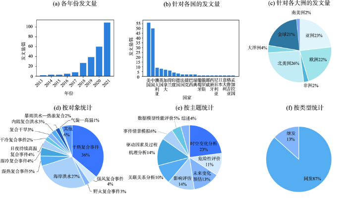
图1
2013—2021年复合极端事件研究文献分布统计
Fig.1
Statistics of the publications on compound extreme events during 2013-2021
从发文量来看,2013年(2012年IPCC SREX报告发布以来)复合极端事件的研究开始涌现,2017年之后相关文献的发表数量快速增长。从研究区域来看,全球尺度和视角的研究较多,占21%;各大洲中,亚洲、欧洲、北美洲的研究最多,分别占23%、22%和26%;区域尺度的研究主要集中于美国、中国、澳大利亚、英国等地,非洲和南美洲地区的研究相对较少。从事件类型来看,大部分研究聚焦同发型复合事件(占87%),继发型研究相对较少。从研究对象来看,现有研究主要集中于干热复合事件和雨—洪—潮沿海复合洪水事件(分别占36%和27%),湿热、湿冷事件,强风相关复合事件和昼夜持续高温事件也有一定比例的研究(4%~5%),而其他类型(包括内陆复合洪水、暴雨洪水—热浪复合事件)的研究相对较少。从研究主题来看,文献主要涵盖研究综述、时空变化分析、关联关系分析、影响评估、危险性评估、未来变化预估、驱动因素及过程机理分析、事件情景模拟和数据模型性能评价等9种类型;其中时空变化的研究文献最多(23%),驱动因素、影响评估和未来变化预估的研究近年来增加明显,成为复合极端事件研究的重要趋势。
3 复合极端事件时空关联关系诊断及建模
3.1 相关系数
3.1.1 Kendall 相关系数
Kendall相关系数是描述复合事件各因子相关性的常用指标,也是复合事件联合分布相关结构建模的重要参数[44]。它从等级排序的角度对两组序列的相关程度进行刻画,与传统Pearson相关系数相比,更适合于非线性、非正态分布的变量。
3.1.2 尾部相关系数
3.2 似然乘法因子(likelihood multiplication factor,LMF)
为研究复合事件驱动因子间的关联关系对复合事件发生概率的影响,Ridder等[45]提出了LMF指标,将其定义为观测到的复合事件发生的经验概率(
式中:
3.3 基于Copula的建模
Copula函数是由Sklar[46]在1959年提出的一种对多变量之间相关关系进行建模分析的工具。由于其具有很高的灵活性,在金融和水文等领域得到广泛的应用。
根据Sklar定理[46],假设x1, x2, …, xn为n个随机变量,其边缘分布分别为F1, F2, …, Fn,联合分布为H(x1, x2, …, xn),则存在一个Copula函数C,使得
由Sklar定理可知,Copula函数可以对各变量的任意边缘分布进行建模并构建其联合分布,通过基于Copula的联合概率建模可有效揭示变量间的相依结构[47]。
3.4 时空网络建模
复合事件多致灾因子间在时间和空间上存在复杂的耦合关联关系,从而呈现出一定的网络特性,可以通过网络建模的方法进行抽象研究。常见的方法包括贝叶斯网络、复杂网络模型等。贝叶斯网络(Bayesian network)是一种基于贝叶斯概率的有向无环图模型(directed acyclic graph),网络图中节点代表随机变量并通过有向边进行连接,有向边通过条件概率表征变量间的因果关系或条件依赖关系[55]。贝叶斯网络在刻画随机变量相依关系和事件过程的级联风险方面有广泛的应用,近年来也应用于复合事件风险的研究。Couasnon等[56]结合高斯Copula构建了贝叶斯网络模型,对美国休斯顿海湾地区洪潮复合洪水进行了模拟研究;Naseri等[57]利用基于Copula的贝叶斯网络模型,评价了美国沿海地区极端降水和高潮位复合洪水的相依关系、概率风险和不确定性特征。
复杂网络(complex network)是系统科学中的重要概念和理论,借助复杂网络的关联特性,可对极端事件的空间结构进行刻画和分析。Boers等[58]基于复杂网络理论提出事件同步性的方法和指标,揭示了全球极端降水的遥相关特征和格局;de Michele等[59]以观测站点为节点对构建了干湿二值化的降水网络,研究了欧洲和北美降水的空间关联结构。李双双等[60-61]通过复杂网络建模,研究了2008年中国南方低温雨雪冰冻灾害的演化过程和京津冀地区干旱热浪复合灾害的时空网络特征。时空网络建模的方法可以系统全面地描述复合事件多因子间的关联关系,尤其在空间复合和时间继发关系的研究方面具有显著的优势,但在复合事件大数据样本的抽象建模、网络统计特性与物理机理耦合等方面还需要更多的研究。
4 复合极端事件驱动及影响因素分析
表2 常见复合事件类型及其驱动和影响因素
Tab.2
| 复合事件类型 | 相关天气系统/驱动因素/物理机制 |
|---|---|
| 强降水与风暴潮/强风 | 热带气旋、大气河流、极端温带气旋、锋面系统、海平面上升 |
| 内陆暴雨洪涝 | 大气河流、锋面系统、季风、强对流风暴和热带气旋 |
| 高温与干旱 | 阻塞高压、大气静稳模式、副热带高压、高压脊、大气长波振荡、陆气耦合反馈作用 |
| 高温与湿润 | 高温增强大气持水能力(Clapeyron-Clausius方程),增加大气湿度 |
| 低温与干旱 | 干冷空气的寒潮、冷高压、极涡 |
| 低温与湿润 | 暴雪和冷锋系统、极涡、冷涡 |
| 日间—夜间持续高温 | 城市化、异常的反气旋、稳定的大气层结 |
| 高温热浪—暴雨洪水 | 高温增加感热通量和水汽辐合、增强大气不稳定度和暴雨强度 |
| 高温干旱森林火灾 | 大气阻塞(高温、干旱)、异常反气旋(强风)、陆气耦合反馈作用 |
一般而言,强风—暴雨相关复合事件的主要驱动因素包括热带气旋、大气河流、极端温带气旋等[63⇓-65]。热带地区主要与热带气旋相关,而中高纬度地区则主要受锋面系统和温带气旋影响[66]。如欧洲风暴潮相关复合事件主要与大规模低压系统(温带气旋)带来的大面积持续强风有关,而北美东部强降水—强风复合事件常受低压和锋面系统影响[67-68]。同时,气旋和大气阻塞系统的相互作用常导致持续的风暴潮复合洪水[69]。大气河流形成的强烈水汽输送带,往往也会带来极端的降水和大风[70]。Waliser等[71]研究发现,全球40%的海岸线上,约40%~75%的极端大风和降水事件与大气河流的登陆有关。内陆强降水和极端径流形成的复合洪水事件主要受降水因素主导,与形成强降水的多种天气系统有关,如大气河流、锋面系统、季风系统、低纬度地区的热带气旋和中小尺度强对流性天气系统等[45]。
对高温干旱复合事件物理机制的研究较为丰富,影响其发生的天气系统包括副热带高压、阻塞高压、大气静稳事件、大气长波振荡等。在副热带高压控制下,气流下沉增温导致持续的高温少雨,是造成东亚地区干热复合事件的重要原因[72]。阻塞高压和大气静稳模式使大气保持稳定少变,抑制对流运动和水汽输送,降低降水发生概率[73]。Screen等[74]研究发现北半球中纬度地区极端天气事件常伴随对流层中层显著增强的大气长波振荡,且大气长波的增强会增加北美中西部、欧洲和中亚地区干旱热浪的发生概率。高温干旱复合事件通常还受到区域陆气耦合反馈作用的影响。例如下垫面的干旱将降低蒸发蒸腾作用,增加大气饱和水汽压差,导致植被气孔关闭,蒸腾进一步减弱,抑制降水的发生;同时蒸发蒸腾减弱将增强地面接收的太阳辐射和感热通量,进一步增加地表温度[75]。此外,干旱引起的地表反照率变化也可能加剧热浪[76]。
冬季冷湿复合事件主要受强降雪系统和冷锋系统影响,如极地涡旋南下伴随冷锋系统往往给北美等高纬地区带来严重的暴雪,冷涡系统常给中国东北地区造成低温冷害和持续阴雨灾害。而冷干事件主要受冬季干冷空气的寒潮事件影响。
除特定的天气系统,复合极端事件的形成变化还受到大尺度环流因子的影响。在全球,研究发现,厄尔尼诺增强了南亚、东南亚、澳大利亚、南美北部和北美南部温度与降水之间的负相关关系,增加了这些地区干热复合事件发生的可能性[12,77]。Wu等[78]评估了大尺度环流因子对中国夏季干热复合事件的影响,发现大西洋年代际振荡(AMO)、北大西洋涛动(NAO)、太平洋年代际振荡(PDO)和ENSO的影响最为显著;Zhang等[79]分析了2019年澳大利亚高温干旱和森林火灾的海温异常,发现中太平洋厄尔尼诺和印度洋偶极子(IOD)强正向振荡的组合是该复合极端事件的重要驱动因素;Wu等[80]用海洋气候模式研究了ENSO对澳大利亚沿海极端降水和风暴潮关联关系的影响,发现拉尼娜期间大部分地区暴雨和风暴潮的关联关系会增强,增加复合洪水风险。
此外,人类活动对复合极端事件的时空变化也有重要的影响。Ma等[81]利用全球3401个气象站观测数据,对比分析了城市和农村地区日夜持续高温复合事件的特征,发现受城市热岛效应影响,城市地区复合高温事件频率、强度和持续时间均高于农村地区,且变化更为显著。在中国,Wang等[82]通过归因分析发现人为温室气体排放和城市化对日间—夜晚复合高温事件频率变化存在显著影响,两者贡献分量分别达0.51 d/10 a和1.63 d/10 a;Luo等[83]发现城市化加剧了中国东部城市地区的复合高温胁迫(高温+高湿度),城市化在极端高温胁迫频率变化中的贡献占到近30%。此外,在全球气候变化背景下,海平面上升叠加地面沉降导致海岸洪水重现期变化,也构成沿海复合洪水的重要影响因素[84-85]。
总体而言,复合极端天气气候事件通常与多种不利气象条件组合的长期稳定维持有关,其形成机制复杂多样,受到大尺度环流形势、中尺度天气系统和区域尺度陆气耦合天气过程等多方面的影响。同时人类活动在不同尺度也有不同的影响,进一步增加了其机理过程的复杂性。复合事件不同驱动因子的相互作用及不利条件组合形成的物理机制和随机特性还需要更全面更深入的研究。
5 复合极端事件危险性评估
危险性评估是支撑极端事件风险防范的重要基础,传统针对单变量极端事件的评估方法很多并不适用于复合事件,因此,有研究提出或改进了针对多变量复合事件的危险性评估方法。
5.1 基于超越概率和重现期的频率分析方法
5.1.1 “且”“或”联合重现期
以
“且”重现期
研究三变量乃至更多变量事件的重现期时,可利用Vine Copula构建高维联合分布模型,将“且”“或”重现期扩展到高维[54]。
变量X、Y和Z的“或”重现期为:
变量X、Y和Z的“且”重现期为:
5.1.2 Kendall重现期和Survival Kendall重现期
图2
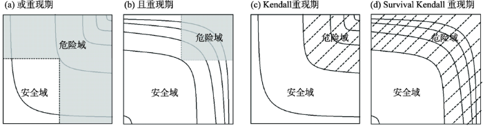
图2
不同重现期情景安全域和危险域示意图
注:灰色部分及斜线阴影部分为危险域,白色部分为安全域。曲线为不同重现期的等值线。
Fig.2
Illustration of the safe and hazardous areas of bivariate extreme events under different recurrence scenarios
Kendall重现期
Survival Kendall重现期
式中:
5.1.3 条件重现期
对多变量复合事件,在某些情况下需要根据部分变量情况推测其余变量的可能分布,此时可以结合条件概率,计算条件重现期[54]。
X在给定Y和Z条件下的重现期为:
X、Y在给定Z条件下的重现期为:
式中:
5.1.4 年均可靠度(average annual reliability,AAR)
式中:
基于超越概率和重现期的频率分析方法可有效揭示复合事件的复杂概率特征,其中,“且”、“或”、Kendall和Survival Kendall重现期刻画了不同情景的联合概率;条件重现期适用于根据部分变量情况推测其余变量可能分布的情况;AAR方法可以对气候变化等非平稳条件下的极端事件概率风险进行评估。考虑复合事件的极端性,上述基于概率的方法需要有较长序列的观测数据,同时不同取样方法和分布型的选取也会带来一定的不确定性。
5.2 基于数值模拟的情景分析方法
除了基于联合概率分布的强度—频率分析,也有研究从复合事件致灾过程情景模拟的角度开展危险性评价。这类研究主要针对沿海“雨—洪—潮”复合洪水以及内陆河流上下游和干支流遭遇洪水,结合水文模型、水动力学模型、海浪和风暴潮海洋模式等多种数值模型,对不同遭遇情景下的洪水演进过程和淹没特征进行模拟分析。如王璐阳等[94]考虑了风暴增水、极端暴雨、天文高潮、上游洪水和波浪等因素,使用大气—海洋—陆地相耦合的一体化风暴洪水淹没模拟方法,对上海市风、暴、潮、洪多灾种并发的复合极端风暴洪水的演进和淹没特征进行了模拟;Saharia等[95]结合Copula和条件概率与水文模型,模拟了不同下游水位条件下,上游河流径流的变化,并进行了不同遭遇情景下的淹没模拟。与单过程事件相比,复合洪水的情景分析需要涉及多个过程多类模型的耦合模拟。方佳毅等[88]对沿海复合洪水数值模拟的模型类型、模型耦合方式和特征进行了较为系统的梳理总结。
基于数值模拟的分析方法可有效刻画复合事件的致灾过程和致灾情景。近年来复合洪水模拟的相关模型不断发展,其中的水文模型从集总式发展到半分布式和分布式,日益丰富,水动力学模型从一维向二维、三维不断扩展,海洋数值模式的模拟精细度也在不断提高,模型耦合方式从单向型向松散耦合型和紧密耦合型发展。但当前研究仍存在一定挑战,如多模型耦合建模过程复杂,运算量大,模拟的精细度和计算及时间成本之间的矛盾需要更优的协调策略;此外对复合因子相互作用过程刻画不足以及模型耦合程度有限导致模拟不确定性累积,也需要进一步改进。
6 研究展望与结论
6.1 未来研究展望
近年来复合极端事件的研究取得了较为显著的进展,但其更深入的研究仍面临一系列挑战,建议未来研究可在以下几个方面进行深化。
图3
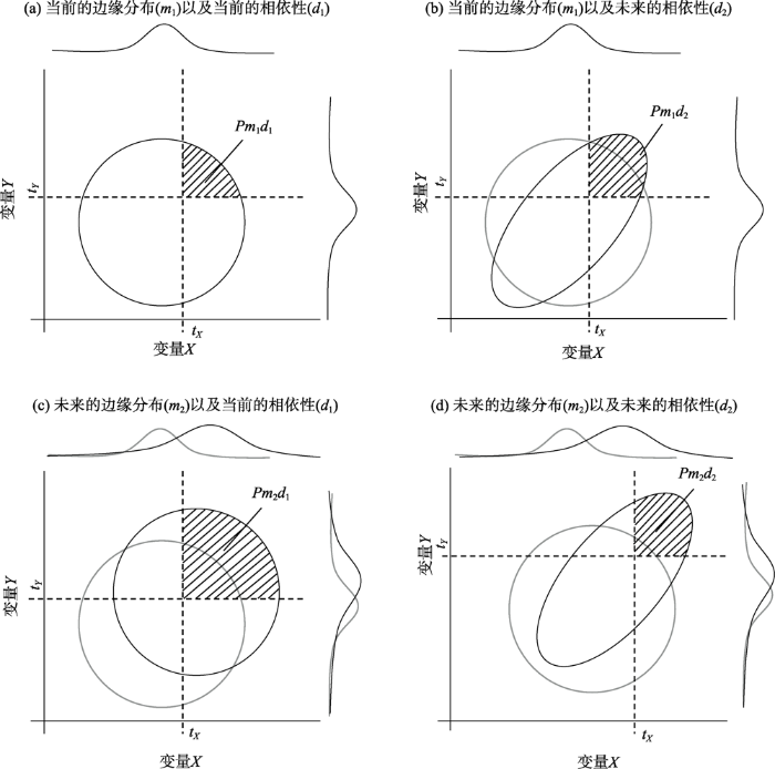
图3
边缘分布和相依结构变化对复合事件联合超越概率变化影响示意图[52]
注:灰色及黑色曲线分别表示变化前和变化后概率分布,阴影部分代表超过阈值的极端事件的组合;P代表极端事件发生的概率;tX、tY分别代表变量X和变量Y的阈值。
Fig.3
Illustration for the influence of marginal distribution and dependence variations on joint exceedance probability
(3) 当前研究多从水文气象角度关注复合极端事件的发生过程及可能性,缺乏与风险评估和管理决策的有效衔接。复合极端灾害形成机制复杂,致灾组合具有较高的不确定性,同一概率水平下的不同事件组合可造成不同的影响,给风险评估与防范带来严峻挑战。传统基于事件概率和损失模拟自上而下的风险评估框架难以全面刻画真实的风险水平。对此,有学者提出自下而上基于故事线(story-line)的分析框架[3],但仍难以在实际研究中有效应用。未来应进一步加强复合极端事件危险性评价与风险评估管理的衔接,通过多情景多模式的耦合模拟,优化危险性的表达方式,更全面地刻画复合事件的危险性特征;同时应进一步加强复合事件模式模拟、情景分析、概率组合等方面的不确定性分析,量化不同致灾组合的不确定性水平。
6.2 结论
近年来,复杂多过程的复合极端事件受到越来越多的关注,同时伴随全球变化和灾害风险科学的发展,对极端事件的认识不断加深,复合极端事件的研究不断丰富,取得了一系列的进展。
(1) 从研究对象来看,研究的事件类型越来越丰富,极端气温—降水—风—径流—风暴潮等不同要素组合,以及同发、继发、同地、异地不同组合类型的复合事件的研究不断涌现,极大地加深了对极端天气气候事件的认识,也丰富了多灾种和灾害复杂性的研究。
(2) 从研究内容体系来看,近年来复合极端事件的研究快速发展,初步建立了较为完整的研究体系。其中,复合事件概念和特征分类的理论研究逐步完善;时空关联关系的研究较为丰富,但在复杂相依结构(如复杂网络关系)方面还有待更深入的探究;事件成因及驱动因素的研究不断增加,但主要集中于事件过程的天气系统分析和大尺度环流因子的相关关系分析,对多因子相互作用机理及人类活动影响的研究相对不足;在复合极端事件评估方面,围绕基于联合概率的危险性分析和基于情景模拟的影响评估也开展了一定的研究。
(3) 从研究技术手段来看,刻画时空关联关系和多维联合概率的各类数理统计方法不断发展,其中以Copula模型为核心的联合概率建模得到越来越广泛的应用,并实现了由二维向多维、由静态向动态建模的发展。此外,针对复合洪水,耦合水文模型、水动力学模型和海洋风暴潮模式的数值模拟方法也不断发展,模拟的精细度不断提高,在一定程度上满足了复合洪水过程模拟和淹没影响评价的需要。
未来应进一步加强时间继发性和空间复合型事件复杂时空关联关系的研究,深化不同时空尺度多致灾因子耦合作用的认识。同时,需要进一步深化气候变化背景下复合事件变化的归因研究,关注单变量边缘分布变化及相依结构变化对复合事件非平稳变化的影响。此外,未来应加强复合事件致灾组合情景刻画及不确定性的研究,推动复合事件危险性评价与风险评估管理的衔接。
参考文献
How climate change affects extreme weather events
[J].
DOI:10.1126/science.aaf7271
URL
[本文引用: 1]

Research can increasingly determine the contribution of climate change to extreme events such as droughts
气候变化风险及其定量评估方法
[J].
DOI:10.18306/dlkxjz.2018.01.004
[本文引用: 1]
风险评估是气候变化研究领域的核心课题之一,减缓和适应战略的理论需求推动下发展出许多定量评估方法,完成了大量的评估工作。然而,已有研究在气候变化的风险构成上从不同的角度去认识,且评估方法论在整体上缺乏对致险因子与承险体的集成分类。基于此,本文明晰气候变化风险构成,包括致险因子的危险性、承险体的暴露度与脆弱度及其相互关系,明晰了风险产生与变化逻辑。融合致险因子与承险体特征,将气候变化风险定量评估方法归纳为突发事件和渐变事件两类,并分别进行了理论阐述和案例剖析。最后,根据气候变化风险的研究现状和评估需求,从温升目标、脆弱性曲线、适应措施等方面提出未来展望。
Climate change risk and methodology for its quantitative assessment
DOI:10.18306/dlkxjz.2018.01.004
[本文引用: 1]
Risk assessment is a core area of climate change research. Quantitative assessment methods have been developed particularly due to the needs for theory of mitigation and adaptation strategies, and have been applied to a great number of specific assessments. However, there have been different viewpoints of the risk composition of climate change, and overall, integrated classification by coupling risk causing factors and risk bearing bodies is lacking. This article illuminates the risk composition of climate change, including the danger of risk causing factors, the exposure and vulnerability of risk bearing bodies, and their interrelations. The emergence and change of risk were clarified. Based on the integrated analysis of risk causing factors and risk bearing bodies, this study divided the climate change risk quantitative assessment methods into sudden onset hazard risk and slow onset hazard risk assessment methods, then the theoretical elaboration and case analysis were conducted for the two types of risks respectively. Finally, according to the current status and needs, this article proposes the future development directions of climate change risk research, including risk assessment under different warming amplitude, vulnerability curve construction, and adaptation.
Future climate risk from compound events
[J].DOI:10.1038/s41558-018-0156-3 [本文引用: 3]
Global warming and changes in risk of concurrent climate extremes: Insights from the 2014 California drought
[J].DOI:10.1002/2014GL062308 URL [本文引用: 1]
Dependence of drivers affects risks associated with compound events
[J].
A compound event framework for understanding extreme impacts
[J].DOI:10.1002/wcc.2014.5.issue-1 URL [本文引用: 3]
Managing the risks of extreme events and disasters to advance climate change adaptation: A special report of working groups I and II of the Intergovernmental Panel on Climate Change
[R].
关于复合型极端事件的新认识和启示
[J].
Advances in scientific understanding on compound extreme events
A review of quantification methodologies for multi-hazard interrelationships
[J].
灾害系统: 灾害群、灾害链、灾害遭遇
[J].
Disaster system: Disaster cluster, disaster chain and disaster compound
Quantifying the relationship between compound dry and hot events and El Niño-Southern Oscillation (ENSO) at the global scale
[J].DOI:10.1016/j.jhydrol.2018.10.022 URL [本文引用: 2]
The hazardousness of a place: A regional ecology of damaging events
[J].DOI:10.2307/213252 URL [本文引用: 1]
再论灾害研究的理论与实践
[J].
Theory and practice of disaster study
A typology of compound weather and climate events
[J].
Causes, impacts and patterns of disastrous river floods
[J].
A framework for complex climate change risk assessment
[J].DOI:10.1016/j.oneear.2021.03.005 URL [本文引用: 1]
Climate change and changes in compound coastal-riverine flooding hazard along the U.S. coasts
[J].
The role of intensifying precipitation on coastal river flooding and compound river-storm surge events, Northeast Gulf of Mexico
[J].
Understanding the impacts of predecessor rain events on flood hazard in a changing climate
[J].
Growing threats from unprecedented sequential flood-hot extremes across China
[J].
Higher probability of occurrence of hotter and shorter heat waves followed by heavy rainfall
[J].
Compound hazards yield Louisiana flood
[J].
Quantifying effects of compound dry-hot extremes on vegetation in Xinjiang (China) using a vine-Copula conditional probability model
[J].
Spatial and temporal variations of compound droughts and hot extremes in China
[J].Droughts and hot extremes may lead to tremendous impacts on the ecosystem and different sectors of the society. A variety of studies have been conducted on the variability of the individual drought or hot extreme in China. However, the evaluation of compound droughts and hot extremes, which may induce even larger impacts than the individual drought or hot extreme, is still lacking. The aim of this study is to investigate changes in the frequency and spatial extent of compound droughts and hot extremes during summer in China using monthly precipitation and daily temperature data from 1953 to 2012. Results show that a high frequency of compound droughts and hot extremes mostly occur in the regions stretching from northeast to southwest of China. There is an overall increase in the frequency of co-occurrence of droughts and hot extremes across most parts of China with distinct regional patterns. In addition, an increasing trend in the areas covered by compound extremes has been observed, especially after the 1990s. At regional scales, the increase of the frequency and spatial extent of compound extremes has been shown to be most profound in North China (NC), South China (SC), and Southwest China (SWC), while the decrease of compound extremes was found in Central China (CC). These results show the variability of compound droughts and hot extremes and could provide useful insights into the mitigation efforts of extreme events in China.
The record-breaking compound hot and dry 2018 growing season in Germany
[J].
Compound warm-dry and cold-wet events over the Mediterranean
[J].
DOI:10.5194/esd-11-793-2020
URL
[本文引用: 1]
. The Mediterranean (MED) Basin is a climate change hotspot that has seen drying and a pronounced increase in heatwaves over the last century. At the same time, it is experiencing increased heavy precipitation during wintertime cold spells. Understanding and quantifying the risks from compound events over the MED is paramount for present and future disaster risk reduction measures. Here, we apply a novel method to study compound events based on dynamical systems theory and analyse compound temperature and precipitation events over the MED from 1979 to 2018. The dynamical systems analysis quantifies the strength of the coupling between different atmospheric variables over the MED. Further, we consider compound warm–dry anomalies in summer and cold–wet anomalies in winter. Our results show that these warm–dry and cold–wet compound days are associated with large values of the temperature–precipitation coupling parameter of the dynamical systems analysis. This indicates that there is a strong interaction between temperature and precipitation during compound events. In winter, we find no significant trend in the coupling between temperature and precipitation. However in summer, we find a significant upward trend which is likely driven by a stronger coupling during warm and dry days. Thermodynamic processes associated with long-term MED warming can best explain the trend, which intensifies compound warm–dry events.\n
Likelihood of concurrent climate extremes and variations over China
[J].
Clustering bivariate dependencies of compound precipitation and wind extremes over Great Britain and Ireland
[J].
Evaluating the dependence structure of compound precipitation and wind speed extremes
[J].
DOI:10.5194/esd-12-1-2021
URL
[本文引用: 3]
. Estimating the likelihood of compound climate extremes such as concurrent drought and heatwaves or compound precipitation and wind speed extremes is important for assessing climate risks. Typically, simulations from climate models are used to assess future risks, but it is largely unknown how well the current generation of models represents compound extremes. Here, we introduce a new metric that measures whether the tails of bivariate distributions show a similar dependence structure across different datasets. We analyse compound precipitation and wind extremes in reanalysis data and different high-resolution simulations for central Europe. A state-of-the-art reanalysis dataset (ERA5) is compared to simulations with a weather model (Weather Research and Forecasting – WRF) either driven by observation-based boundary conditions or a global circulation model (Community Earth System Model – CESM) under present-day and future conditions with strong greenhouse gas forcing (Representative Concentration Pathway 8.5 – RCP8.5).\nOver the historical period, the high-resolution WRF simulations capture precipitation and wind extremes as well as their response to orographic effects more realistically than ERA5. Thus, WRF simulations driven by observation-based boundary conditions are used as a benchmark for evaluating the dependence structure of wind and precipitation extremes.\nOverall, boundary conditions in WRF appear to be the key factor in explaining differences in the dependence behaviour between strong wind and heavy precipitation between simulations. In comparison, external forcings (RCP8.5) are of second order. Our approach offers new methodological tools to evaluate climate model simulations with respect to compound extremes.\n
上海中心城区复合洪涝淹没模拟及未来重现预估
[J].
Compound flooding simulation and prediction of future recurrence in Shanghai downtown area
Compound flood potential from storm surge and heavy precipitation in coastal China: Dependence, drivers, and impacts
[J].
DOI:10.5194/hess-25-4403-2021
URL
[本文引用: 1]
. The interaction between storm surge and concurrent precipitation is poorly understood in many coastal regions. This paper investigates the potential compound effects from these two flooding drivers along the coast of China for the first time by using the most comprehensive records of storm surge and precipitation. Statistically significant dependence between flooding drivers exists at the majority of locations that are analysed, but the strength of the correlation varies spatially and temporally and depending on how extreme events are defined. In general, we find higher dependence at the south-eastern tide gauges (TGs) (latitude < 30∘ N) compared to the northern TGs. Seasonal variations in the dependence are also evident. Overall there are more sites with significant dependence in the tropical cyclone (TC) season, especially in the summer. Accounting for past sea level rise further increases the dependence between flooding drivers, and future sea level rise will hence likely lead to an increase in the frequency of compound events. We also find notable differences in the meteorological patterns associated with events where both drivers are extreme versus events where only one driver is extreme. Events with both extreme drivers at south-eastern TG sites are caused by low-pressure systems with similar characteristics across locations, including high precipitable water content (PWC) and strong winds that generate high storm surge. Based on historical disaster damages records of Hong Kong, events with both extreme drivers account for the vast majority of damages and casualties, compared to univariate flooding events, where only one flooding driver occurred. Given the large coastal population and low capacity of drainage systems in many Chinese urban coastal areas, these findings highlight the necessity to incorporate compound flooding and its potential changes in a warming climate into risk assessments, urban planning, and the design of coastal infrastructure and flood defences.
Increasing risk of compound flooding from storm surge and rainfall for major US cities
[J].
DOI:10.1038/NCLIMATE2736
[本文引用: 2]
Wahl, Thomas; Meyers, Steven D.; Luther, Mark E. Univ S Florida, Coll Marine Sci, St Petersburg, FL 33701 USA. Wahl, Thomas; Bender, Jens Univ Siegen, Res Ctr Siegen, D-57076 Siegen, Germany. Jain, Shaleen Univ Maine, Climate Change Inst, Civil & Environm Engn, Orono, ME 04469 USA. Jain, Shaleen Univ Maine, Mitchell Ctr Sustainabil Solut, Orono, ME 04469 USA. Bender, Jens Univ Siegen, Res Inst Water & Environm, D-57076 Siegen, Germany.
Climate change effects on hydrometeorological compound events over southern Norway
[J].
Increasing exposure of energy infrastructure to compound hazards: Cascading wildfires and extreme rainfall
[J].Floods and debris flows pose a significant threat, especially when extreme rain falls over burned areas. This is an example of a compound event in which two concurrent or consecutive events lead to extreme societal impacts. Compound and cascading hazards are becoming increasingly important and have notable impacts on threatened communities across the world. Wildfire followed by an intense precipitation event can result in a large flood under which the combined impacts of hazard drivers are much more intense than those from individual drivers. Here, we first quantify the change in exposure of natural gas infrastructure to individual hazards, wildfire and floods in the future relative to past. We, then quantify the compound hazards as coincidence likelihood of intense rain over burned areas and analyze the spatial patterns across the State of California, USA. Our results show that not only the exposure of natural gas infrastructure to individual hazards would be higher, the likelihood of compound hazards is expected to increase substantially in a warming climate.
Mechanisms for regional compound hot extremes in the mid-lower reaches of the Yangtze River
[J].DOI:10.1002/joc.v41.2 URL [本文引用: 1]
Different mechanisms for daytime, nighttime, and compound heatwaves in Southern China
[J].
1960—2018年中国西南地区旱涝急转的时空变化特征
[J].
DOI:10.13249/j.cnki.sgs.2021.12.016
[本文引用: 1]
基于 1960—2018 年的逐日降水观测数据,采用日尺度旱涝急转指数(DWAAI)计算方法,以生态地理区为框架,识别并分析了西南地区旱涝急转事件的时空变化特征。结果表明:西南地区旱涝急转事件的发生次数在 1960—2010年有增加趋势,在 2011—2018 年快速减少;旱转涝事件多发生在春夏季(4~8 月),涝转旱事件则跨越了春、夏、秋季(5~11 月);在云南高原常绿阔叶林、松林区(VA5),西双版纳山地季雨林、雨林区(VIIA3),闽粤桂低山平原常绿阔叶林、人工植被区(VIA2),旱涝急转事件主要发生在夏季,而在湘黔高原山地常绿阔叶林区(VA3)和四川盆地常绿阔叶林、人工植被区(VA4),旱涝急转事件主要发生在春季;旱涝急转事件发生次数的空间分布呈现东北多、西南少的格局;2000 年以来旱涝急转事件在滇中南亚高山谷地常绿阔叶林、松林区(VIA3)和闽粤桂低山平原常绿阔叶林、人工植被区(VIA2)发生次数减少,但有加重趋势,呈现极端化特征。
Spatio-temporal characteristics of drought-flood abrupt alternation in the Southwest China from 1960 to 2018
DOI:10.13249/j.cnki.sgs.2021.12.016
[本文引用: 1]
With the warming climate and enhancing human activities, the frequency and intensity of dry-wet abrupt alternation (DWAA) events have been increasing, largely affected on natural environment and social-economy development. Using observed daily precipitation from 1960 to 2018, this study analyzed the spatio-temporal variations of DWAA events in Southwest China by calculating Dry-Wet Abrupt Alternation Index (DWAAI) based on eco-geographical regions. The DWAA events in Southwest China exhibited an increasing trend before 2010 and decreased after 2011. The dry-to-wet events mainly concentrated in spring and summer (April to August). Meanwhile, the wet-to-dry events were primarily found in spring, summer and autumn (May to November). At seasonal scale, DWAA events mainly occurred in summer, distributed in the area of Yunnan Plateau evergreen broadleaved forest and pine forest region (VA5), Xishuangbanna mountains seasonal rainforest and rainforest region (VIIA3), and Fujian, Guangdong and Guangxi low mountain and plain evergreen broadleaved forest and cultivated vegetation region (VIA2). In the area of Hunan and Guizhou mountains evergreen broadleaved forest region (VA3), and Sichuan Basin evergreen broadleaved forest and cultivated vegetation region (VA4), the DWAA events were examined in spring. Spatially, majority of DWAA events existed in the northeast of Southwest China, and the less were found in the southwest. Although frequency of DWAA events declined since 2000, the intensity of DWAA was obviously enhanced, especially in Xishuangbanna mountains seasonal rainforest and rainforest region (VIIA3), and Fujian, Guangdong and Guangxi low mountain and plain evergreen broadleaved forest and cultivated vegetation region (VIA2).
Synchronous crop failures and climate-forced production variability
[J].
Increasing concurrent drought probability in global main crop production countries
[J].
The 2010 Pakistan flood and Russian heat wave: Teleconnection of hydrometeorological extremes
[J].
DOI:10.1175/JHM-D-11-016.1
URL
[本文引用: 1]
In this paper, preliminary results are presented showing that the two record-setting extreme events during 2010 summer (i.e., the Russian heat wave–wildfires and Pakistan flood) were physically connected. It is found that the Russian heat wave was associated with the development of an extraordinarily strong and prolonged extratropical atmospheric blocking event in association with the excitation of a large-scale atmospheric Rossby wave train spanning western Russia, Kazakhstan, and the northwestern China–Tibetan Plateau region. The southward penetration of upper-level vorticity perturbations in the leading trough of the Rossby wave was instrumental in triggering anomalously heavy rain events over northern Pakistan and vicinity in mid- to late July. Also shown are evidences that the Russian heat wave was amplified by a positive feedback through changes in surface energy fluxes between the atmospheric blocking pattern and an underlying extensive land region with below-normal soil moisture. The Pakistan heavy rain events were amplified and sustained by strong anomalous southeasterly flow along the Himalayan foothills and abundant moisture transport from the Bay of Bengal in connection with the northward propagation of the monsoonal intraseasonal oscillation.
Correlations between extreme atmospheric hazards and global teleconnections: Implications for multihazard resilience
[J].DOI:10.1002/rog.v56.1 URL [本文引用: 1]
河套气旋发展东移对一次北京特大暴雨的触发作用
[J].
DOI:10.7522/j.issn.1000-0534.2014.00029
[本文引用: 1]
利用气象站观测资料和NCEP/NCAR再分析资料对河套气旋发展东移触发的北京2012年7月21日特大暴雨(下称"721"暴雨)天气过程进行了诊断分析, 结果表明: 河套气旋是北京"721"特大暴雨的主要影响系统, 内蒙中部较强的冷空气活动阻挡了河套气旋北上的常规路径, 迫使其东移直接影响河北、北京地区; 河套气旋在东移过程中, 由暖心正压气旋转变为斜压性气旋, 且强烈发展, 其水汽、热力、高低空急流耦合等条件随着河套气旋的东移明显好转, 是此次暴雨天气过程降水量自西向东不断增大的主要原因; 午后, 河套气旋东移暖锋触发不稳定能量释放, 在北京地区产生强对流系统, 形成中尺度对流辐合体后, 使得降水进一步加强, 是北京地区产生特大暴雨的主要原因; 东南气流中地形抬升作用对降水有增幅作用, 北京"721"特大暴雨是多种有利因素叠加所致。
Analysis of Hetao cyclone shifting eastward and producing rainstorm process in Beijing
DOI:10.7522/j.issn.1000-0534.2014.00029
[本文引用: 1]
The rainstorm process on 21 July 2012(hereafter ‘721’ process) in Beijing is analyzed produced by the Hetao cyclone shifting eastward. The results show that the Hetao cyclone moves eastward directly that leads to the ‘721’ process, because the path of Hetao cyclone shifting northward is blocked by the stronger cold air. The main reason that the precipitation increases from west to east is because of the increasing factors, for example, the vapor, heat and high-low level jet stream during the warm barotropic cyclone changes into baroclinic cyclone with the process of Hetao cyclone shifting eastward. Afternoon, the instability energy triggers and the strong convective system forms in Beijing, whenthe warm front moves eastward. The formation of mesoscale convective complex (MCC)thatmakes the precipitation strengthened further, which is the main reason of the heavy rainstormin Beijing. The topography acts as a stimulus to this precipitation and the ‘721’ process is formed under simultaneous multiple positive factors.
Compound events under global warming: A dependence perspective
[J].
Global hotspots for the occurrence of compound events
[J].Compound events (CEs) are weather and climate events that result from multiple hazards or drivers with the potential to cause severe socio-economic impacts. Compared with isolated hazards, the multiple hazards/drivers associated with CEs can lead to higher economic losses and death tolls. Here, we provide the first analysis of multiple multivariate CEs potentially causing high-impact floods, droughts, and fires. Using observations and reanalysis data during 1980-2014, we analyse 27 hazard pairs and provide the first spatial estimates of their occurrences on the global scale. We identify hotspots of multivariate CEs including many socio-economically important regions such as North America, Russia and western Europe. We analyse the relative importance of different multivariate CEs in six continental regions to highlight CEs posing the highest risk. Our results provide initial guidance to assess the regional risk of CE events and an observationally-based dataset to aid evaluation of climate models for simulating multivariate CEs.
Fonctions de repartition a n dimensions et leursmarges
[J].
Copula函数在多变量水文分析计算中的应用及研究进展
[J].
Multivariate hydrological analysis and estimation
Review of dependence modeling in hydrology and water resources
[J].
DOI:10.1177/0309133316632460
URL
[本文引用: 2]
Various methods have been developed over the past five decades for dependence modeling of multivariate variables in hydrology and water resources, but there has been no overall review of techniques commonly used in the field. This paper, therefore, introduces several methods focusing on dependence structure modeling, including parametric distribution, entropy, copula, and nonparametric. Recent advances in modeling dependences mainly reside in nonlinear dependence modeling (including extreme dependence) with flexible marginal distributions, and in high-dimension dependence modeling via the vine copula construction with flexible dependence structures. Strengths and limitations of different methods and avenues for future research, such as dependence modeling in a changing climate, are discussed to aid water resource planners and managers in the selection and application of suitable techniques.
基于混合Copula模型的灾害相关结构分析: 以内蒙古中部强沙尘暴为例
[J].
Dependence analysis of disaster based on mixed Copula model: A case study of the severe dust storm disaster in central Inner Mongolia
气候变化影响下极端水文事件的多变量统计模型研究
[J].
The multi-variable statistical models of extreme hydrological events under climate change
Copula函数在水文水资源中的研究进展与述评
[J].
Application of Copula functions in hydrology and water resources: A state-of-the-art review
Time of emergence of compound events: Contribution of univariate and dependence properties
[J].
基于Copula函数的汉江中上游流域极端降雨洪水联合分布特征
[J].
Joint distribution of the extreme rainfall and flood for the upper-middle reaches of the Hanjiang River based on Copula function
Multivariate modeling of flood characteristics using Vine Copulas
[J].
Overview on Bayesian networks applications for dependability, risk analysis and maintenance areas
[J].DOI:10.1016/j.engappai.2010.06.002 URL [本文引用: 1]
A Copula-based Bayesian network for modeling compound flood hazard from riverine and coastal interactions at the catchment scale: An application to the Houston ship channel, Texas
[J].Traditional flood hazard analyses often rely on univariate probability distributions; however, in many coastal catchments, flooding is the result of complex hydrodynamic interactions between multiple drivers. For example, synoptic meteorological conditions can produce considerable rainfall-runoff, while also generating wind-driven elevated sea-levels. When these drivers interact in space and time, they can exacerbate flood impacts, a phenomenon known as compound flooding. In this paper, we build a Bayesian Network based on Gaussian copulas to generate the equivalent of 500 years of daily stochastic boundary conditions for a coastal watershed in Southeast Texas. In doing so, we overcome many of the limitations of conventional univariate approaches and are able to probabilistically represent compound floods caused by riverine and coastal interactions. We model the resulting water levels using a one-dimensional (1D) steady-state hydraulic model and find that flood stages in the catchment are strongly affected by backwater effects from tributary inflows and downstream water levels. By comparing our results against a bathtub modeling approach, we show that simplifying the multivariate dependence between flood drivers can lead to an underestimation of flood impacts, highlighting that accounting for multivariate dependence is critical for the accurate representation of flood risk in coastal catchments prone to compound events.
A Bayesian Copula-based nonstationary framework for compound flood risk assessment along US coastlines
[J].
Complex networks reveal global pattern of extreme-rainfall teleconnections
[J].DOI:10.1038/s41586-018-0872-x [本文引用: 1]
Dependence types in a binarized precipitation network
[J].
2008年中国南方低温雨雪冰冻灾害网络建模及演化机制研究
[J].
DOI:10.11821/dlyj201510007
[本文引用: 1]
基于中国0.5°×0.5°逐日气温和降水格网数据,利用复杂网络分析方法,对2008年南方低温雨雪冰冻灾害综合致灾过程进行再认识,综合分析低温雨雪冰冻灾害在时空维度的网络特性。结果表明:2008年南方低温雨雪冰冻灾害是典型的多灾种叠加事件,低温与雨雪灾害叠加放大了致灾因子的危险性;基础设施设防水平低与春运高峰叠加增大了承灾体的脆弱性;低山丘陵区与人口聚集区叠加降低了孕灾环境的稳定性。低温冰冻雨雪灾害具有小世界特征和核心—边缘结构,具体表现为:在空间打击上具有集聚性,影响区域相对集中;在时间打击上具有连续性,间隔1天事件相对较少。在研究方法上,复杂网络是一种有效分析多灾种叠加的方法,可以进一步挖掘自然灾害的时空演化信息。
Network modeling and dynamic mechanisms of the severe cold surge, ice-snow events, and frozen disasters in Southern China in 2008
DOI:10.11821/dlyj201510007
[本文引用: 1]
In recent years, some new areas of development have been proposed for natural disaster science. It is suggested that the discipline should try to attach more importance to recognizing disaster loss accumulation and amplification trends, re-evaluate the mechanisms of major natural disasters, and facilitate interdisciplinary research between natural disaster and complexity science. The 2008 Chinese ice storm struck the most populated and economically developed region of China, and direct economic losses exceeded $22.3 billion (indirect losses may have been even greater). Recognition of the formation mechanism of the 2008 Chinese ice storm will be very important for developing integrated disaster risk reduction strategies. This study employed daily temperature and precipitation data from a 0.5°×0.5° gridded dataset released by China's National Meteorological Information Center to evaluate the synthetic hazard process of the severe cold surge, ice-snow events, and corresponding frozen disasters in southern China in 2008. More specifically, we analyzed the spatial-temporal structure and complexity of the catastrophes by using bipartite networks. Results indicated that the large freezing rain and snow disaster was a typical multi-disaster overlaying event. The overlaying of freezing rain and snow amplified the risks of other hazards such as critical infrastructure failures. Moreover, the timing of the event, which occurred during the Chinese New Year, increased the vulnerability of people to exposures (i.e., they were more likely to be traveling). Low mountain-hilly terrain and high population density reduced the stability of the fostering environment. The freezing rain and snow catastrophes in 2008 showed the mathematical characteristics of small-world features. In terms of spatial data, the occurrence of hazards was clustered when the unprecedented ice struck the region; in terms of temporal data, the intervals between successive waves were too short for ice to melt or be broken, thus disaster losses were accumulated and amplified through the small-world features of the hazards. Networks of freezing rain and snow catastrophes in 2008 had a typical core-periphery structure. The spatial core nodes were Sichuan, Guizhou, Chongqing, Anhui, Hubei, Shaanxi, and Hunan (provincial units); the temporal core nodes were 1.13, 1.15, 1.17-1.22, and 1.25-2.4. Overall, these results highlight that complex network theory can be used advantageously in the analysis of the loss accumulation and amplification trends associated with multi-disaster events. Such techniques can also be used effectively to describe the spatial and temporal evolution of multi-disaster events and support the understanding of disaster dynamics.
面向非过程的多灾种时空网络建模: 以京津冀地区干旱热浪耦合为例
[J].
DOI:10.11821/dlyj201708002
[本文引用: 1]
干旱和热浪耦合是典型的多灾种事件,全球气候变暖增加了干旱和热浪耦合的风险。选取京津冀地区作为研究对象,以复杂网络理论为基础,构建干旱热浪时空耦合网络模型,拓展派系模型时空聚类方法,分析年代尺度上干旱和热浪时空聚类特征。结果表明:近55年京津冀地区干旱热浪耦合存在空间差异性,形成4个规律相异的时空耦合形态,即密集分布型(张家口—怀来—遵化,石家庄—邢台)、前期集中型(北部燕山地区)、后期集中型(太行山地区)、稀疏分布型(东部沿海区)。同时,干旱热浪空间耦合中心具有明显的迁移规律,以20世纪80年代为界,前期耦合中心分布偏北,位于北部燕山地区,后期则向南迁移,分布于南部太行山区。以时空数据为基础,提出面向非过程的多灾种时空网络构建方法,不仅是多灾种研究方法的探索,也是地理时空数据一体化研究的尝试,以期为多灾种时空耦合方法体系完善提供新的思路。
Spatiotemporal network modeling in concurrent heat waves and droughts in the Beijing-Tianjin-Hebei metropolitan region, China
DOI:10.11821/dlyj201708002
[本文引用: 1]
Concurrent occurrence of heat waves and droughts is a typical multi-hazard event. Global warming is leading to an increased risk of concurrent and compound extremes. In this study, we evaluated the changes in the pattern of concurrent drought and heat wave events in the Beijing-Tianjin-Hebei metropolitan region, China from 1960 to 2014. In addition, we used spatial-temporal data as a breakthrough point to examine the spatiotemporal clustering in concurrent heat wave and drought events by using bipartite networks. According to our results, based on the variations in heat waves and droughts trends, three distinct phases were identified: the first phase (1960s-1970s), a relatively wet phase when heat waves continually decreased; the second phase (1980s-1990s), when the climate conditions changed from a drought like period to a pluvial period, and the heat waves increased; the third phase (1999-2014), when little precipitation was observed and the heat waves showed a decreasing trend. The correlation between heat waves and droughts was found to increase substantially between 1960 and 2014. Moreover, the concurrence of heat waves and droughts showed a significant pattern of spatiotemporal variation; before 1984, the concurrence of heat waves and droughts increased in the surrounding regions and the north of Yanshan Mountains; after 1984, high concurrence between heat waves and droughts was mainly observed in the south of Taihang Mountains. The research methodology used in this study can not only serve as the basis for research on multi-hazards, but also contribute to geographic spatiotemporal data modeling. Most importantly, the method based on the spatiotemporal network for multi-hazards makes up for the deficiencies of traditional methods in terms of utilization of spatiotemporal data.
Compound hydrometeorological extremes: Drivers, mechanisms and methods
[J].
A review of historical and future changes of extratropical cyclones and associated impacts along the US east coast
[J].
DOI:10.1007/s40641-015-0013-7
PMID:32025470
[本文引用: 1]
This paper reviews the historical and potential future trends of extratropical cyclones (ECs) along the United States (US) East Coast and western Atlantic, as well as potential changes in coastal flooding, heavy precipitation, and damaging winds. Most models project a steady decrease in the number of ECs for the US East Coast and western Atlantic region by the middle to later twenty-first century, while there is an increase in more intense (<980 hPa) cyclones and heavy precipitation; however, there is also been large interdecadal and interannual variability. Potential biases may exist in the models because of difficulty capturing: (a) the Atlantic storm track sensitivity to the Gulf Stream SST gradient, (b) latent heating within these storms, and (c) dynamical interactions at jet level. More work is needed to determine future changes in hybrid storms (e.g., Sandy 2012) and diagnostics to better understand the future cyclone changes in the models.© The Author(s) 2015.
Storm surges from extra-tropical cyclones
[J].DOI:10.1023/B:NHAZ.0000031312.98231.81 URL [本文引用: 1]
Storm surge return levels induced by mid-to-late-twenty-first-century extratropical cyclones in the Northeastern United States
[J].DOI:10.1007/s10584-019-02431-8 [本文引用: 1]
A global quantification of compound precipitation and wind extremes
[J].DOI:10.1002/2016GL070017 URL [本文引用: 1]
Global-scale prediction of flood timing using atmospheric reanalysis
[J].
Extreme weather caused by concurrent cyclone, front and thunderstorm occurrences
[J].Phenomena such as cyclones, fronts and thunderstorms can cause extreme weather in various regions throughout the world. Although these phenomena have been examined in numerous studies, they have not all been systematically examined in combination with each other, including in relation to extreme precipitation and extreme winds throughout the world. Consequently, the combined influence of these phenomena represents a substantial gap in the current understanding of the causes of extreme weather events. Here we present a systematic analysis of cyclones, fronts and thunderstorms in combination with each other, as represented by seven different types of storm combinations. Our results highlight the storm combinations that most frequently cause extreme weather in various regions of the world. The highest risk of extreme precipitation and extreme wind speeds is found to be associated with a triple storm type characterized by concurrent cyclone, front and thunderstorm occurrences. Our findings reveal new insight on the relationships between cyclones, fronts and thunderstorms and clearly demonstrate the importance of concurrent phenomena in causing extreme weather.
Storm surge, blocking, and cyclones: A compound hazards analysis for the Northeast United States
[J].
The role of atmospheric rivers in compound events consisting of heavy precipitation and high storm surges along the Dutch coast
[J].
Extreme winds and precipitation during landfall of atmospheric rivers
[J].
DOI:10.1038/NGEO2894
[本文引用: 1]
Atmospheric rivers-long, narrow filaments of large integrated water vapour transport-are associated with weather and water extremes, such as precipitation extremes and flooding in western North America and northern Europe. Here we apply a global detection algorithm for atmospheric rivers to reanalysis data during 1997-2014 to investigate the impact of atmospheric rivers on wind extremes as well as precipitation extremes. We find that atmospheric rivers are associated with up to half of the extreme events in the top 2% of the precipitation and wind distribution, across most mid-latitude regions globally. Landfalling atmospheric rivers are associated with about 40-75% of extreme wind and precipitation events over 40% of the world's coastlines. Atmospheric rivers are associated with a doubling or more of the typical wind speed compared to all storm conditions, and a 50-100% increase in the wind and precipitation values for extreme events. We also find that the majority of extreme wind events catalogued between 1997 and 2013 over Europe with billion US dollar losses were associated with atmospheric rivers. We conclude that landfalling atmospheric rivers can represent a significant hazard around the globe, because of their association with not only extreme precipitation, but also extreme winds.
Decadal variations in the relationship between the western Pacific subtropical high and summer heat waves in East China
[J].
DOI:10.1175/JCLI-D-18-0093.1
[本文引用: 1]
The western Pacific subtropical high (WPSH) is regarded as the key circulation system that dominates the summer heat waves over eastern China, but whether the WPSH-summer heat wave connection changes with time remains unknown. In this study, decadal variations in the WPSH-heat wave connection were examined for the period 1959-2016 using daily maximum temperature data from 654 observational stations across China and global reanalysis datasets. The results show that the correlation coefficient between the WPSH intensity (WPSHI) and the number of heat-wave days (NHD) was 0.65 (>99% confidence level) during positive phases of the Pacific decadal oscillation (PDO), whereas that during negative phases of the PDO was only 0.12 (<80% confidence level). The remarkable difference in correlations is due to the more westward extension of a stronger WPSH in El Nino decaying summers during the positive phases of PDO. The stronger Indian Ocean warming in El Nino decaying-year summers for PDO positive phases in comparison to PDO negative phases is associated with enhanced convection and heating, which further drive a stronger anticyclone over the northwestern Pacific, leading to a stronger and more westward-extending WPSH, which is favorable for more heat waves over eastern China.
Occurrence and persistence of future atmospheric stagnation events
[J].DOI:10.1038/nclimate2272 [本文引用: 1]
Amplified mid-latitude planetary waves favour particular regional weather extremes
[J].DOI:10.1038/nclimate2271 [本文引用: 1]
Land-atmospheric feedbacks during droughts and heatwaves: State of the science and current challenges
[J].
DOI:10.1111/nyas.13912
PMID:29943456
[本文引用: 1]
Droughts and heatwaves cause agricultural loss, forest mortality, and drinking water scarcity, especially when they occur simultaneously as combined events. Their predicted increase in recurrence and intensity poses serious threats to future food security. Still today, the knowledge of how droughts and heatwaves start and evolve remains limited, and so does our understanding of how climate change may affect them. Droughts and heatwaves have been suggested to intensify and propagate via land-atmosphere feedbacks. However, a global capacity to observe these processes is still lacking, and climate and forecast models are immature when it comes to representing the influences of land on temperature and rainfall. Key open questions remain in our goal to uncover the real importance of these feedbacks: What is the impact of the extreme meteorological conditions on ecosystem evaporation? How do these anomalies regulate the atmospheric boundary layer state (event self-intensification) and contribute to the inflow of heat and moisture to other regions (event self-propagation)? Can this knowledge on the role of land feedbacks, when available, be exploited to develop geo-engineering mitigation strategies that prevent these events from aggravating during their early stages? The goal of our perspective is not to present a convincing answer to these questions, but to assess the scientific progress to date, while highlighting new and innovative avenues to keep advancing our understanding in the future.© 2018 The Authors. Annals of the New York Academy of Sciences published by Wiley Periodicals, Inc. on behalf of The New York Academy of Sciences.
Contrasting spectral changes limit albedo impact on land-atmosphere coupling during the 2003 European heat wave
[J].
Quantitative contribution of ENSO to precipitation-temperature dependence and associated compound dry and hot events
[J].
Influence of large-scale circulation patterns on compound dry and hot events in China
[J].
Tropical indo-Pacific compounding thermal conditions drive the 2019 Australian extreme drought
[J].
Impact of ENSO on dependence between extreme rainfall and storm surge
[J].Dependence between extreme rainfall and storm surge can have significant implications for coastal floods, which are often caused by joint occurrence of these flood drivers (through pluvial or fluvial processes). The effect of multiple drivers leading to a compound flood event poses higher risk than those caused by a single flood-driving process. There is strong evidence that compound floods caused by joint occurrence of extreme storm surge and heavy rainfall are related to meteorological forcing (e.g. large scale pressure systems and wind) and climate phenomena (e.g. the El Niño Southern Oscillation or ENSO). Therefore, understanding how climate phenomena affect the co-occurrence of coastal flood drivers is an important step towards understanding future coastal flood risk under climate change. Here we examine the impact of one of the most important climate phenomena—ENSO—on dependence between storm surge and rainfall in Australia, using both observed surge and modelled surge from a linked ocean-climate model—the Regional Ocean Modeling System. Our results show that ENSO has a significant impact on the dependence between extreme rainfall and storm surge, thus flood risk resulted from these drivers. The overall dependence is largely driven by La Niña in Australia, with increased dependence observed during La Niña along most of the Australian coastline. However, there can be increased dependence during El Niño in some locations. The results demonstrate dependence is contributed by unequally-weighted mechanisms due to the interaction between climate phenomena and local features, indicating the need for greater understanding of composition of compound flood risk. Where climate phenomena are anticipated to change into the future, it is possible to use integrated process-driven models to establish a better understanding of whether extremes are more likely to co-occur and exacerbate compound flood risk.
More persistent summer compound hot extremes caused by global urbanization
[J].
Anthropogenic emissions and urbanization increase risk of compound hot extremes in cities
[J].DOI:10.1038/s41558-021-01196-2 [本文引用: 1]
Increasing heat stress in urban areas of eastern China: Acceleration by urbanization
[J].
Compounding effects of sea level rise and fluvial flooding
[J].
DOI:10.1073/pnas.1620325114
PMID:28847932
[本文引用: 1]
Sea level rise (SLR), a well-documented and urgent aspect of anthropogenic global warming, threatens population and assets located in low-lying coastal regions all around the world. Common flood hazard assessment practices typically account for one driver at a time (e.g., either fluvial flooding only or ocean flooding only), whereas coastal cities vulnerable to SLR are at risk for flooding from multiple drivers (e.g., extreme coastal high tide, storm surge, and river flow). Here, we propose a bivariate flood hazard assessment approach that accounts for compound flooding from river flow and coastal water level, and we show that a univariate approach may not appropriately characterize the flood hazard if there are compounding effects. Using copulas and bivariate dependence analysis, we also quantify the increases in failure probabilities for 2030 and 2050 caused by SLR under representative concentration pathways 4.5 and 8.5. Additionally, the increase in failure probability is shown to be strongly affected by compounding effects. The proposed failure probability method offers an innovative tool for assessing compounding flood hazards in a warming climate.
Dependence between high sea-level and high river discharge increases flood hazard in global deltas and estuaries
[J].
A multivariate Copula-based framework for dealing with hazard scenarios and failure probabilities
[J].DOI:10.1002/2015WR017225 URL [本文引用: 2]
波高周期联合分布四种重现水平对比分析
[J].
DOI:10.11978/2017116
[本文引用: 1]
基于Gumbel-Hougaard copula、Kendall和生存Kendall函数对比分析波高和周期联合分布的4种重现水平。以位于北卡罗来纳州Duck的美国陆军工程师团FRF (Field Research Facility)实验场观测的波高与周期样本为例, 计算二者联合分布的“或”重现期、“且”重现期、Kendall重现期和生存Kendall重现期及其联合设计值。主要结论如下: 对比设定重现期, 相对于“或”联合重现期, Kendall重现期可更准确地反映波高周期联合分布的风险率; 相对于“且”联合重现期, 生存Kendall重现期可更准确地反映波高周期同时超值情况下的风险率。按目前有关规范设计要求的单变量波高设计值基本达到设计标准, 按两变量“或”重现期和波高周期两变量同频率设计值推算的设计值偏高, 以最大可能概率推算的两变量的Kendall重现期和生存Kendall重现期设计值可为海岸海洋工程安全与风险管理提供新的选择。
Comparative analysis on four recurrence levels of joint distribution of wave height and period
沿海地区复合洪水危险性研究进展
[J].
A review of compound flood hazard research in coastal areas
基于二次重现期的多变量洪水风险评估
[J].
Multivariate flood risk assessment based on the secondary return period
DOI:10.18307/2015.0221 URL [本文引用: 2]
Multivariate statistical modelling of compound events via pair-Copula constructions: Analysis of floods in Ravenna (Italy)
[J].
DOI:10.5194/hess-21-2701-2017
URL
[本文引用: 1]
. Compound events (CEs) are multivariate extreme events in which the individual contributing variables may not be extreme themselves, but their joint – dependent – occurrence causes an extreme impact. Conventional univariate statistical analysis cannot give accurate information regarding the multivariate nature of these events. We develop a conceptual model, implemented via pair-copula constructions, which allows for the quantification of the risk associated with compound events in present-day and future climate, as well as the uncertainty estimates around such risk. The model includes predictors, which could represent for instance meteorological processes that provide insight into both the involved physical mechanisms and the temporal variability of compound events. Moreover, this model enables multivariate statistical downscaling of compound events. Downscaling is required to extend the compound events' risk assessment to the past or future climate, where climate models either do not simulate realistic values of the local variables driving the events or do not simulate them at all. Based on the developed model, we study compound floods, i.e. joint storm surge and high river runoff, in Ravenna (Italy). To explicitly quantify the risk, we define the impact of compound floods as a function of sea and river levels. We use meteorological predictors to extend the analysis to the past, and get a more robust risk analysis. We quantify the uncertainties of the risk analysis, observing that they are very large due to the shortness of the available data, though this may also be the case in other studies where they have not been estimated. Ignoring the dependence between sea and river levels would result in an underestimation of risk; in particular, the expected return period of the highest compound flood observed increases from about 20 to 32 years when switching from the dependent to the independent case.\n
Multivariate hydrologic design methods under nonstationary conditions and application to engineering practice
[J].
DOI:10.5194/hess-23-1683-2019
[本文引用: 2]
Multivariate hydrologic design under stationary conditions is traditionally performed through the use of the design criterion of the return period, which is theoretically equal to the average inter-arrival time of flood events divided by the exceedance probability of the design flood event. Under nonstationary conditions, the exceedance probability of a given multivariate flood event varies over time. This suggests that the traditional return-period concept cannot apply to engineering practice under nonstationary conditions, since by such a definition, a given multivariate flood event would correspond to a time-varying return period. In this paper, average annual reliability (AAR) was employed as the criterion for multivariate design rather than the return period to ensure that a given multivariate flood event corresponded to a unique design level under nonstationary conditions. The multivariate hydrologic design conditioned on the given AAR was estimated from the nonstationary multivariate flood distribution constructed by a dynamic C-vine copula, allowing for time-varying marginal distributions and a time-varying dependence structure. Both the most-likely design event and confidence interval for the multivariate hydrologic design conditioned on the given AAR were identified to provide supporting information for designers. The multivariate flood series from the Xijiang River, China, were chosen as a case study. The results indicated that both the marginal distributions and dependence structure of the multivariate flood series were nonstationary due to the driving forces of urbanization and reservoir regulation. The nonstationarities of both the marginal distributions and dependence structure were found to affect the outcome of the multivariate hydrologic design.
Time-varying Copula and average annual reliability-based nonstationary hazard assessment of extreme rainfall events
[J].
Reliability, return periods, and risk under nonstationarity
[J].DOI:10.1002/2015WR017089 URL [本文引用: 1]
上海复合极端风暴洪水淹没模拟
[J].
Simulation of extreme compound coastal flooding in Shanghai
Compound flooding from lake seiche and river flow in a freshwater coastal river
[J].
Assessing the characteristics and drivers of compound flooding events around the UK coast
[J].
DOI:10.5194/hess-23-3117-2019
URL
[本文引用: 1]
. In low-lying coastal regions, flooding arises from oceanographic (storm\nsurges plus tides and/or waves), fluvial (increased river discharge), and/or\npluvial (direct surface run-off) sources. The adverse consequences of a flood\ncan be disproportionately large when these different sources occur\nconcurrently or in close succession, a phenomenon that is known as\n“compound flooding”. In this paper, we assess the potential for compound\nflooding arising from the joint occurrence of high storm surge and high\nriver discharge around the coast of the UK. We hypothesise that there will be\nspatial variation in compound flood frequency, with some coastal regions\nexperiencing a greater dependency between the two flooding sources than\nothers. We map the dependence between high skew surges and high river\ndischarge, considering 326 river stations linked to 33 tide gauge sites. We\nfind that the joint occurrence of high skew surges and high river discharge\noccurs more frequently during the study period (15–50 years) at sites on the\nsouth-western and western coasts of the UK (between three and six joint events per\ndecade) compared to sites along the eastern coast (between zero and one joint\nevents per decade). Second, we investigate the meteorological conditions\nthat drive compound and non-compound events across the UK. We show, for the\nfirst time, that spatial variability in the dependence and number of joint\noccurrences of high skew surges and high river discharge is driven by\nmeteorological differences in storm characteristics. On the western coast of\nthe UK, the storms that generate high skew surges and high river discharge\nare typically similar in characteristics and track across the UK on\ncomparable pathways. In contrast, on the eastern coast, the storms that\ntypically generate high skew surges are mostly distinct from the types of\nstorms that tend to generate high river discharge. Third, we briefly examine\nhow the phase and strength of dependence between high skew surge and high\nriver discharge is influenced by the characteristics (i.e. flashiness, size,\nand elevation gradient) of the corresponding river catchments. We find that high\nskew surges tend to occur more frequently with high river discharge at\ncatchments with a lower base flow index, smaller catchment area, and steeper\nelevation gradient. In catchments with a high base flow index, large\ncatchment area, and shallow elevation gradient, the peak river flow tends to\noccur several days after the high skew surge. The previous lack of\nconsideration of compound flooding means that flood risk has likely been\nunderestimated around UK coasts, particularly along the south-western and western\ncoasts. It is crucial that this be addressed in future assessments of flood\nrisk and flood management approaches.\n
Stationarity is dead: Whither water management?
[J].DOI:10.1126/science.1151915 PMID:18239110 [本文引用: 1]
A new time-varying concept of risk in a changing climate
[J].In a changing climate arising from anthropogenic global warming, the nature of extreme climatic events is changing over time. Existing analytical stationary-based risk methods, however, assume multi-dimensional extreme climate phenomena will not significantly vary over time. To strengthen the reliability of infrastructure designs and the management of water systems in the changing environment, multidimensional stationary risk studies should be replaced with a new adaptive perspective. The results of a comparison indicate that current multi-dimensional stationary risk frameworks are no longer applicable to projecting the changing behaviour of multi-dimensional extreme climate processes. Using static stationary-based multivariate risk methods may lead to undesirable consequences in designing water system infrastructures. The static stationary concept should be replaced with a flexible multi-dimensional time-varying risk framework. The present study introduces a new multi-dimensional time-varying risk concept to be incorporated in updating infrastructure design strategies under changing environments arising from human-induced climate change. The proposed generalized time-varying risk concept can be applied for all stochastic multi-dimensional systems that are under the influence of changing environments.
