

人口数量规模在地理空间上的分布是人口地理学的重要研究领域[6]。1935年,地理学家胡焕庸先生提出的瑷珲—腾冲线(也称“胡焕庸线”)[7],至今仍被认为是中国人口分布难以逾越的界线[8]。当前,人口分布研究进展主要表现为以下几个方面:① 研究尺度不断向更加微观和宏观尺度拓展。一方面,当前人口分布研究尺度主要以省级[9]、地市级[3]和县级[10-11]为主,随着人口统计数据的逐渐丰富,乡镇[2,12]和街区尺度[13]的研究不断丰富;另一方面,由于经济全球化的持续推进以及COVID-19在世界各国的肆虐,推动了人口分布研究向全球尺度拓展[14-15]。② 研究方法主要基于GIS和RS技术进行定量化研究。20世纪70年代后期,随着欧美“计量革命”的发展[16],人口分布研究逐渐向定量分析、动态模拟研究迈进[17],大量GIS和RS技术被应用于人口分布研究中,如人口重心[18]、人口集聚度[19]、探索性空间数据分析[20]等,丰富了人口分布的定量化研究。③ 研究主题不断丰富。随着现实需求不断增加,人口分布的研究主题不断丰富。中西方学者在关注主题上有明显差异:西方人文地理学在经历社会化、人文化转向后,更偏重微观社区尺度变化,如逆城市化过程中的社区绅士化问题[21]、妇女平权与生育问题[22]及弱势群体的住房和空间正义[23];而中国的人口分布研究主要面向现实需求和国家战略,服务政府决策特点明显,重点关注城镇人口[24]、流动人口[25]、老年人口[26]和高技能人口[27-28]等。
2020年11月1日零时开展的七普是对中国新时代人口开展的重大国情国力调查,为研究新形势下中国人口发展特征以及制定人口与社会经济发展战略提供了有力的数据支撑。因此,本文以最新发布的2020年中国人口普查分县数据为主,结合2000年和2010年中国人口普查(即第五、第六次全国人口普查,简称“五普”“六普”)数据,揭示中国县域尺度2000—2020年人口时空演变特征,并着力分析城市群、原连片特困地区和边境地区等不同政策类型区的人口变化情况,尝试总结新发展格局下中国人口集疏变化的新特点和新趋势,以期为新时期与人口分布密切相关的国家重大战略提供科学参考。
1 数据与方法
1.1 数据来源与处理
本文的研究数据主要包括分县人口总量数据、土地面积数据和行政边界矢量数据。分县人口总量数据为常住人口统计口径,来源于五普、六普和七普。分县土地面积主要来源于《县域统计年鉴(县市卷)》,市辖区主要整理自各区县政府网站。分县行政边界矢量数据来源于中国科学院资源环境科学数据中心(
为建立空间上衔接、时间上连续的分县人口空间化数据库,本文做了如下处理:① 2020年分县人口普查数据的整理。数据整理时,国家统计局尚未发布excel版的2020年中国人口普查分县数据,因此,首先对《中国人口普查分县资料 2020》进行了电子化处理,并以民政部公布的2020年区县行政代码为基准,将各种类型的高新区、开发区人口数据合并到所属的区县中。如将石家庄市循环化工园区并入藁城区统计,石家庄市高新技术产业开发区并入裕华区统计等。② 3次人口普查数据的衔接。2000—2020年,中国县级行政单元进行了较多的行政区划调整,基本可以分为仅行政代码发生变更、撤销合并、拆分和增设及其他变动4种类型,具体的处理过程如表1所示。③ 分县人口数据的空间化。基于2020年区县行政代码,将2000—2020年人口数据空间链接到2020年县级行政边界数据,最终获取中国2000—2020年分县人口空间化数据,研究的县域空间单元为2843个。限于数据可得性,本次研究不包含港澳台地区。
表1 2000—2020年中国县级行政单元变动类型及处理过程
Tab.1
| 类型 | 数量/个 | 处理方式 | 示例 |
|---|---|---|---|
| 仅行政代码发生变更 | 279 | 以2020年区县行政代码数据为基准,调整2000年和2010年的区县行政代码,将人口普查数据链接到2020年 | 如2019年,撤销莱芜市划归济南市,分别成立济南市莱芜区和钢城区,因此调整其原行政代码,并将其2000年和2010年的人口普查数据链接为当前行政区划 |
| 撤销合并 | 45 | 以2020年区县行政单元为基准,将2000年和2010年撤并的区县合并到2020年 | 如2010年,撤销北京市东城区、崇文区合并为新的东城区,撤销西城区、宣武区合并为新的西城区 |
| 拆分和辖区部分变动 | 92 | 由于七普的乡镇街道人口数据并未公布,因此参照2010年的乡镇街道人口比例,将行政边界发生变动的县级单元按照六普乡镇街道人口比例进行分配 | 如2018年,拆分山西省大同市南郊区,部分乡镇归属于云冈区,其余乡镇则归属于平城区 |
| 增设以及其他情况 | 28 | 主要为2010年之后新设立的县级单元,考虑缺少2000年和2010年人口数据,因此做了删除处理 | 如2010年之后新成立的北屯市、铁门关市、可克达拉市、双河市、胡杨河市、昆玉市和三沙市等 |
1.2 研究方法
式中:
表2 基于分县尺度的人口集聚度分级标准
Tab.2
| 人口集聚度分级 | 人口集聚度 | |
|---|---|---|
| 人口密集区 | 人口高度密集区 | JJD≥8 |
| 人口中度密集区 | 4≤JJD<8 | |
| 人口低度密集区 | 2≤JJD<4 | |
| 人口均值区 | 人口密度均上区 | 1≤JJD<2 |
| 人口密度均下区 | 0.5≤JJD<1 | |
| 人口稀疏地区 | 人口相对稀疏区 | 0.2≤JJD<0.5 |
| 人口绝对稀疏区 | 0.05≤JJD<0.2 | |
| 人口极端稀疏区 | JJD<0.05 | |
1.3 不同类型地区的选取
特殊类型地区在国家发展战略中发挥着重要作用,当前国家较为重要的政策板块包含城市群地区、脱贫地区和边境地区等。本文选取的城市群地区空间范围参照《中国城市群地图集》中的“5+5+9”城市群[35],即京津冀、长三角、珠三角、成渝、长江中游5个优化提升型城市群,山东半岛、粤闽浙沿海、中原、关中平原、北部湾5个发展壮大型城市群,哈长、辽中南、山西中部、黔中、滇中、呼包鄂榆、兰州—西宁、宁夏沿黄、天山北坡9个培育发展型城市群,共计2186个县域行政单元。脱贫地区选取了典型的原连片特困区,即《中国农村扶贫开发纲要(2011—2020年)》确定的14个连片特困地区:大兴安岭南麓山区、燕山—太行山区、大别山区、罗霄山区、吕梁山区、六盘山区、秦巴山区、武陵山区、乌蒙山区、滇桂黔石漠化区、滇西边境山区和已明确实施特殊政策的新疆南疆三地州、四省藏区和西藏区,共计680个县域行政单元。边境地区为中国与周边陆上邻国有接壤的陆域边境县,按照所处的地理位置分为东北边境、北部边境、西北边境和西南边境,包含辽宁、吉林、黑龙江、内蒙古、甘肃、新疆、西藏、云南和广西9个省份共136个县域行政单元。
2 结果分析
2.1 全国人口时空变化分析
中国人口分布东密西疏的大势并未发生根本改变,人口仍集中在胡焕庸线东南侧的平原和丘陵地区。2020年,中国的人口密度平均值为147人/km2,相比于2000年的134人/km2和2010年的143人/km2有了进一步提升,但提升速度明显下降。从中国人口空间分布来看,胡焕庸线东南半壁县域的人口密度大多在100人/km2以上,形成了黄淮海平原、长三角、珠三角和四川盆地等人口密集连片区,而西北半壁的县域大多在50人/km2以下,人口密度较高的县域集中在省会和中心城市,呈散点状分布(图1)。2020年,胡焕庸线东西两侧的分县人口总量占比分别为93.76%和6.24%,相较于2010年的93.68%和6.32%[36],东南半壁人口比重微升,西北半壁人口比重微降,但仍稳定保持约94∶6的比值,中国人口东密西疏的态势并未发生根本改变。
图1
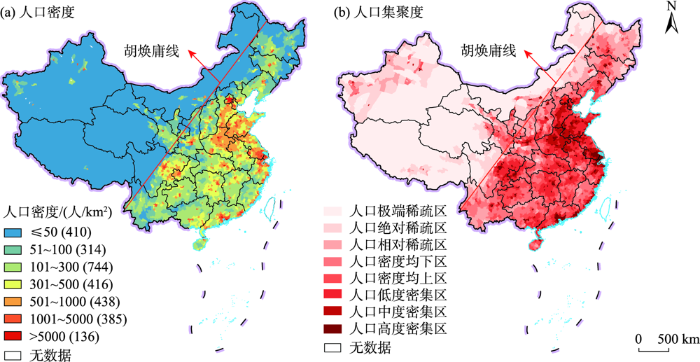
图1
2020年中国分县人口密度与人口集聚度
注:图a图例括号内的数字为对应人口密度区间的县域个数。本图基于自然资源部标准地图服务网站下载的审图号为GS(2019)1819号的标准地图制作,底图无修改。下同。
Fig.1
China's population density and agglomeration at the county-level in 2020
进一步从人口集聚度来看,中国以人口均值区和人口密集区为主,人口集聚度持续上升。2020年,人口均值区和人口密集区的县域单元数量分别为904个和1389个,约占总数的31.80%和48.86%,是中国主要的人口集聚类型。相应地,人口均值区和人口密集区的人口占比分别为71.30%和23.11%,土地面积占比分别为13.26%和22.21%。在进一步的集聚度分区中,人口高度密集区的县域单元数量为461个,土地面积占比仅为1.51%,而人口占比却达到了29.65%,人口密度平均值达到了2884人/km2。人口极端稀疏区的县域单元数量为144个,土地面积占比高达39.98%,人口却仅占0.62%,人口密度平均值仅为2人/km2。由此可见,中国的人口—土地分布极不均衡(表3)。从时间上来看,2020年中国分县人口集聚度为7.67,相较于2000年的6.44和2010年的7.06有了进一步提升,表明中国人口集聚的趋势在不断增强。另外,从空间上来看,2000—2020年,长三角、珠三角以及各省级单元省会的人口集聚度不断上升,同时人口密集区的县域个数却从2000年的1434个下降到了2020年的1389个,表明中国人口正向着少数的大城市快速集聚,人口空间分布愈加不平衡(图1b)。
表3 2020年中国分县人口集聚度分区统计
Tab.3
| 人口集聚度分区分类 | 县域行政单元数量/个 | 人口 | 土地 | 人口密度 | ||||||
|---|---|---|---|---|---|---|---|---|---|---|
| 总量/万人 | 比例/% | 面积/万km2 | 比例/% | 值域/(人/km2) | 均值/(人/km2) | |||||
| 人口密集地区 | 高度密集区 | 461 | 41784.12 | 29.65 | 14.49 | 1.51 | 1177~35571 | 2884 | ||
| 中度密集区 | 379 | 26155.97 | 18.56 | 33.66 | 3.51 | 588~1174 | 777 | |||
| 低度密集区 | 549 | 32548.76 | 23.10 | 78.91 | 8.24 | 294~588 | 412 | |||
| 小计 | 1389 | 100488.85 | 71.30 | 127.06 | 13.26 | 294~35571 | 791 | |||
| 人口均值地区 | 密度均上区 | 459 | 19967.36 | 14.17 | 95.57 | 9.97 | 147~294 | 209 | ||
| 密度均下区 | 445 | 12608.04 | 8.95 | 117.21 | 12.23 | 74~147 | 108 | |||
| 小计 | 904 | 32575.40 | 23.11 | 212.78 | 22.21 | 74~294 | 153 | |||
| 人口稀疏地区 | 相对稀疏区 | 251 | 4904.35 | 3.48 | 98.12 | 10.24 | 30~73 | 50 | ||
| 绝对稀疏区 | 155 | 2083.13 | 1.48 | 137.08 | 14.31 | 7~29 | 15 | |||
| 极端稀疏区 | 144 | 880.35 | 0.62 | 383.11 | 39.98 | 0.16~7 | 2 | |||
| 小计 | 550 | 7867.83 | 5.58 | 618.31 | 64.53 | 0.16~73 | 13 | |||
中国分县人口以减少为主,人口增长的县域主要为地级市及以上城市的市辖区和西部少数民族地区。相较于2000—2010年中国有1785个县域人口实现了正增长(占比62.79%),2010—2020年这一数字下降到了1315个(占比46.25%),减幅在1/3以上,当前中国大部分县域的人口已经向负增长转变。从空间分布上来看,相较于2000—2010年中国人口增加的县域广泛分布在东部沿海和西部少数民族地区,2010—2020年这一范围缩小到了长三角、珠三角、各省的地级市及以上城市的市辖区和新疆、青海、西藏等少数民族聚居区。而人口减少的县域则从2000—2010年的长江中下游省份和东北少数地区,在2010—2020年扩散到了中西部省份和东北绝大部分地区(图2)。
图2
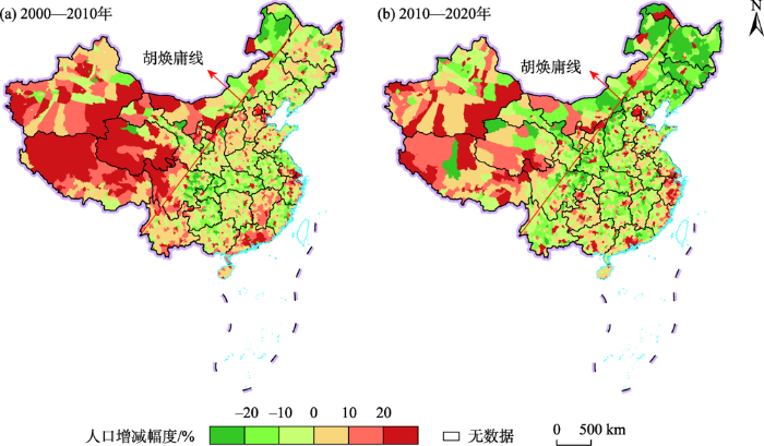
图2
2000—2020年中国分县人口变化率
Fig.2
China's population change rate at the county-level during 2000-2020
耦合2000年的人口集聚度和2000—2020年人口增减变化率,将中国2843个县域划分为9种人口发展类型(表4)。相较于2000—2010年人口密集区快速增长是占比最高的类型(19.63%),2010—2020年占比最高的类型变成了人口密集区负向增长(22.09%)。在空间分布上(图3),相较于2000—2010年,2010—2020年人口快速增长呈现3种类型: ① 人口密集区快速增长范围缩减到长三角、珠三角、各省省会以及区域中心城市,仅在重庆、成都、贵阳、合肥和郑州等中西部核心城市市辖区范围有所扩张;② 人口均值区快速增长范围由赣南、粤北和云贵川连片分布缩减为零散分布,仅在浙江沿海的台州和温州范围有所扩张;③ 人口稀疏区快速增长范围由胡焕庸线西北半壁的广大地区缩减为新疆、青海、西藏等少数民族聚居区。相应地,人口呈现负向增长的3种类型中:① 人口密集区负向增长范围扩张到黄淮海平原、长江中游、四川盆地和潮汕地区大部分地区;② 人口均值区负向增长范围扩张到东北平原、山西、赣南、粤北和云南大部分地区;③ 人口稀疏区负向增长范围扩张到内蒙古、甘肃西部、青海北部、四川西部等大部分地区。
表4 2000—2020年中国分县人口集聚度分区统计
Tab.4
| 人口集聚度分区 | 2000—2010年 | 2010—2020年 | |||
|---|---|---|---|---|---|
| 县域 数量/个 | 比例/% | 县域数量/个 | 比例/% | ||
| 人口密集区快速增长 | 558 | 19.63 | 514 | 18.08 | |
| 人口密集区慢速增长 | 404 | 14.21 | 271 | 9.53 | |
| 人口密集区负向增长 | 472 | 16.60 | 628 | 22.09 | |
| 人口均值区快速增长 | 175 | 6.16 | 122 | 4.29 | |
| 人口均值区慢速增长 | 328 | 11.54 | 202 | 7.11 | |
| 人口均值区负向增长 | 446 | 15.68 | 620 | 21.81 | |
| 人口稀疏区快速增长 | 183 | 6.44 | 102 | 3.59 | |
| 人口稀疏区慢速增长 | 137 | 4.82 | 105 | 3.69 | |
| 人口稀疏区负向增长 | 140 | 4.92 | 279 | 9.81 | |
图3
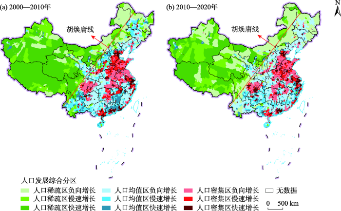
图3
2000—2020年中国分县人口发展综合分区
Fig.3
Typology of China's population development at the county-level during 2000-2020
2.2 城市群地区人口时空变化分析
城市群地区已经成为承载中国人口的主体区。2020年,19个城市群总人口达到了12.31亿人,占全国总人口的近9成,人口集聚度和人口密度均显著高于全国平均水平,表明城市群地区已经成为了中国人口集聚的主战场,在国家新型城镇化和经济高质量发展中发挥着战略核心区的作用(表5)。从时间上来看,2020年城市群地区各项统计指标进一步增长,相较于2000年,城市群地区总人口增加了1.53亿人,占全国总人口比重提升了0.74%,人口集聚度增加了1.52,人口密度也增加了33人/km2。总体来看,城市群地区人口集聚趋势进一步增强,人口承载的主体地位进一步提高。
表5 2000—2020年中国19个城市群人口整体情况统计
Tab.5
| 年份 | 人口总量/亿人 | 全国占比/% | 人口集聚度 | 人口密度/(人/km2) |
|---|---|---|---|---|
| 2000 | 10.78 | 86.65 | 7.73 | 229 |
| 2010 | 11.57 | 86.96 | 8.49 | 246 |
| 2020 | 12.31 | 87.39 | 9.25 | 262 |
大部分城市群人口持续增长,但哈长和辽中南城市群人口负增长。2020年,中国19个城市群中有5个人口超过了1亿人,其中长三角城市群人口最多,达到了1.81亿人,然后是长江中游(1.51亿人)、京津冀(1.28亿人)、成渝(1.14亿人)和山东半岛(1.1亿人)城市群,除山东半岛城市群外,均为优化提升的国家级城市群,而宁夏沿黄城市群人口最少,仅为457.85万人。从时间上来看,相较于2000—2010年,2010—2020年人口负增长的城市群由成渝和黔中城市群变成哈长和辽中南。人口增量前三的城市群由长三角、京津冀和珠三角变成了珠三角、长三角和京津冀,表明人口重心在向南移动(图4)。
图4
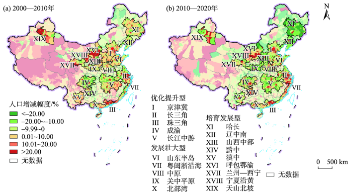
图4
2000—2020年中国19个城市群人口增减变化
Fig.4
Population change rate of urban agglomerations in China during 2000-2020
2.3 原连片特困地区人口时空变化分析
原连片特困地区人口持续减少。2020年,原14个连片特困地区总人口为1.98亿人,占全国总人口比重为14.08%,人口集聚度和人口密度均低于全国平均水平,从地理区位来看,该区主要位于自然本底较差的中西部,人口分布相对稀疏。2000—2020年,该区总人口减少超过1100万人,尤其是异地扶贫搬迁实施的2010—2020年,人口减少了860万人,人口集聚度和人口密度进一步下降(表6)。
表6 2000—2020年中国原连片特困地区人口增减统计
Tab.6
| 原连片特困地区名称 | 2000—2010年 | 2010—2020年 | |||
|---|---|---|---|---|---|
| 人口增减变化量/万人 | 人口增减变化率/% | 人口增减变化量/万人 | 人口增减变化率/% | ||
| 大兴安岭南麓山区 | 6.27 | 0.96 | -181.87 | -27.57 | |
| 燕山—太行山区 | 13.92 | 1.42 | -92.50 | -9.33 | |
| 大别山区 | -284.82 | -9.54 | -58.43 | -2.16 | |
| 罗霄山区 | 107.90 | 11.73 | -32.83 | -3.20 | |
| 吕梁山区 | -10.91 | -3.10 | -73.01 | -21.44 | |
| 六盘山区 | -41.60 | -2.18 | -140.71 | -7.52 | |
| 秦巴山区 | -171.60 | -5.47 | -250.49 | -8.45 | |
| 武陵山区 | -143.10 | -4.79 | -117.64 | -4.14 | |
| 乌蒙山区 | 85.76 | 4.66 | 6.53 | 0.34 | |
| 滇桂黔石漠化区 | -83.61 | -3.40 | 17.60 | 0.74 | |
| 滇西边境山区 | 71.61 | 4.96 | -103.98 | -6.87 | |
| 新疆南疆三地州 | 99.25 | 17.96 | 104.06 | 15.96 | |
| 四省藏区 | 66.38 | 13.99 | -2.67 | -0.49 | |
| 西藏区 | 38.93 | 14.85 | 63.73 | 21.17 | |
| 合计 | -245.62 | -1.17 | -862.22 | -4.16 | |
除少数民族聚居的地区外,原连片特困区以人口减少为主。从人口密度来看,原14个连片特困区大多人口密度较低,但仍有4个高于全国平均水平,分别是大别山区、罗霄山区、武陵山区和乌蒙山区,人均耕地面积少,人地关系较为紧张。从时间上来看,相较于2000—2010年,2010—2020年人口负增长的地区从6个上升为10个,占比由42.86%上升为71.43%,尤其是大兴安岭南麓山区和吕梁山区,10年间人口减幅在20%以上,呈大量流失的态势。人口正增长的地区主要为少数民族聚居区,尤其是新疆南疆三地州和西藏区,2010—2020年人口增幅分别在15%和20%以上,少数民族宽松的人口生育政策也使得当地人口增长较快(表6、图5)。
图5
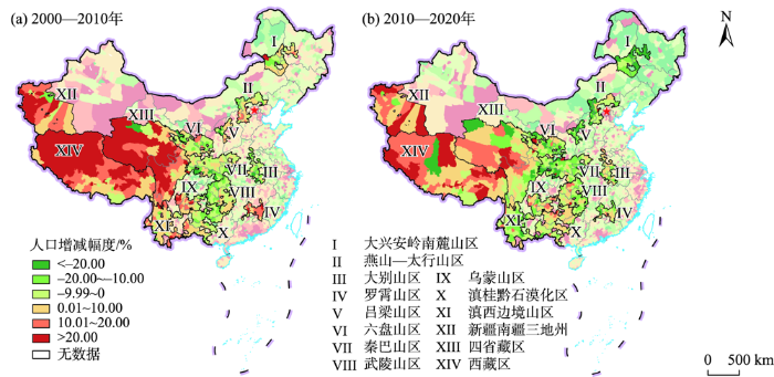
图5
2000—2020年中国14个原连片特困地区人口增减变化
Fig.5
Population change rate of the 14 original contiguous destitute areas in China during 2000-2020
2.4 边境地区人口时空变化分析
边境地区人口基本保持稳定。2020年,136个边境县的总人口为2184.2万人,占全国比重为1.55%,人口集聚度和人口密度均远低于全国平均水平,边境地区或因地形不适宜(如西南边境地形以高原和山地为主)或因气候不适宜(如北方边境寒冷干燥),是中国的人口稀疏地区。2000—2020年,边境地区总人口基本保持稳定,2020年人口集聚度和人口密度较2010年有所下降,占全国人口比重降低,是人口减少地区(表7)。边境地区是国防安全的第一线,未来应予更多的关注。
表7 2000—2020年中国边境地区人口增减统计
Tab.7
| 边境地区 划分 | 省份 | 2000—2010年 | 2010—2020年 | |||
|---|---|---|---|---|---|---|
| 人口增减变化量/万人 | 人口增减变化率/% | 人口增减变化量/万人 | 人口增减变化率/% | |||
| 东北边境 | 辽宁 | 8.35 | 7.02 | -12.28 | -9.64 | |
| 吉林 | -8.07 | -3.68 | -51.99 | -24.62 | ||
| 黑龙江 | 6.40 | 2.05 | -34.48 | -10.82 | ||
| 北部边境 | 内蒙古 | 6.59 | 3.62 | -29.39 | -15.56 | |
| 西北边境 | 甘肃 | 0.19 | 14.82 | 0.01 | 0.76 | |
| 新疆 | 45.96 | 10.41 | 40.36 | 8.28 | ||
| 西南边境 | 西藏 | 3.42 | 11.44 | 4.30 | 12.88 | |
| 云南 | 41.71 | 6.68 | 9.86 | 1.48 | ||
| 广西 | 5.66 | 2.73 | 10.44 | 4.91 | ||
| 合计 | 110.21 | 5.16 | -63.17 | -2.81 | ||
东北和北部边境人口下降较快,西北和西南边境人口持续增加。① 东北边境包含辽宁、吉林和黑龙江3省(区)的边境县,2000—2020年人口减少了92.07万人,其中2010—2020年减少了98.74万人,降幅达到了15.02%。分省来看,辽宁、吉林和黑龙江3省边境地区人口均为负增长,其中吉林和黑龙江2010—2020年人口减量分别超过了50万人和34万人,减幅在20%和10%以上。② 北部边境为内蒙古的边境县,2000—2020年人口减少了22.8万人,其中2010—2020年减少了29.39万人,降幅达到了15.14%。③ 西北边境县主要为新疆下辖,甘肃仅有肃北蒙古族自治县1个边境县。2000—2020年西北边境人口增长了86.52万人,其中2010—2020年增加40余万人,增幅在8%以上,属于人口较快增长地区。④ 西南边境包含西藏、云南和广西3省(区)的边境县,2000—2020年人口增长了75万余人,其中2010—2020年增加约25万人,增幅为2.7%,较2000—2010年有所下降,西藏、云南和广西3省(区)边境人口均为正增长,其中云南边境人口增幅不足1.5%,25个边境县仅9个正增长,广西边境人口增幅约为5%,8个边境县有5个正增长,而西藏边境人口增幅接近13%,18个边境县有15个正增长(表7、图6)。
图6
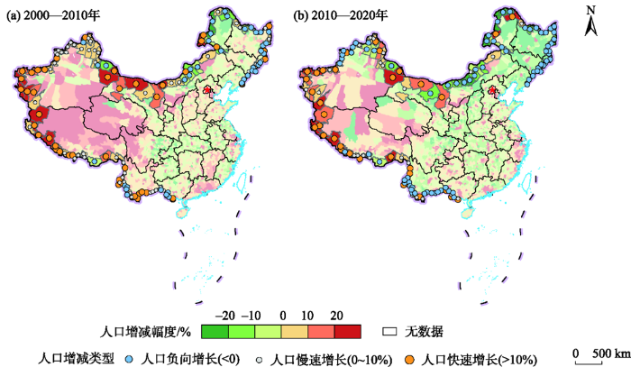
图6
2000—2020年中国边境县人口增减变化
Fig.6
Population change rate of China's border areas during 2000-2020
3 结论与讨论
3.1 结论
本文收集整理了从五普到七普的中国分县尺度人口空间分布数据集,采用人口密度、人口集聚度和人口增减变化等方法揭示了2000—2020年全国和不同类型地区(城市群地区、原连片特困地区和边境地区)的人口时空演变特征。主要结论为:
(1) 中国人口分布东密西疏的大势未变,但中国人口正向着负增长发展。2020年,中国以人口均值区和人口密集区为主,东南半壁和西北半壁人口仍稳定保持约94∶6的比值,中国人口东密西疏的态势并未发生根本改变。2000—2010年中国人口负增长的县域比例仅为37.21%,2010—2020年则增至53.75%,负增长已成为县域人口变化的主导类型。
(2) 城市群地区已经成为了中国人口集聚的主战场,大部分城市群人口持续增长。2020年,19个城市群总人口占全国总人口近90%,人口集聚度和人口密度均显著高于全国平均水平,城市群地区已经成为承载中国人口的主体区域。2010—2020年,除哈长和辽中南外,其他城市群人口均为正增长,尤其以珠三角和长三角城市群增长最为明显。
(3) 原连片特困地区人口持续减少,仅部分少数民族聚居区人口正增长。2020年,14个原连片特困地区人口占全国总人口比重为14.08%,并在2010—2020年减少了860余万人,人口集聚度和人口密度进一步下降。部分少数民族聚居地区人口增长明显,如新疆南疆三地州和西藏区,2010—2020年人口增幅超过15%。
(4) 边境地区人口基本保持稳定,但东北和北部边境地区人口下降较快。2020年,边境地区总人口不足2200万人,占全国比重不到1.6%,2010—2020年人口集聚度和人口密度略有下降,总人口保持稳定。2000—2020年,东北和北部边境地区人口分别减少了92万和22万人以上。边境地区人口下降带来的国防安全问题需要引起高度关注。
3.2 讨论
受限于数据可得性和篇幅限制,本研究仍有待深化。首先,深入探讨新形势下人口集疏变化背后的作用机制。未来应该系统地收集整理中国分县的社会经济指标,开展大范围的实地调研,采用定性和定量方法全面揭示中国人口集疏变化的作用机理。其次,关注不同类型人口的变化情况及其影响因素。如关注老年人口、高技能人口和流动人口等,以便更加有针对性地提出相应的政策建议,当然这都有待于更加详细的人口普查数据的公布。最后,开展人口普查数据格网化工作。人口数据多是基于行政区的统计数据,而自然科学研究中使用的数据大多是格网化的,为了更好地将人口数据应用于自然科学研究中,有必要将最新的人口普查数据格网化,以更好地支撑人地系统综合研究工作。
参考文献
认识人口基本演变规律, 促进我国人口长期均衡发展
[J].
Understand the basic laws of population evolution and promote the longterm balanced development of China's population
中国乡镇人口分布时空变化及其影响因素
[J].
DOI:10.11821/dlyj020210479
[本文引用: 3]

精细尺度的人口变化研究对于理解、模拟和调控人地系统具有重要参考价值,乡镇级的人口数据可以精细化揭示中国人口时空分布的演变特征。本文建立了2010年和2015年中国乡镇人口空间数据库,借助GIS空间分析方法和地理探测器模型揭示了乡镇人口时空变化特征及其影响因素。研究表明:2015年乡镇人口数量均值为2.95万、密度均值为374人/km<sup>2</sup>,乡镇人口数量和密度分布的区域差异较大;乡镇人口与土地面积分布相较县域呈现更加不均衡特征,人口密度大于150人/km<sup>2</sup>的19403个乡镇(60.81%),人口总量占比为81.76%、国土面积占比为20.27%,近似符合“二八定律”;2010—2015年,超过70.94%的乡镇人口数量有所增加(平均增幅19.33%),9273个乡镇人口减少(平均减幅13.33%),其中1684个乡镇(5.28%)的减幅超过20%,主要分布在东北、内蒙古和云南的边境地区;人口密度分布受地形起伏等自然地理条件,以及夜间灯光、路网密度所反映的社会经济因素等的综合影响,其作用机制存在明显的空间异质性。研究认为,乡镇人口的大幅增减变化及其显著差异格局对人地系统的优化调控,特别是编制国土空间规划、实施乡村振兴战略和保障国防安全等带来一定挑战,应给予足够重视。
Spatio-temporal evolution and driving factors of Chinese population at town level
DOI:10.11821/dlyj020210479
[本文引用: 3]
Research on high-resolution population evolution is of great reference for understanding, simulating, and managing the human-nature interrelationship. Town-level demographic data is the highest-resolution data publicly released by the National Bureau of Statistics of China. Therefore, it is of great significance to collect the population data of China at town level, and to carry out research on the spatiotemporal evolution and its influencing factors of Chinese population at town level. In this study, we established a spatial database of Chinese population at town level in 2010 and 2015, and then revealed its spatial and temporal pattern and influencing factors by Geographic Information System (GIS) analytical methods and Geodetector model. The results showed that: (1) In 2015, the average population of towns was 29,500, and the average population density was 374 persons/km2. Furthermore, there existed large spatial heterogeneity in China, the number of townships with a population of more than 10,000 is 781, mainly in the Yangtze River Delta and the Pearl River Delta, while the number of townships with a population of less than 5,000 is 2,498, mainly in the Qinghai-Tibet Plateau and Inner Mongolia. (2) The distribution of population and land area of townships was greatly uneven. There were 19,403 (60.81%) townships with a population density of more than 150 persons/km2, and their total population and land area accounted for 81.76% and 20.27%, respectively, which was approximately in line with “Pareto's Law”. (3) From 2010 to 2015, more than 70% towns’ population increased, by contrast, the population of more than 9,000 towns decreased, of which more than 1,600 towns experienced a population loss of more than 20%, and most of them were located in the border areas of Northeast China, Inner Mongolia and Yunnan. (4) The population distribution is comprehensively affected by physical geography (e.g., relief degree of land surface, negative effect) and socio-economic factors (e.g., night time light index and road density, positive effect), and its mechanism has obvious spatial stratified heterogeneity in different regions. This study argues that the rapid population growth or loss brings great challenges for harmonizing human-environment relationships, such as territory spatial planning, rural revitalization and national border security.
2000—2020年中国人口分布格局演变及影响因素
[J].
DOI:10.11821/dlxb202202008
[本文引用: 2]
基于第五、六、七次全国人口普查数据,本文分析了2000—2020年中国人口分布的空间格局、集散态势和影响因素。结果表明,中国人口分布依然保持东密西疏的基本格局,胡焕庸线两侧的自然地理环境差异性决定了这一格局的长期稳定性;人口空间集中化趋势在21世纪初的10年内主要发生在东南半壁,但在2010—2020年间成为各区域的共同特征。省会城市的人口集聚能力持续增强,2010—2020年的优势更加凸显,但这种行政力量主导的首位度提升效应将随着全省发展阶段的演进而逐渐弱化。人口变动的区域分化明显:沿海城市群的空间连绵化逐渐形成了强吸引力、高承载力的沿海人口增长带,东北地区几乎转向全面的人口收缩,中部各省依托省会展开的人口竞争依然激烈,川渝黔地区普遍实现了人口的止降回增,西北地区则面临人口收缩风险。此外,区域人口增长的驱动因素逐渐从经济要素主导转为经济要素和舒适性要素并重,各地区舒适性的差异可能将成为影响未来人口空间格局变化的重要因素。
China's changing population distribution and influencing factors: Insights from the 2020 census data
DOI:10.11821/dlxb202202008
[本文引用: 2]
Using data of the latest three decennial censuses, this paper systematically analyzes the overall spatial pattern, changing trends, and influence mechanisms of China's population distribution since 2000. The study reveals that the general population distribution pattern of "dense east and sparse west" in China has not changed, which is determined by the differences in natural geographic environments on the two sides of Hu Line. In the first decade of the century, population concentration was mainly found in the southeastern area, but it has been observed in all regions in the recent decade. Provincial capitals have become the winners of population competition and the advantages of population growth of provincial capitals have been further strengthened in the recent decade compared with 2000-2010. However, the administrative power-led effects of the increasing dominance of provincial capitals will gradually weaken with the development of their provinces. The regional differentiation of population changes is also apparent: coastal region gradually forms a dense belt of population and towns with solid population attraction based on the development of urban agglomerations; the northeast region almost turns to a complete population shrinking status; central provinces still compete fiercely for population based on their capitals; the population of Sichuan, Chongqing, and Guizhou has stopped the decline and returned to growth; and the northwest region faces the risk of population loss. In addition, this paper finds that the driving factors of regional population growth have gradually changed from economic factors to both economic and amenity factors, and the difference of amenities among regions may become an important factor for future changes in China's population geography.
从“七普”数据看中国人口发展、变化和现状
[J].
China's population development, changes and current situation, reference to data of the seventh population census
七普数据质量与中国人口新“变化”
[J].第七次全国人口普查漏报率达到历史最低水平,是一次高质量的普查。七普质量的提高既得益于中国政府巨大的社会组织和动员能力,也与此次普查采用电子化方式采集数据、增设普查对象互联网自主填报通道、加强多部门行政记录数据比对、增加身份证号码采集等新措施密切相关。七普数据体现了中国人口的新“变化”,有助于形成对中国人口客观事实的新认识,即当前中国人口呈现出“总量增多、两头上翘、中间塌陷”的状况。
Data quality of the 7th population census and new developments of China's population
The 7th Population Census has achieved the lowest underreporting rate in history and is therefore a highquality census. The improved quality of the data is not only due to the great social organization and mobilization capacity of the Chinese government, but also closely related to the new measures adopted in this census, including digital data collection, additional channels for respondents to register online, matching and verifying data by using administrative records across multiple sectors, and ID number collection. The 7th Population Census reflects new “changes” in the population, which may improve the knowledge of objective facts about the population. The current population of China is characterized by “a larger total population, a higher proportion of the young and of the elderly, and a lower proportion of the working-age population”.
The past, present, and future of population geography in China: Progress, challenges and opportunities
[J].DOI:10.1007/s11442-017-1413-5 URL [本文引用: 1]
中国人口之分布: 附统计表与密度图
[J].
DOI:10.11821/xb193502002
[本文引用: 1]
年来中外学者,研究中国人口问题者,日见其多,中国人口是否过剩,国境以内,是否尚有大量移民之可能,此实当今亟须解答之间题,各方对此之意见,甚为纷歧;或则谓中国人口,实已过剩,此可由社会生计艰难,失业问题严重,以及海外侨民之多可以证之;或则谓中国人口,实未过剩,以全国面积除全国人口,计算其密度,较之欧西诸国,尚不及远甚,国境西北部,地旷而人稀,将来实大有移民之可能.
Distribution of population in China: Attached with statistical table and density map.
DOI:10.11821/xb193502002
[本文引用: 1]
China is the most populous country of the world.Besides her great numberof population she has also the most densely inhabited regions which are notcomparable with any other country of the world.
关于“胡焕庸线能否突破”的学术争鸣
[J].
DOI:10.11821/dlyj201605001
[本文引用: 1]
著名地理学家胡焕庸先生于1935年提出中国人口地理的重要分界线(简称“胡焕庸线”),被广泛认可和引用,是中国地理学发展的重要成果。2014年底,李克强总理参观人居科学研究展时,高度关注胡焕庸线,并提出了胡焕庸线能否突破的问题。胡焕庸线因而再度引起争论和热议。据此,组织了一些地理学者围绕该问题进行学术讨论,力图从不同层面展现学者们对胡焕庸线的理解与反思,从而深化胡焕庸线的科学价值和现实意义,进而指导中国新型城镇化战略的实施和区域实践。
Academic debates on Hu Huanyong population line
DOI:10.11821/dlyj201605001
[本文引用: 1]
Hu Huanyong, a famous geographer, discovered a divide of population geography in China in 1935 (hereinafter referred to as the Hu Line), which was an important achievement in the development of the discipline of geography in China, and was widely accredited and cited. In November, 2014, Premier Li Keqiang raised a question about the Hu Line, when he visited the exhibition of sciences of human settlements in the National Museum of China. This question is whether the Hu Line can be broken or not again caused a stir. Hereby we invited some geographers to have academic discussion on this question, aiming to demonstrate their understanding and reflection on the Hu Line from different perspectives. Thus, the scientific value and practical significance of the Hu Line are deepened, and furthermore, the Hu Line can provide reference for the implementation and regional planning of the new-type urbanization in China.
2000年代以来中国省际人才的时空变动分析
[J].
An analysis to spatial-temporal changes of talents in all provinces of China since 2000s
中国县域城镇化发展格局及其影响因素: 基于2000和2010年全国人口普查分县数据
[J].
DOI:10.11821/dlxb201604007
[本文引用: 1]
利用2000 和2010 年中国人口普查分县数据,借助空间分析方法揭示近期中国常住人口城镇化格局特征及其动态变化,结合多元回归模型探讨城镇化空间分异的主要影响因素,基于主成分分析和聚类分析进行中国城镇化发展类型区划分。结果表明:① 2000-2010 年,中国常住人口城镇化率不断提高,年均增加1.3 个百分点,32%的县域城镇化水平年均增长超过1.5 个百分点;② 中国城镇化发展存在区域差异性和“低快高慢”的收敛性,东部、东北、中部、西部四大区域城镇化率年均分别增加1.4、0.5、1.4 和1.3 个百分点;③ 60%的中国县域城镇化发展集中在低城镇化率—高增长率、低城镇化率—中高增长率和低城镇化率—中增长率三种类型,且以中、西部地区分布最为密集;④ 中国县域城镇化格局基本未变,仍以珠三角、长三角、京津冀三大增长极的城镇化发展较为突出,东部地区及内陆省会城市周边的城镇化水平也相对较高;⑤ 经济发展水平、产业结构特征、人力资本状况、人口集聚能力、公共服务水平、地理区位特征对县域城镇化空间分异具有显著而稳健的影响;⑥ 中国城镇化格局可分为具有明显区类一致性和区外异质性的5 大类、20 个区域。新时期的城镇化发展应凸显地域功能、提升承载能力、夯实产业基础、强调节约集约。
Spatial pattern and influencing factors of urbanization development in China at county level: A quantitative analysis based on 2000 and 2010 census data
中国县域城镇化格局演化与优化路径
[J].
DOI:10.11821/dlxb202212001
[本文引用: 1]
县域城镇化的有序发展和优化布局,对于推进城乡要素平等交换、产业结构优化调整、资源与市场优化配置、促进城乡融合发展与乡村振兴具有重要战略意义。研究表明:① 2000—2020年中国县域城镇化快速发展且区域差异显著,东部沿海地区、中部城郊地区和北方边境地区的县域城镇化率相对较高,而西南地区、中部农区、西藏及新疆大部分地区的县域城镇化率偏低;2020年沿“胡焕庸线”东侧的东北地区、冀北及晋陕豫地区、川东及云贵地区成为县域城镇化率高值区,珠三角地区、长三角地区、京津冀地区、成渝地区、长江中下游地区、内蒙古边境地区,以及江浙闽东南沿海一带城镇化率超过50%的县域达716个,占比38.3%。② 县域城镇化是人口、经济、社会、文化等要素综合作用的结果,经济发展水平、自然环境条件、基础设施建设、地理区位条件、公共资源供给、专业创业集群与宏观政策等影响县域城镇化的方向、范围和深度。预测到2035年中国城镇化率为76.04%,县域城镇化率为64.38%。未来要重视强化县域人口、经济、社会和空间组织结构的调整优化。③ 县域城镇化发展可分为大城市周边县域要素集聚型城镇化、专业功能县域产业集聚带动型城镇化、农产品主产区县域农业现代化引领型城镇化、重点生态功能区县域生态保育型城镇化、人口流失县域异地转移集中型城镇化等5种类型。④ 县域城镇化以县城和重点镇作为要素集聚的重要空间载体,形成居业协同与产城融合的多级体系。通过构建产业全价值链、主导产业关联集群、公共服务融合配置体系等创新路径,将推动城乡要素平等交换与公共资源均衡配置、城乡产业融合与等值化发展,促进城乡融合网络化、城乡治理体系化与资源利用集约化,为优化县域人地关系和城镇化空间体系提供持久动力。
Pattern evolution and optimal paths of county urbanization in China
DOI:10.11821/dlxb202212001
[本文引用: 1]
The orderly development of county urbanization, as an effective driving force for the integrated development of urban and rural areas in the new era, promotes the interaction and flow of elements between urban and rural territorial system, the optimization and adjustment of industrial structures, the optimal allocation of resources and markets, and the organic integration of urban and rural territorial system. The results show that: (1) From 2000 to 2020, the county urbanization in China developed rapidly, and the regional differences in spatial and temporal dynamics were significant. The county urbanization rate in the eastern coastal, central suburbs and northern border areas was high, while it is low in southwest China, rural areas of the central region and most parts of Tibet and Xinjiang. In 2020, to the east of the Hu Huanyong Line, the northeastern region, northern Hebei, Shanxi-Shaanxi-Henan region, eastern Sichuan, and Yunnan-Guizhou region became high-value areas for urbanization rates at the county level. There are 716 counties with urbanization rates exceeding 50%, including the Pearl River Delta, the Yangtze River Delta, the Beijing-Tianjin-Hebei region, the Chengdu-Chongqing region, the middle and lower reaches of the Yangtze River, the border areas of Inner Mongolia, and the southeastern coastal areas of Jiangsu, Zhejiang and Fujian, accounting for 38.3% of the country's total. (2) The county urbanization in China is the result of the combined effects of factors such as population, economy, society, and culture. The level of economic development, natural environment conditions, infrastructure construction, geographic locations, public resource supply, professional entrepreneurial clusters, and macro policies affect the direction, scope and depth of county urbanization. It is predicted that by 2035, the urbanization rate of China will reach about 76.04%, and that of counties will be about 64.38%. In the future, we should strengthen the adjustment and optimization of county population, economy, society and spatial organizational structure. (3) There are five types of county urbanization in China, including factor agglomeration urbanization in counties around big cities, industrial agglomeration-driven urbanization in counties with specialized function, agricultural modernization-led urbanization in counties with main agricultural production areas, ecological conservation urbanization in counties with ecological function areas, and concentrated urbanization in counties with population loss. (4) County urbanization takes county and key towns as important spatial carriers for the agglomeration of urbanization elements, and forms a multi-level system of residence-industry and industry-city coordination. The rational spatial distribution of factors such as the development of industrial integration and population resources will further promote the interactive flow of urban and rural elements, the integration of urban and rural industries, the equalization of urban and rural residents, and the equalization of urban and rural infrastructure, and enhance urban-rural integration and network development.
The impacts of transport accessibility on population change across rural, suburban and urban areas: A case study of Wisconsin at sub-county levels
[J].
DOI:10.1177/0042098011431284
URL
[本文引用: 1]
A large body of research has found that highways and airports have played important roles in promoting development and population growth (or decline). However, little attention has been paid to the possible spatial variation of their effects on population change. This study uses data related to population change in 1980–90 at the minor civil division level in Wisconsin to investigate the effects of highway and airport accessibility and accessibility improvements on population change across rural, suburban and urban areas. The results show that the effects vary across the three area types. In rural areas, highway improvement and airport accessibility promote population growth; in suburban areas, airport accessibility promotes population growth but highway accessibility facilitates population flows; and in urban areas, neither highways nor airports have a statistically significant effect on population change. The findings have important implications for local transport planning, as highways and airports play different roles along the rural–urban continuum.
Urban and rural population growth in a spatial panel of municipalities
[J].DOI:10.1080/00343404.2016.1144922 URL [本文引用: 1]
Impact of international travel and border control measures on the global spread of the novel 2019 coronavirus outbreak
[J].
DOI:10.1073/pnas.2002616117
PMID:32170017
[本文引用: 1]
The novel coronavirus outbreak (COVID-19) in mainland China has rapidly spread across the globe. Within 2 mo since the outbreak was first reported on December 31, 2019, a total of 566 Severe Acute Respiratory Syndrome (SARS CoV-2) cases have been confirmed in 26 other countries. Travel restrictions and border control measures have been enforced in China and other countries to limit the spread of the outbreak. We estimate the impact of these control measures and investigate the role of the airport travel network on the global spread of the COVID-19 outbreak. Our results show that the daily risk of exporting at least a single SARS CoV-2 case from mainland China via international travel exceeded 95% on January 13, 2020. We found that 779 cases (95% CI: 632 to 967) would have been exported by February 15, 2020 without any border or travel restrictions and that the travel lockdowns enforced by the Chinese government averted 70.5% (95% CI: 68.8 to 72.0%) of these cases. In addition, during the first three and a half weeks of implementation, the travel restrictions decreased the daily rate of exportation by 81.3% (95% CI: 80.5 to 82.1%), on average. At this early stage of the epidemic, reduction in the rate of exportation could delay the importation of cases into cities unaffected by the COVID-19 outbreak, buying time to coordinate an appropriate public health response.Copyright © 2020 the Author(s). Published by PNAS.
A meta-analysis of country-level studies on environmental change and migration
[J].DOI:10.1038/s41558-020-0898-6 [本文引用: 1]
The evolution of demographic methods
[J].
长江三角洲人口分布演变、偏移增长及影响因素
[J].
DOI:10.18306/dlkxjz.2020.12.009
[本文引用: 1]
在长江三角洲区域一体化上升为国家战略背景下,论文运用核密度、重心、集中指数和偏移—分享等方法,研究2000—2018年长江三角洲人口时空演变规律,并采用定量方法探讨人口偏移增长影响因素。结果表明:① 部分城市主导下的人口集散趋势转变,并未显著改变区域人口不均衡格局,且集中度呈现稳步增长态势。② 基于偏移—分享法的研究发现,人口增长格局转变主要表现为部分欠发达地区人口增速加快,如三省一市上安徽省转变为正偏移增长、城市尺度上核心发达城市为主的正偏移增长向部分欠发达城市为主的正偏移增长转变、县域尺度上正偏移市辖区由核心区向边缘区的转移,但人口向少数大城市、市辖区集聚的态势显著,而多样化的人口偏移增长态势表征了未来城市发展策略的差异化需求。③ 经济因素、社会发展和财政水平等是长江三角洲人口偏移增长的重要驱动力,而影响因素的时空演变表明,未来人口均衡化政策的制定不仅要因地制宜,更要与时俱进。
Change in distribution and growth shifts of population in the Yangtze River Delta and influencing factors
DOI:10.18306/dlkxjz.2020.12.009
[本文引用: 1]
Population distribution is an important indicator of regional development patterns. Also, regional coordinated development is closely related to the balanced distribution of the population. In the context of the regional integration of the Yangtze River Delta as a national strategy, the population distribution across the Yangtze River Delta has undergone significant changes. Using Kernal density analysis, gravity center analysis, concentration index, and shift-share analysis methods, this study examined the spatio-temporal change characteristics of the population in the Yangtze River Delta from 2000 to 2018, and explored the influencing factors as well as internal mechanisms of population growth shifts by utilizing quantitative methods. The main conclusions are as follows: 1) The shift in the population distribution trend led by some cities did not significantly change the imbalanced pattern of regional population distribution, and the increase in the concentration index indicates that the regional population concentration showed a steady growth trend. 2) The research based on shift-share analysis found that the shift in population growth pattern was mainly manifested in the acceleration of population growth in some underdeveloped areas. For example, Anhui Province was transformed into positive growth shift at the provincial scale. On the city scale, the positive growth shift dominated by core developed cities has changed to the positive growth shift dominated by some less developed cities. The spatial distribution of positive growth shift of municipal districts changed from the core areas to the peripheral areas. However, the population was still attracted to a few large cities and municipal districts. The diversified population growth shift trend characterizes the differentiated demands for future development strategies. 3) Economic factors, social development, and financial resources were important driving forces of population growth shift in the Yangtze River Delta. However, the temporal and spatial change of influencing factors shows that the formulation of future population balancing policies not only needs to be adapted to local conditions, but also should evolve through time. This research not only provides a reference for the formulation of relevant population policies, but also enriches the empirical findings on the spatial and temporal change of population.
基于人口集聚度的中国人口集疏格局
[J].
DOI:10.11820/dlkxjz.2010.10.003
[本文引用: 3]
人口集聚和疏散是人口空间分布格局最直观和最集中的体现,研究一个地区人口集疏的空间格局,不仅可以揭示该地区人口集疏的内在规律,也有利于深入研究该地区的整体人口分布的态势和规律,更能够体现出区域内经济格局以及城市化格局的发展。基于人口集聚度的中国人口集疏空间格局的研究,有助于准确把握中国人口空间分布的基本脉络,具有一定的学术价值和实践意义。本研究采用了人口集聚度分级评价的方法,依据人口集聚度的不同,将各个地区划分为不同等级的人口集聚区,并对其分别讨论。在此基础上,结合中国人口分布格局、自然条件空间格局、人居环境自然适宜性评价结果以及经济发展格局和城市化格局,对中国的人口集疏的空间格局进行了归纳,得出了中国人口分布“西疏东密”的传统空间格局突出,人口集聚以平原地区为依托并呈现“沿海、沿江、沿线”高度集聚的特征的结论。
Research on the spatial pattern of population agglomeration and dispersion in China
DOI:10.11820/dlkxjz.2010.10.003
[本文引用: 3]
<p>Population agglomeration and dispersion are the most direct and the most concentrated expression of population spatial distribution pattern. The research on population agglomeration and dispersion spatial pattern and its formation mechanisms in a specific region will not only help to reveal the population agglomeration and dispersion in the region of the inherent law itself, but also benefit the study of the overall regional population spatial pattern, and even further, the study of regional economy agglomeration and urbanization. With the largest population and significant difference in regional natural condition and economy, China’s population agglomeration and dispersion, in terms of not only the size but also complexity, are not comparable in the world. Thereby, research on the spatial pattern of China’s population agglomeration and dispersion, which will contribute to grasping the essence of China’s population spatial distribution pattern, is of great significance in both academy and practice. The article chose the classification evaluation of population agglomeration, which classified China into many population agglomeration types of different levels according to their population centralization index, and then, discussed them in each type. Based on this and the comprehensive consideration on the spatial distribution pattern of China’s population, natural conditions, human environment suitability and economic development, the article generalized the spatial pattern of China’s population agglomeration and dispersion.</p>
Spatiotemporal and socioeconomic risk factors for dengue at the province level in Vietnam, 2013-2015: Clustering analysis and regression model
[J].Dengue is a serious infectious disease threat in Vietnam, but its spatiotemporal and socioeconomic risk factors are not currently well understood at the province level across the country and on a multiannual scale. We explore spatial trends, clusters and outliers in dengue case counts at the province level from 2011–2015 and use this to extract spatiotemporal variables for regression analysis of the association between dengue case counts and selected spatiotemporal and socioeconomic variables from 2013–2015. Dengue in Vietnam follows anticipated spatial trends, with a potential two-year cycle of high-high clusters in some southern provinces. Small but significant associations are observed between dengue case counts and mobility, population density, a province’s dengue rates the previous year, and average dengue rates two years previous in first and second order contiguous neighbours. Significant associations were not found between dengue case counts and housing pressure, access to electricity, clinician density, province-adjusted poverty rate, percentage of children below one vaccinated, or percentage of population in urban settings. These findings challenge assumptions about socioeconomic and spatiotemporal risk factors for dengue, and support national prevention targeting in Vietnam at the province level. They may also be of wider relevance for the study of other arboviruses, including Japanese encephalitis, Zika, and Chikungunya.
Aging in place in gentrifying neighborhoods: Implications for physical and mental health
[J].DOI:10.1093/geront/gnx105 URL [本文引用: 1]
The utilization of maternal healthcare services among ethnic minority populations in Vietnam
[J].DOI:10.1007/s40615-020-00832-5 [本文引用: 1]
Exploring the consequences of climate-related displacement for just resilience in Vietnam
[J].
DOI:10.1177/0042098019830239
URL
[本文引用: 1]
Connections to place and relations between people are being radically reconfigured in response to climate risks. Climate change is likely to increase the scale of displacement in the Asia Pacific region, leading to intensified patterns of migration as well as resettlement. These two processes, though differing in terms of individual agency and the role of the state, are likely to further exacerbate pressure on urban areas. As the limits to adaptation in risky places are reached, people are increasingly pursuing migration as a way of coping. This strategy demonstrates people’s agency to respond to risks and opportunities. Resettlement, in contrast, tends to undermine people’s agency. This risk response is increasingly being implemented by states as part of climate change adaptation plans, yet, it often results in the creation of new vulnerabilities for those forcibly resettled. Through a focus on the ‘climate hotspot’ of the Mekong Delta, Vietnam, this paper explores how communities and governments might anticipate and resolve some of the humanitarian, livelihood and ecological challenges associated with resettlement in an increasingly resource-constrained and risky climate future. The concept of just resilience is proposed as a lens through which the consequences of resettlement for people’s connections to place, each other and familiar ways of life can be understood. It is argued that a focus on just resilience reveals opportunities and threats to procedural, distributive and recognition elements of justice associated with adapting to climate change.
中国城镇人口“镇化”发展的时空分异
[J].
DOI:10.11821/dlyj020180497
[本文引用: 1]
将中国人口城镇化细分为城镇人口“镇化”与“城化”,采用“镇化水平”和“镇化贡献率”两个指标,从不同空间尺度及主体功能区视角,系统分析1982-2015年中国城镇人口镇化发展的时空分异及影响因素。主要结论包括:① 中国的城镇人口“镇化水平”和“镇化贡献率”在不断提升。2015年镇化水平为41.8%,2010-2015年期间镇化贡献率为55.1%。② 中国城镇人口镇化呈现显著的时空分异特征。镇化主导型县市主要分布在中西部地区,占全国国土面积的70%以上;城化主导型县市主要集中分布在沿海城市群地区,在全国国土面积中所占比例较小。③ 展望未来,中国城镇人口的镇化贡献率和镇化水平将稳中趋缓,应加强探索出基于主体功能区域分异的差异化小城镇发展模式。
Spatial-temporal difference of "townization" of urban population in China
DOI:10.11821/dlyj020180497
[本文引用: 1]
In this paper, the urbanization of China's population was subdivided into "townization" and "cityization", and the indicators of "townization level" and "townization contribution rate" were adopted. From the perspective of different spatial scales and major function oriented zones, this paper conducted the system analysis on space-time disparity and influencing factors of the development of urban population in China from 1982 to 2015. The main conclusions included: (1) China's urban population's "townization level" and "townization contribution rate" continued to increase. In 2015, townization level was 41.8%, and the townization contribution rate was 55.1% during the period from 2010 to 2015. (2) The urbanization of China's urban population presented significant spatial and temporal differences. The townization-dominated counties and cities were mainly distributed in the central and western regions of China, accounting for more than 70% of the country's total land area. The cityization-dominated counties and cities were mainly concentrated in coastal urban agglomerations, and had a relatively small proportion in the national land area. (3) Looking into the future, China's urban population's "townization level" and "townization contribution rate" would increase steadily but slower and slower. It was necessary to strengthen the exploration of a differentiated development model of small towns based on the differentiation of major function oriented zones.
区域协调发展背景下流动人口回流的空间意愿及其政策含义
[J].
DOI:10.11821/dlyj020201102
[本文引用: 1]
人口空间分布格局的改变既是区域协调发展战略实施的结果,也是推进区域协调发展的重要手段之一。本文以流动人口的回流空间意愿作为切入点,采用全国性大规模抽样问卷调查数据,对流动人口回流的空间意愿、群体差异和影响因素进行研究,并探讨其对区域协调发展和新型城镇化的政策含义。研究发现,流动人口的回流意愿薄弱;对具有回流意愿的流动人口来说,回流空间的路径选择以返回原居地为主、乡镇中心和县城为辅。模型结果显示,流动人口回流空间选择不仅是其人力资本和流动经历正向选择的结果,也显著地受到流出地住房和流入地的就业收入和养老保险等因素的影响,而流出地的家庭需求和空间成本则无显著影响。在此背景下,政策制定者不能高估人口回流对人口流动空间格局和人口均衡发展的调整作用,也不能高估回流劳动力对流出地城镇化和城乡协调发展的促进作用,而应加强流出地城镇自我可持续发展的能力,吸引人口主动回流,以推进区域协调发展和新型城镇化战略的落实。
Locational intention of return migration of migrants and its policy implications in the context of coordinated regional development
DOI:10.11821/dlyj020201102
[本文引用: 1]
With rapid development of urbanization and continuous decline of the birth rate, migration has become an important factor affecting population distribution and coordinated regional development in China. Return migration, which is promoted by global economic restructuring, industrial upgrading in the coastal areas, and the relocation of industries from coastal to inland areas, has emerged as a new trend of migration with potentially important spatial and developmental implications. Some important research questions, such as what the locational preferences of migrants are when they return, whether return migrants can serve as catalysts to promote in-situ urbanization in the central and western regions and coordinated regional development in China, have arisen from this new trend and need to be urgently addressed. However, so far not enough attention has been paid to this important trend of migration and its spatial and developmental effects. Using data from China Migrant Dynamic Survey in 2016, this paper addresses the above research questions by examining migrants’ locational intention of return migration, its determinants, and its policy implications for population distribution and coordinated regional development. The results show that migrants’ return intention is low, and for those with return intention, the original places of residence (villages) are the main locations they choose to return, followed by the seats of town, township and county governments. The modelling results reveal that migrants’ locational intention of return migration is not only positively related to their human capital, but also significantly affected by the factors of housing in the original places, and employment, income and endowment insurance in the destination cities. At the same time, we find that factors relating to migrants’ mobility characteristics significantly affect migrants’ locational choice of return migration, while family demand in the original places has no significant effect. These results suggest that policy makers should not overestimate the role of return migration in reshaping the spatial patterns of migration and coordinated regional development, especially the urbanization of migrants’ places of origin. Instead, efforts should be made to strengthen the capability of self-sustainable development of urban areas in the places of origin, so as to attract more active returning migrants, and promote the implementation of the coordinated regional development strategy.
新时代老龄化与养老资源适配度时空差异及其影响因素分析
[J].
DOI:10.13249/j.cnki.sgs.2022.05.011
[本文引用: 1]
运用核密度估计、耦合协调模型、空间杜宾模型等方法对中国老龄化、养老资源配置、养老资源配置与老龄化适配度的演化格局进行了探讨,并揭示空间适配的影响因素,研究发现:① 中国老龄化程度不断上升,且呈现“东高西低”空间特征;② 中国养老资源配置整体水平提高,空间分布上离散程度上升,各省(区、市)之间的绝对差异随着时间的推移呈扩大态势;③ 各省(区、市)养老资源与老龄化的空间适配度明显改善,适配度呈现东部沿海向中西部递减的发展格局,空间集聚程度不断提高;④ 养老投资、政策关注度、养老相关志愿者、老年人抚养比均推动本地养老资源与人口老龄化的空间适配,养老相关志愿者、老年人抚养比还具有明显的正向溢出效应,而老年人协会则抑制周边地区养老资源空间适配。
Spatial and temporal differences and influencing factors of the adaptation degree of aging and pension resources in the new era.
DOI:10.13249/j.cnki.sgs.2022.05.011
[本文引用: 1]
Whether the supply of pension resources matches the degree of aging is related to the allocation efficiency of pension resource and the welfare level of the elderly enjoying the related services equally. In the new era, the elderly in China have undergone profound changes in lifestyle, quality of life and life philosophy. Based on the needs of aging in the new era, rational allocation of old-age resources is of great significance for implementing the national strategy of actively responding to aging and promoting the high-quality development of the cause of aging. Using kernel density estimation, coupled coordination model and spatial Durbin model, this study discusses the evolution pattern of aging, the allocation of pension resources and the adaptation degree between the allocation of pension resources and aging in China. The study also reveals the influencing factors of the spatial adaptation between the allocation of pension resources and China’s aging. The results show that: 1) The degree of aging in China is increasing, and it presents the spatial characteristics of “high in the east and low in the west”. 2) In China, the overall level of pension resources allocation has been improved, and the degree of spatial dispersion has increased. The absolute difference between provinces (autonomous regions and municipalities) has expanded with the passage of time. 3) The spatial adaptation between pension resources and aging has improved significantly, but the spatial heterogeneity is prominent, showing a declining development pattern from the eastern coast to the central and western regions as a whole; the agglomeration degree of spatial adaptation changes from strong to weak and then to strong. On the whole, the spatial agglomeration degree is constantly improving, but with the migration of time, it has a polarization trend. 4) The spatial adaptation between pension resources and aging has a significant positive spatial spillover effect. Among the influencing factors, pension investment and policy attention can promote the spatial adaptation of pension resources and population aging in this region; the elderly association reduces the spatial adaptability of the allocation of pension resources in neighboring provinces through spillover effect; the dependency ratio of old-age volunteers and the elderly can not only effectively promote the spatial adaptation of pension resources and aging in this province, but also improve the spatial adaptation of pension resources in neighboring provinces; the role of old-age institutions in spatial adaptation of pension resources is not obvious.
Analyzing the distribution of researchers in China: An approach using multiscale geographically weighted regression
[J].DOI:10.1111/grow.v52.1 URL [本文引用: 1]
2005—2015年中国高校科研人才的时空变化及影响因素分析
[J].
DOI:10.13249/j.cnki.sgs.2019.08.001
[本文引用: 1]
基于2005~2015年全国统计年鉴数据,采用统计地图法和空间自相关分析,分析中国高校科研人才的时空分布特征(不包括港澳台数据),并采用面板负二项回归模型,识别高校科研人才空间分布的决定因素。研究结果表明:①中国的高校科研人才分布表现出较强的空间不均衡性,总体趋势为东南密集,西北稀疏,科研人才高度集中在北京、天津、上海;②高校科研人才分布具有一定的空间集聚特征,其热点地区为北京、天津、上海和江苏等沿海省市,冷点地区集中分布在广大的西部地区和黑龙江省。2005~2015年,高级职称人才的空间集聚程度有所减弱,而中初级职称科研人才的空间集聚程度有所加强;③人才政策、高等教育规模和层次、公共服务水平和信息化水平是所有高校科研人才空间分布的主要影响因素。从职称差异的角度来看,薪酬和失业率等经济因素仅对初级职称科研人才的分布有影响,医疗、文化公共服务水平和人才政策仅对中高级职称科研人才的分布有影响,高等教育的规模与层次对各种职称人才的分布均有影响;从地区差异的角度来看,西部地区高校科研人才受到经济因素影响更为明显,而中东部高校科研人才受到公共服务水平影响的更为明显。
Spatio-temporal change of facaulty members of higher education institute and its influential factors in China in 2005-2015
DOI:10.13249/j.cnki.sgs.2019.08.001
[本文引用: 1]
Based on the national statistical yearbook data from 2005 to 2015, this article studies the spatial pattern evolvement of the distribution of scientific research talents in China (limited to data, the study area not includes Hong Kong, Macao and Taiwan) and its influence mechanism by applying panel negative binomial regression and spatial auto-correlation analysis. The result shows that: 1)The distribution of scientific research talents in China showed great imbalance. Generally speaking, talents agglomerate in the southeast but sparse in the northwest. Scientific research talents are mainly agglomerate in Beijing, Tianjin and Shanghai; 2) The distribution of scientific research talents has some spatial agglomeration characteristics. Hot spots are the eastern coastal areas, especially Beijing, Tianjin, Shanghai and Jiangsu while the cold point area is concentrated in the western region and Heilongjiang Province. The area of cold points has decreased from 2005 to 2015; 3) Talent policy, the development of universities and the level of public service are the main factors that determines the overall spatial distribution of scientific research talents, but no evidence support that other factors have significant influence. With the increase of professional qualification, the influence of the economic factors on the scientific research talent gets weaker, but the influence of public service level gets stronger. On the other hand, from the perspective of regional differences, compared with the western regions, the scientific research talents working in middle and eastern universities are more likely to be affected by the public service.
新发展格局下的中国城市群与都市圈建设
[J].
China's urban agglomeration and metropolitan area construction under the new development pattern
DOI:10.2307/141854 URL [本文引用: 1]
城市群视角下中国人口空间分布研究
[J].
A study on population spatial distribution in China from the perspective of urban agglomeration
人文地理学视域下中国边境地区研究进展与展望
[J].
DOI:10.18306/dlkxjz.2022.10.013
[本文引用: 1]
边境地区是重要的国家安全屏障和多重权力空间影响下的特殊脆弱地带。科学总结边境研究发展历程有助于厘清边境研究脉络,为实现边境长治久安与可持续发展提供科学支撑。论文以中国知网(CNKI)和科学引文索引(Web of Science)中人文地理学相关视域下的中国边境研究学术论文为依据,借助科学知识图谱方法,分析了1990年以来中国边境研究历程、趋势及热点等基本特征。研究发现:中国边境研究经历了“开放探索—社会建构—战略引领”的发展历程,研究热点区域逐渐由东北地区转向西南地区,“边境贸易”“边境旅游”“边境口岸”“一带一路”是4个核心关键词聚类。边境研究主要内容包括边境贸易与开发开放、边境旅游资源开发、社会建构与和谐发展、边境口岸与城市功能,以及地缘环境与边境安全。当前,中国边境研究在规律探索、定量总结等方面仍然不足,论文在构建多要素—多主体—多尺度集成的边境地理研究框架基础上,提出未来应加强边境风险与安全、跨境合作机制、边境效应理论、边境可持续发展等研究,为后续边境研究提供参考,支撑中国边境安全与现代化治理。
Progress and prospect of research on China's border areas from the perspective of human geography
Revitalize the world's countryside
[J].DOI:10.1038/548275a URL [本文引用: 1]
原连片特困地区共同富裕能力评价及其演变跃迁
[J].
Original contiguous destitute areas' common prosperity capability evaluation and evolution transition
“胡焕庸线”的稳定性及其两侧人口集疏模式差异
[J].
DOI:10.11821/dlxb201504004
[本文引用: 1]
“胡焕庸线”是反映中国人地关系的重要地理发现之一。在当今中国经济社会背景下,“胡焕庸线”所表达地理意义及其对城镇化发展的指导作用受到广泛关注。在GIS的支持下,构建了改革开放以来4次人口普查的县级空间数据库,提出人口时空扩张的识别方法,对“胡焕庸线”两侧的人口数量、集疏格局进行统计、分析,主要得出以下结论:① “胡焕庸线”两侧人口数量94:6的大数一直相对稳定,但东南半壁人口持续微减、西北半壁人口持续微增。得益于较高的自然增长率,西北半壁具有较高的人口增长速度。② “胡焕庸线”两侧呈现出迥然不同的人口集疏模式。东南半壁人口集中化程度提升较快,负增长区在“秦岭—淮河”以南、东北等地区大面积扩张、人口正增长优势逐步极化到长三角、珠三角、京津等少数地区,呈现“马太效应”式的集疏模式。主要是由于东南半壁内部区域经济差异及快速城镇化带来的剧烈人口流动。③ 西北半壁则呈现“相对均势”的人口集疏模式,多数地区的人口普遍表现为正增长,但是空间分布广袤、增长不集中,人口集中化程度提升缓慢。主要是由于少数民族“多分散、少聚居”造成了自然增长优势的不集中。然而均势是相对而不是绝对的,同样存在一定的负增长区,主要分布在“胡焕庸线”和“新欧亚大陆桥”两条带上。④ 未来时期,“胡焕庸线”两侧的人口分布及集疏格局将进一步演化,东南半壁应关注内陆腹地及中小城镇对人口的吸纳作用,西北半壁应关注将分散的人口增长优势向少数城镇进行集聚,以期为人口地理学研究以及城镇化发展提供参考。
Study on the stability of Hu Line and different spatial patterns of population growth on its both sides
DOI:10.11821/dlxb201504004
[本文引用: 1]
The Hu Line for population distribution in China has been regarded as one of the greatest geographical discoveries in China because it reveals the significant spatial characteristics of China's human-land relationship. Thus, the stability and significance for spatial development of Hu Line have become a major concern after the dramatic economic and social changes since China's reform and opening-up in 1978. With the support of GIS, this paper conducts a statistical analysis and systematic investigation on the stability and spatial patterns of population growth on both sides of Hu Line by constructing the spatial database of China's census data from 1982 to 2010 and initiating a new method for identifying the spatial patterns of population growth. The findings are as follows: (1) The Hu Line has been rather stable, while a new tendency of population change has emerged. On the whole, the ratio of population on both sides of Hu Line has roughly been kept at 94:6 (the southeastern side: the northwestern side) in the last 30 years. However, the proportion of population on the southeastern side of Hu Line has been slightly decreasing, while that on the northwestern side of Hu Line has been slightly increasing, which is benefited from its higher rate of natural population growth. (2) The spatial patterns of population growth on both sides of Hu Line were quite different. The agglomeration degree of population distribution on the southeastern side of Hu Line increased greater. The areas with negative population growth rate have rapidly expanded, mainly located south of the Qinling Mountains - Huaihe River line and the northeastern China, while the areas with the fast population growth rate concentrated in the areas such as the Yangtze River Delta, the Pearl River Delta and Beijing-Tianjin metropolitan region. Thus, the spatial pattern of population growth on the southeastern side of Hu Line presented an aggregating and diffusion mode of Matthew effect. (3) The spatial pattern of population growth on the northwestern side of Hu Line could be referred as the relative balance type. In this region, the positive rate of population growth and the lower agglomeration degree of population have been identified. There were lots of ethnic groups located on the northwestern side of Hu Line, and they generally lived dispersedly but with a higher rate of natural population growth due to preferential population policy. However, there were also some areas with negative rate of population growth on the northwestern side of Hu Line and they were mainly distributed close to the Hu Line and new Eurasia Land Bridge. (4) In the future, the spatial patterns of population growth on both sides of Hu Line will continue to change. On the southeastern side of Hu Line, the capacity of population agglomeration for those small and medium-sized cities and towns should be enhanced. As for the northwestern side of Hu Line, the emphasis should be placed on promoting its urbanization and enhancing the capacity of population agglomeration for major cities.
