

聚焦空间中人及其活动的时空分布特征,学者致力于精准测度城市活力。早期的城市活力测度主要采用参与式观察等方法,分析街区等小范围地域的城市活力特征[1-2,4]。但受限于样本数量,这些研究难以全面反映较大范围地域、较长时间序列的城市活力特征[12-13]。智慧社会下,信息通信技术实时记录居民活动及其时空间信息[14⇓-16]。这些大规模、高时空精度的“志愿者地理信息”(volunteered geographical information)为分析大范围地域、长时间序列的城市活力时空特征及其动态变化提供可能。具体上,GPS数据[17-18]、位置服务数据[19-20]、兴趣点(point of interest, POI)数据[21-22]、社交媒体签到数据[23-24]、餐饮点评数据[25-26]、Wi-Fi热点数据[27]、交通卡刷卡数据[28]、百度热力图[29-30]、手机信令数据[31-32]、街景数据[33]等,被广泛应用于测度时空单元的活动强度以研究城市活力。
在测度城市活力的基础上,学者进一步探究建成环境特征对城市活力的影响。研究方法上,主要从全局性出发采用最小二乘法等回归模型,探究密度、多样性、交通可达性等建成环境要素对城市活力的影响[8,20,24⇓-26,32⇓-34]。这些研究一定程度上证实城市活力与建成环境的相关性,但仍然存在争论[28],因而难以应用到建成环境规划与管理的具体实践指导。实证研究发现,高开发强度、多样化土地利用和设施、适宜步行化的空间设计,会提升城市活力[8-9,24]。但也有部分实证研究表明:过高的开发强度及多样化,会导致居民及其活动的拥挤并带来心理压力,从而抑制城市活力[13]。诚然,不同的研究地域、变量定义和测度方式可能导致研究结论的差异[12,26]。但更值得关注的是,关于城市活力与建成环境之间基于全局性关系的理论假设可能并不成立,从而导致研究结论相悖。鉴于城市活力的空间依赖性与时空动态变化规律,已有研究运用地理加权回归、时空地理加权回归等模型,验证了建成环境对城市活力的影响存在空间和时间维度上的局部特征[9-10]。
近年来,机器学习等方法日趋成熟,并被运用到对居民出行行为的研究。研究发现,居民出行行为与建成环境存在明显的非线性关系与阈值效应,即建成环境对居民出行影响的边际效应呈现非线性特征,并且仅在特定取值范围内(或变化幅度)产生影响[35⇓-37]。出行是为了满足居民到达目的地开展特定活动的需求。因此,城市活力与建成环境间的相关性也可能存在非线性特征以及阈值效应[28-29]。例如,开发强度在一定取值范围内的增加可以显著提升城市活力,但超出临界值,其边际效应可能递减(甚至抑制城市活力)。理论和方法上,非线性和阈值效应的研究是从边际效应的视角探讨建成环境对城市活力影响的局部特征,进一步挑战两者全局性关系的假设。应用上,非线性和阈值效应的实证结论(特别是各建成环境要素对城市活力影响的相对重要程度,以及这些要素产生影响时的取值范围及其影响边际效应的非线性变化)为建成环境的精细化规划和治理以提升城市活力提供了更高效的实践指导[28,35,38]。
基于此,本文采集广州市中心城区的百度热力图、建筑矢量数据、路网数据、兴趣点(point of interests, POI)等空间数据,在300 m×300 m格网上分别测度城市活力以及建设强度、功能性质和交通可达性3个维度的建成环境特征。借助梯度提升决策树(gradient boosting decision tree, GBDT)模型,本文试图回答:(1) 各建成环境要素对城市活力的影响孰轻孰重;(2) 各建成环境要素对城市活力影响是否存在非线性关系与阈值效应?鉴于已有研究揭示了城市活力在时间维度上的动态变化规律[9],本文重点对比城市活力与建成环境关系在白天与夜间的差异(受就业空间结构的影响,主城区与郊区的城市活力在工作日与周末存在差异[14]。本文聚焦广州中心城区,由于工作日与周末的城市活力差异不大,故仅关注工作日的白天与夜间差异。)。
1 研究设计
1.1 研究范围与空间单元
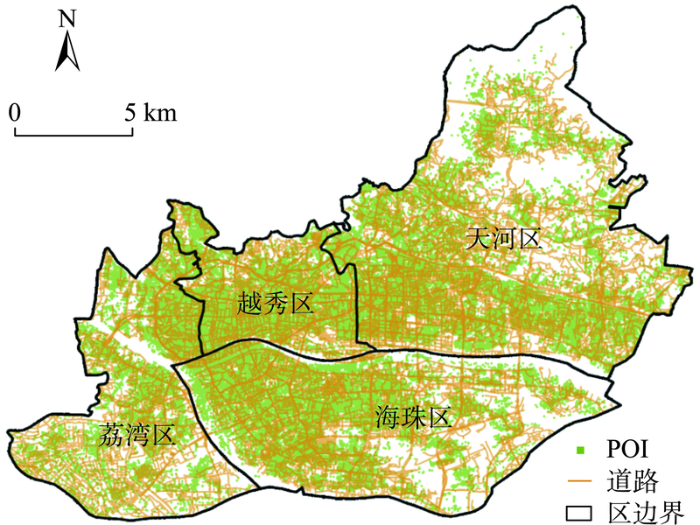
广州中心城区(包括荔湾、越秀、天河和海珠区)承担广州市科教文创和综合服务等中心职能,选作本文的研究范围(图1)。在空间维度上按照300 m×300 m方格网,将研究范围划分为4214个单元。之所以选取300 m×300 m 方格网,是为了更好地匹配中心城区的街区空间尺度,以实现街区尺度上的城市活力时空可视化及其与建成环境关系的研究目标。对市域范围的城市活力研究大多选取500 m×500 m或1000 m×1000 m作为街区尺度[6,10,29]。考虑到本文聚焦中心城区,道路网更加密集,300 m对应老城区内次干道/支路的间距。同时,300 m×300 m 方格网接近10 hm2,是控制性详细规划管理中相关指标的常用单位。
图1
1.2 数据来源
1.2.1 百度热力图
值得注意的是,百度热力指数包括在家或工作地的百度用户。按照Jacobs[1]的定义,这些用户及其活动并不能归类于街区生活,故不应纳入城市活力的计算。但是,家与工作地作为城市的重要场所,是居民24 h时空行为的重要锚点。一个集聚居民的街区被认为是有活力的(当居民外出活动时就会促进街区活力),而一个空置率高的街区往往缺乏活力。并且相对而言,居民在户外使用百度相关移动应用程序(特别是百度地图)的概率更高,因此更大程度反映街区活力。更为重要的是,百度热力图每15 min更新1次,从而能较好揭示城市活力的时空动态变化特征[29]。总体上,虽然百度热力图不是测度城市活力的完美指标,但仍相对合理并在相关研究中得到证实[10,29]。
本文首先通过爬虫程序接入百度地图动态API,以1 h为时间间隔,采集广州中心城区2021年3月22—26日为期5个工作日7:00~23:00的热力图,共计85张。定义7:00~18:00为白天时段,18:00~ 23:00为夜间时段,取各时段热力指数均值表征各空间单元城市活力,分别计算各空间单元工作日白天与夜间的城市活力(表1)。图2分别展示广州市中心城区在工作日白天与夜间的城市活力空间。总体来看,白天的城市活力高于夜间的城市活力。一方面,中心城区作为全市的就业中心,白天集聚全市(包括中心城区与外围地区)居民的活动,从而提升城市活力;相反,夜间外围地区居民回到住处,城市活力有所下降。另一方面,夜间居民回到住处后,使用百度相关移动应用程序的概率有所下降,这也一定程度说明百度活力指数能较好反映街区活力的动态变化。
表1 变量定义与描述性统计
Tab.1
| 变量 | 描述 | 平均值 | 标准差 | 最小值 | 最大值 | |
|---|---|---|---|---|---|---|
| 城市活力 | 百度热力指数 | 381.30 | 79.33 | 36.28 | 531.75 | |
| 建设强度 | 建筑密度 | 建筑基底面积/用地面积 | 0.43 | 0.19 | 0 | 1.00 |
| 容积率 | 建筑总面积/用地面积 | 2.46 | 1.40 | 0 | 9.41 | |
| 功能性质 | 居住设施密度 | 居住设施POI密度(个/km2) | 22.82 | 25.22 | 0 | 193.00 |
| 办公设施密度 | 办公设施POI密度(个/km2) | 112.48 | 120.26 | 0 | 1232.00 | |
| 休闲设施密度 | 休闲设施POI密度(个/km2) | 141.18 | 160.45 | 0 | 1026.00 | |
| 功能混合度 | 0.56 | 0.20 | 0.11 | 1.00 | ||
| 交通可达性 | 路网密度 | 道路长度/用地面积(km/km2) | 0.94 | 1.58 | 0 | 11.50 |
| 公交密度 | 公交线路数量×公交站点数量/用地面积(个/km2) | 78.82 | 69.69 | 0 | 431.69 | |
| 地铁可达性 | 网格中心到最近地铁站的直线距离(km) | 0.62 | 0.44 | 0.32 | 1.20 | |
图2
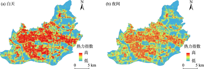
图2
广州市中心城区城市活力空间
Fig.2
Spatial distribution of urban vitality in central Guangzhou City
1.2.2 建成环境要素
采集建筑矢量数据、路网数据、POI数据,分别从建设强度、功能性质、交通可达性3个维度表征建成环境特征。其中,2021年广州市建筑矢量数据和城市路网数据来自于OpenStreetMap,POI数据来自高德地图。如表1所示,建筑矢量数据分别从2D和3D视角测度各空间单元的建设强度,包括建筑密度和容积率指标。城市路网数据测算各空间单元的交通可达性,包括路网密度和公交密度指标。居住、工作、游憩、交通是城市空间的四大基本功能。提取POI数据并归类为居住设施、办公设施、休闲设施(餐饮、购物、生活设施、旅游景点、公园绿地等)3类,分别对应居住、工作、游憩基本功能。各类设施密度通过集聚特征反映各空间单元的功能性质,其熵值则测度各空间单元的功能混合度。
1.3 GBDT模型
式中:
初始化决策树:
决策树
式中:
进一步计算梯度下降步长为:
将计算结果更新至模型,并引入学习率ξ,控制每棵树的贡献。表达式如下:
参照上述流程,本文按照工作日白天与夜间分别构建模型。将数据以8∶2的比例随机划分为训练集和测试集,利用R语言“gbm”包拟合模型。在GBDT模型参数中,设置学习率(控制拟合过程每一步的权重,用于提高模型准确率)为0.001、最大树深与最小叶子权重(控制模型的复杂程度,用于防止过拟合)为10和0.8,最大迭代回归数为2000,其余参数设为默认值,分布函数选择高斯分布。模型采用5折交叉验证,经验证得知,最佳拟合树数为1664,模型测试准确率达到78.6%。可以认为,取得良好的准确率,且不存在过拟合问题。
2 城市活力与建成环境的关系
2.1 建成环境要素的相对重要性
自变量的相对重要性表现建模过程中各自变量对结果预测的贡献程度,所有自变量的相对重要性之和为100%。依据重要性程度从大到小依次对各指标排序(表2),重要性程度越高则表明该建成环境要素对城市活力影响越大。
表2 建成环境要素对城市活力的相对重要性
Tab.2
| 变量 | 工作日白天 | 工作日夜间 | ||||
|---|---|---|---|---|---|---|
| 重要性/% | 排名 | 重要性/% | 排名 | |||
| 建设 强度 | 建筑密度 | 3.79 | 7 | 5.36 | 4 | |
| 容积率 | 33.29 | 1 | 34.79 | 1 | ||
| 功能 性质 | 休闲设施密度 | 24.16 | 2 | 30.38 | 2 | |
| 居住设施密度 | 0.22 | 9 | 0.10 | 9 | ||
| 办公设施密度 | 6.16 | 4 | 0.57 | 8 | ||
| 功能混合度 | 2.61 | 8 | 2.18 | 7 | ||
| 交通可达性 | 路网密度 | 4.35 | 6 | 3.91 | 6 | |
| 公交密度 | 20.75 | 3 | 18.63 | 3 | ||
| 地铁可达性 | 5.37 | 5 | 4.08 | 5 | ||
(1) 建设强度。具体来看,容积率是预测城市活力最重要的指标,其相对重要性程度稳定在33%~35%之间,远高于其他指标。这说明城市活力本质上表现为居民与建成环境要素的相互作用,展现一个地方为满足居民活动提供设施与空间等要素的能力。相对而言,建筑密度对塑造城市活力的贡献相对有限。特别是在建设用地稀缺的大城市,建设空间的垂直增长相对于水平增长对城市活力更为重要。值得注意的是,建筑密度的相对重要性程度在夜间明显高于白天。这可能与广州中心城区遍布的城中村有关,高建筑密度的城中村成为许多都市白领的住处。
(2) 功能性质。休闲设施密度对于城市活力强度塑造的重要程度要远超出办公与居住设施密度,其相对重要程度白天达到了20%以上,在夜间甚至达到了30%以上。办公设施密度对塑造白天城市活力的贡献高于夜间,这也与居民每天的活动时间规律相符合(即白天工作,夜间外出餐饮、购物、娱乐等)。其中,办公设施密度对塑造工作日白天城市活力的贡献达到6.16%(排在第4位),这说明办公空间的集聚是促进白天城市活力的重要举措。
(3) 交通可达性。路网密度、公交密度、地铁可达性3个指标均对城市活力的塑造起到较大作用。尤其是公交密度,其相对重要性程度在工作日白天、夜间分别达到20.75%、18.63%,均列在所有指标的第3位。总体看,3个指标对工作日白天城市活力预测的贡献度明显高于工作日夜间。
2.2 建成环境要素的非线性关系与阈值效应
GBDT算法中内嵌的部分依赖图(partial dependence plot)可以展现模型中自变量对模型拟合的边际效应,即在假设其他建成环境指标不发生变化的前提下,探究某个建成环境指标与城市活力间的关系。结合上述分析,从建设强度、功能性质、交通可达性3个维度各选取对城市活力预测边际效应较大的2个指标,展示城市活力与建成环境的非线性关系与阈值效应(图3~5)。
图3
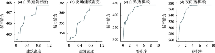
图3
建设强度与城市活力的非线性关系
Fig.3
Nonlinear associations between urban vitality and key development intensity variables
图4
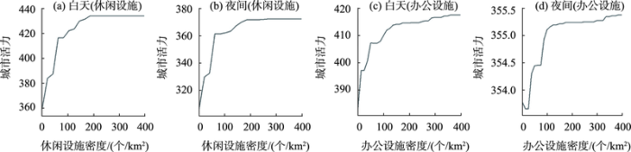
图4
功能性质与城市活力的非线性关系
Fig.4
Nonlinear associations between urban vitality and key function variables
图5
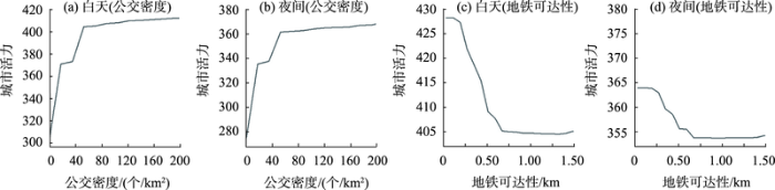
图5
交通可达性与城市活力的非线性关系
Fig.5
Nonlinear associations between urban vitality and key transport accessibility variables
(1) 建筑密度与城市活力的非线性关系。由于建筑密度高于0.7以上的格网相对缺少,主要分析小于0.7范围内的建筑密度与城市活力的关系。总体上,建筑密度在工作日白天和夜间对城市活力的影响差异较大(图3a, 3b)。在白天,建筑密度与城市活力的关系可大致分为2个区间,存在1个阈值(0.3)。在小于0.3范围内,建筑密度对城市活力的影响呈现出大幅度的上升趋势;在0.3~0.7范围内,建筑密度与城市活力近似为正向的线性关系,增长的边际效应低。在夜间,建筑密度与城市活力的关系波动性较大。在小于0.3范围内,建筑密度对城市活力的影响呈现明显的不规律性;在0.3~0.75范围内,建筑密度对城市活力的影响显著上升至峰值。若不考虑城中村的特殊性,可以认为0.3的建筑密度是城市开发中促进城市活力的较为合理指标。
(2) 容积率与城市活力的非线性关系。由于容积率高于6.0的格网相对缺少,主要分析0~6.0范围内容积率与城市活力的关系。总体上,容积率在工作日白天和夜间对城市活力的影响趋势相似,存在2个阈值(1.0和3.5)。具体上,在0~1.0范围内,容积率对城市活力的影响呈大幅度上升趋势;在1.0~3.5范围内,容积率与城市活力近似为正向的线性关系,增长的边际效应递减;在3.5~6.0范围内,容积率对城市活力的影响仍呈现正向的线性关系,边际效应进一步递减(图3c, 3d)。这进一步证实,开发强度在一定取值范围内(特别是0~3.5范围内)的增加可以显著提升城市活力,但超出临界值后其提升城市活力的作用逐步得到抑制[29]。因此,在大城市的垂直开发中,可以认为CBD等核心地段以外地区的容积率应控制在合理的区间,以保证城市活力的有效提升。
(3) 休闲设施密度与城市活力的非线性关系。由于休闲设施密度高于400个/km2的格网相对缺少,主要分析0~400个/km2范围内休闲设施密度与城市活力的关系。整体上,休闲设施密度在工作日白天和夜间对城市活力的影响趋势相似,存在2个阈值(60个/km2与180个/km2)。具体来说,在0~60个/km2范围内,休闲设施密度对城市活力的影响呈大幅度上升趋势;在60~180个/km2范围内,休闲设施密度与城市活力近似为正向的线性关系,增长的边际效应递减,并在180个/km2达到较高阈值(图4a, 4b)。基于此,可以认为60个/km2与180个/km2的休闲设施密度是非公共服务功能片区(如居住区)和公共服务功能片区较为合理的休闲配套指标,以促进城市活力。
(4) 办公设施密度与城市活力的非线性关系。由于办公设施密度高于400个/km2的格网相对缺少,主要分析0~400个/km2范围内办公设施密度与城市活力的关系。总体上,办公设施密度在工作日白天和夜间对城市活力的影响差异明显(图4c, 4d)。在白天,办公设施密度与城市活力的关系可大致分为3个区间,存在2个阈值(50个/km2和120个/km2)。在0~50个/km2范围内,办公设施密度对城市活力的影响呈大幅度上升趋势;在50~120个/km2范围内,办公设施密度与城市活力近似为正向的线性关系,增长的边际效应递减增速放缓,并在120个/km2达到较高阈值。在夜间,办公设施密度与城市活力的关系波动性较大且水平相对较低,这与居民的活动规律相符合。基于此,50个/km2和120个/km2的办公设施密度是非就业区和就业区较为合理的办公设施指标,以保证城市活力的有效提升。
(5) 公交密度与城市活力的非线性关系。由于公交密度高于200个/km2的格网相对缺少,主要分析0~200个/km2范围内公交密度与城市活力的关系。总体上,公交密度在工作日白天和夜间对城市活力的影响趋势相似,存在3个阈值(20、40、60个/km2)。具体上,在0~20个/km2范围内,公交密度对城市活力的影响呈大幅度上升趋势;在20~40个/km2范围内,公交密度与城市活力近似为正向的线性关系,增长的边际效应递减增速放缓;在40~60个/km2范围内,公交密度对城市活力的影响再次显著提升,并在60个/km2达到较高阈值(图5a, 5b)。这一变化趋势可能与格网功能有一定关系,相较于居住区,商业等公共服务区需要更高的公交密度支撑大规模人口集聚与扩散[28,34]。
(6) 地铁可达性与城市活力的非线性关系。由于广州中心城区具有较好的地铁覆盖率,离最近地铁站距离1.5 km以上的格网相对缺少,主要分析0~1.5 km范围内地铁可达性与城市活力的关系。总体上,地铁可达性在工作日白天和夜间对城市活力的影响趋势相似,并以0.75 km为阈值。在0~0.75 km范围内,离最近地铁站距离对城市活力的影响大致呈显著负向的线性关系;距离地铁站0.75 km以上,城市活力稳定在较低水平(图5c, 5d)。对城市活力的影响趋于稳定在较低水平。Yang等[29]对深圳的研究发现,离地铁站距离阈值为0.86 km(原始距离0.65 km+0.3 km×
3 结论与讨论
如何通过建成环境营造提升城市活力,一直是城市地理和城乡规划研究与实践的重要议题。本文通过采集广州中心城区的百度热力图、建筑矢量数据、路网数据、POI数据等多源空间大数据,以300 m×300 m格网为研究单元,应用GBDT模型探究建设强度、功能性质和交通可达性3个维度的建成环境要素对城市活力影响的非线性关系和阈值效应,并对比在工作日白天与夜间的影响差异。研究发现:(1) 容积率对城市活力塑造的相对重要性最高,其次是休闲设施密度与公交密度,且白天与夜间的差异不显著。(2) 各建成环境要素与城市活力之间均存在非线性关系和阈值效应,且部分建成环境要素白天与夜间的差异较明显。
一方面,本文挑战对城市活力与建成环境全局性的预设线性或广义线性关系假设,通过空间大数据与机器学习方法创新,从微观尺度上探究各建成环境要素对城市活力影响在边际效应维度的局部特征;另一方面,本文揭示了建成环境要素对城市活力影响存在白天与夜间的时间异质性。研究结论能够为建成环境规划决策以塑造和提升24 h的街区活力提供更精细化的参考依据,特别是建成环境要素的取值范围能更好地指导空间资源的优化配置(如高于最高阈值时,资源的边际效应下降;低于最低阈值时,资源的边际效应得不到触发)。具体来看,本文发现相较于功能混合度,合理的开发建设强度、集聚的休闲与办公设施、公交导向交通发展,更有助于塑造充满活力的城市。同时,开发建设强度、集聚的休闲与办公设施、公交导向交通的相关指标均存在阈值,可为城市建成环境规划与管理以提升城市活力的指标取值范围提供参考依据。
当然,本文发现的各具体建成环境要素的阈值还有待后续研究的检验。一方面,在对城市活力的测度上,可以尝试收集能够表征不同维度(如经济活力、社会活力等)城市活力的多源数据;另一方面,在建成环境的测度上,也可以采集更多可能影响人及其活动时空分布的建成环境要素(如蓝绿空间、建筑形态等)。在对城市活力与建成环境全面测度的基础上,通过更多城市案例的研究检验二者的非线性关系和阈值效应,也将进一步提升研究的可靠性与代表性。
参考文献
Making a city: Urbanity, vitality and urban design
[J].DOI:10.1080/13574809808724418 URL [本文引用: 1]
Check-in behaviour and spatio-temporal vibrancy: An exploratory analysis in Shenzhen, China
[J].DOI:10.1016/j.cities.2018.01.017 URL [本文引用: 2]
Cities, productivity, and quality of life
[J].
DOI:10.1126/science.1209264
PMID:21798941
[本文引用: 1]

Technological changes and improved electronic communications seem, paradoxically, to be making cities more, rather than less, important. There is a strong correlation between urbanization and economic development across countries, and within-country evidence suggests that productivity rises in dense agglomerations. But urban economic advantages are often offset by the perennial urban curses of crime, congestion and contagious disease. The past history of the developed world suggests that these problems require more capable governments that use a combination of economic and engineering solutions. Though the scope of urban challenges can make remaining rural seem attractive, agrarian poverty has typically also been quite costly.
基于大数据的上海中心城区建成环境与城市活力关系分析
[J].
DOI:10.13249/j.cnki.sgs.2020.01.008
[本文引用: 3]
运用大众点评数据、出租车到达数据与文化设施POI数据测度城市活力的经济、社会和文化维度,在街区和街道层面分析城市活力的空间结构特征,建立计量模型分析城市建成环境对城市活力的影响关系。结果表明:①上海中心城区城市活力表现出明显的空间差异,主要表现为由中心向四周递减、浦西优于浦东的总体特征;②街区和街道尺度影响城市活力的建成环境因素存在差异;③街区尺度建成环境对城市社会、经济和文化活力的影响存在差异:提升人口密度对经济活力具有正面影响,过高的人口密度可能不利于社会和文化活力发展;增加POI密度、路网密度和POI混合度有利于城市活力的提升;建筑层数和建筑密度的增加会降低街区的社会活力和文化活力,但会提升街区的经济活力;交通可达性有利于经济活力的提升。
Relationship between built environment and urban vitality in Shanghai downtown area based on big data
DOI:10.13249/j.cnki.sgs.2020.01.008
[本文引用: 3]
Research on urban vitality has drawn more attention from different disciplines and perspectives such as urban geography, urban planning and urban government. Urban vitality is not only an important symbol of urban sustainable development, but also an important factor for cities to retain high-skilled talents, which could improve the competitiveness of the city. Studying urban vitality is conducive for us to re-understanding the city in a new perspective and improving urban human-oriented planning and management for the government, especially for some megacities and international cities which contain a large population. Urban vitality, consisting of economic vitality, social vitality and cultural vitality, reflects the level of urban development capacity and quality of life, which is also closely related to the citizens. In order to discover the urban vitality in Shanghai, this paper uses multi-source data, including dianping’s data which counts the number of businesses in the studying area to reflect the economic vitality, urban taxi arrival data in one week to reflect the social vitality and cultural facilities data in the studying area to reflect cultural vitality, to measure urban vitality from two scale: both block and sub-district level. Based on this comprehensive measurement, this article intends to analyze the spatial outcome characteristics of urban vitality in different blocks and sub-districts. This article also establishes a regression models for analyzing the impact mechanism of urban built environment which consists of multiple elements on urban vitality. It is found that the urban vitality of Shanghai is higher in the central area, decreasing from the central area to the surrounding area in the city. In the meanwhile, the value of urban vitality in Puxi area is higher than Pudong area, which means the daily activities and communication in Puxi area are more dynamic than these in Pudong area. Apart from differences between Puxi and Pudong areas, there are also distinctions regarding to the factors of built environments effecting the urban vitality between block level and street level. On the block level, it is found that the built environments effect significantly to different types of urban vitality and the comprehensive vitality. What’s more, for each vitality, the effect shows in different ways. Specifically, the increase of population density will influence the urban vitality by firstly in an active way then in a passive one. Especially for social and cultural vitality, the high density of population is not beneficial. For the facilities, increase of POI density and road network density presenting completeness and POI mixing degree presenting the variety of land use will promote all kinds of the vitality and comprehensive vitality. In the respect of the design, the increase of average building layers and building density will reduce the social vitality and cultural vitality, but will enhance the economic vitality and comprehensive vitality of the block at the same time. And in terms of the access to public transportation, the distance to the nearest bus station will increase the economic vitality of the block. According to the discoveries about the spatial pattern and the effecting factors of urban vitality, this article proves improving the built environment is meaningful to the development of urban.
建成环境对城市活力影响的时空异质性研究: 基于大数据的分析
[J].
DOI:10.13249/j.cnki.sgs.2022.02.009
[本文引用: 4]
城市地理与城乡规划一直关注建成环境对城市活力的影响,但鲜有研究揭示该影响的时空异质性。城市活力表现为居民在实体空间上的分布及其活动,并呈现时间动态变化特征。通过采集广州市中心城区新浪微博签到数据以及建成环境大数据,在1 km×1 km方格网、2 h时间段的时空单元上可视化城市活力的时空动态变化特征,基于时空地理加权回归模型 (GTWR) 揭示区位、功能混合度与密度对城市活力影响的时空异质性,并对比工作日与双休日的差异。研究发现:① 广州中心城区城市活力呈现东西带状的“多节点”空间格局,在24 h内经历“分散-集聚-进一步集聚-分散”的时空动态变化。② 区位、功能混合度与密度对城市活力的边际效应表现出空间和时间双重维度的不稳定性。③ 由于居民活动的时空约束不同,城市活力时空特征及其建成环境影响在工作日与双休日存在差异。
The spatio-temporal impacts of the built environment on urban vitality: A study based on big data
DOI:10.13249/j.cnki.sgs.2022.02.009
[本文引用: 4]
Urban vitality reflects human activities and their interactions with spatial entities, which exhibits both spatial and temporal variations. However, the spatio-temporal variations have not been well addressed in existing research on the impacts of the built environment on urban vitality. Based on a collection of Sina Weibo check-in records and POI-based built environment data in central Guangzhou, this research visualizes the urban vitality at the scale of 1 km×1 km grid and 2 h period over one day. Geographically and temporally weighted regression (GTWR) are used to unveil the influence of location, density, and diversity on the urban vitality and their spatiotemporal heterogeneity. The difference between urban vitality and the impacts of the built environment on weekdays and on weekends have also been examined. The results show that: 1) the urban vitality in central Guangzhou extends along the east-west strip, with White Goose Pool, Beijing Road, Shangxiajiu Road, Zhuajing Newtown, Pazhou as the agglomerations. In one day, the urban vitality experiences dynamic changes from relatively scattered to agglomeration during the daytime and keep further agglomeration till midnight. 2) Although the location, density, and diversity significantly influence urban vitality, their impacts vary across space and time over a 24-h period. Generally, distance to the city center is negatively associated with urban vitality, while diversity and the density of leisure, housing, transport, and other facilities are positively associated with urban vitality. 3) Due to a lower activity constraint of space and time on weekdays and on weekends, their urban vitality and the spatio-temporal impacts of the built environment are obviously different.
Elaborating spatiotemporal associations between the built environment and urban vibrancy: A case of Guangzhou City, China
[J].DOI:10.1007/s11769-022-1272-6 URL [本文引用: 4]
基于居民时空行为的社区日常活动空间测度及活力影响因素研究: 以南京市沙洲、南苑街道为例
[J].
DOI:10.18306/dlkxjz.2021.04.004
[本文引用: 1]
新时期人本导向的社区生活圈规划转型关注居民的日常活动对社区空间的利用情况,从而反映出居民对社区公共服务设施的使用需求。但目前研究较少关注不同类型居民的差异化时空行为特征,不能有效应对社区居民的差异化需求。论文结合行为地理学的理论,利用手机信令数据,基于居民出行活动的频率和密度测度其核心活动空间和弹性活动空间,分析不同类型人群日常活动特征。以南京市沙洲和南苑街道为例,划定不同社区中,青少年、青年、中年和老年群体的日常活动空间,并从日常活动范围和活力的视角分析居民对社区空间利用的基本特征及群体间差异。研究结果表明,居民的日常活动空间表现出层次性、共享性和方向性,且不同年龄群体的日常活动空间存在显著差异;进一步利用相关性检验分析不同群体社区活力的影响因素,提出考虑不同群体活动空间和设施需求的公共服务设施差异化供给策略。研究有助于完善基于居民时空间行为测度社区日常活动空间的方法,丰富对社区居民差异化行为需求的认知。实证研究的结论对基于居民差异化空间和设施需求的社区公共服务设施配置具有一定指导意义。
Measurement of community daily activity space and influencing factors of vitality based on residents' spatiotemporal behavior: Taking Shazhou and Nanyuan streets in Nanjing as examples
DOI:10.18306/dlkxjz.2021.04.004
[本文引用: 1]
In the new era of China's development, people's needs for living space have become diversified. At the community level, the transformation of the planning of a human-oriented community life circle needs to pay attention to residents' daily activities to use the community space, thereby reflecting residents' use of community public service facilities. This demands to identify the daily activity space of residents. However, current research has paid little attention to the differentiated spatial and temporal behavior characteristics of different types of residents, and cannot effectively respond to the diverse needs of community residents. Based on the theory of behavioral geography, this research proposed a method of using mobile phone signaling data to measure the core activity space and flexible activity space based on the frequency and density of residents' travel activities, and then analyze the characteristics of daily activities of different types of people. Taking Shazhou and Nanyuan streets in Nanjing City as examples, the daily activity space of adolescent, youth, middle-aged, and elderly resident groups in different communities was delineated, and the basic characteristics of residents'use of community space were analyzed from the perspective of daily activity range and vitality differences among groups. The research results show that the daily activity space of residents shows hierarchical, sharing, and directional features, and there are significant differences in the daily activity space of different age groups. Further, by using the correlation test to analyze the influencing factors of the vitality of different groups of the communities, we proposed a differentiated supply strategy for public service facilities that considers the activity space and facility needs of different groups. This research is helpful for improving the method of measuring the daily activity space of community based on the spatiotemporal behavior of residents, and enriching the understanding of the diverse behavior needs of community residents. The conclusions of the empirical research have certain guiding significance for the allocation of community public service facilities based on residents' diverse space and facility needs.
Measurements of POI-based mixed use and their relationships with neighbourhood vibrancy
[J].DOI:10.1080/13658816.2016.1220561 URL [本文引用: 2]
Evaluating and characterizing urban vibrancy using spatial big data: Shanghai as a case study
[J].DOI:10.1177/2399808319828730 URL [本文引用: 2]
基于签到数据的城市活动时空间动态变化及区划研究
[J].
DOI:10.13249/j.cnki.sgs.2015.02.151
[本文引用: 2]
借助新浪微博,引入位置服务大数据,以南京市为例,从时间、空间、活动3个方面分析城市活动空间的动态变化,并在掌握变化规律的基础上进一步划分城市活动区域。研究发现:传统的作息规律仍然支配着人们的签到活动,时间与活动内容间的对应关系仍然存在;居民活动在工作日、休息日与节假日,以及主城与外围地区存在差异;城市活动空间在一天内经历了相对分散-集聚-进一步集聚-分散-相对集聚的动态变化;城市活动区域可以划分为就业活动区、居住活动区、休闲活动区、夜生活活动区,及综合活动区;活动功能区呈现出混合化与边界模糊化的特征。
The dynamic changes of urban space-time activity and activity zoning based on check-in data in Sina web
DOI:10.13249/j.cnki.sgs.2015.02.151
[本文引用: 2]
Since 1990s, information and communication technologies (ICTs) have experiecned a rapid development over the world. Information and communication devices have almost penetrated into each aspect of people’s daily life, and thus become the necessities in the modern world. Under this advancement, the inner relationship among activities, time and location has been theoretically changed because of a serious of the responding tele-activities. However, we still have little knowledge from the empirical studies due to the lack of data. Besides, as a part of urban social space analysis, a dynamic analysis of urban activity space is even scarce, albeit with its importance in understanding the undergoing and future changes in the E-society. Especially in China where is under the socio-economic transition, understanding residents’ own need and their real-time activity as well as the influence of ICTs on activity space are quite necessary for the future urban management and planning. With the aid of Location-based service (LBS), Global Positioning System (GPS) and other applications, ICTs helps to record people’s real space-time activity, which is one of the main sources of big data in recent research. Among them, given by the soaring popularity of online social network such as Sina micro-blog (the most influential social networking platform in China) and the LBS check-in application, the check-in data undoubtedly provide a real-time big data for the study of urban activity space. Based on this understanding, this article tries to analyze the dynamic changes of urban space-time activity focused on activity, time, and location, using the LBS checking-in data from Sina micro-blog. The results show that: 1) although some research argued that residents’ activity schedule would be more flexible by the help of ICTs, in this study we find that the traditional routine still dominate in residents’ check-in activities, and thus the rhythm of check-in activities could be used to reflect the corresponding relationship between time and activity; 2) there are differences of residents’ check-in activity between on working days, weekends, and holidays, as well as between in downtown and in outskirts, which reveals the difference of daily activities in reality; 3) in a day urban activity space experience dynamic changes, specifically, varied from relative disperse to agglomeration in the morning (6-12 O’clock) and keeps further agglomeration till the afternoon (12-18 O’clock); while encounters dispersion in the evening (18-24 O’clock), though with a relative agglomeration in the night (0-6 O’clock); 4) according to the dynamic changes, activity zones are subdivided into office area, bedroom area, leisure area, nightlife area, and multifunctional area; 5) these activity zones could be generally characterized as hybrid, within a blurred boundary.
Progress of e-development in China since 1998
[J].DOI:10.1016/j.telpol.2017.03.001 URL [本文引用: 1]
“大数据”热潮下人文地理学研究的再思考
[J].
DOI:10.11821/dlyj201505001
[本文引用: 1]
伴随着移动通信技术的快速发展以及定位应用程序的普及,带有地理空间信息的数据成为“大数据”中的重要部分,为人文地理学研究的发展提供了新的机遇,也契合了人文地理学“计量转向”与“社会转向”的发展规律,以及人文地理学人本主义的发展趋势。但同时,人文地理学者也面临着数据决定论、数据分析方法准备不足以及数据自身缺陷所带来的危机与挑战。在“大数据”热潮下,无论是定量研究还是定性研究,“大数据”还是“小数据”的研究,都应当给予同样的重视,数据规模与数据的采集、分析和阐述并无很大的关联。并且,还需要警惕由于数据垄断可能带来研究的“数字鸿沟”,并呼吁人文地理学研究在研究方法与内容等方面与其他学科进行更多的跨学科合作。
Rethinking human geography in the age of big data
DOI:10.11821/dlyj201505001
[本文引用: 1]
<p>The rapid development of information and communication technologies and the wide use of smart devices in people′s daily life have generated a large amount of data-the big data. The information exploration has not only greatly influenced our life, work and thinking, but also presented a new paradigm of social science research, that is, from data-scarce to data-rich study, from static to dynamic analysis, from relatively simple hypothesis and model to comprehensive simulations and theory. Especially these big data with spatial information brings opportunities for human geography. Big data meets geography’s quantitative revolution and social transition and should not be overlooked, since it provides a large amount of timely and detailed data of human behavior. In the meantime, geographers also face risks and challenges. Firstly, geographers require careful rethinking with respect to the philosophy of science and consideration on the important distinction between data and knowledge. Data never speak for themselves and require contextual knowledge with respect to analysis and interpretation. Secondly, it is hard to say that geographers have well underprepared for big data. Geographers have long been used to the traditional statistical methods which are designed with regard to data-scarce science. New methods of handling and analyzing data sets that consist of millions or billions of observations are urgently needed. Thirdly, despite the emerging data deluge, there are a number of ethical and security challenges in working with these data. How to define the scale and boundary of data is also a challenge, since the data are growing all the time. Then this paper points out that emphasis should be equally placed on quantitative and qualitative research and small-data and big-data research. Geographers should pay attention to the "digital divide" since access to big data is limited, and geographers should cooperate with scholars in other academic fields.</p>
Looking at Barcelona through Jane Jacobs's eyes: Mapping the basic conditions for urban vitality in a Mediterranean conurbation
[J].DOI:10.1016/j.landusepol.2018.04.026 URL [本文引用: 1]
Urban form breeds neighborhood vibrancy: A case study using a GPS-based activity survey in suburban Beijing
[J].DOI:10.1016/j.cities.2017.11.008 URL [本文引用: 1]
基于LBS定位数据的建成环境对街道活力的影响及其时空特征研究
[J].
Influence of built environment on street vitality and its spatiotemporal characteristics based on LBS positioning data
DOI:10.22217/upi.2018.495 URL [本文引用: 1]
Evaluating cities' vitality and identifying ghost cities in China with emerging geographical data
[J].DOI:10.1016/j.cities.2017.01.002 URL [本文引用: 2]
空气污染对城市活力的影响及其建成环境异质性: 基于大数据的分析
[J].
DOI:10.11821/dlyj020200685
[本文引用: 1]
建设充满活力的城市空间得到地理和城乡规划学者的广泛关注。随着空气污染问题的加剧,空气质量影响居民在城市空间中的活动,但鲜有研究考察空气污染与城市活力的定量关系。基于广州市2019年新浪微博签到记录、日气象和空气质量数据、以及建成环境数据,本研究构建以街道为空间单元、以天为时间单元的面板数据,通过标准差椭圆(SDE)以及面板回归模型测度空气污染对城市活力的抑制效应以及该抑制效应在不同建成环境上的异质性。研究得到以下结论:① 城市活力SDE面积随空气质量指数(AQI)上升而收缩,轻度污染和中度污染的城市活力SDE面积仅为空气质量优的约80%和30%。② 运用空间面板回归模型控制街道的空间关联性后,空气质量指数(AQI)对城市活力具有明显负向影响,AQI每增加1个单位,日活动强度减少约0.10次/10 km<sup>2</sup>;当空气质量恶化到中等污染后,AQI每增加1个单位,日活动强度减少约0.14次/10 km<sup>2</sup>。③ 空气污染对城市活力的抑制效应在不同建成环境上存在异质性,POI密度、离城市中心距离强化空气污染对城市活力的抑制效应,而地铁站密度、道路交叉口密度、土地利用混合度则弱化空气污染对城市活力的抑制效应。本研究有助于更好厘清空气污染、建成环境与城市活力的关系,并为优化建成环境以缓减空气污染对城市活力抑制效应提供分析支撑。
The impact of air pollution on urban vibrancy and its built environment heterogeneity: An empirical analysis based on big data
DOI:10.11821/dlyj020200685
[本文引用: 1]
Urban vibrancy describes people’s interactions with urban space. And enhancing urban vibrancy is important for urban sustainable development, and thereby attracts the interest of both geography and urban researchers and policy makers. Although evidence suggests that air pollution may influence people’s out-of-home activity, few studies have quantitatively measured how air pollution depresses urban vibrancy. On the basis of Sina Weibo check-in data and daily weather and air quality data in Guangzhou in 2019 and the built environment of this city, this study compiles samples of city vibrancy in 150 neighbourhoods and 365 days, forming a strongly balanced panel dataset. By Standard Deviational Ellipse (SDE) analysis and both general and spatial panel regression models, this study examines how air pollution negatively influences urban vibrancy and the heterogeneity role of the built environment in this depression effect. Our findings demonstrate that urban vibrancy space varies across different levels of air quality index (AQI). Specifically, the size of SDEs of urban vibrancy when AQI is between 50-150 and 150-200 is about 80% and 30% of that when AQI is no more than 50. After we control the spatial dependence (i.e., spatial autocorrelation), spatial panel regression results reveal that air pollution significantly lowers urban vibrancy. The daily activity intensity decreases 0.10 times per ten kilometers with a one-unit increment in AQI. More seriously, once AQI is above 150, this depression effect grows to 0.14 times per ten kilometers with a one-unit increment in AQI. We also test the heterogeneity role of the built environment in this depression effect. The results indicate that while POI density and distance to city center increase the depression effect, the density of metro stations and interactions and land-use diversity decrease the depression effect. It is evident that the depression effect of air pollution on urban vibrancy is not evenly distributed, varying across neibourhoods with different built environment characteristics. Compared to the city center, the outskirts bear a larger depression effect. Therefore, urban vibrancy space may be more polarized when air quality deteriorates and thus, challenging urban spatial restructuring development. Our spatial panel data analysis at the neighourhood scale improves our understanding of the mechanism among air pollution, built environment, and urban vibrancy, which provides evidence-based support for built environment planning and management at the neighbourhood scale to decrease the depression effect of air pollution on urban vibrancy.
A theoretical framework and methodology for urban activity spatial structure in e-society: Empirical evidence for Nanjing City, China
[J].DOI:10.1007/s11769-015-0751-4 URL [本文引用: 1]
Does block size matter? The impact of urban design on economic vitality for Chinese cities
[J].DOI:10.1177/2399808317715640 URL [本文引用: 1]
基于多源数据的滨水公共空间活力评价研究: 以黄浦江滨水区为例
[J].
Vitality assessment of waterfront public space based on multi-source data: A case study of the Huangpu River waterfront
How block density and typology affect urban vitality: An exploratory analysis in Shenzhen, China
[J].DOI:10.1080/02723638.2017.1381536 URL [本文引用: 2]
Analyzing spatial relationships between urban land use intensity and urban vitality at street block level: A case study of five Chinese megacities
[J].
Seoul's Wi-Fi hotspots: Wi-Fi access points as an indicator of urban vitality
[J].DOI:10.1016/j.compenvurbsys.2018.06.004 URL [本文引用: 1]
Predicting vibrancy of metro station areas considering spatial relationships through graph convolutional neural networks: The case of Shenzhen, China
[J].DOI:10.1177/2399808320977866 URL [本文引用: 5]
Elaborating non-linear associations and synergies of subway access and land uses with urban vitality in Shenzhen
[J].DOI:10.1016/j.tra.2020.11.014 URL [本文引用: 10]
基于百度地图热力图的城市空间结构研究: 以上海中心城区为例
[J].
Research on urban spatial structure based on Baidu heat map: A case study on the central city of Shanghai
基于大数据的生活圈范围与服务设施空间匹配研究: 以北京为例
[J].
DOI:10.18306/dlkxjz.2021.04.001
[本文引用: 1]
生活圈建设是新时代国土空间规划的关键内容之一,生活圈内服务设施配置是做好生活圈规划的首要基础,居民生活圈与服务设施的空间匹配关系也是地理学“人地关系”在城市社区尺度的重要体现。学术界对生活圈与服务设施的匹配关系已有研究,但主要采用问卷调查数据,该类数据存在样本量少、地域覆盖范围小等不足。论文将采用手机信令数据和POI(point of interest)数据等大数据,以北京为例,测定居民生活圈范围和服务设施可达性,并分析两者间的空间匹配关系及其地域分异特征。结果表明:① 居民生活圈呈现多中心结构,其半径由市中心和新城中心至非中心地区递增;服务设施可达性则呈现圈层结构,其水平则由市中心至郊区递减。② 设施可达性水平与生活圈半径的匹配关系整体呈现显著的负相关,即综合设施可达性水平越高则居民生活圈半径越小。③ 空间匹配模式呈现明显地理分异特征,在中心城区、新城中心,服务设施可达性水平与生活圈半径以“高—低”空间匹配关系为主,但中心城区和新城的边缘地区则以“低—低”“低—高”空间匹配关系为主。④ 不同类型设施之间也存在差异,文体和休闲设施的可达性水平与生活圈范围的空间匹配度显著偏低。研究结论可为完善生活圈理论研究提供新实证案例,并可为生活圈空间规划提供决策参考。
Spatial match between residents' daily life circle and public service facilities using big data analytics: A case of Beijing
DOI:10.18306/dlkxjz.2021.04.001
[本文引用: 1]
Residents' daily life circle is one of the key issues in relation to the national spatial planning in the "new era". Supply of public service facilities is the primary condition for plan-making of this type of circle. Spatial match between residents' daily life circle and public service facilities reveals the human-environment relationship at the community level. There exist many studies on spatial match between residents' daily life circle and public service facilities. However, the existing findings are mainly based on survey data, which have disadvantages such as insufficient samples, small geography coverage, and so on. This study investigated the spatial match between residents' daily life circle and public service facilities in large cities by taking Beijing as an example. Using mobile phone data and point-of-interest (POI) data collected in 2018, this study measured the spatial range of residents' daily life circle and accessibility of public service facilities, and analyzed the relationship between the spatial range of residents' daily life circle and accessibility of public service facilities by the bivariate spatial autocorrelation method. It also analyzed the geographical variations in the relationship. The results of analysis show that residents' daily life circle has a multi-centric structure at the city level. The length of radius of the circle increases from the central areas to the periphery. Accessibility of public service facilities is featured with a zonal structure but its level decreases with the distance away from the centers. The level of accessibility is negatively related with radius of the circle, which means that the higher level of accessibility, the smaller radius of the circle. There are geographical variations in the relationship. The relationship is "high-low" in the city center and new town centers, but dominated by "low-low" and "low-high" pattern in the fringe of the city center and new town centers. There are also variations in the relationship between different types of public service facilities. For the cultural and leisure facilities, the degree of spatial match between residents' daily life circle and public service facilities is obvious lower than other facilities. The conclusion of this research provides new evidence for residents' daily life circle study, and has policy implications for residents' daily life circle planning.
上海市中心城区夜间活力的空间特征研究
[J].
A study on the spatial characteristics of nighttime vitality in the city center of Shanghai
基于街景数据的建成环境与街道活力时空分析: 以深圳福田区为例
[J].
DOI:10.13249/j.cnki.sgs.2021.09.005
[本文引用: 3]
建成环境对街道活力的影响是国内外城市研究的热点议题。然而,对于建成环境要素的测度与评估多偏重于二维建成环境指标,尚未充分挖掘三维建成环境指标。以深圳市福田区为例,采用街景数据、路网数据、POI数据及移动互联网位置服务数据,建立周末分时段模型,探讨商业街道和生活街道活力的时空间分布特征及建成环境对其产生的影响。结果表明:① 商业街道上居民全天活动的峰值时段为18:00~20:00,生活街道上居民全天活动的峰值时段为11:00~13:00。② 深圳市福田区街道活力总体呈现多中心结构,随时间变化显现出明显的空间差异。③ 不同的建成环境指标对街道活力的作用时段与影响程度存在差异。提高功能混合度有利于提升商业街道凌晨、上午和夜间的活力及生活街道午后和傍晚的活力;过宽的相对步行宽度对生活街道活力提升有抑制作用,更安全的步行环境对商业和生活街道夜间活力提升有促进作用;界面连续程度高的商业街道午后及夜间的活力更强,界面多样性丰富的生活街道白天活力更强。
Spatio-temporal analysis of built environment and street vitality relationship based on street-level imagery: A case study of Futian District, Shenzhen
DOI:10.13249/j.cnki.sgs.2021.09.005
[本文引用: 3]
The last decades have witnessed a steady increase in studying urban vitality. However, the information that could depict 3D space has not been included in studies. This research attempts to incorporate street view imagery data to elaborate the spatiotemporal variability of vibrancy in Futian District, Shenzhen. As for the street-level physical environment, attributes are extracted from street view images by deep machine-learning algorithms SegNet. 2D built environment indicators of streets were extracts from the Open Street Map and POI points. A multivariate econometric are framed to examine the association between urban environment and the vitality at the street level of commercial streets and residential streets. The results showed that: 1) The peak hours of activity on commercial streets are 18:00 to 20:00, and the peak hours of activity on living streets are 11:00 to 13:00. 2) Futian District Street Vitality Shows Polycentric Structure, whose distribution had shown obvious spatial differences with time. 3) Variations in the temporal and degree effects of different built environment indicators on street vitality. Increasing the mix of facilities contributes to the morning and nighttime vibrancy of commercial streets, as well as the afternoon vibrancy of living streets. More compact streets have a positive impact on commercial streets’ vitality, and safer pedestrian environments have a positive impact on both living and commercial streets’ vitality. Improving the building continuity will promote the vitality of commercial streets. Higher interface richness increases the vitality of living streets in afternoon and evening. An increase in the richness of the interface will promote the daytime vitality of the residential street.
深圳市轨道交通结构与商业活力空间关联分析
[J].
Spatial correlation between rail transit structure and commercial vitality in Shenzhen
DOI:10.2307/141859 URL [本文引用: 2]
建成环境对居民通勤方式选择的影响: 以武汉市城中村为例
[J].
DOI:10.18306/dlkxjz.2021.12.006
[本文引用: 2]
城中村作为带着农民特色和阶级混杂重塑的空间,为弱势劳动群体融入城市化体系、实现反资本而不反市场的城镇化进程提供了保障。探讨建成环境对居民通勤方式选择的影响机制,开展城中村建成环境改造,对于解决弱势群体通勤和就业困难意义重大。论文基于武汉市2018年LBS(Location Based Services)数据,以公共交通通勤方式选择作为二元分类因变量,采用梯度提升决策树(gradient boosting decision tree,GBDT)分析建成环境与城中村居民通勤方式选择的非线性关系与阈值效应,结果显示:普遍长距离通勤的城中村居民对公共交通系统依赖性强,建成环境的非线性影响和阈值效应明显,弥补了传统线性模型在可解释性上的不足;其中公交站可达性预测贡献度最大(19.89%),阈值分别在300 m和1000 m左右,在城中村改造时应尽量满足直线距离300 m公交站点可达,保证1000 m内存在公交线路,其余变量也有相似的可解释性。研究得到的建成环境影响的优先层次和最有效的空间属性范围将为提升城中村居民就业和通勤公平,实现区域包容、协调的城镇化提供参考。
Impact of the built environment on residents' commuting mode choices: A case study of urban village in Wuhan City
DOI:10.18306/dlkxjz.2021.12.006
[本文引用: 2]
As a space with farmers' characteristics and reshaped by mixed classes, urban villages provide a guarantee for the vulnerable groups to integrate into the urbanization system and realize the anti-capital but not anti-market urbanization process. Exploring the impact mechanism of the built environment on residents' commuting mode choices and carrying out inclusive renovation of the built environment of urban villages will be of great significance for addressing the commuting and employment difficulties of vulnerable groups. Based on the location based services (LBS) data of Wuhan City in 2018 and taking the choice of commuting mode as binary dependent variable, this study used the gradient boosting decision tree to explore the nonlinear relationship between the built environment and commuting mode choices of urban village residents and threshold effect. The results show that the residents of urban villages who commute for a long distance generally depend on the public transport system, and the nonlinear influence and threshold effect of the built environment are obvious, which make up for the insufficient interpretability of the traditional linear model. The contribution of bus station accessibility is the largest (19.89%) in prediction, and the thresholds are about 300 m and 1000 m respectively. In urban village reconstruction, bus station within a Euclidean distance of 300 m should be satisfied as far as possible, there must be bus lines within 1000 m, and other variables have similar interpretability. The impact priority level and the most effective spatial attribute range of the built environment obtained from this study will provide a reference for improving the employment and commuting equity of urban village residents and for realizing regional inclusive and coordinated urbanization.
城市公交车微环境对乘客舒适度的非线性影响
[J].
DOI:10.18306/dlkxjz.2021.06.007
[本文引用: 1]
公交车是服务居民日常活动—出行的重要微观空间,也是城市公共空间的组成部分。目前,车厢内微环境污染及其对乘客的负面效应已引起广泛关注。然而,国内外鲜少有研究分析公交车微环境对乘客舒适度的非线性影响,也尚未探测各个微环境变量影响舒适度的阈值以及乘客的最佳微环境暴露水平。论文在广州6条典型公交线路上同时收集车内微环境实时监测数据、乘客问卷调查数据、公交出行属性数据和公交车外部环境,采用随机森林算法构建公交车微环境与乘客舒适度之间的非线性模型并展开分析。研究表明,公交车内温度、相对湿度、PM<sub>2.5</sub>浓度、噪声和载客量均对舒适度有非线性影响,但影响程度各不相同。当车内温度为23.5~28.0 ℃、相对湿度为45%~58%、PM<sub>2.5</sub>浓度<28 μg/m3、噪声<75 dB、载客量为8~26人时,有助于乘客在车厢微环境中拥有良好的舒适度水平。论文研究结果与现行环境标准存在一定差异,相关研究结论对城市微观空间规划与治理、微环境标准制定和交通管理有显著的政策启示和实践意义。
Nonlinear effects of bus micro-environments on passengers' comfort
Non-linear associations between built environment and active travel for working and shopping: An extreme gradient boosting approach
[J].
Greedy function approximation: A gradient boosting machine
[J].DOI:10.1214/aos/1013203450 URL [本文引用: 3]
