

当前,基于西方语境的城市收缩研究成果颇为丰硕,涵盖城市收缩的概念与内涵[5]、收缩城市识别与类型划分标准[6⇓-8]、空间模式[9⇓-11]、形成机理[12⇓-14]与规划响应[15⇓-17]等内容。但仍存在几个问题:① 城市收缩的概念与内涵,以及收缩城市界定标准依然较为混乱,如人口变化学通常以某个时段内持续呈现出人口流失或流失规模达到某个门槛值的城市界定为收缩城市,而多指标变化学则强调城市收缩表征的多维性,提出宜采用多指标的综合测度来界定收缩城市;② 适用于不同语境的收缩城市理论分析框架尚没有真正建立起来,使语境关联下收缩城市横向比较研究缺乏可操作性;③ 城市收缩是一个基于多维特征表征的社会经济发展问题,但各维度出现的先后顺序、作用权重及彼此间的耦合关联性等缺乏探讨,这些问题的探究对于划分收缩城市类型、制定收缩城市规划响应对策极具现实意义;④ 城市收缩是一个综合性概念,囊括了城市收缩现象初现、发展演进乃至转向城市衰退等的各个阶段,如同资源型城市一样存在收缩程度的阶段与类型划分,但已有研究却忽视了对该问题的深究。故构筑中国语境收缩城市内涵及其理论分析框架,有助于为世界城市收缩一体化研究提供“中国经验”。
中国正处于城市收缩与城镇化快速发展的并轨阶段:一方面,以年均超1%的速率和超1300万的规模在快速推进城镇化;另一方面,却涌现了大量的收缩型城市,对此国家发展改革委在《2019年新型城镇化建设重点任务》和《2020年新型城镇化建设与城乡融合发展重点任务》文件中明确了城市收缩现象的客观存在,并提出收缩城市瘦身强体的发展诉求。现实面临的首要问题是无法识别收缩城市、缺乏中国语境城市收缩研究理论框架。虽然国内学术界自2013年前后对此展开了广泛讨论与研究,成果不断涌现[18⇓⇓⇓⇓⇓-24],2014年还成立了“中国城市收缩研究网络”。但存在以下问题:① 聚焦国外城市收缩及其理论分析框架的“引鉴”,“中国化”探讨整体比较欠缺;② 聚焦西方语境理论框架的中国多尺度实证分析,由于内涵、识别标准体系等不统一而存在分析结果差别非常大,无法有效发挥其对现实发展规划的指导与借鉴。
可见,对城市收缩的内涵及其“中国化”的探讨,不仅是国际城市收缩研究的“中国经验”需要,更是国内发展的现实诉求。本文据此结合中国国情、城镇化发展阶段和国家整体区域发展布局展开以下方面探讨:城市收缩概念及其内涵的思辨与“中国化”思考,架构中国语境收缩城市研究理论分析框架与地学实践内容安排。其不仅可为国际城市收缩研究提供“中国经验”,也可为中国学者开展中国语境城市收缩研究提供素材,为国家识别收缩城市、制定收缩“收缩强体”响应模式和落实政策提供参考借鉴。
1 城市收缩概念由来与思辨
1.1 概念由来
城市收缩概念最早由Häußermann等[5]于1988年在一篇有关德国鲁尔地区人口不断缩减的实证研究中首次提出,用来隐喻德国因去工业化而导致人口和经济衰败的城市[25]。此后该概念被广泛接受与应用,用于指代某城镇或大都市区域(整体或局部)出现的人口减少、经济衰退等问题[23],以及由此表征出来的人口、投资、企业等发展要素不断流失的过程或状态[26]。在这个概念术语被提出之前,通常采用“城市衰退”“去城市化”“城市危机”等词语来描绘。如德国鲁尔区工矿城镇和英国曼切斯特、利物浦等老工业城市的制造业衰退、20世纪末苏联解体引发的东德城市危机、欧洲因为低出生率而导致的人口规模缩减和老龄化等问题[24],就是置于不同语境下的城市收缩问题。当时许多学者认为这是一个临时性的个案问题,但后来城市收缩已逐渐演化成一个散布全球的地理事实和世界性社会经济问题,也由此引发了学术界对城市收缩概念与内涵的反思,指出城市收缩是地方城镇化与经济全球化进程中的一个必然的客观存在。
1.2 城市收缩形成与发展的两点认知
1.2.1 城市收缩与城市增长、城镇化的关系认知
城市收缩与城市增长是区域城镇化发展过程中2个方向互异的过程产物、伴随城镇化发展阶段的演进而动态转化。世界城镇化发展历程表明:初(中)期阶段是以农村人口城镇化为主的过程(称之为城镇化阶段Ⅰ),表征出“基于城—乡相互作用”的城市空间扩张[27];中后期阶段是以中小城镇人口不断向大城市、大都市圈,边远城市向中心城市,欠发达城市向发达城市等迁移为主的城镇人口空间关联与分异过程(称之为城镇化阶段Ⅱ),表征出“基于城—城相互作用为主、城—乡相互作用为辅”的区域城市空间结构重组的分化形态[27]——区位优势显著的城市在增长、区位优势差的城市被“空间剥夺”而演化为收缩城市。可见,收缩城市是区域城镇化向高级组织形式演进中衍生的必然结果,伴随城镇化进程的持续推进而越发凸显。其对整个国家而言是一个资源最优配置的市场经济行为和空间重构过程,可以实现土地资源和人力资本的集约利用和效应最大化,但就收缩城市而言是发展机会被“空间剥夺”的地理事实。如何协调落实以人为本新型城镇化、实现基本公共服务均等化成为关键(图1)。从这视角来说,认知与辨析收缩城市的概念与内涵、形成机理及其响应模式等应该具有发展观、区域观和尺度观。
图1
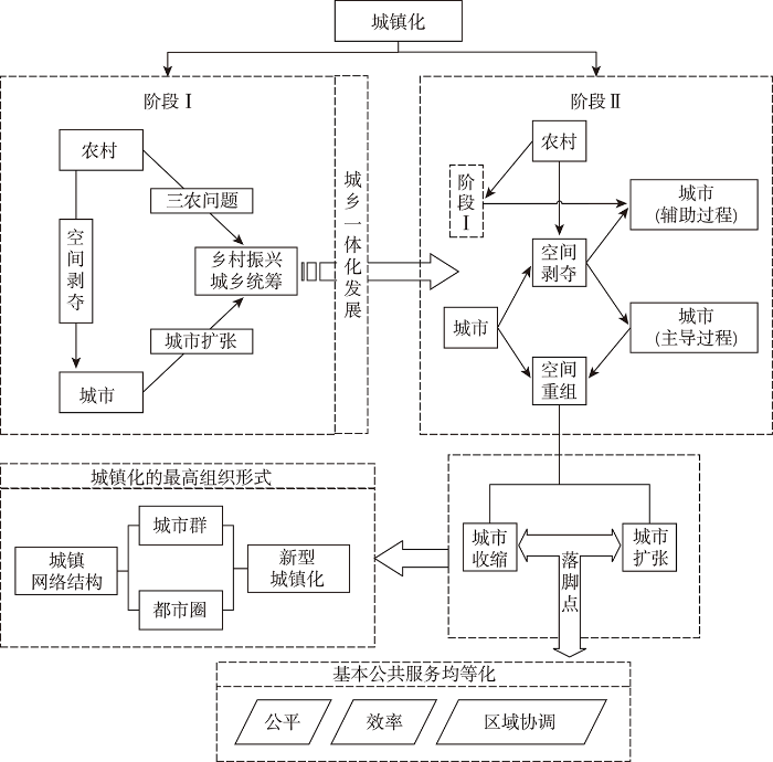
图1
城市收缩、城市增长与城镇化的关系
Fig.1
Relationship between urban shrinkage, urban growth, and urbanization
1.2.2 城市收缩与地方化、全球化的关系认知
城市是立足于区域的一个功能性节点、一个耗散结构体,时刻需要与外界进行物质、能量和信息熵的交换、传递和转化。城市发展(增长或收缩)本质是一个在市场经济条件下城市“区域发展要素集聚能力”的相对上升或下降的结果反馈[28-29]。人力资本、工厂企业、投资等发展要素追求利润最大化而不断由低效率地区向高效率地区转移[30];立足于交通和通信技术,不断创新的经济全球化和区域经济一体化则为降低发展要素流动成本提供了切实可行路径[31]。大量研究表明,全球化、去工业化、后社会主义转型、全球金融危机等是引致城市收缩的全球性因素[25,32-33]。近年来以新自由主义为理论主导的全球化不断推进,国家与区域之间的交流开放之门越敞越大、资源流动的时空距离压缩趋强,市场基于效率最大化原则驱使要素流不断涌向产出禀赋更佳的世界城市、区域性大城市,大城市辐射下的中小城市不免因要素流失而陷入就业结构变化和行业部门调整的收缩困境之中[34];城市经济转型或功能性地域结构转变是区域地方性因子[24,35]。佐证了收缩城市形成与发展实质上是一个根植于本土化而嵌于全球化共同作用的结果:自身“区域发展要素集聚能力”(相对或绝对)不足而导致发展要素被“挤出”是根本性和决定性原因;经济全球化和区域一体化强化了区域关联与竞合,为收缩城市要素外流提供流动方向和路径;二者共同作用导致收缩城市的形成与发展。因此,开展城市收缩研究与收缩城市问题响应应该摆脱“就城市论城市”的片面性,强调区域相互作用与空间关联性,国内以吴康为代表的部分学者开始基于网络视角对此展开了收缩城市形成机理的实证分析[36]。
1.3 城市收缩与收缩城市概念界定与内涵辨析
1.3.1 城市收缩与收缩城市概念辨析
城市收缩概念内涵丰富、涉及范围广、涵盖各种社会经济现象,迄今为止尚没有一套统一的收缩城市界定标准。如收缩城市世界研究网络(SCIRN)认为,“拥有不少于1万以上常住人口、大部分地区经历了超2年的人口外流、且伴随某种结构性经济转型与危机的人口密集城市区域即为收缩城市[37]”;Oswalt等[38]认为,人口流失总量达10%以上或连续3年年均人口流失量均在1%以上的城市即为收缩城市;Martinez-Fernandez等[39]则认为一个城市或地区只要经历过人口流失及由此引发系列城市发展问题即可定义为收缩城市;Hollander等[40]也持类似的观点,认为只要存在人口流失的城市即为收缩城市;多指标变化学则认为收缩城市不仅是人口的流失,更是彰显综合实力的投资、就业水平等的下降[8]。国内收缩城市亦是如此,如国家发展改革委认为城区常住人口连续3年出现持续下降即为收缩城市;张贝贝等[23]认为由于收缩城市的形成机理和社会经济发展背景的区域差异,宜采用差别化的界定标准;孟祥凤等[41]、戚伟等[42]、张明斗等[43]、杨振山等[44]强调收缩城市世界研究网络的界定标准;林雄斌等[45-46]强调收缩城市表征的多维性和成因的多元性。
究其根源,归于2个方面:① 城市收缩和收缩城市概念混淆。类似于区域城镇化与城镇化区域,二者存在实质性区别,其中城市收缩是人力资本、工厂企业、投资等发展要素外流及要素—效应耦合的过程或现象描述,收缩城市是依据判断标准并被确定的类型城市,是收缩问题出现的程度标准化处理和结果的反馈。二者的混淆、等同使用导致收缩城市识别标准制定存在基于现象过程描述(即出现人口流失等现象为收缩城市)与基于程度标准确定(即达到某个“门槛值”标准为收缩城市)的不一。② 概念界定注重现象描述而忽视“要素—经济发展—城市功能”的发展关联。人口流失不是一个孤立现象,与其他发展要素(工厂企业、资金)、经济发展和城市功能等密切关联;而且研究城市收缩的最终落脚点在于收缩城市问题本身(空地、住房空置、财政锐减、居民幸福指数下降等),而非人口外流现象,故此将城市收缩看成是一个现象、过程与问题的有机统一更具现实意义。
综上可见:① 城市收缩是过程函数和状态参量,收缩城市是程度标准和结果反馈,不能将二者简单地等同使用;② 城市收缩反映的是城市建成区在特定时段内人力资本、工厂企业、投资等发展要素所呈现出的缩减现象和缩减幅度,本身是一个综合概念,单纯基于人口流失的识别方法可能存在偏差,而且无法揭示除人口以外其他发展要素的收缩情况以及彼此间的耦合关联性,如同(人口)城镇化率和(综合)城镇化水平,属于数量与质量的区别与差异。
1.3.2 城市收缩与收缩城市概念界定
基于上述分析,本文将城市收缩概念界定为:城市收缩是指某城市(特指城市化地区)在特定的体制机制环境和时段范围内所呈现出的一个以(常住)人口等发展要素外流为主要表征的现象,以及由此引致发展效应耦合的过程与问题的集合,侧重现象、过程与状态(问题)的描述与表征,是一个综合概念;强调与凸显其发展能力受限的基本事实。而收缩城市是指城市收缩(现象与问题)达到设定的标准和门槛值而被划定的类型城市。
1.3.3 城市收缩内涵思辨
(1) 概念界定上,城市收缩内涵设置了对研究对象及其研究范围、研究时段、研究背景和外在表征的基本限定,指出城市收缩是以单个实体城市为研究对象、以其具体的城市化地区为研究范围、纵向考察其在某个设置的时间段内是否呈现出随所处的城市—区域发展环境及其空间相互作用的演化而表征出发展要素外流及其效应耦合的收缩现象与问题,同时通过设定符合区域发展实际情况的“门槛值”来识别与划分收缩城市及其类型。换句话说,城市收缩研究具有“语境”异质性:从研究范围到形成背景与作用机理再到收缩城市识别标准乃至其响应模式具有明显的地域差异性(尤其是国别差异性),开展城市收缩的“本土化”思考显得尤为必要与迫切。
(2) 内在本质上,首先,城市收缩是城市“区域发展要素集聚能力”在区域关联中相对或绝对下降而使以人口为主要表征的发展要素做出“再区位”的一种市场行为[28-29],并引致具有单向性的空间作用效应——区域外部性[26]:对流入城市产生正外部性效应、对收缩城市产生负外部性、发展要素被“空间剥夺”;发展过程具有客观规律性——在市场经济条件下发展要素由低效率城市流向高效率城市[30],实质就是一个市场经济过程[31]。期间可能存在损失区域协调、社会公平公正的市场“失灵”现象,故此具有人工调控的可能性、可行性和必要性。其次,外流的发展要素不仅有高素质人才、青壮年劳动力,还有投资、工厂企业等其他发展要素,引致的耦合效应涉及经济社会发展、公共服务与地方财政税收、资源利用效率等方方面面,故收缩城市的识别需强调多要素、多维度的综合权衡。再者,城市收缩不仅是城市自身的作用,更是区域关联和空间相关作用的结果产物,避开区域、就收缩城市论收缩不科学。
(3) 发展效应具有尺度差异性。从整个国家或宏观区域层面来看,城市收缩就是一个资源优化重组的过程,以人力资本、工厂企业、投资和技术等为代表的发展要素由低效率表征的收缩城市向高效率表征的大城市、中心城市以及城镇化高级组织形态城市群、都市圈流入,无疑是提高了相关发展要素的投入产出效率,也有助于提高城市建设用地效率,中国以城市群、都市圈为核心的新型城镇化国家战略就是最好的效率导向。当然,期间涉及核心价值导向时需要具体问题具体分析,比如边境(口岸)城市、少数民族自治区城市等,关系到国家领土安全、社会公平和生态安全、粮食安全时,不能简单地以资源最优配置来看待与应对收缩城市的尺度效应。其次,从收缩城市本身来看,发展要素和发展机会被“空间剥夺”,而且短时间内这种现象无法实现扭转,无疑是一种发展负外部性。可见,城市收缩是一个比较复杂的社会经济问题和地学问题,需要具体问题具体分析,也由此回归到新型城镇化的本质内涵,响应城市收缩或收缩城市的基本思路在于基本公共服务均等化。
(5) 城市收缩词性之辩。诸多学者将城市收缩看成是城市人口流失过程和现象,所以不带感情色彩[23-24]。但事实上,城市收缩与城市增长相对立,可以从城市增长来理解城市收缩。城市增长是指投资和人口增加引发的城市规模和基础设施、公共产品的增加,包括以城市建设用地增加、土地利用集约度提高为核心的空间增长和以人口与经济发展为核心的非空间增长 (
2 城市收缩内涵的“中国化”思考
结合上述对城市收缩概念的界定及其内涵的思辨,下文拟从研究范围、研究时段、收缩城市识别方法、城市收缩形成背景和作用机理的区域异质性4个方面,开展城市收缩内涵的“中国化”与“本土化”探讨。
2.1 研究范围
城市概念及其行政区划体系组成存在国别差异性,导致城市收缩的研究范围不尽相同。如德国和美国的一级行政单位是州,二级行政单位在德国是城市、在美国是县,城市与镇在美国属于第三级行政单位。故此城市收缩研究范围设定中,德国是包含农村县和乡镇的整个建成区范围,美国是以城市或镇的市辖区为研究范围,而国内已有研究存在2种研究范围的混合使用,并不统一[47],导致如上所述的收缩城市识别结果的巨大差异。中国城市行政区划体系分为省—地级市(直辖市)—县等3个层级,其中直辖市和地级市在财权和事权上相对独立、是一种平行关系,地级市和县之间属于上下级关系、属于垂直型行政区经济等级体,地级市对县社会经济发展要素等具有很强的支配决定地位[48]。中国实体城市的城市化区域主要集中于城市建成区,而且目前正处于城镇化的快速发展阶段,基于基本国情和数据的可获取性与研究的可操作性,以城市建成区为研究范围、划分地级市和县(县级市)2个尺度开展中国语境城市收缩研究更具现实意义。
2.2 研究时段
收缩城市界定时,通常以某个时间段内连续出现3年及以上人口流失或人口流失总规模达-3%的门槛值来划定[38],至于这个时间段为多长,计算时起点时间和终点时间如何选择等,在所有的文献中都缺乏交代,如中国收缩城市的实证分析中,在人口变化学层面,有以基于全国人口普查数据的10年为研究时段,有以基于全国人口普查数据结合全国1%人口抽样调查数据的5年为研究时段,有以基于统计年鉴数据的不等时间为研究时段[41⇓-43,45,49],通过计算[(研究期末年份人口数–研究期初年份人口数)/研究期初年份人口数]的人口规模数变化情况及设定的“门槛值”来识别收缩城市,但研究期末与期初选取的不同,必然带来针对同一对象不同时段收缩城市界定结果的时序差异与同一时段不同对象识别的个体差异,使分析结果的科学性、权威性和现实可操作性遭到了极大的挑战与冲击。
基于现象、过程与问题集合的收缩城市多维度、多指标识别过程中,一方面存在城市收缩过程中发展要素外流并非同时进行,彼此间存在先后顺序、主次关系(到底“谁”引导“谁”流失导致城市收缩)且发展要素的流动处在动态变化中;发展要素外流的发展耦合效应同样具有一定的滞后期,并不一定会立竿见影,如住房空置率、城市空地、城市基本公共服务设施服务水平、地方政府债务等,都是滞后慢慢凸显;另一方面如上所述,因为[(研究期末年份人口数–研究期初年份人口数)/研究期初年份人口数]计算方式中涉及初始年份的选取,即出现城市收缩现象(且连续3年以上)的初始年份的选取直接关系到计算结果的准确性;故此,在收缩城市识别研究中,研究时段的选取不宜过短、也不宜过长:过短难以凸显发展的滞后问题、过长可能会掩盖期间的发展变化情况,结合中国5年国民经济发展规划、5年近期发展规划、20年左右的城市总体规划(但期间通常会有1~2轮的修编),选取10年期为研究时段可能更为现实、更符合中国实际。
2.3 收缩城市识别标准与方法体系
在收缩城市界定标准体系上,因发展语境不同而存有差异性。首先,在城市人口界定上,中国存在户籍制度的制约(虽然当前已经取消了户籍制度,但门槛效应依然十分明显),城市人口大体可以分为2大类:常住人口(全年经常在家或在家居住6个月以上人口,包括流动人口)和户籍人口(公民依《中华人民共和国户口登记条例》已在其经常居住地的公安户籍管理机关登记了常住户口的人),其中常住人口包含了大量的准市民,即农民工(准市民),不能与户籍人口同等程度享受城市发展基础福利,如社保、医保、小孩上学等[50],而西方语境的城市人口不受户籍影响、可以自由流动、平等共享城市发展基础福利,属于真正意义上的“城市人”,这是中国与西方语境相关国家的主要区别之一。
再者,中国的城市发展人口固然是重要的影响因素,但资金的效用更为突出和显著,尤其是在改革开放到当前推行高质量发展之间,人口众多的基本国情意味着单纯的常住人口流失并不能完全代替城镇“区域发展要素集聚能力”水平,因为其可能存在如上所述的城市职能和发展定位转变、城市产业结构转型升级的人口流失;而西方语境的城市发展在后工业化社会恰好相反,人力成本非常昂贵,人口基本代表了城镇“区域发展要素集聚能力”水平,二者之间存在本质性区别。
综上所述,西方语境以“城市人”流失水平来识别收缩城市具有很强的解释力和现实意义,因为其在很大程度上代表了城镇“区域发展要素集聚能力”水平;而国内常住人口不能与之等同,常住人口并非完整意义上的“城市人”,简单挪用西方语境的人口流失标准来识别划分中国语境的收缩城市显然是不合理的。鉴于此,本文探讨性提出城市收缩“现象、过程与问题的有机统一”和基于“发展要素流失及其耦合效应”的多维度、多指标收缩城市识别指标体系和界定标准,并据此构建基于“二步诊断法”的收缩城市识别法:第一步,以人口流失指标确定初步收缩城市;第二步,以综合指标确定最终收缩城市。以综合指标取代单一人口来贴近中国凸显“城市发展能力受限”的基本现实。其中识别指标体系凸显“要素流动”及其耦合效应,具体涉及人力资本(高素质人才、青壮年劳动力、常住人口)、经济社会发展、投资消费、基础公共服务及其地方财政保障、资源利用效率等维度;识别标准及其类型划分标准作者在他文中将其限定如表1所示,具体设定方法,详见参考文献[26]。
表1 城市收缩类型及其划分标准
Tab.1
| 收缩阶段 | 划分标准 |
|---|---|
| 收缩前期 | -3% <Xi <0且Ai ≤ -10% |
| 收缩初期 | -5%<Xi ≤ -3%且-15%< Ai ≤ -10% |
| 收缩中期 | -10%<Xi ≤ -5%且-20%< Ai ≤ -15% |
| 收缩后期 | -20%<Xi ≤ -10%且-30%< Ai ≤ -20% |
| 衰败 | X1≤ -20%且Ai ≤ -30% |
注:表格来源于参考文献[
2.4 形成背景与作用机理的区域异质性
以人口为主要表征的发展要素外流是收缩城市自身发展及其与区域关联共同作用的结果,是一个市场行为,在这个过程中城市所处的体制机制环境决定了市场行为的“市场经济性”和“政府计划性”,进而差别化影响着收缩城市形成与发展的内在作用机理及其作用效应。可以说,其是揭示、预测与规划响应收缩城市形成与发展的关键所在,也是凸显城市收缩研究“本土化”“中国化”最核心的内容之一。中国与西方语境城市收缩所处的发展环境存在很大的差异性,具体体现在以下几个方面:① 在区情上,中国幅员辽阔、区域发展差异显著,意味着中国较西方语境相关国家收缩城市形成与发展的背景更加复杂多元化。② 在体制环境上,其一,中国实行的是具有“中国特色”的社会主义市场经济体制,是政府职能与市场机制的有机结合,强调国家战略安排和地方政府发展规划导向城市发展要素流动及其区域空间关联,如东部沿海率先发展、东北振兴、西部大开发、中部崛起四板块经济布局,基于城市群、都市圈为核心的新型城镇化空间布局,基于长江经济带与“一带一路”构筑双循环发展新格局布局等,都是源于国家政策导向的“政策高地”来实现对发展要素的空间配置、对城市区域空间关系的重构;其二,中国属于中央集权制国家,中央与地方、财权与事权、政府行为绩效考评与官员升迁等,有别于西方语境相关国家,使其城市发展(基础设施建设和城市经济空间布局)带有明显的行政等级性和中心偏向性,引致垂直型行政区经济之间、中心城市与外围城市、发达城市与欠发达城市之间发展要素的空间剥夺与被剥夺;其三,中国属于社会主义国家,强调“人民至上”的发展理念,所以在统筹考虑发展效率的同时,强调社会公平、公正和国家的全面安全观,没有西方语境相关国家所谓的种族歧视、空间分化。③ 在发展环境上,中国当前如上所述,正处于城镇化的快速发展、工业化中后期阶段,而西方语境相关国家基本处于城镇化成熟、工业化后期阶段,去工业化、郊区化等对彼此间城市收缩形成与发展的影响差距显然是十分显著的。
这些独具“中国特色”的区情和体制机制环境,意味着中国收缩城市的空间分布、发展特征及其形成与发展的背景、作用力与影响因素更趋多元化、复杂化与独特性,完全套用西方语境的城市收缩内涵来揭示、剖析与规划响应中国收缩城市显然是不够的。故此,在规划响应上,存在区域性城市收缩与个体城市收缩、边远山区城市收缩、边境地区城市收缩、少数民族地区城市收缩、粮产区城市收缩、生态脆弱地区城市和一般意义上的城市收缩等的类型差异性和区域差异性,而这就是城市收缩内涵“中国化”最真实的写照。
3 中国语境城市收缩研究理论分析框架与地理学实践
3.1 理论分析框架构建
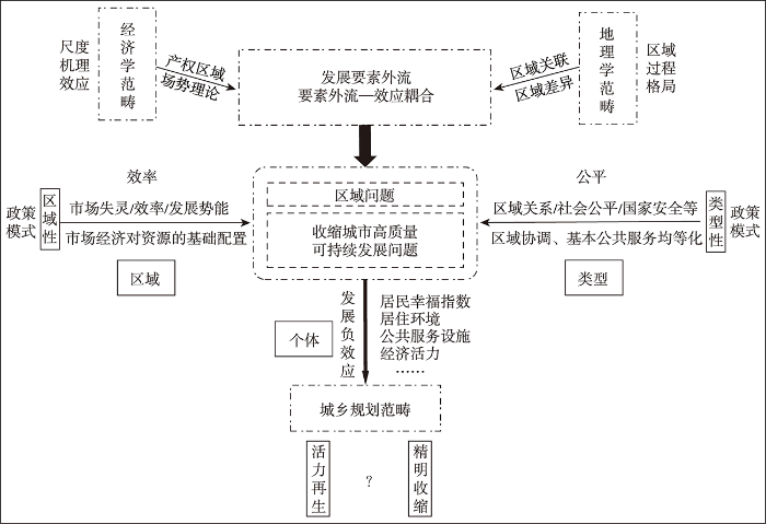
城市收缩内涵及其“中国化”思考透视了以下几个基本观点:其一,收缩过程中,城市以人力资本(高素质人才、青壮年劳动力)、发展资金、工厂企业等为主要表征的相关发展要素出现外流且呈现出城市发展能力受限为基本事实;其二,要素外流是城市自身发展能力及其与关联区域相互作用、区际博弈的结果,属于市场经济行为,期间城市属性及其区域发展环境存在异质性特征,导致其收缩城市发展特征及其空间分布、收缩过程的作用力、作用效应乃至响应模式的(区域、类型、发展阶段等)异质性;其三,城市收缩不仅意味着城市发展能力的受限,更是城市居民幸福指数、社会公平公正、城市运行资金和城市(建设用地、住房等)资源利用效率等提升的“拦路虎”。期间涉及公平与效率、安全与发展、整体与局部、区域与类型的价值取舍与权衡问题,是收缩城市实现高质量可持续发展、制定规划响应和政策举措的核心目标与关键内容所在。可见,城市收缩是一个融合经济学、地理学和城乡规划学的综合性科学问题。
(1) 地理学范畴。制定收缩城市识别标准与方法体系、识别收缩城市并对其进行分组、分区域和分类别比较归纳统计——通过对城镇发展要素外流现象及其发展耦合效应的过程、格局、机理和效应的综合考察,结合地理学区域差异性、系统综合性和区域空间关联性,识别并划分中国收缩城市及其收缩类型、规律,总结源于收缩城市发展要素被“空间剥夺”而形成的不同收缩类型的区域关系问题和收缩城市高质量可持续发展问题。
(2) 经济学范畴。明晰城市收缩的本质及其响应政策的选择:其一,在中国各个城市就是一个个相对独立的“产权区域”,拥有相对独立的财权和事权,通过区际博弈来获取发展所需的“要素流”[51-52],城镇“区域发展要素集聚能力”如同磁场中的场势[53],当其“发展势能”相对或绝对弱化时,城市呈现出收缩状态,发展要素外流;当其“发展势能”相对增强时,城市呈现出增长状态、发展要素流入。“产权区域”理论和“场势理论”是经济学对城市收缩内涵(发展要素流动与发展效应变化)最本质的阐述。其二,收缩城市存在区域性、类型性异质性,需要制定差别化的响应政策,但地理学虽然关注区域问题、长于分析问题,却总是以实际问题为着眼点,往往忽视区域利益主体的存在、欠缺一种主观的价值标准,因此在解决问题的政策空间落实上显得薄弱,而经济学长于抽象与理论演绎,可以实现对不同政策的评判和优选,故此既可以运用经济学成本—效益、投入产出分析手段,实现对中国收缩城市响应政策的分区域、分类型差别化实施,提高其精准性和可操作性。
(3) 城乡规划学范畴。制定收缩城市高质量可持续发展的空间落实路径——针对收缩城市发展中呈现出的经济发展低迷、住房空置率高、地方财政吃紧、城市建成环境萧条、城市空置地多、资源浪费严重等发展问题,从精明收缩或活力再生等视角对具体问题进行规划响应和空间落实(空间结构调整、产业发展、环境整治、公共基础服务设施建设等),期间彰显“以人为本”新型城镇化内涵、落实基本公共服务均等化与区域协调发展是重要前提和调控手段;但城乡规划学总是强调解决城市自身问题的精准性和可操作性,长于“一城一策”“一城一规划”的中微观细节调控,往往忽视收缩问题的区域关联性、缺乏对收缩“共性”的规律性总结。
据此,本文结合经济学相关基础理论、地理学系统思维和城乡规划学落实手段,以经济学“产权区域”理论和“场势理论”作为阐述城市收缩形成与发展的基础理论,以地理学差异性、区域关联性和系统综合性实现对中国语境收缩城市的识别及其分层次、分类别、分区域的规律性总结,以城乡规划学空间规划和经济学抽象演绎手段提出中国语境城市收缩问题的解决之道,形成图2所示的中国语境城市收缩研究理论分析框架。
图2
3.2 中国城市收缩研究地理学实践
遵循地理学经典的“格局—类型—机理—响应调控”的研究范式,本文对中国语境地理学城市收缩研究内容进行了系统梳理,具体情况如下:
3.2.1 构建中国语境收缩城市识别体系与类型标准
主要研究内容安排如下:① 中国语境收缩城市识别的指标体系构建——选用哪些指标、是否有数据支撑及如何获取数据等是关键要点;期间如何运用科技的发展来提升指标的选取范围和数据获取的能力尤为重要,如表征住房空置率、城市空置地指标是反映城市收缩资源利用效率变化的重要指标,但由于中国城市住房不同于西方语境的低层、别墅式住宅,大多属于多层、高层住宅,难以机械化识别;空置地难以量化等,如何基于无人机航怕、夜间灯光数据、遥感解译等实现对这些数据的挖掘与使用。② 中国语境收缩城市识别标准制定——基于综合得分制定合理的收缩城市识别标准,基于国情区情制定划定收缩城市类型划分标准;期间需要考虑是否需要分区域制定收缩城市识别标准,又该如何设置等。
3.2.2 中国收缩城市识别及其发展特征
主要研究内容安排如下:① 开展中国城市收缩研究实证分析,识别并揭示中国收缩城市的空间分布特征;② 分类型、分区域、分尺度、分阶段对中国收缩城市发展特征及其规律性特征进行揭示与归纳统计; ③ 收缩城市及与增长性城市之间的空间关联性特征分析。
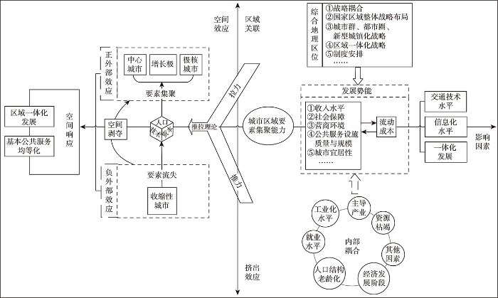
3.2.3 中国收缩城市形成与发展影响因素与作用机理
主要研究内容安排如下:① 构建中国语境收缩城市形成与发展的机理解析框架——基于城市发展及其与关联区域的相互作用,构建适应中国情景的收缩城市形成与发展机理。本文基于推拉理论的空间关联外部发展环境(综合地理区位优势)与区内“挤出”的内部发展效应(区内资源枯竭、去工业化、产业结构单一、主导产业缺乏竞争力等)以及要素流动成本(交通运输条件、户籍制度改革、区域一体化发展)的综合考虑,构建了图3所示的形成机理解析框架。② 结合具体研究区域,运用上述构建的收缩城市形成与发展的机理解析框架,对收缩城市形成与发展的具体影响因素(含国家政策、政府行为等)、作用力和作用机理进行分层次、分区域、分尺度、分阶段、立足典型的实证分析,并据此提炼“共性”规律。
图3
3.2.4 中国收缩城市效应评价与规划响应
主要研究内容安排如下:① 收缩城市效应评价——城市收缩产生了哪些影响,如城市建成区土地利用效率、城乡一体化水平[54]、居民生活质量(幸福指数)的变化等,为什么?② 收缩城市规划响应——基于公平与效率、安全与发展、整体与局部、区域与类型的综合权衡,从精明收缩和活力再生2个维度,制定最适宜收缩城市的响应规划与响应政策举措;期间包括对具体精明收缩规划手段、活力再生创新思路等的创新探索。
3.2.5 中国收缩城市发展预测
主要研究内容安排如下:顺应国情国策预判中国收缩城市未来可能出现的空间分布、主要发展类型演变等,如“一带一路”、双循环新发展格局、人口老龄化、生态文明建设、去工业化、制造业转型升级与区域转移等,是否会对全国城市发展与收缩产生影响,产生什么影响,又该如何去应对等,也是未来落实城市收缩中国本土化研究的主要内容。
4 结论与讨论
4.1 主要结论
城市收缩是一个嵌入全球化而根植于本土化的结果,存在形成背景和作用机理的区域异质性,如何认知与构建中国语境收缩城市内涵及其研究框架已成为当前国内城市收缩研究中拟优先解决的关键性科学问题,本文对此展开了初步探索,主要观点与结论如下:
(1) 城市收缩是区域城镇化发展的阶段性产物,与城市增长构成一对方向互异且动态转化、映射区域城镇化空间效应的函数关系式;亦是一个嵌入全球化而根植于本土化的结果产物,强调城市收缩研究的区域关联性和本底约束性。
(2) 当前收缩城市识别标准的不统一,主要归因于城市收缩与收缩城市概念混淆、收缩概念偏重现象描述而忽视要素—功能发展关联;本文提出城市收缩是现象过程与状态的描述,收缩城市是对问题出现的程度标准化和结果的反馈;并据此提倡将收缩城市看成是一个现象、过程与问题的集合,强调与凸显城市发展要素外流与城市发展能力受限的基本事实;同时指出城市收缩具有发展的尺度效应、整体的不可逆性和个体的可塑性。
(3) 结合城市收缩内涵,从研究范围、研究时段、收缩城市识别方法、城市收缩形成背景和作用机理的区域异质性4个方面,对其“中国化”进行了探讨,提出以城市建成区为研究范围、以10年为考察期、以综合取代单一人口指标来彰显中国“城市发展能力受限”的发展现实构建收缩城市识别标准与方法体系,立足城市及其关联区域整体发展环境,剖析、预测与响应收缩城市的形成与发展等内容与形式来落实其内涵的“中国化”。
(4) 城市收缩是一个多学科交融的综合性概念,涉及发展要素空间流动及其再区位的市场经济行为、城市和区域相互作用与空间关联的地理作用以及基于语境关联的规划响应等。鉴于此,本文以经济学“产权区域”理论和“场势理论”作为阐述城市收缩形成与发展的基础理论,以地理学差异性、区域关联性和系统综合性构建中国语境收缩城市的识别标准体系,以城乡规划学空间规划和经济学抽象演绎手段探索不同发展语境下收缩城市的响应模式与路径,尝试构建城市收缩中国研究的理论框架和内容构成。
4.2 讨论
本文基于科学隐喻和逻辑思辨对城市收缩内涵及其“中国化”进行了初步探讨,并形成了一些可供参考的基本结论,但是否完全适应中国国情,尚需进一步的实践检验;其次,城市收缩研究“中国化”可为世界城市收缩研究提供“中国经验”,但如何实现不同国家收缩城市的横向比较研究、实现世界收缩城市的一体化研究存在诸多障碍;再者,土地闲置和住房空置等是收缩城市面临的最核心问题,但目前由于技术、方法和数据难以获取的局限,难以准确计算与科学划定闲置(或空置)的比例、质量及其空间分布,下一步如何研创、开发新技术来获取新数据、支撑研究,将是今后研究中较长一段时间内拟重点聚焦和解决的关键性科学问题;最后,传统基于“增长情景模拟”的规划范式已经不再适用于收缩城市,如何实现城市收缩与当前国土空间规划的合理衔接,亦是今后有待深入探讨的核心科学问题。
致谢
非常感谢审稿专家从概念内涵、行文用语、逻辑框架等方面提出诸多的宝贵修改意见,受益匪浅。
参考文献
A meta-analysis of shrinking cities in Europe and Japan: Towards an integrative research agenda
[J].DOI:10.1080/09654313.2019.1604635 URL [本文引用: 1]
Shrinking cities: Urban challenges of globalization
[J].Urban shrinkage is not a new phenomenon. It has been documented in a large literature analyzing the social and economic issues that have led to population flight, resulting, in the worse cases, in the eventual abandonment of blocks of housing and neighbourhoods. Analysis of urban shrinkage should take into account the new realization that this phenomenon is now global and multidimensional — but also little understood in all its manifestations. Thus, as the world's population increasingly becomes urban, orthodox views of urban decline need redefinition. The symposium includes articles from 10 urban analysts working on 30 cities around the globe. These analysts belong to the Shrinking Cities International Research Network (SCIRN), whose collaborative work aims to understand different types of city shrinkage and the role that different approaches, policies and strategies have played in the regeneration of these cities. In this way the symposium will inform both a rich diversity of analytical perspectives and country-based studies of the challenges faced by shrinking cities. It will also disseminate SCIRN's research results from the last 3 years.
中国收缩城市及其发展的负外部性
[J].
DOI:10.13249/j.cnki.sgs.2019.01.006
[本文引用: 2]

以中国地级市为研究对象,选取2003年和2014年2个时点,通过分析各地级市市辖区、非市辖区的人口变化及二者相对变化情况判断收缩及潜在收缩城市;基于城市发展的负外部性内涵,构建涵盖房地产、环境、交通、教育、医疗及就业等方面指标的评价体系,运用主成分分析法测度收缩及潜在收缩城市发展的负外部性,并分析其变化方向。研究结果表明:① 中国的城市发展仍然以增长为主,收缩城市及潜在收缩城市比例并不高,收缩城市主要分布于东北三省及西北地区,潜在收缩城市则集中分布于河南、湖南等中部人口大省及广西、贵州等省、自治区;② 收缩城市发展过程中其负外部性显著改善,尤其是处于稳定收缩阶段的绝对收缩城市最为明显,辐射式收缩城市次之,而处于收缩初始阶段的郊区化收缩城市则表现出两极分化特征;③ 大部分潜在收缩城市其负外部性有不同程度的加剧,且负外部性加剧的城市主要以湖南、河南的潜在收缩城市为主。
Change in the negative externality of the shrinking cities in China
DOI:10.13249/j.cnki.sgs.2019.01.006
[本文引用: 2]
Along with the aging and migration of population, deindustrialization and economic crises, the beginning of 21th Century there has witnessed a phenomenon of urban shrinkage across China, which is quite common for industrial and resource-based cities. The shrinkage caused a negative impact on social, environment and economic aspects so that it has gradually been a concerned topic for the future development of Chinese cities. As one of the major challenges that China are faced during the process of new-type urbanization, rather than highlighting urban growth, the smart urban shrinkage could be a possible way for shrinking cities to step into a sustainable way. The purpose of this article is to measure the urban negative externality and evaluate the impact of shrinkage on the change of such externality. With the usage of population data of all prefecture-level cities(Hong Kong, Macau and Taiwan are excluded) in 2003 and 2014, this article identified the types of urban shrinkage through analyzing the population changes of municipal district and non-municipal district separately, as well as their difference during this period. Furthermore, a comprehensive index system has been built up to measure the negative externality of all prefecture-level cities. The index system includes aspects of estate price, urban environment, transportation, education, health and employment. By applying the method of principal component analysis (PCA), a synthesis score was calculated, followed by revealing the change direction of urban externality for each type of shrinking and potential shrinking cities. The results of the study are listed as follows: 1) urban development across China is still centered on urban growth, and the shrinkage and potential shrinkage are not very popular. Shrinking cities are mainly distributed in Northeast China (i.e. Heilongjiang, Jilin and Liaoning) and part of Northwest China (i.e. the south of Gansu). However, potential shrinking cities tend to gather in Central China, including Henan and Hunan (two populous provinces), as well as in some inland provinces (i.e. Guangxi and Guizhou); 2) the urban negative externality of shrinking cities will exacerbate as their population increase, and the type of sheer shrinking cities is most remarkably reflected, followed by the type of dispersive ones. But in terms of suburbanized shrinking cities, the change of urban negative externality shows a bi-directional characteristic, namely the externality of part of these cities increase while others decrease equally in number; 3) an exacerbated urban negative externality with different degrees occurs on most potential shrinking cities, and they are mainly located in Hunan and Henan, two provinces in Central China. As for the urban shrinkage, which is not widespread across the whole country, the government should pay much attention on shrinking and potential shrinking cities. Implementing efficient and appropriate policies (i.e. economic restructuring, industrial upgrading, innovation encouragement) is imperative to make the shrinkage to be smart and maximize urban utility during the shrinking process.
Plan implementation challenges in a shrinking city
[J].DOI:10.1080/01944363.2019.1637769 URL [本文引用: 1]
Die schrumpfende stadt und die stadtsoziologie
[M]//Friedrichs J. Soziologische stadtforschung: Kölner Zietschrift für Soziologie und Sozialpsychologie. Wiesbaden, Germany: VS Verlag für Sozialwissenschaften,
Conceptualizing urban shrinkage
[J].DOI:10.1068/a46269 URL [本文引用: 1]
Historical trajectories of currently shrinking Portuguese cities: A typology of urban shrinkage
[J].DOI:10.1016/j.cities.2015.11.008 URL [本文引用: 1]
The shrinking city in comparative perspective: Contrasting dynamics and responses to urban shrinkage
[J].DOI:10.1016/j.cities.2016.09.008 URL [本文引用: 2]
Multi-criteria assessment of socio-environmental aspects in shrinking cities: Experiences from Eastern Germany
[J].DOI:10.1016/j.eiar.2007.09.004 URL [本文引用: 1]
Urban shrinkage in Germany and the USA: A comparison of transformation patterns and local strategies
[J].Many American and European cities have to deal with demographic and economic trajectories leading to urban shrinkage. According to official data, 13% of urban regions in the US and 54% of those in the EU have lost population in recent years. However, the extent and spatial distribution of declining populations differ significantly between Europe and the US. In Germany, the situation is driven by falling birth rates and the effects of German reunification. In the US, shrinkage is basically related to long-term industrial transformation. But the challenges of shrinking cities seldom appeared on the agendas of politicians and urban planners until recently. This article provides a critical overview of the development paths and local strategies of four shrinking cities: Schwedt and Dresden in eastern Germany; Youngstown and Pittsburgh in the US. A typology of urban growth and shrinkage, from economic and demographic perspectives, enables four types of city to be differentiated and the differences between the US and eastern Germany to be discussed. The article suggests that a new transatlantic debate on policy and planning strategies for restructuring shrinking cities is needed to overcome the dominant growth orientation that in most cases intensifies the negative consequences of shrinkage.
Schrumpfende Städte in Westeuropa: Fallstudien aus Frankreich und Grossbritannien
[J].
The development of urban shrinkage discourse and policy response in Japan
[J].DOI:10.1016/j.cities.2017.02.011 URL [本文引用: 1]
Shrinking cities, volume 1: International research
[M].
Spatial metrics to study urban patterns in growing and shrinking cities
[J].DOI:10.1080/02723638.2015.1096118 URL [本文引用: 1]
How does (n't) urban shrinkage get onto the agenda? Experiences from Leipzig, Liverpool, Genoa and Bytom
[J].DOI:10.1111/1468-2427.12101 URL [本文引用: 1]
Policy responses to urban shrinkage: From growth thinking to civic engagement
[J].DOI:10.1080/09654313.2013.793655 URL [本文引用: 1]
Strategic spatial planning and the longer range
[J].
Shrinking cities in growing China: Did high speed rail further aggravate urban shrinkage?
[J].DOI:10.1016/j.cities.2018.09.017 URL [本文引用: 1]
中国收缩城市及其研究框架
[J].
Shrinking cities in China
珠三角快速城镇化地区发展的增长与收缩新现象
[J].
DOI:10.11821/dlxb201710006
[本文引用: 1]
珠江三角洲是世界范围内经济和城镇发展“增长奇迹”的典型地区,当中以东莞为代表的“外向型城镇化”模式长期受到国内外学者的关注。然而,2008年的金融危机冲击对东莞经济造成巨大冲击,市域范围同时出现了普遍增长与局部收缩两种截然不同的新空间现象。随着中国经济步入新常态,城镇化快速发展过程中伴随的局部收缩现象逐渐引起学界和社会的广泛讨论。基于此,从城镇发展要素的集聚与流动出发,结合经济、人口和用地三个维度,提出理解城镇增长与收缩的分析框架,并对不同类型特征的城镇进行区分:持续增长、转型增长、潜在收缩与显著收缩。在实证分析部分,文章以东莞为案例,通过考察各镇街单元城镇增长与收缩的时间演变和空间格局,结合典型城镇案例分析,从经济危机冲击、刘易斯转折点、路径依赖存在、制度环境安排四个方面探讨东莞城镇增长与收缩的形成机制,最后对增长与收缩的未来深化研究方向进行讨论。
Growth or shrinkage: New phenomena of regional development in the rapidly-urbanising Pearl River Delta
DOI:10.11821/dlxb201710006
[本文引用: 1]
The Pearl River Delta (PRD), a typical area of rapid urbanization with Dongguan as its most representative case of the 'exo-urbanization' model, has thus long been attracting scholarly attention. However, after the financial crisis in 2008, a new spatial phenomenon has emerged in Dongguan, with overall growth and partial shrinkage taking place in the same city area. As the Chinese economy steps into a state of New Normal, partial shrinkage during a process of rapid urbanization has kindled heated debate. Starting from the vacancy phenomenon caused by the outflow of development factors, this paper has integrated three analytical dimensions, i.e., economy, population, and land, to put forward a framework for understanding urban growth and shrinkage. Four types of towns have been identified in Dongguan, featuring, respectively, continuous growth, resurgent growth, moderate shrinkage, and continuous shrinkage. Moreover, time trajectory and spatial pattern of growing and shrinking have been investigated to account for the distribution characteristic of urban growth and shrinkage. Then, through probing the shocks of economic crisis, Lewisian turning point, path dependence existence and institutional arrangement, we have analyzed the mechanisms of urban growth and shrinkage amid rapid urbanization in Dongguan. Conclusions and avenues for future research are discussed in the last section.
城市收缩的国际研究与中国本土化探索
[J].
International research and China's exploration of urban shrinking
收缩城市研究综述
[J].
A review of researches on shrinking cities
“收缩城市”研究的国际进展与启示
[J].
Shrinking cities: International progresses and implications for China
发达国家城市收缩现象及其对中国的启示
[J].
Urban shrinkage in developed countries and its implications for China
城市收缩的研究进展与展望
[J].
Progress in urban shrinkage research
中国东北三省城市收缩的识别及其类型划分
[J].
DOI:10.11821/dlxb202106004
[本文引用: 5]
城市收缩是一个受经济全球化影响,并具有区域地方特征的世界性经济社会现象,如何构建快速城镇化进程中“中国化”城市收缩研究理论分析框架,为世界城市收缩研究提供中国经验,是新时期中国地理学者、城市规划工作者亟需重点关注和研究的新命题。本文认为城市收缩本质是城市“发展势能”的相对弱化或绝对退化而引起以人口为核心的经济发展要素的再区位和城市功能形态空间重构的响应过程或状态,其是一个综合概念,一个基于人口变化、经济变化、投资消费变化与财政变化等的多维一体过程,据此构建基于“二步诊断法”的城市收缩识别体系及其类型划分标准,同时针对中国最具典型和代表性的东北三省开展城市收缩的实证分析。结果表明:① 东北三省存在明显的城市收缩现象、且呈现出区域化的发展演化趋势;整体可归纳为资源依赖型收缩城市、“虹吸”型收缩城市、综合型收缩城市及区位制约型收缩城市4种模式,其中资源依赖型收缩城市是主体,占据了整个收缩城市的2/3;② 空间上整体呈现出北高南低的空间格局,与经济发展重心不断南移相呼应;③ 指标维度收缩整体遵循“投资消费与经济下行→人口收缩→财政收缩”的内在演化逻辑关联;④ 立足于“二步诊断法”的城市收缩识别体系及其类型划分标准反映出当前基于人口变化学的识别标准的合理性及其局限性——人口变化学能够在很大程度上识别收缩城市,但是对于划分收缩城市类型、揭示收缩城市内在耦合机理具有一定的局限性;⑤ 实证结果表明“二步诊断法”是合理可行的,其可为中国城市收缩的识别、东北振兴政策的制定提供工具支撑与参考依据。
Identification and stage division of urban shrinkage in the three provinces of Northeast China
DOI:10.11821/dlxb202106004
[本文引用: 5]
Urban shrinkage is a global socio-economic phenomenon embedded in wave of economic globalization and rooted in "localization". And it has become a new proposition for Chinese geographers and urban planners to build a theoretical analysis framework of "Chinese-style" urban shrinkage research in the process of rapid urbanization and to provide Chinese experience for the study of urban shrinkage globally. In this paper, we think the essence of urban shrinkage is a response progress or status that the city's "development potential" is relative weakening or absolute degradation and caused re-location of the population-centric economic development elements and spatial reconstruction of the urban functional forms. It is a comprehensive concept, a multi-dimensional and integrated process based on the changes in population, economy, investment and consumption, and social security. And we establish the identification system and the classification criteria of urban shrinkage types based on the "two-step diagnosis method", and select the three provinces of Northeast China which are the most representative urban shrinkage regions in China to make an empirical analysis. The results show that: (1) There does exist an obvious urban shrinkage phenomenon, and the evolution trend is going to regionalization in the three provinces. And we classify the whole identified shrinkage cities into four categories: resource-dependent shrinking cities, "siphon" shrinking cities, comprehensive shrinking cities and location-constrained shrinking cities. It can be found that the resource-dependent shrinking cities are the main body, occupying 2/3 of the entire shrinking cities. (2) The spatial pattern formed by the identified shrinkage cities shows the characteristics that the number of the shrinkage cities is large in the north and small in the south, which is echoing the situation that the economic center is continuously moving from north to south. (3) From the indicator dimension, it can be found that urban shrinking wholly follows the internal evolutionary and logical connection of "investment and consumption, economic shrinkage→population shrinkage→social security shrinkage". (4) The urban shrinkage identification system and its type classification criteria based on the "two-step diagnostic method" in this paper reflect the rationality and limitations of the current urban shrinkage identification standard based on population shrinkage, although it can identify shrinking cities to a large extent, and have certain limitations in classifying shrinking city types and revealing the internal coupling mechanism of shrinking cities. (5) The empirical results confirm that the "two-step diagnosis method" of urban shrinkage is reasonable and feasible, which can provide tool support and reference basis for the identification of China's urban shrinkage and the formulation of policies for the revitalization of Northeast China.
城市化的国际研究
[J].
Urbanization studies: An international approach
近年来新疆城镇空间集聚变化研究
[J].
A study on urban spatial agglomeration in Xinjiang in recent years
东北地区域发展的非均衡性与空间极化研究
[J].
DOI:10.11820/dlkxjz.2011.06.009
[本文引用: 2]
基于对空间极化概念界定的基础上,首先从要素流的视角构建区域发展衡量指标——城镇集聚能力,并从整体上评价1995-2008 年东北三省区域发展演变格局;其次利用差异指数和极化指数,从不同集聚层次对东北三省区域发展非均衡性和极化程度进行测度。研究发现:①从区域发展衡量指标的动态演变格局来看:1995-2008年间东北三省区域发展是一个波浪起伏的过程,整体水平稍有下降;集聚能力得分排序及其演变趋势表明,中心城市、交通枢纽城市和资源城市主宰着东北三省区域发展格局的演变;四中心城市呈现出由北往南递增的发展趋势,且由四城市形成的经济区实体功能开始显化,并沿哈大铁路形成一条不连续的“极化轴”,区域发展中心逐步南移;区域发展的地域差异性非常明显。②从区域发展的非均衡性和极化指数来看:整体上呈增长趋势,其中市区极化程度明显高于县(县级市),且发展演进方向互异;空间分布上非均衡性指数表现出辽宁省>黑龙江省>吉林省,而崔-王指数为黑龙江省>辽宁省>吉林省;城市类型(资源城市与非资源城市)表现出异向发展趋势,其中资源城市呈绝对的下降趋势,且资源城市的极化程度明显低于非资源城市。
Regional spatial polarization in the three provinces of Northeast China based on the ability of urban agglomeration
DOI:10.11820/dlkxjz.2011.06.009
[本文引用: 2]
Based on the concept of spatial polarization, this paper built up a regional development index from the perspective of element flows, which is called urban agglomeration ability, and analyzed the regional development evolution in the three provinces of Northeast China from 1995 to 2008 on the whole. Secondly, the paper used the difference indexes and polarization indexes to measure the degrees of inequality and polarization of the regional development in Northeast China for different concentration levels. The results show that: (1) from the viewpoint of the dynamic evolution of the patterns of regional development, from 1995 to 2008, the regional development of Northeast China had an undulating course, and the overall level was slightly decreased. The agglomeration ability and its evolution trend showed that the center cities, the traffic hub cities and the resource cities played an important role in the regional development pattern evolution. It was showed that the four cities showed that the development trend was increased from north to south. The formed city economic zones began to present their functions, and the Harbin-Dalian Railway became a discrete"polarization axis". The regional development center was gradually moved to the south with the differences of the regional development. (2) The whole region showed a growing trend, in which the municipal administrative areas had a higher degree of polarization than the county level subdivisions, with different directions of evolution. The spatial distribution of inequality index had a sequence of Liaoning Province > Heilongjiang Province > Jilin Province, and the TW index showed a sequence of Heilongjiang > Liaoning > Jilin. The resources cities had an absolute decline, and had a lower polarization degree than the non-resources cities.
长江经济带城市群要素集聚能力差异的比较研究
[J].
DOI:10.18306/dlkxjz.2020.04.002
[本文引用: 2]
城市群作为当前区域发展的主要空间载体,在区域发展竞争中扮演着越来越重要的角色。论文结合互联网大数据抓取等手段,以长江经济带5个城市群为研究对象,对城市群间要素集聚能力差异进行比较研究,发现:① 长江经济带城市群间要素集聚能力差异与长江经济带社会经济发展的区域差异相吻合,城市群要素集聚格局呈现出由东向西梯度衰减的分布特征;② 城际层面要素集聚能力差异的两极分化现象显著,以城市群首位城市为中心的要素集聚“核心—边缘”空间结构特征较为鲜明;③ 长江经济带城市群内科技创新、对外开放、金融等要素的集聚格局具有明显的差异分化和集聚分布指向特征;④ 长江经济带城市(群)要素集聚能力等级规模结构分布总体符合位序-规模法则,可分为“均衡型”和“离散型”2种类型,首位城市要素集聚首位度随城市群要素集聚能力高低呈现出“两端高、中间低”的特征。
A comparative study on the differences of factors aggregating ability among urban agglomerations in the Yangtze River Economic Belt
DOI:10.18306/dlkxjz.2020.04.002
[本文引用: 2]
As the main spatial carrier of regional development, urban agglomerations play an increasingly important role in regional development competition. This study took five urban agglomerations in the Yangtze River Economic Belt as the research object and used the Internet big data and other means to analyze their differences of factors aggregating ability and spatial patterns of factors aggregation. The main conclusions are as follows: 1) The difference in the factors aggregating ability between urban agglomerations in the Yangtze River Economic Belt is very significant. This difference is consistent with the regional differences in the level of social and economic developments within the Yangtze River Economic Belt. The agglomeration pattern of factors is characterized by a gradient from east to west. 2) The difference in factors aggregating ability between cities shows the characteristics of polarization, and the core-periphery spatial structure of factors agglomeration of the urban agglomerations is distinct. 3) In the Yangtze River Economic Belt the spatial agglomeration patterns of factors such as technological innovation, opening up, and finance show clear differentiation and centralized distribution features. 4) The rank-size structure distribution of factors aggregating ability of the five urban agglomerations in the Yangtze River Economic Belt is in line with the Zipf's law, and can be divided into two types: balanced and discrete. The relationship between the primacy ratio of urban agglomeration and factors aggregating ability of urban agglomerations presents a relationship of "high at both ends and low in the middle".
多重城市网络空间结构及影响因素: 基于有向多值关系视角
[J].
DOI:10.18306/dlkxjz.2018.09.008
[本文引用: 2]
从有向多值关系视角,以中原城市群为案例区,对比分析静态网络、百度信息网络、综合交通网络的空间结构,选择经济、文化、行政、时间距离方面的7个因素构建关系回归模型,剖析3个网络的影响因素。结果表明:①3个网络之间的相关系数表现为:百度信息网络与综合交通网络>百度信息网络与静态网络>综合交通网络与静态网络且其值均高于0.582,表明整体的相似性大于差异性;②在空间结构上,3个网络均表现出以郑州为中心,以京广线和陇海线为发展轴,郑州、开封、新乡、洛阳、许昌构成了骨干网络,并形成辐射与集聚优势共存的中心片区;在中心片区之外,3个网络表现出明显的差异性特征。网络节点的辐射与集聚能力在百度信息与综合交通网络中均是正相关,而在静态网络中则是负相关;③关系回归模型的7个因素均对3个网络产生了不同程度的影响,其中企业合作、行业结构相似、经济制度邻近是影响3个网络相似性较强的因素,而收入差距、文化相似、行政隶属、平均时间距离是影响它们之间差异性的因素。本研究为关系转向下的城市体系研究提供了新的思路。
Spatial structures and influencing factors of multiple urban networks based on the perspective of directed-multivalued relation
DOI:10.18306/dlkxjz.2018.09.008
[本文引用: 2]
Urban system is one of the core subjects of human-economic geography. From the perspective of directed-multivalued relation, taking the Zhongyuan urban agglomeration as the case study area, a comparative study on spatial structures and influencing factors of multiple urban networks—static network, Baidu information network, and comprehensive transportation network—will provide a new train of thought for urban system research under relational transition. This study analyzed the hierarchical structure and the node structure of the networks of the Zhongyuan urban agglomeration, to extract generality and particularity of the three networks mentioned above. Furthermore, we built a relational regression model with the help of the quadratic assignment procedure (QAP) method to dissect the influencing factors of these three networks, from the aspects of economy, culture, administration, and time distance. The empirical results are as follows: (1) The correlation coefficients of the three networks are over 0.582, presented as Baidu information versus comprehensive transportation > Baidu information versus static > Comprehensive transportation versus static, and the overall similarity is stronger than the difference. (2) Integrating the three networks, the Zhongyuan urban agglomeration, a mononuclear spatial structure cored by Zhengzhou, consisted of two regional development belts along with the Beijing-Guangzhou railway and the Lianyungang-Lanzhou railway, and formed a central area with obvious advantages of radiation and concentration with a backbone network constituted by Zhengzhou, Kaifeng, Xinxiang, Luoyang, and Xuchang. Outside of the central area, the three networks showed obvious particularity. The radiation and agglomeration ability of cities have negative correlation in static network, while showed positive correlation in Baidu information network and comprehensive transportation network. (3) The seven influencing factors have different effects on the three networks. Enterprise cooperation, industrial structure similarity, and economic system proximity lead to the similarity of the three networks. Meanwhile, income gap, cultural similarity, administrative affiliation, and average time distance lead to their differences.
Hot, congested, crowded and diverse: Emerging research agendas in planning
[J].DOI:10.1016/j.progress.2009.03.001 URL
Demographic change and local development: Shrinkage, regeneration and social dynamics
[M].
Contemporary challenges in planning for shrinkage of historic places: A review
[J].DOI:10.2478/aup-2018-0018 URL [本文引用: 1]
Why do cities shrink?
[J].DOI:10.1080/09654313.2011.593333 URL [本文引用: 1]
Exploring the association between shrinking cities and the loss of external investment: An intercity network analysis
[J].
Planning shrinking cities
[J].
Atlas of shrinking cities
[M].
Shrinking cities in Australia, Japan, Europe and the USA: From a global process to local policy responses
[J].DOI:10.1016/j.progress.2014.10.001 URL [本文引用: 1]
The bounds of smart decline: A foundational theory for planning shrinking cities
[J].DOI:10.1080/10511482.2011.585164 URL [本文引用: 1]
基于百度慧眼的中国收缩城市分类研究
[J].
DOI:10.11821/dlxb202110010
[本文引用: 2]
收缩城市是快速城市化过程中不可忽视的一类城市,按照城市人口变化格局,开展收缩城市分类研究,是发现城市人口“空洞”及变化特征的重要一环。国际上将收缩城市主要分为穿孔型、圈饼型和边缘型,中国的收缩城市究竟包括哪些类型?尚缺少研究证实。本文以中国实体城市为分析单位,利用百度慧眼2016年11月─2018年11月200 m格网的常住人口数据,发现常住人口减少的实体城市共1506座,占实体城市总量(3022座)的49.8%。选取人口较为密集且在研究时段内出现严重收缩现象的126座收缩城市为研究样本,探讨中国收缩城市分类问题。分析表明:126座收缩城市样本多分布在秦岭淮河一线以北地区,包括穿孔型、全局型、局部型、圈饼型、边缘型等5种类型。其中,穿孔型收缩城市最多,共47座(37.3%),为中国收缩城市的主导类型,主要分布于黑龙江、内蒙古、甘肃;全局型收缩城市有33座(26.2%),主要分布于甘肃、陕西;局部型收缩城市有25座(19.8%),主要分布在黑龙江、内蒙古;圈饼型收缩城市有18座(14.3%),主要分布在内蒙古;边缘型收缩城市有3座。“重速度、轻质量”的前半程城镇化,以“增长”为主导的城市规划执念,资源枯竭或经济转型导致传统工业企业衰落解体,政府主动调整下的产业转移等是产生穿孔型收缩城市的主因。研究为政府精细调整城市发展重心、优化土地利用结构、提高城市宜居性、开展收缩语境下的城市规划与设计,提供了科学依据。
Classification of shrinking cities in China using Baidu big data
DOI:10.11821/dlxb202110010
[本文引用: 2]
In the context of rapid urbanization, shrinking cities cannot be ignored. The classification of shrinking cities according to the patterns of urban population changes is the key to reveal the "hollow" and changing characteristics of the population. Researchers classified the shrinking cities in Western developed countries as "perforated", "doughnut" and "peripheral" types. However, there is a lack of evidence showing the types of shrinking cities in China. This paper takes the redefined physical cities in China (excluding Hong Kong, Macao and Taiwan) as the study area, and employs Baidu Huiyan's 200 m × 200 m grid cell permanent population data from November 2016 to November 2018 to identify different types of shrinking cities in the country. Our results show that 1506 physical cities have experienced a population reduction between 2016 and 2018, accounting for 49.8% of the total number of physical cities (3022). Furthermore, in order to accurately identify the types of shrinking cities, 126 densely populated and severely shrinking cities during the study period were selected as the research samples, mainly located to north of the Qinling Mountains and Huaihe River of China. Our analysis shows that the shrinking types of the sample cities can be classified into five categories: "perforated", "complete", "local", "doughnut", and "peripheral". The number of cities with perforated shrinkage is the largest, which numbered 47 (37.3% of the sample cities), most of which are found in Heilongjiang Province, Inner Mongolia Autonomous Region and Gansu Province. Complete shrinkage ranks the second, including 33 cities, which accounts for 26.2% of the samples, and mainly distributed in Gansu and Shaanxi provinces. The numbers of shrinking cities with local, doughnut and peripheral types are 25, 18 and 3, respectively. These cities are mainly distributed in Heilongjiang and Inner Mongolia. This is because the governments paid more attention to the development speed over quality during the first half of China's urbanization process, and adopted a growth-oriented urban planning strategy. Traditional industries declined due to resource depletion or economic transformation, and the transfer of industries under active government adjustment, all of which contribute to the emergence of perforated shrinkage. This study could provide scientific evidence for micro management of urban development, optimization of land use pattern, improvement of urban livability, and conduct of urban planning and design in the context of urban shrinkage.
东北三省人口流失的测算及演化格局研究
[J].
DOI:10.13249/j.cnki.sgs.2017.12.002
[本文引用: 2]
东北三省养育了全国8%的人口,但是改革开放以来人口不断外迁和流出,东北三省人口流失问题受到广泛关注。基于2000年以来的人口普查和抽样统计资料,系统地测算东北三省人口流失量,从省级和县市2个空间尺度分析东北三省人口流失的演化格局。主要结论包括:① 2000~2015年,东北三省人口出现持续流失,并且不断加剧。② 东北三省并不是中国人口流失最严重的地区。③ 东北三省内部出现较多人口流失的县市,空间范围呈现扩张。④ 经济动能不足是东北三省人口流失的主要原因。⑤ 东北三省人口发展的真正问题不在数量,而在人口质量和结构,包括人才流失严重、人口老龄化加剧、人口空间结构高度极化等。
Calculation and spatial evolution of population loss in Northeast China
DOI:10.13249/j.cnki.sgs.2017.12.002
[本文引用: 2]
Northeast China (Liaoning, Jilin and Heilongjiang) occupies 8% of total population in China. However, since the opening up and reforming, frequent population out-migration was on-going in Northeast China. The topic about population loss in Northeast China attracts more and more attentions. According to the census and sampling data after 2000, this research calculates the loss population in Northeast China. Based on the provincial scale and county-level scale data, the spatial pattern evolution of population loss is also figured out. The results are as follows. 1) Northeast China faced a continuous population loss during 2000-2015. And population loss in recent years has aggravated. 2) Northeast China is not the most serious population-losing region in China. 3) Most of counties or cities faced population loss in Northeast China. And population loss area in Northeast China was expanding. 4) The inactive economy development was the key affecting factor for the population loss in Northeast China. 5) The key issues that caused by population loss in Northeast China were population quality and demographic structure, such as brain drain, population aging, and population spatial polarization.This research aims to give some policy implications to the new round development in Northeast China.
东北地区城市收缩的空间格局特征与作用机理
[J].
Spatial pattern characteristics and mechanism of urban contraction in Northeast China
City shrinkage in China: Scalar processes of urban and Hukou population losses
[J].DOI:10.1080/00343404.2017.1335865 URL [本文引用: 1]
我国城市收缩测度与影响因素分析: 基于人口与经济变化的视角
[J].
Measuring shrinking cities and influential factors in urban China: Perspective of population and economy
Prefecture-level city shrinkage on the regional dimension in China: Spatiotemporal change and internal relations
[J].
收缩城市的现象、概念与研究溯源
[J].
Tracing the phenomenon, concept and research of shrinking cities
垂直型经济协调发展的区域外部性及其内化研究
[J].
Research on regional externalities of the vertical economy coordinated development and its internalization
2006-2015年湖北省城市相对收缩时空变化
[J].
DOI:10.18306/dlkxjz.2020.07.004
[本文引用: 1]
城市收缩是中国新型城镇化建设面临的重大挑战。当前,经济社会转型的“流空间”效应导致城市相对收缩日益加剧。收缩型中小城市转型已上升至中国新型城镇化建设决策视野。然而,目前对有关城市相对收缩的认识明显不足。论文选取中小城市密集的典型地区——湖北省为案例区,构建城市相对收缩识别框架及面板数据回归模型,开展城市相对收缩格局动态及成因分析。结果表明:① 2006—2015年,湖北全省36个城市中有27个出现了相对收缩,其中,强相对收缩城市18个。相对收缩城市占比总体呈“东西高、中部低”的格局。“流空间”效应对湖北省中小城市收缩的影响显著。② 从“十一五”到“十二五”时期,除武汉市持续强相对扩张、襄阳市持续弱相对扩张外,相对收缩城市从21个增长到24个。③ 湖北省城市发展战略在推动鄂西地区城市发展方面取得了一定的实质性效果。但是,对于武汉城市圈及其外围150 km圈层区域而言,大中小城市协调发展效果不理想。④ 产业空间规模扩大及城市建设维护管理水平提升对于控制城市相对收缩具有重要的积极作用。最后,从推动湖北省城市协调发展、加强中小城市收缩管控方面探讨了政策建议。
Spatiotemporal change of relative city shrinkage in Hubei Province, 2006-2015
东北地区“人口-经济-空间”城市化协调性研究
[J].
DOI:10.13249/j.cnki.sgs.2012.04.450
[本文引用: 1]
城市化是一个“人口-经济-空间”三维一体的过程,其内在协调与否是城市可持续发展的关键所在。为此,首先通过构建人口、经济、空间城市化内在表征指标,运用均方差赋权法,以东北地区(指的是东北三省)34个地级市为研究对象,来综合测度其人口、经济、空间城市化水平;其次运用协调度评价模型对其协调程度进行评价;并在此基础上进行分类。研究结果表明:① 东北地区经济城市化主导人口、空间城市化,但整体水平不高,平均水平基本处于加速发展阶段(0.25~0.35);② 人口、经济、空间城市化水平的空间分异明显,其中人口城市化整体呈现出由北往南递减的趋势,而经济城市化则成由南往北递减的趋势,两者“内在互补(互异)”趋势非常明显;③ 三者城市化协调度低,且区域差异明显,由南往北递减趋势非常明显;④ 依据彼此间协调度主宰程度,将其划分为综合协调导向型,人口-经济、人口-空间、经济-空间协调导向型4种类型。
Population-economy-space urbanization of Northeast China
DOI:10.13249/j.cnki.sgs.2012.04.450
[本文引用: 1]
Urbanization is a “population-economy-space” trine progress, and the coordination among them is the key to the sustainable development of city. In order to evaluate the coordination of the population-economy-space urbanization in Northeast China. In the article, firstly, the indexes of population urbanization, economy urbanization and space urbanization were constructed, and the standard variance method was used to make sure the weighs of eacry index, and then the 34 prefecture-level cities (mainly referring to the three in Northeastern provinces) were took as the research object, to measure the urbanization level of population, economy and space comprehensively. Secondly, the coordination estimate model was used to assess the coordination among of them, and then the coupling degrees was used to divide the 34 prefecture-level cities into several groups. The result shows that: ① The economy urbanization of Northeast China was leading the population urbanization and space urbanization and the whole level wasn’t high, basically at the average level from 0.25 to 0.35, which means it stated in the accelerating development stages.② the spatial differentiation characters of population urbanization, economy urbanization and space urbanization were very significant, in which the population urbanization showed a decreasing trend from north to south, while the economy urbanization showed a decreasing trend from south to north, between them “inner-complementary (internal difference)” character appeared very clear. ③ The coordination degree among population urbanization, economy urbanization and space urbanization was very small, and the regional differences were so significant that the degree showed decreasing trend from south to north. ④ According to the dominant coordination degrees among population-economy urbanization coordination degree, population-space urbanization coordination degree, economy-space urbanization coordination degree, the 34 prefecture-level cities were divided into 4 types.
从区域规划看中国的区域制度
[J].
DOI:10.13249/j.cnki.sgs.2013.02.129
[本文引用: 1]
国家出台大批国家级区域发展战略和各地制定相应的区域规划,给中国的人文-经济地理学带来了极好的发展机遇,其中,思考中国的区域制度是一个重要的理论命题。阐述了现行区域规划在内容体系上的“短板”,指出了“短板”的存在有中国区域制度的原因。通过“区域”的“政府”性质分析了区域规划中存在“短板”的必然性,进而讨论了中国“产权区域”制度下“区域”的“私人物品”特征、区域的竞争性和排他性,由此产生的区域与中央政府的博弈关系和区域外部性等问题。人文-经济地理学必须在区域制度方面深化对中国的区域规划、区域发展和区域关系等问题的认识。
The analysis of China's regional system through the regional planning
DOI:10.13249/j.cnki.sgs.2013.02.129
[本文引用: 1]
A large number of state-level regional development strategies issued by the central government and corresponding regional planning formulated by the local governments, for China′s humanity-economic geography, has brought great opportunities for development. Why economic region in China is different from any other countries, why to develop in a high speed become a common problem among China′s economic regions, why China′s economic regions still did it in their own way although has been strongly condemned, if this economic regional system had something to do for China′s rapid development of economy, all the questions mentioned above are worth thinking for humanity-economic geographers. Dozens of regional strategies issued by the central government and corresponding regional planning have been established in recent years, all these strategies and planning are used by government as a means of macroeconomic regulation and control, and also used by the scholars in the field of region and urban planning as a means of service for practice. This paper think that government establishing regional strategies and planning which don′t follow the rules of market economy are always failure in many case, meanwhile, it′s side effects are very obvious, such as extensive development. excessive expansion of urban construction land, resources excessive consumption, coordinated development among regions. The content system of current regional planning has a "short board" for the reason of region system. The economic region in China is a kind of "property region" in nature, the government is the subject and representative of the region, under these condition, "property region" to "regional government" and the central government is in "personal items" characteristics. As long as it is a "personal items", the property region will inevitably be a selfish, competitive and exclusive, and conflict with the state's interests of public goods. Therefore, China's economic region must be competitive and exclusive. It is due to the competition among economic regions to make China′s regional system a institutional power to promote economic and social development. This paper also explains another three characteristics of China′s regional system. First, the market allocation of resources will always follow their own rules, when the governments intend to violate the rules of the market, the market is often pay no response, such as the irrational industrial development and population size prediction in the regional planning. Second, when the central government is no longer the main body of the resource allocation, the existence of game relation between local government and the central government makes the local government not to completely obey all the arrangement of the central government, especially the arrangement do not conform to the interests of the local government demands. The third, regional externalities is an objective phenomenon, regional development will bring to other regions positive or negative influence and will not assume responsibility or gains. China′s regional system has play an important role for its development, and is still in need of improvement, so, this field should be the direction of the fundamental theory research for humanity-economic geography.
“产权区域”经济地理学外部性研究及其“中国化”
[J].
The externality of economic geography and its sinicization on the perspective of property area
生态位理论及其在森林生态学研究中的应用
[J].
Nichc theory and its application in forest ecology
东北三省收缩城市城乡一体化收缩效应及其作用机理研究
[J].
DOI:10.18306/dlkxjz.2022.07.006
[本文引用: 1]
城乡一体化对中国乡村振兴和城市—区域可持续发展的有效落实有重要意义,但当前快速城镇化发展进程中涌现了一批收缩型城市,其城乡一体化发展有什么特征、城市收缩是否对城乡一体化产生影响、产生什么样的影响等,成为新时期推进全民共同富裕目标研究中的核心科学问题。论文据此基于“城镇发展带动—产业发展与投入城乡协调—推进基本公共服务均衡和城乡收入差距缩小”的“动力—路径—目标”对城乡一体化内涵进行界定、构建评价指标体系,并以东北三省为例,从收缩城市与非收缩城市、收缩城市不同发展阶段、不同发展类型视角,对2010—2019年期间的城乡关系展开实证分析。结果表明:① 东北三省城乡一体化发展情况整体呈上升趋势,但整体发展水平较低且内部空间分异明显。② 城市收缩对城乡一体化发展表征出较为明显的影响,收缩城市的城乡一体化水平整体较非收缩城市要低、城乡二元结构特征更为明显。③ 收缩城市的城乡一体化发展水平存在收缩类型、收缩发展阶段的差异性:其城乡一体化水平由收缩初期阶段向收缩后期阶段逐渐降低,收缩类型上表征出资源依赖型收缩城市<综合型收缩城市<虹吸型收缩城市<区位制约型收缩城市的发展特征。故此得出收缩城市源于发展要素被“空间剥夺”而对城乡一体化发展产生影响,收缩城市的涌现不利于区域协调、城乡一体化融合发展,东北振兴中应充分考虑收缩城市的可持续发展问题。
Shrinkage effect of urban-rural integration on shrinking cities in the three provinces of Northeast China and mechanism
DOI:10.18306/dlkxjz.2022.07.006
[本文引用: 1]
Urban-rural integration has great significance for the effective implementation of rural revitalization and urban sustainable development in China, but shrinking cities have emerged in the process of rapid urbanization. Characteristics of urban-rural integration development of shrinking cities and the impact of urban shrinkage on urban-rural integration have become one of the core scientific issues to be addressed in the current research on promoting the goal of common prosperity in China. This study constructed an evaluation indicator system based on the definition of urban-rural integration, with the driving force-pathway-goal of "urban development driven-coordination of urban and rural investment-promoting the balance of basic public services and narrowing urban-rural income gaps". It took the three northeastern provinces as examples and conducted an empirical analysis of urban-rural relationship in 2010-2019 from the perspective of shrinking cities and non-shrinking cities, different development stages, and different development types of shrinking cities. The results show that: 1) The overall development of urban-rural integration in the three northeastern provinces showed an upward trend, but the development level is still low and the internal spatial differentiation is obvious. 2) Urban shrinkage has an obvious impact on urban-rural integration, and the overall level of urban-rural integration in shrinking cities is lower than that of non-shrinking cities. Urban and rural dual structure is more obvious in shrinking cities. 3) Urban-rural integration development level shows differences in cities of different shrinkage types and shrinkage development stages. The level of urban-rural integration decreased gradually from pre-shrinkage stage to post-shrinkage stage, and resource-dependent shrinking cities < comprehensive shrinking cities < "siphon" shrinking cities < location-constrained shrinking cities. Therefore, this study concluded that shrinking cities are affected by the "spatial deprivation" of development factors on urban-rural integration development. The emergence of shrinking cities is not conducive to regional coordination and the integration of urban and rural development, and the sustainable development of shrinking cities should be fully considered in the revitalization of Northeast China.
