

占全球陆地面积41%的干旱区支撑着约38%的人口,由于缺水,生态系统十分脆弱,对人类活动的扰动非常敏感,经济社会和可持续发展面临诸多挑战[1]。中国西北干旱区由于深居内陆、距海遥远,再加上高原、山地地形对湿润气流的阻挡,区域内降水稀少、蒸发量大、沙漠戈壁广布,外界输入的地表水和地下水是维系其命脉的主要来源。在干旱区,有水就有绿洲,绿洲是干旱区资源最精华、人口最密集、农业最丰富的区域,如发源于祁连山北麓、靠冰川融雪补给的中国西北第二大内陆河黑河,孕育的河西走廊中游张掖绿洲集中了流域95%的耕地、91%的人口、83%的用水量和89%的生产总值,是中国重要的农产品生产基地[2]。随着中游地区农业经济迅速发展,不合理的空间开发导致以水缘关系为纽带的绿洲资源环境矛盾突出并危及区域粮食和生态安全[3-4],亟需调整优化国土空间布局,提高土地利用效率和加强生态环境保护修复。
土地资源作为地区发展建设的主要支撑载体,在社会经济变化和革新的驱动下,其总体格局和利用形态极易受到影响,从而发生变化。土地利用转型的概念最早是受森林转型假说的启发,由英国学者Grainger于1986年首次提出,随后欧美国家学者纷纷关注这一研究领域并产生大量研究成果,主要包括土地利用转型概念与内涵、转型驱动力、转型方法模型、转型社会环境效应等内容[5⇓-7]。国内自2001年龙花楼等[8]将土地利用转型概念引进后,结合中国城乡转型发展特点进行了大量关于土地利用转型的研究。20世纪90年代以来伴随中国快速的城镇化进程,土地利用发生了深刻的变化[9-10],并带来一系列生态环境问题,自此土地利用转型生态环境效应成为新的研究热点[11⇓-13]。生产、生活、生态空间作为土地利用的基本表现形式,其数量配比和空间配置的变化影响地区的生态环境格局。自党的十八大提出“生产空间集约高效、生活空间宜居适度、生态空间山清水秀”的目标要求以来,三生空间协调发展便成为中国国土空间优化实践的主攻方向,关于三生空间的研究也成为热点[14]。既有研究主要侧重于三生空间的内涵定义[15]、功能识别[16⇓-18]及优化途径[19-20],并促进了国土空间适宜性[21]和承载力[22]评价技术方法的发展;同时,也出现大量基于三生空间视角进行的土地利用转型及其生态环境效应研究,成果涉及全国[23]、区域[24]、省[25]、市[26]、区县[27-28]等不同尺度。但目前研究较少从县域以下微观尺度关注土地利用转型空间动态演化特征以及生态环境效应空间分异的影响因素与形成机制,导致难以提出更为精细的国土空间开发、保护及优化建议。
干旱绿洲农业区生态环境脆弱,为追求经济效益耕地超限扩张已打破原有的三生空间形态,特殊的气候条件使其面临严峻的水土资源矛盾,从而制约农业农村可持续发展。为优化绿洲农业区国土空间格局,有必要加强村镇三生空间转型及其生态环境效应的演变特征与形成机制研究。因此,本文以河西走廊中游绿洲张掖市甘州区为例,基于三生空间主导功能分类的视角从栅格和村镇尺度探讨1990—2020年干旱绿洲农业区土地利用转型时空演变特征及其生态环境效应,并分析生态环境空间分异的影响因素与机制,以期为绿洲农业农村可持续发展提供参考依据。
1 研究方法与数据处理
1.1 案例区概况
甘州区隶属于甘肃省张掖市,位于河西走廊中部,巴丹吉林沙漠南部边缘,祁连山北麓,38°32′~39°24′N、100°06′~100°52′E,东邻山丹县,南靠民乐县,西与临泽县接壤,北与内蒙古阿拉善右旗毗连,属青藏、蒙古高原的过渡地带。境内地形由南部祁连山,北部合黎山、龙首山,中部走廊平原组成,地势南北高、中间低,海拔在1300~3700 m之间,具有独特的走廊地形和荒漠绿洲景象,走廊绿洲盆地是主要的农耕区,地势平坦、土地肥沃,黑河贯穿全境,灌溉条件便利(图1)。全区东西长65 km,南北宽98 km,总面积3661 km2,辖5个街道、13个镇、5个乡、245个行政村。在《全国主体功能区规划》中,甘州区属国家限制开发区域的农产品主产区,不仅是国家现代农业示范区,全国最大的玉米制种区和重要的粮食、蔬菜、瓜果、油料和牛羊生产基地,也是国家重要的生态安全屏障,该区是研究干旱绿洲土地利用转型生态环境效应的典型区。
图1
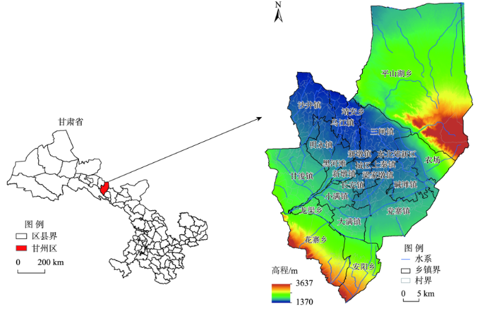
图1
甘州区地理位置和区域概况
Fig.1
Geographical location and regional overview of Ganzhou District, Zhangye City, Gansu Province
1.2 数据来源与处理
表1 三生空间主导功能及包含土地利用类型
Tab.1
| 三生空间 | 主导功能 | 包含土地利用类型 |
|---|---|---|
| 生产空间 | 农业生产 | 水田、旱地 |
| 工业生产 | 工矿等其他建设用地 | |
| 生活空间 | 城镇生活 | 城镇用地 |
| 农村生活 | 农村居民点用地 | |
| 生态空间 | 林草水生态 | 有林地、灌木林、疏林地、其他林地 |
| 高、中、低覆盖度草地 | ||
| 河渠、湖泊、水库坑塘、永久性冰川雪地、滩涂、滩地 | ||
| 其他生态 | 沙地、戈壁、盐碱地、沼泽地、裸土地、裸岩石质地、其他未利用地 |
1.3 研究方法
1.3.1 土地利用转移矩阵
转移矩阵能够具体刻画土地利用结构与功能变化的方向,是一种将土地利用变化面积按矩阵形式排列的方法,该方法来源于系统分析中对系统状态转移的定量描述[29]。土地利用转移矩阵数学公式为:
式中:S为面积;n为土地利用的类型数;i、j分别为研究初期与末期的土地利用类型。
根据土地利用转移矩阵,计算不同用地空间类型的转入转出与净转换面积,以及不同时期不同用地空间类型的转入率和转出率。表达式如下:
式中:Ploss(i),j是转移矩阵中行i空间类型转为j空间类型在行i空间类型净减少中所占的比例,即转出率;Pgain(i),j是转移矩阵中行i空间类型转为j空间类型在行i空间类型净增加中所占的比例,即转入率;Pi,j和Pj,i是转移矩阵表中的单个数值;Pi.是行i空间类型末期面积;P.i 是行i空间类型初期面积。
1.3.2 生态环境质量指数
生态环境质量指数是通过地区的土地利用类型与其生态环境质量背景值之间的关系来表征的[23]。公式如下:
式中:EQt、EQt1和EQt2分别代表t、t1、t2时期生态环境质量指数;EVi代表i类土地利用类型对应的生态环境质量背景值,直接参考李晓文等[30]制定的西北干旱区二级地类生态环境质量背景值;LUi,t代表i类土地利用类型t时的面积;n表示地区土地利用类型数量;R代表t1到t2时生态环境质量的变化率。
1.3.3 移动窗口法
1.3.4 生态贡献率
土地利用转型生态贡献率指某一种土地利用类型变化为另一种土地利用类型所导致的地区生态质量的改变[33]。生态贡献率表达式为:
式中:EI为土地利用转型的生态贡献率;EQt+1、EQt 分别为末期土地利用类型和初期土地利用类型所具有的生态环境质量指数;LA为变化类型空间面积;TA为研究地区总面积。
1.3.5 地理探测器模型
计算公式如下:
式中:q为生态环境质量空间分异影响因素的解释力;N为格网单元总数(N=1689);Nh为变量因子划分的层数h包含的格网单元数;L为变量因子的分层数;σ2为生态环境质量总体方差;
表2 地理探测器因子指标体系及数据处理方法
Tab.2
| 一级指标 | 二级指标 | 基础数据来源 | 数据处理或计算方法 |
|---|---|---|---|
| 地形因子 | 平均海拔(X1) | 30 m DEM数据来源于中国科学院资源环境科学数据中心( | 通过ArcGIS“空间分析—区域分析—按表格显示分区统计”工具,以格网ID作为区域字段提取 |
| 地形起伏度(X2) | |||
| 平均坡度(X3) | |||
| 气候因子 | 年均降水量(X4) | 1 km降水和气温数据来源于中国科学院资源环境科学数据中心( | |
| 年均气温(X5) | |||
| 土地利用 | 土地开发强度(X6) | 30 m土地利用遥感监测数据来源于中国科学院资源环境科学数据中心( | 通过ArcGIS“空间分析—区域分析—面积制表”工具计算各类用地面积,以格网ID作为区域字段提取;然后分别计算:① 土地开发强度=格网内建设用地面积/格网面积;② 土地利用多样性指数=格网内土地利用类型数/总土地利用类型;③ 耕地面积占比=格网内耕地面积/格网面积 |
| 土地利用多样性指数(X7) | |||
| 耕地面积占比(X8) | |||
| 人口与经济 | 人口密度(X9) | 乡镇人口、GDP数据来源于《甘州区农业统计年报》 | 人口密度=乡镇人口/乡镇土地总面积,然后赋给同一个乡镇内的所有格网 |
| 地均GDP(X10) | 地均GDP=乡镇GDP/乡镇土地总面积,然后赋给同一个乡镇内的所有格网 | ||
| 水资源利用 | 地均可利用水资源量(X11) | 乡镇可利用水资源量来源于《甘州区各乡镇及部门单位2015年、2020年、2030年水资源管理控制指标》 | 地均可利用水资源量=乡镇可利用水资源量/乡镇土地总面积,然后赋给同一个乡镇内的所有格网 |
| 节水灌溉面积占比(X12) | 乡镇节水灌溉面积数据来源于《甘州区农业统计年报》 | 节水灌溉面积占比=乡镇节水灌溉面积/乡镇耕地总面积,然后赋给同一个乡镇内的所有格网 | |
| 水资源利用系数(X13) | 乡镇水资源利用效率来源于《甘州区各乡镇及部门单位2015年、2020年、2030年水资源管理控制指标》 | 直接赋给同一个乡镇内的所有格网 | |
| 植被覆盖 | 植被覆盖度(X14) | 30 m植被覆盖度数据来源于中国科学院资源环境科学数据中心( | 通过ArcGIS“空间分析—区域分析—按表格显示分区统计”工具,以格网ID作为区域字段提取 |
2 三生空间转型生态环境效应
2.1 甘州区三生空间转型特征
2.1.1 三生空间时空分布特征
从甘州区土地利用三生空间分布与各类空间面积占比变化来看(图2),1990—2020年空间分布格局相对稳定,总体呈现“核心—边缘”分布模式;但面积占比变化趋势明显,生产和生活空间持续扩张,生态空间总体减少。具体而言:① 农业生产空间主要分布在中部地势低而平坦、河网水系密集利于耕作的乡镇,面积占比持续扩张,共增加6.53个百分点;工业生产空间占比从0.11%增长到0.69%,沿农业与生态空间过渡带扩张。② 农村生活空间比较分散,均匀散落在农业生产空间中,总体呈现扩张趋势,共增加0.39个百分点;城镇生活空间相对集中,占比从0.21%增长到0.92%,沿甘州区核心向外扩张。③ 生态空间主要分布在外围地区,占甘州区国土空间面积占比稳定在60%以上,其中:林草水生态空间先减后增,总体减少2.87个百分点;其他生态空间先增后减,共减少5.35个百分点。就乡镇土地面积占比及变化情况而言,也呈现明显的“核心—边缘”特征。即:平山湖、花寨、安阳等边缘乡镇以生态空间为主,其余乡镇农业生产空间面积占比多年均在50%以上,且黑河两岸乡镇农业生产空间以扩张为主;工业生产空间近10年增加明显,以新墩、梁家墩镇为主,其次为三闸、甘浚、安阳、党寨镇的绿洲边缘区;农村生活空间占比沿城边向外围呈现减少趋势,其中梁家墩、长安、上秦、新墩镇面积占比稳定在9%左右,明显高于其他乡镇。
图2
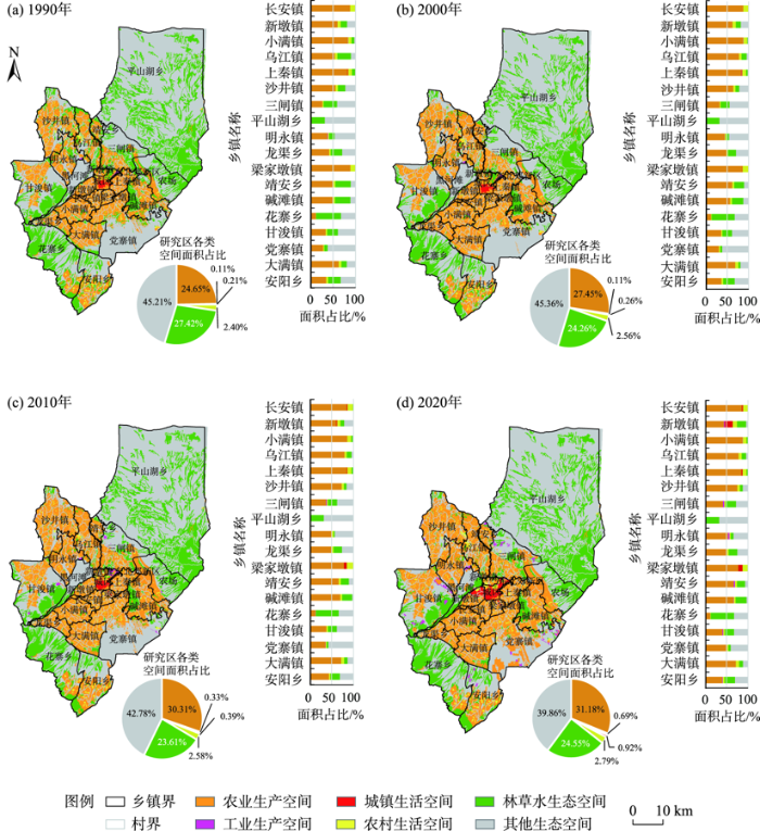
图2
1990—2020年甘州区三生空间演变格局
Fig.2
Spatial evolution pattern of production-living-ecological spaces in Ganzhou District during 1990-2020
2.1.2 三生空间结构转型特征
为分析三生空间结构转型特征,借助转移矩阵模型量化不同空间结构类型转换面积,并计算转换贡献率(表3)。1990—2020年甘州区主要以农业生产空间转入为主,其次为城镇生活、工业生产和农村生活空间的转入,生态空间以转出为主。具体来说,1990—2020年甘州区农业生产空间增加241.2 km2;工业生产、城镇生活和农村生活空间分别增加21.05、26.10和13.30 km2;林草水生态空间和其他生态空间分别减少105.4 km2和196.26 km2。
表3 1990—2020年甘州区三生空间结构变化转移矩阵及转换贡献率
Tab.3
| 类型 | 指标 | 2020年 | 1990年转出 总计/km2 | |||||||||
|---|---|---|---|---|---|---|---|---|---|---|---|---|
| 生产空间 | 生活空间 | 生态空间 | ||||||||||
| 农业 | 工业 | 城镇 | 农村 | 林草水 | 其他 | |||||||
| 1990年 | 生产空间 | 农业 | 面积/km2 | — | 0.69 | 18.17 | 52.19 | 22.80 | 16.44 | 110.29 | ||
| 转入率/% | — | 2.90 | 68.81 | 87.00 | 13.86 | 14.56 | — | |||||
| 转出率/% | — | 0.63 | 16.47 | 47.32 | 20.67 | 14.91 | — | |||||
| 工业 | 面积/km2 | 0.49 | — | 2.15 | 0.02 | 0.13 | 0.02 | 2.81 | ||||
| 转入率/% | 0.14 | — | 8.14 | 0.03 | 0.08 | 0.02 | — | |||||
| 转出率/% | 17.44 | — | 76.51 | 0.71 | 4.63 | 0.71 | — | |||||
| 生活空间 | 城镇 | 面积/km2 | 0.24 | 0 | — | 0 | 0.06 | 0 | 0.30 | |||
| 转入率/% | 0.07 | 0 | — | 0 | 0.03 | 0 | — | |||||
| 转出率/% | 80.00 | 0 | — | 0 | 20.00 | 0 | — | |||||
| 农村 | 面积/km2 | 43.97 | 0.07 | 1.65 | — | 0.66 | 0.33 | 46.68 | ||||
| 转入率/% | 12.51 | 0.29 | 6.26 | — | 0.40 | 0.29 | — | |||||
| 转出率/% | 94.19 | 0.15 | 3.53 | — | 1.42 | 0.71 | — | |||||
| 生态空间 | 林草水 | 面积/km2 | 158.76 | 7.49 | 3.54 | 4.04 | — | 96.03 | 269.86 | |||
| 转入率/% | 45.17 | 31.39 | 13.41 | 6.74 | — | 85.13 | — | |||||
| 转出率/% | 58.82 | 2.78 | 1.31 | 1.50 | — | 35.59 | — | |||||
| 其他 | 面积/km2 | 148.03 | 15.61 | 0.89 | 3.73 | 140.82 | — | 309.08 | ||||
| 转入率/% | 42.11 | 65.42 | 3.38 | 6.23 | 85.63 | — | — | |||||
| 转出率/% | 47.89 | 5.05 | 0.29 | 1.21 | 45.56 | — | — | |||||
| 2020年转入总计/km2 | 351.49 | 23.86 | 26.40 | 59.98 | 164.47 | 112.82 | 739.02 | |||||
| 1990—2020年增减量/km2 | 241.20 | 21.05 | 26.10 | 13.30 | -105.40 | -196.26 | — | |||||
| 1990—2020年增减率/% | 26.62 | 510.92 | 331.35 | 15.09 | -10.46 | -11.82 | — | |||||
从乡镇空间结构演化阶段特征来看(图3): ① 1990—2000年以农业生产空间转入为主,黑河下游片区如沙井、明永、乌江等乡镇尤为突出,东部片区乡镇外延扩张也较为明显。② 2000—2010年除了农业生产空间增加外,林水草生态空间和工业生产空间转入也较为显著。其中:农业生产空间转入具有较强历史继承性,乡镇均以外部延伸方式扩张;林水草生态空间转入涉及三闸、大满、平山湖、碱滩、党寨、安阳等乡镇;工业生产空间转入主要分布在三闸、甘浚、党寨及城区边缘。③ 2010—2020年空间转换面积广泛、类型多样,其中农业生产空间转入以党寨镇扩张为主,三闸、党寨、甘浚、靖安、安阳等乡镇工业生产空间增加凸显,此阶段农村生活和生态空间扩张范围广泛。总体来看,乡镇空间结构演化从“单一农业空间增加”向“转换类型多元化、范围广泛化”转变。
图3
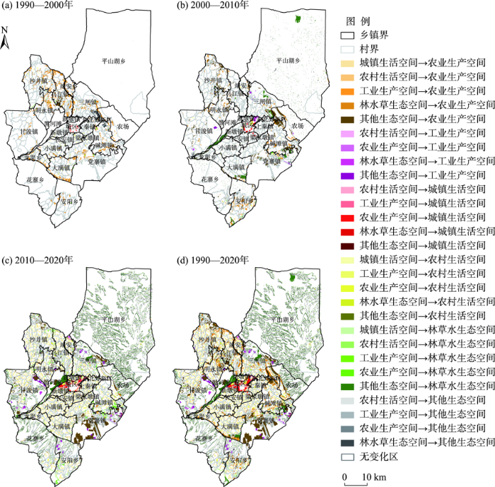
图3
1990—2020年甘州区三生空间结构演化图谱
Fig.3
Evolution map of the spatial structure of production-living-ecological spaces in Ganzhou District during 1990-2020
2.1.3 三生空间功能转变特征
为进一步研究甘州区三生空间功能转变特征,借助转移矩阵将生产、生活、生态空间功能相互转变地区用不同色块进行表达。如图4所示:1990—2010年均以生态转生产功能为主,2010—2020年功能转变具有较为明显的空间分异特征。具体来讲:① 1990—2000年和2000—2010年生态转生产功能转换面积分别为114.84、127.66 km2,空间呈现西北向东南转移特征。② 2010—2020年功能转换复杂多样,但具有明显的片区分异特征。其中:生态转生产功能面积依旧最大,空间上向边缘转移;其次为生产转生态功能空间,镶嵌分布在各镇外围地区;此阶段生活转生产功能空间主要集中在中部,原有城区周边出现生产转生活功能空间集聚区。从乡镇空间功能转变面积占比来看,除梁家墩、长安等城边乡镇以生产与生活功能相互转换为主外,其余乡镇均呈现由“生态转生产为主”向“生产与生活、生态与生产相互转换”的演变规律,2010—2020年乡镇多功能间的转换趋势明显。
图4
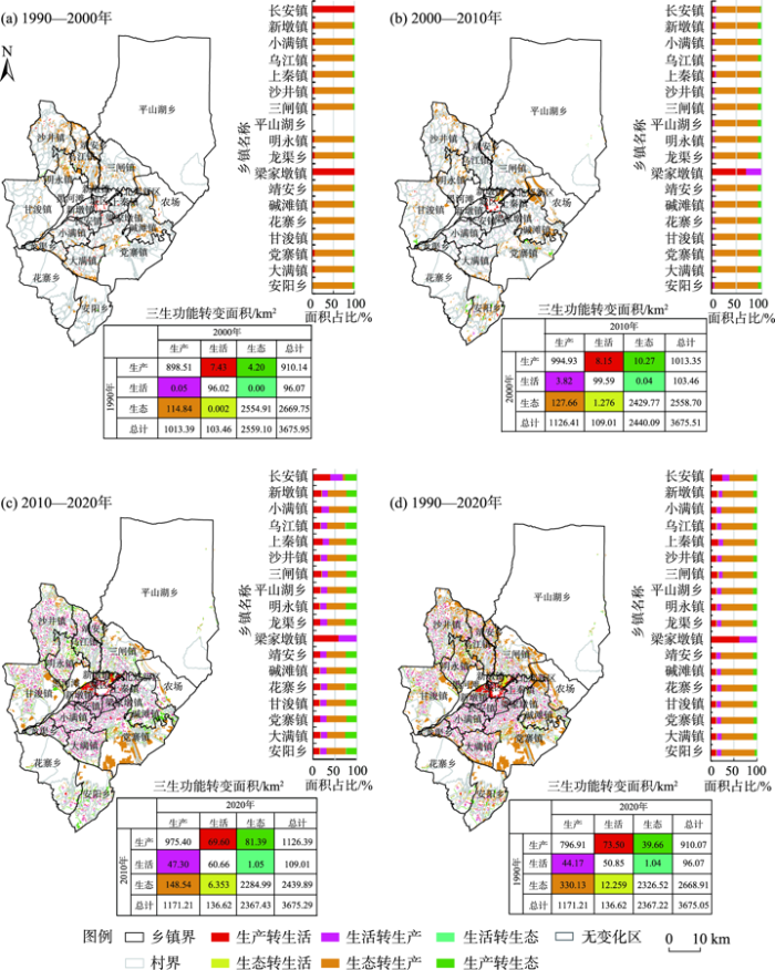
图4
1990—2020年甘州区三生空间功能转变图谱
Fig.4
Evolution map of the spatial function of production-living-ecological spaces in Ganzhou District during 1990-2020
2.2 甘州区三生空间转型生态环境效应
2.2.1 三生空间转型生态环境质量
为分析甘州区内部土地利用转型生态环境效应的空间异质性,利用移动窗口对生态环境质量指数进行重采样(图5)。就甘州区整体而言,1990、2000、2010和2020年生态环境质量指数平均值分别为0.161、0.156、0.162、0.169,表明甘州区生态环境质量先恶化然后改善,但变化幅度不大,生态环境质量指数总体偏低。从空间分异来看,戈壁、沙地等未利用土地面积占比较大的外围乡镇生态环境质量指数相对较低,耕地面积占比较大的中部乡镇生态环境质量指数相对较高,林草水聚集的地区生态环境质量指数最高。就乡镇均值而言,位于黑河下游水资源丰富、有规模水田经营的乌江镇生态环境质量指数多年稳居最高;碱滩镇林地资源聚集,生态环境质量指数排名靠前;其余耕地资源丰富的乡镇排名也相对靠前。而党寨、平山湖、三闸、甘浚等外部乡镇由于荒漠占比较大,从而拉低了整个乡镇的生态环境质量指数。
图5
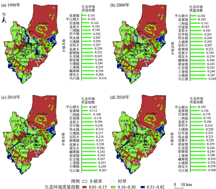
图5
1990—2020年甘州区生态环境质量指数分异格局
Fig.5
Differentiation pattern of eco-environmental quality index in Ganzhou District during 1990-2020
为更加清晰了解生态环境质量变化的空间异质性,分阶段计算生态环境质量指数变化率并统计各乡镇变化情况。如图6所示:① 1990—2000年,因气候干旱及不合理的土地利用导致耕地普遍退化,该阶段生态环境质量指数以减小为主,仅党寨、明永、大满、安阳、甘浚、花寨等乡镇因耕地扩张,生态环境质量指数有所增加。② 2000—2010年,甘州区开始实施了分水计划,该阶段除城区周边梁家墩、新墩因建设发展需求,生活空间增加导致生态环境质量下降外;其余乡镇变化较小或因耕地扩张,农业生产生态环境正向效应显现,生态环境质量指数以增加为主。③ 2010—2020年,随着经济社会发展需求,宅基地、设施农业、乡村振兴示范带、乡村旅游等生产空间扩建,同时农业生产空间规模累积过度消耗水资源,地下水资源开发挤压生态用水,导致林草水生态空间出现退化现象,因此该阶段生态环境质量指数增减变化较为复杂。如:城边梁家墩、长安、上秦镇生活设施建设需求大,碱滩镇规模化的农业设施用地增加,乌江镇大量水田退化为旱地,导致生态环境质量指数减小;以农业生产空间取代其他未利用生态空间的乡镇生态环境质量以增加为主,如党寨、三闸等;平山湖乡草地生态受到保护,同时旅游业和牧业的发展也在破坏生态环境;黑河滩湿地生态空间的打造使新墩镇生态环境质量得到明显改善;甘浚镇乡村振兴示范带建设提升了生态环境质量。
图6
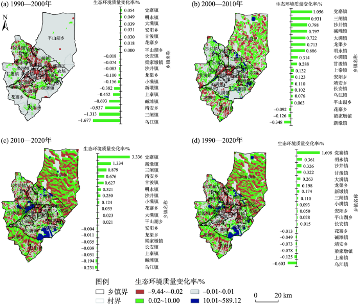
图6
1990—2020年甘州区生态环境质量变化率格局
Fig.6
Spatial pattern of the change rate of eco-environmental quality in Ganzhou District during 1990-2020
总之,1990—2020年甘州区除农业生产空间扩张幅度较大的党寨镇及黑河下游片区粮食作物规模种植的乡镇生态环境指数增加外,其余乡镇生态环境质量则变化不大,同时农业生产空间过度扩张挤压林草水生态空间引起的生态环境负效应正在显现。
2.2.2 三生空间转型生态贡献率
不同国土空间类型的生态环境效应不同,为分析甘州区土地利用转型对生态环境产生的影响,根据三生空间生态环境质量指数及其转换面积计算各类用地转变的生态贡献率及其占比(表4)。对甘州区来说,导致生态环境质量改善的三生空间结构转型主要为其他生态空间→林草水生态空间、其他生态空间→农业生产空间,两者贡献率之和超过90%;导致生态环境恶化的三生空间结构转型主要为林草水生态空间→其他生态空间、林草水生态空间→农业生产空间,二者贡献率之和超过80%。总体来看,1990—2020年甘州区三生空间转型的生态贡献率正负差距不大,总值为正,说明生态环境质量总体向好,但改善力度不大。
表4 1990—2020年甘州区三生空间转型生态贡献率
Tab.4
| 导致生态环境改善 | 导致生态环境恶化 | |||||||
|---|---|---|---|---|---|---|---|---|
| 三生空间结构转型 | 贡献率 | 占比/% | 三生空间结构转型 | 贡献率 | 占比/% | |||
| 1990年 | 2020年 | 1990年 | 2020年 | |||||
| 其他生态空间 | 林草水生态空间 | 0.01168844 | 50.407 | 林水草生态空间 | 其他生态空间 | -0.00797068 | 59.011 | |
| 其他生态空间 | 农业生产空间 | 0.00958827 | 41.350 | 林水草生态空间 | 农业生产空间 | -0.00289475 | 21.431 | |
| 农村生活空间 | 农业生产空间 | 0.00059831 | 2.580 | 农业生产空间 | 其他生态空间 | -0.00106501 | 7.885 | |
| 其他生态空间 | 工业生产空间 | 0.00058609 | 2.528 | 农业生产空间 | 农村生活空间 | -0.00071012 | 5.257 | |
| 农业生产空间 | 林草水生态空间 | 0.00041573 | 1.793 | 林水草生态空间 | 工业生产空间 | -0.00034058 | 2.521 | |
| 其他生态空间 | 农村生活空间 | 0.00019096 | 0.824 | 农业生产空间 | 城镇生活空间 | -0.00024730 | 1.831 | |
| 其他生态空间 | 城镇生活空间 | 0.00004556 | 0.196 | 林水草生态空间 | 农村生活空间 | -0.00012874 | 0.953 | |
| 工业生产空间 | 城镇生活空间 | 0.00002926 | 0.126 | 林水草生态空间 | 城镇生活空间 | -0.00011280 | 0.835 | |
| 农村生活空间 | 林草水生态空间 | 0.00002101 | 0.091 | 农业生产空间 | 工业生产空间 | -0.00001888 | 0.140 | |
| 工业生产空间 | 农业生产空间 | 0.00001321 | 0.057 | 农村生活空间 | 其他生态空间 | -0.00001666 | 0.123 | |
| 工业生产空间 | 林草水生态空间 | 0.00000579 | 0.025 | 农村生活空间 | 工业生产空间 | -0.00000089 | 0.007 | |
| 城镇生活空间 | 农业生产空间 | 0.00000329 | 0.014 | 工业生产空间 | 其他生态空间 | -0.00000070 | 0.005 | |
| 城镇生活空间 | 林草水生态空间 | 0.00000174 | 0.008 | |||||
| 工业生产空间 | 农村生活空间 | 0.00000032 | 0.001 | |||||
| 总计 | 0.02318799 | 100 | 总计 | -0.01350711 | 100 | |||
3 生态环境质量空间分异机制
3.1 单因子探测
以格网大小的生态环境质量指数为被解释变量Y,以与其格网大小一样的因子指标为解释变量X,根据地理探测器模型对甘州区土地利用转型生态环境效应的空间分异格局影响因素进行探测。结果表明: 各因子解释力依次为X9>X10>X14>X5>X6>X8>X3>X2>X13>X12>X11>X1>X7>X4,单因子影响力贡献度q值半数在0.3以下(表5)。就差异来看,人口密度、地均GDP及植被覆盖度对生态环境质量分异的贡献率(均大于0.4)显著强于其他因子,说明这些因子是影响生态环境质量分异的关键驱动力。年均气温、土地开发强度、耕地面积占比及平均坡度对生态环境质量分异的贡献率次之,表明这些因子对生态环境质量影响较大。对干旱区三生空间至关重要的水资源利用条件因2000年以来实施的分水计划,其对生态环境质量空间分异的影响弱化,以及村镇平均海拔由于县域内部之间差异不大,导致对生态环境质量空间分异格局的影响也不大。而对干旱区生态影响最为敏感的土地利用多样性指数和年均降水量因村镇之间差异过小,其影响力也较小。
表5 甘州区生态环境质量空间分异影响因子探测结果
Tab.5
| 因子 | X1 | X2 | X3 | X4 | X5 | X6 | X7 | X8 | X9 | X10 | X11 | X12 | X13 | X14 |
|---|---|---|---|---|---|---|---|---|---|---|---|---|---|---|
| q值 | 0.212 | 0.287 | 0.318 | 0.114 | 0.375 | 0.373 | 0.124 | 0.319 | 0.509 | 0.445 | 0.253 | 0.260 | 0.268 | 0.419 |
3.2 因子交互探测
基于地理探测器交互探测模型,发现生态环境质量的影响以双因子增强和非线性增强2种作用方式呈现显著的协同增强作用效果,近80%的因子交互贡献力q值大于最大单因子贡献力(表6)。具体而言,交互因子对生态环境质量格局影响力靠前的均是以X4为核心分别与植被覆盖度、坡度、气温及人口密度相互作用形成的,贡献力分别为0.860、0.777、0.768、0.725,解释力均超过70%,说明降水量是影响干旱绿洲村镇生态环境质量的核心因子,与其他因子交互对生态环境质量具有显著的非线性增强效应。贡献力次之的依次是以地均GDP、人口密度、土地开发强度为核心的因子交互作用,解释力也在70%以上,说明以这些因子为主与其他因子的交互作用对生态环境质量分异具有重要推动作用。其余因子交互作用的q值虽然相对要低,但对生态环境质量的影响程度要远远高于单一因子。为更加精准分析交互作用的核心因子,统计交互作用贡献力排名靠前因子出现的频率,结果表明X4、X6交互频次最高,说明降水量和土地开发强度是影响干旱绿洲村镇生态环境质量的首要核心因子;为进一步筛选交互作用的核心因子,统计交互作用贡献力大于最大单因子贡献力(0.509)因子出现的频率,依次为人口密度、耕地面积占比、地均GDP和地均水资源量,这些因子是影响干旱绿洲村镇生态环境质量的次要核心因子。
表6 甘州区生态环境质量空间分异影响因子交互探测结果
Tab.6
| 序号 | 交互因子 | q值 | 序号 | 交互因子 | q值 | 序号 | 交互因子 | q值 | 序号 | 交互因子 | q值 |
|---|---|---|---|---|---|---|---|---|---|---|---|
| 1 | X4∩X14(NE) | 0.860 | 24 | X9∩X12(BE) | 0.667 | 47 | X5∩X12(BE) | 0.556 | 70 | X3∩X14(BE) | 0.511 |
| 2 | X3∩X4(NE) | 0.777 | 25 | X5∩X10(BE) | 0.666 | 48 | X5∩X14(BE) | 0.554 | 71 | X1∩X6(BE) | 0.509 |
| 3 | X4∩X5(NE) | 0.768 | 26 | X3∩X11(NE) | 0.666 | 49 | X6∩X10(BE) | 0.550 | 72 | X3∩X12(BE) | 0.505 |
| 4 | X4∩X9(NE) | 0.725 | 27 | X11∩X12(NE) | 0.665 | 50 | X7∩X12(NE) | 0.550 | 73 | X1∩X14(BE) | 0.501 |
| 5 | X2∩X10(BE) | 0.722 | 28 | X4∩X13(NE) | 0.662 | 51 | X2∩X11(BE) | 0.549 | 74 | X13∩X14(BE) | 0.494 |
| 6 | X1∩X4(NE) | 0.721 | 29 | X2∩X4(NE) | 0.661 | 52 | X9∩X13(BE) | 0.546 | 75 | X12∩X14(BE) | 0.487 |
| 7 | X3∩X10(BE) | 0.718 | 30 | X2∩X12(NE) | 0.653 | 53 | X8∩X13(BE) | 0.546 | 76 | X11∩X13(BE) | 0.481 |
| 8 | X10∩X14(BE) | 0.713 | 31 | X2∩X7(NE) | 0.650 | 54 | X7∩X10(BE) | 0.545 | 77 | X11∩X8(BE) | 0.480 |
| 9 | X4∩X12(NE) | 0.712 | 32 | X5∩X7(NE) | 0.650 | 55 | X1∩X8(BE) | 0.543 | 78 | X2∩X5(BE) | 0.479 |
| 10 | X2∩X6(BE) | 0.711 | 33 | X7∩X14(NE) | 0.649 | 56 | X3∩X13(BE) | 0.542 | 79 | X6∩X7(BE) | 0.468 |
| 11 | X3∩X6(BE) | 0.706 | 34 | X9∩X13(BE) | 0.649 | 57 | X4∩X10(BE) | 0.541 | 80 | X1∩X7(NE) | 0.466 |
| 12 | X5∩X9(BE) | 0.705 | 35 | X5∩X11(BE) | 0.648 | 58 | X8∩X11(BE) | 0.541 | 81 | X7∩X13(BE) | 0.433 |
| 13 | X9∩X12(BE) | 0.698 | 36 | X5∩X8(BE) | 0.648 | 59 | X10∩X11(BE) | 0.541 | 82 | X6∩X13(BE) | 0.427 |
| 14 | X6∩X12(BE) | 0.697 | 37 | X9∩X10(BE) | 0.632 | 60 | X3∩X8(BE) | 0.539 | 83 | X6∩X11(BE) | 0.423 |
| 15 | X5∩X6(BE) | 0.692 | 38 | X2∩X9(BE) | 0.630 | 61 | X12∩X13(BE) | 0.539 | 84 | X3∩X5(BE) | 0.421 |
| 16 | X3∩X9(BE) | 0.691 | 39 | X1∩X9(BE) | 0.625 | 62 | X2∩X14(BE) | 0.536 | 85 | X2∩X8(BE) | 0.420 |
| 17 | X9∩X8(BE) | 0.689 | 40 | X1∩X10(BE) | 0.619 | 63 | X1∩X11(BE) | 0.533 | 86 | X1∩X5(BE) | 0.410 |
| 18 | X6∩X14(BE) | 0.682 | 41 | X9∩X8(NE) | 0.608 | 64 | X7∩X8(NE) | 0.533 | 87 | X2∩X3(BE) | 0.404 |
| 19 | X6∩X8(BE) | 0.681 | 42 | X6∩X9(BE) | 0.602 | 65 | X7∩X11(NE) | 0.520 | 88 | X1∩X3(BE) | 0.368 |
| 20 | X3∩X7(NE) | 0.679 | 43 | X4∩X11(NE) | 0.594 | 66 | X8∩X14(BE) | 0.520 | 89 | X1∩X13(BE) | 0.347 |
| 21 | X4∩X6(NE) | 0.677 | 44 | X7∩X9(BE) | 0.584 | 67 | X2∩X13(BE) | 0.519 | 90 | X1∩X2(BE) | 0.345 |
| 22 | X9∩X14(BE) | 0.669 | 45 | X4∩X8(NE) | 0.559 | 68 | X11∩X8(BE) | 0.515 | 91 | X4∩X7(BE) | 0.276 |
| 23 | X11∩X14(BE) | 0.667 | 46 | X5∩X13(BE) | 0.556 | 69 | X1∩X12(BE) | 0.514 |
注:NE(Nonlinear Enhance)为非线性增强,表示两因子交互作用解释程度大于单因子解释程度之和,即q(X1∩X2)>q(X1) + q(X2);BE(Bi-factor Enhance)为双因子增强,表示两因子交互作用解释程度大于任何单因子解释程度,即q(X1∩X2)>max (q(X1), q(X2))。
3.3 空间分异机制
由以上分析可知,对于干旱绿洲来说,人口密度、地均GDP和植被覆盖度是影响村镇生态环境质量的关键因子,而降水量、土地开发强度、耕地面积占比和地均水资源量是核心因子,这些因子与其他自然要素和社会经济要素相互作用共同驱动土地利用类型之间的转换,从而使生态环境质量发生改变(图7)。
图7
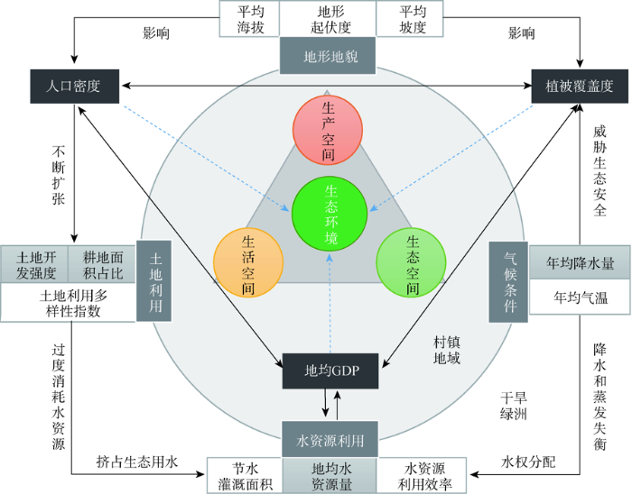
图7
干旱绿洲生态环境质量空间分异形成机制
Fig.7
Formation mechanism of the spatial differentiation of eco-environmental quality in arid oasis
长期以来,在干旱气候影响下绿洲以水资源和土地利用为核心,在人口和经济发展的驱动下,农业生产空间增加带来的生态正效应和生态空间用水压缩引起的土地退化之间不断权衡博弈,使植被覆盖度产生自适应的稳态机制,从而形成区域整体偏低的生态环境格局。村镇作为生产、生活、生态空间多功能集结和社会组织体系的基本单元,在面对外界干扰和冲击时的自组织能力、主动适应性和创新转型能力不同,导致人口流动、经济发展和土地利用模式不同,从而促使生产、生活、生态空间转型重构的方向不同,便塑造了村镇生态环境质量分异格局。对甘州区来说,水资源条件是农业生产和农民生活的重要支撑,水资源越丰富,能够承载更多的人口和社会经济活动,因此,2000年之前中部地势平坦、水系密集的走廊平原村镇是人口和农业生产的主要集聚区;而随着分水计划的实施,补给了外缘村镇的水资源条件,人类活动和经济发展开始向外部扩张转移;近年来,随着农业现代化、乡村振兴、乡村旅游等的开展,村镇土地开发强度增加,产业结构越发多样化,三生空间转型力度加强,到2020年,生态环境质量呈现较为复杂的格局,而不同村镇因发展需求不同,土地利用转型方向和规模不同,便形成了差异化的生态环境质量格局。
4 结论与讨论
4.1 结论
本文以甘州区为例,基于土地利用遥感监测数据,利用转移矩阵对干旱绿洲农业区三生空间转型的时空格局进行研究;采用生态环境质量指数、移动窗口法、生态贡献率分析了1990—2020年干旱绿洲三生空间转型的生态环境效应;引入地理探测器模型对生态环境效应的主要影响因素进行探测并分析空间分异机制。主要结论如下:
(1) 从三生空间分布、结构和功能演变来看,干旱绿洲农业区主要为其他生态、农业生产、林草水生态和农村生活空间,并呈现“核心—边缘”分布模式。1990—2020年,生产和生活空间持续扩张、生态空间总体减少,其中外围乡镇以生态空间为主,内部乡镇农业生产空间面积占比多年稳定在50%以上;空间结构演化从“单一农业空间增加”向“转换类型多元化”转变,功能由“生态转生产为主”向“生产与生活、生态与生产相互转换”演变,2010—2020年乡镇多功能间的转换趋势明显。
(2) 从三生空间转型的生态环境效应来看,1990—2020年生态环境效应总体为正,并呈现先恶化、然后改善、变化幅度不大、总体指数偏低的特征;不同村镇生态环境质量指数及变化差异明显,低值区戈壁、沙地等未利用土地面积占比较大,高值区耕地面积占比较大;导致干旱绿洲农业区生态环境质量改善的主要转换类型为其他生态空间向林草水生态、农业生产空间的转型,导致生态环境恶化的主要转换类型为林草水生态空间向其他生态、农业生产空间的转型;2010—2020年农业生产空间过度扩张引起的生态环境负向效应正在显现。
(3) 从生态环境效应影响因素和分异机制来看,人口密度、地均GDP和植被覆盖度是关键因子,降水量、土地开发强度、耕地面积占比和地均水资源量是核心因子;因子之间相互作用使农业生产空间增加带来的生态正效应和生态空间用水压缩引起的林草水土地退化之间不断权衡博弈,促使干旱绿洲形成整体偏低的生态环境质量总体格局;村镇在面对外界干扰和冲击时的自组织能力、主动适应性和创新能力不同,塑造了生态环境质量分异格局。
4.2 讨论
本文选择中国西北干旱区典型绿洲为研究对象,从栅格和村镇尺度分析了三生空间转型过程及其生态环境效应的空间分异机制,研究结果可为绿洲微观尺度土地利用效率提升、生态环境改善和国土空间优化提供重要参考价值。对东部发达地区来说,农业生产用地被农村和城镇生活用地大量占用是生态环境质量退化的重要原因,农业生产用地转化成水域生态用地是生态环境改善的主要因素[33];而甘州区的结果表明干旱绿洲土地利用转型的生态贡献率主要是由林草水生态空间、农业生产空间与其他未利用生态空间之间相互转换造成的。就生态环境效应空间分异影响因素而言,与目前多数研究[23,25,36]结论一样,自然要素和社会经济要素相互作用共同驱动土地利用类型之间的转换,从而使生态环境质量发生改变,本文进一步分析了村镇生态环境差异形成的机制,丰富了相关理论成果。
生产空间决定生活空间,继而影响生态空间,在以农业生产为主的干旱绿洲地区,农业生产空间对于整个系统而言是串联多种空间形态和社会组织的纽带,也是决定干旱绿洲生态环境质量的关键。绿洲内的物质循环与能量流动的相互作用使系统具有自我维持和调节能力,但系统的这种稳态机制是有限的[37],当人口和经济发展干扰超过系统可调节或可承载能力范围时,系统平衡将被破坏,在干旱气候影响和计划用水制度下,水资源作为绿洲生产、生活与生态的关键纽带,其总量是固定的,水资源利用必须控制在系统韧性范围之内。1990—2020年甘州区三生空间转型带来的生态环境效应虽然总体为正,但不断扩张的耕地和生活空间已经造成地下水普遍过度开采,如沙井、明永、新墩、小满、大满、长安、梁家墩、党寨、碱滩、上秦、甘浚、三闸12个乡镇及张掖市工业园区,共超采水量7499.24万m3(数据来源于甘州区水务局),出现植被退化、土地沙化和荒漠化现象,危及区域粮食安全和生态安全,制约经济社会的可持续发展和生态环境的良性循环。对干旱绿洲来说,以水资源为约束条件,科学评估人口和耕地适宜规模、精准测算三生空间的最佳面积比例,注重农业经济和生态保护协调发展应成为未来决策部门关注和科学研究的重点。
自20世纪90年代末以来,多功能发展已经成为欧洲后生产主义时代农业和农村发展的新范式[38],随着中国经济社会发展迈入后工业化时代,农业和农村地域由传统单一的农产品生产向生产、生活、生态多功能协调发展转变[39],除了提供农林业等生产活动,还具有社会保障、休闲旅游、文化传承、生态保育、环境维护等多元功能,土地利用的多功能性也随之体现,甘州区长期以来以农业生产为主,乡村振兴战略提出以后村镇多功能价值才得以挖掘显现[40]。此外,土地利用转型具有显性和隐性形态[8],三生空间转型也是如此,但囿于微观尺度长时间社会经济数据收集难度大等原因,本文仅侧重于土地利用主导功能的显性转型研究,后续应增加表征土地利用隐性形态与多功能特征的社会经济数据,进一步揭示干旱绿洲土地利用多功能之间的转型特征,为绿洲国土空间优化和农业农村可持续发展提供更为科学的参考依据。
参考文献
Resource and environmental pressures on the transformation of planting industry in arid oasis
[J].
西北干旱区耕地扩张原因的实证分析
[J].
An empirical analysis of the causes of farmland expansion in Northwest China
DOI:10.11820/dlkxjz.2011.05.014
[本文引用: 1]

In the past decade, farmland expanded remarkably in many regions in the arid Northwest China. These changes occurred in the context of rapid loss of farmland and exacerbated degradation of local environments in China. Therefore, better understanding their causes is helpful for understanding land use changes in China and crucial for developing effective conservation and ecosystem management plans. In literature, it is suggested that local population growth, technological progress in agriculture, and policy prompting are the main causes. However, these suggestions root in statistical correlation without further empirical research. In this paper, we took Xinjiang region as the sample, and evaluated the rationality of these suggestions based on changes in sown area. The results imply that technological progress in agriculture and policy prompting assuredly accelerate the expansion of farmland, as the sown areas of leading crops increase at higher rates in response to the adoption of technologies and policies. Meanwhile, the increasing need of food due to population growth does not consequentially cause the expansion of farmland, as the sown area of food plants decreases in the same period. From the results of sown area changes, the pursuing for scale benefit of crops with higher returns can be inferred as the main cause of farmland expansion.
Effects of human activities on the eco-environment in the middle Heihe River Basin based on an extended environmental Kuznets curve model
[J].DOI:10.1016/j.ecoleng.2014.04.020 URL [本文引用: 1]
Land use transitions: Socio-ecological feedback versus socio-economic change
[J].DOI:10.1016/j.landusepol.2009.09.003 URL [本文引用: 1]
Global consequences of land use
[J].Land use has generally been considered a local environmental issue, but it is becoming a force of global importance. Worldwide changes to forests, farmlands, waterways, and air are being driven by the need to provide food, fiber, water, and shelter to more than six billion people. Global croplands, pastures, plantations, and urban areas have expanded in recent decades, accompanied by large increases in energy, water, and fertilizer consumption, along with considerable losses of biodiversity. Such changes in land use have enabled humans to appropriate an increasing share of the planet's resources, but they also potentially undermine the capacity of ecosystems to sustain food production, maintain freshwater and forest resources, regulate climate and air quality, and ameliorate infectious diseases. We face the challenge of managing trade-offs between immediate human needs and maintaining the capacity of the biosphere to provide goods and services in the long term.
Impact assessment of land use policies: Introduction
[J].DOI:10.1016/j.landusepol.2013.03.010 URL [本文引用: 1]
区域土地利用转型分析: 以长江沿线样带为例
[J].
Analysis on regional land use transition: A case study in transect of the Yangtze River
城镇化背景下中国农区土地利用转型及其环境效应研究: 进展与展望
[J].
DOI:10.11867/j.issn.1001-8166.2018.05.0455
[本文引用: 1]
农区是保障我国经济社会可持续发展的根基,基于土地利用转型这一独特视角前瞻性地研究城镇化进程对农区环境的影响及其调控途径意义重大。现有研究在着眼于城镇化驱动土地利用转型及其“格局—过程—效应—调控”方面的系统性分析尚显不足,未来可从宏观到中(微)观尺度、理论到实践2条研究主线协同推进相关研究。在此过程中需解决的关键问题有:土地利用隐性形态变化的定量识别与模拟,转型进程中环境效应的产生机理与调控位点,以及耦合经济与环境多重情景的土地利用转型调控机制与合理模式。未来土地利用转型及其环境效应研究应坚持综合的方向,体现多维、动态视角,探索多学科、多尺度的综合分析方法和手段,为构建农区“土地—环境—经济”协同发展的动态耦合机制、有效促进城乡一体化发展提供科学决策依据。
Land use transitions under urbanization and their environmental effects in the farming areas of China: Research progress and prospect
DOI:10.11867/j.issn.1001-8166.2018.05.0455
[本文引用: 1]
Farming areas are the foundation of China's socio-economic sustainable development. The forward-looking studies on environmental effects of urbanization process as well as its regulation countermeasures from the aspects of land use transitions are of great significance. Previous researches show insufficient performance in the aimed issue of urbanization-driven land use transitions and the systematic analysis from the aspects of “pattern-process-effect-regulation”. Future researches can be arranged by two main lines, namely, the studies from macro scale to medium scale and micro scale, and the studies from theories to practices. Three key issues need to be addressed in the above-mentioned work, i.e., the quantitative identification and simulation of changes on recessive land use morphology, the generation mechanism and regulatory points of environmental effects during transition process, the regulation mechanism and rational mode of regional land use transitions coupling with environment and economic evolution. Future researches on land use transitions and their effects should adhere to the comprehensive direction, reflect multi-dimensional and dynamic perspectives, and explore multi-disciplinary and multi-scale comprehensive analysis means, so as to provide scientific decision-making basis for establishing the dynamic-coupling mechanism of “land-environment-economy” coordinated development as well as effectively promoting integrated urban-rural development.
Effects of land use transitions due to rapid urbanization on ecosystem services: Implications for urban planning in the new developing area of China
[J].DOI:10.1016/j.habitatint.2014.10.011 URL [本文引用: 1]
Land use transition and rural spatial governance: Mechanism, framework and perspectives
[J].
DOI:10.1007/s11442-020-1784-x
[本文引用: 1]
The pattern for utilization of rural space is closely related to rural transformation development (RTD). The problem of rural space utilization is an important manifestation of the uncoordinated relationship between land use patterns and rural development status during a transformation period. Considering the rural space utilization issue, this article seeks to analyze the interaction mechanisms between land use transition (LUT) and rural spatial governance and then build a rural spatial governance analysis framework based on LUT. Also, the paper explores the internal relationship between rural spatial governance and rural vitalization and discusses the research prospective of the interaction. The study found that: (1) Rural space utilization has systemic problems such as limited development space, ill-defined ownership and poor organization, which have become important obstacles for rural development. (2) The uncoordinated relationship between LUT and RTD is an important reason for the dilemma surrounding rural space utilization. (3) The LUT provides a basis for determining the timing of rural spatial governance, specifying spatial governance objectives, and clarifying rural spatial governance methods. (4) The construction of a comprehensive analysis framework of “matter-ownership-organization” of rural space based on the LUT has created conditions for the orderly promotion of rural spatial governance. (5) Rural spatial governance which facilitates the integration of urban-rural development is an important foundation for rural vitalization. (6) Interaction analysis of LUT, RTD and rural spatial governance is conducive to facilitating research on the operational mechanism of rural regional systems and to expanding the research field of rural geography.
Land use transitions and their effects on water environment in Huang-Huai-Hai Plain, China
[J].DOI:10.1016/j.landusepol.2015.04.023 URL [本文引用: 1]
土地利用转型的生态系统服务价值效应分析: 以湖南省为例
[J].
DOI:10.11821/dlyj201504008
[本文引用: 1]
以1995年、2000年、2005年和2010年四期Landsat TM影像解译数据和社会经济数据为基础,借助ArcGIS分析手段,探讨了期间湖南省的土地利用转型情况。借鉴全球生态系统服务价值的最新研究成果,结合中国实际情况对生态系统服务价值系数进行了修订,进而对湖南省土地利用转型导致的生态系统服务价值变化进行了测度和分析。结果表明:1995-2010年,湖南省土地利用发生明显变化,主要表现为城乡建设用地增加及耕地和草地面积的减少;1995-2000年,湖南省生态系统服务价值略有提升,由8807.8亿元变为8829.5亿元,增加0.25%。但自2000年以后,生态系统服务价值持续下降,由2000年的8829.5亿元降至2010年的8770.9亿元,下降0.66%。最后,提出保障湖南省生态系统服务功能的土地利用优化配置建议。
Effects of land use transitions on ecosystem services value: A case study of Hunan Province
DOI:10.11821/dlyj201504008
[本文引用: 1]
With the rapid development of Chinese economy, many negative effects of land use transitions under the pressure of rapid urbanization on local ecological system and environment have occurred. This paper examines the dynamic patterns of land use transitions in Hunan province, using high-resolution Landsat TM (Thematic Mapper) data in 1995, 2000, 2005 and 2010, and socio-economic data from both research institutes and government departments, and assesses the changes of ecosystem services value (ESV) by drawing a connection between the observed land use dynamics and the evaluation of ESV, based on the latest research of Costanza et al. and some revisions adapted to the situation of China. The outcomes indicated that, during the period from 1995 to 2010, the land use changed significantly, characterized by the increase of construction land and the decrease of cultivated land and grassland; ESV of the study area decreased by 0.42%, from 880.78 to 877.09 billion RMB, due to the losses of large quantities of ecological land to construction land. Then, some of the major implications for improving the land use of Hunan province were discussed. The authors argue that it is fundamental to meet the demand of construction land for socio-economic development, meanwhile, to protect regional ecosystem services function and maintain its stability; only in this way Hunan province may realize the sustainable use of ecological resources in the process of rapid urbanization, as well as the integration of economic, social and ecological benefits.
面向国土空间优化的三生空间研究进展
[J].
DOI:10.18306/dlkxjz.2017.03.014
[本文引用: 1]
解决经济高速增长、社会快速转型中存在的国土开发秩序混乱和资源环境代价沉重等问题是人文—经济地理学在区域可持续发展领域的重大科学命题。党的十八大报告将优化国土空间开发格局作为生态文明建设的首要举措,并提出“促进生产空间集约高效、生活空间宜居适度、生态空间山清水秀”,由此构成的“三生”空间成为构建空间规划体系、完善国土空间开发保护制度和各类尺度空间落实主体功能区规划的重要基础。本文围绕国土空间优化和区域可持续发展目标,对国内外“三生”空间相关文献进行系统梳理,紧紧围绕“三生”空间的数量配比和空间配置两个科学问题进行综述,按照精度深化和尺度细化的要求,集中在“三生”功能分类、空间识别、空间优化等内容,从而勾勒出三生空间研究的框架体系。今后应重视三生空间动态演化,促进各尺度适宜性评价的统一和整合,响应“多规合一”的实践需求,最终服务于国土空间格局优化。
A literature review on optimization of spatial development pattern based on ecological-production-living space
DOI:10.18306/dlkxjz.2017.03.014
[本文引用: 1]
In the process of rapid economic growth and social restructuring, solving the problems such as spatial development disorder and costly resources and environmental impact has been an important scientific proposition of regional sustainable development in the field of human-economic geography. In accordance with the report to the Eighteenth National Congress of the Communist Party of China, optimizing spatial development pattern nationally is placed as the primary measure of ecological progress, followed by the specific requirements stated as "the space for production is used intensively and efficiently, the living space is livable and proper in size, the ecological space is unspoiled and beautiful." Shaping the ecological-production-living space by following these requirements will become the foundation of the spatial planning system. Moreover, it also contributes to improving the protection system of spatial development and implementing major function oriented zoning at all scales. Revolving around the target of optimizing geographical space and regional sustainable development, this article systematically reviews existing literature on ecological-production-living space both in China and internationally, focusing on the quantitative proportion and spatial layout of ecological-production-living space. Following the requirements of improving precision and increasing spatial resolution and with a focus on functional classification, spatial identification, and spatial development pattern optimization, this article finally put forward the research framework of ecological-production-living space. To promote the progress of theoretical research and practical applications on ecological-production-living space, the following measures can be implemented: (1) Establish an improved research framework and technical process through multidisciplinary partnerships. (2) Expand the scope of basic units of analysis. (3) Explore new methods for function identification and attach more importance to the dynamic evolution of ecological, production, and living spaces. (4) Promote the integration of suitability evaluation at different scales. (5) Meet the practical needs of multiple-planning integration and ultimately serve the national efforts of optimizing the spatial development pattern.
“三生”空间内涵与空间范围的辨析
[J].
Discussion on the concept definition and spatial boundary classification of "production-living-ecological" space
国土“三生空间”分类及其功能评价
[J].
"Production-living-ecological" space classification and its functional evaluation
中国“三生空间”分类评价与时空格局分析
[J].
DOI:10.11821/dlxb201707013
[本文引用: 1]
本文在探究“生产—生活—生态”三生空间理论内涵的基础上,分析了土地利用功能与土地利用类型的辩证关系,依据土地利用现状分类国家标准,建立了三生空间分类与评价体系,揭示了1990-2010年间中国三生空间的格局及其变化特征。结果表明:① 生产空间主要分布在胡焕庸线东南侧的主要城市群及粮食主产区,其扩张区域主要分布于东北平原、新疆西北、宁夏、兰州—西宁、四川盆地、环渤海、长三角、厦漳泉、珠三角等地区,缩小区域主要分布在黄土高原、呼伦贝尔大草原、江汉平原、闽南丘陵等地区;② 生活空间主要集中在全国主要城市及城市群,整体上呈现“东高西低、北高南低;大分散、小集聚”的空间格局,其扩张过程表现为环渤海、长三角、珠三角三大城市群的大规模、区域式扩张和各主要省会城市的小规模、点状式扩张。③ 生态空间主要分布在胡焕庸线西北侧,整体呈现“西高东低,南高北低”的空间格局;④ 工业化、城镇化是中国三生空间变化的基本动力,西北和东北地区的农田开垦、华北平原和三大城市群的城镇化建设、黄土高原的退耕还林等是导致三生空间区域差异的主要原因。本文可以为三生空间的分类规划和优化决策提供参考依据。
Classification evaluation and spatial-temporal analysis of "production-living-ecological" spaces in China
DOI:10.11821/dlxb201707013
[本文引用: 1]
This paper created a land use classification system of production-living-ecological spaces based on analyzing the theories of production-living-ecological spaces and commanding the dialectical relationships between land use types and land use functions. The classification system perfectly connected to the state standard of land use classification. Based on this system, we examined the spatial and temporal patterns of production-living-ecological spaces in China between 1990 and 2010. The results showed that: (1) The production spatial pattern almost unchanged between 1990 and 2010, and the production spaces were mainly distributed in the southeast of the Hu Huanyong Line, including Northeast China Plain, northwest Xinjiang, Ningxia, Lanzhou-Xining, Sichuan Basin, Bohai Rim, Yangtze River Delta, Xiamen-Quanzhou-Zhangzhou, and Pearl River Delta, where China's urban agglomerations and main grain production areas were located in. (2) Living spaces were mainly distributed in China's urban agglomerations and cities, showing a spatial pattern of "high in the east and north regions, while low in the west and south regions". Its spatial expansion varied in different areas. Large-scale expansion of living spaces appeared in the Bohai Rim, Yangtze River Delta and Pearl River Delta, while small-scale and point-type expansion in the major provincial capitals. (3) Ecological spaces were mainly distributed in the northwest of the Hu Huanyong Line, showing a spatial pattern of "high in the west and south regions, while low in the east and north regions". The expansion of ecological spaces were mainly in the Loess Plateau, Hulun Buir Glassland and Tianshan Mountains, while the reduction of ecological spaces were mainly in the Northeast China Plain, North China Plain, Yangtze River Delta, Pearl River Delta, Ningxia and Xinjiang. (4) Industrialization and urbanization were the basic driving powers of changes of China's production-living-ecological spaces. The main reasons for regional spatial differences across China included farmland cultivation in Northwest and Northeast China, rapid urbanization in North China, Bohai Rim, Yangtze River Delta and Pearl River Delta, and reversion of farmland to forestland in the Loess Plateau. This research was valuable for the studies on classification and evaluation of production-living-ecological spaces.
中国“三生用地”分类及其空间格局
[J].工业化、城市化和经济的快速发展导致中国人地关系紧张,争地现象多发。为兼顾粮食安全、经济发展和生态保护之间的关系,需要协调土地不同功能用地的矛盾。现行的土地利用分类体系,注重土地的生产、生活功能,对生态功能考虑不够。本研究以土地的主体功能为出发点,兼顾其他功能,纳入生态用地的概念,构建了“三生用地”分类体系,统筹生产、生活和生态用地空间。通过先分区再分类的方法,提取了中国“三生用地”的分布范围。结果表明,生态用地、生态生产用地、生产生态用地和生活生产用地等面积分别为603.70万km<sup>2</sup>、135.38万km<sup>2</sup>、200.19万km<sup>2</sup>和20.73万km<sup>2</sup>,各占国土面积的62.89%、14.10%、20.85%和2.16%。生态用地主要分布在中西部,生态生产用地因其生产功能具有明显的地域分异,生产生态用地和生活生产用地则更集中分布在东部地区。
An ecological-living-industrial land classification system and its spatial distribution in China
Rapid development of industrialization,urbanization and economy causes tension in the human-land relationship. To take into account the relationship between food security,economic development and ecological protection,one needs to coordinate contradictions and conflicts between different functional land types. The current land use classification system emphasizes the industrial and living function of lands but insufficiently considers ecological function. This study built an Ecological-living-industrial Land Classification System from the perspective of land functions incorporating the concept of ecological land. The new land classification is more suitable to coordinate ecological,living and industrial land spaces. The Ecological-living-industrial Land Classification System includes three levels. The first level includes four major types:ecological regulation land,ecological-industrial land,industrial land,and living-industrial-ecological land. The second level subdivides dominant functions into 15 functional land categories. The third level is based on land cover types. According to zoning and re-classification,we extracted ecological-living-industrial land and their spatial distribution at a national scale. The area of ecological regulation land,ecological-industrial land,industrial land,and living-industrial land area are 6 037 000km2,1 353 800km2,2 001 900km2 and 207 300km2 respectively;accounting for 62.89%,14.10%,20.85% and 2.16% of total area,respectively. Ecological land are mainly locate in central and western China, ecological-industrial land reflects obvious regional differentiation,and industrial-ecological land and living-industrial land are concentrated in eastern China.
“三生空间”统筹的科学基础与优化途径探析
[J].
Discussion on scientific foundation and approach for the overall optimization of "production-living-ecological" space
DOI:10.31497/zrzyxb.20210501 URL [本文引用: 1]
“生产—生活—生态”空间识别与优化研究进展
[J].
DOI:10.18306/dlkxjz.2020.03.014
[本文引用: 1]
“生产-生活-生态”(简称“三生”)空间识别与优化研究是在识别现状空间结构、格局及问题的基础上,对未来空间进行优化布局,实现空间的均衡、可持续性发展,是一种更具综合性的国土空间分区方式,已成为当前学术前沿和国土空间规划亟需解决的实践问题。论文通过文献调研法、对比法和归纳法,系统梳理了“三生”空间概念内涵、识别与优化研究现状。目前,“三生”空间识别研究取得了阶段性成果,但“三生”空间形成的内在机理与概念探讨不足,“三生”空间的定量识别方法与技术体系研究有待完善,“三生”空间动态演化及驱动机制、空间冲突诊断和问题分析较为薄弱,“三生”空间优化理论和技术体系尚处于初级阶段。未来,应形成“三生”空间识别与优化“质”“量”观,借鉴国际空间规划已有的研究成果,以“‘三生’空间形成机理与概念界定、定量识别、演化机制挖掘、冲突诊断与问题分析、优化调控与模拟”为主线,系统构建“三生”空间识别与优化的理论与技术体系;同时,重视具有水平方向和垂直方向特征的山区“三生”空间识别与优化研究。
Research progress of the identification and optimization of "production-living-ecological" spaces
基于“三生”功能的柳州市国土空间适宜性评价
[J].
Evaluation of national land use and space for functions of "production, life, ecology", Liuzhou
基于“三生空间”的福建省城市综合承载力研究
[J].
Research on urban comprehensive bearing capacity of Fujian Province based on "production, living and ecological" space
中国“三生空间”演变特征、生态环境效应及其影响因素
[J].
The evolution of "production-living-ecological" space, eco-environmental effects and its influencing factors in China
DOI:10.31497/zrzyxb.20210503 URL [本文引用: 3]
基于“三生空间”的土地利用转型与生态环境效应: 以长江三角洲核心区为例
[J].
DOI:10.13249/j.cnki.sgs.2018.01.011
[本文引用: 1]
以长江三角洲核心区为例,利用1990、2000、2010年3期遥感影像解译获取土地利用变化数据,按照“生产-生态-生活”土地利用主导功能分类,通过土地利用转移矩阵、生态环境质量指数、土地利用转型的生态贡献率等方法,定量分析长江三角洲地区土地利用转型、时空格局特征与生态环境效应。结果表明:① 1990~2010年,长三角地区基于“三生用地”的土地利用转型表现为生产用地减少,生态用地稳定,及生活用地快速增加。② 长三角地区生态环境质量指数从1990年的0.470持续降至2010年的0.444,整体质量有所恶化,较高质量区和高质量区面积与比重保持稳定。③ 1990~2010年,长三角地区同时存在生态改善和恶化的两种趋势,生态环境改善小于环境恶化的趋势。城镇和农村生活用地、工矿生产用地对农业生产用地的挤占则是导致生态环境质量恶化的重要原因。
Land use transformation based on ecological-production-living spaces and associated eco-environment effects: A case study in the Yangtze River Delta
DOI:10.13249/j.cnki.sgs.2018.01.011
[本文引用: 1]
According to land use classification based on leading function of production, ecology and living, we take the Yangtze River Delta as a case and made use of land use change/cover data in 1990, 2000 and 2010 respectively by remote sensing interpretation obtained from Landsat TM and ETM+. And then we quantitatively analyze the characteristics of land functional structural and spatial transformation as well as its eco-environmental impacts. The methods discussed in the article include land use transfer matrix, index of regional eco-environmental quality and ecological contribution ratio of different kinds of land changes. The results show that: 1) Land use changes in the Yangtze River Delta is chiefly manifested as the area decrease of productive land, stability of ecological land and increase of living land. Main types of transformation are the conversion from agricultural productive land into urban and rural living land, and that from water and pasture ecological land into agricultural productive land, which makes land use structure maintain the dynamic balance. 2) The index of eco-environmental quality in the Yangtze River Delta has been reduced from 0.470 in 1990 to 0.444 in 2010, therefore the overall quality has deteriorated. The percent of the lower mass area is about 45%, which constitutes the main body of land use environment quality. The proportion and the size of higher quality and high quality regions remain stable. And then, due to the rapid expansion of urban and rural living land, make the expansion of low mass region as “hot spots”. The regions of relatively low quality and quality mainly distributed in the periphery of the hot zone, and form the “core - periphery” structure with the low quality region in space. 3) From 1990 to 2010, there are two trends of ecological improvement and deterioration in the Yangtze River Delta region. In the whole, the eco-environment quality of land use pattern declines slightly. The critical factor of eco-environmental improvement is the conversion from agricultural productive land into woodland, water and pasture and that of eco-environmental degradation is the large occupation of agricultural productive land by rural and urban living land.
“三生”空间视角下土地利用转型的生态环境效应及驱动力: 以甘肃省为例
[J].
Eco-environmental effects of land use transformation and its driving forces from the perspective of "production-living-ecological" spaces: A case study of Gansu Province
土地利用转型时空演变及其生态环境效应: 基于长江经济带127个地级市的实证研究
[J].
Spatiotemporal change of land-use transformation and its eco-environmental response: A case of 127 counties in Yangtze River Economic Belt
基于“三生空间”的土地利用主导功能转型及其生态环境响应: 以重庆市巴南区为例
[J].
A study land use function transformation based on "ecological-production-living" spaces and associated eco-environment response: A case study of Banan District
基于“三生空间”的土地利用功能转型及生态服务价值研究: 以福州新区为例
[J].
Study on transition of land use function and ecosystem service value based on the conception of "production, living and ecological" space: A case study of the Fuzhou New Area
DOI:10.31497/zrzyxb.20171197 URL [本文引用: 1]
关于区域土地利用变化指数模型方法的讨论
[J].
Discussion on the index method of regional land use change
DOI:10.11821/xb200305001
[本文引用: 1]
Recently, many sorts of index models have been widely adopted in the analysis of land use change in China. And they do play an important role in summarizing the rule of regional land use changes. However, according to the present research papers, there are some confusions and misuses in their applications, which root in faultiness, abnormity and misunderstanding of the indices or index calculation. By detailed exploration of the indices embedded in research materials, three classifications are identified on the basis of their application purposes: the change of regional land resources (change rate index and level change index), the direction of land use change (transition matrix and flow direction rate) and the spatial pattern of land use change (dynamic degree, relative change rate, adjacency degree, barycenter, frequency degree and importance degree). Then all the indices listed above are discussed under the purposed framework, including their concepts, calculation methods, application fields, misuses, and some application suggestions. This paper also gives a remark in the end that the research of land use change needs new breakthroughs in both theory and methodology. Index method is only a simple kind with limited functions, and much more efforts should be devoted to integrative, predictive methods in the coming days.
西北干旱区城市土地利用变化及其区域生态环境效应: 以甘肃河西地区为例
[J].
The urban land use transformations and associated effects on eco-environment in Northwest China arid region: A case study in Hexi region, Gansu Province
基于移动窗口法的肃州绿洲化与景观破碎化时空变化
[J].
Spatiotemporal change and landscape fragmentation in Suzhou oasis using the moving window method
基于移动窗口法的岷江干旱河谷景观格局梯度分析
[J].
Gradient analysis of dry valley of Minjiang River landscape pattern based on moving window method
区域发展过程中土地利用转型及其生态环境响应研究: 以江苏省为例
[J].
DOI:10.13249/j.cnki.sgs.2013.012.1442
[本文引用: 2]
以江苏省为例,利用1985年、1995年、2005 年和2008 年4期遥感影像解译获取的土地利用变化数据,按照“生产-生态-生活”土地利用主导功能分类,通过土地利用转移矩阵、重心转移、区域生态环境质量指数、土地利用变化类型生态贡献率等方法,定量研究江苏省土地利用功能结构转型、空间转型特征及其生态环境响应规律。研究表明:① 1985~2008年,江苏省土地利用主导功能结构变化主要表现为生产用地面积的减少,生态用地、生活用地面积的增加。主要的转化类型为农业生产用地转化为农村生活用地、城镇生活用地,牧草生态用地转化为农业生产用地。② 1985~2008年,农业生产用地、生态用地、农村生活用地空间分布的不均衡性进一步加剧,工矿生产用地空间分布的不均衡性有所缓和,城镇生活用地空间分布经历了先加剧后有所缓和的阶段。③ 1985~2008年,江苏省的生态环境质量稍有下降,其中农业生产用地被农村和城镇生活用地大量占用是生态环境质量退化的主导因素,农业生产用地转化成水域生态用地是区域生态环境改善的主要因素。
Land use transformation and its eco-environmental response in process of the regional development: A case study of Jiangsu Province
DOI:10.13249/j.cnki.sgs.2013.012.1442
[本文引用: 2]
According to land use classification based on leading function of production, ecology and living, we took Jiangsu Province as a case study and made use of land use change/cover data in 1985, 1995, 2005 and 2008 respectively by remote sensing interpretation obtained from Landsat TM and ETM+. And then we quantitatively analyzed the characteristics of land functional structural and spatial transformation as well as its eco-environmental impacts. The methods discussed in the article include land use transfer matrix, gravity center model, index of regional eco-environmental quality and ecological contribution ratio of different kinds of land changes. The results show: 1) Land use changes in Jiangsu Province is chiefly manifested as the area decrease of productive land and increase of ecological and living land. Main types of transformation are the conversion from agricultural productive land into rural and urban living land, and that from water and pasture ecological land into agricultural productive land. 2) From 1985 to 2008, the imbalance of agricultural productive land, ecological land and the distribution of rural living space are further sharpened while that of mining productive land is weakened. And the imbalance of spatial distribution of urban living land is intensified at the beginning while then slow down. 3) From 1985 to 2008, the eco-environment quality of Jiangsu Province declines slightly. The critical factor of eco-environmental degradation is the large occupation of agricultural productive land by rural and urban living land and that of eco-environmental improvement is the conversion from agricultural productive land into water.
地理探测器: 原理与展望
[J].
DOI:10.11821/dlxb201701010
[本文引用: 1]
空间分异是自然和社会经济过程的空间表现,也是自亚里士多德以来人类认识自然的重要途径。地理探测器是探测空间分异性,以及揭示其背后驱动因子的一种新的统计学方法,此方法无线性假设,具有优雅的形式和明确的物理含义。基本思想是:假设研究区分为若干子区域,如果子区域的方差之和小于区域总方差,则存在空间分异性;如果两变量的空间分布趋于一致,则两者存在统计关联性。地理探测器q统计量,可用以度量空间分异性、探测解释因子、分析变量之间交互关系,已经在自然和社会科学多领域应用。本文阐述地理探测器的原理,并对其特点及应用进行了归纳总结,以利于读者方便灵活地使用地理探测器来认识、挖掘和利用空间分异性。
Geodetector: Principle and prospective
DOI:10.11821/dlxb201701010
[本文引用: 1]
Spatial stratified heterogeneity is the spatial expression of natural and socio-economic process, which is an important approach for human to recognize nature since Aristotle. Geodetector is a new statistical method to detect spatial stratified heterogeneity and reveal the driving factors behind it. This method with no linear hypothesis has elegant form and definite physical meaning. Here is the basic idea behind Geodetector: assuming that the study area is divided into several subareas. The study area is characterized by spatial stratified heterogeneity if the sum of the variance of subareas is less than the regional total variance; and if the spatial distribution of the two variables tends to be consistent, there is statistical correlation between them. Q-statistic in Geodetector has already been applied in many fields of natural and social sciences which can be used to measure spatial stratified heterogeneity, detect explanatory factors and analyze the interactive relationship between variables. In this paper, the authors will illustrate the principle of Geodetector and summarize the characteristics and applications in order to facilitate the using of Geodetector and help readers to recognize, mine and utilize spatial stratified heterogeneity.
A measure of spatial stratified heterogeneity
[J].DOI:10.1016/j.ecolind.2016.02.052 URL [本文引用: 1]
中国土地利用变化生态环境效应的空间分异性与形成机理
[J].
DOI:10.11821/dlyj020180659
[本文引用: 2]
中国复杂的自然要素、社会经济要素、区域发展战略和政策调控形成了当前中国不均衡的经济发展空间格局、土地利用空间格局和生态环境质量空间格局。厘清中国生态环境质量的空间格局及形成机理对中国土地资源的可持续利用和生态环境的有效保护具有重要的实践意义和价值。以往研究缺乏对中国县域尺度土地利用/土地覆被变化生态环境效应的空间分异性及形成机理的相关研究,本研究基于1995—2015年间中国土地利用现状遥感监测数据,尝试采用生态环境质量指数方法测度中国土地利用变化的生态环境效应,并且综合运用重心分析、热点分析工具(Getis-Ord G<sub>i</sub>*)和地理探测器等研究方法,分析1995—2015年中国生态环境质量时空演变特征及形成机理。研究结果如下:① 东部季风区生态环境质量指数高于青藏高寒区和西北干旱区,东部季风区生态环境质量低值区主要分布在人口和经济集聚的城市群以及省会城市周边地区。研究期间中国生态环境质量重心持续向西北方向迁移;② 1995—2015年间中国生态环境质量变化的热点区域主要分布在西藏地区、新疆、重庆、贵州以及位于黄土高原的省份(青海、甘肃、宁夏、内蒙古、山西、陕西以及河南)境内,冷点区域主要分布在长江经济带沿线地区省份以及东南部沿海地区省份;③ 土地利用程度对于生态环境质量影响力显著强于其他因子,东部季风区的社会经济和交通区位因子对生态环境质量影响力强于青藏高寒区、西北干旱区和生态大区过渡带;④ 影响因子之间相互作用主要包括非线性增强作用和双因子增强作用两种类型,以非线性增强作用为主。
Spatial heterogeneity and formation mechanism of eco-environmental effect of land use change in China
DOI:10.11821/dlyj020180659
[本文引用: 2]
The complex physical elements, socioeconomic elements, regional development strategies, and policy adjustments have formed China's current unbalanced spatial economic development pattern, spatial land use pattern, and spatial eco-environmental quality pattern. The unclear eco-environmental quality formation mechanism would limit the sustainable land use and the effective conservation of the ecological environment in China. Few studies have examined the spatial heterogeneity and the formation mechanism of China's eco-environmental quality at the national scale. This paper uses the eco-environmental quality index method to measure the eco-environmental effects of land use/land cover change (LULCC) to provide an overall review of eco-environmental quality index under complex physical and socioeconomic circumstances in China. We analyze the spatiotemporal evolution features and formation mechanism of eco-environmental quality from 1995 to 2015 with the gravity center analysis method, hot-spots analysis tool (Getis-Ord Gi*), and Geo-detectors tool. The results are as follows: (1) The eco-environmental quality of the eastern monsoon region is higher than that of the alpine region of the Qinghai-Tibet Plateau and the arid region of northwest China. The low-value regions of the eastern monsoon region are mainly distributed in urban areas with dense population and economic agglomeration. The gravity center of eco-environmental quality during the study period moves toward the northwest of China continuously; (2) The hot-spots areas of eco-environmental quality change during 1995-2015 are mainly distributed in Tibet, Xinjiang, Chongqing, Guizhou, and the provinces located in the Loess Plateau (Qinghai, Gansu, Ningxia, Inner Mongolia, Shanxi, Shaanxi, and Henan). The cold-spots areas are mainly distributed in the provinces along the Yangtze River Economic Belt and the coastal regions in the southeast of China. The cold-spots and hot-spots changes in China's eco-environmental quality are closely related to the regional development strategies and the implementation of ecological conservation projects in China; (3) Land use intensity has a stronger effect on the eco-environmental quality than other factors, and the impacts of socioeconomy, traffic road, geographic location in the eastern monsoon region are stronger than those in the alpine region of the Qinghai-Tibet Plateau and the arid region of northwest China; (4) The interactions between physical elements and socioeconomic elements are stronger than the interactions within individual indicators. The interactions between the influencing factors mainly include nonlinear enhancement and bi-factor enhancement, and nonlinear enhancement is the dominant interaction mode.
干旱区绿洲系统生态—生产—生活承载力相互作用的驱动机制分析
[J].
Driving mechanism analysis of ecological-economic-social capacity interactions in oasis systems of arid lands
Rural multifunction in Shanghai suburbs: Evaluation and spatial characteristics based on villages
[J].
Emerging location-based service data on perceiving and measuring multifunctionality of rural space: A study of Suzhou, China
[J].
干旱绿洲农业区村庄多功能特征与类型划分研究: 以临泽县为例
[J].
Multi-functional characteristics and type division of county villages: A case of Linze County in arid oasis agricultural area
