

城镇化和工业化快速推进过程中,中国城乡发展差距不断扩大,乡村空心化、贫困化、老弱化等衰落现象日益突出[1]。为着力破解城乡发展不平衡、乡村发展不充分问题,党的十九大提出实施乡村振兴战略。随后,《国家乡村振兴战略规划(2018—2022年)》进一步提出,顺应村庄发展规律和演变趋势,分类推进乡村振兴发展。国家“十四五”规划和2035年远景目标再次强调,要坚持农业农村优先发展,全面推进乡村振兴。然而,如何振兴乡村或者如何使乡村振兴战略规划落地见效是新时代亟待攻克的科学问题和现实难题。中国地域辽阔,自然地理条件复杂多样,不同类型乡村地域在资源禀赋、地理区位、经济基础等方面存在显著差异,其振兴发展路径也有所不同。显然,针对不同地域开展乡村发展类型识别,明晰其振兴发展路径,对分类分阶段实施乡村振兴战略具有十分重要的理论和现实意义。
乡村发展水平的定量测度是乡村类型划分的前提和基础。早期乡村发展研究主要采用农民人均纯收入、人均经济总收入等单一经济指标来定量测度乡村经济发展水平[2]。随着乡村发展内涵的不断丰富,乡村发展水平测度指标也逐渐由单一经济维度拓展到经济、社会、生态等多个维度综合。一些研究从经济、社会、资源、环境等维度出发,构建乡村性[3]、乡村活力[4]、乡村竞争力[5]等综合指数,从宏观和中观尺度对乡村发展状态进行测度。例如,基于社会经济统计数据,从经济、社会、环境、基础设施等维度构建乡村发展指数,反映乡村发展水平和生活质量的差异[6];基于夜间灯光数据、遥感数据、社会经济数据等多源数据,从生计资本视角构建区域多维发展指数对县域发展水平进行测度[7];从生产、生活、生态3个维度构建乡村多功能和乡村性评价指标体系,对辽宁省[8]、江苏省[9]、江汉平原[10]等省区乡村地域功能进行综合评价和类型识别。同时,随着普查数据的完善、地理信息和遥感技术的应用以及统计分析方法的发展,少数研究尝试运用问卷调查数据和遥感影像数据等多源数据,从微观尺度对典型区域的乡村发展水平进行定量测度和类型划分。例如,基于问卷调查数据,从经济、社会、环境等方面构建乡村发展度[11]、空间贫困指数[12]等综合指标对典型县域部分村域转型发展状况进行评价;融合调查数据、遥感数据等多源数据,从乡村主体、产业发展、人居环境和资源禀赋等方面构建乡村综合评价指标体系,对典型县域乡村发展水平和振兴潜力进行评价[13]。
在乡村振兴路径方面,已有研究从经济学、城乡规划学、地理学等不同视角对乡村振兴的实现路径进行了探讨。经济学主要涉及乡村振兴的理论认知、功能价值和宏观路径[14],强调推进集体所有制改革、乡村产业培育与市场体系建设以及农业科技创新与经济组织变革,激发乡村振兴的内生动力,实现生产要素优化组合和使用效率的提高[15]。如乡村资源要素的优化路径和乡村多功能的挖掘[16]、农业合作组织对农户抵御市场风险的作用[17]。城乡规划学从村镇体系的构建和空间布局优化的角度出发,关注中心村选择和规模等级结构的合理性。例如,借助“潜力评价+布局优化”方法[18],结合内生驱动型区域的特点,确立村庄布局优化的方案以及不同类型村庄的未来发展方向[19];按照农业现代化—农村社区化—设施均等化—土地集约化的思路,优化村镇区域空间[20]。地理学主要以人地关系理论为基础、乡村地域功能变化为主线,强调人—地—业的协调[21-22]或经济—社会—空间的耦合[23],旨在弄清乡村重构与转型的机理,提出乡村重构、转型与振兴的路径[24],强调乡村地域空间背景下人类活动与自然地理的协调。
总体来看,随着小尺度普查数据、高精度遥感影像以及电子地图POI等位置大数据的可获得,乡村发展研究的尺度逐渐趋小化,研究方法逐渐趋于多个维度的全面化。然而,村域尺度的综合发展评价相对较少,且主要集中在东部沿海地区。由于乡村振兴具有地域性、复杂性和多样性等特征,地理因素在不同自然条件下对乡村发展的作用机理也会有所不同。贫困山区作为一种特殊的地域类型,乡村发展具有其自身的独特性和异质性。河南省栾川县作为一个典型的山区贫困县,属于国家扶贫开发工作重点县和重要的生态功能区,目前正进入巩固扩展脱贫攻坚成果与乡村振兴有效衔接阶段。鉴于此,本文以栾川县为例,融合村庄普查、遥感影像等多源数据,从自然本底、资源禀赋、交通区位、人口发展、经济基础和社会福利6个维度构建指标体系,从村级尺度科学评价乡村发展水平并对其进行类型划分,找准不同类型村庄的发展路径,以期为贫困山区乡村振兴国家战略的实施提供科学参考及可靠依据。
1 研究区域、方法及数据
1.1 研究区概况
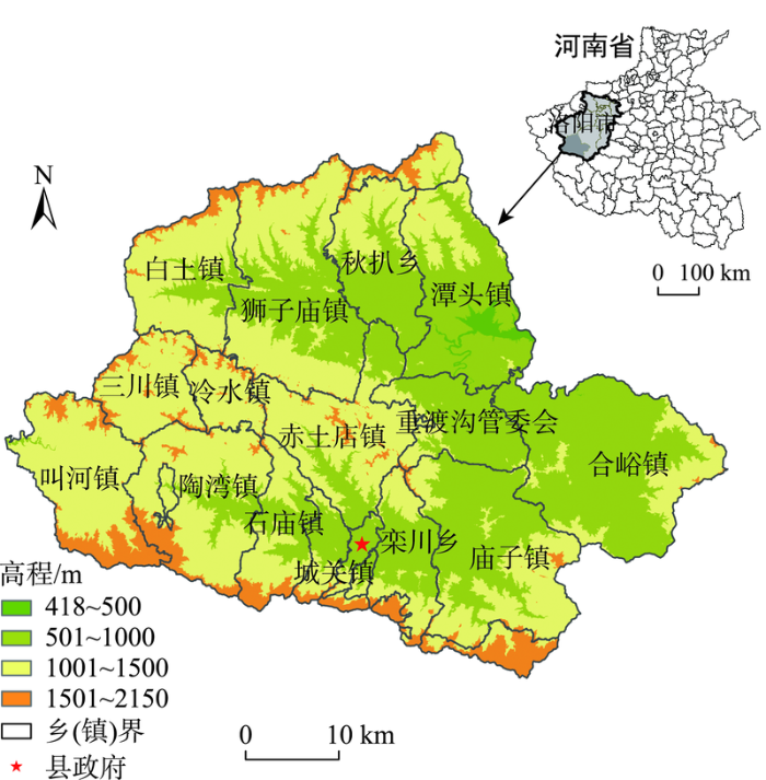
栾川县地处豫西伏牛山腹地,隶属于河南省洛阳市,地理坐标介于111°11′E~112°01′E、33°39′N~ 34°11′N之间,地势西南高、东北低,地貌起伏跌宕,基本地貌素有“四河三山两道川,九山半水半分田”之称(图1)。县域总面积2477 km2,主要交通干线有洛栾高速、三淅高速、省道S249、S328、S322和国道G311,县城距离洛阳市区147 km。2020年底,县域常住人口32.71万人,城镇化率为59.89%,人均生产总值为8.2万元,二三产业占比为94.51%。本文选取栾川县作为典型案例,探讨贫困山区乡村振兴类型识别和振兴路径,依据如下:① 栾川县作为典型山区县,人均耕地面积少,地理位置较为偏远,经济基础较差,属于国家级贫困县,也是秦巴山区国家连片特困地区重点县之一;② 栾川县地形复杂多变且降水量充沛,存在土地侵蚀、矿山复垦等生态环境问题,国土整治和生态修复压力较大;③ 栾川县属于暖温带大陆性气候,年平均气温12.1 ℃,森林覆盖率达到82.4%,居河南省第1位,有“中原肺叶”之称。近年来,该县坚持“绿水青山就是金山银山”的发展理念,通过推动乡村旅游转型升级,初步形成全域旅游格局。鉴于此,以栾川县207个村级单元为研究区域(3个林场不适宜人居住、4个居委会不属于乡村,不作为本文研究对象),综合分析栾川县村庄发展的特征,探讨其村庄乡村振兴的路径和对策。
图1
1.2 数据来源
2020年栾川县行政村普查数据来自于栾川县统计局。各种类型道路数据来源于高德电子地图数据库,包括高速公路、国道、省道和县乡道;幼儿园、小学、初中和卫生院地理分布数据由栾川教育局提供,工商企业数据来自相应年份的天眼查,并根据高德地图进行坐标反查和坐标纠偏。DEM数据来源于ALOS,空间分辨率为12.5 m;土地利用数据来源于2018年栾川县自然资源局第二次土地利用调查更新的地类图斑。
1.3 研究方法
1.3.1 评价指标体系的构建
乡村地域发展受自然条件、资源禀赋、交通区位、社会经济基础等多个方面因素的影响。本文以村域为基本评价单元,以人地关系地域系统理论为指导,考虑到数据的客观性、可获取性和可操作性,参考相关研究,从村庄自然本底、资源禀赋、地理区位、人口发展、经济基础和社会福利6个维度构建村庄多维发展评价指标体系(表1),并采用AHP层次分析和专家打分相结合的方法来确定各个指标的权重,计算出6个维度发展水平。
表1 村域多维发展水平测度指标选择和描述
Tab.1
| 发展维度 | 指标 | 指标含义 | 指标权重 | 功效性 |
|---|---|---|---|---|
| 自然本底 (N) | 15°以上坡度所占比重 | ArcGIS栅格统计 | 0.500 | 逆向指标 |
| 村庄地形起伏度 | 根据封志明等[25]的方法计算 | 0.500 | 逆向指标 | |
| 资源禀赋 (R) | 人均耕地面积 | 村庄耕地面积/村庄常住人口数 | 0.350 | 正向指标 |
| 人均林地面积 | 村庄林地面积/村庄常住人口数 | 0.420 | 正向指标 | |
| 建设用地挖掘潜力 | 村庄建设用地面积/村庄常住人口数 | 0.230 | 正向指标 | |
| 地理区位 (L) | 距县政府远近 | 行政村到最近县政府的时间距离 | 0.350 | 逆向指标 |
| 距镇政府远近 | 行政村到最近镇政府的时间距离 | 0.180 | 逆向指标 | |
| 距干道的距离 | 行政村到国道和省道的时间距离 | 0.300 | 逆向指标 | |
| 距高速口的通达度 | 行政村到最近高速口的时间距离 | 0.170 | 逆向指标 | |
| 人口发展 (P) | 人口聚居程度 | 村庄自然村间的平均距离 | 0.300 | 逆向指标 |
| 人口流失程度 | 1减去村庄常住人口数与户籍人口数之比 | 0.300 | 逆向指标 | |
| 人口规模 | 村庄常住人口数量 | 0.400 | 正向指标 | |
| 经济基础 (E) | 村庄工商企业数 | 行政村内工商企业的个数 | 0.112 | 正向指标 |
| 是否有3A以上景区 | 是=1、否=0 | 0.407 | 正向指标 | |
| 集体经济状况 | 村庄集体收入 | 0.481 | 正向指标 | |
| 社会福利 (S) | 到最近中学的距离 | 行政村到最近中学的时间距离 | 0.197 | 逆向指标 |
| 到最近小学的距离 | 行政村到最近小学的时间距离 | 0.332 | 逆向指标 | |
| 到最近幼儿园的距离 | 行政村到最近幼儿园的时间距离 | 0.139 | 逆向指标 | |
| 到最近卫生院的距离 | 行政村到最近卫生院的时间距离 | 0.332 | 逆向指标 |
自然本底是村庄社会经济发展的基础,包括地形地貌、平地数量等,通过利用地形起伏度、15°以上坡度土地所占比重反映其自然条件的优劣,其中地形起伏度借鉴封志明等[25]所提出的方法计算。资源禀赋则直接影响乡村产业发展的方向及发展的能力,包括耕地、林地和建设用地等土地资源状况,选择人均耕地面积、人均林地面积、建设用地挖掘潜力3个指标来反映村庄资源禀赋的优劣。其中,在耕地保护和生态保护等国土用途管制背景下,现有建设用地存量多少直接影响到乡村可用于旅游休闲等产业发展的用地数量。地理区位体现对主要产品和要素市场的可进入性,包括村庄距离主要城镇和主要交通干线的距离,选取村委会到县政府、镇政府的时间距离来表征村庄的地理区位,同时以村委会到最近国道、省道以及高速口的时间距离来反映村庄与外部联系的交通便捷程度。其中,县城可达性的计算用栾川县面数据15 km的缓冲区,取栾川县各村村委会到栾川县城以及周边的宜阳县、伊川县、汝阳县、南召县、嵩县和洛宁县等7个县城用时最短的时间为该村域的县城可达时间。人口发展反映村庄劳动力资源丰富程度及村庄发展活力,以人口聚居程度、人口流失程度和人口规模来衡量。经济基础反映村庄经济发展现状和经济发展能力,以工商企业数、集体经济状况及村庄是否处于3A以上景区来反映乡村的经济状况。社会福利反映村庄居民生活质量和生活满意度的高低,以村委会到邻近的幼儿园、小学、中学和卫生院等服务设施的时间距离来衡量。时间距离基于栅格数据的时间成本计算[26]。
1.3.2 村域单维发展水平的测度方法
(1) 数据的标准化处理。为消除各个指标的单位和数量级不同所造成的影响,对数据指标进行归一化处理,具体方法如下:
式中:
村庄各维度发展水平测度是在数据标准化处理的基础上,通过指标权重与标准化值相乘求和的方法来测算。计算公式如下:
式中:
1.3.3 多维度发展指数的计算
考虑到分析框架中6个维度间存在不完全可替代关系,选择全排列多边形法,对6个村庄发展维度进行综合集成(图2)。具体计算方法:假设某个村庄的多维发展水平为六边形,6个维度的单项综合得分分别为
图2
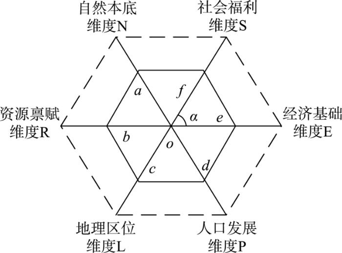
图2
村域多维发展测度框架
注:a、b、c、d、e、f分别表示6个维度的单项综合得分;α表示2个维度之间的夹角。
Fig.2
A measurement framework of multi-dimensional development of villages
因6种单维村庄发展指数以不同排序方式组合的多边形面积也会不同,故选择对6种村庄单维发展指数组成的所有多边形的面积取平均值。由于所有可能组合多边形的面积平均值的大小取决于6种村庄单维发展指数两两相乘后的加总值,故以这一数值作为村域多维发展指数(the dimensional multi-development index,MDI)。
上式能较好地体现6种维度之间的不完全可替代关系,比简单的加权更符合村庄发展测度的衡量。如果某个村庄6种多维评估指标分布更均衡,该式计算后的得分会更大;反之,如果某个村庄的两项指标组成两极分化严重,则得分会大幅降低。
1.3.4 地理探测器模型
地理探测器模型是一种探测某种地理现象空间分异性及其背后驱动力的统计分析方法,包括分异及因子探测、交互作用探测、风险区探测、生态探测4个工具[27]。在本文中,分异及因子探测器用于分析单维发展指数Ls对多维发展指数MDI的决定力大小,进而判断某单维发展指数Ls能多大程度上解释多维发展指数MDI的空间分异;交互作用探测器用于识别不同维度发展指数之间的交互作用,即评估不同发展维度间共同作用时是否会增加或减弱对多维发展指数的解释力,或这些发展维度对多维发展指数的影响是相互独立的。
2 结果分析
2.1 村庄单维度发展得分结果
根据计算出的单维度评价指数,按照自然断裂点将其划分为5种不同类型(图3)。① 自然本底维度得分均值为0.272。由于栾川县平均海拔较高,自然条件较差,以致大部分村庄的自然本底得分值都较低。其中,高值区域主要位于栾川县东部和中南部地区,该地区海拔相对较低、地形起伏度相对平缓,并且平地相对较多;低值区域主要位于栾川县中部和北部地区,该地区大多海拔较高且地形起伏度大,生存条件较为恶劣。② 资源禀赋维度得分均值为0.082。由于栾川县自然条件差,耕地资源较为缺乏,资源禀赋维度分值较低。其中,高值区域主要集中在县域东部的合峪镇和西北部的白土镇,该地区村庄耕地面积丰富,建设用地和林地充足;低值区域主要位于县域西部和西南部,这些村庄地形起伏度大,耕地和林地资源较少,建设用地面积有限。③ 地理区位维度得分的均值为0.840,高值区域主要位于栾川县城和乡镇政府所在地附近以及国道G241沿线,这些区域交通便捷或距离县城较近,地理区位优越;低值则位于县域边界和乡镇交界地带,这些区域到国道省道等主干公路距离较远,且与县城的距离也较远。④ 人口发展维度得分的均值为0.369,集聚特征比较明显,与资源分布格局有相似性。高值区域主要分布在县城附近、东部的合峪镇以及西北部的白土镇,该区域地势平坦且经济基础较好;而低值区域集中分布在县域中部和西南部。⑤ 经济基础维度得分的均值为0.067,得分较高的村庄数量少,主要分布于县域中部、南部乡村政府所在地和各景区所在地,这些地方经济基础好,外来旅游人口较多,为外来人口服务的民宿餐馆等较为发达;低值区域主要位于县域北部,该地区产业基础薄弱,景区开发较少且村庄空心化程度较高。⑥ 社会福利维度得分的均值为0.856,高值区相对均匀分布在各乡镇政府所在地及其附近,由于幼儿园、小学、卫生院等公共服务设施主要分布在城镇,其附近村庄对公共服务设施具有较高的可获得性;低值区则均匀分散在乡镇边界或县域边界,这些地方地理区位偏远,幼儿园、小学、卫生院的可获得程度较低。
图3
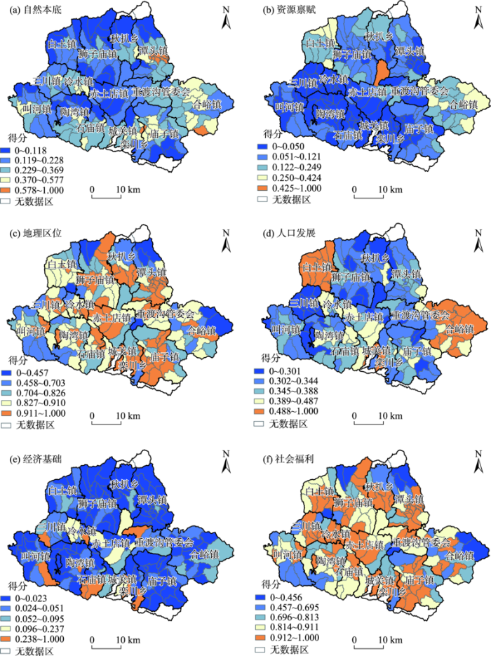
图3
栾川县乡村发展各维度指数的空间分布
Fig.3
Spatial distribution of various dimensions of rural development in Luanchuan County
2.2 村庄发展多维综合评估
根据多边形方法,依据单维度得分计算村庄多维发展指数,并按照自然断裂点法划分为高、较高、中等、较低、低5个等级。结果表明,中等发展水平及以上的村庄占比为45.89%,说明栾川县乡村多维发展水平较低(图4a)。从不同发展水平村庄的空间分布来看,多维发展指数值高的村庄呈现大分散、小集聚的格局。发展水平高的村庄集中分布在县城附近及重点乡镇所在地,由于受到城镇的辐射带动作用,这些村庄家庭有着较多从事非农就业的机会,村庄的空心化率较低。此外,重渡沟、鸡冠洞、老君山等4A以上的景区周边村庄也具有较高的发展水平,主要原因是随着景区开发,这些村庄逐渐成为旅游专业村,为景区发展提供相关服务。近年来,栾川县旅游业发展态势强劲,加上原有资源禀赋的优势和公共服务设施的健全,这些村庄已具有较为坚实的发展基础。多维发展指数值较高的行政村主要集中在主要城镇的周围以及交通干线两侧。多维发展指数值低和较低的村庄则主要分布在县域西部、北部和东部的县域边界附近以及中部乡镇交接区域,这些村庄距离县城或乡镇所在地较远,受到城镇的辐射带动作用较弱,且自然条件比较恶劣,资源禀赋不足,村庄发展受到一定程度的限制。
图4
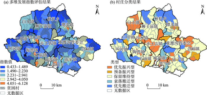
图4
栾川县村庄多维发展指数评估结果及类型划分
Fig.4
Results of multi-dimensional development assessment of villages in Luanchuan County
为分析单维度发展指数与多维发展指数之间的关系,运用地理探测器模型,将自然本底、资源禀赋、地理区位、人口发展、经济基础和社会福利6个维度指数,分别与多维发展指数进行地理探测分析,得到各维度发展指数对多维度发展指数的决定力q,结果表明:对多维发展指数空间分异的决定力大小依次为:自然本底(0.455)、地理区位(0.384)、社会福利(0.358)、人口发展(0.304)、经济基础(0.295)、资源禀赋(0.239)。地理探测器对任意两个单维度发展指数的交互作用分析则表明,任意2个单维度发展指数间的交互作用都存在非线性增强(表2),意味着任何2个单维度发展指数间的交互作用会增加对多维发展指数的解释力。这也进一步验证了基于多边形方法计算多维发展指数的有效性。
表2 各单维度发展指数间交互作用的q值
Tab.2
| 主导交互因子 | q值 | 主导交互因子 | q值 | 主导交互因子 | q值 |
|---|---|---|---|---|---|
| 地理区位∩经济基础 | 0.745 | 经济基础∩人口发展 | 0.619 | 人口发展∩社会福利 | 0.701 |
| 地理区位∩人口发展 | 0.672 | 经济基础∩自然本底 | 0.788 | 人口发展∩资源禀赋 | 0.521 |
| 地理区位∩自然本底 | 0.676 | 经济基础∩社会福利 | 0.768 | 自然本底∩社会福利 | 0.669 |
| 地理区位∩社会福利 | 0.436 | 经济基础∩资源禀赋 | 0.602 | 自然本底∩资源禀赋 | 0.592 |
| 地理区位∩资源禀赋 | 0.616 | 人口发展∩自然本底 | 0.685 | 社会福利∩资源禀赋 | 0.598 |
为进一步分析村庄发展水平与贫困村之间的关系,将精准帮扶贫困村与村庄多维发展水平进行叠加(图4a)。结果表明,栾川县75个精准帮扶贫困村中,有62个贫困村属于低、较低和中等发展水平村庄,占贫困村总数的82.67%。具体而言,9个贫困村属于多维发展低水平村庄,占贫困村总数的12%;32个贫困村属于多维发展较低水平村庄,占贫困村总数的42.67%。这意味着,栾川县精准扶贫战略取得较好的实施成效,部分村庄已具有一定的发展能力。同时,还有很大一部分村庄的可持续发展能力仍然较弱,陷入相对多维贫困的可能性较大,亟需加以关注。
2.3 乡村振兴类型的划分及振兴策略
表3 栾川县乡村振兴类型及政策措施
Tab.3
| 村庄类型 | 村庄个数 | 优势因素组合归类 | 主要特征 | 政策措施 |
|---|---|---|---|---|
| 优先振兴型 | 39 | NLEPS、NLPS、LPES、RLE、RSP、LSP | 多维发展指数分值较高,存在3个及以上的维度发展优势。这些村庄通常位于城镇和景区附近,地理区位好,同时具有自然本底、资源禀赋等方面优势,已具有较好的经济基础,人口集聚能力强 | 推动城镇基础设施和公共服务设施向乡村延伸;充分发挥原有优势,形成不同维度间的协同合力,进一步增强其人口集聚能力和产业承载能力,成为所在区域的增长极和公共服务中心 |
| 预备振兴型 | 16 | LP、RP、ES、NL | 多维发展指数分值较高,存在2个维度发展优势;这些村庄往往位于主要城镇或景区附近,有一定区位优势和经济基础,同时自然本底、资源禀赋较好,人口数量较多 | 找准发展突破点,吸引外部的资金、人才、技术等要素到乡村;在原有优势基础上,充分利用自身的资源禀赋优势,围绕市场需求,大力发展绿色生态农业、民俗旅游等新产业新业态,创新产业经营模式,增强经济实力 |
| 保留维持型 | 113 | PE、NL、NR、NP | 多维发展分值较低,尤其在资源禀赋、社会福利维度得分较低;这些村庄通常资源禀赋状况较差,经济基础较为薄弱,发展潜力较小,人口规模小且流失严重 | 进一步完善教育医疗公共服务设施,整治村庄人居环境,改善村民生产生活条件,增强其幸福感;依托村庄资源,大力发展特色产业,提高其产品附加值,不断提高增加村民收入;可通过合并方式与邻村共同开发以实现发展 |
| 衰落搬迁型 | 14 | L、E | 仅地理区位、经济基础中某个维度有优势,但整体综合发展水平低、发展潜力较小;陷入衰退的恶性循环 | 不适合大规模基础设施和公共服务设施投资;适时对村庄采取异地搬迁,改善村民的生产生活环境 |
| 优先搬迁型 | 25 | — | 任何一个发展维度均不具有优势,生存条件非常恶劣、生态环境脆弱、基础设施和公共服务设施供给水平较低;通过本地投资不能带来社会、经济和生态效益,亟需通过搬迁方式来改善村民的生产和生活环境 | 生态扶贫搬迁、生态宜居搬迁、农村集聚发展搬迁等方式,实现村庄搬迁撤并,改善村民的生产生活环境;通过加强生态保育功能,提升原有村庄生态系统服务价值 |
注:① 发展组合归类中,N、R、L、P、E、S分别代表自然本底、资源禀赋、地理区位、人口发展、经济基础、社会福利;NLEPS表示村庄自然本底、资源禀赋、地理区位、人口发展、经济基础、社会福利同时处于高或较高的水平,其他以此类推。② 发展条件包括地理区位、人口发展、经济基础、社会福利;生存条件包括自然本底和资源禀赋。
2.3.1 优先振兴型
该类型村庄是指3个及以上发展维度为高或较高,同时多维发展指数也处于高或较高水平的区域,包括NLEPS、NLPS、LPES、RLE、RSP、LSP等优势组合类型,占村庄总数的18.84%,主要分布在县城周边、其他主要城镇和旅游景区所在地以及县域东部,其特点是自然条件优越、产业基础好、基础设施和公共服务设施可获得性程度较高,受城镇或旅游景区辐射带动作用明显。由于地理区位和基础设施方面具有先天的优势,并且基于这些先天优势已形成较好的产业基础,教育医疗等社会福利都能得到较好的保障。该类村庄振兴发展可能性最大,是乡村振兴投资的首要区域。在乡村振兴过程中,该类型村庄应坚持城乡融合发展思路,在原有优势基础上突出特点,优化城乡发展空间布局,促进城乡基础设施互通和公共服务设施共享,强化其承接城镇外溢功能的能力。
2.3.2 预备振兴型
该类型村庄是指2个发展维度为高或较高,同时多维发展指数也处于高或较高水平的区域,包括LP、RP、ES、NL等优势组合类型,占村庄总数的7.73%。这些村庄主要位于县城附近、主要城镇附近、县域东部和东南部的潭头镇、合峪镇、庙子镇,其特点是整体发展基础较好,同时在区位交通、公共服务设施、自然本底、资源禀赋等某些方面具有一定的优势。该类村庄具有一定的乡村振兴可能,是乡村振兴投资的次选区域。在乡村振兴过程中,这些村庄亟需机制体制的创新,吸引更多的资本、技术和人才等要素参与到村庄发展过程中,结合自身现有资源优势和区位优势,大力发展特色种植业和养殖业,有条件的地方依托特色农业资源和山水资源,发展乡村旅游。通过激发乡村发展的潜力和活力,将原本薄弱的产业基底发展壮大。
2.3.3 保留维持型
该类型村庄是指有2个维度的发展指数处于较高以上水平,同时多维发展维度得分中等或较低的区域,包括PE、NL、NR、NP等优势组合类型,占村庄总数的54.59%。该类型村庄数量最多,分布范围也最广,基本覆盖整个县域。该类型村庄在自然本底、资源禀赋、地理区位、人口发展、经济基础等某些方面具有一定优势,但整体发展水平和发展潜力不高。该类型村庄存在2种情形:① 少数村庄通过抓住机遇,从外部引入资金、技术和人才等要素,结合自身现有优势,激发自身发展的潜力和活力,大力发展特色种植业和养殖业,有条件的地方依托特色农业资源和山水资源,发展乡村旅游,有可能实现振兴;② 绝大多数村庄因为产业基础较为薄弱、整体的经济总量较低,人口持续流出,逐步演变为衰退搬迁型村庄。该类型村庄的发展策略是通过进一步完善基础设施和优化公共服务,改善村庄的人居环境,使得留守村民能享受基本的基础设施和公共服务。该类型村庄发展条件和发展基础均难以达到乡村振兴要求,实现振兴可能较低。
2.3.4 衰退搬迁型
该类型是指仅有1个维度发展指数处于较高以上水平,同时多维发展指数较低或低的村庄,包括仅有L、E等单一维度优势的村庄,占村庄总数的6.76%。该类型主要分布在县域内乡镇边界处,其特点在地理区位、经济基础等某个方面具有一定优势,但整体发展条件不足、发展基础较为薄弱。由于村庄存在资源禀赋较差、产业发展滞后、地理区位偏远、服务设施可获得性较低等多个方面的不足,导致其经济发展水平较低,人口流失严重,处于不断衰退中。在乡村振兴过程中,该类型村庄不适合大规模基础设施和公共服务设施投资,适宜采取发展特色种植、旅游开发等方式,改善居民的生计资本。随着人口的进一步减少和地方政府具备一定经济实力之后,村庄整体搬迁到其他地方。
2.3.5 优先搬迁型
该类型是指没有任何单一维度发展指数处于较高以上水平,同时多维发展指数也较低或低的村庄,占村庄总数的12.08%。这些村庄主要分布在北部和西部的县域交界处以及中部少数乡镇交界处,其特点是自然条件较差、资源禀赋不足、地理位置偏远、人口流失严重等,多个方面存在不足,同时缺少相应的产业支撑、基础设施和公共服务,不具备乡村振兴发展的自然基础。在乡村振兴过程中,可通过生态扶贫搬迁、生态宜居搬迁、农村集聚发展搬迁等方式,实现村庄搬迁撤并,统筹解决村民生计、生态环保等问题。同时,原有村庄可通过加强生态保育功能,提升其生态系统服务价值。
3 结论与讨论
乡村发展类型识别和振兴路径研究是乡村振兴战略落地实施的重要基础。本文融合多源数据,从自然本底、资源禀赋、地理区位、人口发展、经济基础和社会福利6个维度构建村庄多维发展评价指标体系,对案例区村庄多维发展水平进行评估。在此基础上,对村庄多维发展水平的空间分异特征及其主导因素进行识别和类型划分,进而提出不同类型乡村振兴发展的策略。主要结论如下:
(1) 基于多边形方法构建的指标体系能较为科学精准地评估村庄发展状况。根据多维发展指数计算和分类结果,中等及以上多维发展潜力村庄数量占比为45.89%,表明栾川县乡村多维发展潜力总体情况不容乐观。虽然精准扶贫战略实施成效明显,少数贫困村已具有一定的发展能力,但大多数村庄陷入相对多维贫困的可能性仍然较大。
(2) 多维发展水平空间分异特征较为明显。多维发展指数高的村庄集中分布在县城附近及重点乡镇所在地,发展水平较高的行政村主要集中在主要城镇的周围以及交通干线两侧。多维发展指数低和较低的村庄则主要分布在县域西部、北部和东部的县域边界附近以及中部乡镇交接区域。基于地理探测器的分析表明,多维发展指数空间分异的决定力大小依次为:自然本底、地理区位、社会福利、人口发展、经济基础、资源禀赋。任意2个单维度发展指数间的交互作用都存在非线性增强。这进一步验证了基于多边形方法计算多维发展指数的有效性。
(3) 单维度发展的结果分析表明,单维度发展水平均呈现较为显著的集聚分布特征,但不同维度间空间集聚格局具有差异。其中,地理区位和自然本底发展水平较高的村庄主要分布在资源禀赋好、地势较为平坦的地区,发展水平较低的村庄则主要分布在地形起伏度大、生存条件较为恶劣的地区;地理区位、人口发展、经济基础和社会福利4个维度发展水平较高的村庄主要分布在县城、乡镇政府所在地和旅游景区附近,发展水平较低的村庄则主要分布在乡镇交界或县域边界。
(4) 根据多维发展指数的测算结果和主导因素,将贫困山区乡村划分为优先振兴型、预备振兴型、保留维持型、衰退搬迁型和优先搬迁型5种不同类型。乡村振兴并非对现存所有村庄都进行振兴,也不是对所有村庄同步振兴。尤其是贫困山区在人力、财力和物力等资源要素都十分有限的情况下,更应将有限资源投入到真正需要的地方。在乡村振兴过程中,应根据县域所处发展阶段,结合不同类型村庄的优势组合和限制因素进行分类施策,破解城乡发展不平衡和乡村发展不充分问题。其中,优先振兴型和预备振兴型应重点关注人口和产业集聚能力的提升,保留维持型、衰退型和优先搬迁型则应重点关注现有人居环境的改善和基本公共服务的供给。
科学分类村庄是实施乡村振兴战略的关键环节。本文以河南省栾川县为例,尝试融合行政村普查、电子地图POI等多源数据,结合贫困山区实际从自然本底、资源禀赋等6个维度构建村庄多维发展评价指标体系,对村庄发展水平进行评估和类型识别,所提出的方法对贫困山区县域乡村振兴战略的制定和实施具有重要的参考价值。同时弥补了以往研究基于调查数据对少数村庄进行分类研究的不足,实现县域村庄多维发展水平评估全覆盖。但同时,也有需要进一步完善的地方:① 考虑到行政村统计调查数据具有一定统计偏误,未来研究将整合手机信令数据、家庭用电数据等其他大数据,增强其互补性,进一步完善村庄多维发展评估指标体系;② 结合典型案例的调研,弄清不同类型村庄振兴发展的深层机理,为乡村振兴路径的设计提供科学依据。
参考文献
中国新时代城乡融合与乡村振兴
[J].
DOI:10.11821/dlxb201804004
[本文引用: 1]

城市与乡村是一个有机体,只有二者可持续发展,才能相互支撑。依据人地关系地域系统学说,城乡融合系统、乡村地域系统是全新认知和理解城乡关系的理论依据。针对日益严峻的“乡村病”问题,全面实施乡村振兴,既是推进城乡融合与乡村持续发展的重大战略,也是破解“三农”问题,决胜全面建成小康社会的必然要求。本文探讨了新时代城乡融合与乡村振兴的基础理论,剖析了乡村发展面临的主要问题,提出了问题导向的中国城乡融合与乡村振兴科学途径及研究前沿领域。结果表明:① 城乡融合与乡村振兴的对象是一个乡村地域多体系统,包括城乡融合体、乡村综合体、村镇有机体、居业协同体,乡村振兴重在推进城乡融合系统优化重构,加快建设城乡基础网、乡村发展区、村镇空间场、乡村振兴极等所构成的多级目标体系。② 中国“三农”问题本质上是一个乡村地域系统可持续发展问题,当前乡村发展正面临主要农业生产要素高速非农化、农村社会主体过快老弱化、村庄建设用地日益空废化、农村水土环境严重污损化和乡村贫困片区深度贫困化等“五化”难题。③ 乡村是经济社会发展的重要基础,城乡融合与乡村振兴战略相辅相成,乡村振兴应致力于创建城乡融合体制机制,推进乡村极化发展,按照产业兴旺、生态宜居、乡风文明、治理有效、生活富裕的要求,构建乡村地域系统转型—重构—创新发展综合体系。④ 乡村振兴地理学研究应着眼于乡村地域系统的复杂性、综合性、动态性,探究以根治“乡村病”为导向的新型村镇建设方案、模式和科学途径,为实现新时代中国乡村振兴战略提供理论参考。
Research on the urban-rural integration and rural revitalization in the new era in China
DOI:10.11821/dlxb201804004
[本文引用: 1]
Cities and villages are components of a specific organism. Only the sustainable development of two parts can support the prosperous development as a whole. According to the theory of man-earth areal system, urban-rural integrated system and rural regional system are the theoretical bases for entirely recognizing and understanding urban-rural relationship. To handle the increasingly severe problems of "rural disease" in rapid urbanization, accelerating rural revitalization in an all-round way is not only a major strategic plan for promoting the urban-rural integration and rural sustainable development, but also a necessary requirement for solving the issues related to agriculture, rural areas, and rural people in the new era and securing a decisive victory in building a moderately prosperous society in all respects. This study explores the basic theories of urban-rural integration and rural revitalization and analyzes the main problems and causes of rural development in the new era, proposing problem-oriented scientific approaches and frontier research fields of urban-rural integration and rural revitalization in China. Results show that the objects of urban-rural integration and rural revitalization is a regional multi-body system, which mainly includes urban-rural integration, rural complex, village-town organism, and housing-industry symbiosis. Rural revitalization focuses on promoting the reconstruction of urban-rural integration system and constructs a multi-level goal system including urban-rural infrastructure networks, zones of rural development, fields of village-town space and poles of rural revitalization. Currently, the rural development is facing the five problems: high-speed non-agricultural transformation of agriculture production factors, over-fast aging and weakening of rural subjects, increasingly hollowing and abandoning of rural construction land, severe fouling of rural soil and water environment and deep pauperization of rural poverty-stricken areas. The countryside is an important basis for the socioeconomic development in China, and the strategies of urban-rural integration and rural revitalization are complementary. The rural revitalization focuses on establishing the institutional mechanism for integrated urban-rural development and constructs the comprehensive development system of rural regional system, which includes transformation, reconstruction and innovation in accordance with the requirements of thriving businesses, pleasant living environments, social etiquette and civility, effective governance, and prosperity. Geographical research on rural revitalization should focus on the complexity and dynamics of rural regional system and explore new schemes, models and scientific approaches for the construction of villages and towns, which are guided by radical cure of "rural disease", implement the strategy of rural revitalization polarization, construct the evaluation index system and planning system of rural revitalization, thus providing advanced theoretical references for realizing the revitalization of China's rural areas in the new era.
农村地区收入差异与人力资本积累
[J].
The income gap and the accumulation of human capital in rural China
An index of rurality for England and Wales
[J].DOI:10.1080/09595237700185041 URL [本文引用: 1]
New assessment of development status among the people living in rural areas: An alternative approach for rural vitality
[J].DOI:10.47743/saeb-2019-0013 URL [本文引用: 1]
The evaluation of rural competitiveness in creating a policy of rural development in Croatia
[J].
Application of the rural development index to analysis of rural regions in Poland and Slovakia
[J].DOI:10.1007/s11205-010-9765-6 URL [本文引用: 1]
基于夜间灯光数据的中国多维贫困空间识别
[J].
Spatial identification of multidimensional poverty in China based on nighttime light remote sensing data
乡村地域多功能空间分异特征及类型识别: 以辽宁省78个区县为例
[J].
DOI:10.11821/dlyj020170647
[本文引用: 1]
以具有国家粮食基地和老工业基地的经济功能与特征的辽宁省为例,通过构建乡村地域多功能评价指标体系,采用ArcGIS自然间断点分级法和全局空间自相关分析农业生产、非农生产、居住生活和生态保障四类功能的空间格局特征,采用Spearman等级相关系数定量分析功能间交互作用,识别各区县优势功能类型,并提出未来发展的政策建议。结果表明:① 从省域层面看,乡村地域功能空间格局的空间差异性和空间集聚特征显著;② 根据乡村地域功能间的相关关系和功能间的互动实际,得出各功能间的交互作用类型,从而为功能调控提供指导;③ 基于功能状态和功能间的交互作用,将辽宁省78个区县划分为8种乡村地域功能类型,并根据类型提出科学谋划辽宁乡村未来发展的初步建议,为促进乡村转型与城乡统筹提供参考。
Spatial differentiation and type identification of rural territorial multi-functions in Liaoning Province
DOI:10.11821/dlyj020170647
[本文引用: 1]
In the new era, China is promoting integrated urban and rural areas. Rural territory is in the process of transformation, development and reconstruction. The features of rural territorial function diversification and multi-functionality have become more and more obvious. This paper takes Liaoning province, which is one of the national grain producing bases and old industrial bases in China, as the research area. It constructs an evaluation index system of rural territorial multifunctions from the following four aspects: agricultural production function, non-agricultural production function, dwelling and living function, and ecological service function. Jenks and Global Spatial Autocorrelation are used to explore the spatial pattern and spatial correlation of rural territorial functions. The Spearman's rho is used to analyze the interactions among rural territorial functions. This paper identifies the dominant function types of different counties in Liaoning province, and puts forward policy recommendations for their future development. The results of the study are reflected in the following three aspects: (1) The spatial distribution of rural territorial functions has obvious spatial heterogeneity and spatial agglomeration characteristics in Liaoning province. The highest and higher values of agricultural production function concentrate in the Liaohe River Plain. Non-agricultural production function decreases from the core urban areas, the highest, and higher values areas to the outside. The highest, higher, and middle values of dwelling and living function concentrate in municipal districts. The highest and higher values of ecological service function are observed in the mountainous areas. (2) According to the correlation among rural territorial functions and the actual interaction among functions, the types of interaction among functions have been clearly identified, which can provide guidance for the regulation of functions. (3) Based on the status and interactions of different functions, eight types of rural territorial functions have been identified. According to the types, preliminary proposals are put forward for the future development of rural areas in Liaoning province, which would provide references for the promotion of the rural transformation and the balanced urban and rural development.
江苏省乡村地域功能与振兴路径选择研究
[J].
DOI:10.11821/dlyj020180919
[本文引用: 1]
乡村振兴战略背景下,探索乡村振兴的差异化路径成为研究热点。乡村地域功能具有空间的差异性,明晰乡村地域功能的空间格局对于准确定位乡村发展模式、实施差异化的乡村振兴路径具有重要意义。本文以江苏省为例,采用定量评价方法,构建了包含生产发展、生活保障和生态保育为核心的乡村地域多维功能评价指标体系,以县级尺度识别了乡村地域功能的空间格局和地域类型,在此基础上探索各类型区差异化的乡村振兴路径。结果表明:江苏省乡村生产发展功能尚需完善、空间集聚程度低;生活保障功能空间格局和社会经济发展的地带性规律基本一致,呈现由苏南向苏北渐进衰退的趋势;生态保育功能高值区的区县数量较少,大部分区县的生态保育功能还有待加强;乡村地域总体功能由苏南向苏北呈现先行发展区、优化升级区、转型提升区和滞后欠发达区四种地域类型。此外,根据乡村地域总体功能呈现的差异化地域类型分别提出了相应的乡村振兴路径。
Detecting the pathways towards rural vitalization from the perspective of territorial functions in Jiangsu Province
DOI:10.11821/dlyj020180919
[本文引用: 1]
Detecting a pathway towards rural vitalization has drawn considerable attentions from both governments and scholars in China within the context of rural restructuring. Given that territorial functions of rural areas varies cross the country, it is essential to clarify the spatial pattern of territorial functions for demystifying the model and pathway of rural development. Taking Jiangsu - one of the most developed provinces in eastern China - as an example, this paper proposes an indicator system for rural territorial function covering triple dimensions of economic development, life support, and ecological conservation. Thereafter, we conduct an empirical study at the county and district level followed by a discussion about potential pathways towards the vitalization of villages in different zones. The findings imply that: 1) the function of economic development in rural Jiangsu is not as good as expected, and the degree of spatial agglomeration is relatively low. Coincidently, the pattern of life support is consistent with that of economic development, which is regarded as a trend of gradual decline from south to north. Few districts or counties can be detected with high values of ecological conservation, which suggests an urgent demand for sustainable development in rural Jiangsu. 2) Taking the spatial heterogeneity of rural areas in respect of their overall functions into consideration, we further divide the province into four zones, namely primarily developed zone, optimized developing zone, transformation zone, and lagging underdeveloped zone. Finally, we put forward some suggestions for rural vitalization in the aforementioned functional zones, and argue that rural revitalization is a long-term project that cannot be done overnight.
中国重点农区乡村地域功能演变及其影响机理: 以江汉平原为例
[J].
DOI:10.18306/dlkxjz.2020.01.006
[本文引用: 1]
乡村振兴战略的实施亟需提炼不同乡村地域类型的发展路径。论文构建了乡村地域生产、生活、生态功能测度指标体系,刻画江汉平原乡村地域功能演化特征;基于空间计量模型探析了江汉平原乡村地域功能演变的影响因素及作用机理。研究结果发现:① 江汉平原各县域乡村地域功能指数均呈现出不同程度的增长趋势,生产、生活、生态功能指数分别增长78.26%、34.25%、9.68%;生产功能增长主导和生活功能增长主导是乡村地域综合功能提升的主要类型。② 江汉平原乡村地域功能存在显著的空间非均衡分布格局,生态功能主导型县域主要分布于北部边缘地区,生活功能主导型县域集中分布于中部和南部地区,生产功能主导型县域分布相对零散;生态功能和生活功能主导江汉平原乡村地域功能的空间变化。③ 外源驱动对江汉平原乡村地域功能变化主要表现为负向作用,内生响应主要表现为正向作用;乡村生产功能受外源驱动和内生响应的影响程度最高,乡村地域综合功能被影响程度次于乡村生产和生活功能;乡村地域综合功能和生产、生活功能具有正向的空间溢出效应。探寻农产品主产区乡村地域功能演变的影响因素及作用机理,有助于识别差异化的乡村发展路径,为乡村振兴战略实施提供参考依据。
Change and mechanism of influence of rural territorial functions in major agricultural areas of China: A case study of the Jianghan Plain
DOI:10.18306/dlkxjz.2020.01.006
[本文引用: 1]
The identification of rural territorial functions of major agricultural areas can provide an important support for rural revitalization and food security. The Jianghan Plain is one of the main agricultural areas in China and is undergoing a rapid rural transformation and reconstruction. From the perspective of ecological, production, and living spaces, this study constructed an indicator system for the assessment of production, living, and ecological functions of rural areas. Using the entropy weight method to determine the weights of indicators, we examined the pattern of change of rural territorial functions in the rural areas of the Jianghan Plain from 2000 to 2015. The influencing mechanism of change was analyzed by applying spatial econometric models. The results show that: 1) The total index value of rural territorial functions of the rural area in the Jianghan Plain increased notably. Values of the three sub-index of production, living, and ecological functions increased by 78.26%, 34.25%, and 9.69%. Growths in the production function and living function were the two main ways of rural function improvement in the Jianghan Plain. 2) The rural function index values of the Jianghan Plain showed prominent spatial differentiation, with an overall east-west divide. Specifically, counties dominated by ecological function mostly aggregated on the northern fringe of the Jianghan Plain, while those dominated by living function aggregated on the central and southern part of the Jianghan Plain, and those dominated by production function showed a random spatial distribution. Ecological function and living function played a major part in the change of rural functions in the Jianghan Plain. 3) We argue that the factors that affect rural development can be divided into two types, namely exogenous driving forces and endogenous responses. The results of the spatial econometric models indicate that both types have an impact on the change in rural territorial functions in the Jianghan Plain. More specifically, the exogenous factors showed a positive influence on the change of rural function in the Jianghan Plain, while the endogenous factors showed a negative effect. The greatest impacts of both the exogenous and the endogenous factors were on production function, followed by living function and total function. The marketization response had spatial spillover effects on the change of rural territorial functions of the Jianghan Plain. Our findings indicate that developing multifunctional agriculture in the Jianghan Plain is a rational choice. In practice, exploring change and influencing mechanism of rural territorial functions for major agricultural areas, on the one hand will be helpful for identifying different patterns of rural development and providing guidance for the implementation of rural revitalization. On the other hand, research on functional types of rural areas could have a broad impact on rural development and urban and rural coordination. Due to the differences in major territorial functions and external conditions, we suggest that the applicability of the evaluation index system and influencing mechanism should vary along with the territorial types.
黄土高原乡村体制转换与转型发展
[J].
DOI:10.11821/dlxb202002010
[本文引用: 1]
农户生计方式的改变对研究黄土高原乡村转型发展具有重要意义。以黄土高原苹果优生区的彬县、长武县和旬邑县为研究区,从体制转换的视角出发,基于模糊层次分析、地理探测器和多元线性回归等算法,模拟乡村体制演化的路径,甄别影响乡村转型发展的微观要素,进一步揭示农户家庭体制转换与乡村转型发展之间的互馈机理。研究发现:① 在研究区内抽样选择的130个乡村中,传统农业体制型乡村共有27个,主要分布于黄土梁地貌类型区,新型农业体制型乡村共有96个,主要分布于黄土塬地貌类型区,非农体制型乡村共有7个,主要分布于河谷地貌类型区;② 当乡村地域系统由传统农业型体制向新型农业型体制转变,再至非农型体制的演化路径中,乡村转型发展度在三维空间坐标系中为倒“U”型变化趋势,乡村人口发展度在二维坐标系中表现为下凸递增趋势,乡村经济发展度在二维坐标系中表现为上凸递增趋势,农业经济发展度在二维坐标系中表现为倒“U”型发展趋势;③ 生计方式成为衔接农户家庭体制转换与乡村转型发展的控制性因素,在农户尺度上,由人力资本与自然资本决定,并直接影响到金融资本和物质资本,在村域尺度上,通过与乡村地域系统的人口、经济和农业等3个维度的响应,引导乡村转型发展过程。
Rural regime shifts and transformation development on the Loess Plateau
DOI:10.11821/dlxb202002010
[本文引用: 1]
It is important to study rural transformation and development from the perspective of farmers' livelihood regime changes on the Loess Plateau. We selected cunties of Binxian, Changwu and Xunyi located in the apple growing area of the Loess Plateau, as a case study to construct the evolutionary path of rural regime, identify the micro factors that affect rural transformation and development, and reveal the mutual feedback mechanism between farmers' household regime and rural transformation. In doing so we adopted a regime change perspective, and applied the fuzzy analytic hierarchy process method, geodetector, and multiple linear regression. We obtained the following three findings. First, 27 of 130 selected samples, distributed mainly in areas with loess girder topography, belonged to the traditional agricultural regime. Meanwhile, 96 samples, distributed mainly in areas with loess tableland topography, belonged to the new agricultural regime. Another 7 samples, mainly distributed in valley areas, belonged to the non-agricultural regime. Second, when rural transformation sees the traditional agricultural regime replaced by the new agricultural regime, and finally the non-agricultural regime, the overall performance of rural development follows an inverted U-type development trend in a 3D space coordinate system. Simultaneously, rural population development follows an upward convex development trend in a 2D space coordinate system. Meanwhile, rural economic development follows an upward concave development trend, and agricultural production development follows an inverted U-type development trend, both in 2D space coordinate systems. Third, means of livelihood is the control variable that connects family system transformation and rural transformation development, which are determined by human and natural capital and directly affect financial and material capital at the farmer level. These aspects of transformation development are guided by the response process at the village level of three dimensions, namely population, economy and agriculture, and lead the process of rural transformation and development.
集中连片特殊困难地区村域空间贫困测度指标体系研究
[J].
DOI:10.13249/j.cnki.sgs.2014.04.447
[本文引用: 1]
在阐述多维贫困和空间贫困概念内涵及其指标基础上,提出了集中连片特殊困难地区村域空间贫困测度指标体系构建的基本原则,即强调科学性和主导性原则、重视数据的可获得性和测度的可操作性、体现减贫与反贫困的新要求、突出区域性和空间刻画能力。据此,构建了包括经济、社会、环境和政策4个维度,收入和消费、市场连通性、人口状况、学有所教、病有所医、老有所养、住有所居、劳有所得、地貌要素、自然灾害、生态安全、农业生态、粮食安全和政策的实效性共13个指标组,27个原始指标或生成指标构成的集中连片特殊困难地区村域空间贫困测度指标体系。进一步讨论了空间贫困测度指标的检验、获取方法和空间化等关键问题。
The index system of spatial poverty of village level to monitor in concentrated contiguous areas with particular difficulties
DOI:10.13249/j.cnki.sgs.2014.04.447
[本文引用: 1]
On the basis of the exposition about concept connotations and indexes between multidimensional poverty and spatial poverty, basic principles contributing to constructing index system of spatial poverty to monitor in concentrated contiguous areas with particular difficulties were put forward, which are, scientific and dominant principles, the availability of data and the operability of the measurement, embodiment of new requirements on poverty and anti-poverty, emphasis on regional characters and ability of characterizing space. Furthermore, index system of spatial poverty to monitor in concentrated contiguous areas with particular difficulties which is consisting of four dimensions (economy, society, environment and policy), thirteen index groups, for example, income and consumption, market connectivity, demographic situation, education, employment, medical services, a sense of security, housing condition, geomorphic elements, natural hazards, ecological security, agro-ecology, food security, policy effectiveness, was constructed according to the principles above. The index system was totally comprised of twenty-seven initial or generated indicators. Moreover, the key issues such as verification, acquisition methods, spatialization of spatial poverty index system and so on were discussed then.
西北贫困地区乡村类型识别与振兴途径研究
[J].
DOI:10.11821/dlyj020181230
[本文引用: 1]
乡村振兴战略是新时期我国推进城乡融合发展的重要举措。贫困地区既是脱贫攻坚的主战场,又是乡村振兴的重点区域。如何科学识别村落类型,分类推进典型区域乡村振兴发展,对于破解农村发展不平衡不充分问题具有重要的现实意义。本文解析了乡村地域系统发展理论,阐释了城乡融合发展理论,剖析了村域空间结构格局演变和城乡要素结构功能优化重组;构建了西北干旱贫困地区乡村振兴村落类型识别体系,从乡村主体、产业发展、人居环境、资源禀赋4个子系统进行逐级分类判断,识别乡村主导类型,结合专家征询分析与村落特征,将乡村振兴村落类型识别为集聚提升类、三产融合类、城郊融合类、特色保护类、搬迁撤并类,结合不同乡村振兴模式提出了相应地发展路径,以期为乡村振兴提供理论依据与决策参考。
Identification and revitalization of rural poverty-stricken areas in Northwest China
DOI:10.11821/dlyj020181230
[本文引用: 1]
The rural revitalization strategy is an undertaking in China to advance urban and rural integration. China is an agricultural country with a large but poor rural population. At the village level, the rural revitalization strategy has the potential to alleviate poverty and affect millions of citizens. Poverty-stricken areas are a composite of fragile ecological environments and rural impoverished communities. Beyond that, they are also major battlefields for poverty elimination as well as crucial regions for rural revitalization. How to scientifically identify the different types of rural areas and promote rural revitalization of typical areas will be of significant importance for resolving problems such as unbalanced, inadequate rural development. This study features Tongxin, which is a poverty-stricken county located in northwest China, and relies on an approach including a comprehensive evaluation method to measure rural development level, using technology to identify village type as well as expert consultation method analysis. At the same time, this paper proposes a theory of a rural regional system, elaborates on the urban-rural integrative development theory, and analyzes the structural framework evolution of rural spaces as well as the reconstruction and optimization of the structural function of urban and rural areas. It formulates an identification system for the rural poverty-stricken areas in northwest China, which are to be revitalized; to do so, it makes classifications and determinations through four sub-systems (rural subject, industry development, living environment, and resources) so as to identify the rural type. In combination with consultation and analysis from experts, as well as consideration of the rural features, the rural areas to be revitalized are classified into different types: agglomeration for improvement, mixing three industries, urban-suburban integration, protection due to its special nature, relocation and merging. In combination with different modes of rural revitalization, corresponding development methods are proposed accordingly, so as to provide theoretical evidence and decision references for new urbanization and urban-rural integration strategies in addition to the rural revitalization strategy.
迈向2035年的中国乡村: 愿景、挑战与策略
[J].
China's rural areas toward 2035: Vision, challenges and strategies
乡村振兴的学术脉络与时代逻辑: 一个经济学视角
[J].
The academic context and logic of rural revitalization: An economic perspective
准确把握中国乡村振兴战略
[J].
On the strategy of rural revitalization in China
全面推进乡村振兴: 权威专家深度解读十九届五中全会精神
[J].
Comprehensively promote rural revitalization: authoritative experts deeply interpret the spirit of the Fifth Plenary Session of the 19th CPC Central Committee
村庄布点规划方法探讨
[J].
Planning method for village allocation
城乡一体化背景下苏州村镇公共服务设施配置研究
[J].
Configuration of the public service facilities in Suzhou rural area on the background of the urban and rural integration
湖南省传统农区乡村功能时空演变及影响因素研究
[J].
DOI:10.13249/j.cnki.sgs.2021.12.010
[本文引用: 1]
乡村是城市功能扩散与转移的重要承接地,乡村功能的时空演变及影响因素分析对实现城乡统筹发展与可持续发展具有重要意义。综合运用熵值法、冷热点分析和地理探测器等方法,以湖南省102个县市为研究对象,对湖南省乡村功能的时空演变、空间分异及其影响因素进行研究。结果表明:① 1997―2017年县域乡村生产和生活功能整体上呈现出上升的发展态势,而乡村生态功能整体上呈减弱的趋势。② 1997―2017年湖南省乡村功能热点区由长株潭地区向外扩张,而冷点区呈先收缩后扩张的发展态势;20 a间,在长株潭地区形成稳定的热点区,在湘西地区形成稳定的冷点区。③ 湖南省乡村功能空间分异是农业现代化、乡村就业主体、县域经济基础、城镇化、工业化等综合作用的结果,其影响力大小与方向存在显著的差异性,其中农业现代化水平、乡村就业主体对湖南省及5个地区乡村功能空间分异有重要的驱动作用。
The spatial-temporal evolution and influencing factors of rural functions in traditional agricultural areas in Hunan Province
DOI:10.13249/j.cnki.sgs.2021.12.010
[本文引用: 1]
Rural function refers to the sum of various services provided by the village to meet the various needs of rural residents, involving ecological, economic, social, cultural and other aspects. China is in a critical period of urbanization development. The expansion of urban and rural construction land has restricted rural production space, fragmented living space, and unbalanced ecological space. However, the development of economy and technology and the proposal of rural revitalization strategies have prompted the reintegration of various elements of the rural regional system. The village has entered a period of rapid transformation. Under the effects of both rural revitalization and urbanization, important changes have taken place in rural employment structure, consumption patterns, and urban-rural relations. Rural functions have gradually extended from primitive residential and agricultural production functions to industrial production functions, life support functions, and eco-tourism. Traditional agricultural areas are the main producing areas of agricultural products and agricultural and sideline products, and shoulder the important task of national food security. The occupation of cultivated land by industrialization and urbanization has affected the development of traditional agricultural areas in the country. The priority development of China’s economic efficiency has neglected the protection of rural culture and ecology, which has caused serious degradation of rural traditional functions. The village is an important bearing of the diffusion and transfer of urban functions. The analysis of the spatiotemporal evolution of rural functions and its influencing factors is of great significance for the realization of urban and rural integrated development and sustainable development. A comprehensive application of the entropy method, cold and hot spot analysis, and geo-detector methods, taking 102 counties and cities in Hunan Province as the study area, the spatial-temporal evolution, spatial differentiation, and driving forces of rural functions in Hunan Province are studied by the paper. The results show that: 1) On the whole, from 1997 to 2017, the production and living functions of rural areas in the county area showed an upward trend, while changes in rural ecological functions showed a weakening development trend. 2) From 1997 to 2017, Hunan’s rural functional hotspot area expanded from Changzhutan area to the periphery, while the cold spot area expanded first and then expanded. In these 20 years, a stable hotspot area was formed in Changzhutan area, while On the west side, a stable cold spot area is formed. 3) The spatial differentiation of rural functions in Hunan Province is the result of the combined effect of county background factors and external driving factors, and their roles are significantly different in direction and direction. The two indicators of agricultural modernization level and the main body of rural employment have a significant impact on rural functions.
共生与融合: 乡村遗产地“人—地—业”协同发展研究: 以听松文化社区为例
[J].
DOI:10.18306/dlkxjz.2022.04.004
[本文引用: 1]
经过5000年文化积淀的中国乡村,除早已生成各自独特稳定的人居环境、社会结构、风俗习惯和运行机制外,更蕴藏了人—地和谐的生态智慧、特殊的地方性知识和丰富的地方遗产资源。作为复杂多元的地域综合系统,乡村遗产的现代化过程不仅包括土地、建筑等空间要素的嬗变,更反映了伴随“人”的生计方式与日常生活的地方实践所产生的乡土社会全系统变迁。实现乡村遗产传统与现代的共生、古典与时尚的互融、传承与创新的契合,需要打破城乡二元体制壁垒、搭建城乡内循环的桥梁,促进以“人、地、业”为核心的资源要素的流动、交互和均衡配置是乡村遗产地实现乡村振兴的核心要义。共生理论是研究乡村各系统内部关系的重要理论,利用该理论可解析乡村遗产地“人—地—业”3个子系统协同发展路径。论文以河北易县听松文化社区为例,基于共生视角阐释了返乡精英带动下人口、土地和产业3个子系统协同动态演化的过程,并提出乡村遗产地共生发展的价值逻辑:① 构建乡村社区共生体;② 促进地域循环共生圈;③ 培育横向产业共生链。以期实现乡村遗产地的人、地、业要素融合与科学重构,为保护和传承乡愁遗产地的文化资源、推动乡村振兴和建设美好乡村提供可能的理论启示与经验借鉴。
Symbiosis and integration: Coordinated development of human-land-industry in rural heritage sites: A case study of the Tingsong cultural community
DOI:10.18306/dlkxjz.2022.04.004
[本文引用: 1]
Many rural heritage sites in China are rich in natural and cultural tourism resources. The co-creation of landscape resources, co-ownership of territorial space, and diverse ethnicities and rural social relationship provide the basis and conditions for the symbiosis development of tourism. In addition, as an open system with comprehensive multidimensional and dynamic evolution, rural heritage sites are formed by the interaction of various elements. Population, land, and industry are the core elements of rural development. Symbiosis theory is an important theory for studying the internal relationships of rural systems, which can be used to analyze the coordinated development paths of human-land-industry subsystems in rural heritage sites. Taking Tingsong cultural community in Yi County, Hebei Province as an example, this study examined the collaborative dynamic evolution process of the three subsystems of population, land, and industry driven by the returning elite from the perspective of symbiosis, and put forward the symbiotic paths of rural development: 1) Building the symbiont of rural community. 2) Promoting the regional circular economic and ecological sphere. 3) Cultivating the horizontal symbiotic chain of industries. The results of this study may provide some reference for the comprehensive revitalization of population, land, and industry in rural heritage sites.
乡村发展与重构格局特征及振兴路径: 以广西为例
[J].
DOI:10.11821/dlxb202002011
[本文引用: 1]
乡村重构是实施推进乡村振兴战略的重要手段,系统开展典型地区乡村发展与重构的格局特征及问题识别研究,是新阶段面向乡村振兴战略需求科学施策的基础。以广西为案例地,基于熵值法支持下的TOPSIS模型,分时段综合评价全区乡村发展水平和乡村重构强度的格局特征,识别乡村发展与重构的问题区域,探讨实现乡村振兴的调控路径。结果表明:研究期内广西乡村发展水平快速提升,乡村地域正在由相对均质走向异质发展态势;各研究时段经济、社会、空间重构强度均值逐渐增大,经济重构愈发加快,空间重构后来居上但仍相对滞后;经济—社会—空间重构耦合度和协调度均值逐渐提升,但当前协调水平仍然不高。基于上述研究,识别出乡村发展与重构存在若干问题的7类计37个县域,问题区域的形成折射着地理环境影响的痕迹,是社会经济要素变化背景下地形地貌、区位条件、资源条件、经济基础、行为主体、区域政策多种因素综合作用的结果。乡村地域的健康发展有赖于经济—社会—空间的协调耦合,乡村振兴的实现既需要从宏观层面统筹谋划乡村重构的区域路径,还需要针对问题区域及其关键领域研制促进乡村社会经济发展和空间优化的调控措施。
Spatio-temporal pattern of rural development and restructuring and regional path of rural vitalization in Guangxi, China
DOI:10.11821/dlxb202002011
[本文引用: 1]
Rural restructuring is an important means of implementing and pushing forward the strategy of rural vitalization. Systematic research on the characteristics and problems of rural development and restructuring in typical areas is the basis of developing scientific policies facing the strategic needs of rural vitalization in the new era. Taking Guangxi Zhuang Autonomous Region as a case, based on the TOPSIS model supported by entropy method, this paper analyzes the spatio-temporal pattern of rural development level and restructuring intensity, identifies the problem regions of rural development and restructuring, and explores the regional path of rural vitalization. The results show that, during the research period, the level of rural development in Guangxi has been rapidly improved, and the development of rural territory is moving from relative homogeneity towards heterogeneity. The average intensity of economic, social and spatial restructuring increases gradually in each research period, and economic restructuring is accelerating, while spatial restructuring is still lagging behind. The average coupling and coordination degree of economic, social and spatial restructuring has gradually improved, but the current level of coordination is still not high. Based on the above research, 37 counties in 7 categories are identified with problems in rural development and restructuring. The formation of problem regions reflects the impact of geographical environment, and is the result of the interaction of various factors such as terrain conditions, location conditions, natural resources, economic foundation, population quality and regional policies under the background of changes in socio-economic elements. The sustainable development in rural areas depends on the economic-social-spatial coordination, and the implementation of rural vitalization strategy in Guangxi requires not only the overall planning of the regional path of rural restructuring from the macro level, but also the regulatory measures to promote rural socio-economic development and spatial restructuring for problem regions.
农村土地资本化驱动下珠三角地区乡村经济空间重构历程与重构机制
[J].
Rural economic spatial reconstruction process and mechanism in Pearl River Delta region driven by rural land capitalization
中国地形起伏度及其与人口分布的相关性
[J].
The relief degree of land surface in China and its correlation with population distribution
DOI:10.11821/xb200710007
[本文引用: 2]
<p>The relief degree of land surface (RDLS) is an important factor in describing the landform macroscopically. Under the new proposed concept, based on the macro-scale digital elevation model data, by using ARC/INFO software, the RDLS of 10km×10km grid size is extracted and mapped in China. Then this paper systemically depicts the distribution rules of RDLS in China and its correlation with population distribution by analyzing the ratio structure, spatial distribution and altitudinal characteristics of the RDLS. The distribution rule is elaborately expatiated in three separate ways: the ratio structure, the accumulative frequency, and the change along with the longitude and latitude, which clearly reflects the regional topographic framework of China. The result shows that the majority of the RDLS is low in China, for more than 63% of the area in China with the RDLS lower than 1 (relative altitude ≤ 500 m). As for the spatial distribution, in general, the RDLS of the west is higher than that of the east and so is the south than the north. Specifically, the Hengduan Mountains and the Tianshan Mountains regions have the highest RDLS, while the Northeast China Plain, the North China Plain and the Tarim Basin have the lowest ones. The RDLS of 28<sup>o</sup>N, 35o<sup>o</sup>N and 42<sup>o</sup>N as well as of 85<sup>o</sup>E, 102<sup>o</sup>E and 115oE accords well with the three topographic steps in China. The RDLS of China decreases with the increase of longitude and the change clearly illustrates the landform characteristics that most of the mountains are located in the west and most plains in the east of China. The RDLS of China decreases with the increase of latitude as well and the trend shows that there are more mountains and hills in South China and more plains and plateaus in North China. In the vertical direction, the ratio of high RDLS increases with the increase of altitude. Finally, this paper analyzes the correlation between the RDLS and population distribution in China and the result shows that the RDLS is an important factor affecting the distribution of population and most people in China live in low RDLS areas. To be more specifically, where the RDLS is zero, the population amounts for 0.83% of the total; where the RDLS is less than 1 (relative altitude ≤ 500 m), the population reaches 20.83%; where the RDLS is less than 2, the population amounts for 97.58% of the total; and where the RDLS is bigger than 3, the population only amounts for 0.57%. That is to say, more than 85% of the population in China lives in areas where the RDLS is less than 1 and less than 1% of the population lives in areas where the RDLS is bigger than 3. The correlations between the RDLS and population distribution of eight regions in China are different. The correlation is obvious in northeast, north, central and south China, while it is nearly nonexistent in Inner Mongolia and the Qinghai-Tibet region.</p>
中国县域可达性区域划分及其与人口分布的关系
[J].
The county accessibility divisions in China and its correlation with population distribution
DOI:10.11821/xb201004004
[本文引用: 1]
Based on matrix raster data covering the whole space,this paper calculates spatial accessibility of all counties (city,urban district) in China using cost weighted distance method and ArcGIS 9.2 as platforms.Then we discuss the relation of traffic accessibility and population aggregation under the background of China\'s rapid urbanization.This is not only a practical test of the western population theory in China,but also a discovery of the phenomenon of transportation guiding population aggregation in China.The result shows that:(1) The cost weighted distance method can realize accurate conversion of spatial accessibility from qualitative description to quantitative calculation.(2) County accessibility in China has mainly low values and a distribution structure of circle layer and reverse-to-natural gradient,where "Heihe-Tengchong" line is the demarcation line.(3) According to accessibility,Chinese mainland can be divided into 3 parts:High Value Region (HVR),Intermediate Value Region (IVR) and Low Value Region (LVR).The HVR is in eastern coastal area of China;IVR is situated on the periphery of HVR,which can be further divided into Southeast Provinces Subregion (SEPSR),Shaanxi-Gansu-Ningxia-Shanxi Subregion (SGNSSR) and Jilin Subregion (JLSR);LVR can be divided into Yunnan-Sichuan-Chongqing Subregion (YSCSR),Inner Mongolia-Heilongjiang Subregion (IMHSR),Xinjiang Subregion (XJSR) and Qinghai-Tibet Subregion (QTSR).(4) County accessibility is closely related with population density in China.The 2.5-hour circle is the limited distance for the effects of Chinese accessibility on population aggregation.As the accessibility of a region goes higher,the circle of population aggregation affected by accessibility becomes bigger.As the accessibility of a region goes higher,the circle of population aggregation affected by accessibility becomes bigger.Meanwhile,the correlation between accessibility and population becomes smaller.The result shows that the effect of transportation conditions on population aggregation in less developed areas is far larger than that in developed areas.It also indicates that the HVR,SGNSSR,JLSR,YSCSR,and XJSR should develop their transportation systems with equalization.The SEPSR and QTSR should focus on the inner-county transportation,and IMHSR should fully implement regional transportation system construction.
居住环境多维剥夺的地理识别及类型划分: 以郑州主城区为例
[J].
DOI:10.11821/dlyj201810008
[本文引用: 1]
设计城市多维剥夺度量方法和提高剥夺地理识别的精度,是近年来城市社会地理研究的重要内容,也是城市政府高效建成和谐舒适的人居环境所面临的关键问题。根据居住小区规划标准和15分钟社区生活圈建设要求,从与居民日常生活密切相关的设施邻近入手构建城市居住环境评价框架与识别方法,对郑州居住环境剥夺开展街道尺度的地理识别,并对识别出的街道按照消除剥夺政策措施的相似性进行类型划分。结果表明:① 多维居住环境剥夺指数低的街道呈现“十”字型分布格局,剥夺指数值由“十”字型的中心向外逐渐增加,并且任何两个环境剥夺维度间相互作用对解释多维居住环境剥夺指数的空间分异有非线性增强作用;② 单一维度的剥夺指数值呈现显著空间集聚特征,但不同环境维度的空间变化呈现不同形态;③ 32个街道被识别为多维环境剥夺区,根据剥夺维度将其划分为噪音环境剥夺型、教育医疗剥夺型、生活出行剥夺型、品质生活剥夺型、居住条件缺乏型五种类型。依据不同剥夺类型提出有针对性的措施,以改善街道居住环境的适宜性和增强其街道活力。
Geographical identification and classification of residential environmental deprivation: A case study of Zhengzhou City
DOI:10.11821/dlyj201810008
[本文引用: 1]
The design of multidimensional deprivation measurement and the improvement of geographical identification accuracy are important contents of urban social geography research in recent years, being also the key problems faced by the city government in building a harmonious and comfortable residential environment. According to the requirements of the residential planning and the 15 minutes community life circle, based on the accessibility of the nearby facilities related to the daily life, this paper constructs the evaluation framework of city residential environment and identification methods, carries out the geographical identification of residential environment in Zhengzhou on the sub-district scale, and brings forward some measures to eliminate the environmental deprivation according to the similarity of the types of policies. The results show that the sub-districts with a low value of multidimensional deprivation index represents a "ten" distribution pattern and increases gradually from the center to the periphery, and the interaction between any two dimensions has a nonlinear enhancement to explain the spatial differentiation of the multidimensional deprivation index. The single dimension deprivation index shows significant spatial clustering characteristics, but the spatial variation of different environmental dimensions presents different morphological characteristics. This paper identifies 32 sub-districts as the multidimensional deprivation area, and can be divided into the five types including the noise deprivation, the medical and education deprivation, the life and travel deprivation, the quality and life deprivation, and the living deficiency based on the deprivation dimension. According to the different types of deprivation, this paper puts forward the targeted measures to improve the suitability of the residential environment and enhance the vitality of the sub-district.
