Does urban sprawl drive changes in the water balance and policy? The case of Leipzig (Germany) 1870-2003
1
2007
... 近40 a的快速城镇化,使中国城市的生态系统及资源环境问题不断加剧,城市人口迅速增长导致城市空间的分配更加倾向于生产建设,造成城市用地无序扩张、结构混乱、大量生态用地消失、土地和能源低效利用、城市绿色空间格局破碎、生态系统破坏、生物多样性丧失以及生态系统服务受损等相关生态环境问题的产生[1],进而使得社会公平问题日益凸显[2],限制了城市的可持续发展.因此,更多中国学者开始认识到城市绿色空间对提升城市品质和遏制城市无序扩张的重要性. ...
Spatial inequality in the context of city-suburb cleavages-Enlarging the framework of well-being and social inequality
1
2017
... 近40 a的快速城镇化,使中国城市的生态系统及资源环境问题不断加剧,城市人口迅速增长导致城市空间的分配更加倾向于生产建设,造成城市用地无序扩张、结构混乱、大量生态用地消失、土地和能源低效利用、城市绿色空间格局破碎、生态系统破坏、生物多样性丧失以及生态系统服务受损等相关生态环境问题的产生[1],进而使得社会公平问题日益凸显[2],限制了城市的可持续发展.因此,更多中国学者开始认识到城市绿色空间对提升城市品质和遏制城市无序扩张的重要性. ...
Evidence of green space sparing to ecosystem service improvement in urban regions: A case study of China's Ecological Red Line policy
1
2020
... 城市绿色空间是城市生态系统的重要组成,与人类生产生活空间密切相关,其整体性、多样性及系统性很大程度上受到人类活动的干扰,其格局呈现时空动态变化的特征.对城市绿色空间格局时空变化及影响因子的研究,可揭示城市发展过程中各要素间的复杂关系,亦可促进城市生态保护与经济发展之间的协同与权衡,以保障城市绿色空间格局的生态系统服务供给.伴随中国城市职能由生产向服务转变,基于生态系统服务对城市绿色空间格局开展量性与质性相结合、多学科综合的研究已是国内外学者的共识,亦成为生态学[3]、地理学[4]、景观生态学[5]、环境科学[6]、林学[7]及风景园林学[8]等领域的热点.然而,目前有关中国城市绿色空间规划的研究,仍滞后于城市发展阶段与当前国土空间规划的需求.此外,目前有关城市绿色空间格局时空评价与其生态系统服务响应相结合的研究较少,且缺乏科学系统的分析方法与研究框架.因此,本文梳理城市绿色空间及其格局的定义与内涵、发展历程,归纳并论述其时空评价及生态系统服务在城市绿色空间格局中的应用进展,探讨城市绿色空间规划与国土空间规划的对接方式,以期拓展中国城市绿色空间规划与建设的思路. ...
Public green space use and consequences on urban vitality: An assessment of European cities
1
2012
... 城市绿色空间是城市生态系统的重要组成,与人类生产生活空间密切相关,其整体性、多样性及系统性很大程度上受到人类活动的干扰,其格局呈现时空动态变化的特征.对城市绿色空间格局时空变化及影响因子的研究,可揭示城市发展过程中各要素间的复杂关系,亦可促进城市生态保护与经济发展之间的协同与权衡,以保障城市绿色空间格局的生态系统服务供给.伴随中国城市职能由生产向服务转变,基于生态系统服务对城市绿色空间格局开展量性与质性相结合、多学科综合的研究已是国内外学者的共识,亦成为生态学[3]、地理学[4]、景观生态学[5]、环境科学[6]、林学[7]及风景园林学[8]等领域的热点.然而,目前有关中国城市绿色空间规划的研究,仍滞后于城市发展阶段与当前国土空间规划的需求.此外,目前有关城市绿色空间格局时空评价与其生态系统服务响应相结合的研究较少,且缺乏科学系统的分析方法与研究框架.因此,本文梳理城市绿色空间及其格局的定义与内涵、发展历程,归纳并论述其时空评价及生态系统服务在城市绿色空间格局中的应用进展,探讨城市绿色空间规划与国土空间规划的对接方式,以期拓展中国城市绿色空间规划与建设的思路. ...
Urban green space network evaluation and planning: Optimizing accessibility based on connectivity and raster GIS analysis
1
2014
... 城市绿色空间是城市生态系统的重要组成,与人类生产生活空间密切相关,其整体性、多样性及系统性很大程度上受到人类活动的干扰,其格局呈现时空动态变化的特征.对城市绿色空间格局时空变化及影响因子的研究,可揭示城市发展过程中各要素间的复杂关系,亦可促进城市生态保护与经济发展之间的协同与权衡,以保障城市绿色空间格局的生态系统服务供给.伴随中国城市职能由生产向服务转变,基于生态系统服务对城市绿色空间格局开展量性与质性相结合、多学科综合的研究已是国内外学者的共识,亦成为生态学[3]、地理学[4]、景观生态学[5]、环境科学[6]、林学[7]及风景园林学[8]等领域的热点.然而,目前有关中国城市绿色空间规划的研究,仍滞后于城市发展阶段与当前国土空间规划的需求.此外,目前有关城市绿色空间格局时空评价与其生态系统服务响应相结合的研究较少,且缺乏科学系统的分析方法与研究框架.因此,本文梳理城市绿色空间及其格局的定义与内涵、发展历程,归纳并论述其时空评价及生态系统服务在城市绿色空间格局中的应用进展,探讨城市绿色空间规划与国土空间规划的对接方式,以期拓展中国城市绿色空间规划与建设的思路. ...
Estimation of the relationship between urban vegetation configuration and land surface temperature with remote sensing
1
2015
... 城市绿色空间是城市生态系统的重要组成,与人类生产生活空间密切相关,其整体性、多样性及系统性很大程度上受到人类活动的干扰,其格局呈现时空动态变化的特征.对城市绿色空间格局时空变化及影响因子的研究,可揭示城市发展过程中各要素间的复杂关系,亦可促进城市生态保护与经济发展之间的协同与权衡,以保障城市绿色空间格局的生态系统服务供给.伴随中国城市职能由生产向服务转变,基于生态系统服务对城市绿色空间格局开展量性与质性相结合、多学科综合的研究已是国内外学者的共识,亦成为生态学[3]、地理学[4]、景观生态学[5]、环境科学[6]、林学[7]及风景园林学[8]等领域的热点.然而,目前有关中国城市绿色空间规划的研究,仍滞后于城市发展阶段与当前国土空间规划的需求.此外,目前有关城市绿色空间格局时空评价与其生态系统服务响应相结合的研究较少,且缺乏科学系统的分析方法与研究框架.因此,本文梳理城市绿色空间及其格局的定义与内涵、发展历程,归纳并论述其时空评价及生态系统服务在城市绿色空间格局中的应用进展,探讨城市绿色空间规划与国土空间规划的对接方式,以期拓展中国城市绿色空间规划与建设的思路. ...
Spatial pattern of urban green spaces in a long-term compact urbanization process: A case study in China
2
2019
... 城市绿色空间是城市生态系统的重要组成,与人类生产生活空间密切相关,其整体性、多样性及系统性很大程度上受到人类活动的干扰,其格局呈现时空动态变化的特征.对城市绿色空间格局时空变化及影响因子的研究,可揭示城市发展过程中各要素间的复杂关系,亦可促进城市生态保护与经济发展之间的协同与权衡,以保障城市绿色空间格局的生态系统服务供给.伴随中国城市职能由生产向服务转变,基于生态系统服务对城市绿色空间格局开展量性与质性相结合、多学科综合的研究已是国内外学者的共识,亦成为生态学[3]、地理学[4]、景观生态学[5]、环境科学[6]、林学[7]及风景园林学[8]等领域的热点.然而,目前有关中国城市绿色空间规划的研究,仍滞后于城市发展阶段与当前国土空间规划的需求.此外,目前有关城市绿色空间格局时空评价与其生态系统服务响应相结合的研究较少,且缺乏科学系统的分析方法与研究框架.因此,本文梳理城市绿色空间及其格局的定义与内涵、发展历程,归纳并论述其时空评价及生态系统服务在城市绿色空间格局中的应用进展,探讨城市绿色空间规划与国土空间规划的对接方式,以期拓展中国城市绿色空间规划与建设的思路. ...
... (2) 基于紧凑型城市的城市绿色空间格局情景模拟.有关城市增长形式的争论,集中于“扩张”和“紧凑增长”之间的对比.紧凑增长或紧凑型城市,即高密度、功能复合的城市发展理念,被广泛认为是抵消城市扩张和土地过度使用所造成的负面影响的替代形式,也是一种城市可持续的形式,能遏制城市化对残余自然区域的影响.基于紧凑型城市的城市绿色空间格局情景模拟研究,如Sun等[7]以厦门岛的新建城区为研究对象,研究发现随着厦门岛建设的紧凑化,相比于旧建成区,新建成区的绿色空间所占比例更大、类型更丰富;Xu等[53]以慕尼黑为例,权衡不同情景下城市绿色空间的人均绿色空间面积及可获得绿色空间的人口比例2个指标,发现若缺失有效的城市绿色空间政策,城市扩张与紧凑型城市均导致城市绿色空间的严重流失. ...
基于遥感的城市绿色空间时空演变与生态效应研究综述
1
2018
... 城市绿色空间是城市生态系统的重要组成,与人类生产生活空间密切相关,其整体性、多样性及系统性很大程度上受到人类活动的干扰,其格局呈现时空动态变化的特征.对城市绿色空间格局时空变化及影响因子的研究,可揭示城市发展过程中各要素间的复杂关系,亦可促进城市生态保护与经济发展之间的协同与权衡,以保障城市绿色空间格局的生态系统服务供给.伴随中国城市职能由生产向服务转变,基于生态系统服务对城市绿色空间格局开展量性与质性相结合、多学科综合的研究已是国内外学者的共识,亦成为生态学[3]、地理学[4]、景观生态学[5]、环境科学[6]、林学[7]及风景园林学[8]等领域的热点.然而,目前有关中国城市绿色空间规划的研究,仍滞后于城市发展阶段与当前国土空间规划的需求.此外,目前有关城市绿色空间格局时空评价与其生态系统服务响应相结合的研究较少,且缺乏科学系统的分析方法与研究框架.因此,本文梳理城市绿色空间及其格局的定义与内涵、发展历程,归纳并论述其时空评价及生态系统服务在城市绿色空间格局中的应用进展,探讨城市绿色空间规划与国土空间规划的对接方式,以期拓展中国城市绿色空间规划与建设的思路. ...
Supplying urban ecosystem services through multifunctional green infrastructure in the United States
1
2013
... 目前,学界对城市绿色空间并未给予明确定义,国外学者认为城市空间由绿色空间和灰色空间组成,其中绿色空间是维护城市“新陈代谢”与可持续发展的重要绿色基础设施[9];而灰色空间是支持城市建设的功能性设施,如建筑、道路及桥梁等.国外研究模糊了城市绿色空间、城镇绿色空间以及城乡绿色空间的概念,认为城市绿色空间是被植被覆盖的全部城市用地[10].本文在梳理国内学者[11]、西方国家学者[12]、正经历快速城市化过程的发展中国家学者[13]对城市绿色空间概念界定的研究,认为“城市绿色空间”的广义概念,更符合当代中国国土空间规划与城乡协同发展的需求,即由自然环境主导,以生态系统和景观价值为特征的空间,具有生态、游憩、文化、历史、景观等多种生态系统服务功能和价值. ...
Using the ecosystem services approach for better planning and conservation of urban green spaces: A Finland case study
1
2010
... 目前,学界对城市绿色空间并未给予明确定义,国外学者认为城市空间由绿色空间和灰色空间组成,其中绿色空间是维护城市“新陈代谢”与可持续发展的重要绿色基础设施[9];而灰色空间是支持城市建设的功能性设施,如建筑、道路及桥梁等.国外研究模糊了城市绿色空间、城镇绿色空间以及城乡绿色空间的概念,认为城市绿色空间是被植被覆盖的全部城市用地[10].本文在梳理国内学者[11]、西方国家学者[12]、正经历快速城市化过程的发展中国家学者[13]对城市绿色空间概念界定的研究,认为“城市绿色空间”的广义概念,更符合当代中国国土空间规划与城乡协同发展的需求,即由自然环境主导,以生态系统和景观价值为特征的空间,具有生态、游憩、文化、历史、景观等多种生态系统服务功能和价值. ...
北京绿色空间格局演变研究
1
2007
... 目前,学界对城市绿色空间并未给予明确定义,国外学者认为城市空间由绿色空间和灰色空间组成,其中绿色空间是维护城市“新陈代谢”与可持续发展的重要绿色基础设施[9];而灰色空间是支持城市建设的功能性设施,如建筑、道路及桥梁等.国外研究模糊了城市绿色空间、城镇绿色空间以及城乡绿色空间的概念,认为城市绿色空间是被植被覆盖的全部城市用地[10].本文在梳理国内学者[11]、西方国家学者[12]、正经历快速城市化过程的发展中国家学者[13]对城市绿色空间概念界定的研究,认为“城市绿色空间”的广义概念,更符合当代中国国土空间规划与城乡协同发展的需求,即由自然环境主导,以生态系统和景观价值为特征的空间,具有生态、游憩、文化、历史、景观等多种生态系统服务功能和价值. ...
Challenges of urban green space management in the face of using inadequate data
1
2018
... 目前,学界对城市绿色空间并未给予明确定义,国外学者认为城市空间由绿色空间和灰色空间组成,其中绿色空间是维护城市“新陈代谢”与可持续发展的重要绿色基础设施[9];而灰色空间是支持城市建设的功能性设施,如建筑、道路及桥梁等.国外研究模糊了城市绿色空间、城镇绿色空间以及城乡绿色空间的概念,认为城市绿色空间是被植被覆盖的全部城市用地[10].本文在梳理国内学者[11]、西方国家学者[12]、正经历快速城市化过程的发展中国家学者[13]对城市绿色空间概念界定的研究,认为“城市绿色空间”的广义概念,更符合当代中国国土空间规划与城乡协同发展的需求,即由自然环境主导,以生态系统和景观价值为特征的空间,具有生态、游憩、文化、历史、景观等多种生态系统服务功能和价值. ...
Urban green spaces supply in rapidly urbanizing countries: The case of Sebeta Town, Ethiopia
1
2019
... 目前,学界对城市绿色空间并未给予明确定义,国外学者认为城市空间由绿色空间和灰色空间组成,其中绿色空间是维护城市“新陈代谢”与可持续发展的重要绿色基础设施[9];而灰色空间是支持城市建设的功能性设施,如建筑、道路及桥梁等.国外研究模糊了城市绿色空间、城镇绿色空间以及城乡绿色空间的概念,认为城市绿色空间是被植被覆盖的全部城市用地[10].本文在梳理国内学者[11]、西方国家学者[12]、正经历快速城市化过程的发展中国家学者[13]对城市绿色空间概念界定的研究,认为“城市绿色空间”的广义概念,更符合当代中国国土空间规划与城乡协同发展的需求,即由自然环境主导,以生态系统和景观价值为特征的空间,具有生态、游憩、文化、历史、景观等多种生态系统服务功能和价值. ...
泛太平洋地区典型城市绿色空间格局的时空演变规律研究
1
2018
... 城市绿色空间的形态和类型在城市空间内的组合与排布,构成了城市绿色空间格局[14].城市绿色空间格局包括城市绿地、农业用地以及水域等非城市建设空间,既包含城市建设用地内的绿色空间,也包括城市建设用地之外对城市生态环境质量、城市景观品质、居民宜居生活和生物多样性保护等有直接或间接影响的用地;不包括对生态系统和景观过程具有高程度干预的建筑环境.其定义涵盖城市绿色空间、城镇绿色空间以及城乡绿色空间3个层次,具有与城市建成区相互融合、相互渗透,且能够表达城市人工建设空间与自然空间相互作用的结构关系,符合国土空间规划在区域统筹发展方面的理念.此外,城市绿色空间格局的时空变化是影响城市景观结构和生态服务功能演变的主要因素,也深刻影响着城市的社会与经济发展. ...
'To brighten the aspect of our streets and increase the health and enjoyment of our city': The national health society and urban green space in late nineteenth century London
1
2013
... 当代意义的城市绿色空间(urban green space,UGS)源自西方开放空间(open space)的概念.19世纪初在国外文献著作中首次出现绿色空间(green space)一词,直到21世纪初期,有关绿色空间的文献著作大量涌现(图1).这与西方国家的城市发展建设密切相关,工业革命对城市居住环境的忽视,使得公众逐渐意识到城市中绿色空间的重要性.1851年第一部将城市公共空间领域转为城市公园的法案在纽约通过,并于1858年建立纽约中央公园,该公园是第一个城市公园,也是城市绿色空间发展的里程碑;1877年,英国国家健康协会鼓励学校建立操场,以满足学生放学或周末户外活动的需要,并初次提出“城市开放空间”的概念.20世纪初,美国在“城市美化运动”中提出:为有益于居民的健康生活,城市需提供一些空间让居民进入和活动[15],表明对城市绿色空间的研究开始从单个公园转向城市整体. ...
1
1898
... 二战后城市的重建与扩张引发了对城市周边自然环境的关注,1898年Ebenezer Howard提出“田园城市”[16],强调城市建设应采用低密度组团的形式,即利用大面积绿色空间降低城市密度,以创造优美宜居的生活环境,其概念阐述了城市建设应与绿色空间协调发展的理念,使得绿色空间被视为控制城市规模增长的重要手段.在20世纪90年代,美国、巴西和新西兰等国家,逐渐将城市绿色空间规划作为城市发展的有机组成,纳入规划体系中,并颁布相应的规划政策[17].到21世纪,城市化和土地覆盖变化是全球变暖和气候变化研究中的重要议题[18].城市化进程导致了环境恶化和全球生物多样性的丧失,而研究表明城市中的绿色空间从各方面提高了城市生活的品质,如提供生态系统服务、保护生物多样性、促进公共卫生、鼓励社会互动、影响房地产价格、减轻城市热岛效应、改善城市公平正义以及提高城市居民的健康和福祉等[19].因此,城市绿色空间的时空演变及其格局的生态系统服务响应已经成为城市可持续发展的一个重要课题[20]. ...
Dynamics of urban sprawl, vacant land, and green spaces on the metropolitan fringe of S?o Paulo, Brazil
1
2013
... 二战后城市的重建与扩张引发了对城市周边自然环境的关注,1898年Ebenezer Howard提出“田园城市”[16],强调城市建设应采用低密度组团的形式,即利用大面积绿色空间降低城市密度,以创造优美宜居的生活环境,其概念阐述了城市建设应与绿色空间协调发展的理念,使得绿色空间被视为控制城市规模增长的重要手段.在20世纪90年代,美国、巴西和新西兰等国家,逐渐将城市绿色空间规划作为城市发展的有机组成,纳入规划体系中,并颁布相应的规划政策[17].到21世纪,城市化和土地覆盖变化是全球变暖和气候变化研究中的重要议题[18].城市化进程导致了环境恶化和全球生物多样性的丧失,而研究表明城市中的绿色空间从各方面提高了城市生活的品质,如提供生态系统服务、保护生物多样性、促进公共卫生、鼓励社会互动、影响房地产价格、减轻城市热岛效应、改善城市公平正义以及提高城市居民的健康和福祉等[19].因此,城市绿色空间的时空演变及其格局的生态系统服务响应已经成为城市可持续发展的一个重要课题[20]. ...
Cities and climate change: Global report on human settlements 2011
1
2011
... 二战后城市的重建与扩张引发了对城市周边自然环境的关注,1898年Ebenezer Howard提出“田园城市”[16],强调城市建设应采用低密度组团的形式,即利用大面积绿色空间降低城市密度,以创造优美宜居的生活环境,其概念阐述了城市建设应与绿色空间协调发展的理念,使得绿色空间被视为控制城市规模增长的重要手段.在20世纪90年代,美国、巴西和新西兰等国家,逐渐将城市绿色空间规划作为城市发展的有机组成,纳入规划体系中,并颁布相应的规划政策[17].到21世纪,城市化和土地覆盖变化是全球变暖和气候变化研究中的重要议题[18].城市化进程导致了环境恶化和全球生物多样性的丧失,而研究表明城市中的绿色空间从各方面提高了城市生活的品质,如提供生态系统服务、保护生物多样性、促进公共卫生、鼓励社会互动、影响房地产价格、减轻城市热岛效应、改善城市公平正义以及提高城市居民的健康和福祉等[19].因此,城市绿色空间的时空演变及其格局的生态系统服务响应已经成为城市可持续发展的一个重要课题[20]. ...
Outdoor thermal performance of heterogeneous urban environment: An indicator-based approach for climate-sensitive planning
1
2019
... 二战后城市的重建与扩张引发了对城市周边自然环境的关注,1898年Ebenezer Howard提出“田园城市”[16],强调城市建设应采用低密度组团的形式,即利用大面积绿色空间降低城市密度,以创造优美宜居的生活环境,其概念阐述了城市建设应与绿色空间协调发展的理念,使得绿色空间被视为控制城市规模增长的重要手段.在20世纪90年代,美国、巴西和新西兰等国家,逐渐将城市绿色空间规划作为城市发展的有机组成,纳入规划体系中,并颁布相应的规划政策[17].到21世纪,城市化和土地覆盖变化是全球变暖和气候变化研究中的重要议题[18].城市化进程导致了环境恶化和全球生物多样性的丧失,而研究表明城市中的绿色空间从各方面提高了城市生活的品质,如提供生态系统服务、保护生物多样性、促进公共卫生、鼓励社会互动、影响房地产价格、减轻城市热岛效应、改善城市公平正义以及提高城市居民的健康和福祉等[19].因此,城市绿色空间的时空演变及其格局的生态系统服务响应已经成为城市可持续发展的一个重要课题[20]. ...
Geospatial approach for assessing spatiotemporal dynamics of urban green space distribution among neighbourhoods: A demonstration in Mumbai
1
2020
... 二战后城市的重建与扩张引发了对城市周边自然环境的关注,1898年Ebenezer Howard提出“田园城市”[16],强调城市建设应采用低密度组团的形式,即利用大面积绿色空间降低城市密度,以创造优美宜居的生活环境,其概念阐述了城市建设应与绿色空间协调发展的理念,使得绿色空间被视为控制城市规模增长的重要手段.在20世纪90年代,美国、巴西和新西兰等国家,逐渐将城市绿色空间规划作为城市发展的有机组成,纳入规划体系中,并颁布相应的规划政策[17].到21世纪,城市化和土地覆盖变化是全球变暖和气候变化研究中的重要议题[18].城市化进程导致了环境恶化和全球生物多样性的丧失,而研究表明城市中的绿色空间从各方面提高了城市生活的品质,如提供生态系统服务、保护生物多样性、促进公共卫生、鼓励社会互动、影响房地产价格、减轻城市热岛效应、改善城市公平正义以及提高城市居民的健康和福祉等[19].因此,城市绿色空间的时空演变及其格局的生态系统服务响应已经成为城市可持续发展的一个重要课题[20]. ...
城市园林绿地系统布局与环境保护
1
1980
... 中国对绿色空间的研究起始于20世纪80年代,孙筱祥先生[21]于1980年在《园艺学报》探讨了绿色空间系统研究;1981年,张万佛[22]阐述了中国较早的城市绿色空间研究成果.此后,中国有关城市绿色空间的研究不断涌现(图1),如李锋等[23]对城市绿色空间和生态服务功能进行阐述,并综述了国内外城市绿色空间生态服务功能的研究进展;常青等[24]从城乡边缘区规划保育、绿色廊道恢复规划、生物多样性保护等6个方面总结了城市绿色空间的研究进展;陶宇等[25]总结了城市绿色空间定量研究方法;杨振山等[26]从城市可持续发展、城市规划建设、研究方法创新等方面探讨了城市绿色空间的研究进展.随着国外先进理念和方法的引入,中国城市绿色空间的概念也不断得到拓展,相关研究主要涉及城市绿色空间格局的时空演变及其生态系统服务功能等方面. ...
人与绿色空间
1
1981
... 中国对绿色空间的研究起始于20世纪80年代,孙筱祥先生[21]于1980年在《园艺学报》探讨了绿色空间系统研究;1981年,张万佛[22]阐述了中国较早的城市绿色空间研究成果.此后,中国有关城市绿色空间的研究不断涌现(图1),如李锋等[23]对城市绿色空间和生态服务功能进行阐述,并综述了国内外城市绿色空间生态服务功能的研究进展;常青等[24]从城乡边缘区规划保育、绿色廊道恢复规划、生物多样性保护等6个方面总结了城市绿色空间的研究进展;陶宇等[25]总结了城市绿色空间定量研究方法;杨振山等[26]从城市可持续发展、城市规划建设、研究方法创新等方面探讨了城市绿色空间的研究进展.随着国外先进理念和方法的引入,中国城市绿色空间的概念也不断得到拓展,相关研究主要涉及城市绿色空间格局的时空演变及其生态系统服务功能等方面. ...
城市绿地系统的生态服务功能评价、规划与预测研究: 以扬州市为例
1
2003
... 中国对绿色空间的研究起始于20世纪80年代,孙筱祥先生[21]于1980年在《园艺学报》探讨了绿色空间系统研究;1981年,张万佛[22]阐述了中国较早的城市绿色空间研究成果.此后,中国有关城市绿色空间的研究不断涌现(图1),如李锋等[23]对城市绿色空间和生态服务功能进行阐述,并综述了国内外城市绿色空间生态服务功能的研究进展;常青等[24]从城乡边缘区规划保育、绿色廊道恢复规划、生物多样性保护等6个方面总结了城市绿色空间的研究进展;陶宇等[25]总结了城市绿色空间定量研究方法;杨振山等[26]从城市可持续发展、城市规划建设、研究方法创新等方面探讨了城市绿色空间的研究进展.随着国外先进理念和方法的引入,中国城市绿色空间的概念也不断得到拓展,相关研究主要涉及城市绿色空间格局的时空演变及其生态系统服务功能等方面. ...
城市绿色空间研究进展与展望
1
2007
... 中国对绿色空间的研究起始于20世纪80年代,孙筱祥先生[21]于1980年在《园艺学报》探讨了绿色空间系统研究;1981年,张万佛[22]阐述了中国较早的城市绿色空间研究成果.此后,中国有关城市绿色空间的研究不断涌现(图1),如李锋等[23]对城市绿色空间和生态服务功能进行阐述,并综述了国内外城市绿色空间生态服务功能的研究进展;常青等[24]从城乡边缘区规划保育、绿色廊道恢复规划、生物多样性保护等6个方面总结了城市绿色空间的研究进展;陶宇等[25]总结了城市绿色空间定量研究方法;杨振山等[26]从城市可持续发展、城市规划建设、研究方法创新等方面探讨了城市绿色空间的研究进展.随着国外先进理念和方法的引入,中国城市绿色空间的概念也不断得到拓展,相关研究主要涉及城市绿色空间格局的时空演变及其生态系统服务功能等方面. ...
城市绿色空间格局的定量化方法研究进展
1
2013
... 中国对绿色空间的研究起始于20世纪80年代,孙筱祥先生[21]于1980年在《园艺学报》探讨了绿色空间系统研究;1981年,张万佛[22]阐述了中国较早的城市绿色空间研究成果.此后,中国有关城市绿色空间的研究不断涌现(图1),如李锋等[23]对城市绿色空间和生态服务功能进行阐述,并综述了国内外城市绿色空间生态服务功能的研究进展;常青等[24]从城乡边缘区规划保育、绿色廊道恢复规划、生物多样性保护等6个方面总结了城市绿色空间的研究进展;陶宇等[25]总结了城市绿色空间定量研究方法;杨振山等[26]从城市可持续发展、城市规划建设、研究方法创新等方面探讨了城市绿色空间的研究进展.随着国外先进理念和方法的引入,中国城市绿色空间的概念也不断得到拓展,相关研究主要涉及城市绿色空间格局的时空演变及其生态系统服务功能等方面. ...
城市绿色空间研究内容与展望
1
2015
... 中国对绿色空间的研究起始于20世纪80年代,孙筱祥先生[21]于1980年在《园艺学报》探讨了绿色空间系统研究;1981年,张万佛[22]阐述了中国较早的城市绿色空间研究成果.此后,中国有关城市绿色空间的研究不断涌现(图1),如李锋等[23]对城市绿色空间和生态服务功能进行阐述,并综述了国内外城市绿色空间生态服务功能的研究进展;常青等[24]从城乡边缘区规划保育、绿色廊道恢复规划、生物多样性保护等6个方面总结了城市绿色空间的研究进展;陶宇等[25]总结了城市绿色空间定量研究方法;杨振山等[26]从城市可持续发展、城市规划建设、研究方法创新等方面探讨了城市绿色空间的研究进展.随着国外先进理念和方法的引入,中国城市绿色空间的概念也不断得到拓展,相关研究主要涉及城市绿色空间格局的时空演变及其生态系统服务功能等方面. ...
Urbanization and green space dynamics in Greater Dhaka, Bangladesh
1
2012
... 自20世纪80年代以来,地理信息系统(Geographic Information System,GIS)和遥感(Remote Sensing,RS)技术迅速发展,学者们从多时相历史遥感影像中获得长期动态数据和研究细节,遥感技术被广泛应用于监测不同尺度景观格局变化及植被动态等相关研究.城市绿色空间类型提取及其格局演变特点的研究,可基于地理信息系统与遥感影像,结合信息熵、扩展速度或扩展系数等指标计算.以上技术被城市化水平较高地区的城市绿色空间格局时空评价的相关研究广泛使用,研究揭示了城市绿色空间转变为城市用地的过程,尤其是城郊绿色空间面积的急剧下降[27].此外,采用遥感数据的线性光谱分离法反演得到城市植被覆盖度,经图像差分处理,能较为精确地揭示植被分布的时空变化.类似研究包括根据植被覆盖的归一化植被指数(Normalized Difference Vegetation Index,NDVI)图层间的差异,得到城市绿色空间格局的时空分布变化,展现出城市发展过程中城市绿色空间直接转变为城市用地以及城市绿色空间先转变为裸地再间接转变为城市用地的2个过程[28]. ...
Assessment of changes in urban green spaces of Mashad city using satellite data
1
2009
... 自20世纪80年代以来,地理信息系统(Geographic Information System,GIS)和遥感(Remote Sensing,RS)技术迅速发展,学者们从多时相历史遥感影像中获得长期动态数据和研究细节,遥感技术被广泛应用于监测不同尺度景观格局变化及植被动态等相关研究.城市绿色空间类型提取及其格局演变特点的研究,可基于地理信息系统与遥感影像,结合信息熵、扩展速度或扩展系数等指标计算.以上技术被城市化水平较高地区的城市绿色空间格局时空评价的相关研究广泛使用,研究揭示了城市绿色空间转变为城市用地的过程,尤其是城郊绿色空间面积的急剧下降[27].此外,采用遥感数据的线性光谱分离法反演得到城市植被覆盖度,经图像差分处理,能较为精确地揭示植被分布的时空变化.类似研究包括根据植被覆盖的归一化植被指数(Normalized Difference Vegetation Index,NDVI)图层间的差异,得到城市绿色空间格局的时空分布变化,展现出城市发展过程中城市绿色空间直接转变为城市用地以及城市绿色空间先转变为裸地再间接转变为城市用地的2个过程[28]. ...
An Evaluation of spatial autocorrelation and heterogeneity in the residuals of six regression models
1
2009
... 推动城市绿色空间格局分布和结构不断变化的因素,主要分为自然因子、社会经济因子及政策因子3类.探索城市绿色空间格局时空观演变与驱动因子或其与生态过程之间关系的研究,通常采用多元回归、最小二乘法(Ordinary Least Squares,OLS)及地理加权回归(Geographically Weighted Regression, GWR)等方法.最小二乘法是一种全局参数估计技术[29],仅反映全球信息,缺乏解释局部关系的能力.因此,在探索城市绿色空间格局演变与驱动因子关系时,最小二乘法的性能和解释能力受到限制.而地理加权回归通过在研究区域的每个网格上,构建局部回归方程来反映关系的空间特征,从而避免了空间自相关、异质性和非平稳性等问题[30],已被广泛用于空间相关性研究.目前,分析城市化,即社会经济因素对城市绿色空间格局时空演变影响的研究相对较多,但较少涉及城市绿色空间格局演变驱动因子的强度分析. ...
Crowdsourcing indicators for cultural ecosystem services: A geographically weighted approach for mountain landscapes
1
2016
... 推动城市绿色空间格局分布和结构不断变化的因素,主要分为自然因子、社会经济因子及政策因子3类.探索城市绿色空间格局时空观演变与驱动因子或其与生态过程之间关系的研究,通常采用多元回归、最小二乘法(Ordinary Least Squares,OLS)及地理加权回归(Geographically Weighted Regression, GWR)等方法.最小二乘法是一种全局参数估计技术[29],仅反映全球信息,缺乏解释局部关系的能力.因此,在探索城市绿色空间格局演变与驱动因子关系时,最小二乘法的性能和解释能力受到限制.而地理加权回归通过在研究区域的每个网格上,构建局部回归方程来反映关系的空间特征,从而避免了空间自相关、异质性和非平稳性等问题[30],已被广泛用于空间相关性研究.目前,分析城市化,即社会经济因素对城市绿色空间格局时空演变影响的研究相对较多,但较少涉及城市绿色空间格局演变驱动因子的强度分析. ...
Actors and factors in land-use simulation: The challenge of urban shrinkage
1
2012
... 模拟并预测城市绿色空间动态发展,可提高城市绿色空间应对未来空间类型变化带来的影响,有助于可持续发展战略的实施.进行城市动态模拟可更好地了解城市发展方向、洞悉城市绿色空间格局及生态系统服务的时空变化、预测区域或城市的规划活动,为城市绿色空间格局的优化策略提供一定依据[31]. ...
Retro-diagnosis methodology for land consumption analysis towards sustainable future scenarios: Application to a mediterranean coastal area
1
2018
... 现有研究通常将城市动态模拟实践的不同算法或技术纳入GIS平台,如激光探测与测量(light detection and ranging,LiDAR)[32]、人工神经网络(artificial neural networks,ANN)[33]、马尔可夫链模型(Markov chain models,MC)、土地变化模型(land change models,LCM)、回归模型[34]、系统动力学(system dynamics,SD)[35]、元胞自动机模型(cellular automata models,CA)[36]、基于代理建模(agent-based modeling,ABM)[37]、城市边界增长(urban growth boundary,UGB)[38]、机器学习算法(machine learning algorithms)[39]和人工智能(artificial intelligence)[40]等.其中,元胞自动机模型是空间栅格相互作用的动态模型之一,更适合于预测未来土地利用的变化,并在空间信息表达方面优于其他模型[41].而将基于代理建模同大数据相结合,可深化对地理系统动力机制的理解[42]. ...
O. Calibration of cellular automata by using neural networks for the simulation of complex urban systems
1
2001
... 现有研究通常将城市动态模拟实践的不同算法或技术纳入GIS平台,如激光探测与测量(light detection and ranging,LiDAR)[32]、人工神经网络(artificial neural networks,ANN)[33]、马尔可夫链模型(Markov chain models,MC)、土地变化模型(land change models,LCM)、回归模型[34]、系统动力学(system dynamics,SD)[35]、元胞自动机模型(cellular automata models,CA)[36]、基于代理建模(agent-based modeling,ABM)[37]、城市边界增长(urban growth boundary,UGB)[38]、机器学习算法(machine learning algorithms)[39]和人工智能(artificial intelligence)[40]等.其中,元胞自动机模型是空间栅格相互作用的动态模型之一,更适合于预测未来土地利用的变化,并在空间信息表达方面优于其他模型[41].而将基于代理建模同大数据相结合,可深化对地理系统动力机制的理解[42]. ...
Integration of logistic regression, Markov chain and cellular automata models to simulate urban expansion
1
2013
... 现有研究通常将城市动态模拟实践的不同算法或技术纳入GIS平台,如激光探测与测量(light detection and ranging,LiDAR)[32]、人工神经网络(artificial neural networks,ANN)[33]、马尔可夫链模型(Markov chain models,MC)、土地变化模型(land change models,LCM)、回归模型[34]、系统动力学(system dynamics,SD)[35]、元胞自动机模型(cellular automata models,CA)[36]、基于代理建模(agent-based modeling,ABM)[37]、城市边界增长(urban growth boundary,UGB)[38]、机器学习算法(machine learning algorithms)[39]和人工智能(artificial intelligence)[40]等.其中,元胞自动机模型是空间栅格相互作用的动态模型之一,更适合于预测未来土地利用的变化,并在空间信息表达方面优于其他模型[41].而将基于代理建模同大数据相结合,可深化对地理系统动力机制的理解[42]. ...
Research on the coordinated development of greenization and urbanization based on system dynamics and data envelopment analysis: A case study of Tianjin
2
2019
... 现有研究通常将城市动态模拟实践的不同算法或技术纳入GIS平台,如激光探测与测量(light detection and ranging,LiDAR)[32]、人工神经网络(artificial neural networks,ANN)[33]、马尔可夫链模型(Markov chain models,MC)、土地变化模型(land change models,LCM)、回归模型[34]、系统动力学(system dynamics,SD)[35]、元胞自动机模型(cellular automata models,CA)[36]、基于代理建模(agent-based modeling,ABM)[37]、城市边界增长(urban growth boundary,UGB)[38]、机器学习算法(machine learning algorithms)[39]和人工智能(artificial intelligence)[40]等.其中,元胞自动机模型是空间栅格相互作用的动态模型之一,更适合于预测未来土地利用的变化,并在空间信息表达方面优于其他模型[41].而将基于代理建模同大数据相结合,可深化对地理系统动力机制的理解[42]. ...
... (1) 基于城市扩张的城市绿色空间格局情景模拟.城市绿色空间格局演变是城市其他空间类型相互作用的结果,更多受到城市扩张的影响.国内外学者对该领域的研究主要集中于:在城市扩张已造成环境问题的基础上,通过改变城市绿色空间分布结构的情景模拟,以寻求城市可持续发展的最适宜策略.相关研究包括城市绿色空间对雨洪的调控[43]、对温室气体的改善[44]、对热环境的缓解[45]、对有害气体[46]及污染土壤的净化[47]等方面的模拟.中国处于快速城市化阶段,到2011年底,中国城市人口为6.7亿,城市化率为51.27%,这是城市人口第一次超过农村人口;2016年,中国城市化率达到57.35%,相当于世界平均水平;到2030年,中国城市化率预计将达到75%.因此,有关城市扩张与城市绿色空间格局演变的研究逐渐成为城市地理学、城市规划学、风景园林学和城市生态学等领域的热点.如Song等[48]定量估算1992—2015年中国290个城市的城市绿色空间演变特点,认为城市扩张过程直接导致了新旧城区之间城市绿色空间的差异.此外,学者们先后对北京[49]、天津[35]、大连[50]等城市及津京冀地区[51]、珠江三角洲[52]等地区,进行了基于城市扩张的城市绿色空间格局动态预测与情景模拟的研究. ...
Analysis and simulation of land use spatial pattern in Harbin prefecture based on trajectories and cellular automata: Markov modeling
1
2015
... 现有研究通常将城市动态模拟实践的不同算法或技术纳入GIS平台,如激光探测与测量(light detection and ranging,LiDAR)[32]、人工神经网络(artificial neural networks,ANN)[33]、马尔可夫链模型(Markov chain models,MC)、土地变化模型(land change models,LCM)、回归模型[34]、系统动力学(system dynamics,SD)[35]、元胞自动机模型(cellular automata models,CA)[36]、基于代理建模(agent-based modeling,ABM)[37]、城市边界增长(urban growth boundary,UGB)[38]、机器学习算法(machine learning algorithms)[39]和人工智能(artificial intelligence)[40]等.其中,元胞自动机模型是空间栅格相互作用的动态模型之一,更适合于预测未来土地利用的变化,并在空间信息表达方面优于其他模型[41].而将基于代理建模同大数据相结合,可深化对地理系统动力机制的理解[42]. ...
Agent-based land-use models: A review of applications
1
2007
... 现有研究通常将城市动态模拟实践的不同算法或技术纳入GIS平台,如激光探测与测量(light detection and ranging,LiDAR)[32]、人工神经网络(artificial neural networks,ANN)[33]、马尔可夫链模型(Markov chain models,MC)、土地变化模型(land change models,LCM)、回归模型[34]、系统动力学(system dynamics,SD)[35]、元胞自动机模型(cellular automata models,CA)[36]、基于代理建模(agent-based modeling,ABM)[37]、城市边界增长(urban growth boundary,UGB)[38]、机器学习算法(machine learning algorithms)[39]和人工智能(artificial intelligence)[40]等.其中,元胞自动机模型是空间栅格相互作用的动态模型之一,更适合于预测未来土地利用的变化,并在空间信息表达方面优于其他模型[41].而将基于代理建模同大数据相结合,可深化对地理系统动力机制的理解[42]. ...
An urban growth boundary model using neural networks, GIS and radial parameterization: An application to Tehran, Iran
1
2011
... 现有研究通常将城市动态模拟实践的不同算法或技术纳入GIS平台,如激光探测与测量(light detection and ranging,LiDAR)[32]、人工神经网络(artificial neural networks,ANN)[33]、马尔可夫链模型(Markov chain models,MC)、土地变化模型(land change models,LCM)、回归模型[34]、系统动力学(system dynamics,SD)[35]、元胞自动机模型(cellular automata models,CA)[36]、基于代理建模(agent-based modeling,ABM)[37]、城市边界增长(urban growth boundary,UGB)[38]、机器学习算法(machine learning algorithms)[39]和人工智能(artificial intelligence)[40]等.其中,元胞自动机模型是空间栅格相互作用的动态模型之一,更适合于预测未来土地利用的变化,并在空间信息表达方面优于其他模型[41].而将基于代理建模同大数据相结合,可深化对地理系统动力机制的理解[42]. ...
Support vector machines for urban growth modeling
1
2010
... 现有研究通常将城市动态模拟实践的不同算法或技术纳入GIS平台,如激光探测与测量(light detection and ranging,LiDAR)[32]、人工神经网络(artificial neural networks,ANN)[33]、马尔可夫链模型(Markov chain models,MC)、土地变化模型(land change models,LCM)、回归模型[34]、系统动力学(system dynamics,SD)[35]、元胞自动机模型(cellular automata models,CA)[36]、基于代理建模(agent-based modeling,ABM)[37]、城市边界增长(urban growth boundary,UGB)[38]、机器学习算法(machine learning algorithms)[39]和人工智能(artificial intelligence)[40]等.其中,元胞自动机模型是空间栅格相互作用的动态模型之一,更适合于预测未来土地利用的变化,并在空间信息表达方面优于其他模型[41].而将基于代理建模同大数据相结合,可深化对地理系统动力机制的理解[42]. ...
Artificial intelligence solutions for urban land dynamics: A review
1
2010
... 现有研究通常将城市动态模拟实践的不同算法或技术纳入GIS平台,如激光探测与测量(light detection and ranging,LiDAR)[32]、人工神经网络(artificial neural networks,ANN)[33]、马尔可夫链模型(Markov chain models,MC)、土地变化模型(land change models,LCM)、回归模型[34]、系统动力学(system dynamics,SD)[35]、元胞自动机模型(cellular automata models,CA)[36]、基于代理建模(agent-based modeling,ABM)[37]、城市边界增长(urban growth boundary,UGB)[38]、机器学习算法(machine learning algorithms)[39]和人工智能(artificial intelligence)[40]等.其中,元胞自动机模型是空间栅格相互作用的动态模型之一,更适合于预测未来土地利用的变化,并在空间信息表达方面优于其他模型[41].而将基于代理建模同大数据相结合,可深化对地理系统动力机制的理解[42]. ...
Organizing and facilitating Geodesign processes: Integrating tools into collaborative design processes for urban transformation
1
2016
... 现有研究通常将城市动态模拟实践的不同算法或技术纳入GIS平台,如激光探测与测量(light detection and ranging,LiDAR)[32]、人工神经网络(artificial neural networks,ANN)[33]、马尔可夫链模型(Markov chain models,MC)、土地变化模型(land change models,LCM)、回归模型[34]、系统动力学(system dynamics,SD)[35]、元胞自动机模型(cellular automata models,CA)[36]、基于代理建模(agent-based modeling,ABM)[37]、城市边界增长(urban growth boundary,UGB)[38]、机器学习算法(machine learning algorithms)[39]和人工智能(artificial intelligence)[40]等.其中,元胞自动机模型是空间栅格相互作用的动态模型之一,更适合于预测未来土地利用的变化,并在空间信息表达方面优于其他模型[41].而将基于代理建模同大数据相结合,可深化对地理系统动力机制的理解[42]. ...
Agent-based models of geographical systems
1
2012
... 现有研究通常将城市动态模拟实践的不同算法或技术纳入GIS平台,如激光探测与测量(light detection and ranging,LiDAR)[32]、人工神经网络(artificial neural networks,ANN)[33]、马尔可夫链模型(Markov chain models,MC)、土地变化模型(land change models,LCM)、回归模型[34]、系统动力学(system dynamics,SD)[35]、元胞自动机模型(cellular automata models,CA)[36]、基于代理建模(agent-based modeling,ABM)[37]、城市边界增长(urban growth boundary,UGB)[38]、机器学习算法(machine learning algorithms)[39]和人工智能(artificial intelligence)[40]等.其中,元胞自动机模型是空间栅格相互作用的动态模型之一,更适合于预测未来土地利用的变化,并在空间信息表达方面优于其他模型[41].而将基于代理建模同大数据相结合,可深化对地理系统动力机制的理解[42]. ...
Comparison of urbanization and climate change impacts on urban flood volumes: Importance of urban planning and drainage adaptation
1
2019
... (1) 基于城市扩张的城市绿色空间格局情景模拟.城市绿色空间格局演变是城市其他空间类型相互作用的结果,更多受到城市扩张的影响.国内外学者对该领域的研究主要集中于:在城市扩张已造成环境问题的基础上,通过改变城市绿色空间分布结构的情景模拟,以寻求城市可持续发展的最适宜策略.相关研究包括城市绿色空间对雨洪的调控[43]、对温室气体的改善[44]、对热环境的缓解[45]、对有害气体[46]及污染土壤的净化[47]等方面的模拟.中国处于快速城市化阶段,到2011年底,中国城市人口为6.7亿,城市化率为51.27%,这是城市人口第一次超过农村人口;2016年,中国城市化率达到57.35%,相当于世界平均水平;到2030年,中国城市化率预计将达到75%.因此,有关城市扩张与城市绿色空间格局演变的研究逐渐成为城市地理学、城市规划学、风景园林学和城市生态学等领域的热点.如Song等[48]定量估算1992—2015年中国290个城市的城市绿色空间演变特点,认为城市扩张过程直接导致了新旧城区之间城市绿色空间的差异.此外,学者们先后对北京[49]、天津[35]、大连[50]等城市及津京冀地区[51]、珠江三角洲[52]等地区,进行了基于城市扩张的城市绿色空间格局动态预测与情景模拟的研究. ...
China's non-fossil energy development and its 2030 CO2 reduction targets: The role of urbanization
1
2020
... (1) 基于城市扩张的城市绿色空间格局情景模拟.城市绿色空间格局演变是城市其他空间类型相互作用的结果,更多受到城市扩张的影响.国内外学者对该领域的研究主要集中于:在城市扩张已造成环境问题的基础上,通过改变城市绿色空间分布结构的情景模拟,以寻求城市可持续发展的最适宜策略.相关研究包括城市绿色空间对雨洪的调控[43]、对温室气体的改善[44]、对热环境的缓解[45]、对有害气体[46]及污染土壤的净化[47]等方面的模拟.中国处于快速城市化阶段,到2011年底,中国城市人口为6.7亿,城市化率为51.27%,这是城市人口第一次超过农村人口;2016年,中国城市化率达到57.35%,相当于世界平均水平;到2030年,中国城市化率预计将达到75%.因此,有关城市扩张与城市绿色空间格局演变的研究逐渐成为城市地理学、城市规划学、风景园林学和城市生态学等领域的热点.如Song等[48]定量估算1992—2015年中国290个城市的城市绿色空间演变特点,认为城市扩张过程直接导致了新旧城区之间城市绿色空间的差异.此外,学者们先后对北京[49]、天津[35]、大连[50]等城市及津京冀地区[51]、珠江三角洲[52]等地区,进行了基于城市扩张的城市绿色空间格局动态预测与情景模拟的研究. ...
Microclimate regulation and energy saving potential from different urban green infrastructures in a subtropical city
1
2019
... (1) 基于城市扩张的城市绿色空间格局情景模拟.城市绿色空间格局演变是城市其他空间类型相互作用的结果,更多受到城市扩张的影响.国内外学者对该领域的研究主要集中于:在城市扩张已造成环境问题的基础上,通过改变城市绿色空间分布结构的情景模拟,以寻求城市可持续发展的最适宜策略.相关研究包括城市绿色空间对雨洪的调控[43]、对温室气体的改善[44]、对热环境的缓解[45]、对有害气体[46]及污染土壤的净化[47]等方面的模拟.中国处于快速城市化阶段,到2011年底,中国城市人口为6.7亿,城市化率为51.27%,这是城市人口第一次超过农村人口;2016年,中国城市化率达到57.35%,相当于世界平均水平;到2030年,中国城市化率预计将达到75%.因此,有关城市扩张与城市绿色空间格局演变的研究逐渐成为城市地理学、城市规划学、风景园林学和城市生态学等领域的热点.如Song等[48]定量估算1992—2015年中国290个城市的城市绿色空间演变特点,认为城市扩张过程直接导致了新旧城区之间城市绿色空间的差异.此外,学者们先后对北京[49]、天津[35]、大连[50]等城市及津京冀地区[51]、珠江三角洲[52]等地区,进行了基于城市扩张的城市绿色空间格局动态预测与情景模拟的研究. ...
Study on the relationship between urbanization and fine particulate matter (PM2.5) concentration and its implication in China
1
2018
... (1) 基于城市扩张的城市绿色空间格局情景模拟.城市绿色空间格局演变是城市其他空间类型相互作用的结果,更多受到城市扩张的影响.国内外学者对该领域的研究主要集中于:在城市扩张已造成环境问题的基础上,通过改变城市绿色空间分布结构的情景模拟,以寻求城市可持续发展的最适宜策略.相关研究包括城市绿色空间对雨洪的调控[43]、对温室气体的改善[44]、对热环境的缓解[45]、对有害气体[46]及污染土壤的净化[47]等方面的模拟.中国处于快速城市化阶段,到2011年底,中国城市人口为6.7亿,城市化率为51.27%,这是城市人口第一次超过农村人口;2016年,中国城市化率达到57.35%,相当于世界平均水平;到2030年,中国城市化率预计将达到75%.因此,有关城市扩张与城市绿色空间格局演变的研究逐渐成为城市地理学、城市规划学、风景园林学和城市生态学等领域的热点.如Song等[48]定量估算1992—2015年中国290个城市的城市绿色空间演变特点,认为城市扩张过程直接导致了新旧城区之间城市绿色空间的差异.此外,学者们先后对北京[49]、天津[35]、大连[50]等城市及津京冀地区[51]、珠江三角洲[52]等地区,进行了基于城市扩张的城市绿色空间格局动态预测与情景模拟的研究. ...
Urbanization altered regional soil organic matter quantity and quality: Insight from excitation emission matrix (EEM) and parallel factor analysis (PARAFAC)
1
2019
... (1) 基于城市扩张的城市绿色空间格局情景模拟.城市绿色空间格局演变是城市其他空间类型相互作用的结果,更多受到城市扩张的影响.国内外学者对该领域的研究主要集中于:在城市扩张已造成环境问题的基础上,通过改变城市绿色空间分布结构的情景模拟,以寻求城市可持续发展的最适宜策略.相关研究包括城市绿色空间对雨洪的调控[43]、对温室气体的改善[44]、对热环境的缓解[45]、对有害气体[46]及污染土壤的净化[47]等方面的模拟.中国处于快速城市化阶段,到2011年底,中国城市人口为6.7亿,城市化率为51.27%,这是城市人口第一次超过农村人口;2016年,中国城市化率达到57.35%,相当于世界平均水平;到2030年,中国城市化率预计将达到75%.因此,有关城市扩张与城市绿色空间格局演变的研究逐渐成为城市地理学、城市规划学、风景园林学和城市生态学等领域的热点.如Song等[48]定量估算1992—2015年中国290个城市的城市绿色空间演变特点,认为城市扩张过程直接导致了新旧城区之间城市绿色空间的差异.此外,学者们先后对北京[49]、天津[35]、大连[50]等城市及津京冀地区[51]、珠江三角洲[52]等地区,进行了基于城市扩张的城市绿色空间格局动态预测与情景模拟的研究. ...
How does urban expansion impact people's exposure to green environments? A comparative study of 290 Chinese cities
1
2020
... (1) 基于城市扩张的城市绿色空间格局情景模拟.城市绿色空间格局演变是城市其他空间类型相互作用的结果,更多受到城市扩张的影响.国内外学者对该领域的研究主要集中于:在城市扩张已造成环境问题的基础上,通过改变城市绿色空间分布结构的情景模拟,以寻求城市可持续发展的最适宜策略.相关研究包括城市绿色空间对雨洪的调控[43]、对温室气体的改善[44]、对热环境的缓解[45]、对有害气体[46]及污染土壤的净化[47]等方面的模拟.中国处于快速城市化阶段,到2011年底,中国城市人口为6.7亿,城市化率为51.27%,这是城市人口第一次超过农村人口;2016年,中国城市化率达到57.35%,相当于世界平均水平;到2030年,中国城市化率预计将达到75%.因此,有关城市扩张与城市绿色空间格局演变的研究逐渐成为城市地理学、城市规划学、风景园林学和城市生态学等领域的热点.如Song等[48]定量估算1992—2015年中国290个城市的城市绿色空间演变特点,认为城市扩张过程直接导致了新旧城区之间城市绿色空间的差异.此外,学者们先后对北京[49]、天津[35]、大连[50]等城市及津京冀地区[51]、珠江三角洲[52]等地区,进行了基于城市扩张的城市绿色空间格局动态预测与情景模拟的研究. ...
Quantifying and simulating landscape composition and pattern impacts on land surface temperature: A decadal study of the rapidly urbanizing city of Beijing, China
1
2019
... (1) 基于城市扩张的城市绿色空间格局情景模拟.城市绿色空间格局演变是城市其他空间类型相互作用的结果,更多受到城市扩张的影响.国内外学者对该领域的研究主要集中于:在城市扩张已造成环境问题的基础上,通过改变城市绿色空间分布结构的情景模拟,以寻求城市可持续发展的最适宜策略.相关研究包括城市绿色空间对雨洪的调控[43]、对温室气体的改善[44]、对热环境的缓解[45]、对有害气体[46]及污染土壤的净化[47]等方面的模拟.中国处于快速城市化阶段,到2011年底,中国城市人口为6.7亿,城市化率为51.27%,这是城市人口第一次超过农村人口;2016年,中国城市化率达到57.35%,相当于世界平均水平;到2030年,中国城市化率预计将达到75%.因此,有关城市扩张与城市绿色空间格局演变的研究逐渐成为城市地理学、城市规划学、风景园林学和城市生态学等领域的热点.如Song等[48]定量估算1992—2015年中国290个城市的城市绿色空间演变特点,认为城市扩张过程直接导致了新旧城区之间城市绿色空间的差异.此外,学者们先后对北京[49]、天津[35]、大连[50]等城市及津京冀地区[51]、珠江三角洲[52]等地区,进行了基于城市扩张的城市绿色空间格局动态预测与情景模拟的研究. ...
Assessing the impacts of urbanization-associated green space on urban land surface temperature: A case study of Dalian, China
1
2017
... (1) 基于城市扩张的城市绿色空间格局情景模拟.城市绿色空间格局演变是城市其他空间类型相互作用的结果,更多受到城市扩张的影响.国内外学者对该领域的研究主要集中于:在城市扩张已造成环境问题的基础上,通过改变城市绿色空间分布结构的情景模拟,以寻求城市可持续发展的最适宜策略.相关研究包括城市绿色空间对雨洪的调控[43]、对温室气体的改善[44]、对热环境的缓解[45]、对有害气体[46]及污染土壤的净化[47]等方面的模拟.中国处于快速城市化阶段,到2011年底,中国城市人口为6.7亿,城市化率为51.27%,这是城市人口第一次超过农村人口;2016年,中国城市化率达到57.35%,相当于世界平均水平;到2030年,中国城市化率预计将达到75%.因此,有关城市扩张与城市绿色空间格局演变的研究逐渐成为城市地理学、城市规划学、风景园林学和城市生态学等领域的热点.如Song等[48]定量估算1992—2015年中国290个城市的城市绿色空间演变特点,认为城市扩张过程直接导致了新旧城区之间城市绿色空间的差异.此外,学者们先后对北京[49]、天津[35]、大连[50]等城市及津京冀地区[51]、珠江三角洲[52]等地区,进行了基于城市扩张的城市绿色空间格局动态预测与情景模拟的研究. ...
Modeling regional sustainable development scenarios using the urbanization and eco-environment coupler: Case study of Beijing-Tianjin-Hebei urban agglomeration, China
1
2019
... (1) 基于城市扩张的城市绿色空间格局情景模拟.城市绿色空间格局演变是城市其他空间类型相互作用的结果,更多受到城市扩张的影响.国内外学者对该领域的研究主要集中于:在城市扩张已造成环境问题的基础上,通过改变城市绿色空间分布结构的情景模拟,以寻求城市可持续发展的最适宜策略.相关研究包括城市绿色空间对雨洪的调控[43]、对温室气体的改善[44]、对热环境的缓解[45]、对有害气体[46]及污染土壤的净化[47]等方面的模拟.中国处于快速城市化阶段,到2011年底,中国城市人口为6.7亿,城市化率为51.27%,这是城市人口第一次超过农村人口;2016年,中国城市化率达到57.35%,相当于世界平均水平;到2030年,中国城市化率预计将达到75%.因此,有关城市扩张与城市绿色空间格局演变的研究逐渐成为城市地理学、城市规划学、风景园林学和城市生态学等领域的热点.如Song等[48]定量估算1992—2015年中国290个城市的城市绿色空间演变特点,认为城市扩张过程直接导致了新旧城区之间城市绿色空间的差异.此外,学者们先后对北京[49]、天津[35]、大连[50]等城市及津京冀地区[51]、珠江三角洲[52]等地区,进行了基于城市扩张的城市绿色空间格局动态预测与情景模拟的研究. ...
Spatiotemporal dynamic simulation of land-use and landscape-pattern in the Pearl River Delta, China
1
2019
... (1) 基于城市扩张的城市绿色空间格局情景模拟.城市绿色空间格局演变是城市其他空间类型相互作用的结果,更多受到城市扩张的影响.国内外学者对该领域的研究主要集中于:在城市扩张已造成环境问题的基础上,通过改变城市绿色空间分布结构的情景模拟,以寻求城市可持续发展的最适宜策略.相关研究包括城市绿色空间对雨洪的调控[43]、对温室气体的改善[44]、对热环境的缓解[45]、对有害气体[46]及污染土壤的净化[47]等方面的模拟.中国处于快速城市化阶段,到2011年底,中国城市人口为6.7亿,城市化率为51.27%,这是城市人口第一次超过农村人口;2016年,中国城市化率达到57.35%,相当于世界平均水平;到2030年,中国城市化率预计将达到75%.因此,有关城市扩张与城市绿色空间格局演变的研究逐渐成为城市地理学、城市规划学、风景园林学和城市生态学等领域的热点.如Song等[48]定量估算1992—2015年中国290个城市的城市绿色空间演变特点,认为城市扩张过程直接导致了新旧城区之间城市绿色空间的差异.此外,学者们先后对北京[49]、天津[35]、大连[50]等城市及津京冀地区[51]、珠江三角洲[52]等地区,进行了基于城市扩张的城市绿色空间格局动态预测与情景模拟的研究. ...
The impact of different urban dynamics on green space availability: A multiple scenario modeling approach for the region of Munich, Germany
1
2018
... (2) 基于紧凑型城市的城市绿色空间格局情景模拟.有关城市增长形式的争论,集中于“扩张”和“紧凑增长”之间的对比.紧凑增长或紧凑型城市,即高密度、功能复合的城市发展理念,被广泛认为是抵消城市扩张和土地过度使用所造成的负面影响的替代形式,也是一种城市可持续的形式,能遏制城市化对残余自然区域的影响.基于紧凑型城市的城市绿色空间格局情景模拟研究,如Sun等[7]以厦门岛的新建城区为研究对象,研究发现随着厦门岛建设的紧凑化,相比于旧建成区,新建成区的绿色空间所占比例更大、类型更丰富;Xu等[53]以慕尼黑为例,权衡不同情景下城市绿色空间的人均绿色空间面积及可获得绿色空间的人口比例2个指标,发现若缺失有效的城市绿色空间政策,城市扩张与紧凑型城市均导致城市绿色空间的严重流失. ...
Die Schrumpfende Stadt und die Stadtsoziologie
1
1988
... (3) 基于收缩型城市的城市绿色空间格局情景模拟.收缩城市的概念源于德国早期的人口流失研究,之后隐喻因去工业化导致人口和经济衰退的城市[54].收缩城市是一条发展道路,在欧洲的老工业区(英格兰北部、苏格兰克莱德地区、洛林、莱茵鲁尔地区)、欧洲大部分后社会主义国家、美国的“Rust Belt”地区以及日本、韩国,这个过程已经开始,南非等发展中国家的城市近期也出现了收缩现象.中国正处于新型城市化的快速发展阶段,城市增长与空间扩张仍然是学界与政策界关注的重点,目前中国有关收缩城市中绿色空间发展的研究,主要局限于以对德英美等典型收缩城市的研究概述与经验总结[55].如吴康等[56]通过对土地利用进行收缩模拟,表明绿色空间存储制度是促进收缩城市可持续发展的有力措施,据此展望中国收缩城市研究. ...
如何拯救收缩的城市: 英国老工业城市转型经验及启示
1
2013
... (3) 基于收缩型城市的城市绿色空间格局情景模拟.收缩城市的概念源于德国早期的人口流失研究,之后隐喻因去工业化导致人口和经济衰退的城市[54].收缩城市是一条发展道路,在欧洲的老工业区(英格兰北部、苏格兰克莱德地区、洛林、莱茵鲁尔地区)、欧洲大部分后社会主义国家、美国的“Rust Belt”地区以及日本、韩国,这个过程已经开始,南非等发展中国家的城市近期也出现了收缩现象.中国正处于新型城市化的快速发展阶段,城市增长与空间扩张仍然是学界与政策界关注的重点,目前中国有关收缩城市中绿色空间发展的研究,主要局限于以对德英美等典型收缩城市的研究概述与经验总结[55].如吴康等[56]通过对土地利用进行收缩模拟,表明绿色空间存储制度是促进收缩城市可持续发展的有力措施,据此展望中国收缩城市研究. ...
收缩情境下城市土地利用及其生态系统服务的研究进展
1
2019
... (3) 基于收缩型城市的城市绿色空间格局情景模拟.收缩城市的概念源于德国早期的人口流失研究,之后隐喻因去工业化导致人口和经济衰退的城市[54].收缩城市是一条发展道路,在欧洲的老工业区(英格兰北部、苏格兰克莱德地区、洛林、莱茵鲁尔地区)、欧洲大部分后社会主义国家、美国的“Rust Belt”地区以及日本、韩国,这个过程已经开始,南非等发展中国家的城市近期也出现了收缩现象.中国正处于新型城市化的快速发展阶段,城市增长与空间扩张仍然是学界与政策界关注的重点,目前中国有关收缩城市中绿色空间发展的研究,主要局限于以对德英美等典型收缩城市的研究概述与经验总结[55].如吴康等[56]通过对土地利用进行收缩模拟,表明绿色空间存储制度是促进收缩城市可持续发展的有力措施,据此展望中国收缩城市研究. ...
Ecological suitability evaluation for mountainous area development based on conceptual model of landscape structure, function, and dynamics
1
2016
... 在城市绿色空间格局时空评价及情景模拟的基础上,结合生态安全格局对城市绿色空间格局提出优化策略,可在确保城市绿色空间格局生态安全与合理划分的基础上,丰富城市绿色廊道功能、提升城市绿色空间的景观多样性、娱乐性及可用性,以满足人民对户外活动空间的需求;亦可促进对生态空间、生活空间、生产空间以及生态红线、城镇开发边界和基本农田科学划定方法的深入探讨.相关研究如Peng等[57]构建生态要素、生态重要性和生态恢复力指标体系,评价云南西部中央部分大理州的生态抗性,从最高生态适宜性到最低生态适应,将研究区划分为先行开发区、中等开发区、潜在开发区、限制开发区和禁止开发区;常青等[58]基于GIS技术,综合运用生态适宜性、敏感性和连通度评价等景观生态学理论与方法,以山东省即墨市为例,探索了中小城镇绿色空间评价与格局优化方法,得出城镇发展的生态管制刚性区和引导发展弹性区. ...
中小城镇绿色空间评价与格局优化: 以山东省即墨市为例
1
2006
... 在城市绿色空间格局时空评价及情景模拟的基础上,结合生态安全格局对城市绿色空间格局提出优化策略,可在确保城市绿色空间格局生态安全与合理划分的基础上,丰富城市绿色廊道功能、提升城市绿色空间的景观多样性、娱乐性及可用性,以满足人民对户外活动空间的需求;亦可促进对生态空间、生活空间、生产空间以及生态红线、城镇开发边界和基本农田科学划定方法的深入探讨.相关研究如Peng等[57]构建生态要素、生态重要性和生态恢复力指标体系,评价云南西部中央部分大理州的生态抗性,从最高生态适宜性到最低生态适应,将研究区划分为先行开发区、中等开发区、潜在开发区、限制开发区和禁止开发区;常青等[58]基于GIS技术,综合运用生态适宜性、敏感性和连通度评价等景观生态学理论与方法,以山东省即墨市为例,探索了中小城镇绿色空间评价与格局优化方法,得出城镇发展的生态管制刚性区和引导发展弹性区. ...
The value of the world's ecosystem services and natural capital
3
1997
... 生态系统服务(ecosystem services,ES)是自然生态系统及其物种为保障人类生活而提供的一系列过程和条件,是人类直接或间接从自然中获得的益处[59].近年来,由于城市生态环境问题日益显著,基于生态系统服务的定量评价研究受到重视,这为生态环境的可持续发展提供更精准的决策支持,学者们制定了一些定量评价框架,并促进了该领域在理论与实践方面的发展.相关评价框架除千年发展目标(Millennium Development Goals,MDG)外,还有一些更新框架,如政府间生物多样性和生态系统服务科学政策平台(Intergovernmental Science-Policy Platform on Biodiversity and Ecosystem Services,IPBES)、欧洲环境局(European Environment Agency,EEA)、生态系统服务国际通用分类(Common International Classification of Ecosystem Services,CICES)以及生态系统服务和权衡工具的综合评估(Integrate Valuation of Ecosystem Services and Tradeoffs Tool,InVEST).其中,使用最广泛的评价框架之一是1999年Smeets等[60]在EEA报告中,首次介绍了驱动力、压力、状态、影响和响应模型(Driving Forces,Pressures, State Impacts and Responses,DPSIR),该模型是研究社会经济活动与生态环境之间因果关系的框架,其所有环境因果关系链均由环境指标构成,以满足决策者的信息需求.国内傅伯杰等[61]基于CICES分类体系,采用专家咨询和频度分析法,构建了中国生物多样性与生态系统服务的评估指标体系,但未强调城市尺度生态系统服务的需求;谢高地等[62]基于Costanza等[59]的17分类法,结合专家访谈得出的适合中国国情的分类法应用更为广泛.以上基于生态系统服务所构建的定量评价框架,促进了生态系统服务的定量评估、政策应用、重点示范和国际合作能力. ...
... [59]的17分类法,结合专家访谈得出的适合中国国情的分类法应用更为广泛.以上基于生态系统服务所构建的定量评价框架,促进了生态系统服务的定量评估、政策应用、重点示范和国际合作能力. ...
... 由于不存在绿色空间市场,城市绿色空间格局的生态系统服务价值量计算需要非市场评估方法来估算绿色空间所产生的生态系统服务价值量的货币价值.Costanza等[59]提出支付意愿的方法(willingness-to-pay method)评估世界生态系统的服务价值.该研究建立了一个“单位价值”的模式,评估生态系统服务的货币价值,虽然这种研究方法存在一些固有缺陷[67],但已经被广泛应用于各种类型和尺度的生态系统中,特别是运用于地理覆盖范围相当大的绿色空间的研究.通常人们对城市绿色空间格局的支付意愿,采用间接的方法来衡量,其中HPM(Hedonic Price Model)是将绿色空间价值与房地产价格分开的典型方法.如Xu等[68]基于HPM模型,分析城市绿色空间格局的丰富性、可达性、分布及形态配置与生态系统服务价值量之间的关系,发现城市绿色空间格局对实现其生态系统服务价值具有重要影响.然而,以上基于“单位价值”的方法,是建立于生态系统服务价值与空间维度无关的假设之上的,这种方法可能仅适用于较大的范围. ...
Environmental indicators: Typology and overview
1
1999
... 生态系统服务(ecosystem services,ES)是自然生态系统及其物种为保障人类生活而提供的一系列过程和条件,是人类直接或间接从自然中获得的益处[59].近年来,由于城市生态环境问题日益显著,基于生态系统服务的定量评价研究受到重视,这为生态环境的可持续发展提供更精准的决策支持,学者们制定了一些定量评价框架,并促进了该领域在理论与实践方面的发展.相关评价框架除千年发展目标(Millennium Development Goals,MDG)外,还有一些更新框架,如政府间生物多样性和生态系统服务科学政策平台(Intergovernmental Science-Policy Platform on Biodiversity and Ecosystem Services,IPBES)、欧洲环境局(European Environment Agency,EEA)、生态系统服务国际通用分类(Common International Classification of Ecosystem Services,CICES)以及生态系统服务和权衡工具的综合评估(Integrate Valuation of Ecosystem Services and Tradeoffs Tool,InVEST).其中,使用最广泛的评价框架之一是1999年Smeets等[60]在EEA报告中,首次介绍了驱动力、压力、状态、影响和响应模型(Driving Forces,Pressures, State Impacts and Responses,DPSIR),该模型是研究社会经济活动与生态环境之间因果关系的框架,其所有环境因果关系链均由环境指标构成,以满足决策者的信息需求.国内傅伯杰等[61]基于CICES分类体系,采用专家咨询和频度分析法,构建了中国生物多样性与生态系统服务的评估指标体系,但未强调城市尺度生态系统服务的需求;谢高地等[62]基于Costanza等[59]的17分类法,结合专家访谈得出的适合中国国情的分类法应用更为广泛.以上基于生态系统服务所构建的定量评价框架,促进了生态系统服务的定量评估、政策应用、重点示范和国际合作能力. ...
中国生物多样性与生态系统服务评估指标体系
2
2017
... 生态系统服务(ecosystem services,ES)是自然生态系统及其物种为保障人类生活而提供的一系列过程和条件,是人类直接或间接从自然中获得的益处[59].近年来,由于城市生态环境问题日益显著,基于生态系统服务的定量评价研究受到重视,这为生态环境的可持续发展提供更精准的决策支持,学者们制定了一些定量评价框架,并促进了该领域在理论与实践方面的发展.相关评价框架除千年发展目标(Millennium Development Goals,MDG)外,还有一些更新框架,如政府间生物多样性和生态系统服务科学政策平台(Intergovernmental Science-Policy Platform on Biodiversity and Ecosystem Services,IPBES)、欧洲环境局(European Environment Agency,EEA)、生态系统服务国际通用分类(Common International Classification of Ecosystem Services,CICES)以及生态系统服务和权衡工具的综合评估(Integrate Valuation of Ecosystem Services and Tradeoffs Tool,InVEST).其中,使用最广泛的评价框架之一是1999年Smeets等[60]在EEA报告中,首次介绍了驱动力、压力、状态、影响和响应模型(Driving Forces,Pressures, State Impacts and Responses,DPSIR),该模型是研究社会经济活动与生态环境之间因果关系的框架,其所有环境因果关系链均由环境指标构成,以满足决策者的信息需求.国内傅伯杰等[61]基于CICES分类体系,采用专家咨询和频度分析法,构建了中国生物多样性与生态系统服务的评估指标体系,但未强调城市尺度生态系统服务的需求;谢高地等[62]基于Costanza等[59]的17分类法,结合专家访谈得出的适合中国国情的分类法应用更为广泛.以上基于生态系统服务所构建的定量评价框架,促进了生态系统服务的定量评估、政策应用、重点示范和国际合作能力. ...
... 景观格局指数能揭示城市绿色空间格局的时空变化特征[86],而城市绿色空间格局的时空演变与城市发展及城市生态环境密切相关.采用景观格局指数定量分析城市绿色空间格局演变的时空特征及其与生态系统服务间的关系,可为城市生态管理提供支持.区域尺度景观格局的变化直接影响生态系统服务的空间分布,而景观格局的变化则可能间接影响景观生态过程[87].中国学者曾先后对北京[88]、西安[89]、广州[90]、南京[91]和上海[92]等城市的绿色空间格局和其生态系统服务响应进行研究,证实城市绿色空间格局的时空演变深刻影响城市的生态系统服务,相关研究对城市生态系统修复、城市规划和区域生态多样性策略制定等领域具有重要意义[61]. ...
一个基于专家知识的生态系统服务价值化方法
1
2008
... 生态系统服务(ecosystem services,ES)是自然生态系统及其物种为保障人类生活而提供的一系列过程和条件,是人类直接或间接从自然中获得的益处[59].近年来,由于城市生态环境问题日益显著,基于生态系统服务的定量评价研究受到重视,这为生态环境的可持续发展提供更精准的决策支持,学者们制定了一些定量评价框架,并促进了该领域在理论与实践方面的发展.相关评价框架除千年发展目标(Millennium Development Goals,MDG)外,还有一些更新框架,如政府间生物多样性和生态系统服务科学政策平台(Intergovernmental Science-Policy Platform on Biodiversity and Ecosystem Services,IPBES)、欧洲环境局(European Environment Agency,EEA)、生态系统服务国际通用分类(Common International Classification of Ecosystem Services,CICES)以及生态系统服务和权衡工具的综合评估(Integrate Valuation of Ecosystem Services and Tradeoffs Tool,InVEST).其中,使用最广泛的评价框架之一是1999年Smeets等[60]在EEA报告中,首次介绍了驱动力、压力、状态、影响和响应模型(Driving Forces,Pressures, State Impacts and Responses,DPSIR),该模型是研究社会经济活动与生态环境之间因果关系的框架,其所有环境因果关系链均由环境指标构成,以满足决策者的信息需求.国内傅伯杰等[61]基于CICES分类体系,采用专家咨询和频度分析法,构建了中国生物多样性与生态系统服务的评估指标体系,但未强调城市尺度生态系统服务的需求;谢高地等[62]基于Costanza等[59]的17分类法,结合专家访谈得出的适合中国国情的分类法应用更为广泛.以上基于生态系统服务所构建的定量评价框架,促进了生态系统服务的定量评估、政策应用、重点示范和国际合作能力. ...
Urbanization, biodiversity and ecosystem services: Challenges and opportunities
1
2013
... 城市绿色空间格局与生态系统服务有着密不可分的关系,前者既是后者发挥作用的物质载体,又影响后者功能的提供[63].基于生态系统服务的城市绿色空间格局定量评价,侧重于评估生态系统提供的人类福祉,不同尺度的城市绿色空间提供的生态系统服务功能不尽相同,体现出生态系统服务对空间格局的尺度依赖性[64].城市绿色空间的生态系统服务定量评价,不仅受到景观生态学斑块、地方和区域尺度的影响,而且受限于场地级、街区级、邻里级、中心区以及边缘区等城市行政区划,且研究范围越聚焦,所需数据精度越高[65]. ...
景观生态学: 概念与理论
1
2000
... 城市绿色空间格局与生态系统服务有着密不可分的关系,前者既是后者发挥作用的物质载体,又影响后者功能的提供[63].基于生态系统服务的城市绿色空间格局定量评价,侧重于评估生态系统提供的人类福祉,不同尺度的城市绿色空间提供的生态系统服务功能不尽相同,体现出生态系统服务对空间格局的尺度依赖性[64].城市绿色空间的生态系统服务定量评价,不仅受到景观生态学斑块、地方和区域尺度的影响,而且受限于场地级、街区级、邻里级、中心区以及边缘区等城市行政区划,且研究范围越聚焦,所需数据精度越高[65]. ...
景观生态学: 概念与理论
1
2000
... 城市绿色空间格局与生态系统服务有着密不可分的关系,前者既是后者发挥作用的物质载体,又影响后者功能的提供[63].基于生态系统服务的城市绿色空间格局定量评价,侧重于评估生态系统提供的人类福祉,不同尺度的城市绿色空间提供的生态系统服务功能不尽相同,体现出生态系统服务对空间格局的尺度依赖性[64].城市绿色空间的生态系统服务定量评价,不仅受到景观生态学斑块、地方和区域尺度的影响,而且受限于场地级、街区级、邻里级、中心区以及边缘区等城市行政区划,且研究范围越聚焦,所需数据精度越高[65]. ...
城市绿色空间的生态系统服务功能研究进展: 指标、方法与评估框架
1
2018
... 城市绿色空间格局与生态系统服务有着密不可分的关系,前者既是后者发挥作用的物质载体,又影响后者功能的提供[63].基于生态系统服务的城市绿色空间格局定量评价,侧重于评估生态系统提供的人类福祉,不同尺度的城市绿色空间提供的生态系统服务功能不尽相同,体现出生态系统服务对空间格局的尺度依赖性[64].城市绿色空间的生态系统服务定量评价,不仅受到景观生态学斑块、地方和区域尺度的影响,而且受限于场地级、街区级、邻里级、中心区以及边缘区等城市行政区划,且研究范围越聚焦,所需数据精度越高[65]. ...
城市绿色空间的生态系统服务功能研究进展: 指标、方法与评估框架
1
2018
... 城市绿色空间格局与生态系统服务有着密不可分的关系,前者既是后者发挥作用的物质载体,又影响后者功能的提供[63].基于生态系统服务的城市绿色空间格局定量评价,侧重于评估生态系统提供的人类福祉,不同尺度的城市绿色空间提供的生态系统服务功能不尽相同,体现出生态系统服务对空间格局的尺度依赖性[64].城市绿色空间的生态系统服务定量评价,不仅受到景观生态学斑块、地方和区域尺度的影响,而且受限于场地级、街区级、邻里级、中心区以及边缘区等城市行政区划,且研究范围越聚焦,所需数据精度越高[65]. ...
Methods for mapping ecosystem service supply: A review
1
2012
... 城市绿色空间的尺度与类型具有多样性、城市绿色空间格局及生态系统服务之间的生态价值关系难以评估以及缺乏统一的评价指标及技术路线等因素,致使相关研究进展缓慢.目前,基于生态系统服务的城市绿色空间格局定量评价主要涉及2个方面:一方面计算城市绿色空间格局产生的生态系统服务价值量;另一方面根据生态系统服务功能指标,评估城市绿色空间格局的生态系统服务功能.此外,针对于生态系统服务评估以及定量绘图的研究,有助于支持决策、促进景观规划和城市绿色空间规划的发展.如Martínez-Harms等[66]总结了生态系统服务图示化方法(mapping approach),并强调了城市生态系统服务多尺度评估的重要性. ...
Issues in ecosystem valuation: Improving information for decision making
1
1995
... 由于不存在绿色空间市场,城市绿色空间格局的生态系统服务价值量计算需要非市场评估方法来估算绿色空间所产生的生态系统服务价值量的货币价值.Costanza等[59]提出支付意愿的方法(willingness-to-pay method)评估世界生态系统的服务价值.该研究建立了一个“单位价值”的模式,评估生态系统服务的货币价值,虽然这种研究方法存在一些固有缺陷[67],但已经被广泛应用于各种类型和尺度的生态系统中,特别是运用于地理覆盖范围相当大的绿色空间的研究.通常人们对城市绿色空间格局的支付意愿,采用间接的方法来衡量,其中HPM(Hedonic Price Model)是将绿色空间价值与房地产价格分开的典型方法.如Xu等[68]基于HPM模型,分析城市绿色空间格局的丰富性、可达性、分布及形态配置与生态系统服务价值量之间的关系,发现城市绿色空间格局对实现其生态系统服务价值具有重要影响.然而,以上基于“单位价值”的方法,是建立于生态系统服务价值与空间维度无关的假设之上的,这种方法可能仅适用于较大的范围. ...
Urban green spaces, their spatial pattern, and ecosystem service value: The case of Beijing
1
2016
... 由于不存在绿色空间市场,城市绿色空间格局的生态系统服务价值量计算需要非市场评估方法来估算绿色空间所产生的生态系统服务价值量的货币价值.Costanza等[59]提出支付意愿的方法(willingness-to-pay method)评估世界生态系统的服务价值.该研究建立了一个“单位价值”的模式,评估生态系统服务的货币价值,虽然这种研究方法存在一些固有缺陷[67],但已经被广泛应用于各种类型和尺度的生态系统中,特别是运用于地理覆盖范围相当大的绿色空间的研究.通常人们对城市绿色空间格局的支付意愿,采用间接的方法来衡量,其中HPM(Hedonic Price Model)是将绿色空间价值与房地产价格分开的典型方法.如Xu等[68]基于HPM模型,分析城市绿色空间格局的丰富性、可达性、分布及形态配置与生态系统服务价值量之间的关系,发现城市绿色空间格局对实现其生态系统服务价值具有重要影响.然而,以上基于“单位价值”的方法,是建立于生态系统服务价值与空间维度无关的假设之上的,这种方法可能仅适用于较大的范围. ...
Spatially explicit perceptions of ecosystem services and land cover change in forested regions of Borneo
1
2014
... 通常利用生态系统服务功能指标体系、空间模型或景观指数评价城市绿色空间格局的生态系统服务功能.适宜的功能指标是定量评价城市绿色空间格局生态系统服务的基础,由千年生态系统评估(Millennium Ecosystem Assessment,MA)提出的生态系统服务功能指标包括供给服务、支持服务、调节服务及文化服务.尽管该分类系统存在质疑,但该评估体系融合人类福祉,较好地表达了城市绿色空间的社会属性,是生态系统服务评价的重要参照,已被海内外众多研究者广泛支持和应用.如Abram等[69]通过对185个村庄的1837人进行有关婆罗洲森林的供给服务、文化/精神服务、调节服务和支持服务以及村民对该森林看法转变等问题的调查与访谈,将当地人对婆罗洲森林生态系统服务益处和使用看法空间化,并建议将研究成果纳入到土地利用规划、城市发展规划以及未来的战略实施中.此外,有关城市绿色空间格局的调节服务、支持服务及文化服务中某一特定生态系统服务供应能力的定量评价研究相对广泛(表1).城市绿色空间格局的调节服务涉及气候调节、空气净化、碳储存、水资源调节、水土保持、水源涵养、防灾避险等;支持服务如生物多样性保护;文化服务包括教育、文化、健康和娱乐等.较多研究涉及城市绿色空间格局调节服务及支持服务,而有关城市绿色空间格局的文化价值如位置感、美学、精神信仰以及幸福感等方面的研究较为不足. ...
Urban adaptation can roll back warming of emerging megapolitan regions
1
2014
... Evaluation of ecosystem services function of urban green space patterns
Tab.1 | 生态系统服务功能指标 | 研究目的 | 研究方法 | 研究内容/研究结果 |
| 一级类 | 二级类 |
调节服务
| 改善气候 | 城市绿色空间格局与城市热岛、城市冷岛 | 遥感影像、景观格局指数评价 | 城市绿色空间格局的遮阳、蒸发和蒸腾过程,可有效缓解城市热岛现象[70];城市绿色空间格局时空演变与城市热环境的关系[71];采用14个景观指数,定量分析城市绿色空间格局与城市热岛之间的关系[72];城市内不同形状的绿色空间、植物群落结构等对城市冷岛的形成有着不同影响[73] |
| 空气调节 | 城市绿色空间格局与PM2.5、碳储存 | 形态空间模式分析方法、景观格局指数评价 | 从空间视角出发,采用形态空间模式分析方法将城市绿色空间分为7类,通过景观格局的演变分析城市绿色空间格局与PM2.5之间的关系[74];分析长春市城市森林格局的时空演变,研究城市绿色空间对城市CO2的吸收以及碳储存[75] |
| 水资源调节 | 城市绿色空间格局与水资源调节 | 景观生态安全格局、生态红线 | 以北京雁栖湖流域为例,通过划定水生态空间红线,确保水体生态系统服务功能的持续发挥[76] |
| 雨水调节 | 城市绿色空间格局与雨水调节 | 雨水径流的经验模型、景观格局指数评价 | 研究北京城市绿色空间的景观格局变化及其对雨水径流减少的影响[77];研究城市绿色空间与蓝水消耗之间的平衡[78];评估城市绿色空间的蓝色水足迹[79] |
支持服务
| 生物多样性保护 | 城市绿色空间格局与鸟类多样性保护及动物栖息地规划
| SPOT-XS多光谱卫星图 | 以鸟类为例,认为分区制能够解决城市绿色空间中动植物栖息与游憩功能之间相矛盾的状况[80];通过关键栖息地和乡土种的选择,结合空间规划,提出城市绿色空间的规划方法[81] |
文化服务
| 身心健康 | 城市绿色空间格局与健康 | 可达性分析、普通最小二乘回归模型 | 以英国布里斯托尔地区为例,分析城市绿色空间可达性与身体活动和超重人群的关系[82];研究美国城市绿地空间格局的空间异质性与身体健康指数之间的关联[83] |
| 娱乐功能 | 城市绿色空间的户外休闲服务评价 | 娱乐机会频谱模型 (Recreational Opportunity Spe-ctrum, ROS)、调查、空间数据分析、主成分分析 | 采用ROS模型评估了美国亚特兰大都市的户外休闲服务[84];通过将基于多样性指数的多维生物物理测绘图与用户的重要性分数相结合,作为城市公园非货币估值的方法,对挪威奥斯陆城市绿色空间的娱乐服务功能进行评估和分类[85] |
3.2 城市绿色空间格局时空演变与其生态系统服务响应 景观格局指数能揭示城市绿色空间格局的时空变化特征[86],而城市绿色空间格局的时空演变与城市发展及城市生态环境密切相关.采用景观格局指数定量分析城市绿色空间格局演变的时空特征及其与生态系统服务间的关系,可为城市生态管理提供支持.区域尺度景观格局的变化直接影响生态系统服务的空间分布,而景观格局的变化则可能间接影响景观生态过程[87].中国学者曾先后对北京[88]、西安[89]、广州[90]、南京[91]和上海[92]等城市的绿色空间格局和其生态系统服务响应进行研究,证实城市绿色空间格局的时空演变深刻影响城市的生态系统服务,相关研究对城市生态系统修复、城市规划和区域生态多样性策略制定等领域具有重要意义[61]. ...
Spatiotemporal evolution of urban green space and its impact on the urban thermal environment based on remote sensing data: A case study of Fuzhou City, China
1
2019
... Evaluation of ecosystem services function of urban green space patterns
Tab.1 | 生态系统服务功能指标 | 研究目的 | 研究方法 | 研究内容/研究结果 |
| 一级类 | 二级类 |
调节服务
| 改善气候 | 城市绿色空间格局与城市热岛、城市冷岛 | 遥感影像、景观格局指数评价 | 城市绿色空间格局的遮阳、蒸发和蒸腾过程,可有效缓解城市热岛现象[70];城市绿色空间格局时空演变与城市热环境的关系[71];采用14个景观指数,定量分析城市绿色空间格局与城市热岛之间的关系[72];城市内不同形状的绿色空间、植物群落结构等对城市冷岛的形成有着不同影响[73] |
| 空气调节 | 城市绿色空间格局与PM2.5、碳储存 | 形态空间模式分析方法、景观格局指数评价 | 从空间视角出发,采用形态空间模式分析方法将城市绿色空间分为7类,通过景观格局的演变分析城市绿色空间格局与PM2.5之间的关系[74];分析长春市城市森林格局的时空演变,研究城市绿色空间对城市CO2的吸收以及碳储存[75] |
| 水资源调节 | 城市绿色空间格局与水资源调节 | 景观生态安全格局、生态红线 | 以北京雁栖湖流域为例,通过划定水生态空间红线,确保水体生态系统服务功能的持续发挥[76] |
| 雨水调节 | 城市绿色空间格局与雨水调节 | 雨水径流的经验模型、景观格局指数评价 | 研究北京城市绿色空间的景观格局变化及其对雨水径流减少的影响[77];研究城市绿色空间与蓝水消耗之间的平衡[78];评估城市绿色空间的蓝色水足迹[79] |
支持服务
| 生物多样性保护 | 城市绿色空间格局与鸟类多样性保护及动物栖息地规划
| SPOT-XS多光谱卫星图 | 以鸟类为例,认为分区制能够解决城市绿色空间中动植物栖息与游憩功能之间相矛盾的状况[80];通过关键栖息地和乡土种的选择,结合空间规划,提出城市绿色空间的规划方法[81] |
文化服务
| 身心健康 | 城市绿色空间格局与健康 | 可达性分析、普通最小二乘回归模型 | 以英国布里斯托尔地区为例,分析城市绿色空间可达性与身体活动和超重人群的关系[82];研究美国城市绿地空间格局的空间异质性与身体健康指数之间的关联[83] |
| 娱乐功能 | 城市绿色空间的户外休闲服务评价 | 娱乐机会频谱模型 (Recreational Opportunity Spe-ctrum, ROS)、调查、空间数据分析、主成分分析 | 采用ROS模型评估了美国亚特兰大都市的户外休闲服务[84];通过将基于多样性指数的多维生物物理测绘图与用户的重要性分数相结合,作为城市公园非货币估值的方法,对挪威奥斯陆城市绿色空间的娱乐服务功能进行评估和分类[85] |
3.2 城市绿色空间格局时空演变与其生态系统服务响应 景观格局指数能揭示城市绿色空间格局的时空变化特征[86],而城市绿色空间格局的时空演变与城市发展及城市生态环境密切相关.采用景观格局指数定量分析城市绿色空间格局演变的时空特征及其与生态系统服务间的关系,可为城市生态管理提供支持.区域尺度景观格局的变化直接影响生态系统服务的空间分布,而景观格局的变化则可能间接影响景观生态过程[87].中国学者曾先后对北京[88]、西安[89]、广州[90]、南京[91]和上海[92]等城市的绿色空间格局和其生态系统服务响应进行研究,证实城市绿色空间格局的时空演变深刻影响城市的生态系统服务,相关研究对城市生态系统修复、城市规划和区域生态多样性策略制定等领域具有重要意义[61]. ...
Multi-year comparison of the effects of spatial pattern of urban green spaces on urban land surface temperature
1
2019
... Evaluation of ecosystem services function of urban green space patterns
Tab.1 | 生态系统服务功能指标 | 研究目的 | 研究方法 | 研究内容/研究结果 |
| 一级类 | 二级类 |
调节服务
| 改善气候 | 城市绿色空间格局与城市热岛、城市冷岛 | 遥感影像、景观格局指数评价 | 城市绿色空间格局的遮阳、蒸发和蒸腾过程,可有效缓解城市热岛现象[70];城市绿色空间格局时空演变与城市热环境的关系[71];采用14个景观指数,定量分析城市绿色空间格局与城市热岛之间的关系[72];城市内不同形状的绿色空间、植物群落结构等对城市冷岛的形成有着不同影响[73] |
| 空气调节 | 城市绿色空间格局与PM2.5、碳储存 | 形态空间模式分析方法、景观格局指数评价 | 从空间视角出发,采用形态空间模式分析方法将城市绿色空间分为7类,通过景观格局的演变分析城市绿色空间格局与PM2.5之间的关系[74];分析长春市城市森林格局的时空演变,研究城市绿色空间对城市CO2的吸收以及碳储存[75] |
| 水资源调节 | 城市绿色空间格局与水资源调节 | 景观生态安全格局、生态红线 | 以北京雁栖湖流域为例,通过划定水生态空间红线,确保水体生态系统服务功能的持续发挥[76] |
| 雨水调节 | 城市绿色空间格局与雨水调节 | 雨水径流的经验模型、景观格局指数评价 | 研究北京城市绿色空间的景观格局变化及其对雨水径流减少的影响[77];研究城市绿色空间与蓝水消耗之间的平衡[78];评估城市绿色空间的蓝色水足迹[79] |
支持服务
| 生物多样性保护 | 城市绿色空间格局与鸟类多样性保护及动物栖息地规划
| SPOT-XS多光谱卫星图 | 以鸟类为例,认为分区制能够解决城市绿色空间中动植物栖息与游憩功能之间相矛盾的状况[80];通过关键栖息地和乡土种的选择,结合空间规划,提出城市绿色空间的规划方法[81] |
文化服务
| 身心健康 | 城市绿色空间格局与健康 | 可达性分析、普通最小二乘回归模型 | 以英国布里斯托尔地区为例,分析城市绿色空间可达性与身体活动和超重人群的关系[82];研究美国城市绿地空间格局的空间异质性与身体健康指数之间的关联[83] |
| 娱乐功能 | 城市绿色空间的户外休闲服务评价 | 娱乐机会频谱模型 (Recreational Opportunity Spe-ctrum, ROS)、调查、空间数据分析、主成分分析 | 采用ROS模型评估了美国亚特兰大都市的户外休闲服务[84];通过将基于多样性指数的多维生物物理测绘图与用户的重要性分数相结合,作为城市公园非货币估值的方法,对挪威奥斯陆城市绿色空间的娱乐服务功能进行评估和分类[85] |
3.2 城市绿色空间格局时空演变与其生态系统服务响应 景观格局指数能揭示城市绿色空间格局的时空变化特征[86],而城市绿色空间格局的时空演变与城市发展及城市生态环境密切相关.采用景观格局指数定量分析城市绿色空间格局演变的时空特征及其与生态系统服务间的关系,可为城市生态管理提供支持.区域尺度景观格局的变化直接影响生态系统服务的空间分布,而景观格局的变化则可能间接影响景观生态过程[87].中国学者曾先后对北京[88]、西安[89]、广州[90]、南京[91]和上海[92]等城市的绿色空间格局和其生态系统服务响应进行研究,证实城市绿色空间格局的时空演变深刻影响城市的生态系统服务,相关研究对城市生态系统修复、城市规划和区域生态多样性策略制定等领域具有重要意义[61]. ...
Urban blue-green space planning based on thermal environment simulation: A case study of Shanghai, China
1
2019
... Evaluation of ecosystem services function of urban green space patterns
Tab.1 | 生态系统服务功能指标 | 研究目的 | 研究方法 | 研究内容/研究结果 |
| 一级类 | 二级类 |
调节服务
| 改善气候 | 城市绿色空间格局与城市热岛、城市冷岛 | 遥感影像、景观格局指数评价 | 城市绿色空间格局的遮阳、蒸发和蒸腾过程,可有效缓解城市热岛现象[70];城市绿色空间格局时空演变与城市热环境的关系[71];采用14个景观指数,定量分析城市绿色空间格局与城市热岛之间的关系[72];城市内不同形状的绿色空间、植物群落结构等对城市冷岛的形成有着不同影响[73] |
| 空气调节 | 城市绿色空间格局与PM2.5、碳储存 | 形态空间模式分析方法、景观格局指数评价 | 从空间视角出发,采用形态空间模式分析方法将城市绿色空间分为7类,通过景观格局的演变分析城市绿色空间格局与PM2.5之间的关系[74];分析长春市城市森林格局的时空演变,研究城市绿色空间对城市CO2的吸收以及碳储存[75] |
| 水资源调节 | 城市绿色空间格局与水资源调节 | 景观生态安全格局、生态红线 | 以北京雁栖湖流域为例,通过划定水生态空间红线,确保水体生态系统服务功能的持续发挥[76] |
| 雨水调节 | 城市绿色空间格局与雨水调节 | 雨水径流的经验模型、景观格局指数评价 | 研究北京城市绿色空间的景观格局变化及其对雨水径流减少的影响[77];研究城市绿色空间与蓝水消耗之间的平衡[78];评估城市绿色空间的蓝色水足迹[79] |
支持服务
| 生物多样性保护 | 城市绿色空间格局与鸟类多样性保护及动物栖息地规划
| SPOT-XS多光谱卫星图 | 以鸟类为例,认为分区制能够解决城市绿色空间中动植物栖息与游憩功能之间相矛盾的状况[80];通过关键栖息地和乡土种的选择,结合空间规划,提出城市绿色空间的规划方法[81] |
文化服务
| 身心健康 | 城市绿色空间格局与健康 | 可达性分析、普通最小二乘回归模型 | 以英国布里斯托尔地区为例,分析城市绿色空间可达性与身体活动和超重人群的关系[82];研究美国城市绿地空间格局的空间异质性与身体健康指数之间的关联[83] |
| 娱乐功能 | 城市绿色空间的户外休闲服务评价 | 娱乐机会频谱模型 (Recreational Opportunity Spe-ctrum, ROS)、调查、空间数据分析、主成分分析 | 采用ROS模型评估了美国亚特兰大都市的户外休闲服务[84];通过将基于多样性指数的多维生物物理测绘图与用户的重要性分数相结合,作为城市公园非货币估值的方法,对挪威奥斯陆城市绿色空间的娱乐服务功能进行评估和分类[85] |
3.2 城市绿色空间格局时空演变与其生态系统服务响应 景观格局指数能揭示城市绿色空间格局的时空变化特征[86],而城市绿色空间格局的时空演变与城市发展及城市生态环境密切相关.采用景观格局指数定量分析城市绿色空间格局演变的时空特征及其与生态系统服务间的关系,可为城市生态管理提供支持.区域尺度景观格局的变化直接影响生态系统服务的空间分布,而景观格局的变化则可能间接影响景观生态过程[87].中国学者曾先后对北京[88]、西安[89]、广州[90]、南京[91]和上海[92]等城市的绿色空间格局和其生态系统服务响应进行研究,证实城市绿色空间格局的时空演变深刻影响城市的生态系统服务,相关研究对城市生态系统修复、城市规划和区域生态多样性策略制定等领域具有重要意义[61]. ...
Effects of urban green space morphological pattern on variation of PM2.5 concentration in the neighborhoods of five Chinese megacities
1
2019
... Evaluation of ecosystem services function of urban green space patterns
Tab.1 | 生态系统服务功能指标 | 研究目的 | 研究方法 | 研究内容/研究结果 |
| 一级类 | 二级类 |
调节服务
| 改善气候 | 城市绿色空间格局与城市热岛、城市冷岛 | 遥感影像、景观格局指数评价 | 城市绿色空间格局的遮阳、蒸发和蒸腾过程,可有效缓解城市热岛现象[70];城市绿色空间格局时空演变与城市热环境的关系[71];采用14个景观指数,定量分析城市绿色空间格局与城市热岛之间的关系[72];城市内不同形状的绿色空间、植物群落结构等对城市冷岛的形成有着不同影响[73] |
| 空气调节 | 城市绿色空间格局与PM2.5、碳储存 | 形态空间模式分析方法、景观格局指数评价 | 从空间视角出发,采用形态空间模式分析方法将城市绿色空间分为7类,通过景观格局的演变分析城市绿色空间格局与PM2.5之间的关系[74];分析长春市城市森林格局的时空演变,研究城市绿色空间对城市CO2的吸收以及碳储存[75] |
| 水资源调节 | 城市绿色空间格局与水资源调节 | 景观生态安全格局、生态红线 | 以北京雁栖湖流域为例,通过划定水生态空间红线,确保水体生态系统服务功能的持续发挥[76] |
| 雨水调节 | 城市绿色空间格局与雨水调节 | 雨水径流的经验模型、景观格局指数评价 | 研究北京城市绿色空间的景观格局变化及其对雨水径流减少的影响[77];研究城市绿色空间与蓝水消耗之间的平衡[78];评估城市绿色空间的蓝色水足迹[79] |
支持服务
| 生物多样性保护 | 城市绿色空间格局与鸟类多样性保护及动物栖息地规划
| SPOT-XS多光谱卫星图 | 以鸟类为例,认为分区制能够解决城市绿色空间中动植物栖息与游憩功能之间相矛盾的状况[80];通过关键栖息地和乡土种的选择,结合空间规划,提出城市绿色空间的规划方法[81] |
文化服务
| 身心健康 | 城市绿色空间格局与健康 | 可达性分析、普通最小二乘回归模型 | 以英国布里斯托尔地区为例,分析城市绿色空间可达性与身体活动和超重人群的关系[82];研究美国城市绿地空间格局的空间异质性与身体健康指数之间的关联[83] |
| 娱乐功能 | 城市绿色空间的户外休闲服务评价 | 娱乐机会频谱模型 (Recreational Opportunity Spe-ctrum, ROS)、调查、空间数据分析、主成分分析 | 采用ROS模型评估了美国亚特兰大都市的户外休闲服务[84];通过将基于多样性指数的多维生物物理测绘图与用户的重要性分数相结合,作为城市公园非货币估值的方法,对挪威奥斯陆城市绿色空间的娱乐服务功能进行评估和分类[85] |
3.2 城市绿色空间格局时空演变与其生态系统服务响应 景观格局指数能揭示城市绿色空间格局的时空变化特征[86],而城市绿色空间格局的时空演变与城市发展及城市生态环境密切相关.采用景观格局指数定量分析城市绿色空间格局演变的时空特征及其与生态系统服务间的关系,可为城市生态管理提供支持.区域尺度景观格局的变化直接影响生态系统服务的空间分布,而景观格局的变化则可能间接影响景观生态过程[87].中国学者曾先后对北京[88]、西安[89]、广州[90]、南京[91]和上海[92]等城市的绿色空间格局和其生态系统服务响应进行研究,证实城市绿色空间格局的时空演变深刻影响城市的生态系统服务,相关研究对城市生态系统修复、城市规划和区域生态多样性策略制定等领域具有重要意义[61]. ...
Changes in spatio-temporal patterns of urban forest and its above-ground carbon storage: Implication for urban CO2 emissions mitigation under China's rapid urban expansion and greening
1
2019
... Evaluation of ecosystem services function of urban green space patterns
Tab.1 | 生态系统服务功能指标 | 研究目的 | 研究方法 | 研究内容/研究结果 |
| 一级类 | 二级类 |
调节服务
| 改善气候 | 城市绿色空间格局与城市热岛、城市冷岛 | 遥感影像、景观格局指数评价 | 城市绿色空间格局的遮阳、蒸发和蒸腾过程,可有效缓解城市热岛现象[70];城市绿色空间格局时空演变与城市热环境的关系[71];采用14个景观指数,定量分析城市绿色空间格局与城市热岛之间的关系[72];城市内不同形状的绿色空间、植物群落结构等对城市冷岛的形成有着不同影响[73] |
| 空气调节 | 城市绿色空间格局与PM2.5、碳储存 | 形态空间模式分析方法、景观格局指数评价 | 从空间视角出发,采用形态空间模式分析方法将城市绿色空间分为7类,通过景观格局的演变分析城市绿色空间格局与PM2.5之间的关系[74];分析长春市城市森林格局的时空演变,研究城市绿色空间对城市CO2的吸收以及碳储存[75] |
| 水资源调节 | 城市绿色空间格局与水资源调节 | 景观生态安全格局、生态红线 | 以北京雁栖湖流域为例,通过划定水生态空间红线,确保水体生态系统服务功能的持续发挥[76] |
| 雨水调节 | 城市绿色空间格局与雨水调节 | 雨水径流的经验模型、景观格局指数评价 | 研究北京城市绿色空间的景观格局变化及其对雨水径流减少的影响[77];研究城市绿色空间与蓝水消耗之间的平衡[78];评估城市绿色空间的蓝色水足迹[79] |
支持服务
| 生物多样性保护 | 城市绿色空间格局与鸟类多样性保护及动物栖息地规划
| SPOT-XS多光谱卫星图 | 以鸟类为例,认为分区制能够解决城市绿色空间中动植物栖息与游憩功能之间相矛盾的状况[80];通过关键栖息地和乡土种的选择,结合空间规划,提出城市绿色空间的规划方法[81] |
文化服务
| 身心健康 | 城市绿色空间格局与健康 | 可达性分析、普通最小二乘回归模型 | 以英国布里斯托尔地区为例,分析城市绿色空间可达性与身体活动和超重人群的关系[82];研究美国城市绿地空间格局的空间异质性与身体健康指数之间的关联[83] |
| 娱乐功能 | 城市绿色空间的户外休闲服务评价 | 娱乐机会频谱模型 (Recreational Opportunity Spe-ctrum, ROS)、调查、空间数据分析、主成分分析 | 采用ROS模型评估了美国亚特兰大都市的户外休闲服务[84];通过将基于多样性指数的多维生物物理测绘图与用户的重要性分数相结合,作为城市公园非货币估值的方法,对挪威奥斯陆城市绿色空间的娱乐服务功能进行评估和分类[85] |
3.2 城市绿色空间格局时空演变与其生态系统服务响应 景观格局指数能揭示城市绿色空间格局的时空变化特征[86],而城市绿色空间格局的时空演变与城市发展及城市生态环境密切相关.采用景观格局指数定量分析城市绿色空间格局演变的时空特征及其与生态系统服务间的关系,可为城市生态管理提供支持.区域尺度景观格局的变化直接影响生态系统服务的空间分布,而景观格局的变化则可能间接影响景观生态过程[87].中国学者曾先后对北京[88]、西安[89]、广州[90]、南京[91]和上海[92]等城市的绿色空间格局和其生态系统服务响应进行研究,证实城市绿色空间格局的时空演变深刻影响城市的生态系统服务,相关研究对城市生态系统修复、城市规划和区域生态多样性策略制定等领域具有重要意义[61]. ...
水生态空间红线概念、划定方法及实证研究
1
2019
... Evaluation of ecosystem services function of urban green space patterns
Tab.1 | 生态系统服务功能指标 | 研究目的 | 研究方法 | 研究内容/研究结果 |
| 一级类 | 二级类 |
调节服务
| 改善气候 | 城市绿色空间格局与城市热岛、城市冷岛 | 遥感影像、景观格局指数评价 | 城市绿色空间格局的遮阳、蒸发和蒸腾过程,可有效缓解城市热岛现象[70];城市绿色空间格局时空演变与城市热环境的关系[71];采用14个景观指数,定量分析城市绿色空间格局与城市热岛之间的关系[72];城市内不同形状的绿色空间、植物群落结构等对城市冷岛的形成有着不同影响[73] |
| 空气调节 | 城市绿色空间格局与PM2.5、碳储存 | 形态空间模式分析方法、景观格局指数评价 | 从空间视角出发,采用形态空间模式分析方法将城市绿色空间分为7类,通过景观格局的演变分析城市绿色空间格局与PM2.5之间的关系[74];分析长春市城市森林格局的时空演变,研究城市绿色空间对城市CO2的吸收以及碳储存[75] |
| 水资源调节 | 城市绿色空间格局与水资源调节 | 景观生态安全格局、生态红线 | 以北京雁栖湖流域为例,通过划定水生态空间红线,确保水体生态系统服务功能的持续发挥[76] |
| 雨水调节 | 城市绿色空间格局与雨水调节 | 雨水径流的经验模型、景观格局指数评价 | 研究北京城市绿色空间的景观格局变化及其对雨水径流减少的影响[77];研究城市绿色空间与蓝水消耗之间的平衡[78];评估城市绿色空间的蓝色水足迹[79] |
支持服务
| 生物多样性保护 | 城市绿色空间格局与鸟类多样性保护及动物栖息地规划
| SPOT-XS多光谱卫星图 | 以鸟类为例,认为分区制能够解决城市绿色空间中动植物栖息与游憩功能之间相矛盾的状况[80];通过关键栖息地和乡土种的选择,结合空间规划,提出城市绿色空间的规划方法[81] |
文化服务
| 身心健康 | 城市绿色空间格局与健康 | 可达性分析、普通最小二乘回归模型 | 以英国布里斯托尔地区为例,分析城市绿色空间可达性与身体活动和超重人群的关系[82];研究美国城市绿地空间格局的空间异质性与身体健康指数之间的关联[83] |
| 娱乐功能 | 城市绿色空间的户外休闲服务评价 | 娱乐机会频谱模型 (Recreational Opportunity Spe-ctrum, ROS)、调查、空间数据分析、主成分分析 | 采用ROS模型评估了美国亚特兰大都市的户外休闲服务[84];通过将基于多样性指数的多维生物物理测绘图与用户的重要性分数相结合,作为城市公园非货币估值的方法,对挪威奥斯陆城市绿色空间的娱乐服务功能进行评估和分类[85] |
3.2 城市绿色空间格局时空演变与其生态系统服务响应 景观格局指数能揭示城市绿色空间格局的时空变化特征[86],而城市绿色空间格局的时空演变与城市发展及城市生态环境密切相关.采用景观格局指数定量分析城市绿色空间格局演变的时空特征及其与生态系统服务间的关系,可为城市生态管理提供支持.区域尺度景观格局的变化直接影响生态系统服务的空间分布,而景观格局的变化则可能间接影响景观生态过程[87].中国学者曾先后对北京[88]、西安[89]、广州[90]、南京[91]和上海[92]等城市的绿色空间格局和其生态系统服务响应进行研究,证实城市绿色空间格局的时空演变深刻影响城市的生态系统服务,相关研究对城市生态系统修复、城市规划和区域生态多样性策略制定等领域具有重要意义[61]. ...
Effect of urban green space changes on the role of rainwater runoff reduction in Beijing, China
1
2015
... Evaluation of ecosystem services function of urban green space patterns
Tab.1 | 生态系统服务功能指标 | 研究目的 | 研究方法 | 研究内容/研究结果 |
| 一级类 | 二级类 |
调节服务
| 改善气候 | 城市绿色空间格局与城市热岛、城市冷岛 | 遥感影像、景观格局指数评价 | 城市绿色空间格局的遮阳、蒸发和蒸腾过程,可有效缓解城市热岛现象[70];城市绿色空间格局时空演变与城市热环境的关系[71];采用14个景观指数,定量分析城市绿色空间格局与城市热岛之间的关系[72];城市内不同形状的绿色空间、植物群落结构等对城市冷岛的形成有着不同影响[73] |
| 空气调节 | 城市绿色空间格局与PM2.5、碳储存 | 形态空间模式分析方法、景观格局指数评价 | 从空间视角出发,采用形态空间模式分析方法将城市绿色空间分为7类,通过景观格局的演变分析城市绿色空间格局与PM2.5之间的关系[74];分析长春市城市森林格局的时空演变,研究城市绿色空间对城市CO2的吸收以及碳储存[75] |
| 水资源调节 | 城市绿色空间格局与水资源调节 | 景观生态安全格局、生态红线 | 以北京雁栖湖流域为例,通过划定水生态空间红线,确保水体生态系统服务功能的持续发挥[76] |
| 雨水调节 | 城市绿色空间格局与雨水调节 | 雨水径流的经验模型、景观格局指数评价 | 研究北京城市绿色空间的景观格局变化及其对雨水径流减少的影响[77];研究城市绿色空间与蓝水消耗之间的平衡[78];评估城市绿色空间的蓝色水足迹[79] |
支持服务
| 生物多样性保护 | 城市绿色空间格局与鸟类多样性保护及动物栖息地规划
| SPOT-XS多光谱卫星图 | 以鸟类为例,认为分区制能够解决城市绿色空间中动植物栖息与游憩功能之间相矛盾的状况[80];通过关键栖息地和乡土种的选择,结合空间规划,提出城市绿色空间的规划方法[81] |
文化服务
| 身心健康 | 城市绿色空间格局与健康 | 可达性分析、普通最小二乘回归模型 | 以英国布里斯托尔地区为例,分析城市绿色空间可达性与身体活动和超重人群的关系[82];研究美国城市绿地空间格局的空间异质性与身体健康指数之间的关联[83] |
| 娱乐功能 | 城市绿色空间的户外休闲服务评价 | 娱乐机会频谱模型 (Recreational Opportunity Spe-ctrum, ROS)、调查、空间数据分析、主成分分析 | 采用ROS模型评估了美国亚特兰大都市的户外休闲服务[84];通过将基于多样性指数的多维生物物理测绘图与用户的重要性分数相结合,作为城市公园非货币估值的方法,对挪威奥斯陆城市绿色空间的娱乐服务功能进行评估和分类[85] |
3.2 城市绿色空间格局时空演变与其生态系统服务响应 景观格局指数能揭示城市绿色空间格局的时空变化特征[86],而城市绿色空间格局的时空演变与城市发展及城市生态环境密切相关.采用景观格局指数定量分析城市绿色空间格局演变的时空特征及其与生态系统服务间的关系,可为城市生态管理提供支持.区域尺度景观格局的变化直接影响生态系统服务的空间分布,而景观格局的变化则可能间接影响景观生态过程[87].中国学者曾先后对北京[88]、西安[89]、广州[90]、南京[91]和上海[92]等城市的绿色空间格局和其生态系统服务响应进行研究,证实城市绿色空间格局的时空演变深刻影响城市的生态系统服务,相关研究对城市生态系统修复、城市规划和区域生态多样性策略制定等领域具有重要意义[61]. ...
Water in the city: Green open spaces, land use planning and ?ood management: An Australian case study
1
2017
... Evaluation of ecosystem services function of urban green space patterns
Tab.1 | 生态系统服务功能指标 | 研究目的 | 研究方法 | 研究内容/研究结果 |
| 一级类 | 二级类 |
调节服务
| 改善气候 | 城市绿色空间格局与城市热岛、城市冷岛 | 遥感影像、景观格局指数评价 | 城市绿色空间格局的遮阳、蒸发和蒸腾过程,可有效缓解城市热岛现象[70];城市绿色空间格局时空演变与城市热环境的关系[71];采用14个景观指数,定量分析城市绿色空间格局与城市热岛之间的关系[72];城市内不同形状的绿色空间、植物群落结构等对城市冷岛的形成有着不同影响[73] |
| 空气调节 | 城市绿色空间格局与PM2.5、碳储存 | 形态空间模式分析方法、景观格局指数评价 | 从空间视角出发,采用形态空间模式分析方法将城市绿色空间分为7类,通过景观格局的演变分析城市绿色空间格局与PM2.5之间的关系[74];分析长春市城市森林格局的时空演变,研究城市绿色空间对城市CO2的吸收以及碳储存[75] |
| 水资源调节 | 城市绿色空间格局与水资源调节 | 景观生态安全格局、生态红线 | 以北京雁栖湖流域为例,通过划定水生态空间红线,确保水体生态系统服务功能的持续发挥[76] |
| 雨水调节 | 城市绿色空间格局与雨水调节 | 雨水径流的经验模型、景观格局指数评价 | 研究北京城市绿色空间的景观格局变化及其对雨水径流减少的影响[77];研究城市绿色空间与蓝水消耗之间的平衡[78];评估城市绿色空间的蓝色水足迹[79] |
支持服务
| 生物多样性保护 | 城市绿色空间格局与鸟类多样性保护及动物栖息地规划
| SPOT-XS多光谱卫星图 | 以鸟类为例,认为分区制能够解决城市绿色空间中动植物栖息与游憩功能之间相矛盾的状况[80];通过关键栖息地和乡土种的选择,结合空间规划,提出城市绿色空间的规划方法[81] |
文化服务
| 身心健康 | 城市绿色空间格局与健康 | 可达性分析、普通最小二乘回归模型 | 以英国布里斯托尔地区为例,分析城市绿色空间可达性与身体活动和超重人群的关系[82];研究美国城市绿地空间格局的空间异质性与身体健康指数之间的关联[83] |
| 娱乐功能 | 城市绿色空间的户外休闲服务评价 | 娱乐机会频谱模型 (Recreational Opportunity Spe-ctrum, ROS)、调查、空间数据分析、主成分分析 | 采用ROS模型评估了美国亚特兰大都市的户外休闲服务[84];通过将基于多样性指数的多维生物物理测绘图与用户的重要性分数相结合,作为城市公园非货币估值的方法,对挪威奥斯陆城市绿色空间的娱乐服务功能进行评估和分类[85] |
3.2 城市绿色空间格局时空演变与其生态系统服务响应 景观格局指数能揭示城市绿色空间格局的时空变化特征[86],而城市绿色空间格局的时空演变与城市发展及城市生态环境密切相关.采用景观格局指数定量分析城市绿色空间格局演变的时空特征及其与生态系统服务间的关系,可为城市生态管理提供支持.区域尺度景观格局的变化直接影响生态系统服务的空间分布,而景观格局的变化则可能间接影响景观生态过程[87].中国学者曾先后对北京[88]、西安[89]、广州[90]、南京[91]和上海[92]等城市的绿色空间格局和其生态系统服务响应进行研究,证实城市绿色空间格局的时空演变深刻影响城市的生态系统服务,相关研究对城市生态系统修复、城市规划和区域生态多样性策略制定等领域具有重要意义[61]. ...
The blue water footprint of urban green spaces: An example for Adelaide, Australia
1
2019
... Evaluation of ecosystem services function of urban green space patterns
Tab.1 | 生态系统服务功能指标 | 研究目的 | 研究方法 | 研究内容/研究结果 |
| 一级类 | 二级类 |
调节服务
| 改善气候 | 城市绿色空间格局与城市热岛、城市冷岛 | 遥感影像、景观格局指数评价 | 城市绿色空间格局的遮阳、蒸发和蒸腾过程,可有效缓解城市热岛现象[70];城市绿色空间格局时空演变与城市热环境的关系[71];采用14个景观指数,定量分析城市绿色空间格局与城市热岛之间的关系[72];城市内不同形状的绿色空间、植物群落结构等对城市冷岛的形成有着不同影响[73] |
| 空气调节 | 城市绿色空间格局与PM2.5、碳储存 | 形态空间模式分析方法、景观格局指数评价 | 从空间视角出发,采用形态空间模式分析方法将城市绿色空间分为7类,通过景观格局的演变分析城市绿色空间格局与PM2.5之间的关系[74];分析长春市城市森林格局的时空演变,研究城市绿色空间对城市CO2的吸收以及碳储存[75] |
| 水资源调节 | 城市绿色空间格局与水资源调节 | 景观生态安全格局、生态红线 | 以北京雁栖湖流域为例,通过划定水生态空间红线,确保水体生态系统服务功能的持续发挥[76] |
| 雨水调节 | 城市绿色空间格局与雨水调节 | 雨水径流的经验模型、景观格局指数评价 | 研究北京城市绿色空间的景观格局变化及其对雨水径流减少的影响[77];研究城市绿色空间与蓝水消耗之间的平衡[78];评估城市绿色空间的蓝色水足迹[79] |
支持服务
| 生物多样性保护 | 城市绿色空间格局与鸟类多样性保护及动物栖息地规划
| SPOT-XS多光谱卫星图 | 以鸟类为例,认为分区制能够解决城市绿色空间中动植物栖息与游憩功能之间相矛盾的状况[80];通过关键栖息地和乡土种的选择,结合空间规划,提出城市绿色空间的规划方法[81] |
文化服务
| 身心健康 | 城市绿色空间格局与健康 | 可达性分析、普通最小二乘回归模型 | 以英国布里斯托尔地区为例,分析城市绿色空间可达性与身体活动和超重人群的关系[82];研究美国城市绿地空间格局的空间异质性与身体健康指数之间的关联[83] |
| 娱乐功能 | 城市绿色空间的户外休闲服务评价 | 娱乐机会频谱模型 (Recreational Opportunity Spe-ctrum, ROS)、调查、空间数据分析、主成分分析 | 采用ROS模型评估了美国亚特兰大都市的户外休闲服务[84];通过将基于多样性指数的多维生物物理测绘图与用户的重要性分数相结合,作为城市公园非货币估值的方法,对挪威奥斯陆城市绿色空间的娱乐服务功能进行评估和分类[85] |
3.2 城市绿色空间格局时空演变与其生态系统服务响应 景观格局指数能揭示城市绿色空间格局的时空变化特征[86],而城市绿色空间格局的时空演变与城市发展及城市生态环境密切相关.采用景观格局指数定量分析城市绿色空间格局演变的时空特征及其与生态系统服务间的关系,可为城市生态管理提供支持.区域尺度景观格局的变化直接影响生态系统服务的空间分布,而景观格局的变化则可能间接影响景观生态过程[87].中国学者曾先后对北京[88]、西安[89]、广州[90]、南京[91]和上海[92]等城市的绿色空间格局和其生态系统服务响应进行研究,证实城市绿色空间格局的时空演变深刻影响城市的生态系统服务,相关研究对城市生态系统修复、城市规划和区域生态多样性策略制定等领域具有重要意义[61]. ...
Ecological diversity of birds in relation to the structure of urban green space
1
2006
... Evaluation of ecosystem services function of urban green space patterns
Tab.1 | 生态系统服务功能指标 | 研究目的 | 研究方法 | 研究内容/研究结果 |
| 一级类 | 二级类 |
调节服务
| 改善气候 | 城市绿色空间格局与城市热岛、城市冷岛 | 遥感影像、景观格局指数评价 | 城市绿色空间格局的遮阳、蒸发和蒸腾过程,可有效缓解城市热岛现象[70];城市绿色空间格局时空演变与城市热环境的关系[71];采用14个景观指数,定量分析城市绿色空间格局与城市热岛之间的关系[72];城市内不同形状的绿色空间、植物群落结构等对城市冷岛的形成有着不同影响[73] |
| 空气调节 | 城市绿色空间格局与PM2.5、碳储存 | 形态空间模式分析方法、景观格局指数评价 | 从空间视角出发,采用形态空间模式分析方法将城市绿色空间分为7类,通过景观格局的演变分析城市绿色空间格局与PM2.5之间的关系[74];分析长春市城市森林格局的时空演变,研究城市绿色空间对城市CO2的吸收以及碳储存[75] |
| 水资源调节 | 城市绿色空间格局与水资源调节 | 景观生态安全格局、生态红线 | 以北京雁栖湖流域为例,通过划定水生态空间红线,确保水体生态系统服务功能的持续发挥[76] |
| 雨水调节 | 城市绿色空间格局与雨水调节 | 雨水径流的经验模型、景观格局指数评价 | 研究北京城市绿色空间的景观格局变化及其对雨水径流减少的影响[77];研究城市绿色空间与蓝水消耗之间的平衡[78];评估城市绿色空间的蓝色水足迹[79] |
支持服务
| 生物多样性保护 | 城市绿色空间格局与鸟类多样性保护及动物栖息地规划
| SPOT-XS多光谱卫星图 | 以鸟类为例,认为分区制能够解决城市绿色空间中动植物栖息与游憩功能之间相矛盾的状况[80];通过关键栖息地和乡土种的选择,结合空间规划,提出城市绿色空间的规划方法[81] |
文化服务
| 身心健康 | 城市绿色空间格局与健康 | 可达性分析、普通最小二乘回归模型 | 以英国布里斯托尔地区为例,分析城市绿色空间可达性与身体活动和超重人群的关系[82];研究美国城市绿地空间格局的空间异质性与身体健康指数之间的关联[83] |
| 娱乐功能 | 城市绿色空间的户外休闲服务评价 | 娱乐机会频谱模型 (Recreational Opportunity Spe-ctrum, ROS)、调查、空间数据分析、主成分分析 | 采用ROS模型评估了美国亚特兰大都市的户外休闲服务[84];通过将基于多样性指数的多维生物物理测绘图与用户的重要性分数相结合,作为城市公园非货币估值的方法,对挪威奥斯陆城市绿色空间的娱乐服务功能进行评估和分类[85] |
3.2 城市绿色空间格局时空演变与其生态系统服务响应 景观格局指数能揭示城市绿色空间格局的时空变化特征[86],而城市绿色空间格局的时空演变与城市发展及城市生态环境密切相关.采用景观格局指数定量分析城市绿色空间格局演变的时空特征及其与生态系统服务间的关系,可为城市生态管理提供支持.区域尺度景观格局的变化直接影响生态系统服务的空间分布,而景观格局的变化则可能间接影响景观生态过程[87].中国学者曾先后对北京[88]、西安[89]、广州[90]、南京[91]和上海[92]等城市的绿色空间格局和其生态系统服务响应进行研究,证实城市绿色空间格局的时空演变深刻影响城市的生态系统服务,相关研究对城市生态系统修复、城市规划和区域生态多样性策略制定等领域具有重要意义[61]. ...
Planning open spaces for wildlife: I. Selecting focal species using a Delphi survey approach
1
2002
... Evaluation of ecosystem services function of urban green space patterns
Tab.1 | 生态系统服务功能指标 | 研究目的 | 研究方法 | 研究内容/研究结果 |
| 一级类 | 二级类 |
调节服务
| 改善气候 | 城市绿色空间格局与城市热岛、城市冷岛 | 遥感影像、景观格局指数评价 | 城市绿色空间格局的遮阳、蒸发和蒸腾过程,可有效缓解城市热岛现象[70];城市绿色空间格局时空演变与城市热环境的关系[71];采用14个景观指数,定量分析城市绿色空间格局与城市热岛之间的关系[72];城市内不同形状的绿色空间、植物群落结构等对城市冷岛的形成有着不同影响[73] |
| 空气调节 | 城市绿色空间格局与PM2.5、碳储存 | 形态空间模式分析方法、景观格局指数评价 | 从空间视角出发,采用形态空间模式分析方法将城市绿色空间分为7类,通过景观格局的演变分析城市绿色空间格局与PM2.5之间的关系[74];分析长春市城市森林格局的时空演变,研究城市绿色空间对城市CO2的吸收以及碳储存[75] |
| 水资源调节 | 城市绿色空间格局与水资源调节 | 景观生态安全格局、生态红线 | 以北京雁栖湖流域为例,通过划定水生态空间红线,确保水体生态系统服务功能的持续发挥[76] |
| 雨水调节 | 城市绿色空间格局与雨水调节 | 雨水径流的经验模型、景观格局指数评价 | 研究北京城市绿色空间的景观格局变化及其对雨水径流减少的影响[77];研究城市绿色空间与蓝水消耗之间的平衡[78];评估城市绿色空间的蓝色水足迹[79] |
支持服务
| 生物多样性保护 | 城市绿色空间格局与鸟类多样性保护及动物栖息地规划
| SPOT-XS多光谱卫星图 | 以鸟类为例,认为分区制能够解决城市绿色空间中动植物栖息与游憩功能之间相矛盾的状况[80];通过关键栖息地和乡土种的选择,结合空间规划,提出城市绿色空间的规划方法[81] |
文化服务
| 身心健康 | 城市绿色空间格局与健康 | 可达性分析、普通最小二乘回归模型 | 以英国布里斯托尔地区为例,分析城市绿色空间可达性与身体活动和超重人群的关系[82];研究美国城市绿地空间格局的空间异质性与身体健康指数之间的关联[83] |
| 娱乐功能 | 城市绿色空间的户外休闲服务评价 | 娱乐机会频谱模型 (Recreational Opportunity Spe-ctrum, ROS)、调查、空间数据分析、主成分分析 | 采用ROS模型评估了美国亚特兰大都市的户外休闲服务[84];通过将基于多样性指数的多维生物物理测绘图与用户的重要性分数相结合,作为城市公园非货币估值的方法,对挪威奥斯陆城市绿色空间的娱乐服务功能进行评估和分类[85] |
3.2 城市绿色空间格局时空演变与其生态系统服务响应 景观格局指数能揭示城市绿色空间格局的时空变化特征[86],而城市绿色空间格局的时空演变与城市发展及城市生态环境密切相关.采用景观格局指数定量分析城市绿色空间格局演变的时空特征及其与生态系统服务间的关系,可为城市生态管理提供支持.区域尺度景观格局的变化直接影响生态系统服务的空间分布,而景观格局的变化则可能间接影响景观生态过程[87].中国学者曾先后对北京[88]、西安[89]、广州[90]、南京[91]和上海[92]等城市的绿色空间格局和其生态系统服务响应进行研究,证实城市绿色空间格局的时空演变深刻影响城市的生态系统服务,相关研究对城市生态系统修复、城市规划和区域生态多样性策略制定等领域具有重要意义[61]. ...
The relationship of physical activity and overweight to objectively measured green space accessibility and use
1
2010
... Evaluation of ecosystem services function of urban green space patterns
Tab.1 | 生态系统服务功能指标 | 研究目的 | 研究方法 | 研究内容/研究结果 |
| 一级类 | 二级类 |
调节服务
| 改善气候 | 城市绿色空间格局与城市热岛、城市冷岛 | 遥感影像、景观格局指数评价 | 城市绿色空间格局的遮阳、蒸发和蒸腾过程,可有效缓解城市热岛现象[70];城市绿色空间格局时空演变与城市热环境的关系[71];采用14个景观指数,定量分析城市绿色空间格局与城市热岛之间的关系[72];城市内不同形状的绿色空间、植物群落结构等对城市冷岛的形成有着不同影响[73] |
| 空气调节 | 城市绿色空间格局与PM2.5、碳储存 | 形态空间模式分析方法、景观格局指数评价 | 从空间视角出发,采用形态空间模式分析方法将城市绿色空间分为7类,通过景观格局的演变分析城市绿色空间格局与PM2.5之间的关系[74];分析长春市城市森林格局的时空演变,研究城市绿色空间对城市CO2的吸收以及碳储存[75] |
| 水资源调节 | 城市绿色空间格局与水资源调节 | 景观生态安全格局、生态红线 | 以北京雁栖湖流域为例,通过划定水生态空间红线,确保水体生态系统服务功能的持续发挥[76] |
| 雨水调节 | 城市绿色空间格局与雨水调节 | 雨水径流的经验模型、景观格局指数评价 | 研究北京城市绿色空间的景观格局变化及其对雨水径流减少的影响[77];研究城市绿色空间与蓝水消耗之间的平衡[78];评估城市绿色空间的蓝色水足迹[79] |
支持服务
| 生物多样性保护 | 城市绿色空间格局与鸟类多样性保护及动物栖息地规划
| SPOT-XS多光谱卫星图 | 以鸟类为例,认为分区制能够解决城市绿色空间中动植物栖息与游憩功能之间相矛盾的状况[80];通过关键栖息地和乡土种的选择,结合空间规划,提出城市绿色空间的规划方法[81] |
文化服务
| 身心健康 | 城市绿色空间格局与健康 | 可达性分析、普通最小二乘回归模型 | 以英国布里斯托尔地区为例,分析城市绿色空间可达性与身体活动和超重人群的关系[82];研究美国城市绿地空间格局的空间异质性与身体健康指数之间的关联[83] |
| 娱乐功能 | 城市绿色空间的户外休闲服务评价 | 娱乐机会频谱模型 (Recreational Opportunity Spe-ctrum, ROS)、调查、空间数据分析、主成分分析 | 采用ROS模型评估了美国亚特兰大都市的户外休闲服务[84];通过将基于多样性指数的多维生物物理测绘图与用户的重要性分数相结合,作为城市公园非货币估值的方法,对挪威奥斯陆城市绿色空间的娱乐服务功能进行评估和分类[85] |
3.2 城市绿色空间格局时空演变与其生态系统服务响应 景观格局指数能揭示城市绿色空间格局的时空变化特征[86],而城市绿色空间格局的时空演变与城市发展及城市生态环境密切相关.采用景观格局指数定量分析城市绿色空间格局演变的时空特征及其与生态系统服务间的关系,可为城市生态管理提供支持.区域尺度景观格局的变化直接影响生态系统服务的空间分布,而景观格局的变化则可能间接影响景观生态过程[87].中国学者曾先后对北京[88]、西安[89]、广州[90]、南京[91]和上海[92]等城市的绿色空间格局和其生态系统服务响应进行研究,证实城市绿色空间格局的时空演变深刻影响城市的生态系统服务,相关研究对城市生态系统修复、城市规划和区域生态多样性策略制定等领域具有重要意义[61]. ...
Green space and adult obesity in the United States
1
2017
... Evaluation of ecosystem services function of urban green space patterns
Tab.1 | 生态系统服务功能指标 | 研究目的 | 研究方法 | 研究内容/研究结果 |
| 一级类 | 二级类 |
调节服务
| 改善气候 | 城市绿色空间格局与城市热岛、城市冷岛 | 遥感影像、景观格局指数评价 | 城市绿色空间格局的遮阳、蒸发和蒸腾过程,可有效缓解城市热岛现象[70];城市绿色空间格局时空演变与城市热环境的关系[71];采用14个景观指数,定量分析城市绿色空间格局与城市热岛之间的关系[72];城市内不同形状的绿色空间、植物群落结构等对城市冷岛的形成有着不同影响[73] |
| 空气调节 | 城市绿色空间格局与PM2.5、碳储存 | 形态空间模式分析方法、景观格局指数评价 | 从空间视角出发,采用形态空间模式分析方法将城市绿色空间分为7类,通过景观格局的演变分析城市绿色空间格局与PM2.5之间的关系[74];分析长春市城市森林格局的时空演变,研究城市绿色空间对城市CO2的吸收以及碳储存[75] |
| 水资源调节 | 城市绿色空间格局与水资源调节 | 景观生态安全格局、生态红线 | 以北京雁栖湖流域为例,通过划定水生态空间红线,确保水体生态系统服务功能的持续发挥[76] |
| 雨水调节 | 城市绿色空间格局与雨水调节 | 雨水径流的经验模型、景观格局指数评价 | 研究北京城市绿色空间的景观格局变化及其对雨水径流减少的影响[77];研究城市绿色空间与蓝水消耗之间的平衡[78];评估城市绿色空间的蓝色水足迹[79] |
支持服务
| 生物多样性保护 | 城市绿色空间格局与鸟类多样性保护及动物栖息地规划
| SPOT-XS多光谱卫星图 | 以鸟类为例,认为分区制能够解决城市绿色空间中动植物栖息与游憩功能之间相矛盾的状况[80];通过关键栖息地和乡土种的选择,结合空间规划,提出城市绿色空间的规划方法[81] |
文化服务
| 身心健康 | 城市绿色空间格局与健康 | 可达性分析、普通最小二乘回归模型 | 以英国布里斯托尔地区为例,分析城市绿色空间可达性与身体活动和超重人群的关系[82];研究美国城市绿地空间格局的空间异质性与身体健康指数之间的关联[83] |
| 娱乐功能 | 城市绿色空间的户外休闲服务评价 | 娱乐机会频谱模型 (Recreational Opportunity Spe-ctrum, ROS)、调查、空间数据分析、主成分分析 | 采用ROS模型评估了美国亚特兰大都市的户外休闲服务[84];通过将基于多样性指数的多维生物物理测绘图与用户的重要性分数相结合,作为城市公园非货币估值的方法,对挪威奥斯陆城市绿色空间的娱乐服务功能进行评估和分类[85] |
3.2 城市绿色空间格局时空演变与其生态系统服务响应 景观格局指数能揭示城市绿色空间格局的时空变化特征[86],而城市绿色空间格局的时空演变与城市发展及城市生态环境密切相关.采用景观格局指数定量分析城市绿色空间格局演变的时空特征及其与生态系统服务间的关系,可为城市生态管理提供支持.区域尺度景观格局的变化直接影响生态系统服务的空间分布,而景观格局的变化则可能间接影响景观生态过程[87].中国学者曾先后对北京[88]、西安[89]、广州[90]、南京[91]和上海[92]等城市的绿色空间格局和其生态系统服务响应进行研究,证实城市绿色空间格局的时空演变深刻影响城市的生态系统服务,相关研究对城市生态系统修复、城市规划和区域生态多样性策略制定等领域具有重要意义[61]. ...
Urban expansion simulation and the spatio-temporal changes of ecosystem services: A case study in Atlanta Metropolitan area, USA
2
2018
... Evaluation of ecosystem services function of urban green space patterns
Tab.1 | 生态系统服务功能指标 | 研究目的 | 研究方法 | 研究内容/研究结果 |
| 一级类 | 二级类 |
调节服务
| 改善气候 | 城市绿色空间格局与城市热岛、城市冷岛 | 遥感影像、景观格局指数评价 | 城市绿色空间格局的遮阳、蒸发和蒸腾过程,可有效缓解城市热岛现象[70];城市绿色空间格局时空演变与城市热环境的关系[71];采用14个景观指数,定量分析城市绿色空间格局与城市热岛之间的关系[72];城市内不同形状的绿色空间、植物群落结构等对城市冷岛的形成有着不同影响[73] |
| 空气调节 | 城市绿色空间格局与PM2.5、碳储存 | 形态空间模式分析方法、景观格局指数评价 | 从空间视角出发,采用形态空间模式分析方法将城市绿色空间分为7类,通过景观格局的演变分析城市绿色空间格局与PM2.5之间的关系[74];分析长春市城市森林格局的时空演变,研究城市绿色空间对城市CO2的吸收以及碳储存[75] |
| 水资源调节 | 城市绿色空间格局与水资源调节 | 景观生态安全格局、生态红线 | 以北京雁栖湖流域为例,通过划定水生态空间红线,确保水体生态系统服务功能的持续发挥[76] |
| 雨水调节 | 城市绿色空间格局与雨水调节 | 雨水径流的经验模型、景观格局指数评价 | 研究北京城市绿色空间的景观格局变化及其对雨水径流减少的影响[77];研究城市绿色空间与蓝水消耗之间的平衡[78];评估城市绿色空间的蓝色水足迹[79] |
支持服务
| 生物多样性保护 | 城市绿色空间格局与鸟类多样性保护及动物栖息地规划
| SPOT-XS多光谱卫星图 | 以鸟类为例,认为分区制能够解决城市绿色空间中动植物栖息与游憩功能之间相矛盾的状况[80];通过关键栖息地和乡土种的选择,结合空间规划,提出城市绿色空间的规划方法[81] |
文化服务
| 身心健康 | 城市绿色空间格局与健康 | 可达性分析、普通最小二乘回归模型 | 以英国布里斯托尔地区为例,分析城市绿色空间可达性与身体活动和超重人群的关系[82];研究美国城市绿地空间格局的空间异质性与身体健康指数之间的关联[83] |
| 娱乐功能 | 城市绿色空间的户外休闲服务评价 | 娱乐机会频谱模型 (Recreational Opportunity Spe-ctrum, ROS)、调查、空间数据分析、主成分分析 | 采用ROS模型评估了美国亚特兰大都市的户外休闲服务[84];通过将基于多样性指数的多维生物物理测绘图与用户的重要性分数相结合,作为城市公园非货币估值的方法,对挪威奥斯陆城市绿色空间的娱乐服务功能进行评估和分类[85] |
3.2 城市绿色空间格局时空演变与其生态系统服务响应 景观格局指数能揭示城市绿色空间格局的时空变化特征[86],而城市绿色空间格局的时空演变与城市发展及城市生态环境密切相关.采用景观格局指数定量分析城市绿色空间格局演变的时空特征及其与生态系统服务间的关系,可为城市生态管理提供支持.区域尺度景观格局的变化直接影响生态系统服务的空间分布,而景观格局的变化则可能间接影响景观生态过程[87].中国学者曾先后对北京[88]、西安[89]、广州[90]、南京[91]和上海[92]等城市的绿色空间格局和其生态系统服务响应进行研究,证实城市绿色空间格局的时空演变深刻影响城市的生态系统服务,相关研究对城市生态系统修复、城市规划和区域生态多样性策略制定等领域具有重要意义[61]. ...
... IPBES平台2016年出版的《生物多样性和生态系统服务模拟和预测方法评估报告》将生态系统服务预测分为探索型情景(exploratory scenarios)、目标寻求型情景(target-seeking scenarios)和政策筛选型情景(policy-screening scenarios)3类[93].基于城市绿色空间格局情景模拟的生态系统服务评估研究,如Sun等[84]采用CA-Logistic-Markov模型分析亚特兰大都市圈1985—2012年的景观格局变化,评估该地区生态系统服务的空间分布,并模拟2030年4种景观情景下的生态系统服务特征,以探索增强生态系统服务的最佳土地利用策略;Ramya等[94]选取伊朗首都德黑兰的高密度住宅为研究对象,通过对不同情景下绿色空间的配置,寻求可以缓解热岛效应的最佳绿色空间方案.有关生态系统服务情景模拟的研究,目前集中于讨论土地利用信息与景观格局对生态系统服务的影响,分析城市绿色空间格局与生态系统服务之间关系的研究较为不足. ...
Bigger, more diverse and better? Mapping structural diversity and its recreational value in urban green spaces
1
2018
... Evaluation of ecosystem services function of urban green space patterns
Tab.1 | 生态系统服务功能指标 | 研究目的 | 研究方法 | 研究内容/研究结果 |
| 一级类 | 二级类 |
调节服务
| 改善气候 | 城市绿色空间格局与城市热岛、城市冷岛 | 遥感影像、景观格局指数评价 | 城市绿色空间格局的遮阳、蒸发和蒸腾过程,可有效缓解城市热岛现象[70];城市绿色空间格局时空演变与城市热环境的关系[71];采用14个景观指数,定量分析城市绿色空间格局与城市热岛之间的关系[72];城市内不同形状的绿色空间、植物群落结构等对城市冷岛的形成有着不同影响[73] |
| 空气调节 | 城市绿色空间格局与PM2.5、碳储存 | 形态空间模式分析方法、景观格局指数评价 | 从空间视角出发,采用形态空间模式分析方法将城市绿色空间分为7类,通过景观格局的演变分析城市绿色空间格局与PM2.5之间的关系[74];分析长春市城市森林格局的时空演变,研究城市绿色空间对城市CO2的吸收以及碳储存[75] |
| 水资源调节 | 城市绿色空间格局与水资源调节 | 景观生态安全格局、生态红线 | 以北京雁栖湖流域为例,通过划定水生态空间红线,确保水体生态系统服务功能的持续发挥[76] |
| 雨水调节 | 城市绿色空间格局与雨水调节 | 雨水径流的经验模型、景观格局指数评价 | 研究北京城市绿色空间的景观格局变化及其对雨水径流减少的影响[77];研究城市绿色空间与蓝水消耗之间的平衡[78];评估城市绿色空间的蓝色水足迹[79] |
支持服务
| 生物多样性保护 | 城市绿色空间格局与鸟类多样性保护及动物栖息地规划
| SPOT-XS多光谱卫星图 | 以鸟类为例,认为分区制能够解决城市绿色空间中动植物栖息与游憩功能之间相矛盾的状况[80];通过关键栖息地和乡土种的选择,结合空间规划,提出城市绿色空间的规划方法[81] |
文化服务
| 身心健康 | 城市绿色空间格局与健康 | 可达性分析、普通最小二乘回归模型 | 以英国布里斯托尔地区为例,分析城市绿色空间可达性与身体活动和超重人群的关系[82];研究美国城市绿地空间格局的空间异质性与身体健康指数之间的关联[83] |
| 娱乐功能 | 城市绿色空间的户外休闲服务评价 | 娱乐机会频谱模型 (Recreational Opportunity Spe-ctrum, ROS)、调查、空间数据分析、主成分分析 | 采用ROS模型评估了美国亚特兰大都市的户外休闲服务[84];通过将基于多样性指数的多维生物物理测绘图与用户的重要性分数相结合,作为城市公园非货币估值的方法,对挪威奥斯陆城市绿色空间的娱乐服务功能进行评估和分类[85] |
3.2 城市绿色空间格局时空演变与其生态系统服务响应 景观格局指数能揭示城市绿色空间格局的时空变化特征[86],而城市绿色空间格局的时空演变与城市发展及城市生态环境密切相关.采用景观格局指数定量分析城市绿色空间格局演变的时空特征及其与生态系统服务间的关系,可为城市生态管理提供支持.区域尺度景观格局的变化直接影响生态系统服务的空间分布,而景观格局的变化则可能间接影响景观生态过程[87].中国学者曾先后对北京[88]、西安[89]、广州[90]、南京[91]和上海[92]等城市的绿色空间格局和其生态系统服务响应进行研究,证实城市绿色空间格局的时空演变深刻影响城市的生态系统服务,相关研究对城市生态系统修复、城市规划和区域生态多样性策略制定等领域具有重要意义[61]. ...
Spatially varying rules of landscape change: Lessons from a case study
1
2006
... 景观格局指数能揭示城市绿色空间格局的时空变化特征[86],而城市绿色空间格局的时空演变与城市发展及城市生态环境密切相关.采用景观格局指数定量分析城市绿色空间格局演变的时空特征及其与生态系统服务间的关系,可为城市生态管理提供支持.区域尺度景观格局的变化直接影响生态系统服务的空间分布,而景观格局的变化则可能间接影响景观生态过程[87].中国学者曾先后对北京[88]、西安[89]、广州[90]、南京[91]和上海[92]等城市的绿色空间格局和其生态系统服务响应进行研究,证实城市绿色空间格局的时空演变深刻影响城市的生态系统服务,相关研究对城市生态系统修复、城市规划和区域生态多样性策略制定等领域具有重要意义[61]. ...
Impacts of changes in climate and landscape pattern on ecosystem services
1
2017
... 景观格局指数能揭示城市绿色空间格局的时空变化特征[86],而城市绿色空间格局的时空演变与城市发展及城市生态环境密切相关.采用景观格局指数定量分析城市绿色空间格局演变的时空特征及其与生态系统服务间的关系,可为城市生态管理提供支持.区域尺度景观格局的变化直接影响生态系统服务的空间分布,而景观格局的变化则可能间接影响景观生态过程[87].中国学者曾先后对北京[88]、西安[89]、广州[90]、南京[91]和上海[92]等城市的绿色空间格局和其生态系统服务响应进行研究,证实城市绿色空间格局的时空演变深刻影响城市的生态系统服务,相关研究对城市生态系统修复、城市规划和区域生态多样性策略制定等领域具有重要意义[61]. ...
Method study on relative assessment for ecosystem service: A case of green space in Beijing, China
1
2013
... 景观格局指数能揭示城市绿色空间格局的时空变化特征[86],而城市绿色空间格局的时空演变与城市发展及城市生态环境密切相关.采用景观格局指数定量分析城市绿色空间格局演变的时空特征及其与生态系统服务间的关系,可为城市生态管理提供支持.区域尺度景观格局的变化直接影响生态系统服务的空间分布,而景观格局的变化则可能间接影响景观生态过程[87].中国学者曾先后对北京[88]、西安[89]、广州[90]、南京[91]和上海[92]等城市的绿色空间格局和其生态系统服务响应进行研究,证实城市绿色空间格局的时空演变深刻影响城市的生态系统服务,相关研究对城市生态系统修复、城市规划和区域生态多样性策略制定等领域具有重要意义[61]. ...
西安市绿地生态系统服务功能测算及其空间格局研究
1
2013
... 景观格局指数能揭示城市绿色空间格局的时空变化特征[86],而城市绿色空间格局的时空演变与城市发展及城市生态环境密切相关.采用景观格局指数定量分析城市绿色空间格局演变的时空特征及其与生态系统服务间的关系,可为城市生态管理提供支持.区域尺度景观格局的变化直接影响生态系统服务的空间分布,而景观格局的变化则可能间接影响景观生态过程[87].中国学者曾先后对北京[88]、西安[89]、广州[90]、南京[91]和上海[92]等城市的绿色空间格局和其生态系统服务响应进行研究,证实城市绿色空间格局的时空演变深刻影响城市的生态系统服务,相关研究对城市生态系统修复、城市规划和区域生态多样性策略制定等领域具有重要意义[61]. ...
近35年来广州城市绿色空间及破碎化时空分异
1
2016
... 景观格局指数能揭示城市绿色空间格局的时空变化特征[86],而城市绿色空间格局的时空演变与城市发展及城市生态环境密切相关.采用景观格局指数定量分析城市绿色空间格局演变的时空特征及其与生态系统服务间的关系,可为城市生态管理提供支持.区域尺度景观格局的变化直接影响生态系统服务的空间分布,而景观格局的变化则可能间接影响景观生态过程[87].中国学者曾先后对北京[88]、西安[89]、广州[90]、南京[91]和上海[92]等城市的绿色空间格局和其生态系统服务响应进行研究,证实城市绿色空间格局的时空演变深刻影响城市的生态系统服务,相关研究对城市生态系统修复、城市规划和区域生态多样性策略制定等领域具有重要意义[61]. ...
Spatio-temporal assessment of urbanization impacts on ecosystem services: Case study of Nanjing City, China
1
2016
... 景观格局指数能揭示城市绿色空间格局的时空变化特征[86],而城市绿色空间格局的时空演变与城市发展及城市生态环境密切相关.采用景观格局指数定量分析城市绿色空间格局演变的时空特征及其与生态系统服务间的关系,可为城市生态管理提供支持.区域尺度景观格局的变化直接影响生态系统服务的空间分布,而景观格局的变化则可能间接影响景观生态过程[87].中国学者曾先后对北京[88]、西安[89]、广州[90]、南京[91]和上海[92]等城市的绿色空间格局和其生态系统服务响应进行研究,证实城市绿色空间格局的时空演变深刻影响城市的生态系统服务,相关研究对城市生态系统修复、城市规划和区域生态多样性策略制定等领域具有重要意义[61]. ...
快速城市化背景下上海绿色空间时空动态演变
1
2017
... 景观格局指数能揭示城市绿色空间格局的时空变化特征[86],而城市绿色空间格局的时空演变与城市发展及城市生态环境密切相关.采用景观格局指数定量分析城市绿色空间格局演变的时空特征及其与生态系统服务间的关系,可为城市生态管理提供支持.区域尺度景观格局的变化直接影响生态系统服务的空间分布,而景观格局的变化则可能间接影响景观生态过程[87].中国学者曾先后对北京[88]、西安[89]、广州[90]、南京[91]和上海[92]等城市的绿色空间格局和其生态系统服务响应进行研究,证实城市绿色空间格局的时空演变深刻影响城市的生态系统服务,相关研究对城市生态系统修复、城市规划和区域生态多样性策略制定等领域具有重要意义[61]. ...
Valuing nature's contributions to people: The IPBES approach
1
2017
... IPBES平台2016年出版的《生物多样性和生态系统服务模拟和预测方法评估报告》将生态系统服务预测分为探索型情景(exploratory scenarios)、目标寻求型情景(target-seeking scenarios)和政策筛选型情景(policy-screening scenarios)3类[93].基于城市绿色空间格局情景模拟的生态系统服务评估研究,如Sun等[84]采用CA-Logistic-Markov模型分析亚特兰大都市圈1985—2012年的景观格局变化,评估该地区生态系统服务的空间分布,并模拟2030年4种景观情景下的生态系统服务特征,以探索增强生态系统服务的最佳土地利用策略;Ramya等[94]选取伊朗首都德黑兰的高密度住宅为研究对象,通过对不同情景下绿色空间的配置,寻求可以缓解热岛效应的最佳绿色空间方案.有关生态系统服务情景模拟的研究,目前集中于讨论土地利用信息与景观格局对生态系统服务的影响,分析城市绿色空间格局与生态系统服务之间关系的研究较为不足. ...
Exploring reconfiguration scenarios of high-density urban neighborhoods on urban temperature: The case of Tehran (Iran)
1
2019
... IPBES平台2016年出版的《生物多样性和生态系统服务模拟和预测方法评估报告》将生态系统服务预测分为探索型情景(exploratory scenarios)、目标寻求型情景(target-seeking scenarios)和政策筛选型情景(policy-screening scenarios)3类[93].基于城市绿色空间格局情景模拟的生态系统服务评估研究,如Sun等[84]采用CA-Logistic-Markov模型分析亚特兰大都市圈1985—2012年的景观格局变化,评估该地区生态系统服务的空间分布,并模拟2030年4种景观情景下的生态系统服务特征,以探索增强生态系统服务的最佳土地利用策略;Ramya等[94]选取伊朗首都德黑兰的高密度住宅为研究对象,通过对不同情景下绿色空间的配置,寻求可以缓解热岛效应的最佳绿色空间方案.有关生态系统服务情景模拟的研究,目前集中于讨论土地利用信息与景观格局对生态系统服务的影响,分析城市绿色空间格局与生态系统服务之间关系的研究较为不足. ...
耦合景观格局与生态系统服务的区域生态承载力评价
1
2019
... 城市绿色空间格局是国土空间规划全域和全要素的重要组成,不仅在国土空间规划“双评价”中发挥积极作用,而且影响“三生空间”的划分和空间品质的提升.“双评价”是实现绿色发展的基础性和约束性评价,其中的资源环境承载力评价,本质为生态承载力评价(ecological carrying capacity,ECC),是国土空间内生态系统服务功能、自然资源和环境容量下人类活动的最大规模,是对自然资源和生态环境的综合评价.生态承载力评价方法以生态足迹计算最为广泛,为弥补生态足迹法的不足,学者们逐渐将生态系统服务、景观格局、绿色空间及植被变化情况引入其中.如刘世梁等[95]综合碳储存、水土保持、水源涵养、生物多样性保护、防风固沙、休憩能力、最大斑块指数、景观形状指数、香农多样性指数、蔓延度指数以及净初级生产力变化率11个指标,评价了石家庄市绿色空间的资源环境承载力.而开发适宜性评价遵循土地适宜性思想,本质上以土地为实体,在空间功能分区理论概念及内涵的基础上,通过考察自然资源、生态环境、灾害风险、人文社会和经济发展等方面的相关要素,确定研究区域的城镇化和工业化的发展方向及适宜程度[96].随着土地适宜性思想的深入,许多学者从适宜性评价[97]、潜力与弹性区[98]、国土空间规划[99]以及城市绿色空间格局优化[100]等角度进行了大量的研究. ...
国土空间开发建设适宜性评价研究进展
1
2015
... 城市绿色空间格局是国土空间规划全域和全要素的重要组成,不仅在国土空间规划“双评价”中发挥积极作用,而且影响“三生空间”的划分和空间品质的提升.“双评价”是实现绿色发展的基础性和约束性评价,其中的资源环境承载力评价,本质为生态承载力评价(ecological carrying capacity,ECC),是国土空间内生态系统服务功能、自然资源和环境容量下人类活动的最大规模,是对自然资源和生态环境的综合评价.生态承载力评价方法以生态足迹计算最为广泛,为弥补生态足迹法的不足,学者们逐渐将生态系统服务、景观格局、绿色空间及植被变化情况引入其中.如刘世梁等[95]综合碳储存、水土保持、水源涵养、生物多样性保护、防风固沙、休憩能力、最大斑块指数、景观形状指数、香农多样性指数、蔓延度指数以及净初级生产力变化率11个指标,评价了石家庄市绿色空间的资源环境承载力.而开发适宜性评价遵循土地适宜性思想,本质上以土地为实体,在空间功能分区理论概念及内涵的基础上,通过考察自然资源、生态环境、灾害风险、人文社会和经济发展等方面的相关要素,确定研究区域的城镇化和工业化的发展方向及适宜程度[96].随着土地适宜性思想的深入,许多学者从适宜性评价[97]、潜力与弹性区[98]、国土空间规划[99]以及城市绿色空间格局优化[100]等角度进行了大量的研究. ...
重庆两江新区低丘缓坡开发建设生态适宜性评价
1
2019
... 城市绿色空间格局是国土空间规划全域和全要素的重要组成,不仅在国土空间规划“双评价”中发挥积极作用,而且影响“三生空间”的划分和空间品质的提升.“双评价”是实现绿色发展的基础性和约束性评价,其中的资源环境承载力评价,本质为生态承载力评价(ecological carrying capacity,ECC),是国土空间内生态系统服务功能、自然资源和环境容量下人类活动的最大规模,是对自然资源和生态环境的综合评价.生态承载力评价方法以生态足迹计算最为广泛,为弥补生态足迹法的不足,学者们逐渐将生态系统服务、景观格局、绿色空间及植被变化情况引入其中.如刘世梁等[95]综合碳储存、水土保持、水源涵养、生物多样性保护、防风固沙、休憩能力、最大斑块指数、景观形状指数、香农多样性指数、蔓延度指数以及净初级生产力变化率11个指标,评价了石家庄市绿色空间的资源环境承载力.而开发适宜性评价遵循土地适宜性思想,本质上以土地为实体,在空间功能分区理论概念及内涵的基础上,通过考察自然资源、生态环境、灾害风险、人文社会和经济发展等方面的相关要素,确定研究区域的城镇化和工业化的发展方向及适宜程度[96].随着土地适宜性思想的深入,许多学者从适宜性评价[97]、潜力与弹性区[98]、国土空间规划[99]以及城市绿色空间格局优化[100]等角度进行了大量的研究. ...
基于技术效率测算的京津冀城市土地集约利用潜力评价
1
2019
... 城市绿色空间格局是国土空间规划全域和全要素的重要组成,不仅在国土空间规划“双评价”中发挥积极作用,而且影响“三生空间”的划分和空间品质的提升.“双评价”是实现绿色发展的基础性和约束性评价,其中的资源环境承载力评价,本质为生态承载力评价(ecological carrying capacity,ECC),是国土空间内生态系统服务功能、自然资源和环境容量下人类活动的最大规模,是对自然资源和生态环境的综合评价.生态承载力评价方法以生态足迹计算最为广泛,为弥补生态足迹法的不足,学者们逐渐将生态系统服务、景观格局、绿色空间及植被变化情况引入其中.如刘世梁等[95]综合碳储存、水土保持、水源涵养、生物多样性保护、防风固沙、休憩能力、最大斑块指数、景观形状指数、香农多样性指数、蔓延度指数以及净初级生产力变化率11个指标,评价了石家庄市绿色空间的资源环境承载力.而开发适宜性评价遵循土地适宜性思想,本质上以土地为实体,在空间功能分区理论概念及内涵的基础上,通过考察自然资源、生态环境、灾害风险、人文社会和经济发展等方面的相关要素,确定研究区域的城镇化和工业化的发展方向及适宜程度[96].随着土地适宜性思想的深入,许多学者从适宜性评价[97]、潜力与弹性区[98]、国土空间规划[99]以及城市绿色空间格局优化[100]等角度进行了大量的研究. ...
基于资源环境承载力与开发建设适宜性的国土开发强度研究: 以江苏省为例
1
2019
... 城市绿色空间格局是国土空间规划全域和全要素的重要组成,不仅在国土空间规划“双评价”中发挥积极作用,而且影响“三生空间”的划分和空间品质的提升.“双评价”是实现绿色发展的基础性和约束性评价,其中的资源环境承载力评价,本质为生态承载力评价(ecological carrying capacity,ECC),是国土空间内生态系统服务功能、自然资源和环境容量下人类活动的最大规模,是对自然资源和生态环境的综合评价.生态承载力评价方法以生态足迹计算最为广泛,为弥补生态足迹法的不足,学者们逐渐将生态系统服务、景观格局、绿色空间及植被变化情况引入其中.如刘世梁等[95]综合碳储存、水土保持、水源涵养、生物多样性保护、防风固沙、休憩能力、最大斑块指数、景观形状指数、香农多样性指数、蔓延度指数以及净初级生产力变化率11个指标,评价了石家庄市绿色空间的资源环境承载力.而开发适宜性评价遵循土地适宜性思想,本质上以土地为实体,在空间功能分区理论概念及内涵的基础上,通过考察自然资源、生态环境、灾害风险、人文社会和经济发展等方面的相关要素,确定研究区域的城镇化和工业化的发展方向及适宜程度[96].随着土地适宜性思想的深入,许多学者从适宜性评价[97]、潜力与弹性区[98]、国土空间规划[99]以及城市绿色空间格局优化[100]等角度进行了大量的研究. ...
基于景观生态安全格局的北京市通州新区生态园林绿地系统空间结构研究
1
2017
... 城市绿色空间格局是国土空间规划全域和全要素的重要组成,不仅在国土空间规划“双评价”中发挥积极作用,而且影响“三生空间”的划分和空间品质的提升.“双评价”是实现绿色发展的基础性和约束性评价,其中的资源环境承载力评价,本质为生态承载力评价(ecological carrying capacity,ECC),是国土空间内生态系统服务功能、自然资源和环境容量下人类活动的最大规模,是对自然资源和生态环境的综合评价.生态承载力评价方法以生态足迹计算最为广泛,为弥补生态足迹法的不足,学者们逐渐将生态系统服务、景观格局、绿色空间及植被变化情况引入其中.如刘世梁等[95]综合碳储存、水土保持、水源涵养、生物多样性保护、防风固沙、休憩能力、最大斑块指数、景观形状指数、香农多样性指数、蔓延度指数以及净初级生产力变化率11个指标,评价了石家庄市绿色空间的资源环境承载力.而开发适宜性评价遵循土地适宜性思想,本质上以土地为实体,在空间功能分区理论概念及内涵的基础上,通过考察自然资源、生态环境、灾害风险、人文社会和经济发展等方面的相关要素,确定研究区域的城镇化和工业化的发展方向及适宜程度[96].随着土地适宜性思想的深入,许多学者从适宜性评价[97]、潜力与弹性区[98]、国土空间规划[99]以及城市绿色空间格局优化[100]等角度进行了大量的研究. ...


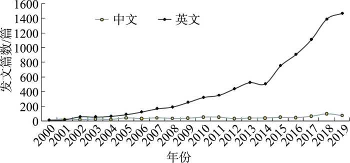

