申悦 , 柴彦威
, 柴彦威
SHEN Yue, CHAI Yanwei
收稿日期: 2017-03-10
修回日期: 2017-08-13
网络出版日期: 2018-06-28
版权声明: 2018 地理科学进展 《地理科学进展》杂志 版权所有
基金资助:
作者简介:
作者简介:申悦(1987-),女,上海人,副教授,主要研究方向为城市社会地理学与行为地理学,E-mail: shenyue0519@163.com。
展开
摘要
社会空间分异是城市社会学与城市地理学的经典研究议题,也是当前中国社会所面临的现实问题,在大量理论与实证研究的支撑下,形成了从居住空间出发的经典研究范式。而在人类移动性不断增强、居民活动日趋多样化的背景下,传统的研究范式显得静态和片面,难以反映社会空间分异与隔离问题的全貌,因此有必要从居民的日常活动空间出发探讨社会空间分异问题。国际学者们从不同视角出发对该议题进行了探索,本文对已有研究进行了梳理和述评,将已有研究总结为基于活动空间的群体分异与交往、个体活动空间的时空分异、社会空间分异的动态变化三种类型;并以时空间行为研究的理论和方法论为基础,从基于人的空间研究范式出发,构建“人群—活动空间—社会空间”基于活动空间的社会空间分异研究框架;尝试推进社会空间分异研究范式的多元化,从以人为本的立场出发理解城市空间和城市中的人。
关键词:
Abstract
Sociospatial differentiation, which reflects the uneven spatial distribution of urban social factors, is a classical research topic in urban geography and a realistic problem that the Chinese society is facing at present. Based on a large number of theoretical and empirical studies, the classical research paradigm focusing on the residential space was formed. However, with the reconstruction of urban structure and the rapid development of transportation and information and communication technologies, the activities of urban residents have become increasingly diversified and personalized. In this context, the differentiation and segregation exist not only in residential space, but also in daily activity space of residents, so the traditional research paradigm appears to be insufficient, and it is necessary to understand the sociospatial differentiation pattern from a perspective of people's activity space. Some existing studies aboard have paid attention to this new perspective and attempted to propose new research paradigms or approaches of sociospatial differentiation based on activity space using different hypotheses, methods, and data. This article reviewed existing studies and grouped them into three categories, which are social segregation and communication based on activity space, the differentiation of individuals' activity spaces, and the dynamic sociospatial differentiation. The first type of research emphasizes the social environments in which people could contact in their activity space, usually using individual data to derive activity space and census or statistical data to reflect the social background. The second category of work takes the activity space as the object of differentiation, and examines the spatiotemporal patterns based on individual behavioral data. The third kind of research focuses on the temporal dimension of sociospatial differentiation, and mobile location data and other new types of data are often used to detect the dynamic change of activity space. Based on theories and methodologies of space-time behavior and a people-based spatial research paradigm, this study built a research framework of "people-activity space-social space" to study sociospatial differentiation based on daily activity space, in order to promote the diversification of the research paradigm of sociospatial differentiation, and to understand urban space and people in cities from a human-oriented perspective.
Keywords:
社会空间分异反映了城市社会要素在空间上不均衡分布的现象,也展示了充满隔离、交叠和极化作用纷繁复杂的城市景观,是城市社会学与城市地理学的经典研究议题(Knox et al, 2000; 冯健等, 2008)。社会空间分异研究始于西方对居住隔离的关注,在大量理论和实证研究的基础上,形成了从居住空间出发,以人口统计数据为基础,采用各类社会空间分异指标或社会区、因子生态等方法,揭示社会空间结构的经典研究范式。
社会空间分异也是当前中国社会所面临的现实问题。进入快速城镇化时期以来,过于以经济建设为中心、强调空间扩张的发展模式逐渐显露出一系列弊端,城市贫困、社会隔离、交通拥堵等城市问题不断涌现(何深静等, 2010; 顾朝林, 2011; 宁越敏, 2012; 周春山等, 2013)。同时,在全球化推动社会分化加剧的背景下,在从计划经济到市场经济体制转型的过程中,中国城市的社会空间正呈现出日益分异的趋势(李志刚等, 2004; Ma et al, 2005)。在单位制度的解体、住房市场的建立和发展、产业结构的分化与重组、跨国公司和外资的大量引入、外来务工人员的进入等因素的影响下,城镇居民的社会阶层分化和居住空间分异不断加剧,从居住空间出发的社会空间分异成为受到广泛关注的热点问题(Wang et al, 1996; 顾朝林等, 1997; Wu, 2002; Wang et al, 2009)。
另一方面,随着城市空间组织的不断重构与扩张、交通技术与信息通信技术的飞速发展、个人主观能动性作用的不断加强,居民的移动性和出行需求不断提高,日常活动和生活方式日趋复杂化、多样化和个性化(周素红等, 2005; 柴彦威等, 2006; 甄峰等, 2009)。在此背景下,社会空间的分异与隔离不仅存在于居住空间,也广泛存在于居民的日常活动与出行中,传统的基于居住空间的研究就显得静态化,仅能反应居民日常生活与交往的一个侧面。因此,越来越多的学者提出,探讨社会空间分异问题有必要关注居民的日常活动空间,从更加动态和全面的视角出发理解社会空间。在居民活动日趋多样化和个性化的背景下,传统的从居住空间出发的研究范式显得有所不足。
时空间行为研究为理解人类活动和城市环境之间在时空间上的复杂关系提供了独特的视角,也为突破传统的社会空间研究范式提供了可能(Hanson et al, 1993; Kwan, 2002; Miller, 2004; Chai, 2013)。在近半个世纪的发展中,时空间行为研究的理论和方法不断完善,形成了一系列对活动空间刻画的方法论,也促进了基于人的空间研究范式的发展。基于时空间行为研究的理论和方法,利用带有居民日常活动与出行信息的活动日志数据,能够对微观个体或群体的日常活动空间进行刻画与分析,使得从活动空间与行为空间的角度出发理解城市的社会空间分异成为可能(柴彦威等, 2013; 申悦等, 2013; Kwan et al, 2015; Song et al, 2015)。国外已经开展了不少基于活动空间的社会空间分异研究,而国内的相关研究主要聚焦在居民日常活动的时空分异,对于基于活动空间的社会空间分异整体的认识与讨论仍相对缺乏,相关研究亟待开展。
本文对基于活动空间的社会空间分异研究的起源进行了阐述,对已有研究进行了梳理和总结,并结合中国城市特点,构建基于活动空间的社会空间分异研究框架,尝试推进社会空间分异研究范式的多元化,从以人为本的立场出发理解城市空间和城市中的人。
城市社会空间分异是城市社会学和城市地理学的经典研究议题,形成了从居住空间出发的经典研究范式。在西方的经典理论研究中,以芝加哥学派为代表的生态学派将居住格局视为侵入和演替的过程,试图构建城市空间的理想性结构模型,并基于人口普查数据,利用社会区分析或因子生态分析等计量方法,描述社会群体聚居所呈现出的“马赛克”式的社会空间结构(Park et al, 1925; Shevky et al, 1955; Knox et al, 2000)。也有学者结合行为主义视角,关注居民个体或家庭的居住决策,考虑家庭生命周期、家庭成员属性、住房特征等因素的作用,注重考虑居住空间的形成过程(Clark, 2009)。从居住空间出发的研究成为社会空间分异的主流研究范式,被广泛应用于对于不同收入、家庭地位、种族群体社会空间结构的研究中,探讨居住空间分异与隔离所导致的健康、经济水平、受教育程度、职住关系等不平等的社会公正问题,其中种族的居住隔离尤其受到西方学者的关注(Marcuse et al, 2000; Arbaci, 2008; Iceland et al, 2008)。
中国大陆学术界从1980年代末开始关注城市的社会空间问题,在对于西方或东欧理论和方法借鉴的基础上,基于人口普查或实地调研数据,利用社会区分析、因子生态分析、回归分析等方法,从居住空间的角度开展了一系列的理论与实证研究,揭示了中国大城市的居住空间逐渐走向分异和复杂化的趋势(许学强等, 1989; 顾朝林等, 1997; 吴启焰等, 2002; 李志刚等, 2006; 冯健等, 2008; 李志刚等, 2014)。而相对于西方城市对于种族隔离问题的关注,中国城市中低收入群体、流动人口、移民的聚居与隔离等议题也吸引了国内学者的研究兴趣(刘玉亭等, 2006; 袁媛等, 2008; 李志刚等, 2009; 林李月等, 2014)。
从居住空间出发长期作为社会空间分异研究的主流范式,一方面是由于居住空间对居民的日常生活和城市空间有重要影响,另一方面也反映了基于空间的汇总研究一直是地理学中最为传统和核心的研究范式。在中国的城市研究中,“人地关系”中的“地”往往受到更多关注。因此,即使是对于社会空间的研究,也需要基于居住地把“人”和“地”联系起来,进而把人的各类社会经济属性在空间上进行汇总、分析和可视化表达。
行为学派的发展壮大和基于人(People-based)的空间研究范式的兴起,促使了基于活动空间的社会空间分异研究的出现。1960年代后期,在人本主义思潮的影响下,出于对实证主义过分简化空间问题、忽视人的作用的不满,强调个体和微观过程的行为学派应运而生(Johnston, 2006; 柴彦威等, 2012)。其中,时间地理学出于对区域科学中的人的思考,提供了一种在时空间中从人的角度关注个体活动的视角,为地理学提供了基于人的视角与方法论,一方面为非汇总的研究提供了更多可能性,另一方面突破了传统地理学基于空间汇总的范式,使得在时空间中基于人的汇总成为可能(Hägerstrand, 1970; 柴彦威等, 2014)。
随着时空间行为研究的理论与方法论不断完善,个人数据可获取性的增加,微观模拟与基于智能体模型等技术的发展,基于人的空间研究范式逐渐被应用于各个领域的空间研究中(Kwan, 2013)。在交通地理学领域,基于人的交通调查与出行分析方法得到越来越多的关注;在健康地理学领域,基于人的空气污染暴露、疾病感染与传播研究成为研究热点;在可达性研究方面,基于人的日程安排的个体时空可达性研究成为重要的探索方向(Timmermans et al, 2002; Kwan, 2009, 2013; Delafontaine et al, 2011; Richardson et al., 2013; 马静等, 2017; 周素红等, 2017)。
在社会空间研究方面,一方面人与人的交往不仅仅发生在居住空间,也可能发生在日常活动所能到达的各类空间中;另一方面即使居住在同一地点的不同个体,其日常活动与生活方式也可能存在着巨大差异。因此,传统的从居住空间出发的社会空间分异研究范式有所不足,尤其在社会移动性与复杂性不断增加的背景下,这种研究范式相对静态和片面,已难以反映社会空间分异与隔离问题的全貌。出于对传统研究范式的批判,有学者开始强调,需要从人的日常活动和行为模式出发,以更加动态化的视角透视城市的社会空间分异问题(Wong et al, 2011; Wang et al, 2012; Farber et al, 2013; Farber et al, 2015; Li et al, 2017)。活动空间作为时空间行为研究中的重要概念,已发展出一系列相对完善的刻画方法和测度体系,既可以作为社会空间分异研究中动态的地理背景,突破居住空间相对静态化的局限;也可以作为社会空间的重要测度指标,从日常活动与行为角度反映社会空间分异,因此,学者们开始从活动空间出发研究社会空间分异(Schönfelder et al, 2003; 申悦等, 2017)。
基于活动空间的社会空间分异研究目前尚属于国际前沿议题,在基本假设与方法论上并未形成较为一致性的共识,学者们从不同的视角出发,对活动空间进行刻画,对传统的社会空间分异研究进行突破,开展基于活动空间的社会空间分异研究。
在城市社会空间的研究中,学者们提出了各种类型的指数,从不同维度对居住分异和隔离程度进行测度。Duncan等(1955)提出了分异指数(Dissimilarity Index)①(① 分异指数的计算公式:
在传统的分异指数和接触指数的基础上,一些学者试图将居住空间扩展至活动空间,基于活动空间进行分异与社会交往特征的分析。此类研究的基本假设是,人们与他人的接触和交往不仅仅发生在居住地或所在社区中,在日常活动的其他地点(如工作地、购物及休闲场所等)也可能产生社会交往。例如,一个富人即使居住在高档的、纯富人居住的社区,他也可能在工作或其他日常活动中接触到穷人,而在传统的社会空间分异与隔离的研究中,居住地之外群体之间交往的可能性往往被忽略。因此,对于不同群体的社会空间分异与隔离的研究需要考虑居住地以外日常活动所能达到的地点,即从非汇总的角度出发,研究每个个体与其活动空间内群体的差异性或交往的可能性。
有学者基于上述假设开展了方法论探讨和实证研究。Wong等(2011)在接触指数的基础上提出基于个体出行日志数据构建个体接触指数,即考虑每个个体在其活动空间中与其他群体接触的可能性,进而对个体所在的空间单元中该群体的活动空间进行汇总,即考虑居住在社区i的群体A在其活动空间中与群体B接触的可能性
Li等(2017)在分异指数和接触指数的基础上,将社会隔离理解为个体与其能够接触到的群体在社会经济属性方面的相似性,即个体在日常生活中所能接触到的社会环境与其社会身份越相似,则该个体承受了更多的社会隔离。该研究提出了将回归分析的系数作为社会隔离的测度指标的方法,其中因变量是个体的社会经济属性,自变量分别为该个体的家附近、工作地附近和活动空间内群体的社会经济属性,回归分析的显著度水平反映了隔离的显著度,回归系数反映了隔离的程度。研究的实证部分以中国香港为案例,利用770个样本的活动日志数据和人口普查数据,对年龄、收入和住房条件3个维度的隔离情况进行了探讨。该研究所提出的方法具有较强的可操作性,为不同地理背景下社会隔离情况研究提供了重要思路。
此类研究一方面利用微观个体数据(出行日志或活动日志)进行活动空间的刻画,另一方面利用人口统计数据反映社会环境背景,从而探讨基于活动空间的社会分异与交往特征,与传统的社会空间分异研究结合相对密切。
另一类研究完全从微观个体的行为数据出发,探讨个体之间活动空间的分异与交互特征。此类研究的基本假设是:即使居住在同一地点的不同个体,其日常活动与生活方式也可能存在着巨大差异。例如居住在同一地点的人群,由于其就业特点或工作地点不同,其所能接触到的人群及其对于城市空间的利用可能完全不同。尤其对于中国城市,在从计划经济到市场经济体制转型的过程中,社区内居民的同质性在下降,邻里间的交往也在减少,仅从居住空间和社会经济属性出发无法反映人与人之间巨大的差异。因此,社会空间分异研究应更多转向基于人的研究范式,从微观个体的日常活动与社会交往出发,研究活动空间的分异与交互。
一些研究从时空间结合的角度出发,考察不同群体的时空轨迹、活动空间或社交网络的差异性。Atkinson等(2004)指出,在社会隔离的研究中,有必要考虑居民的日常活动和社区之间的交往,提出了可能存在“隔离的时空轨迹(Time-space Trajectories of Segregation)”的情况。Lee等(2011)提出了社会空间隔离测度的4种可视化方法,分别是三维时空轨迹、时间窗口、三维活动密度曲面以及环状社会网络可视化,利用这4种方法表现了美国哥伦布斯地区韩国人的社会隔离状况,并指出活动模式分析和社会网络分析的结合能够帮助大家更好地理解社会空间隔离现象。
也有研究直接从行为和活动空间的角度出发,对人群进行划分。Wang等(2012)对活动空间的复杂性和多维度的特征进行了探讨,进而从活动空间的广度(Extensity)、强度(Intensity)、多样性(Diversity)和排他性(Exclusivity)4个维度出发,构建活动空间的测度指标,并在此基础上通过聚类分析从日常活动的角度出发对居民进行分类。该研究利用北京的活动日志调查数据,开展基于活动空间的社会分异实证研究,揭示了不同群体的活动空间具有非常大的差异性,这种差异不仅仅与居住地有关,城市的社会空间分异也不仅表现在居住空间的碎片化,还表现在活动空间的碎片化。
还有研究关注活动空间的交互特征,从社会交往视角出发对社会隔离进行探讨。Farber等(2013, 2014, 2015)在一系列研究中提出了社交潜力(Social Interaction Potential)的概念和测度方法,并利用此方法对城市的社会隔离特征进行研究。该方法引入了时间地理学时空棱柱(Space-time Prism)和联合可达性(Joint Accessibility)的概念,时空棱柱揭示了个体在特定时间预算条件下所能到达的时空间范围,而不同个体间时空棱柱的叠合部分就反映了多个个体的联合可达性,也揭示了个体间社会交往的机会与可能性。社交潜力的测度在城市已有的土地利用布局和设施供给的背景下,利用居民出行的OD数据,考虑在不同时间预算的条件下,城市中群体间和群体内部交往的潜在可能性。作者利用美国底特律大都市区的居民出行OD数据开展了实证研究,分别探讨了在不同时段和不同时间预算条件下,白人、黑人、西班牙裔群体内部与群体之间社会交往的潜在可能性。
此类研究通常利用微观个体数据(出行日志或活动日志)开展研究,基于人们日常活动的不同维度和社会交往,尝试构建活动空间分异与隔离的方法与指标体系,在研究范式上往往特别强调从基于人的范式出发。
第三类研究强调社会空间的分异与隔离不仅存在于空间维度上,还存在于时间维度上,即社会空间分异特征可能会随时间发生动态变化,并且这种变化在不同时间尺度上存在差异。传统的部分研究关注到了较长时间尺度上居住空间分异的变化,如社会空间极化和同化现象,但基于人们日常活动的较短时间尺度上的社会空间分异变化则较少受到关注,这主要是由于动态数据的缺乏。在大数据时代个体活动数据可获取性增加的背景下,手机定位数据、GPS轨迹、社交网络数据等新型数据成为重要的数据源,为此类研究提供了新的机会。
近年,开始有学者利用手机定位数据对社会空间分异的时间维度进行研究。Silm等(2014a, 2014b)在分异指数和接触指数的基础上,利用爱沙尼亚塔林市含有个人信息的3年手机定位数据,分别以3小时、1天和3个月为时间单元,测度俄罗斯裔和爱沙尼亚裔群体在1天、1周和1年之内社会空间分异的动态变化特征。研究发现塔林的种族隔离在1天尺度上的变化最为显著,表现为早晚的种族隔离较强,而工作时间的种族隔离相对较弱;在1周尺度上,周末的种族隔离相对较强,工作日的种族隔离相对较弱;在1年尺度上,冬季的种族隔离相对较强,夏季的种族隔离相对较弱。研究反映了时间维度对于社会空间分异研究的重要性。
由于带有个人信息的手机定位数据难以获取,此类研究并不多见。国内也有一些研究基于新型数据关注居民活动空间的动态变化,例如,王波(2013)利用微博签到数据分析了南京市城市活动空间的动态变化,并对城市活动区域进行划分,然而,对于社会空间分异这一议题的探讨仍然较为缺乏。
综上,基于活动空间的社会空间分异研究目前是国际前沿研究问题,对传统的基于居住地的、关注种族问题的社会空间分异研究形成了挑战(Kwan, 2013)。本文将已有研究分为基于活动空间的群体分异与交往、个体活动空间的时空分异、社会空间分异的动态变化3类,并对各类研究的特征进行了总结(表1)。
表1 基于活动空间的社会空间分异研究类型与特征
Tab.1 A summary of socio-spatial differentiation based on daily activity space
| 研究内容 | 基于活动空间的群体分异与交往 | 个体活动空间的时空分异 | 社会空间分异的动态变化 |
|---|---|---|---|
| 基本假设 | 群体间交往不仅发生居住地,还可能发生在日常活动的其他地点 | 居住在同一地点的不同个体,其日常活动与生活方式也可能存在着巨大差异 | 社会空间的分异与隔离不仅存在于空间维度上,还存在于时间维度上 |
| 研究数据 | 个体行为数据与社会人口统计数据相结合 | 微观个体行为数据 | 手机、GPS、社交网络等带有动态信息的新型数据 |
| 研究特点 | 微观行为数据刻画活动空间,社会人口统计数据反映社会环境背景 | 基于人的研究范式 | 时间与空间维度相结合 |
相对于传统的社会空间分异研究,基于活动空间的社会空间分异研究在研究议题方面,不仅关注居住空间的分异,还关注日常活动、出行与交往的分异,不仅关注种族等不同群体间的分异,还关注微观个体间的分异;在研究数据方面,将传统的社会人口统计数据与微观个体行为数据以及大数据时代各类动态化的新型数据相结合;在研究方法方面,对传统社会空间分异研究的各类指数进行拓展,并与时空间行为研究方法以及面向大数据的GIS分析方法相结合;在研究范式方面,将空间维度与时间维度、基于空间与基于人的研究相结合。
目前,国外基于活动空间的社会空间分异研究仍处于理论和方法的探索阶段,而国内对于这方面的探讨主要集中在不同群体日常活动的时空分异方面。因此,有必要结合中国国情构建研究框架,从居民日常活动空间出发开展社会空间分异的研究。
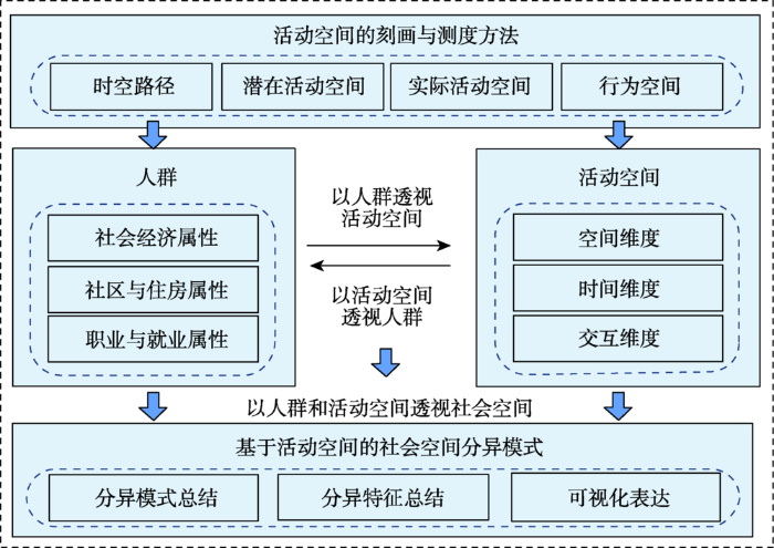
本文在对已有研究进行梳理的基础上,将时空间行为研究与社会空间分异议题相结合,从基于人的空间研究范式出发,尝试构建“人群—活动空间—社会空间”的研究框架(图1),基于居民的日常活动空间进行社会空间分异研究。
图1 基于活动空间的社会空间分异研究框架
Fig.1 Research framework of sociospatial differentiation based on daily activity space
不同时空间行为理论背景下的活动空间具有不同的内涵:时间地理学强调客观制约,其理论基础上的活动空间强调在时空制约下的实际时空路径和潜在活动空间;行为地理学强调主观认知、偏好与决策,其理论基础上的活动空间不仅强调可以观察到的活动空间,而且强调个体所能感知到的、影响行为决策的行动空间;人类活动分析法在对于城市活动—移动系统的研究中强调主观决策和客观制约共同作用下的行为结果,其理论基础上的活动空间强调个体所到达的实际活动空间。对不同理论背景下的活动空间概念及其相应的刻画方法进行梳理,并结合GIS基于不同的方法对活动空间的刻画加以实现,通过对不同方法的刻画结果和测度指标的对比分析,总结针对城市研究中不同的研究问题、合适的活动空间刻画和测度方法。
结合微观个体调查和各类新型数据,在对居民活动空间进行刻画的基础上,分析不同人群的活动空间模式。具体可包括:①不同社会经济属性居民的活动空间特征,如中产阶级居民、低收入居民、女性、老年人、流动人口等;②不同居住区位、社区类型与迁居历程居民的活动空间特征,如居住在中心城区、近郊或远郊,商品房、社会保障房、拆迁安置房、城中村等社区,城市迁出、就地非农化、郊区迁入、外地迁入等迁居历程;③不同就业区位、就业类型居民的活动空间特征,如在中心城区、近郊或远郊就业,国企及事业单位、民营企业、个体经营等就业性质,长距离通勤、早出晚归、不规律通勤等通勤时空特征。结合城市空间结构和居民的社会经济属性分析居民活动空间的影响机理,从不同人群出发透视活动空间。
结合微观个体调查和各类新型数据,在对居民活动空间进行刻画的基础上,直接从活动空间出发,选取适当的测度指标,构建用于社会空间分异研究的活动空间测度指标体系,可包括活动空间的空间维度(如空间范围、分布方向)、时间维度(如时间强度)、交互维度(不同个体活动空间之间的交互)等;利用聚类分析、因子分析等计量方法,基于选取的活动空间指标进行分析,得到不同的活动空间模式;对各类活动空间模式进行描述和分析,尤其是通过聚类分析或因子分析提取出来的部分极端行为,如超长通勤距离、较为破碎的时空利用等;找到各类活动空间模式对应的人群,对人群特征加以分析,从活动空间的不同模式出发透视人群特征。
将不同人群的活动空间分异模式和基于活动空间的人群分异模式研究进行整合和总结,提炼出社会空间分异的模式和特征,从时间、空间、活动、人群等多个维度理解和透视社会空间。并结合空间分析和可视化方法,将这种多维度的分异模式在空间上进行可视化表达。
社会空间分异是城市社会学与城市地理学的经典研究议题,也是当前中国社会所面临的现实问题,在大量理论与实证研究的支撑下,形成了从居住空间出发的经典研究范式。而在人类移动性不断增强、居民活动日趋多样化的背景下,传统的研究范式显得有所不足。行为学派的发展壮大和基于人(People-based)的空间研究范式的兴起,促使了基于活动空间的社会空间分异研究的出现。
目前,基于活动空间的社会空间分异研究是国际前沿研究问题,国际学者们从不同视角出发对该议题进行了探索。本文对已有研究进行梳理和总结,将相关研究分为3类。第一类研究强调人们在其活动空间中所能接触到的社会环境,利用微观个体数据进行活动空间的刻画,利用人口统计数据反映社会环境背景,从而探讨基于活动空间的社会分异与交往特征。第二类研究强调将活动空间本身视为分异的对象,从微观个体的行为数据出发,探讨个体之间活动空间的时空分异特征,强调基于人的研究范式。第三类研究强调社会空间分异的时间维度,关注该现象在不同时间尺度上的动态变化,利用手机定位数据等新型数据源开展实证研究。
国际已有研究为国内相关研究的推进提供了重要思路,本文以时空间行为研究的理论和方法论为基础,结合中国城市的特点,从基于人的空间研究范式出发,构建基于活动空间的社会空间分异研究框架。结合微观个体调查数据和新型数据,在对活动空间进行刻画和测度的基础上,构建了“人群—活动空间—社会空间”的框架,分析不同人群的活动空间特征,以人群透视活动空间;分析不同活动空间对应的人群特征,以活动空间透视人群;进而提炼城市的社会空间分异模式。
随着以人为本理念的深入人心,基于人的空间研究范式将成为城市研究发展的重要方向。本文聚焦于社会空间分异研究,从微观个体活动空间的角度出发进行了探讨。未来研究可结合GPS、智能手机、社交网络等新型数据,从多个时空尺度和维度出发,开展个体和群体的活动空间研究;同时对社会空间的内涵进行深入的挖掘和探讨,推进社会空间研究范式的多元化和人本化。
The authors have declared that no competing interests exist.
| [1] |
|
| [2] |
|
| [3] |
基于居民移动: 活动行为的城市空间研究 [J].https://doi.org/10.3969/j.issn.1003-2398.2006.05.024 URL [本文引用: 1] 摘要
在以人为本及后现代思潮的大背景下,人文地理学研究越来越关注个体人的行为以及生活质量问题,基于居民移动-活动行为的城市空间研究正成为人文地理及城市规划学等学科的焦点。论文在对城市活动空间研究及城市交通出行研究中的问题进行梳理的基础上,提出一个基于居民移动-活动行为的城市空间研究新框架,强调行为与空间之间的互动关系,强调RP法和SP法的结合,强调现实行为、现实空间与理想行为、理想空间之间的和谐。
Travel-activity based research frame of urban spatial structure [J].https://doi.org/10.3969/j.issn.1003-2398.2006.05.024 URL [本文引用: 1] 摘要
在以人为本及后现代思潮的大背景下,人文地理学研究越来越关注个体人的行为以及生活质量问题,基于居民移动-活动行为的城市空间研究正成为人文地理及城市规划学等学科的焦点。论文在对城市活动空间研究及城市交通出行研究中的问题进行梳理的基础上,提出一个基于居民移动-活动行为的城市空间研究新框架,强调行为与空间之间的互动关系,强调RP法和SP法的结合,强调现实行为、现实空间与理想行为、理想空间之间的和谐。
|
| [4] |
中国时空间行为研究进展 [J].https://doi.org/10.11820/dlkxjz.2013.09.006 Magsci [本文引用: 1] 摘要
自时间地理学和活动分析法引入中国以来的近20年间,时空间行为研究已经成为中国城市地理学的重要领域。中国时空间行为研究关注城市空间重构的描述与解释,试图从行为角度解释中国城市社会转型,强调转型期中国城市空间与居民个体行为之间的互动关系,重视日常生活、生活质量、社会公正、低碳社会、智慧城市等热点问题,探索在城市交通、旅游和城市规划等领域中的实践应用。中国时空间行为研究已经形成了以解读城市转型为目标、以规划应用为导向的鲜明特点,为理解中国城市制度与空间转型背景下人类行为模式的复杂性和多样性提供了一个全新的视角。但是,中国时空间行为研究依然面临着理论发展滞后、实践应用需要突破等挑战。本文是对时空行为研究近年来发展的综述性文章,从数据采集与分析方法演进、实证研究与规划应用进展等方面回顾了近20年来中国城市时空间行为研究的最新进展,致力于推动不同学科领域之间的交流和时空间行为研究自身的发展。
Progress in space-time behavior research in China [J].https://doi.org/10.11820/dlkxjz.2013.09.006 Magsci [本文引用: 1] 摘要
自时间地理学和活动分析法引入中国以来的近20年间,时空间行为研究已经成为中国城市地理学的重要领域。中国时空间行为研究关注城市空间重构的描述与解释,试图从行为角度解释中国城市社会转型,强调转型期中国城市空间与居民个体行为之间的互动关系,重视日常生活、生活质量、社会公正、低碳社会、智慧城市等热点问题,探索在城市交通、旅游和城市规划等领域中的实践应用。中国时空间行为研究已经形成了以解读城市转型为目标、以规划应用为导向的鲜明特点,为理解中国城市制度与空间转型背景下人类行为模式的复杂性和多样性提供了一个全新的视角。但是,中国时空间行为研究依然面临着理论发展滞后、实践应用需要突破等挑战。本文是对时空行为研究近年来发展的综述性文章,从数据采集与分析方法演进、实证研究与规划应用进展等方面回顾了近20年来中国城市时空间行为研究的最新进展,致力于推动不同学科领域之间的交流和时空间行为研究自身的发展。
|
| [5] |
转型期北京社会空间分异重构 [J].Restructuring of socio-spatial differentiation in Beijing in the transition period [J]. |
| [6] |
转型发展与未来城市的思考 [J].Transitional development and future urban forms [J]. |
| [7] |
北京社会极化与空间分异研究 [J].https://doi.org/10.11821/xb199705001 URL [本文引用: 2] 摘要
本文论述了北京近年来经济体制改革和社会主义市场经济制度运行对城市社会结构的影响,尤其集中在:1.城市社会极化及其动力机制;2.新城市贫困现象及其原因;3城市社会空间分异及其人变化趋势等。
Social polarisation and segregation phenomenon in Beijing [J].https://doi.org/10.11821/xb199705001 URL [本文引用: 2] 摘要
本文论述了北京近年来经济体制改革和社会主义市场经济制度运行对城市社会结构的影响,尤其集中在:1.城市社会极化及其动力机制;2.新城市贫困现象及其原因;3城市社会空间分异及其人变化趋势等。
|
| [8] |
中国大城市低收入邻里及其居民的贫困集聚度和贫困决定因素 [J].Poverty concentration and determinants in low-income neighbourhoods and social groups in Chinese large cities [J]. |
| [9] |
转型期上海社会空间分异研究 [J].https://doi.org/10.3321/j.issn:0375-5444.2006.02.009 URL [本文引用: 1] 摘要
Using the 5th census data on the spatial level of neighborhood committee, the lowest administrative level of urban China, this paper examines sociospatial differentiation in post-reform Shanghai. By applying the traditional method of factorial analysis, six types of social areas are identified: worker villages built before reform, migrant communities, professional complexes, peasant villages, new-worker villages and aged accumulated inner-city. Accordingly, the post-reform sociospatial structure of Shanghai is a model combining the three classic structures: concentric layers, clusters, and multi-nuclei. Our findings suggest that residential district (jiedao) is heterogeneous, thus we argue that the social area should be studied on lower spatial levels. In this sense, we further examine to what extent social space is differentiated. It suggests that neither demographic variables nor socio-economic variables have significant differentiation as those in the West; instead, there is rather a high extent of housing differentiation. The underlying reason is attributed to the institutional forces such as work-unit, i.e. their impact upon housing in history and their impact in the post-reform era. This distinctive mechanism indicates that now the extent of sociospatial differentiation of urban China is still much lower than that of Western cities.
Sociospatial differentiation in transitional Shanghai [J].https://doi.org/10.3321/j.issn:0375-5444.2006.02.009 URL [本文引用: 1] 摘要
Using the 5th census data on the spatial level of neighborhood committee, the lowest administrative level of urban China, this paper examines sociospatial differentiation in post-reform Shanghai. By applying the traditional method of factorial analysis, six types of social areas are identified: worker villages built before reform, migrant communities, professional complexes, peasant villages, new-worker villages and aged accumulated inner-city. Accordingly, the post-reform sociospatial structure of Shanghai is a model combining the three classic structures: concentric layers, clusters, and multi-nuclei. Our findings suggest that residential district (jiedao) is heterogeneous, thus we argue that the social area should be studied on lower spatial levels. In this sense, we further examine to what extent social space is differentiated. It suggests that neither demographic variables nor socio-economic variables have significant differentiation as those in the West; instead, there is rather a high extent of housing differentiation. The underlying reason is attributed to the institutional forces such as work-unit, i.e. their impact upon housing in history and their impact in the post-reform era. This distinctive mechanism indicates that now the extent of sociospatial differentiation of urban China is still much lower than that of Western cities.
|
| [10] |
城市社会空间分异: 倡导还是控制 [J].Residential segregation in urban China: Push vs control [J]. |
| [11] |
基于全国第六次人口普查数据的广州新移民居住分异研究 [J].Residential segregation of new migrants in Guangzhou, China: A study of the 6th Census [J]. |
| [12] |
全球化下“跨国移民社会空间”的地方响应: 以广州小北黑人区为例 [J].https://doi.org/10.3321/j.issn:1000-0585.2009.04.007 URL [本文引用: 1] 摘要
全球化下的中国城市社会空间面临新的重塑,以诸多大城市新近出现的跨国移民社会空间的发展最为突出。本文以广州小北黑人区为研究对象,采用三角检验法,综合利用问卷调查、深度访谈等研究手段,探讨全球化下中国城市所出现的新社会空间的地方响应。总体上,一个负面的黑人群体形象已经被建构起来。就居民的年龄、性别、教育水平、居住时间和宗教信仰等方面而言,各类本地居民在对黑人聚居的看法上并无太大差别;但不同职业类型的居民看法差别很大。排斥心理的产生多源于外在信息的影响,亦即本地媒体排斥、矮化性的负面响应。
The local response of transnational social space under globalization in urban China: A case study of African enclave in Guangzhou [J].https://doi.org/10.3321/j.issn:1000-0585.2009.04.007 URL [本文引用: 1] 摘要
全球化下的中国城市社会空间面临新的重塑,以诸多大城市新近出现的跨国移民社会空间的发展最为突出。本文以广州小北黑人区为研究对象,采用三角检验法,综合利用问卷调查、深度访谈等研究手段,探讨全球化下中国城市所出现的新社会空间的地方响应。总体上,一个负面的黑人群体形象已经被建构起来。就居民的年龄、性别、教育水平、居住时间和宗教信仰等方面而言,各类本地居民在对黑人聚居的看法上并无太大差别;但不同职业类型的居民看法差别很大。排斥心理的产生多源于外在信息的影响,亦即本地媒体排斥、矮化性的负面响应。
|
| [13] |
基于六普数据的中国流动人口住房状况的空间格局 [J].https://doi.org/10.11821/dlyj201405008 URL [本文引用: 1] 摘要
住房是流动人口融入城市、实现市民化过程中必须解决的关键问题。基于2010年第六次人口普查数据,采用住房拥有率、租住房率、住房面积指数、住房不受干扰指数、住房质量指数和住房费用指数6个指标考察流动人口的住房状况,并综合运用数理统计、空间自相关和系统聚类法揭示流动人口住房状况的属性特征、空间分布与集聚类型。研究发现,与城镇常住人口相比,流动人口的住房状况较差。从空间分布看,流动人口住房状况的各项指标具有显著的空间正相关,在空间分布上不仅存在集聚现象,而且有明显的集聚中心。研究结果还表明,流动人口住房条件综合状况可划分为较好、中等、中等偏下、较差4级类型区,在全国尺度上的空间分布除个别类型外具有团块聚合的结构特征。在考虑社会公平的前提下,应分类解决不同类型区域流动人口的住房问题。
The spatial patterns of housing conditions of the floating population in China based on the Sixth Census data [J].https://doi.org/10.11821/dlyj201405008 URL [本文引用: 1] 摘要
住房是流动人口融入城市、实现市民化过程中必须解决的关键问题。基于2010年第六次人口普查数据,采用住房拥有率、租住房率、住房面积指数、住房不受干扰指数、住房质量指数和住房费用指数6个指标考察流动人口的住房状况,并综合运用数理统计、空间自相关和系统聚类法揭示流动人口住房状况的属性特征、空间分布与集聚类型。研究发现,与城镇常住人口相比,流动人口的住房状况较差。从空间分布看,流动人口住房状况的各项指标具有显著的空间正相关,在空间分布上不仅存在集聚现象,而且有明显的集聚中心。研究结果还表明,流动人口住房条件综合状况可划分为较好、中等、中等偏下、较差4级类型区,在全国尺度上的空间分布除个别类型外具有团块聚合的结构特征。在考虑社会公平的前提下,应分类解决不同类型区域流动人口的住房问题。
|
| [14] |
转型期城市低收入邻里的类型、特征和产生机制: 以南京市为例 [J].Typology, features and mechanism of urban low-income neighborhoods under market transition: A case study of Nanjing [J]. |
| [15] |
居民时空行为与环境污染暴露对健康影响的研究进展 [J].Progress of research on the health impact of people's space-time behavior and environmental pollution exposure [J]. |
| [16] |
中国城市化特点、问题及治理 [J].https://doi.org/10.3969/j.issn.1001-8263.2012.10.003 URL [本文引用: 1] 摘要
中国已进入快速城市化时期,2011年的城市化率超过了50%。本文首先分析了当代中国城市化的三个特点,即规模大、速度快,半城市化现象显著;城市化的区域差异显著;都市化现象已经显现,大城市群成为国家经济的核心地区。其次,从三个方面分析了中国城市问题出现的原因。针对中国城市化进程中的问题,本文从政策制定和空间策略两方面提出了两个建议,一是认为要深化改革,逐步解决半城市化的问题,二是要实施都市区和城市群发展战略,预防城市病的发生。
A study on the urbanization, urban problems and solution in China [J].https://doi.org/10.3969/j.issn.1001-8263.2012.10.003 URL [本文引用: 1] 摘要
中国已进入快速城市化时期,2011年的城市化率超过了50%。本文首先分析了当代中国城市化的三个特点,即规模大、速度快,半城市化现象显著;城市化的区域差异显著;都市化现象已经显现,大城市群成为国家经济的核心地区。其次,从三个方面分析了中国城市问题出现的原因。针对中国城市化进程中的问题,本文从政策制定和空间策略两方面提出了两个建议,一是认为要深化改革,逐步解决半城市化的问题,二是要实施都市区和城市群发展战略,预防城市病的发生。
|
| [17] |
基于GPS数据的北京市郊区巨型社区居民日常活动空间 [J].Daily activity space of suburban mega-community residents in Beijing based on GPS data [J]. |
| [18] |
基于生活空间与活动空间视角的郊区空间研究框架 [J].
郊区空间已成为城市空间的重要组成部分,其研究意义逐渐凸显,需要学者立足郊区,关注郊区空间及其与城市空间的关系。本文从行为主义地理学和时间地理学的理论和方法论出发,对行为空间、生活空间、活动空间的概念进行辨析,提出了基于空间范式下的生活空间研究和基于人范式下的活动空间研究两方面研究内容。立足于郊区空间,面向居民日常生活,构建基于时空间行为研究方法论的郊区空间研究框架,基于此框架对郊区生活空间、郊区活动空间以及郊区空间的动态性进行解读和分析,试图为空间—行为互动理论的构建提供研究基础,为基于行为视角的郊区研究提供研究框架,为更好的理解郊区空间、解决郊区中存在的问题提供有效途径。
Research framework of suburban space based on space-time behavior methodology [J].
郊区空间已成为城市空间的重要组成部分,其研究意义逐渐凸显,需要学者立足郊区,关注郊区空间及其与城市空间的关系。本文从行为主义地理学和时间地理学的理论和方法论出发,对行为空间、生活空间、活动空间的概念进行辨析,提出了基于空间范式下的生活空间研究和基于人范式下的活动空间研究两方面研究内容。立足于郊区空间,面向居民日常生活,构建基于时空间行为研究方法论的郊区空间研究框架,基于此框架对郊区生活空间、郊区活动空间以及郊区空间的动态性进行解读和分析,试图为空间—行为互动理论的构建提供研究基础,为基于行为视角的郊区研究提供研究框架,为更好的理解郊区空间、解决郊区中存在的问题提供有效途径。
|
| [19] |
国内外社会空间分异测度研究综述 [J].https://doi.org/10.18306/dlkxjz.2015.07.004 URL [本文引用: 1] 摘要
社会空间分异作为一个具有社会性及空间性的概念,其测度研究直接关系到隔离等级划分的合理性和有效性。本文根据不同历史时期空间分异测度研究所关注的视角,将社会空间分异测度研究分为早期萌芽阶段、多维度群体评估阶段、空间转向阶段、多模型多视角阶段等4个阶段,介绍了社会空间分异测度指标在各阶段的演变特点和主要测度指标,并对其中26个主要指数进行比较和分类,阐述各指数的适用范围和优缺点。分析国内社会空间分异相关研究现状,指出其存在多维度指标使用较少且多为实证性研究,空间分异测算方法缺少理论基础的不足。移动互联网和社交网络空间快速发展,对社会空间分异的测算方法提出新的要求;基于地理位置信息的个人行为空间交互数据和基于虚拟网络的赛博空间交互数据,为社会空间分异研究提供了新的研究视角。
A review of social spatial segregation measurements [J].https://doi.org/10.18306/dlkxjz.2015.07.004 URL [本文引用: 1] 摘要
社会空间分异作为一个具有社会性及空间性的概念,其测度研究直接关系到隔离等级划分的合理性和有效性。本文根据不同历史时期空间分异测度研究所关注的视角,将社会空间分异测度研究分为早期萌芽阶段、多维度群体评估阶段、空间转向阶段、多模型多视角阶段等4个阶段,介绍了社会空间分异测度指标在各阶段的演变特点和主要测度指标,并对其中26个主要指数进行比较和分类,阐述各指数的适用范围和优缺点。分析国内社会空间分异相关研究现状,指出其存在多维度指标使用较少且多为实证性研究,空间分异测算方法缺少理论基础的不足。移动互联网和社交网络空间快速发展,对社会空间分异的测算方法提出新的要求;基于地理位置信息的个人行为空间交互数据和基于虚拟网络的赛博空间交互数据,为社会空间分异研究提供了新的研究视角。
|
| [20] |
基于位置服务数据的城市活动空间研究 [D].A study of urban activity space based on location-based services data [D]. |
| [21] |
现代中国城市居住空间分异机制的理论研究 [J].https://doi.org/10.3969/j.issn.1003-2398.2002.03.007 URL [本文引用: 1] 摘要
通过住宅市场空间分异研究体系的建立,认为城市居住空间分异是社会阶(层)级分化结果通过市场宏观控制、个体择居行为心理的局部调整而实现的空间化过程.因此,居住空间分异机制可以从对住房市场空间分化及个体择居行为机制两个方面来理解.从五个方面具体分析影响城市住宅市场分化的机构、各种机构对城市居住空间、社会空间分异的影响力:(1)政府作为土地所有者及其作用形态;(2)城市建筑商、地产开发商的发展方式;(3)金融信贷业对社会空间和物质空间的空间非均衡的影响;(4)地产物业机构对邻里的操纵和强化;(5)城市规划思想与方法的影响.并认为影响我国城市社会地理空间分异的宏观背景是:(1)国内自1978年以来的政治经济体制改革,它确定我们的主要研究框架;(2)自80年代末期开始强化的经济全球化与区域集团造就的新国际劳动分工;(3)信息技术革命为核心的知识经济及其影响下的经济结构变化.
The dynamic mechanism of urban residential differentiation in China [J].https://doi.org/10.3969/j.issn.1003-2398.2002.03.007 URL [本文引用: 1] 摘要
通过住宅市场空间分异研究体系的建立,认为城市居住空间分异是社会阶(层)级分化结果通过市场宏观控制、个体择居行为心理的局部调整而实现的空间化过程.因此,居住空间分异机制可以从对住房市场空间分化及个体择居行为机制两个方面来理解.从五个方面具体分析影响城市住宅市场分化的机构、各种机构对城市居住空间、社会空间分异的影响力:(1)政府作为土地所有者及其作用形态;(2)城市建筑商、地产开发商的发展方式;(3)金融信贷业对社会空间和物质空间的空间非均衡的影响;(4)地产物业机构对邻里的操纵和强化;(5)城市规划思想与方法的影响.并认为影响我国城市社会地理空间分异的宏观背景是:(1)国内自1978年以来的政治经济体制改革,它确定我们的主要研究框架;(2)自80年代末期开始强化的经济全球化与区域集团造就的新国际劳动分工;(3)信息技术革命为核心的知识经济及其影响下的经济结构变化.
|
| [22] |
广州市社会空间结构的因子生态分析 [J].A factorial ecological study of social spatial structure in Guangzhou [J]. |
| [23] |
广州市外来人口居住隔离及影响因素研究 [J].Residential segregation of floating population and driving forces in Guangzhou City [J]. |
| [24] |
信息技术对城市居民出行特征的影响: 以南京为例 [J].The impact of information technology on the characteristics of urban resident travel: Case of Nanjing [J]. |
| [25] |
中国城市空间结构研究评述 [J].https://doi.org/10.11820/dlkxjz.2013.07.006 URL Magsci [本文引用: 1] 摘要
中国正处于城市化快速发展时期, 城市空间结构面临关键转型, 相关研究日益受到重视, 研究数量不断增多, 深度不断加强。因此, 有必要对中国城市空间结构相关研究进行系统总结, 从中找出存在的问题, 以及与国际相关研究的差距。基于对20 世纪80 年代以来中国城市空间结构相关研究成果的数量统计, 将其划分为3 个主要的研究时期:① 20 世纪80-90 年代中期, 为西方城市空间结构理论引入期及国内实证研究的起步期;② 20 世纪90年代中期-21 世纪初, 为中国城市空间结构的研究积累期;③ 21 世纪初至今, 为中国城市空间结构模式的总结及新城市空间现象研究的多元化时期。在对各个时期主要相关研究成果进行梳理和总结的基础上, 对比当前国际研究的最新成果, 提出未来中国城市空间结构的重点研究领域应当集中于:转型期城市空间结构理论模式的探讨, 新城市空间现象的深入探讨, 节约型城市空间增长的研究, 城市空间结构深层机制的分析, 中、微观尺度研究领域的开拓, 新研究方法的应用等6个方面。
Progress on studies of urban spatial structure in China [J].https://doi.org/10.11820/dlkxjz.2013.07.006 URL Magsci [本文引用: 1] 摘要
中国正处于城市化快速发展时期, 城市空间结构面临关键转型, 相关研究日益受到重视, 研究数量不断增多, 深度不断加强。因此, 有必要对中国城市空间结构相关研究进行系统总结, 从中找出存在的问题, 以及与国际相关研究的差距。基于对20 世纪80 年代以来中国城市空间结构相关研究成果的数量统计, 将其划分为3 个主要的研究时期:① 20 世纪80-90 年代中期, 为西方城市空间结构理论引入期及国内实证研究的起步期;② 20 世纪90年代中期-21 世纪初, 为中国城市空间结构的研究积累期;③ 21 世纪初至今, 为中国城市空间结构模式的总结及新城市空间现象研究的多元化时期。在对各个时期主要相关研究成果进行梳理和总结的基础上, 对比当前国际研究的最新成果, 提出未来中国城市空间结构的重点研究领域应当集中于:转型期城市空间结构理论模式的探讨, 新城市空间现象的深入探讨, 节约型城市空间增长的研究, 城市空间结构深层机制的分析, 中、微观尺度研究领域的开拓, 新研究方法的应用等6个方面。
|
| [26] |
郊区化背景下居民健身活动时空约束对心理健康影响: 以广州为例 [J].Effects of spatial-temporal constraints of suburban residents on fitness activities to mental health in the context of rapid suburbanization: A case study in Guangzhou, China [J]. |
| [27] |
广州城市空间结构与交通需求关系 [J].https://doi.org/10.3321/j.issn:0375-5444.2005.01.015 URL [本文引用: 1] 摘要
在综述国内外相关研究的基础上,以广州为案例研究城市空间结构与交通需求的关系.结果表明,在城市形态与交通需求的关系方面,广州城市二维形态和三维形态与交通需求的空间分布之间具有一定的耦合性,二者存在一定互为因果的关系;交通方式的转化对城市形态的演化具有一定的驱动作用;城市形态引导着交通需求的总量和布局;同时,社会经济活动及其发展是城市形态与交通需求产生的原因和相互联系的纽带.在城市内部空间结构与交通需求的关系方面,模型分析表明,近年来广州城市内部居住与就业的空间均衡性增强,直接影响了交通需求的产生与分布和交通方式的选择,有利于居民就近选择就业,并使通勤交通的空间分布更加均衡;此外,居住与就业人口迁移先行,引导公共设施的发展也是近年来广州城市发展的主要特征之一;公共设施服务空间与交通需求之间存在需求作用型和供给作用型两种相互作用模式.
The relationship between urban structure and traffic demand in Guangzhou [J].https://doi.org/10.3321/j.issn:0375-5444.2005.01.015 URL [本文引用: 1] 摘要
在综述国内外相关研究的基础上,以广州为案例研究城市空间结构与交通需求的关系.结果表明,在城市形态与交通需求的关系方面,广州城市二维形态和三维形态与交通需求的空间分布之间具有一定的耦合性,二者存在一定互为因果的关系;交通方式的转化对城市形态的演化具有一定的驱动作用;城市形态引导着交通需求的总量和布局;同时,社会经济活动及其发展是城市形态与交通需求产生的原因和相互联系的纽带.在城市内部空间结构与交通需求的关系方面,模型分析表明,近年来广州城市内部居住与就业的空间均衡性增强,直接影响了交通需求的产生与分布和交通方式的选择,有利于居民就近选择就业,并使通勤交通的空间分布更加均衡;此外,居住与就业人口迁移先行,引导公共设施的发展也是近年来广州城市发展的主要特征之一;公共设施服务空间与交通需求之间存在需求作用型和供给作用型两种相互作用模式.
|
| [28] |
|
| [29] |
Fortress UK? Gated communities, the spatial revolt of the elites and time-space trajectories of segregation [J].https://doi.org/10.1080/0267303042000293982 URL [本文引用: 1] 摘要
Anecdotal evidence suggests that ‘gated communities’ are growing in popularity. This paper uses empirical evidence to profile the location and characteristics of gated development in England and details the relative integration of residents. The paper also attempts to think through the wider theoretical and urban policy impacts of gating. In contrast to the view that gated communities provide an extreme example of residential segregation we go further and argue that the time‐space trajectories of residents suggest a dynamic pattern of separation that goes beyond the place of residence. Gated communities appear to provide an extreme example of more common attempts by other social groups to insulate against perceived risk and unwanted encounters. Patterns of what we term time‐space trajectories of segregation can thereby be seen as closed linkages between key fields, such as work and home, which enable social distance to be maintained and perceived risks to be managed by elite social groups. We conclude that gated communities further extend contemporary segregatory tendencies in the city and that policy responses are required which curtail the creation of such havens of social withdrawal.
|
| [30] |
A probability model for the measurement of ecological segregation [J].https://doi.org/10.2307/2574118 URL [本文引用: 1] |
| [31] |
Space-time behavior research in China: Recent development and future prospect [J].https://doi.org/10.1080/00045608.2013.792179 URL [本文引用: 1] 摘要
The space-time behavior approach has become an influential methodology in Chinese urban geography. In this article I provide an overview of space-time behavior research in China, focusing on theoretical and methodological progress as well as key themes and findings from recent empirical studies. I argue that space-time behavior research offers a new perspective for understanding the complexity and diversity of human behavior patterns during the large-scale spatial and institutional transition in Chinese cities. Yet although Chinese urban geographers have made more methodological progress in data collection and analytic tools, theoretical development still lags behind compared to the space-time behavior approach in the West. The article concludes by discussing key theoretical and practical challenges for future development of space-time activity research in China.
|
| [32] |
Changing residential preferences across income, education, and age: Findings from the multi-city study of urban inequality [J].https://doi.org/10.1177/1078087408321497 URL [本文引用: 1] |
| [33] |
The impact of opening hours on the equity of individual space-time accessibility [J].https://doi.org/10.1016/j.compenvurbsys.2011.02.005 URL [本文引用: 1] 摘要
While many studies have concentrated on the effects of the spatial distribution of services on individual accessibility, only little is known about the ways in which equity of individual accessibility is affected by the temporal organisation of service delivery. This paper seeks to deepen our understanding about the relationship between accessibility, equity and the opening hours of public service facilities on the basis of space ime accessibility measures. Three approaches based on different equity principles are presented to schedule the opening hours of public service facilities: a utilitarian, an egalitarian and a distributive approach. A case study of public libraries in Ghent (Belgium) demonstrates the relevance of these approaches for amending the opening hours of public services to control the equity of accessibility levels across individuals.Highlights? The opening hours of services affect the equity individual accessibility. ? Utilitarian, egalitarian and distributive approach to schedule service opening hours. ? Case study on rescheduling opening hours of the public libraries in Ghent (Belgium). ? The distribution of accessibility is strongly influenced by the scheduling procedure. ? Equitable/progressive rescheduling comes at the expense of the accessibility level.
|
| [34] |
A methodological analysis of segregation indexes [J].https://doi.org/10.2307/25514906 URL [本文引用: 1] 摘要
ABSTRACT The abstract for this document is available on CSA Illumina.To view the Abstract, click the Abstract button above the document title.
|
| [35] |
Social interaction potential and the spatial distribution of face-to-face social interactions [J].https://doi.org/10.1068/b120034p URL [本文引用: 1] 摘要
This paper investigates the spatial distribution of social activity locations. The research makes use of a social interaction potential (SIP) metric to estimate the potential for an individual to participate in a face-to-face social activity at any particular location in the city. The metric is shown to constitute a contact probability field that is sensitive to time-geographic constraints such as home locations, workplaces, and travel times. Empirical case studies drawn from samples in Ghent, Belgium and Concepci n, Chile are used to evaluate the effectiveness of the SIP metric in assigning high potential scores to observed social activity episodes. Moreover, a regression model is used to estimate the marginal benefit of using successive levels of constraint detail. The results illustrate both positive and negative aspects of the SIP metric. The metric behaves very well in general; 75% of the time an observed activity location received a score in the 25th percentile. However, lower valued scores were more common in cases when the time-geographic constraints were not very strong (ie, when the commute duration was short), or when activities took place in the homes of the respondents. In the end, the results are a step towards validating the regional scale SIP metric and indicate that it may be useful in microsimulation models of daily travel and activity participation.
|
| [36] |
The social interaction potential of metropolitan regions: A time-geographic measurement approach using joint accessibility [J].https://doi.org/10.1080/00045608.2012.689238 URL [本文引用: 2] 摘要
We put forward a method for measuring the social interaction potential of a metropolitan region based on the time-geographic concept of joint accessibility. The metric is sensitive to prevailing land use patterns and commuter flows in the metropolitan region, time budgets, and the spatial distribution of joint activity locations. It is calculated via a geocomputation routine in which a representative subset of after-work, spacetime prisms are intersected with each other. Decomposition of the metric gives rise to social potential metrics for each employment and residential zone in the city, for specific commuter flows, and for locations of potential social interaction, such as bars, restaurants, sports fields, and so on. The method is demonstrated via a scenario-based experiment that explores the impact of residential and employment land use patterns and varying levels of commuter flow dispersion. The findings indicate that the metric is adequately responsive to each of the scenario input parameters, as well as pairwise combinations of parameters. Following the experiment, an empirical example using flow data from Salt Lake City, Utah, is presented. Insights on how to introduce more realism in the calculation of the metric for actual metropolitan regions for comparative purposes are then put forward. Finally, the article concludes with a discussion of the broader applications of this metric to various topical areas in urban geography including segregation, social capital development, innovation and creativity, and location allocation of facilities and their opening hours.
|
| [37] |
Measuring segregation using patterns of daily travel behavior: A social interaction based model of exposure [J].https://doi.org/10.1016/j.jtrangeo.2015.10.009 URL [本文引用: 2] 摘要
61Social Interaction Potential (SIP) is extended into a measure of exposure61We quantify opportunities of within-group and between-group interactions61The measure is sensitive to the spatial structure of a region, especially daily commuting patterns
|
| [38] |
The geography of everyday life [M]// |
| [39] |
What about people in regional science [J]. |
| [40] |
Immigrant residential segregation in U.S. metropolitan areas, 1990-2000 [J].https://doi.org/10.1353/dem.2008.0009 URL PMID: 18390292 [本文引用: 1] 摘要
This paper examines the extent of spatial assimilation among immigrants of different racial and ethnic origins. We use restricted data from the 1990 and 2000 censuses to calculate the levels of dissimilarity by race and Hispanic origin, nativity, and year of entry, and then run multivariate models to examine these relationships. The findings provide broad support for spatial assimilation theory. Foreign-born Hispanics, Asians, and blacks are more segregated from native-born non-Hispanic whites than are the U.S.-born of these groups. The patterns for Hispanics and Asians can be explained by the average characteristics of the foreign-born that are generally associated with higher levels of segregation, such as lower levels of income, English language ability, and homeowner ship. We also find that immigrants who have been in the United States for longer periods are generally less segregated than new arrivals, and once again, much of this difference can be attributed to the characteristics of immigrants. However, patterns also vary across groups. Levels of segregation are much higher for black immigrants than for Asian, Hispanic, and white immigrants. In addition, because black immigrants are, on average, of higher socioeconomic status than native-born blacks, such characteristics do not help explain their very high levels of segregation.
|
| [41] |
Sixty years of change in human geography [D]. |
| [42] |
Urban social geography: An introduction [M]. |
| [43] |
Feminist visualization: Re-envisioning GIS as a method in feminist geographic research [J].https://doi.org/10.1111/1467-8306.00309 URL [本文引用: 1] 摘要
Despite considerable progress in recent geographic information systems (GIS) research (especially on public-participation GIS), the critical discourse on GIS in the 1990s does not seem to have affected GIS practices in geographic research in significant ways. Development in critical GIS practice has been quite limited to date, and GIS and critical geographies remain two separate, if not overtly antagonistic, worlds. This suggests that critical engagement that seeks to conceive and materialize the critical potential of GIS for geographic research is still sorely needed. In this article, I explore the possibilities for this kind of critical engagement through revisiting some of the central arguments in the critical discourse from feminist perspectives. I examine whether GIS methods are inherently incompatible with feminist epistemologies through interrogating their connection with positivist scientific practices and visualization technologies. Bearing in mind the limitations of current GIS, I explore several ways in which GIS methods may be used to enrich feminist geographic research. I propose to reimagine GIS as a method in feminist geography and describe feminist visualization as a possible critical practice in feminist research. I argue that GIS can be re-envisioned and used in feminist geography in ways that are congenial to feminist epistemologies and politics. These alternative practices represent a new kind of critical engagement with GIS that is grounded on the critical agency of the GIS user/researcher.
|
| [44] |
From place-based to people-based exposure measures [J].https://doi.org/10.1016/j.socscimed.2009.07.013 URL PMID: 19665828 [本文引用: 1] 摘要
No abstract is available for this item.
|
| [45] |
Beyond space (as we knew it): Toward temporally integrated geographies of segregation, health, and accessibility [J].https://doi.org/10.1080/00045608.2013.792177 URL [本文引用: 3] 摘要
Many fundamental notions in geographic and social science research still tend to be conceptualized largely in static spatial terms, ignoring how our understanding of the issues we study can be greatly enriched through the lenses of time and human mobility. This article revisits three such notions: racial segregation, environmental exposure, and accessibility. It argues for the need to expand our analytical focus from static residential spaces to other relevant places and times in people's everyday lives. Mobility is an essential element of people's spatiotemporal experiences, and these complex experiences cannot be fully understood by just looking at where people live. As many social scientists are interested in studying segregation, environmental exposure, and accessibility, geographers can contribute to advancing temporally integrated analysis of these issues through careful examination of people's everyday experiences as their lives unfold in space and time. Interdisciplinary research along this line could have a broad impact on many disciplines beyond geography.
|
| [46] |
Gender differences in commute time and accessibility in Sofia, Bulgaria: A study using 3D geovisualisation [J].https://doi.org/10.1111/geoj.12080 URL [本文引用: 1] 摘要
Much research on human mobility patterns and accessibility to date has been conducted largely in Western European and North American countries, where the private vehicle is the main means for commuting. As a result, most studies focused largely on car‐based mobility (automobility) and accessibility, and relatively little is known about countries in other regions of the world. Based on an activity‐travel dataset collected in Sofia, Bulgaria and using 3D geovisualisation, this study attempts to fill this gap through examining gender differences in commute time and potential access to urban opportunities. The results reveal important gender differences in commute time and individual accessibility. Among the surveyed participants, women tend to spend more time on their commute trips and have more restrictive spatial reach to urban opportunities compared with men, largely as a result of their reliance on public transit as their primary mode of transport. Further, women have lower accessibility compared with men who used the same travel mode. This case study adds important new knowledge about a geographical area that has been under‐studied by Anglophone geographers. It also shows that GIS‐based geovisualisation and analysis are powerful tools for uncovering gender differences in the geographical distribution of commute time, which conventional quantitative methods cannot reveal.
|
| [47] |
Visualisation of socio-spatial isolation based on human activity patterns and social networks in space-time .https://doi.org/10.1111/j.1467-9663.2010.00649.x URL [本文引用: 1] 摘要
Few previous studies of socio-spatial isolation have explored both its spatial and temporal dimensions. This study proposes and implemented four visual methods for analysing socio-spatial isolation using graphic representation of people's social networks and activity patterns in space and time: 3D space-time paths, time windows, 3D activity density surfaces, and ring-based visualisation of social networks. These visualisations utilise both activity-travel data and social network information. The data used were collected through a specially designed activity-travel diary survey with a sample of Koreans in the Columbus metropolitan area in Ohio (USA). The results show that these visualisations can considerably enhance our understanding of the relationships between people's activities in space-time and their social interactions. Combining social network analysis with activity pattern analysis can lead to a better understanding of socio-spatial isolation.
|
| [48] |
Measuring urban segregation based on individuals' daily activity patterns: A multidimensional approach [J].https://doi.org/10.1177/0308518X16673213 URL [本文引用: 2] 摘要
This paper develops a methodology to measure urban segregation based on individuals0964 sociospatial experience of daily life. Since segregation can be considered as the isolation of people from those unlike themselves, its degree increases with the similarity in ethnicity, economic status, or other sociodemographic dimensions of interest between individuals and people who they are exposed to in their daily usage of urban space. Based on this perspective, we propose a regression estimator that measures segregation by assessing similarity or likeness between people and the social environments they experience in daily activity spaces. Compared to traditional segregation measures, the proposed estimator is not restricted to measuring residential segregation, but recognizes and assesses segregation as a dynamic process that unfolds in the daily life routines of individuals in a society and depends on the different ways individuals or social groups use urban space. It can be applied to various segregation factors, categorical or continuous, as well as to examine their interactions in a society. An empirical study in Hong Kong is used to demonstrate the proposed approach.
|
| [49] |
An asymmetrical approach to segregation [M]// |
| [50] |
Restructuring the Chinese city: Changing society, economy and space [M]. |
| [51] |
Globalizing cities: A new spatial order [M]. |
| [52] |
The dimensions of residential segregation [J].https://doi.org/10.2307/2579183 URL [本文引用: 2] 摘要
This paper conceives of residential segregation as a multidimensional phenomenon varying along five distinct axes of measurement: evenness, exposure, concentration, centralization, and clustering. Twenty indices of segregation are surveyed and related conceptually to one of the five dimensions. Using data from a large set of U.S. metropolitan areas, the indices are intercorrelated and factor analyzed. Orthogonal and oblique rotations produce pattern matrices consistent with the postulated dimensional structure. Based on the factor analyses and other information, one index was chosen to represent each of the five dimensions, and these selections were confirmed with a principal components analysis. The paper recommends adopting these indices as standard indicators in future studies of segregation.
|
| [53] |
Activities in space and time [M]// |
| [54] |
|
| [55] |
Spatial turn in health research [J].https://doi.org/10.1126/science.1232257 URL [本文引用: 1] |
| [56] |
Activity spaces: Measures of social exclusion [J].https://doi.org/10.1016/j.tranpol.2003.07.002 URL [本文引用: 1] 摘要
The paper develops three possible measurement approaches of increasing complexity (confidence ellipse, kernel density estimates, shortest paths networks). The analysis revealed that the main driver of the size of the activity spaces is the overall number of unique locations visited by the respondents and to a lesser extent, their socio-demographic characteristics. In particular, the groups most often consider to be at risk of social exclusion (female, lower income, elderly) did not show significantly different activity spaces.
|
| [57] |
|
| [58] |
Ethnic differences in activity spaces: A study of out-of-home nonemployment activities with mobile phone data [J].https://doi.org/10.1080/00045608.2014.892362 URL [本文引用: 1] 摘要
The need to examine the entire scope of everyday activities of individuals in segregation studies has recently been recognized by social scientists and policy makers. To bring forth new insights into ethnic segregation through investigating the activities and movement undertaken by different population groups, we used mobile phone positioning data to compare the activity spaces of out-of-home nonemployment activities over a one-year period in Estonia and abroad. The results show that ethnicity has a significant influence on the activity spaces of individuals. The biggest differences between the two population groups occur in Estonia outside the respondents’ home city of Tallinn, where the Russian-speaking minority was found to visit 45 percent fewer districts than Estonians. Moreover, they exhibit a preference for districts that are more heavily populated by a Russian-speaking population. With respect to international travel, the Russian-speaking minority visits fewer countries and are 3.602times more likely to visit former Soviet Union countries than Estonians. The activity spaces of out-of-home nonemployment activities have fewer differences between the two groups in the respondents’ home city of Tallinn. Overall, our results show that ethnic differences have less effect on the everyday activity space and a greater influence on the choices made regarding long-distance travel.
|
| [59] |
The temporal variation of ethnic segregation in a city: Evidence from a mobile phone use dataset [J].https://doi.org/10.1016/j.ssresearch.2014.03.011 URL PMID: 24913943 [本文引用: 1] 摘要
The aim of this study is to determine the temporal variation of ethnic segregation in the city of Tallinn, the capital of Estonia. We employ data on mobile-phone use to compare variations in segregation indices during the day, the week, and the year. The results indicate that the locations of people are more segregated at night, with considerably less segregation during the daytime. The segregation is significantly lower on workdays compared to weekends. Segregation is also lower during summer holidays compared to the winter working period. The results show that although places of residence are segregated, different ethnic groups use the city together during the day, which increases the potential for interethnic contacts. The results demonstrate also that temporal segregation indices based on mobile-phone use are considerably lower than segregation indices of places of residence that are derived from the census.
|
| [60] |
Beyond the boundary: New insights from inside the space-time prism [M]// |
| [61] |
Analysing space-time behaviour: New approaches to old problems [J].https://doi.org/10.1191/0309132502ph363ra URL [本文引用: 1] 摘要
Time geography had led geographers to analyse and model activity-travel patterns since the 1970s. The notion that activity-travel patterns are highly constrained has been frequently used in analytical studies and models of space-time behaviour. The popularity of this field of research lost most of its momentum in geography in the 1990s, but is now the dominant approach among civil engineers in transportation research. This paper critically reviews these developments. It briefly summarizes recent developments in space-time research, focusing on empirical and modelling studies. Potential strengths and weakness of the various modelling approaches are discussed
|
| [62] |
The jobs-housing relationship and commuting in Beijing, China: The legacy of Danwei [J].https://doi.org/10.1016/j.jtrangeo.2008.04.005 URL [本文引用: 1] 摘要
China’s market-oriented reform has not only revitalized the economy but also changed the physical structure of Chinese cities, which used to be largely determined by the socialist Danwei (or work unit) system. In order to understand the impacts of the reform and the influence of Danwei on jobs–housing relationships and commuting behavior, this study investigates whether there are differences in commuting behavior between individuals who live in houses provided by Danwei and those who reside in houses from private market sources in urban China. We apply the structural equations model to investigate the interactions between housing source (from Danwei or not), jobs–housing relationship, transport mode and commuting time in Beijing, the capital city of China. The results show that Danwei housing commuters have shorter commuting trips and higher usage of non-motorized transport mode than those who live in houses from the market sources. This finding implies that the diminishing influence of the traditional Danwei system and the market-oriented reform in urban development may have changed the jobs–housing balance and increased travel demand in Chinese cities.
|
| [63] |
Activity spaces and sociospatial segregation in Beijing [J].https://doi.org/10.2747/0272-3638.33.2.256 URL [本文引用: 2] 摘要
The widespread development of gated communities has generated much concern over urban fragmentation and social segregation. The social division and segregation between residents inside and outside urban enclaves exist not only in their residential spaces, but also in their values, social relations, and daily lives. In this study, it is argued that sociospatial segregation research should pay more attention to individuals' actual usage of urban space in their daily lives. By examining the activity space of the residents from different types of neighborhoods, a spatiotemporal approach to studying sociospatial segregation in Beijing, China is described. Significant differences are found in the usage of time and space between residents inside and outside the so-called privileged enclaves. Their activity spaces are found to vary significantly in terms of extensity, intensity, and exclusivity. The study suggests that the fragmentation of urban space is the result not only of residential segregation, but also of how different social groups spend their time and use urban space.
|
| [64] |
The process of commercialisation of urban housing in China [J].https://doi.org/10.1080/00420989650011690 URL [本文引用: 1] 摘要
The role of the state in housing has been the subject of controversial debate recently in China. More and more decision-makers consider that the supply of housing should be left to market forces of demand and supply. Various new policies have been introduced from as early as 1979, designed to commercialise and reform the public-sector-dominated housing system. This paper provides a review of housing reforms and a systematic account of the key features of the commercialisation process. It focuses principally on the attempts to privatise public-sector housing in urban areas in the context of the major characteristics and problems of the urban housing system, the development of reform policies and legislation and current reform practice.
|
| [65] |
Measuring segregation: An activity space approach [J].https://doi.org/10.1007/s10109-010-0112-x URL PMID: 21643546 [本文引用: 2] 摘要
While the literature clearly acknowledges that individuals may experience different levels of segregation across their various socio-geographical spaces, most measures of segregation are intended to be used in the residential space. Using spatially aggregated data to evaluate segregation in the residential space has been the norm and thus individual segregation experiences in other socio-geographical spaces are often de-emphasized or ignored. This paper attempts to provide a more comprehensive approach in evaluating segregation beyond the residential space. The entire activity spaces of individuals are taken into account with individuals serving as the building blocks of the analysis. The measurement principle is based upon the exposure dimension of segregation. The proposed measure reflects the exposure of individuals of a referenced group in a neighborhood to the populations of other groups that are found within the activity spaces of individuals in the referenced group. Using the travel diary data collected from the tri-county area in southeast Florida and the imputed racial thnic data, this paper demonstrates how the proposed segregation measurement approach goes beyond just measuring population distribution patterns in the residential space and can provide a more comprehensive evaluation of segregation by considering various socio-geographical spaces.
|
| [66] |
Sociospatial differentiation in urban China: Evidence from Shanghai's real estate markets [J].https://doi.org/10.1068/a34196 URL [本文引用: 1] 摘要
Market-oriented economic reform has led to an increase in social stratification in urban China. The reform of state-owned enterprises has meant that millions of workers have been 'laid-off', while the emergence of a private sector is creating thousands of 'new rich'. Little is known about the spatial implications of the reform. The huge contrast between commercially developed housing estates and dilapidated inner-city areas is easily seen. However, there is a lack of systematic understanding of the extent to which urban space is differentiated in postreform China. The main obstacle to this understanding is the lack of small-area demographic data. Moreover, spatial data at a high resolution often remain confidential and hence underutilised. The author uses data from Shanghai's real estate market to examine the spatial differentiation of housing prices, so as to shed light on the transformation of urban space. The pattern identified by the analysis of price distribution and the contribution of the environment to property price is remarkably similar to the mental images of 'upper end' and 'lower end' that are commonly used in Shanghai dialect. Based on this research, three implications are suggested. First, the foremost impact of housing commodification is the revitalisation of the presocialist spatial division, because the socialist transformation of the built environment is never complete. Second, further sociospatial differentiation brought about by commercial development will be built upon the continuation of urban fabric. Third, privatisation of real estate itself becomes a source of sociospatial differentiation, because through the real estate market households are able to capitalise properties that were not distributed equally during the socialist period.
|

/
| 〈 |
|
〉 |