张小飞 , 彭建, 吴文斌
CHANG Hsiaofei, PENG Jian
通讯作者:
版权声明: 2017 地理科学进展 《地理科学进展》杂志 版权所有
基金资助:
作者简介:
作者简介:张小飞(1977-),女,台湾台中人,助研,从事城市景观生态功能评估与格局优化研究,E-mail: lzg.123@263.net。
展开
摘要
全球变化包含气候变化、经济发展、土地利用变化等自然、人为及共同作用下引发的转变,是当前景观结构与功能保障面临的主要挑战。景观生态适应性是指景观这一地表镶嵌体吸纳上述影响并维持主要功能的特性,涉及不同景观类型、组成单元及层级在不同时空尺度中的不同程度转变。本文从景观生态学视角切入,以景观系统作为缓解与适应全球变化冲击的主体,整合农业景观、城市景观等相关研究案例,凝练当前景观系统适应全球变化过程的特征为:①由部分因子的绝对主导转向复合因子共同作用;②景观类型内部趋同,景观多样性及独特性降低;③同类景观间功能等级分明、分工明确,跨区域时空联系增强;④不同景观类型间空间边界清晰,过渡带景观功能退化。就当前全球变化议题,建议后续研究应加强:不同景观类型或组成单元的适应能力对比及其不确定性分析;基于景观系统整体健康的适应途径尺度联系解析;多学科、多部门研究在全球变化情景下的有效整合;景观系统适应性或适应能力量化分析方法的深化。
关键词:
Abstract
Global change is an integral phenomenon including the impact of climate change, social development, land-use change, as well as other natural and anthropogenic effects and their interactions, which has become the most important driving forces of change in landscape systems. The adaptation of landscape system mainly involves absorbing the consequences of global change and maintaining the principal functions of landscape. This adaptive capacity encompasses different landscape types and components of the system and varying degrees of change in different temporal and spatial scales. From the perspective of landscape ecology, this study takes landscape systems as the main objects for alleviating and adapting to the risks and transformations of global change. We summarize the current adaptive characteristics of the landscape system by integrating relevant landscape research such as agriculture landscape and urban landscape. In the process of adaptation, landscape system shows the following characteristics: (1) The interactions and joint impacts of natural and anthropogenic factors are pronounced (2) The internal geographic characteristics of landscape types are assimilated, and diversity and uniqueness of landscape systems are decreasing (3) Landscapes functions are much more hierarchical, demonstrating clear division of responsibilities and more strength of cross-regional linkages in different spatial-temporal scales (4) A clear spatial boundary exists between different functional landscape types, and the functional degradation of transitional or buffer zones has become more serious. Based on these characteristics, future work should focus on improving the following aspects to relieve the impacts of global change: (1) Adaptability and uncertainty analysis of different landscape types or units (2) Cross scale adaptation approach analysis based on holistic improvement of system health (3) Integration of multidisciplinary and multisector studies under the background of global change (4) Promotion of quantitative analysis method of adaptability of landscape system.
Keywords:
全球变化包含气候变化、经济发展、土地利用变化等自然、人为及共同作用下引发的社会—生态系统转变。20世纪中叶以来,全球变化过程已带来诸多的气候和环境问题,如全球变暖、极端气候事件、建成区无序扩张、土地退化等,对人类生存与发展产生了重大影响(张兰生等, 2000; 秦大河, 2009; 叶笃正等, 2009; Cubasch et al, 2013)。科学认识全球变化的关键影响和人类发展对这一系列变化的适应(秦大河, 2008),从而缓解全球变化所引发的生态风险已成为当前地理学与生态学研究的热点领域。
适应(Adaptation)是指自然和人类系统应对正在发生或预期发生的影响,吸纳扰动、维持自身结构与功能完整性的转变(Transformation)过程 (Klein et al, 2007)。“适应”一词最早源于生物学,是指在长期与环境相互作用的过程中,有机体通过结构改变逐渐获得生存或繁衍上相对有利的状态(Holland, 1976),而适应的结果又影响了全球变化对生态系统的冲击程度(Barton, 2011);适应涉及一定程度的转变(Pelling et al, 2015),转变的类型、特征及程度可视为不同时空尺度物种对全球变化的响应。例如,植物叶片性状会因为季节或环境差异而发生变化(Jin et al, 2011),而动物在遭遇不同环境或气候状态时新陈代谢系统及繁殖周期也会相应的调整(Conaway, 1971)。厘清全球变化下生态系统的适应性特征是制定全球变化对策的重要基础(周广胜等, 2004),因为不同时空尺度与不同程度的转变体现了适应的过程及系统的适应能力。在地理学的发展历程中,“适应”的概念被用于探讨人地之间的相互关系,具有“协调”“调节”的意涵;地理学的适应性特征包含人对自然的依赖性、人的能动地位(郑度, 1994),亦包含人类与地理环境或自然规律间的支撑、约束及响应等相互作用关系(胡兆量等, 2006)。目前,适应性已成为全球地理学、农学、生态学、环境科学等相关学科及交叉学科研究的重点(Smit et al, 2002; Adger et al, 2005; Nelson et al, 2007; Engle et al, 2010; Piao et al, 2010; Cubasch et al, 2013),涉及国家、区域及局地等不同空间尺度(Smit et al, 2006)。景观是具有等级结构的社会—生态系统(傅伯杰等, 2001),是自然环境与人为活动共同作用的结果,其绝对空间尺度因研究需要而不同(邬建国, 2000)。从综合自然地理学的视角来看,景观可被概括理解为全球、区域尺度之下(Hobbs et al, 1993),不同生态系统组成的地表综合体(吕一河等, 2007)。全球变化对景观产生的冲击涵盖多个方面,如景观尺度自然、人文共同干扰下的生物多样性降低、自然生境丧失(傅伯杰等, 2001)、植被生产力下降(Seibert et al, 2010)、地表水质退化(Otero et al, 2011)等。为完善系统自我调节与适应机制,适应性已成为景观生态学研究中的重要内容,适应性的研究亦由早期自然资源管理拓展至生态系统健康、稳定(陈利顶等, 2014)与可持续的生态系统服务优化。
在当前人类占主导地位的地质时代(Zalasiewicz et al, 2010),除了自然演化,城市化与农业耕种等人类活动被视为全球变化过程中重要的驱动力,需要以社会—经济—自然复合的角度辨析生态系统的特征与问题(马世骏等, 1984)。城市景观、农业景观等作为主要的人为景观类型,承载着主要的人为活动,面对全球变化趋势,不可避免地成为抵御与适应全球变化风险冲击的主体。本文拟通过分析相关研究案例,整合地理学时空尺度视角与生态系统整体辨析,尝试论述景观系统适应全球变化的主要特征,为景观生态学领域全球变化适应研究提供理论参考。
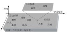
景观系统作为一个可感知的单元(图1),包含大气、土地及生物群落(Rowe, 1961),是个泛地域尺度的多层次水平地域综合体概念的统称,也被称为景观生态系统(王仰麟等, 1999)。可持续的景观系统具有动态稳定的特征,系统整体功能健全与稳定仰赖组成单元功能的提升与结构的优化。气候变化、社会发展、土地利用变化等作为全球变化中的重点议题,其间存在着一定的联系。随着全球变化影响力不断提升,景观系统适应全球变化的结果体现于不同层次水平,适应的单元与方式亦有差异,单一斑块的适应转变或可影响系统整体,系统整体的改变也会影响系统中的个别斑块与廊道。通过对当前景观研究的综合整理,归纳不同景观类型对全球变化的响应,了解当前景观系统适应全球变化的基本特征,将有助基于未来变化趋势,主动改变景观结构与功能,降低突发事件的影响。此外,除积极改变景观结构与功能以主动适应全球变化外,景观系统适应性还可包括被动适应,或按照景观单元和类型划分为独立应对、整体应对。
本文整合农业景观、城市景观等相关研究案例,聚焦景观的主动适应过程,提出景观系统适应全球变化的以下四方面主要特征:
相对于由气候、环境、区位等单一驱动因素的探讨,受全球变化影响,当前的景观格局驱动机制更为复杂。在城市景观研究中,早期注重经济发展导向,除自然环境外,城市景观格局的形成与演变涉及行政区划、经济类型、移民等因素。以中国台湾地区为例,交通通达性是近代城市发展初期主要的驱动因素。在中国大陆,城市规划主导了区域城市景观格局的发展,在深圳市快速的城市扩展过程中,交通路网配置、用地分区方案决定了城市空间格局,而地形、地质与气候条件则成为限制城市景观格局的主要因素(张津等, 2014)。随着城市可持续发展议题的不断深化,城市景观生态学的研究也由单一目标的空间格局优化,转向结合生态系统服务、生态系统健康等开发与保护结合的方向,并延伸出可持续城市、低碳城市、城市生态安全格局等综合理念下的城市景观功能与格局优化架构,并将全球变化视为当前城市景观优化研究的热点议题之一。
在农业景观研究中,气候条件是影响早期农业景观格局与功能的主导因素,而在当前中国农业景观格局变化研究中,农业景观格局不仅取决于自然环境因子,也取决于农业人口密度、农产品价格、比较效益、市场因素和区域农业政策等社会经济因子(刘纪远等, 2009)。气候变化对粮食生产具有一定负面冲击(彭克强, 2008),结合全球变化与作物空间潜力研究成果,可知农作物空间潜力对全球变化过程中的环境、经济和技术因素相对敏感(Liu et al, 2008; 杨晓光等, 2011; Duan et al, 2013; Ye et al, 2014)。以1980年至今的中国水稻种植面积为例,由于自然和社会经济因素综合作用,温度变化、灌溉水平提升和农业经济发展对水稻空间分布皆有重要影响(Li et al, 2015)。
全球变暖作为当前全球变化主要现象,不仅受自然规律影响,同时人类活动中的农业种植及工业生产所产生的温室气体亦加剧了生态环境影响(Gray et al, 2014)。对自然景观而言,全球变暖及密集的人为活动影响直接导致景观与生物多样性降低,自然植被面积的减少与功能退化,使得许多物种由于栖息地丧失与质量下降,种群数量减少或消失(Andrén, 1994; Yu et al, 2017)。在人为景观中,由于长期以来对经济发展需求的过分强调,人为景观中多数景观类型趋同适应相对明显,城市景观及农业景观的大面积复制进而取代了生态景观。农业景观虽基于粮食安全考虑,粮食作物面积得到一定的保障,但许多农业用地在发展过程中已被更高效益的利用方式取代。
经济全球化与城市化带动了城市景观的空间蔓延,对当前的城市景观格局而言,受土地利用规划分区、发展需求等大目标导向影响,城市景观格局呈现出结构组分单一及网格化等特征(李伟峰等, 2005)。随着城市化程度日趋成熟,景观破碎化呈现“快速增加—增速减缓—平稳下降”的过程,上述过程在深圳(曾辉等, 2000)、上海(高峻等, 2001)、福州(林志垒等, 2002)等多个大城市中都有比较典型的表现。以深圳市为例(李卫锋等, 2004),通过景观多样性、破碎度和优势度等景观指数对城市景观格局进行量化,可知区域的社会经济发展带动了土地资源开发,森林、草地及耕地面积的减少导致生态景观及农业景观多样性及优势度降低且破碎化相对明显。
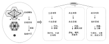
景观是等级系统(Naveh, 2000; 傅伯杰等, 2001),在全球变化的影响下,景观组成单元通过不同等级的分工提高系统整体的适应能力,进而保障区域景观功能。例如,城市景观网络包含了社会、经济功能的景观类型,而社会、经济功能则是通过政治、商业、教育等单元或斑块所构成,由交通路网及基础设施联系;农业景观网络则通过耕地、果园等用地方式体现其生产功能,并由灌溉水渠及河流串连;生态景观网络则通过河流及绿带联系(Cook, 2002; Marsha et al, 2018)。通过不同等级的功能提升与分工重组,可提高并巩固景观整体的健康与稳定。因此,可采用网络来表征景观功能、等级结构与空间联系,在生态网络、城市网络及农业网络等结构中(图2),不同功能导向的景观网络组成结构会因为相互作用而显得复杂。
面对全球变化,景观系统呈现同类景观间功能等级分明、分工明确且具有跨区域的时空联系的特征。城市景观在全球变化的强力驱动下,区域发展已无法仅依赖周边资源与能源,其所需的物质、能源、信息甚至资金,通过全球市场流通,使城市的“生态足迹”或生态占用不再局限于自然或行政界线,城市景观因功能优化的需求,在强化等级结构的同时更拓展至无形的功能关系网。在中国台湾地区,早期地区经济重组的过程将台湾北部区域逐渐融入全球城际网络,而中国大陆的京津冀、长三角等地区也逐渐受到全球经济、文化的影响。当前城市景观单元的功能等级日趋明确,并在全球、区域乃至地方扮演着不同等级的功能中心;而在农业景观格局变化中,影响农民决策的因素也由传统田间土地管理、作物产量目标、经济效益等,扩展至与区域或全球农业经济联系。
在全球变化的驱动下,景观网络等级结构在景观结构与功能优化的研究与应用中亦被广泛利用(Jongman et al, 2004; 焦胜等, 2013)。依托网络的等级结构与跨尺度关联特性,调整关键的景观网络组成单元,整合景观中功能相似或相辅相成的景观结构,有助于应对全球变化冲击,适时进行功能的协调与景观结构的调整,进而维持景观系统稳定,同时提供自然资源与经济资源分配与调度的依据(张小飞等, 2009),达到景观格局优化的目标。
在自然景观结构中,资源斑块的内在异质性有利于抵御环境的干扰,提供抗干扰的恢复性(Forman et al, 1986),从而使景观整体趋向动态稳定(Turner, 1987)。景观过渡带是体现景观功能稳定的特征之一(赵玉涛等, 2002),景观的动态稳定可用来反映景观适应干扰的能力。景观生态学的众多研究证明,过渡带或缓冲带具有较高的生物多样性和景观多样性价值(Fahrig et al, 2011)。但在人为活动主导的土地资源开发利用过程中,土地利用分区是最常见的指导方式,通过功能分区可有效提高土地利用效益,实践亦证明其有助于初期农业、工业和城市的发展。基于部分景观类型间存在功能相互排斥的前提(Mander et al, 1995),通过功能分区可保障人类特定主导经济发展需求的充分满足;但明确的边界造成过渡带或缓冲带整体功能退化,尤其对于区域环境净化、水土保持、气候调节及物种生存等非主导生态系统服务的维持已构成实质冲击。
在全球变化过程中,自然环境的改变与社会经济活动皆是维持景观功能健全与稳定的重要因素。随着城市化进程不断加速,城市边缘区域或生态功能缓冲带随时有可能因为区位或资源因素,转变为城市景观的一部分,进而与相邻的城市联接成为“城市带”或“城市群”,扩展城市景观涵盖范围。针对功能过渡带或缓冲带丧失、生态系统服务功能下降等问题,景观格局优化强调通过结合城市景观生态评估、生物或栖息地相关模型及生态经济系统模型,整合城市内部生态景观单元,包括道路两侧绿带、农田、校园、公园、森林、草地、水域等,从而在变化最小的前提下优化城市区域的景观功能。
基于景观系统结构及功能特征,景观生态适应性研究不仅须关注缓解全球变化对景观系统的冲击,更强调个别景观单元在应对全球变化时发生的转变对系统整体的影响,以及不同景观单元对系统整体发生转变时的时空响应,通过掌握其间的变化趋势与关键环节,明晰全球变化的景观生态适应机制,将景观系统导向可持续发展目标。在全球变化强力作用下,景观系统由于自身的空间分异与尺度间联系所产生的复杂性,景观生态适应性随着时空尺度的差异具有不同的转变单元、规模、强度及方式。在全球变化与景观生态适应性的探讨过程中,就景观系统自身,当前景观生态学研究正尝试回答下述科学问题:①全球变化过程中影响景观生态适应性的关键变量是什么;②景观结构中,哪一种单元、类型正对全球变化进行适应;③景观单元或类型对全球变化的适应过程中,可见的转变与不变的特征是什么;④景观单元或系统对全球变化(风险)的适应方式为何,例如主动适应、被动适应等;⑤上述问题应如何科学合理地进行量化。
在适应性量化方法上,景观生态学者将适应的过程视为景观格局与功能的变化或优化过程,由于景观结构、功能及其间的复杂性与不确定性,适应的过程及其转变趋势相对难以量化,在地域分异与多重影响因子的作用下,景观格局或功能的优化方程多数以非线性特征体现(Nelson et al, 2007; Wilson et al, 2013);同时研究区的选择必须具有一定的典型性,通过大量相似研究区工作的积累,在整合研究区特性的同时,归纳其间适应机制。
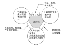
通过适应性视角(图3)可有效地综合归纳气候变化、土地利用变化及人类活动等当前景观系统面临的主要驱动力,结合机理分析、时空格局特征、格局优化方案等显示景观系统应对全球变化过程的适应方式,进而在景观尺度有效地掌握系统整体面临的风险,如自然灾害、水土资源退化与高强度人类活动对不同时空尺度景观格局与过程产生的影响。基于景观系统多层次水平与跨尺度联系的特性,为推动景观系统适应全球变化研究,本文基于当前景观生态适应性认知,建议后续工作重点应关注不同尺度间自上而下及自下而上联系与转变规律的推演,通过量化景观基本类型、单元及系统整体的适应特性,构建基于保障生态系统服务的自上而下跨尺度的适应方案。
(1) 不同景观类型或组成单元的适应能力对比及其不确定性分析
就景观系统而言,不同景观类型、组成单元适应全球变化能力并不相同,在不同时间及空间尺度中亦表现出不同程度的转变,通过分析景观类型与组成单元的转变特征,有助于量化景观系统适应全球变化的响应趋势,进而说明系统整体乃至于不同景观类型或组成单元的适应能力。同时,由于全球变化带来频发的极端气候事件等问题,景观生态研究在尝试归纳适应性特征时,不可避免地面临一定的非线性表现(Pelling et al, 2015),也为景观适应性研究带来许多无法明确量化的议题 (Burgman et al, 2005; Altamirano et al, 2012),例如不同时空尺度适应性的量化、适应性区间的判断、系统自身特性与其适应性限制,乃至其中的不确定性等。不确定性的存在一方面扩展了对景观系统适应范围的理解,另一方面也表明当前案例整理与量化方法的不足。有鉴于此,建议后续工作可对特定景观类型开展全球范围、特定组分局地范围的长时间案例比较研究,以提升对不同景观类型或组成单元的适应能力及其不确定性的认识。
(2) 基于景观系统整体健康的适应途径尺度联系解析
景观健康包含了对环境的影响和响应,景观格局与功能转变,以及社会—经济—自然复合生态系统的整合等内容(曹宇等, 2002)。在面临全球变化带来的环境灾害与风险时,景观适应的理念强调不仅是通过管理与控制,而是基于社会经济发展与生态功能保障目标,通过景观内部各个单元、组分自身的调整与优化,以关键且细微的变化获得未来个体生存、系统整体发展的最大利益。不同尺度的景观适应性存在尺度间的联系,基于特定的功能定位,不同的景观单元可通过自身于景观系统中的重要性与影响力,构建不同层次等级与空间尺度的功能廊道与节点,提出自上而下的优化策略,强化景观系统的适应能力。提升对适应途径尺度联系的理解,有助于在强化景观系统适应能力的同时,降低景观优化的经济成本与对本底环境的干预,如对小流域关键点的植被恢复,可降低流域的泥沙淤积、净化水质,进而提高其生态服务价值。因此,建议后续工作可基于景观系统整体健康视角,解析不同时空单元的环境灾害与风险等级,构建具有尺度联系的分等分级评估方案,作为适应途径的判定依据。
(3) 多学科、多部门在全球变化情景下的有效整合
全球变化的议题包含气候变化、社会发展、经济政策等不同层面,涉及个人、社会乃至全球尺度,甚至包含可预期的未来情景或不可预期的突发性事件,因而景观适应性的探讨包括了跨学科、跨部门相关理论与经验的归纳综合。在人为活动引导下,全球社会经济发展与生态环境问题的关联程度不断提升,景观系统对全球变化的适应取决于多学科、多部门的有效整合。景观格局、功能的优化涉及资源、能源、农业、环境保护、健康风险、教育、交通、社会救助、城乡发展、科技研发及国际合作等多项内容,需要跨区域、多部门及不同研究领域的共同合作。以农业景观为例,其空间格局包含了单一作物的空间分布特征和多种作物组合形成的种植制度特征(唐华俊等, 2009)。在城市景观系统中,当前适应能力主要集中体现在基础设施健全及应急机制完备方面,以应对全球变化过程所带来的相关问题。由于当前的适应能力分析与适应管理的研究中,情景分析或预测是比较常见的方法,可帮助研究者或管理人员了解未来的气候特征、人口结构、农作物产量等情况,进而整合相关的信息,提出可行的处理方案(Karinen et al, 2010; Fuerth, 2011; Goudie, 2013)。对景观系统而言,适应性研究需要了解及掌握气候变化趋势与影响,以降低或改善人类活动对环境的负面影响,同时构建结合文化传承、产业发展、环境净化、气候调节、灾害防范及生境维持等多功能、多目标的土地利用方案,方可提升景观系统对全球变化的适应能力。通过掌握气候变化趋势,辨析特定地区或产业的特性,推导其对气候变化的响应,通过模型模拟探讨其未来状态,进而结合相似地区或相关部门管理与应对措施,强化系统整体应对全球变化的能力。
(4) 景观系统适应性或适应能力量化分析方法的深化
全球变化的趋势及其影响日益显著,当前景观系统的适应性研究仍处于起步阶段,同时,景观系统包括生产力、恢复力、稳定性及其他与适应性相关的特征量化,乃至于社会、经济及文化层面对全球变化的响应研究,仍有进一步提升的空间。适应能力的研究仰赖于长期且持续对全球变化风险不确定性的掌握及系统自身综合能力的提升,通过强化风险发生位置的判定与风险影响量化能力,有助于提升面对全球变化风险的适应能力。由于全球变化过程自身的复杂性与景观系统的多等级、跨尺度的特性,景观系统适应性的辨析需要整合大范围、长时间的趋势分析及突发事件冲击的影响等,加上当前数据精度的提升及数据量的增加,需要更明确的空间制图与更具有指示性的数量方法配合,因而量化分析方法的深化亦是提升景观生态系统适应性的关键因素。
The authors have declared that no competing interests exist.
| [1] |
景观健康概念、特征及其评价 [J].A review on the concept, characteristic and assessment of landscape health [J]. |
| [2] |
中国景观生态学发展历程与未来研究重点 [J].https://doi.org/10.5846/stxb201405040878 URL Magsci [本文引用: 1] 摘要
景观生态学从其诞生到现在,已经历了70余年。中国景观生态学的发展从其引入,到发展、壮大、逐渐成熟,也经历了30余年。在这个发展过程中,中国景观生态学在跟踪国际前沿研究基础上,结合中国实际情况开展了大量研究,在许多研究领域取得了重要进展。简述了国际景观生态学会成立与发展过程,通过系统综述中国景观生态学文献,重点分析了中国景观生态学的发展历程;根据中国景观生态学研究特点,将中国景观生态学发展划分为五个阶段:摸索与酝酿阶段(20世纪80年代以前)、吸收与消化阶段(1980—1988年)、实践与迅速发展阶段(1989—2000)、发展与思索阶段(2001—2010)、思考与创新阶段(2011—?)。在此基础上,重点从土地利用格局与生态过程及尺度效应、城市生态用地与景观安全格局构建、景观生态规划与自然保护区网络优化、森林景观动态模拟与生态系统管理、绿洲景观演变与生态水文过程、景观破碎化与遗传多样性保护、多水塘系统与湿地景观格局设计、稻-鸭/鱼农田景观与生态系统健康、梯田文化景观与多功能维持、源汇景观格局分析与水土流失危险评价等方面系统分析了中国景观生态学研究的特点。最后从学科发展与理论研究、重点研究地区和应用实践三个方面分析了中国景观生态学未来发展的重点方向。
Development history and future research priorities of landscape ecology in China [J].https://doi.org/10.5846/stxb201405040878 URL Magsci [本文引用: 1] 摘要
景观生态学从其诞生到现在,已经历了70余年。中国景观生态学的发展从其引入,到发展、壮大、逐渐成熟,也经历了30余年。在这个发展过程中,中国景观生态学在跟踪国际前沿研究基础上,结合中国实际情况开展了大量研究,在许多研究领域取得了重要进展。简述了国际景观生态学会成立与发展过程,通过系统综述中国景观生态学文献,重点分析了中国景观生态学的发展历程;根据中国景观生态学研究特点,将中国景观生态学发展划分为五个阶段:摸索与酝酿阶段(20世纪80年代以前)、吸收与消化阶段(1980—1988年)、实践与迅速发展阶段(1989—2000)、发展与思索阶段(2001—2010)、思考与创新阶段(2011—?)。在此基础上,重点从土地利用格局与生态过程及尺度效应、城市生态用地与景观安全格局构建、景观生态规划与自然保护区网络优化、森林景观动态模拟与生态系统管理、绿洲景观演变与生态水文过程、景观破碎化与遗传多样性保护、多水塘系统与湿地景观格局设计、稻-鸭/鱼农田景观与生态系统健康、梯田文化景观与多功能维持、源汇景观格局分析与水土流失危险评价等方面系统分析了中国景观生态学研究的特点。最后从学科发展与理论研究、重点研究地区和应用实践三个方面分析了中国景观生态学未来发展的重点方向。
|
| [3] |
|
| [4] |
上海西南城市干道两侧地带景观动态研究 [J].https://doi.org/10.1007/s11769-001-0025-1 URL Magsci [本文引用: 1] 摘要
以上海西南地区多时相的航空遥感图像为主要信息源,建立上海西南地区景观数据库,并在此基础上对1984~1994年上海西南城市干道两侧地带的景观动态进行研究.结果表明,不同功能的道路两侧地带景观演替的速率和规模差异较大,而城市化的作用将导致城市干道逐渐向多种服务方向发展.景观多样性和均匀度从上升到下降的变化,以及景观破碎度逐渐下降,是城市干道两侧地带景观动态的重要标志.
Landscape dynamics of two-side lands-along main urban roads in southwestern Shanghai [J].https://doi.org/10.1007/s11769-001-0025-1 URL Magsci [本文引用: 1] 摘要
以上海西南地区多时相的航空遥感图像为主要信息源,建立上海西南地区景观数据库,并在此基础上对1984~1994年上海西南城市干道两侧地带的景观动态进行研究.结果表明,不同功能的道路两侧地带景观演替的速率和规模差异较大,而城市化的作用将导致城市干道逐渐向多种服务方向发展.景观多样性和均匀度从上升到下降的变化,以及景观破碎度逐渐下降,是城市干道两侧地带景观动态的重要标志.
|
| [5] |
|
| [6] |
景观连通性理论在城市土地适宜性评价与优化方法中的应用 [J].The application of landscape connectivity theory in urban ecology suitability assessment and optimization [J]. |
| [7] |
城市生态系统景观格局特征及形成机制 [J].Landscape pattern and their formation of urban ecosystems [J]. |
| [8] |
深圳市景观格局演变及其驱动因素分析 [J].
在遥感与GIS技术支持下 ,以深圳市域 1978年MSS影像与 1986、1990、1995和 1999年 4期TM影像为主要数据源 ,研究了深圳市域景观的空间格局特征及其动态变化 ,探讨了不同尺度下景观格局演变的驱动因素与变化机制 .结果表明 ,深圳市近 2 0年景观特征发生了深刻变化 ,耕地面积比例由 31 0 6 %下降至 2 6 7% ,城建用地则由 0 33%上升至 2 2 5 2 % .景观多样性指数 1978~ 1995年上升近 2 5 % ,1999年稍有下降 ;蔓延度指数先降后升 ,整体破碎度由 0 0 0 4 2上升到 0 0 0 73;景观修改分维数 1990年以前有所下降 ,2 0世纪 90年代则呈现递增趋势 .景观格局指数的变化 ,反映了人为活动对区域景观特征的深刻影响 .人为活动已成为深圳市景观格局演变的主要驱动因素 .其中 ,斑块形状复杂化主要是受个体经济单元的经济利益驱动 ,景观空间构型的变化取决于产业布局与地域分工的影响 ,景观整体多样性的演变受到社会经济发展水平的强烈影响 ,而自然生态条件则是景观整体结构变化的重要约束因子 .
Landscape spatial changes in Shenzhen and their driving factors [J].
在遥感与GIS技术支持下 ,以深圳市域 1978年MSS影像与 1986、1990、1995和 1999年 4期TM影像为主要数据源 ,研究了深圳市域景观的空间格局特征及其动态变化 ,探讨了不同尺度下景观格局演变的驱动因素与变化机制 .结果表明 ,深圳市近 2 0年景观特征发生了深刻变化 ,耕地面积比例由 31 0 6 %下降至 2 6 7% ,城建用地则由 0 33%上升至 2 2 5 2 % .景观多样性指数 1978~ 1995年上升近 2 5 % ,1999年稍有下降 ;蔓延度指数先降后升 ,整体破碎度由 0 0 0 4 2上升到 0 0 0 73;景观修改分维数 1990年以前有所下降 ,2 0世纪 90年代则呈现递增趋势 .景观格局指数的变化 ,反映了人为活动对区域景观特征的深刻影响 .人为活动已成为深圳市景观格局演变的主要驱动因素 .其中 ,斑块形状复杂化主要是受个体经济单元的经济利益驱动 ,景观空间构型的变化取决于产业布局与地域分工的影响 ,景观整体多样性的演变受到社会经济发展水平的强烈影响 ,而自然生态条件则是景观整体结构变化的重要约束因子 .
|
| [9] |
闽江下游地区景观空间格局及其变化 [J].https://doi.org/10.3969/j.issn.1005-3409.2002.01.032 URL Magsci [本文引用: 1] 摘要
以闽江下游地区为研究实例,运用景观生态学的基本理论与方法,在ARC/INFO和ENVI系统的支持下,选取多样性指数、均匀度、优势度、分离度、破碎化指数和分维数等指标,对该区的景观空间格局进行分析,并分析了1995~2000年期间研究区的景观动态变化情况.
Spatial pattern of landscape in the lower reaches of the Minjiang River and its change [J].https://doi.org/10.3969/j.issn.1005-3409.2002.01.032 URL Magsci [本文引用: 1] 摘要
以闽江下游地区为研究实例,运用景观生态学的基本理论与方法,在ARC/INFO和ENVI系统的支持下,选取多样性指数、均匀度、优势度、分离度、破碎化指数和分维数等指标,对该区的景观空间格局进行分析,并分析了1995~2000年期间研究区的景观动态变化情况.
|
| [10] |
21世纪初中国土地利用变化的空间格局与驱动力分析 [J].https://doi.org/10.3321/j.issn:0375-5444.2009.12.001 URL [本文引用: 1] 摘要
在全球环境变化研究中,以土地利用与土地覆盖动态为核心的人类-环境耦合系统研究逐渐成为土地变化科学(LCS)研究的新动向。基于覆盖中国21世纪初5年间隔的遥感卫星数据获取的1km网格土地利用变化空间信息,依据近5年土地利用变化区域分异的显著特征,以及自然地理、经济发展与国家宏观政策因素综合考虑,设计针对21世纪初5年新的中国土地利用动态区划图,揭示土地利用变化的空间格局与驱动因素。总体上,21世纪初5年中国处于土地利用快速变化期,黄淮海平原、东南沿海地区与四川盆地城乡建设用地显著扩张,占用大规模优质农田,导致南方水田面积明显减少;西北绿洲农业发展与东北地区开垦导致北方旱地面积略有增加;受西部开发"生态退耕"政策的影响中西部地区林地面积显著增加,国家退耕还林还草政策成效明显,对区域土地覆盖状况的改善产生积极的影响;这一时段国土开发与区域发展战略的实施,包括"西部大开发"、"东北振兴"等国家重大政策,加之快速的经济发展是该阶段土地利用变化格局形成的主要驱动因素。
Spatial patterns and driving forces of land use change in China in the early 21st century [J].https://doi.org/10.3321/j.issn:0375-5444.2009.12.001 URL [本文引用: 1] 摘要
在全球环境变化研究中,以土地利用与土地覆盖动态为核心的人类-环境耦合系统研究逐渐成为土地变化科学(LCS)研究的新动向。基于覆盖中国21世纪初5年间隔的遥感卫星数据获取的1km网格土地利用变化空间信息,依据近5年土地利用变化区域分异的显著特征,以及自然地理、经济发展与国家宏观政策因素综合考虑,设计针对21世纪初5年新的中国土地利用动态区划图,揭示土地利用变化的空间格局与驱动因素。总体上,21世纪初5年中国处于土地利用快速变化期,黄淮海平原、东南沿海地区与四川盆地城乡建设用地显著扩张,占用大规模优质农田,导致南方水田面积明显减少;西北绿洲农业发展与东北地区开垦导致北方旱地面积略有增加;受西部开发"生态退耕"政策的影响中西部地区林地面积显著增加,国家退耕还林还草政策成效明显,对区域土地覆盖状况的改善产生积极的影响;这一时段国土开发与区域发展战略的实施,包括"西部大开发"、"东北振兴"等国家重大政策,加之快速的经济发展是该阶段土地利用变化格局形成的主要驱动因素。
|
| [11] |
景观格局与生态过程的耦合途径分析 [J].https://doi.org/10.3969/j.issn.1007-6301.2007.03.001 URL Magsci [本文引用: 1] 摘要
景观生态学自诞生以来在理论和实践方面已经取得了众多进展,然而在景观格局与生态过程关系方面还有很多问题值得深入研究。本文阐述了景观格局和生态过程的有关概念和方法,揭示了其中存在的一些问题和开展耦合研究的必要性,进而总结了耦合研究的一般方法,并在此基础上提出了耦合研究的理论框架,即以一定区域为依托和一定目标为导向进行土地单元或生态系统类型划分,通过土地评价和模型集成将小尺度观测研究和大尺度空间动态模拟相结合,在实现区域目标的基础上,构建具有良好适应性的耦合模型系统。
Analysis of the integrating approach on landscape pattern and ecological processes [J].https://doi.org/10.3969/j.issn.1007-6301.2007.03.001 URL Magsci [本文引用: 1] 摘要
景观生态学自诞生以来在理论和实践方面已经取得了众多进展,然而在景观格局与生态过程关系方面还有很多问题值得深入研究。本文阐述了景观格局和生态过程的有关概念和方法,揭示了其中存在的一些问题和开展耦合研究的必要性,进而总结了耦合研究的一般方法,并在此基础上提出了耦合研究的理论框架,即以一定区域为依托和一定目标为导向进行土地单元或生态系统类型划分,通过土地评价和模型集成将小尺度观测研究和大尺度空间动态模拟相结合,在实现区域目标的基础上,构建具有良好适应性的耦合模型系统。
|
| [12] |
社会-经济-自然复合生态系统 [J].
当代若干重大社会问题,都直接或间接关系到社会体制、经济发展状况以及人类赖以生存的自然环境。社会、经济和自然是三个不同性质的系统,但其各自的生存和发展都受其它系统结构、功能的制约,必须当成一个复合系统来考虑,我们称其为社会-经济-自然复合生态系统。本文分析了该复合系统的生态特征,提出了衡量该复合系统的三个指标:(1)自然系统的合理性;(2)经济系统的利润;(3)社会系统的效益。指出复合生态系统的研究是一个多目标决策过程,应在经济生态学原则的指导下拟定具体的社会目标,经济目标和生态目标,使系统的综合效益最高,风险最小,存活机会最大。文中还提出了一些复合生态系统的研究方向和具体决策步骤。最后给出了三个复合系统的事例。
The social-economic-natural complex ecosystem [J].
当代若干重大社会问题,都直接或间接关系到社会体制、经济发展状况以及人类赖以生存的自然环境。社会、经济和自然是三个不同性质的系统,但其各自的生存和发展都受其它系统结构、功能的制约,必须当成一个复合系统来考虑,我们称其为社会-经济-自然复合生态系统。本文分析了该复合系统的生态特征,提出了衡量该复合系统的三个指标:(1)自然系统的合理性;(2)经济系统的利润;(3)社会系统的效益。指出复合生态系统的研究是一个多目标决策过程,应在经济生态学原则的指导下拟定具体的社会目标,经济目标和生态目标,使系统的综合效益最高,风险最小,存活机会最大。文中还提出了一些复合生态系统的研究方向和具体决策步骤。最后给出了三个复合系统的事例。
|
| [13] |
旱涝灾害视野下中国粮食安全战略研究 [J].Study on China's grain security strategy from the perspective of droughts and floods [J]. |
| [14] |
气候变化科学的最新进展 [J].Latest progress on climate change research [J]. |
| [15] |
|
| [16] |
土地利用/土地覆被变化(LUCC)模型研究进展 [J].Recent progresses of land use and land cover change (LUCC) models [J]. |
| [17] |
景观生态系统的空间结构: 概念、指标与案例 [J].https://doi.org/10.3321/j.issn:1001-8166.1999.03.004 URL Magsci [本文引用: 1] 摘要
空间结构分析是景观生态学研究的重要内容和基本特色之一。讨论了景观生态系统的空间结构概念,提出斑,廓,基,缘是空间结构的四个主要元素。认为对景观生态系统空间结构的分析,可以分三个不同的等级层次进行,一是宏观尺度的整体空间构架,二是中观尺度几种典型的空间组合型;三是空间元素的基本形态特征。
The spatial structure of landscape ecosystems: Concept, indices and case studies [J].https://doi.org/10.3321/j.issn:1001-8166.1999.03.004 URL Magsci [本文引用: 1] 摘要
空间结构分析是景观生态学研究的重要内容和基本特色之一。讨论了景观生态系统的空间结构概念,提出斑,廓,基,缘是空间结构的四个主要元素。认为对景观生态系统空间结构的分析,可以分三个不同的等级层次进行,一是宏观尺度的整体空间构架,二是中观尺度几种典型的空间组合型;三是空间元素的基本形态特征。
|
| [18] |
|
| [19] |
全球气候变暖对中国种植制度可能影响: Ⅵ. 未来气候变化对中国种植制度北界的可能影响 [J].
[目的]气候变化已是一个全球性的问题,中国未来气候将继续变暖,这一变化将对中国的农业生产造成一定的影响.本文旨在研究未来气候变化对中国种植制度北界、冬小麦种植北界、雨养冬小麦-夏玉米稳产种植北界以及热带作物种植北界的影响.[方法]依据全国种植制度气候区划指标、冬小麦种植北界指标、雨养冬小麦-夏玉米稳产种植北界指标以及热带作物种植北界指标,采用经典的农业气候指标计算方法,分析与1950s-1980年相比,未来30年(2011-2040年)及本世纪中叶(2041-2050年)全国种植制度界限北界、冬小麦种植北界、雨养冬小麦-夏玉米稳产的种植北界、以及热带作物的种植北界的变化.[结果](1)与1950s一1980年相比,20112040年和2041-2050年的一年两熟带和一年三熟带种植北界都不同程度向北移动,其中一年一熟区和一年二熟区分界线,空间位移最大的省(市)为陕西省和辽宁省,且2041-2050年种植北界北移情况更为明显;一年两熟区和一年三熟区分界线,空间位移最大的区域在云南省、贵州省、湖北省、安徽省、江苏省和浙江省境内,且2041-2050年种植北移情况更为明显.在不考虑品种变化、社会经济等方面因素的前提下,这些区域由于气温升高种植制度由一年一熟变为一年两熟、由一年两熟变为一年三熟,区域内单位面积周年粮食产量可不同程度提高.(2)与1950s-1980年相比,2011-2040年和2041-2050年的冬小麦的种植北界在辽宁省、甘肃省和宁夏回族自治区都不同程度向北移动,在青海省冬小麦种植界限为西扩明显.在不考虑其它因素影响的前提下,该区域由于冬小麦替代春小麦可带来单位面积产量的提高.热带作物安全种植北界在广西省和广东省境内北移情况比较明显.而未来降水量的增加将使得大部分地区雨养冬小麦-夏玉米稳产种植北界向西北方向移动.[结论]到2011-2040年和2041-2050年,气候变化将会造成全国种植制度界限不同程度北移、冬小麦种植北界北移西扩、热带作物种植北界北移.而未来降水量的增加将使得大部分地区雨养冬小麦-夏玉米稳产种植北界向西北方向移动.
The possible effects of global warming on cropping systems in China: VI. Possible effects of future climate change on northern limits of cropping system in China [J].
[目的]气候变化已是一个全球性的问题,中国未来气候将继续变暖,这一变化将对中国的农业生产造成一定的影响.本文旨在研究未来气候变化对中国种植制度北界、冬小麦种植北界、雨养冬小麦-夏玉米稳产种植北界以及热带作物种植北界的影响.[方法]依据全国种植制度气候区划指标、冬小麦种植北界指标、雨养冬小麦-夏玉米稳产种植北界指标以及热带作物种植北界指标,采用经典的农业气候指标计算方法,分析与1950s-1980年相比,未来30年(2011-2040年)及本世纪中叶(2041-2050年)全国种植制度界限北界、冬小麦种植北界、雨养冬小麦-夏玉米稳产的种植北界、以及热带作物的种植北界的变化.[结果](1)与1950s一1980年相比,20112040年和2041-2050年的一年两熟带和一年三熟带种植北界都不同程度向北移动,其中一年一熟区和一年二熟区分界线,空间位移最大的省(市)为陕西省和辽宁省,且2041-2050年种植北界北移情况更为明显;一年两熟区和一年三熟区分界线,空间位移最大的区域在云南省、贵州省、湖北省、安徽省、江苏省和浙江省境内,且2041-2050年种植北移情况更为明显.在不考虑品种变化、社会经济等方面因素的前提下,这些区域由于气温升高种植制度由一年一熟变为一年两熟、由一年两熟变为一年三熟,区域内单位面积周年粮食产量可不同程度提高.(2)与1950s-1980年相比,2011-2040年和2041-2050年的冬小麦的种植北界在辽宁省、甘肃省和宁夏回族自治区都不同程度向北移动,在青海省冬小麦种植界限为西扩明显.在不考虑其它因素影响的前提下,该区域由于冬小麦替代春小麦可带来单位面积产量的提高.热带作物安全种植北界在广西省和广东省境内北移情况比较明显.而未来降水量的增加将使得大部分地区雨养冬小麦-夏玉米稳产种植北界向西北方向移动.[结论]到2011-2040年和2041-2050年,气候变化将会造成全国种植制度界限不同程度北移、冬小麦种植北界北移西扩、热带作物种植北界北移.而未来降水量的增加将使得大部分地区雨养冬小麦-夏玉米稳产种植北界向西北方向移动.
|
| [20] |
简论人类圈:在地球系统中的作用 [J].https://doi.org/10.3878/j.issn.1006-9895.2009.03.01 Magsci [本文引用: 1] 摘要
工业革命后, 人类活动影响地球环境达到了空前的程度。近年提出的人类世 (anthropocene) 概念就是为表征地球系统演变进入了这一特殊的新纪元。然而, 人类活动并非单向地影响自然, 它在改变自然环境的同时, 环境变化也影响着人类行为, 迫使人类去适应自然变化, 改变生存方式。为更深入地表征人类活动与地球环境相互作用的这种特征, 作者讨论了在地球系统模式里引入“人类圈 (anthroposphere)” 的必要性以及由此带来的新的科学挑战, 并提出了构建包含人类圈的地球系统模式的一些思路。
Anthroposphere: An interactive component in the earth system [J].https://doi.org/10.3878/j.issn.1006-9895.2009.03.01 Magsci [本文引用: 1] 摘要
工业革命后, 人类活动影响地球环境达到了空前的程度。近年提出的人类世 (anthropocene) 概念就是为表征地球系统演变进入了这一特殊的新纪元。然而, 人类活动并非单向地影响自然, 它在改变自然环境的同时, 环境变化也影响着人类行为, 迫使人类去适应自然变化, 改变生存方式。为更深入地表征人类活动与地球环境相互作用的这种特征, 作者讨论了在地球系统模式里引入“人类圈 (anthroposphere)” 的必要性以及由此带来的新的科学挑战, 并提出了构建包含人类圈的地球系统模式的一些思路。
|
| [21] |
深圳市龙华地区快速城市化过程中的景观结构研究: 林地的结构和异质性特征分析 [J].https://doi.org/10.3321/j.issn:1000-0933.2000.03.005 URL Magsci [本文引用: 1] 摘要
利用多时段景观遥感制图信息和景观格局研究方法 ,对深圳市龙华地区快速城市化过程中林地组分的结构特征进行了动态分析 ,重点研究了该组分在 1 988~ 1 996年期间的一般结构特征和空间分布差异的动态变化情况。结果表明研究时段内 ,龙华地区由于快速城市化过程导致林地受到强烈的分割和转化影响 ,总面积损失了 4 9% ,并导致碎裂化、相邻度等景观结构特征发生显著变化。林地的动态变化过程可以分成两个阶段 ,1 988~ 1 992年为大面积林地的碎裂化阶段 ,1 992~ 1 996年为小面积残遗斑块被大量转化阶段 ,最终使原来环绕龙华盆地周围的连续林地分布区域被分割成几个孤立的岛屿。1 988年工作区内林地呈低孔隙度水平的宏观异质性分布 ,1 992年呈随机分布 ,1 996年为高孔隙度水平的宏观异质性分布。研究还表明信息熵法和孔隙度指数可以优势互补 ,二者同时使用有助于全面了解景观异质性细节信息。
Landscape structure study of Longhua area in Shenzhen City during the fast urbanization process: Structure and heterogeneity analysis of forest land [J].https://doi.org/10.3321/j.issn:1000-0933.2000.03.005 URL Magsci [本文引用: 1] 摘要
利用多时段景观遥感制图信息和景观格局研究方法 ,对深圳市龙华地区快速城市化过程中林地组分的结构特征进行了动态分析 ,重点研究了该组分在 1 988~ 1 996年期间的一般结构特征和空间分布差异的动态变化情况。结果表明研究时段内 ,龙华地区由于快速城市化过程导致林地受到强烈的分割和转化影响 ,总面积损失了 4 9% ,并导致碎裂化、相邻度等景观结构特征发生显著变化。林地的动态变化过程可以分成两个阶段 ,1 988~ 1 992年为大面积林地的碎裂化阶段 ,1 992~ 1 996年为小面积残遗斑块被大量转化阶段 ,最终使原来环绕龙华盆地周围的连续林地分布区域被分割成几个孤立的岛屿。1 988年工作区内林地呈低孔隙度水平的宏观异质性分布 ,1 992年呈随机分布 ,1 996年为高孔隙度水平的宏观异质性分布。研究还表明信息熵法和孔隙度指数可以优势互补 ,二者同时使用有助于全面了解景观异质性细节信息。
|
| [22] |
深圳市城市扩展预测与分区评价 [J].Prediction and zoning evaluation of urban sprawl in Shenzhen [J]. |
| [23] |
|
| [24] |
基于功能网络评价的城市生态安全格局研究: 以常州市为例 [J].
基于景观功能网络评价,提出城市复合空间优化方案,并选择常州市为研究区,实证城市生态安全格局理念在空间优化过程中的操作性。由于城市为整合社会、经济与生态功能的复合生态系统,本研究首先依据城市景观功能与结构特征,将城市空间结构分为支持社会经济功能的红色景观,维持能源、资金、产品与信息传播、流通的灰色景观、保持生物多样性与调节区域环境的蓝色景观及绿色景观。其次由功能网络连通性及其相互作用的角度分析城市景观格局、功能流路径与不同功能流在空间上的相互作用,以获得生态功能冲突与环境敏感区域的空间位置。最后,从功能整体协调发展角度,将研究区分为优化开发、调整开发、限制开发及禁止开等分区,针对其存在的生态安全问题,提出符合城市生态安全的空间优化方案。
Study on network analysis for urban ecological security pattern in Changzhou City [J].
基于景观功能网络评价,提出城市复合空间优化方案,并选择常州市为研究区,实证城市生态安全格局理念在空间优化过程中的操作性。由于城市为整合社会、经济与生态功能的复合生态系统,本研究首先依据城市景观功能与结构特征,将城市空间结构分为支持社会经济功能的红色景观,维持能源、资金、产品与信息传播、流通的灰色景观、保持生物多样性与调节区域环境的蓝色景观及绿色景观。其次由功能网络连通性及其相互作用的角度分析城市景观格局、功能流路径与不同功能流在空间上的相互作用,以获得生态功能冲突与环境敏感区域的空间位置。最后,从功能整体协调发展角度,将研究区分为优化开发、调整开发、限制开发及禁止开等分区,针对其存在的生态安全问题,提出符合城市生态安全的空间优化方案。
|
| [25] |
景观异质性研究评述 [J].
通过对国内外大量资料的整理分析,对景观异质性的产生机制、分类、在景观生态学研究中的地位及其测度方法进行了评述.在对景观异质性与景观稳定性、景观规划和管理以及生态学上的干扰、尺度、生物多样性之间相互依存关系论述的基础上,指出了当前景观异质性研究的复杂性、测度方法的不系统性、景观异质性建模在理论与实践上的困难性与局限性,并对生态复杂性研究的理论和方法应用于景观异质性研究进行了展望.
Review on landscape heterogeneity [J].
通过对国内外大量资料的整理分析,对景观异质性的产生机制、分类、在景观生态学研究中的地位及其测度方法进行了评述.在对景观异质性与景观稳定性、景观规划和管理以及生态学上的干扰、尺度、生物多样性之间相互依存关系论述的基础上,指出了当前景观异质性研究的复杂性、测度方法的不系统性、景观异质性建模在理论与实践上的困难性与局限性,并对生态复杂性研究的理论和方法应用于景观异质性研究进行了展望.
|
| [26] |
中国21世纪议程与地理学 [J].China's agenda 21 and geography [J]. |
| [27] |
全球变化的生态系统适应性 [J].https://doi.org/10.3321/j.issn:1001-8166.2004.04.023 URL Magsci [本文引用: 1] 摘要
全球变化的适应性研究已经成为全球变化研究的重点,亦是制定全球变化适应对策的关键.基于全球变化的定义,从生态系统对全球变化适应的4个方面:①对大气CO2浓度变化的适应性;②对气候变化的适应性;③对CO2浓度与气候变化协同作用的适应性;④对人为干扰的适应性,综述了当前的研究成果,进而提出了未来关于全球变化的生态系统适应性研究需要重视的方面,尤其是关于生态系统对全球变化响应的阈值研究应引起高度重视.
Adaptation of terrestrial ecosystems to global change [J].https://doi.org/10.3321/j.issn:1001-8166.2004.04.023 URL Magsci [本文引用: 1] 摘要
全球变化的适应性研究已经成为全球变化研究的重点,亦是制定全球变化适应对策的关键.基于全球变化的定义,从生态系统对全球变化适应的4个方面:①对大气CO2浓度变化的适应性;②对气候变化的适应性;③对CO2浓度与气候变化协同作用的适应性;④对人为干扰的适应性,综述了当前的研究成果,进而提出了未来关于全球变化的生态系统适应性研究需要重视的方面,尤其是关于生态系统对全球变化响应的阈值研究应引起高度重视.
|
| [28] |
Uncertainty in adaptive capacity [J]. |
| [29] |
Uncertainty of landscape indices for spatial structure analysis [J]. |
| [30] |
Effects of habitat fragmentation on birds and mammals in landscapes with different proportions of suitable habitat: A review [J].https://doi.org/10.2307/3545823 URL [本文引用: 1] 摘要
Habitat fragmentation implies a loss of habitat, reduced patch size and an increasing distance between patches, but also an increase of new habitat. Simulations of patterns and geometry of landscapes with decreasing proportion of the suitable habitat give rise to the prediction that the effect of habitat fragmentation on e.g. population size of a species would be primarily through habitat loss in landscape with a high proportion of suitable habitat. However, as the proportion of suitable habitat decreases in the landscape, area and isolation effects start influencing the population size of the species. Hence, the relative importance of pure habitat loss, patch size and isolation are expected to differ at different degrees of habitat fragmentation. This conclusion was supported by a review of studies on birds and mammals in habitat patches in landscapes with different proportions of suitable habitat: the random sample hypothesis was a good predictor of the effects of habitat fragmentation in landscapes with more than 30% of suitable habitat. In these landscapes, habitat fragmentation is primarily habitat loss. However, in landscapes with highly fragmented habitat, patch size and isolation will complement the effect of habitat loss and the loss of species or decline in population size will be greater than expected from habitat loss alone. Habitat patches are parts of the landscape mosaic and the presence of a species in a patch may be a function not only of patch size and isolation, but also of the neighbouring habitat. Habitat generalists may survive in very small patches because they can also utilize resources in the surroundings. Furthermore, the total species diversity across habitats in a given landscape may increase when new patches of habitat are created within the continuous habitat, since new species may be found in these new habitats, even if they are human-made.
|
| [31] |
Local adaptation to temperature conserves top-down control in a grassland food web [J].https://doi.org/10.1098/rspb.2011.0030 URL PMID: 21367789 [本文引用: 1] 摘要
A fundamental limitation in many climate change experiments is that tests represent relatively short-term 'shock' experiments and so do not incorporate the phenotypic plasticity or evolutionary change that may occur during the gradual process of climate change. However, capturing this aspect of climate change effects in an experimental design is a difficult challenge that few studies have accomplished. I examined the effect of temperature and predator climate history in food webs composed of herbaceous plants, generalist grasshopper herbivores and spider predators across a natural 4.8 C temperature gradient spanning 500 km in northeastern USA. In these grasslands, the effects of rising temperatures on the plant community are indirect and arise via altered predator-herbivore interactions. Experimental warming had no direct effect on grasshoppers, but reduced pr茅dation risk effects by causing spiders from all study sites to seek thermal refuge lower in the plant canopy. However, spider thermal tolerance corresponded to spider origin such that spiders from warmer study sites tolerated higher temperatures than spiders from cooler study sites. As a consequence, the magnitude of the indirect effect of spiders on plants did not differ along the temperature gradient, although a reciprocal transplant experiment revealed significantly different effects of spider origin on the magnitude of top-down control. These results suggest that variation in predator response to warming may maintain species interactions and associated food web processes when faced with long term, chronic climate warming.
|
| [32] |
Managing landscapes for conservation under uncertainty [J].https://doi.org/10.1890/04-0906 URL [本文引用: 1] 摘要
In ecology, populations may be linked conceptually with landscapes through habitat and spatial population models. Usually, these models deal with single species and treat a range of uncertainties implicitly and explicitly. They assist managers in testing different management scenarios and making strategic decisions. Landscape pattern analysis was the first attempt to deal with multiple species, and it led to a range of landscape management strategies. Advances in landscape ecology, driven largely by the pragmatic needs of conservation, are building approaches to multispecies management that have stronger ecological foundations. However, their treatment of uncertainty is in its infancy. In this paper, we provide examples to illustrate some of these issues. We conclude that one of the most important sources of uncertainty is the choice of the modeling frame. We recommend that landscape planners use different kinds of models, identify important sources of uncertainty that may affect planning decisions, and seek options that are likely to result in tolerable outcomes, despite uncertainty.
|
| [33] |
Ecological adaptation and mammalian reproduction [J].https://doi.org/10.1021/j100848a076 URL PMID: 5000279 [本文引用: 1] 摘要
Some of the major variations in mammalian reproductive cycles are discussed from the viewpoint of their broad adaptive values. In natural populations a nonpregnant cycle is an exception in long-lived animals and a disaster in short-lived prey species. Acceptable alternatives are either to safeguard agaisnt the occurrence of a nonpregnant cycle or to recover and recycle as quickly as possible. Mammalian female cycles are categorized as Type I Type II and Type III. In Type I both ovulation and pseudopregnancy are spontaneous. Subtype A includes medium length cycles and Subtype B long cycles. In Type II ovulation is induced and pseudopregnancy is spontaneous with the similar subtypes. In Type III both ovulation and corpus luteum formation are spontaneous but pseudopregnancy is induced via the release of luteotropin following copulation. Induced and spontaneous ovulation delayed implantation seasonal breeding and postpartum estrus serve different functions in animals in natural population. It appears that induced ovulation is the more widespread phenomenon and that spontaneous ovulation occurs in a more restricted number of species. Delayed implanatation occurs in widely scattered species and groups within many orders but also the physiological controls vary. At least some degree of seasonality in reproductive activity is almost universal in natural.a Postpartum estrus seems to have developed independently many times and its distribution is sporadic throughout many mammalian speices. The necessity of trying to understand the significance of variations seen in reproductive cycles is stressed. After some basic patterns are established appropriate species can be selected to test some of the hypothesis rather than haphazardly studying forms just because they are available.
|
| [34] |
Landscape structure indices for assessing urban ecological networks [J].https://doi.org/10.1016/S0169-2046(01)00226-2 URL [本文引用: 1] 摘要
Analysis and planning of ecological networks is a relatively new phenomenon and is a response to fragmentation and deterioration of quality of natural systems. In urban areas, the problems of land use intransigence, political and jurisdictional issues create a difficult environment for implementing ecological networks. The specific questions addressed in this research program revolve around the viability of planning an ecological network in an urban landscape. The development and articulation of an ecological network plan was undertaken previously and in this paper, a series of assays of landscape structure are used to examine the viability of an ecological network in the Phoenix, Arizona urban area. Three principal analyses were utilized: (1) patch content analysis, (2) corridor content analysis, and (3) network structure analysis. Patch and corridor content analyses examined the internal characteristic and immediate context for each of the 89 ecological network elements. The network structure analysis incorporates a process for aggregating results of patch and corridor analyses and incorporates indicators that describe interrelationships between landscape elements. For each of these analyses the existing condition was compared to the optimal plan to demonstrate the level of change that can be expected. The results and conclusions of this research are that an ecological network plan provides modest but important improvement in ecological systems in the Phoenix urban area.
|
| [35] |
|
| [36] |
Dynamics of decadal changes in the distribution of double-cropping rice cultivation in China [J].https://doi.org/10.1007/s11434-012-5608-y URL [本文引用: 1] 摘要
对在响应最近的气候变化的稻米饭耕作的分发的变化的量的描述提供一本参考书让米饭耕作模式和反措施的明确的表达在中国应付未来气候变化。这研究基于最大的熵方法在与气候变化的关系在 19612010 期间在中国在双 cropping 米饭的分发分析十的变化的动力学。在双 cropping 米饭耕作区域的十的变化和在中国的气候的适用性是明显的。气候上的全部的区域合适的区域起初最高在 1960 年代,并且随后被看一个增加的趋势然后从 1970 年代的一个减少的趋势到 2000 年代。然而,低气候的适用性区域减少了,它暗示中等、高的气候的适用性区域增加了。在后者之中,高气候的适用性区域证明到 4.4 的程度的最高的增加预定 1990 年代的,四预定 1960 年代的。对气候敏感的大多数改变的双 cropping 米饭耕作的区域主要位于中央江苏,中央安徽,东方四川盆,南部的河南省和中央贵州。在低、中等的气候的适用性之间的区域的转变在北浙江,南部的安徽和湖北被观察,并且北 Guangxi。在中等、高的气候的适用性之间的区域的转变在中央江西和 Leizhou 半岛被观察。在中国的双 cropping 米饭耕作的北边界向南变了并且在 1970 年代向东收缩了,并且在 1980 年代向北延长了。然而,北边界没响应在 2000 年代温暖的气候向北变。
|
| [37] |
Unpacking governance: Building adaptive capacity to climate change of river basins in Brazil [J].https://doi.org/10.1016/j.gloenvcha.2009.07.001 URL [本文引用: 1] 摘要
Governance and institutions are critical determinants of adaptive capacity and resilience. Yet the make-up and relationships between governance components and mechanisms that may or may not contribute to adaptive capacity remain relatively unexplored empirically. This paper builds on previous research focusing on integrated water resources management in Brazil to npack water governance mechanisms that may shape the adaptive capacity of water systems to climatic change. We construct a river basin index to characterize governance approaches in 18 Brazilian river basins, apply a reliability test to assess the validity of these governance indicators, and use in-depth qualitative data collected in a subsample of the basins to explore the relationship between the governance indicators and adaptive capacity. The analysis suggests a positive relationship between integrated water governance mechanisms and adaptive capacity. In addition, we carry out a cluster analysis to group the basins into types of governance approaches and further unveil potential relationships between the governance variables and overall adaptive capacities. The cluster analysis indicates that tensions and tradeoffs may exist between some of the variables, especially with equality of decision making and knowledge availability; a finding that has implications for decision makers aiming to build adaptive capacity and resilience through governance and institutional means.
|
| [38] |
Functional landscape heterogeneity and animal biodiversity in agricultural landscapes [J].https://doi.org/10.1111/j.1461-0248.2010.01559.x URL Magsci [本文引用: 1] 摘要
P>Biodiversity in agricultural landscapes can be increased with conversion of some production lands into 'more-natural'- unmanaged or extensively managed - lands. However, it remains unknown to what extent biodiversity can be enhanced by altering landscape pattern without reducing agricultural production. We propose a framework for this problem, considering separately compositional heterogeneity (the number and proportions of different cover types) and configurational heterogeneity (the spatial arrangement of cover types). Cover type classification and mapping is based on species requirements, such as feeding and nesting, resulting in measures of 'functional landscape heterogeneity'. We then identify three important questions: does biodiversity increase with (1) increasing heterogeneity of the more-natural areas, (2) increasing compositional heterogeneity of production cover types and (3) increasing configurational heterogeneity of production cover types? We discuss approaches for addressing these questions. Such studies should have high priority because biodiversity protection globally depends increasingly on maintaining biodiversity in human-dominated landscapes.
|
| [39] |
Landscape ecology [M]. |
| [40] |
Operationalizing anticipatory governance [J]. |
| [41] |
The human impact on the natural environment: Past present, and future [M]. |
| [42] |
Direct human influence on atmospheric CO2 seasonality from increased cropland productivity [J].https://doi.org/10.1038/nature13957 URL PMID: 25409830 [本文引用: 1] 摘要
Ground- and aircraft-based measurements show that the seasonal amplitude of Northern Hemisphere atmospheric carbon dioxide (CO2) concentrations has increased by as much as 50 per cent over the past 50 years. This increase has been linked to changes in temperate, boreal and arctic ecosystem properties and processes such as enhanced photosynthesis, increased heterotrophic respiration, and expansion of woody vegetation. However, the precise causal mechanisms behind the observed changes in atmospheric CO2 seasonality remain unclear. Here we use production statistics and a carbon accounting model to show that increases in agricultural productivity, which have been largely overlooked in previous investigations, explain as much as a quarter of the observed changes in atmospheric CO2 seasonality. Specifically, Northern Hemisphere extratropical maize, wheat, rice, and soybean production grew by 240 per cent between 1961 and 2008, thereby increasing the amount of net carbon uptake by croplands during the Northern Hemisphere growing season by 0.33petagrams. Maize alone accounts for two-thirds of this change, owing mostly to agricultural intensification within concentrated production zones in the midwestern United States and northern China. Maize, wheat, rice, and soybeans account for about 68 per cent of extratropical dry biomass production, so it is likely that the total impact of increased agricultural production exceeds the amount quantified here.
|
| [43] |
Integrated landscape ecology: A western Australian perspective [J].https://doi.org/10.1016/0006-3207(93)90324-T URL [本文引用: 1] 摘要
The wheatbelt of Western Australia now has severe nature conservation and agricultural problems resulting from rapid and excessive clearing of native vegetation. The landscape is comprised of a large number of small remnants of native vegetation within an agricultural matrix. Currently, different segments of the landscape are managed virtually in isolation, despite the functional interdependence of these elements. Fragmented management of the landscape means that neither conservation problems or agricultural land degradation can be tackled adequately. Similarly, management of conservation networks is rendered difficult. We suggest that management has to be integrated across the landscape, and that complementary strategies can be evolved which simultaneously meet the objectives of conservation and production management
|
| [44] |
|
| [45] |
Assessing adaptability of planted trees using leaf traits: A case study with Robinia pseudoacacia L. in the Loess Plateau, China [J].https://doi.org/10.1007/s11769-011-0470-4 URL [本文引用: 1] 摘要
Leaf trait patterns and their variations with climate are interpreted as an adaptive adjustment to environment.This study assessed the adaptability of planted black locust (Robinia pseudoacacia L.) based on the analysis of leaf traits and the comparison of its leaf traits with inter-specific ones existing in the same area.We measured some water and N use related leaf traits: leaf dry mass per unit area (LMA) and N,P and K concentrations based on both leaf area (Narea,Parea and Karea) and leaf mass (Nmass,Pmass and Kmass) of R.pseudoacacia at 31 sites along a water stress gradient in North Shaanxi Province,China.The results show that leaves of R.pseudoacacia have high Nmass and low LMA in the study area.High Nmass and low LMA are usually representative of luxurious resource use,and will advance plant resource competitiveness in high-resource conditions.As a whole,LMA-nutrient relationships of R.pseudoacacia display patterns that are fairly similar to the inter-specific relationships in both direction and intensity.The tendency for LMA and Narea to increase with decreasing water availability and the positive correlation between LMA and Narea reflect the trend for R.pseudoacacia to enhance water use efficiency (WUE) at the expense of down-regulated photosynthetic N use efficiency (PNUE) and high construction cost in dry conditions.However,the positive relationship between LMA and Narea in high mean annual precipitation (MAP) area is either unremarkable or reversed with decreasing water availability.This implies a lower photosynthetic capacity and a higher construction cost for high-LMA leaves.The inter-specific relationship between LMA and Narea is positive and does not change with water availability.This difference between inter-species and intra-species may be due to more diversified anatomies and more specialised structures for inter-species than intra-species.The failure of R.pseudoacacia adaption to dry conditions reflected by LMA-Narea relationship may be partially responsible for the emergence of rampike and dwarf forms found frequently in dry conditions.Incorporating intrinsic characteristics of planted trees into vegetation restoration project will be instructive and meaningful for species selection.
|
| [46] |
European ecological networks and greenways [J].https://doi.org/10.1016/S0169-2046(03)00163-4 URL [本文引用: 1] 摘要
In the context of European integration, networks are becoming increasingly important in both social and ecological sense. Since the beginning of the 1990s, societal and scientific exchanges are being restructured as the conceptual approaches towards new nature conservation strategies have been renewed. Within the framework of nature conservation, the notion of an ecological network has become increasingly important. Throughout Europe, regional and national approaches are in different phases of development, which are all based on recent landscape ecological principles. Ecological networks are interpreted in a variety of ways depending on different historical roots of nature conservation, planning and scientific traditions, different geographical and administrative levels, different land uses, and in the end the political decision-making is dependent on actors with different land use interests. This complex interaction between cultural and natural features results in quite different ways for the elaboration of ecological networks and greenways.
|
| [47] |
Toward anticipatory governance: The experience with nanotechnology [M] |
| [48] |
|
| [49] |
Chinese rice production area adaptations to climate changes, 1949-2010 [J].https://doi.org/10.1021/es505624x URL PMID: 25625767 [本文引用: 1] 摘要
Climate change has great impact on cropping system. Understanding how the rice production system has historically responded to external forces, both natural and anthropogenic, will provide critical insights into how the system is likely to respond in the future. The observed historic rice movement provides insights into the capability of the rice production system to adapt to climate changes. Using province-level rice production data and historic climate records, here we show that the centroid of Chinese rice production shifted northeastward over 370 km (2.98 N in latitude and 1.88 E in longitude) from 1949 to 2010. Using a linear regression model, we examined the driving factors, in particular climate, behind such rice production movement. While the major driving forces of the rice relocation are such social economic factors as urbanization, irrigation investment, and agricultural or land use policy changes, climate plays a significant role as well. We found that temperature has been a significant and coherent influence on moving the rice center in China and precipitation has had a significant but less spatially coherent influence.
|
| [50] |
A spatially explicit assessment of current and future hotspots of hunger in Sub-Saharan Africa in the context of global change [J].https://doi.org/10.1016/j.gloplacha.2008.09.007 URL [本文引用: 1] 摘要
Hunger knows no boundaries or borders. While much research has focused on undernutrition on a national scale, this report evaluates it at subnational levels for Sub-Saharan Africa (SSA) to pinpoint hotspots where the greatest challenges exist. Undernutrition is assessed with a spatial resolution of 30arc-minutes by investigating anthropometric data on weight and length of individuals. The impact of climate change on production of six major crops (cassava, maize, wheat, sorghum, rice and millet) is analyzed with a GIS-based Environmental Policy Integrated Climate (GEPIC) model with the same spatial resolution. Future hotspots of hunger are projected in the context of the anticipated climate, social, economic, and bio-physical changes. The results show that some regions in northern and southwestern Nigeria, Sudan and Angola with a currently high number of people with undernutrition might be able to improve their food security situation mainly through increasing purchasing power. In the near future, regions located in Ethiopia, Uganda, Rwanda and Burundi, southwestern Niger, and Madagascar are likely to remain hotspots of food insecurity, while regions located in Tanzania, Mozambique and the Democratic Republic of Congo might face more serious undernutrition. It is likely that both the groups of regions will suffer from lower capacity of importing food as well as lower per capita calorie availability, while the latter group will probably have sharper reduction in per capita calorie availability. Special attention must be paid to the hotspot areas in order to meet the hunger alleviation goals in SSA.
|
| [51] |
Nutrient dynamics of riparian ecotones: A case study from the Porijõgi River catchment, Estonia [J]. |
| [52] |
Monitoring riverine thermal regimes on stream networks: Insights into spatial sampling designs from the Snoqualmie River, WA [J].
Understanding, predicting, and managing the spatiotemporal complexity of stream thermal regimes requires monitoring strategies designed specifically to make inference about spatiotemporal variability on the whole stream network. Moreover, monitoring can be tailored to capture particular facets of this complex thermal landscape that may be important indicators for species and life stages of management concern. We applied spatial stream network models (SSNMs) to an empirical dataset of water temperature from the Snoqualmie River watershed, WA, and use results to provide guidance with respect to necessary sample size, location of new sites, and selection of a modeling approach. As expected, increasing the number of monitoring stations improved both predictive precision and the ability to estimate covariates of stream temperature; however, even relatively small numbers of monitoring stations, n聽=聽20, did an adequate job when well-distributed and when used to build models with only a few covariates. In general, winter data were easier to model and, across seasons, mean temperatures were easier to model than summer maximums, winter minimums, or variance. Adding new sites was advantageous but we did not observe major differences in model performance for particular new site locations. Adding sites from parts of the river network with thermal regimes which differed from the rest of the network, and which were therefore highly influential, improved nearby predictions but reduced model-estimated precision of predictions in the rest of the network. Lastly, using models which accounted for the network-based spatial correlation between observations made it much more likely that estimated prediction confidence intervals covered the true parameter; the exact form of the spatial correlation made little difference. By incorporating spatial structure between observations, SSNMs are particularly valuable for accurate estimation of prediction uncertainty at unmeasured locations. Based on our results, we make the following suggestions for designing water temperature monitoring arrays: (1) make use of pilot data when possible; (2) maintain a distribution of monitors across the stream network (i.e., over space and across the full range of covariates); (3) maintain multiple spatial clusters for more accurately estimating correlation of nearby sites; (4) if sites are to be added, prioritize capturing a range of covariates over adding new tributaries; (5) maintain a sensor array in winter; and (6) expect reduced accuracy and precision when predicting metrics other than means.
|
| [53] |
What is holistic landscape ecology? A conceptual introduction [J].https://doi.org/10.1016/S0169-2046(00)00077-3 URL [本文引用: 1] 摘要
To meet the challenges of the emerging information-rich society, landscape ecology must become a holistic problem-solving oriented science by joining the transdisciplinary scientific revolution with a paradigm shift from conventional reductionistic and mechanistic approaches to holistic and organismic approaches of wholeness, connectedness and ordered complexity. Its central holistic concept is the Total Human Ecosystem as the highest level of co-evolutionary complexity in the global ecological hierarchy, with solar energy powered biosphere and fossil energy powered technosphere landscapes as its concrete systems. Landscape ecology could contribute to their structural and functional integration into a coherent sustainable ecosphere and thereby to the establishment of a sustainable balance between attractive and productive biosphere landscapes and healthy and livable technosphere landscapes for this and future generation. By utilizing new insights in self-organization of autopioetic systems and their cross-catalytic networks in the Total Human Ecosystem for synergistic benefits of the people, their economy and landscapes, such holistic landscape ecology together with other mission-driven transdisciplinary environmental sciences could serve as a catalyst for the urgently needed post-industrial symbiosis between nature and human society. This would ensure also their further biological and cultural evolution.
|
| [54] |
Adaptation to environmental change: Contributions of a resilience framework [J].https://doi.org/10.1146/annurev.energy.32.051807.090348 URL [本文引用: 2] 摘要
Adaptation is a process of deliberate change in anticipation of or in reaction to external stimuli and stress. The dominant research tradition on adaptation to environmental change primarily takes an actor-centered view, focusing on the agency of social actors to respond to specific environmental stimuli and emphasizing the reduction of vulnerabilities. The resilience approach is systems orientated, takes a more dynamic view, and sees adaptive capacity as a core feature of resilient social-ecological systems. The two approaches converge in identifying necessary components of adaptation. We argue that resilience provides a useful framework to analyze adaptation processes and to identify appropriate policy responses. We distinguish between incremental adjustments and transformative action and demonstrate that the sources of resilience for taking adaptive action are common across scales. These are the inherent system characteristics that absorb perturbations without losing function, networks and social capital that allow autonomous action, and resources that promote institutional learning.
|
| [55] |
Loss of water availability and stream biodiversity under land abandonment and climate change in a Mediterranean catchment (Olzinelles, NE Spain) [J].https://doi.org/10.1016/j.landusepol.2010.06.002 URL Magsci [本文引用: 1] 摘要
In the north rim of the Mediterranean region, where forest cover is increasing as a result of land abandonment and temperatures are rising as a result of climate change, there is increasing interest for the effects of such changes on the runoff of water courses. This is a paramount issue for the conservation of many freshwater habitats and species. In this work we studied the effects of both an increase in forest cover after depopulation and land abandonment and an increase in temperature on the runoff of a Mediterranean catchment and on the aquatic and semi-aquatic fauna species of the stream (Olzinelles valley, NE Spain). Although in our simulation no decreasing trend in runoff is detected, the monthly runoff-rainfall ratio is now 15% lower than 30 years ago, a fact that may be attributed to a drier period rather than to the small afforestation experienced by the catchment in the last decades. Other factors such as increasing temperatures, changing rainfall patterns and increasing canopy cover are discussed. The observed decrease in the water flow has caused the disappearance of white-clawed crayfish ( Austropotamobius pallipes ), Mediterranean barbel ( Barbus meridionalis ), chub ( Squalius cephalus ), European eel ( Anguilla anguilla ), and southern water vole ( Arvicola sapidus ). Our results suggest that in a progressively warmer climate, and especially after land abandonment processes, management of Mediterranean mountain areas should be oriented towards an appropriate distribution of agrarian and forest land-covers in terms of water availability. Down to the stream scale, the pools that keep water throughout the year should be conserved and extended to enhance its potential to maintain aquatic and semi-aquatic species populations.
|
| [56] |
Adaptation and transformation [J]. |
| [57] |
The impacts of climate change on water resources and agriculture in China [J].https://doi.org/10.1038/nature09364 URL PMID: 20811450 [本文引用: 1] 摘要
Abstract China is the world's most populous country and a major emitter of greenhouse gases. Consequently, much research has focused on China's influence on climate change but somewhat less has been written about the impact of climate change on China. China experienced explosive economic growth in recent decades, but with only 7% of the world's arable land available to feed 22% of the world's population, China's economy may be vulnerable to climate change itself. We find, however, that notwithstanding the clear warming that has occurred in China in recent decades, current understanding does not allow a clear assessment of the impact of anthropogenic climate change on China's water resources and agriculture and therefore China's ability to feed its people. To reach a more definitive conclusion, future work must improve regional climate simulations-especially of precipitation-and develop a better understanding of the managed and unmanaged responses of crops to changes in climate, diseases, pests and atmospheric constituents.
|
| [58] |
The level-of-integration concept and ecology [J].https://doi.org/10.2307/1932098 URL [本文引用: 1] 摘要
CiteSeerX - Scientific documents that cite the following paper: The Level-of-Integration Concept and Ecology
|
| [59] |
Effects of wildfire on catchment runoff response: A modelling approach to detect changes in snow-dominated forested catchments [J].https://doi.org/10.2166/nh.2010.036 URL [本文引用: 1] 摘要
Wildfire is an important disturbance affecting hydrological processes through alteration of vegetation cover and soil characteristics. The effects of fire on hydrological systems at the catchment scale are not well known, largely because site specific data from both before and after wildfire are rare. In this study a modelling approach was employed for change detection analyses of one such dataset to quantify effects of wildfire on catchment hydrology. Data from the Entiat Experimental Forest (Washington State, US) were used, a conceptual runoff model was applied for pre- and post-fire periods and changes were analyzed in three different ways: reconstruction of runoff series, comparison of model parameters and comparison of simulations using parameter sets calibrated to the two different periods. On average, observed post-fire peak flows were 120% higher than those modelled based on pre-fire conditions. For the post-fire period, parameter values for the snow routine indicated deeper snow packs and earlier and more rapid snowmelt. The net effect of the changes in all parameters was largely increased post-fire peak flows. Overall, the analyses show that change detection modelling provides a viable alternative to the paired-watershed approach for analyzing wildfire disturbance effects on runoff dynamics and supports discussions on changes in hydrological processes.
|
| [60] |
Adaptation options in agriculture to climate change: A typology [J].https://doi.org/10.1023/A:1015862228270 URL Magsci [本文引用: 1] 摘要
<a name="Abs1"></a>Adaptation in agriculture to climate change is important for impact andvulnerability assessment and for the development of climate change policy. A wide variety of adaptation options has been proposed as having thepotential to reduce vulnerability of agricultural systems to risks related toclimate change, often in an <i>ad hoc</i> fashion. This paper develops atypology of adaptation to systematically classify and characterize agriculturaladaptation options to climate change, drawing primarily on the Canadiansituation. In particular, it differentiates adaptation options in agricultureaccording to the involvement of different agents (producers, industries,governments); the intent, timing and duration of employment of theadaptation; the form and type of the adaptive measure; and the relationshipto processes already in place to cope with risks associated with climatestresses. A synthesis of research on adaptation options in Canadianagriculture identifies four main categories: (i) technological developments,(ii) government programs and insurance, (iii) farm production practices,and (iv) farm financial management. In addition to these `directadaptations', there are options, particularly information provision, that maystimulate adaptation initiatives. The results reveal that most adaptationoptions are modifications to on-going farm practices and public policydecision-making processes with respect to a suite of changing climatic(including variability and extremes) and non-climatic conditions (political,economic and social). For progress on implementing adaptations to climatechange in agriculture there is a need to better understand the relationshipbetween potential adaptation options and existing farm-level andgovernment decision-making processes and risk management frameworks.
|
| [61] |
Adaptation, adaptive capacity and vulnerability [J].https://doi.org/10.1016/j.gloenvcha.2006.03.008 URL [本文引用: 1] 摘要
This paper reviews the concept of adaptation of human communities to global changes, especially climate change, in the context of adaptive capacity and vulnerability. It focuses on scholarship that contributes to practical implementation of adaptations at the community scale. In numerous social science fields, adaptations are considered as responses to risks associated with the interaction of environmental hazards and human vulnerability or adaptive capacity. In the climate change field, adaptation analyses have been undertaken for several distinct purposes. Impact assessments assume adaptations to estimate damages to longer term climate scenarios with and without adjustments. Evaluations of specified adaptation options aim to identify preferred measures. Vulnerability indices seek to provide relative vulnerability scores for countries, regions or communities. The main purpose of participatory vulnerability assessments is to identify adaptation strategies that are feasible and practical in communities. The distinctive features of adaptation analyses with this purpose are outlined, and common elements of this approach are described. Practical adaptation initiatives tend to focus on risks that are already problematic, climate is considered together with other environmental and social stresses, and adaptations are mostly integrated or mainstreamed into other resource management, disaster preparedness and sustainable development programs.
|
| [62] |
Spatial simulation of landscape changes in Georgia: A comparison of 3 transition models [J].https://doi.org/10.1007/BF02275263 URL [本文引用: 1] 摘要
Spatial simulation models were developed to predict temporal changes in land use patterns in a piedmont county in Georgia (USA). Five land use categories were included: urban, cropland, abandoned cropland, pasture, and forest. Land use data were obtained from historical aerial photography and digitized into a matrix based on a 1 ha grid cell format. Three different types of spatial simulation were compared: (1) random simulations based solely on transition probabilities; (2) spatial simulations in which the four nearest neighbors (adjacent cells only) influence transitions; and (3) spatial simulations in which the eight nearest neighbors (adjacent and diagonal cells) influence transitions. Models and data were compared using the mean number and size of patches, fractal dimension of patches, and amount of edge between land uses. The random model simulated a highly fragmented landscape having numerous, small patches with relatively complex shapes. The two versions of the spatial model simulated cropland well, but simulated patches of forest and abandoned cropland were fewer, larger, and more simple than those in the real landscape. Several possible modifications of model structure are proposed. The modeling approach presented here is a potentially general one for simulating human-influenced landscapes.
|
| [63] |
Separating adaptive maintenance (resilience) and transformative capacity of social-ecological systems [J].https://doi.org/10.5751/ES-05100-180122 URL [本文引用: 1] 摘要
Many rural communities are vulnerable social-ecological systems (SES) that must do more than become resilient to future environmental and social shocks: they must transform to achieve sustainability. We aimed first to conceptually explore the proposition that SES characteristics (identity, feedbacks, structure, and functions) necessary for transformation may be distinct from those necessary for adaptive maintenance or resilience, and second, to propose metrics that may be used to assess these two types of system changes. We did this by interrogating literature and by investigating two rural towns in Australia using a combination of quantitative methods and focus groups to interrogate community social networks, capitals (human, natural, built, and social) and future scenarios. Results indicated that (1) it is practicable to carry out a holistic assessment of SES characteristics (identity, feedbacks, structure, and functions), and (2) purposeful, positive transformation is supported by vision, identification with place, unhappiness (with the status quo), high personal contribution to social capital, open social networks, and latent capital(s). We conclude that rural communities possess capacities for adaptive maintenance (resilience) and for system-wide transformation, and that the metrics used to assess each are sometimes discrete, sometimes common.
|
| [64] |
The effects of climate change on the planting boundary and potential yield for different rice cropping systems in Southern China [J].https://doi.org/10.1016/S2095-3119(14)60809-1 URL [本文引用: 1] |
| [65] |
Establishment of a comprehensive indicator system for the assessment of biodiversity and ecosystem services [J].https://doi.org/10.1007/s10980-017-0549-0 URL [本文引用: 1] 摘要
Common indicators are needed to monitor biodiversity loss and the implications for the sustainable provision of ecosystem services (ES). A plethora of different sets of indicators may hinder the ident
|
| [66] |
The new world of the anthropocene [J].https://doi.org/10.1021/es903118j URL PMID: 20184359 [本文引用: 1] 摘要
The Anthropocene, following the lost world of the Holocene, holds challenges for both science and society.
|

/
| 〈 |
|
〉 |