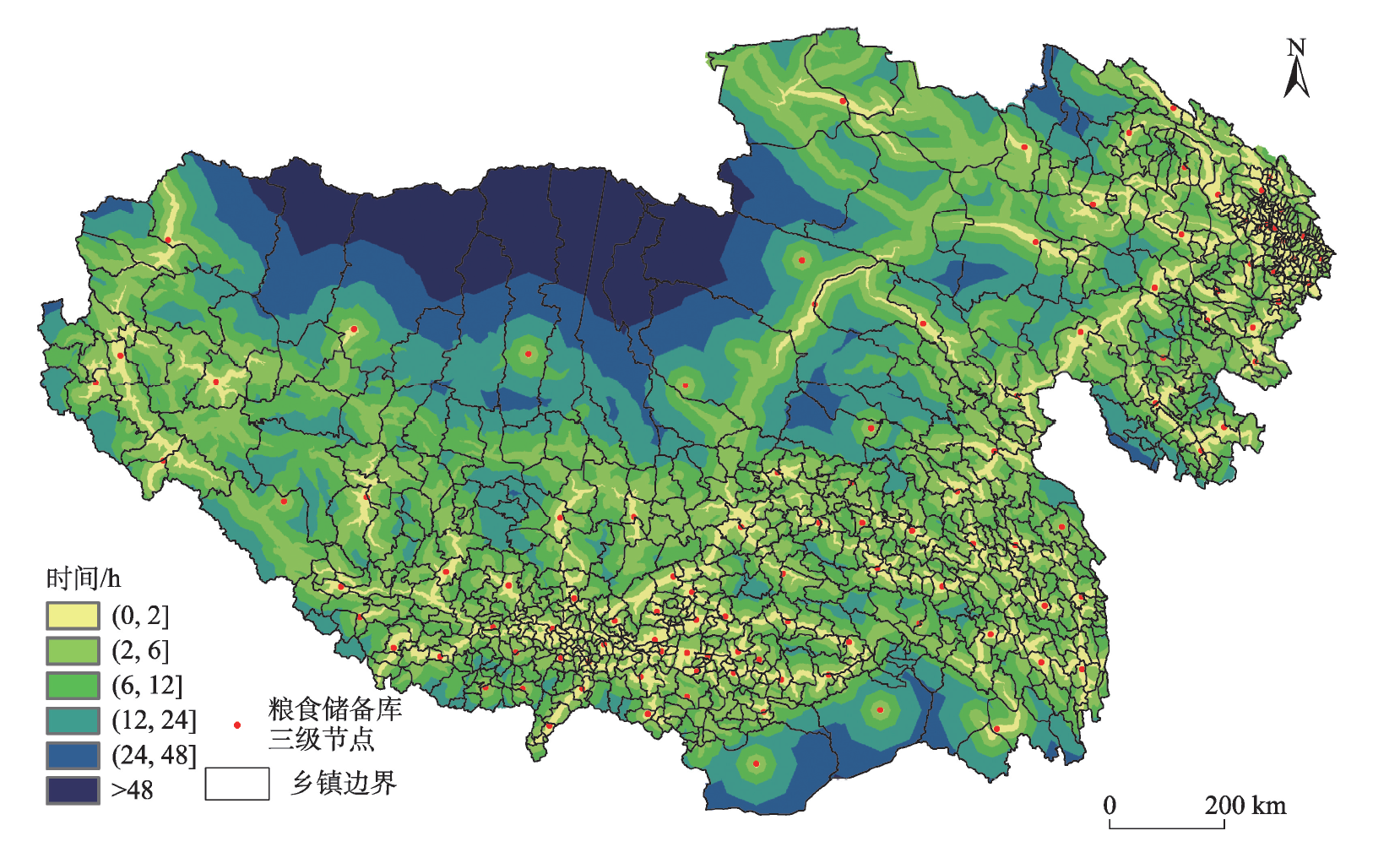
Government grain reserves are the ballast for national food security, and local government grain reserves are the first line of defense to safeguard national food security and market stability. Bordering India, Nepal, Bhutan, Myanmar, and the Kashmir region, the Qinghai-Tibet Plateau is China's strategic front for national defense, and it is of great significance to examine the scale and spatial distribution of grain reserves on the Qinghai-Tibet Plateau. This study proposed a demand-based method to measure the scale of grain reserves. Considering the grain storage conditions and the characteristics of grain production and consumption on the Qinghai-Tibet Plateau, we applied the model and revised the key parameters to calculate the scale of grain reserves on the plateau. On this basis and using the road network analysis method, we further discussed the spatial location of grain storage infrastructures. The results show that: 1) The total scale of required grain reserves on the Qinghai-Tibet Plateau was about 815100 t, which was equivalent to 24.04% of the total annual grain consumption, and the ratio of grain reserves to consumption was higher than the minimum safe level recommended by the Food and Agriculture Organization of the United Nations (FAO), which is 17%-18%. 2) Grain production, consumption, and reserves on the Qinghai-Tibet Plateau were unbalanced. Only 27.19% of the counties could achieve a balance between grain production, consumption, and storage, and most counties had grain shortages. 3) The total grain deficit on the Qinghai-Tibet Plateau was about 1.82 million t, and the grain deficit in agricultural areas, pastoral areas, and semi-agricultural and semi-pastoral areas were 1.24 million t, 331600 t, and 241400 t, respectively. 4) The grain storage infrastructure system on the Qinghai-Tibet Plateau consisted of three vertical levels: two first-level nodes (Xining and Lhasa), 15 second-level nodes, and 114 third-level nodes. 5) In reality, the scale of local grain reserves on the Qinghai-Tibet Plateau was 26.39% lower than the theoretical value. Therefore it is urgent to further increase the scale of local grain reserves. The results can provide policy references for the reform of the grain reserve system in Tibet and Qinghai.
The impact of infrastructure development on ecological landscapes is an area that needs urgent attention under the multidisciplinary turn of thought in geography. It is not only closely related to the practice of the Chinese path to modernization, but also involves changes in geospatial patterns, which in turn affect the development of human society. This study used road data from 2010-2020 in the Tibet Autonomous Region to interactively examine the spatial relationship between road accessibility improvement and changes in landscape fragmentation from both the global and local dimensions at the township scale. The study showed that: 1) The total mileage of roads in the Tibet Autonomous Region (TAR) nearly doubled from 2010 to 2020, with a significant improvement in accessibility. 2) The construction of the road network intensified landscape fragmentation and had some negative impacts on the ecological environment, but the spatial differentiation was obvious. 3) For every 1% increase in highway global accessibility, the landscape fragmentation along the road increased by 0.20%, and for every 1% increase in highway local accessibility, the landscape fragmentation increased by 0.16%. The correlation between accessibility improvement and landscape fragmentation in spatial distribution was small. The results of the study are instructive for further promoting the comprehensive trade-off between accessibility and landscape ecological impacts in future highway planning and construction in the Tibet Autonomous Region.
Qinghai Province is an important part of the Qinghai-Tibet Plateau and an important inhabited area of ethnic minorities. It is of high practical significance to study the spatial equity and efficiency of the allocation of medical resources in this province and provide references for optimizing the distribution of medical resources. Based on population and medical resource data, this study used the cost grid method to evaluate the population-weighted accessibility to medical treatments at the district/county scale in Qinghai Province. Combining the data of the number of healthcare personnel and medical expenditure input, this study used Gini coefficient and data envelopment analysis to evaluate the spatial equity and efficiency of medical resources in the province. The results show that the values of Gini coefficient of the number of healthcare personnel, the number of hospitals, the number of beds in hospitals, and medical expenditure in Qinghai Province were all less than 0.3, which was relatively equal, while the Gini coefficient of the population-weighted accessibility for medical services was 0.6546, showing considerable regional differences. The spatial equity of medical resources at the population level is better than that at the spatial level. The result of data envelopment analysis shows that both the comprehensive efficiency and the scale efficiency are 1 in 18 districts/counties in Qinghai Province, where the optimal allocation of medical resources has been achieved. The districts/counties not achieving the value of 1 are generally of the type of decreasing scale efficiency, where investment needs to be increased. The spatial equity and efficiency evaluation method of medical resources established in this study can serve the spatial planning of medical resources in Qinghai Province and provide a scientific basis for promoting the equalization of medical services.
Livability evaluation and analysis of its influencing factors from the perspective of residents is a prerequisite for improving the livability level and enhancing the well-being of people living in agricultural and pastoral areas. It has important value for the healthy development of human-environment relationship in the these areas. In this study, we constructed a perception indicator system for the livability of agricultural and pastoral residents on the Qinghai-Tibet Plateau, including four primary indicators—infrastructure, environmental sanitation facilities, social services, and policy support—as well as 12 secondary indicators. Based on a questionnaire survey of 877 farming and herding households, we described the perception characteristics of livability and used a structural equation model to quantitatively measure the influencing factors of livability perception from the demand side of the subjects and the supply side externally. The results show that: 1) The satisfaction level of livability among agricultural and pastoral residents in Qinghai Province is moderate, and the satisfaction level of herders (60.83%) is higher than that of farmers (55.78%). The satisfaction level of elements decreases in the following order: policy support, environmental sanitation facilities, social services, and infrastructure. 2) The perception of livability among agricultural and pastoral residents on the Qinghai-Tibet Plateau is influenced by a combination of factors such as transportation, public services, and household characteristics. Factors such as family health status and ethnic attributes have a significant impact on livability perception. Both transportation and public services have a significant positive impact on livability perception, and transportation indirectly affects livability perception through the mediating variable of public services. 3) Public services and transportation have a positive impact on livability perception in both farming and herding households, but the degree of influence differs. Farming households are influenced by factors such as drinking water supply facilities, express delivery and logistics services, and basic education services, while herding households are more sensitive to factors such as express delivery and logistics services, domestic sewage disposal facilities, power supply facilities, and communication network facilities. The results of the study can provide scientific references for improving the perception of livability of farmers and herders and realizing the sustainable development of the human-environment system in the plateau agricultural and pastoral areas.
Examining the effects of household energy transition and its influencing factors in ethnic minority areas on the Tibetan Plateau is of great significance for promoting the high-quality development of ethnic minority areas and improve the well-being of local residents. Based on field surveys and semi-structured interviews, this study investigated the energy consumption behavior of 1188 households in eight cities (prefectures) of Qinghai Province, and identified the characteristics of household energy transition effects in urban and rural areas of Qinghai Province, the Hehuang valley area of eastern Qinghai Province, the lake area and the Tsaidam Basin area, and the pastoral area of southern Qinghai Province from two aspects of regional clean energy penetration rate and household energy cleanliness degree. A multiple Logistic regression model was used to analyze the influencing factors of household energy cleanliness. The results show that: 1) There is a significant difference in household clean energy penetration rate between urban and rural areas. About 50% of the surveyed households in urban areas mainly use modern clean energy, while household energy consumption in rural areas is in urgent need of transformation. 2) There are some differences in household clean energy use among the three regions. The penetration rate of modern clean energy in the Hehuang valley of eastern Qinghai Province and the lake area and the Tsaidam Basin area has reached 100%, while the energy transition in the pastoral areas of southern Qinghai Province needs to be accelerated. 3) For lighting, cooking, and heating, about 77.3% of the households in the study area use clean energy, while no more than 5% of the households do not use modern clean energy. 4) Characteristics of household members, location, cognitive level of household members, climate conditions, and ethnic group characteristics all affect the degree of household energy cleanliness. In order to promote the household energy transition in the study area, we should pay attention to the regional differences of households, attach high importance to the guidance of household members' cognition and behavior, and strengthen the attention to and support for the clean energy transition of ethnic minority families.
The main threat to the natural ecosystem in the alpine ecological functional zone is the discharge of domestic waste from residential areas. However, the waste collection and transfer system of the current domestic waste management model is weak and unable to adapt to the decentralized nature of urban and rural settlements and waste generation characteristics, and it is critical to form a zero-threat, equal, and low-cost waste collection and transfer system in the alpine ecological functional zone based on spatiotemporal route optimization and flexible adaptation. In this study, an improved ant colony algorithm was used to simulate the optimal spatiotemporal route arrangements and develop a flexible management model of the waste collection and transfer system, which was based on a survey of daily domestic waste generation and the estimation of collection and transfer scale in Milin County, a forested area on the southeastern edge of the Tibetan Plateau. The results show that: 1) The daily generation of domestic waste in Milin County is 1.60, 0.48, and 0.25 kg/d per capita, respectively, for urban residents, farmers, and herders; and the current "collection by village, transfer by town, and treatment by county" system in the alpine ecological functional zone shows the characteristics of low treatment efficiency, high economic costs, and high environmental risk. 2) The improved ant colony algorithm can effectively optimize the transportation route of the domestic waste collection and transfer system while dynamically adjusting the collection and transfer cycle by considering the amount of residents' domestic waste generation, which will significantly improve the transportation efficiency and reduce the cost of the domestic waste collection and transfer system in the alpine ecological functional zone. The total distance of domestic waste transport after the spatiotemporal optimization of routes is 28.53% less than before, and the economic cost is 10.45% lower. 3) The flexible adaptation capacity and response to risks of the domestic waste collection and transfer systems in the alpine ecological functional zone should be strengthened under the optimal spatiotemporal route, with emphasis on on-site classification, peak response, cycle regulation, and risk control. The results of the study clarified the spatial and temporal optimization and adaptive management scheme of the domestic waste collection and transport system in the county area, which can provide a reference for the improvement of the human settlement environment and prevention of environmental risks in the ecological functional zone.
The relationship between urbanization and ecosystem services is an important issue in the field of sustainable development. The relationship between human activities and the ecological environment has increasingly shifted from passive adaptation to active coordination as human potential to transform nature under unique geographical conditions such as on plateaus has been strengthened. Promoting the coordination of economic and social development (represented by urbanization) and ecosystem services (assessed by the value of ecological assets) in plateau areas is increasingly becoming critical for achieving the objective of sustainable regional development. Taking Tibet Autonomous Region as the research area, this study measured the comprehensive level of urbanization and ecosystem services from 2000 to 2020. The research methods included bivariate spatial autocorrelation, a coupling and coordination degree model, and kernel density estimation. The purpose of this study was to explore the multi-scale spatial correlation characteristics of urbanization and ecosystem services, and to identify the coupling and coordination types and spatiotemporal evolution modes of these two systems. The results are as follows: 1) Urbanization in Tibet between 2000 and 2020 displayed the spatial distribution characteristics of local agglomeration, and the overall trend of interannual change was a steady increase. The spatial distribution of ecosystem services, on the other hand, was more dispersed with significant regional disparities, but the overall level remained consistent. 2) There was a significant negative spatial correlation between urbanization and ecosystem services. The level of ecosystem services in the surrounding areas of places with high comprehensive urbanization index values was comparatively low. 3) The connection between urbanization and ecosystem services in Tibet first grew and then weakened, with 2010 as the transition point. Currently, coordinated development is the predominant form, but there are some areas that are at risk of deterioration in coordination. 4) The spatial transformation from single-center dominance in Lhasa and its surrounding areas to a multi-center distribution mode including other cities, districts, and counties, was reflected in the evolution of coupling and coordination relationships and benefited to some extent from the spatial spillover effect of the coupling and coordination development process in Lhasa. This work completes the study on the spatial coupling and coordination of urbanization and ecosystem services on the plateau and provides a decision-making basis for guiding the coordinated and healthy growth of human-environment relationships.
As an important ecosystem service function, natural landscape aesthetics has great impact on human health and well-being, which is a prerequisite for nature-based tourism and national park construction activities. At present, although some landscape planning and decision making, such as developing national parks, are carried out on a regional scale, the existing research lacks the evaluation of the landscape aesthetic value on the regional scale. From the perspective of ecosystem services and based on an examining of the landscape naturalness, diversity, and uniqueness dimensions, this study evaluated the natural landscape aesthetic value (NLAV) in Tibet at the regional scale. The results show that the areas with low, relatively low, medium, relatively high, and high NLAV in Tibet accounted for 12.2%, 20.2%, 32.4%, 21.4% and 13.8%, respectively. Natural landscape aesthetic values showed significant regional differences, with an overall distribution pattern of high in the southeast and low in the northwest. The high value areas are concentrated in the eastern part of the Himalayas and the Hengduan Mountains in eastern Tibet, the Qomolangma region in the middle of the Himalaya Mountains, and the Qiangtang Plateau region in northern Tibet. The low value areas are mainly distributed in the Naqu-Ngari Plateau alpine desert steppe and arid desert region, and widely dispersed in the central and eastern parts of Tibet. The impacts of diversity, naturalness, and uniqueness on the NLAV in Tibet are in a decreasing order. Among the four national park candidates in Tibet, Zangbo Grand Canyon has the highest NLAV, while Kailash Pozi and Changtang are relatively low. The results of this study provide useful references for the spatial evaluation of large-scale landscape values, as well as the construction of national parks, landscape planning and management, and ecological protection on the Qinghai-Tibet Plateau.
Understanding the spatiotemporal distribution and causes of grassland fires is of great importance for maintaining the ecological barrier function, sustainable development of animal husbandry, and disaster risk management on the Qinghai-Tibet Plateau. In this study, taking Qinghai Province, China as the study area, the spatiotemporal distribution patterns and causes of grassland fires were analyzed based on historical fire data and MODIS fire trails product MCD64A1 from 2002 to 2020, using the kernel density estimation method. The results indicate that: 1) Grassland fires in Qinghai Province showed a pattern of more in the east and less in the west; and Zeku, Guinan, and Henan cunties had the highest number of grassland fires. Grassland types and human activities dominated this spatial pattern, and grassland types played a major role, while human activities were important triggering factors—alpine meadows within 1 km of roads and settlements were the high incidence areas. 2) With the increase of wildfire sources, the frequency of grassland fires identified by remote sensing and historical fire data showed a fluctuating upward trend in Qinghai Province from 2002 to 2020, but the average fire area was gradually decreasing. It indicates that the fire extinguishing ability was constantly improving. The frequency of grassland fires showed clear bimodal seasonal characteristics—fires were most frequent in late autumn and winter, followed by spring, and relatively rare in summer. 3) High-voltage line fires, heating of herders, and firecrackers were the main human factors that caused grassland fires in Qinghai Province. The results of this study can provide some support for creating an inventory of grassland fires in Qinghai Province, analyzing the social and ecological impacts of grassland fires on the plateau, and developing an effective grassland fire prevention management system.
Lake is an important component of terrestrial aquatic ecosystems, which plays an important role in global carbon balance. Investigating the CO2 exchange flux (F(CO2)) at the water-air interface and its influencing factors in lakes is fundamental for assessing the carbon budget of lakes. To explore the carbon budget at the water-air interface in Qinghai-Tibetan Plateau (QTP) lakes, the F(CO2) at the water-air interface in the Genggahai Lake were observed continuously from 8:00 a.m. to 17:00 p.m. on 23 July, 8 and 28 August, and 25 and 26 September in 2021 based on the floating chamber method. The depth of water at the monitoring sites was 10 cm, 20 cm, 30 cm, 80 cm, and 150 cm respectively. The results show that the F(CO2) varied from -19.44 to 22.29 mg·m-2·h-1, and the average daily F(CO2) was -2.89 mg·m-2·h-1. The Genggahai Lake was a sink of the atmospheric CO2, especially between 12:00 and 14:00. The daily variations in F(CO2) was mostly influenced by the high pH value, which was related to the photosynthesis of submerged plants. In addition, there were significant spatial differences in the F(CO2) within the lake. The average F(CO2) value in the yellow moss distribution area was positive, suggesting that this area was a carbon source; The average F(CO2) values of the other four monitoring points were negative, suggesting that these four monitoring areas were carbon sinks. The F(CO2) in QTP lakes showed distinct temporal and spatial differences. To obtain accurate evaluation results of carbon source/sink potential of QTP lakes, we should take carbon budget within the lakes and at different temporal scales into account.
The once-in-a-century revolution in the automobile manufacturing industry has triggered a "car-making frenzy" in China, subsequently reshaping the spatial landscape of the country's automobile manufacturing industry. This study used comprehensive micro-enterprise databases and employed location quotient indicators to compare the spatial agglomeration characteristics of the Chinese automobile manufacturing industry between 2013 and 2021. It examined the distinctive location traits of both new energy and traditional automobile manufacturing sectors, while also evaluating the co-agglomeration patterns of three pivotal industries—automobile, electronics, and electrical-in Chinese cities. Additionally, the study employed the negative binomial regression method to investigate the factors that influence the site selection of Chinese automobile manufacturing enterprises. The findings of this study are as follows: Chinese automobile manufacturing enterprises tend to concentrate in cities with a solid historical industrial foundation, showcasing a blend of continuity and change in the industrial layout. The location choices of Chinese new energy automobile manufacturing enterprises are both path dependence and path breakthrough. While cities with established prowess in traditional automobile manufacturing still hold potential for developing the new energy automobile sector, cities with weaker traditional automobile manufacturing sectors, such as Shenzhen, have made remarkable strides in the realm of new energy vehicles. In 2021, only 11 cities in China, including Shanghai, Hefei, and Suzhou, achieved the co-agglomeration of the three major manufacturing industries (automobile, electronics, and electrical). Notably, cities with well-developed automobile industries, such as Chongqing, did not gain specialized advantages in the electronics and electrical manufacturing sectors. Factors such as the diversification index of the manufacturing industry, the complexity of manufacturing knowledge, the size of the resident population, and the location quotient of the automobile manufacturing industry contribute to attracting automobile manufacturing enterprises. Traditional automobile manufacturing tends to gravitate towards cities with a concentration of foreign industrial enterprises, which diverges from the agglomeration patterns observed in the electronics manufacturing sector. The impact of location quotient in the electronics and electrical manufacturing industry on the site selection of Chinese new energy vehicle manufacturing enterprises did not demonstrate statistical significance. This study contributes to enriching the theory of industrial location in China and provides valuable insights for automotive manufacturing companies in their site selection process, as well as informing government policies related to industrial layout planning.
In the process of urban agglomeration formation and development, there exists a phenomenon of "competitive cooperation" in international trade among cities, specifically manifested as an ascending pattern of international trade growth in urban agglomerations. This study explored the spatiotemporal evolution and development patterns of international trade growth in Chinese urban agglomerations. First, through a fundamental analysis of the ascending growth pattern of international trade in urban agglomerations and the construction of a mathematical model, a geometric expression for international trade growth in urban agglomerations was derived. Second, the CRITIC comprehensive weighting method was employed to calculate the overall and individual international trade growth levels of urban agglomerations and their constituent cities from 2010 to 2019. A model for the competitiveness intensity and threshold of international trade in urban agglomerations was developed. Finally, the chi-square goodness-of-fit test was conducted to validate the ascending growth pattern of international trade in Chinese urban agglomerations. The results indicate that: 1) The process of international trade growth in individual cities within Chinese urban agglomerations followed an ascending pattern, and the growth demonstrated a spatial imbalance. The locational characteristics of international trade growth in urban agglomerations were primarily characterized by a "high in the southeast and low in the northwest" pattern. 2) There were competitiveness threshold restrictions on the development of international trade in different urban agglomerations, with varying times for the competitiveness intensity to exceed the competitiveness threshold. National-level urban agglomerations exhibited more pronounced competitive advantages in international trade development, while regional-level and local-level urban agglomerations displayed relatively weaker competitiveness. 3) The ascending curve of international trade growth in Chinese urban agglomerations was validated through empirical analysis, showing a high degree of similarity in the fitting curves among different urban agglomerations and a good fit overall. The observed patterns of international trade growth in urban agglomerations align closely with the ascending function model. This study provides a theoretical support and decision-making references for promoting the international trade development of Chinese urban agglomerations and regional trade.
One of the basic topics in population geography is how the population distributes and changes on terrain gradients. With the improvement of data accuracy and quality, it is feasible to conduct macroscopic analysis for this question based on kilometer grid cells. This study analyzed the distribution and change characteristics of China's population on the gradients of elevation, ruggedness, and slope from 2000 to 2020, using methods of frequency distribution statistics, based on 1-km grid statistical cells, and using spatial demographic datasets (WorldPop) and digital elevation model datasets (SRTMGL1). The effects of different digital elevation model datasets (including ASTER GDEM and SRTMGL1) and spatial demographic datasets (including WorldPop, LandScan, and GPW) on the results were also compared and the differences between the 1-km grid and 100-meter grid data were further explored with SRTMGL1 and WorldPop. The results show that: 1) The population increasingly tends to be distributed at the lower position of terrain gradients. The half-balance points of the population distribution on elevation, ruggedness, and slope gradients were 95.6 m, 50.7 m, and 3.01° respectively in 2000, and decreased to 77.0 m, 46.8 m, and 2.88° in 2020. 2) Dominant area of population distribution relative to land area has been stably located at a lower position of terrain gradients. The upper boundary of the dominant part of the population over terrain (MU) is stably located at the elevation of 520 m, the ruggedness of 137 m, and the slope of 6.84°, respectively, and the population dominance rate rose from 0.511, 0.248, and 0.217 in 2000 to 0.522, 0.274, and 0.255 in 2020, respectively. 3) Different spatial demographic datasets have no effect on the distribution and change pattern of population on terrain gradients, while DEM datasets have significant effects on the ruggedness gradient and slope gradient distribution of population. There is no difference between 1-km grid and 100-meter grid data for this study, and the 1-km grid dataset is recommended for the study of population distribution at the national scale and above. This study provides a new basic reference for understanding of the relationship between population distribution and terrain in China at the kilometer grid scale.
Accurately identifying the impact of land urbanization on the quality of the ecological environment is of great significance for promoting green and high-quality urban development. This study used the dynamic spatial Durbin model to explore the impact of land urbanization on ecological environment quality based on the local-neighboring area perspective and by taking 285 prefecture-level and above cities in China as research cases. The results show that: 1) Land urbanization had a significant inhibitory effect on the improvement of the quality of the local ecological environment and a negative spatial spillover effect on the quality of the ecological environment of neighboring areas. 2) The absorptive capacity gap between cities weakened the spatial spillover effect. The smaller the absorptive capacity gap between cities, the smaller the negative spatial spillover effect of land urbanization was on the ecological environment quality of neighboring areas. 3) There were temporal and spatial heterogeneities in the impact of land urbanization on ecological environment quality. Temporally, the long-term negative impact is greater than the short-term impact and spatially, the negative impact in the central and western regions of China is greater than that in the eastern region. Therefore, we should strictly control the incremental expansion of construction land, renew and revitalize the idle or inefficiently used stock of land in the cities, further improve the level of land marketization, give full play to the role of multiple subjects such as the market and the government in the field of environmental governance, and establish a sound system and long-term mechanism for ecological environment governance to improve the quality of the ecological environment in the process of land urbanization.
As one of the important issues of feminist geography and behavioral geography, the study of spatiotemporal behaviors from the perspective of gender difference focuses on the gender inequality in urban space, which has been theoretically significant for the construction of women-friendly cities. In China, gender differences are reflected in many fields of urban residents' daily life during the transition period. Activity space is widely used in the research of socio-spatial segregation, quality of life, urban space equity, and so on because it reflects the spatiotemporal characteristics of urban residents who use the urban space. Most of the existing research focused on the gender differences of activity space, but less attention has been paid to how the built environment of suburban communities separately affects the activity space of men and women. Under the background of rapid urban suburbanization, the suburbs with development lagging behind the urban areas may not match the growing population with job opportunities and living facilities. Therefore, the built environment of the suburbs may lead to the expansion of gender difference due to residents' needs or preferences. Based on a survey of activity-travel diary of suburban residents in Shanghai in 2017, this study examined the multi-dimensional characteristics and gender differences of suburban residents' working day activity space from the three dimensions of spatial distribution, quantity, and time allocation of activity places, and analyzed the differentiated impact of suburban built environment on male and female activity space. The results show that: 1) The number of activity places of men and women is basically similar, but compared with men, the weekdays of women are dominated by activities in the home, the activity space is smaller and the time allocation between different places is less balanced. 2) Activity facilities in the community, accessibility of public transportation, and subjective community environmental evaluation are more significantly related to female residents' activity space on weekdays. Therefore, this article proposes that it is necessary to pay attention to the behavioral patterns of different groups for the purpose of building a gender-friendly city. Urban planners should pay attention to improving public transportation and living facilities and promoting residents' awareness of community environment.
As human infrastructure activities are becoming increasingly frequent, the impact of infrastructure activities on human-land relationship and human social-spatial structure has triggered extensive discussions in human geography and other related disciplines. This study systematically discussed the research context and core issues of the feminist infrastructure geography studies. First, this study categorized the research literature on infrastructure in geography and found that the research on infrastructure in geography showed a trend of "social-cultural turn" that emphasizes that infrastructure is not only about its functional attribute, but also has multiple attributes, such as social and cultural ones. Second, from the perspective of feminist geography, this study emphasized the important value of gender and the related core-periphery perspective in the social-cultural turn in infrastructure research and pointed out that feminism can provide an excellent perspective with both micro and macro perspectives for analyzing the spatial effects of infrastructure. Third, based on the different impacts and paths of the heterogeneity of human society reflected in the gender perspective on the transformation and utilization of the environment by using infrastructure, this study outlined the main content of feminist infrastructure research based on the gender perspective from two different fields, namely, the gender difference at the producing end of infrastructure as well as at the using end of infrastructure. Based on such literature, this study finally built a core conceptual framework and analytical framework for feminist infrastructure geography studies. In the end, the developments of feminist infrastructure geography studies presented in this article also provide a good opportunity for an interdisciplinary dialogue on a larger and broader scale by other scholars broadly concerned with feminist topics.