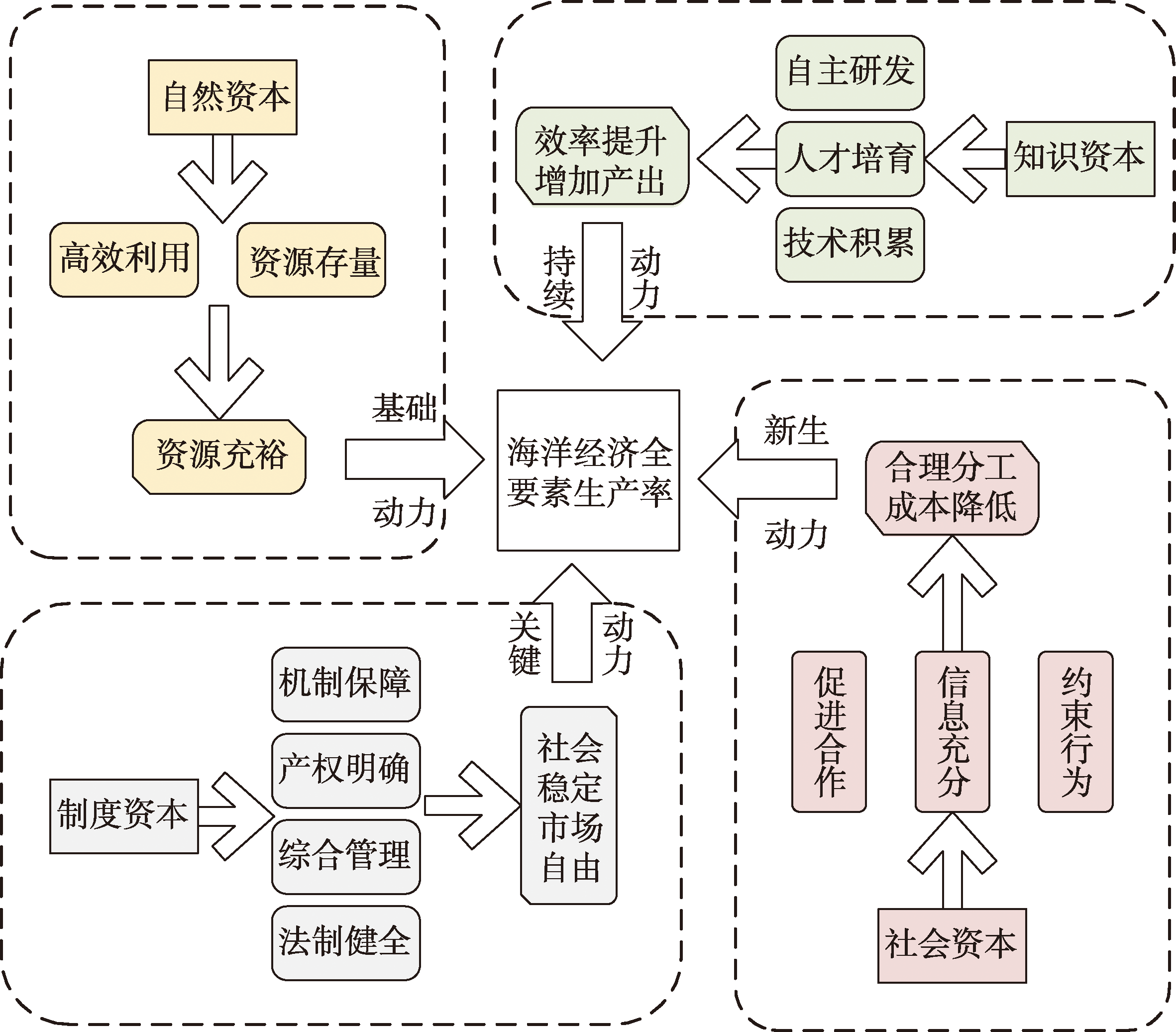
China's marine economy has entered the stage of high-quality development. Total factor productivity of the marine economy, as an important indicator reflecting the structural optimization, technological progress, and management innovation of marine development, is an important characterization of high-quality development level. The improvement of total factor productivity is not only driven by traditional factors such as capital and labor. Although the system theory and an overall perspective should be adopted to constantly explore and discover new drivers of marine economic growth, most of the existing studies are based on a single or a few limited driving factors. Most of them focus on traditional factors such as nature and material, and lack analysis of the common driving mechanism and effects of natural, intellectual, social, and institutional capitals on economic growth. Therefore, in order to explore the dynamic mechanism of total factor productivity of the marine economy, this study used a Translog-stochastic frontier analysis (SFA) model based on a transcendental logarithmic production function to measure the total factor productivity of the marine economy in coastal areas from 2000 to 2020, and identified the dynamic mechanism of development by constructing an evaluation indicator system including natural, intellectual, social, institutional, and external environment factors. The results showed that: 1) The average level of capital factor endowment increased steadily with a significant growth rate, and the accumulation rate of various types of capital generally presented a slow-fast-slow growing trend. The regional factor endowment of various types of capital was quite different. 2) The average total factor productivity of the marine economy was on the rise, which is at the medium level. The growth rate was slow, the regional difference was obvious, and growth showed certain path dependence. 3) The total factor productivity of the marine economy was mainly driven by natural capital in 2000-2012 and by intellectual capital in 2013-2020. The total factor productivity of the marine economy in the northern, central, and southern marine economic zones were mainly driven by natural capital from 2000 to 2012 and by natural, social, and institutional capital respectively from 2013 to 2020. The driving force of natural capital was decreasing, and the driving forces of intellectual, social, and institutional capitals were increasing. The research results can be used as a reference in formulating differentiated marine economic development policies.
Accelerating the green transformation of industrial development and optimizing industrial structure are of great significance for implementing the spirit of the 20th National Congress of the Communist Party of China and the ecological protection and high-quality development strategy in the Yellow River Basin. This study explored the mechanism of environmental regulation enabling the upgrading of industrial structure from the perspective of supply and demand. Using the panel data of 78 prefecture-level cities in the Yellow River Basin from 2008 to 2020, this study empirically tested the mechanism and spatial spillover effect of environmental regulation on the upgrading of industrial structure by the fixed effect model, mediation effect model, and spatial Durbin model. The research showed that: 1) Environmental regulation promotes the upgrading of industrial structure in the Yellow River Basin, and this result is still robust after a series of tests. 2) Environmental regulation promotes the upgrading of industrial structure through factor upgrading and technological innovation on the supply side, and forces the upgrading of industrial structure through consumption upgrading on the demand side. 3) The mechanism of environmental regulation promoting the upgrading of industrial structure is related to regional resource endowment and the degree of Internet development. In non-resource-based cities or cities with a high degree of Internet development, environmental regulation promotes the upgrading of industrial structure by both supply optimization and demand driven, but in resource-based cities or cities with a low degree of Internet development, it only depends on supply optimization. 4) Environmental regulation has a spatial spillover effect on the upgrading of industrial structure, which verifies the "pollution haven" hypothesis. Consequently, in order to further promote the ecological protection and industrial transformation and upgrading in the Yellow River Basin, a number of measures should be taken. For example, the environmental protection system and mechanism should be improved, the supply optimization and demand driven effect of environmental regulation and the advantages of resource endowment should be fully utilized, the deep integration of the Internet and industry should be accelerated, and regional coordination and cooperation should be strengthened.
Understanding the employment preferences of the floating population is crucial for formulating relevant employment policies. In this study, based on the China dynamic monitoring survey data for the floating population in 2017, we categorized the employment options into traditional secondary industry, high-tech manufacturing industry, traditional service industry, and modern service industry, and then scrutinized the floating population's employment choices and spatial variations at the prefecture level. We also established a mixed-effects multinomial logistic regression model to investigate individual and regional factors of the employment choice of the floating population. The main findings of the study are as follows: 1) The majority of the floating population have engaged in employment in the traditional service and traditional secondary industry, with only a small fraction opting for high-tech manufacturing and modern service employment. 2) The percentages of the floating population engaged in employment in the traditional secondary industry and high-tech manufacturing industry were significantly higher in the eastern region than in other regions, particularly in the Yangtze River Delta, Pearl River Delta, and Shandong Peninsula. 3) Most city units in the central-west and Northeast regions had a high concentration of floating population employment in the traditional service industry, with some city units showing relatively high employment percentages in the modern service industry. 4) The floating population's employment choices were influenced by both regional and individual factors. Specifically, regional industrial structure and urban population size affected the regional employment structure, while employment competition and human capital levels of the floating population affected their integration into the regional employment structure. Moreover, gender, age, and population registration status of the floating population also affected their employment choice. The research findings can deepen the understanding of the mechanisms behind the employment choice of the floating population in Chinese cities, especially the relationship between the employment choice of the floating population and urban industrial development, providing references and support for the formulation of employment policies on the floating population.
Trade connectivity is a crucial component in the implementation of the Belt and Road Initiative (BRI). Based on the BRI trade network database, this study integrated three mesoscale analysis methods, including community detection, core-periphery profile, and disparity filter, to build an analytical framework for exploring trade network connectivity and further investigated the spatiotemporal patterns, topological relationship, and structural evolution of "the Belt and Road" trade network from 2000 to 2020 in two dimensions, including nodes and edges. This study aimed to provide scientific references for a comprehensive and in-depth understanding of "the Belt and Road" trade network connectivity. The results show that: 1) The BRI trade network connections and density continuously increased, and the size distribution in trade volumes showed spatial heterogeneity, gradually forming patterns with an apparent hierarchical structure, unbalanced spatial distribution, and increasingly close trade ties. 2) The BRI trade network included five trade blocs with significant geographical proximity, and geographical distance still played an essential role in the evolution of the international trade division of labor system at the global and regional scales. 3) The core-periphery structures of the BRI trade network are undergoing structural adjustments, with the core and peripheral structures showing apparent differentiation and the core-peripheral polarization effect emerging. 4) The backbone structures of the BRI trade network have been continuously expanded and enriched, showing a trend of convergence to the core countries, forming backbone network patterns with China as the absolute core, radiating outward and linking the whole region while India, Russia, and Turkey have also formed their backbone networks in local regions. From the perspective of network science, examining trade network connectivity is crucial for understanding the trade network structure, optimizing the trade development pattern, and enhancing the trade network resilience in "the Belt and Road" regions.
The study of land use morphology and land use transitions is an important approach to analyze regional development. From the perspective of material morphology, efficiency morphology, and correlation morphology, this study examined the recessive land use morphology of rural settlements and constructed a corresponding evaluation indicator system. Combined with the coupling and coordination degree model, this study empirically analyzed the spatiotemporal pattern, process of change, and internal coupling and coordination evolution of recessive land use morphology of rural settlements in Henan Province from 2010 to 2020. The results are as follows: 1) The overall optimization of material morphology in Henan Province was accelerated; The overall deterioration of efficiency morphology was mainly due to the deterioration of the ecological aspect and actual utilization efficiency of rural settlements. The correlation morphology was consistently optimized to a higher level and most advanced around the provincial capital and the northwestern mountainous areas. The former represented the upper limit development of correlation morphology, and the latter reflected the strong improvement of regional weaknesses. 2) By 2020, the comprehensive recessive morphology of rural settlements in the study area had shown a good transition trend after orderly optimization, and the provincial capital area with deep interaction between urban and rural areas played a leading role in the transition. The optimization of the "material-correlation" morphology alleviated the damage caused by the deterioration of the efficiency morphology to the comprehensive recessive morphology. 3) The coupling and coupling and coordination of the three-dimensional recessive morphology were optimized synchronously and continuously in time and space. The coupling and coordination combination state presented a trend of spiral rise from low level differentiation to medium level integration and then to high level differentiation. The coupling and coordinated development of regional three-dimensional recessive land use morphology is not homogeneous, but should form the development poles and dominant axes first, and then drive the regional development by the alternating pattern and process of differentiation-integration. 4) In the future, the study area should pay attention to the deterioration tendency of efficiency morphology, strive for rural endogenous development and ecological construction, promote rural industrial revitalization and population return, optimize the use efficiency, ecological attributes, and spatial structure of rural settlements, and improve the organization of rural-urban spatial system, facility configuration and ecological conservation, and other material aspects, so as to pursue the positive transitions of efficiency morphology and correlation morphology.
Coordination of rural housing and employment is the key to promoting common prosperity and implementing the rural revitalization strategy. Based on the cross-section data of Chongqing Municipality in 2007, 2014, and 2020 and from the perspective of conjugation, this study constructed an evaluation indicator system and evaluation model for the coordinated development of rural housing and employment at the county level, revealed its spatiotemporal differentiation characteristics, and classified the types of housing-employment coordinated development and proposed differentiated rural revitalization paths. The results show that: 1) There were significant spatial and temporal differences in the degree of rural housing-employment coordination in Chongqing Municipality, which generally showed a positive development trend both in terms of quantity and quality and a spatial pattern of high in the central area and low in the surroundings; The balance index of rural housing-employment generally showed an upward trend and a spatial pattern of local prominence and high in the south and low in the north. The efficiency index of rural housing-employment showed a steady upward trend and its spatial distribution pattern changed from clustered to high in the west and low in the east. 2) The coordination of rural housing-employment at the county level can be divided into six types, including high coordination type, medium coordination type, balanced medium type, balanced medium-low efficiency type, strong employment medium-low efficiency type, and strong housing medium-low efficiency type. The high coordination type was mainly distributed in the core area of the main metropolitan area. The medium-low imbalance type was mainly concentrated in the periphery of the main metropolitan area and the northeastern area of the municipality. The severe imbalance type was mainly concentrated in the key districts and counties that received assistance from the rural revitalization program. 3) There was a higher degree of coordination in the economically more developed counties in the main metropolitan area, and these counties can attract their rural population to live and work there. After the implementation of the targeted poverty alleviation program and the rural revitalization strategy, the rural housing-employment coordination in the economically less developed northeast and southeast areas of Chongqing showed a faster improvement trend compared with the main metropolitan area. The backflow of rural population has occurred. Finally, based on the types and spatial distribution characteristics of rural housing-employment coordination, the article put forward a differentiated path for rural revitalization.
The vitality of metro station domains is an important indicator to reflect the vitality of urban space and to test the coordinated and balanced development of station-city space. Taking Xi'an City as an example, this study used multi-source data to construct an indicator system from the two dimensions of crowd activity and built environment to quantitatively evaluate the metro station domain vitality, classify the metro station domains, and analyze their various characteristics based on the comparison of vitality value dimensions. The main conclusions are as follows: 1) The comprehensive vitality of metro station domains was insufficient—with the increase of vitality level, the number of metro stations increased first and then decreased. The number and proportion of stations of the third and fourth vitality levels were higher than those of the first, second, and fifth vitality levels, and the spatial distribution of the vitality of station domains was not balanced. The vitality of metro station domains on both weekdays and weekends went through three stages: rising, stable, and declining. 2) The spatial distribution of metro station vitality in general showed a core-periphery spatial structure. The average vitality of the station domains of the No. 2 metro line running north-south in Xi'an City was the strongest, while the vitality of the station domains of the first and last sections of each line was generally low, and the vitality of the metro transfer station domains, metro stations covering tourist attractions, and university cluster feeder stations were high. Functional mixing degree, subway accessibility, global integration degree, and crowd activity heat played an important role in creating the vitality of metro stations. 3) The metro stations in Xi'an City can be divided into four categories: breeding, growing, balanced, and low degree of maturity. In terms of quantitative distribution, breeding-type station domains > growing-type station domains > low degree of maturity-type station domains > balanced-type station domains, and the spatial distribution also presents an obvious core-periphery characteristic. The core urban areas have a large number of low degree of mature and balanced stations, the main urban areas have balanced, growing, and breeding stations, and the peripheral areas mainly have breeding and growing stations. An improved theoretical framework for spatial vitality evaluation was proposed to strengthen the research on the vitality of Xi'an metro station domains, so as to provide some decision-making reference for the renewal and planning of metro station domains and the empowerment of urban vitality.
Vegetation phenology is a sensitive indicator of climate change, and the effects of different meteorological factors and changes in atmospheric pollutants on peak vegetation growth have not been fully explored. In this study, we used satellite observed normalized difference vegetation index (NDVI) data from 2001 to 2015 to investigate the temporal changes of peak of growing season (POS) and maximum vegetation growth (NDVImax) in the Beijing-Tianjin-Hebei region by the Theil-Sen slope estimator. We also analyzed the effects of preseason temperature and precipitation on POS and NDVImax considering the effects of the fine particulate matter (PM2.5) to investigate the indirect effect of PM2.5 on POS and NDVImax in the region, and the direct effects of PM2.5 on POS and NDVImax by partial correlation analyses. The results showed that earlier POS and higher NDVImax occurred in the Yanshan Mountains and Taihang Mountains, POS in the eastern and southern plains were relatively late, and the NDVImax in Zhangjiakou City, the Yanshan Mountains, and the Taihang Mountains showed a significant increasing trend. Preseason precipitation had a greater impact on POS and NDVImax (the area where significant correlation was found accounted for 12.9% and 15.2% of the study area), which was similar to the effect of temperature (8.7% and 5.9%, respectively). Under the impact of PM2.5, the feedbacks of precipitation and temperature were different in different regions and seasons, and the responses of phenology to the changes of precipitation and temperature caused by PM2.5 also showed spatial heterogeneity. PM2.5 led to the underestimation of the advancing effect of precipitation on POS in the central and eastern plains and northern Yanshan Mountains, overestimation of the advancing effect of precipitation on POS in the northern Zhangjiakou area, and overestimation of the advancing effect of temperature on POS in the eastern and southern plains and the Bashang areas. Overall, the indirect effect of PM2.5 on NDVImax was reducing NDVImax (P<0.1). In the long run, PM2.5 would directly advance POS and increase NDVImax in most areas of the Beijing-Tianjin-Hebei region (P<0.1). Our study revealed the response of peak vegetation growth to climate factors and atmospheric pollutants in the Beijing-Tianjin-Hebei region, which are of great significance for an in-depth understanding of the response and feedback of vegetation growth to changes in the climate and air pollution.
The upper Jinsha River has seen increased variability of stream runoff under the global warming since 1990 and extreme flood events with a 100-year recurrence period have occurred in recent years with flood peaks double or triple that of its normal annual mean flow, which has led to challenges to the utilization of water resources and reservoir operation in the basin. The upper Jinsha River Basin covers a large area but has few observation stations. Compared to the traditional models, the single objective runoff simulation based on machine learning (ML) model has shown advantages in forecasting floods, but the research on runoff prediction of ML model for large rivers originated in alpine mountains is insufficient. In this study, the long short-term memory (LSTM) neural network model was used to simulate the annual runoff process in the upper Jinsha River and the model was driven by daily precipitation, mean temperature, and snow cover area extracted from the 500 m elevation bands of GPM, ERA5-Land, and MODIS snow cover products. The model was built with the runoff observation data as the objective. An ensemble model driven by daily means of all above parameters of the whole basin was also built and compared with the LSTM model. Both models used data from 2001-2014 for training and 2015-2019 for validation. The results show that the Nash-Sutcliffe efficiency (NSE) of the two models was greater than or equal to 0.80 within 15 days lead-time, the models had similar NSE in adjacent lead-times, and the NSE decreased to about 0.70 for the lead-times of 25 and 30 days, which indicates that the runoff simulation results of the two models are reasonable at the 30 days and shorter lead-times. Better results of runoff simulation were generated by the LSTM model driven by the vertical zonation data for the 1-5 days lead-times as compared to the ensemble model. The advantage of the vertical zonation data-driven model reduced for the 7-13 days lead-time and the simulation results are equivalent for the 15-30 days lead-time. The vertical zonation data-driven model was superior to the ensemble model in simulating flood season runoff. In general, the runoff simulation accuracy of the vertical zonation data-driven model is the highest at the 3 days lead-time, especially for spring and summer floods. We conclude that the developed model driven by the elevation zonation data can provide reliable prediction of floods, which can provide a reference for the operation of the downstream cascade hydropower stations of the middle Jinsha River. However, the improvement of the ML model for extreme spring floods should still be an important direction in future research.
In the context of global climate change, compound flood disasters occur frequently in coastal areas, and thus it is of great significance to examine the related disaster risks. In this study, 223 typhoon events that affected Hong Kong from 1962 to 2021 were selected as statistical samples to analyze the compound disaster risk of rainfall and storm surges in Hong Kong under the influence of typhoons. The Mann-Kendall method was used to analyze the characteristics of typhoon events, and we found that the typhoons in Hong Kong during the past 60 years show the characteristics of low probability and high impact. The optimal marginal distribution function of the maximum storm water increase and cumulative rainfall under typhoon events was determined by a variety of statistical testing methods, and the Frank Copula function was used to fit the joint probability distribution of rainfall-storm surge compound disasters. Based on the risk assessment and design value calculation of single factors and compound disasters, the risk rate of the "or" return period is high, and the risk rate of the "and" return period is low. Finally, we concluded that the optimal design values of maximum storm surge and cumulative rainfall in the secondary return period should be selected for the design of coastal engineering projects in the Guangdong-Hong Kong-Macao Greater Bay area. This study showed the compound disaster risk characteristics of the Greater Bay area and provides a reference for the construction of relevant disaster scenarios.
Due to the changing environment such as damming and storm surges, delta regions are extremely prone to compound flooding. Analyzing the occurrence probability of compound floods caused by storm surges and runoff, and clarifying the dominant factors of compound floods are of great significance for improving flood protection standards and preventing compound flood disasters. With the help of the Spearman correlation coefficient, Mann-Kendall trend test, and Copula function, the runoff and storm surge data of the river network in the Pearl River Delta (PRD) from 1961 to 2017 were selected to explore the correlation of factors and quantify the return period of compound floods. The results show that the compound floods at the North River stations were dominated by the extreme value of runoff, but showed a significant trend towards dominated by the extreme value of storm surges; while the compound floods at the West River stations were dominated by the extreme value of storm surges. Compound floods at the Huangjing and Xipaotai stations showed a significant trend towards dominated by the extreme value of runoff, and the transformation trends of other stations were the same as that of the North River stations. The degree of difference of the correlation coefficients of stations in the flood and dry seasons varied, and the sequence dominated by runoff extreme values showed a larger difference, especially in the flood season, with the maximum difference of 0.35. The combined return period of compound floods was about 50% shorter than that of the univariate ones. In the case of the univariate once-in-a-decade situation, the stations with the highest probability of occurrence of the bivariate flood are: Wanqingshaxi Station dominated by runoff extremes (5.71 years) and Hengmen Station (5.54 years) dominated by storm surge extremes, and significantly correlated stations in the runoff extremes dominant sequence are more sensitive to storm surge changes. The research results can provide protection schemes focusing on different dominant disaster-causing factors (such as storm surge, runoff, and so on) for flood control and disaster risk reduction of the PRD river network.
Since the 1970s, the value of "emotion" in geographic research has been highlighted, resulting in a humanistic geography that focuses on human experiences and emotions about places. The process of shaping "place" is also the process of individual growth and human cultural evolution. It is important to explore how humanistic geographers like Yi-fu Tuan write about place at the methodological level. From the perspective of Yi-fu Tuan's "self", this paper rediscovers and recreates his place experiences, focusing on the relationship between place experiences and individual thought formation, life practices and emotional changes, and analyzing his writing arts in order to grasp the core concepts and methodological elements of humanistic geography. Yi-fu Tuan's distinctive writing art is formed mainly through "five combinations": the combination of geography and philosophy, the combination of dialectic of dualistic values, the combination of experience and experiment, the combination of linguistic expression and cultural comparison, and the combination of paraphrase and self-narrative. Yi-fu Tuan's humanistic geography reveals the complexity and vividness of the interaction between "emotion" and "landscape", and the essence of place and self in a constantly intertwined and co-generative process.
Infrastructure investment and construction is an important factor for understanding socioeconomic development. As the large-scale cross-border infrastructure investment and construction continue to thrive in recent years, however, it is not unusual to find those failed to achieve sustainable development. Such infrastructure-led development model is increasingly questioned. This article reviewed different conceptualizations and characteristics of infrastructure and infrastructure-led development model, and examined relevant Chinese and international research focusing on the theoretical assumptions, bases, and explanation of mechanism through time: 1) During the Keynesian period, infrastructure as public goods matched national policies and provided key support for industrial and social development. 2) In the neoliberal era, infrastructure, on the one hand as an "input factor of production", influenced socioeconomic development by external effects; and on the other hand, as a "component" embedded in the socioeconomic system, adapted to and adjusted the socioeconomic environment. 3) In the post-neoliberal period, the mutual influence between complicated infrastructure and the socioeconomic environment reveals that their relationships are a dynamic process rather than simply promoting or suppressing. Therefore, combined with the theory of co-evolution, this article proposed a research framework of "infrastructure-institutions and culture-industry and trade foundations" co-evolution for sustainable development-oriented infrastructure investment and construction practices.
Driven by various natural and human factors, the land system in China is undergoing profound changes. Modeling land system changes can provide not only decision support for major national needs such as territorial spatial planning but also research support for mechanisms of land use changes and modeling of the integrated terrestrial system. This study reviewed studies of land use change modeling through analyzing the origin and development of land use change models. We summarized the development trends since the 1990s and discussed existing challenges and future prospects. The review showed that there exist two development trends in land use change models: the balance between demand and supply, and the combination and optimization of model parameters. The former trend is reflected in an ideological transformation from consideration of only supply or demand to consideration of supply-demand balance when modeling land use changes. Also, there exist two routes to realizing this ideological transformation, namely the top-down route of downscaling spatialization and the bottom-up route of coupling scientific demands and models. The latter trend is not only reflected in the changes of modeling rules from descriptive rules to combined parameterized rules but also in a series of efforts aiming at the optimization of model parameters, specifically in the improvement of regression models and the combination of machine learning methods. Existing challenges of land use change models lie in the divergence of core mathematical mechanisms, challenges of the fledging transformation from unsupervised to supervised simulation, and the deficiency of the new paradigms (vector data-based and integrated data-based) to overcome the shortcomings of the old paradigm (raster data-based). This study recommends more attention to the mathematical mechanisms of land use change models, through evaluations of existing mechanisms, and the incorporation of complexity in analytic expressions. Future land use change models could be improved through coupling series of planning policies under the new paradigms to promote the further development of supervised simulation.
The Coupled Model Intercomparison Project (CMIP) has developed rapidly from establishing in the mid-1990s, which provides irreplaceable data support for global climate change simulation and future climate change projection. This paper reviewed systematically the development process from CMIP1 to CMIP6, including theoretical framework, future scenario construction, international participation, etc. On this basis, the paper comprehensively summarized the performance of CMIP models in simulating global and China's temperature, precipitation, and other variables. Furthermore, the simulation results of historical experiment in CMIP3, CMIP5 and CMIP6 was emphatically compared. With the development of CMIP, the simulation performance of global climate models has also been improved due to the improvements of physical parameterization scheme and spatial resolution. However, the performances of CMIP models in simulating climate characteristics at regional scale are still limited, especially for the simulations of precipitation change in small-middle scale, and the simulation performances of different models varies greatly. Finally, the paper looks forward to the possible development directions of CMIP models according to the above problems.
China's rapid urbanization is characterized by rural-to-urban migration that was mainly driven by economic opportunities in the past several decades. With the increase of income, however, the factors that influence migration are expected to change from what they were in the past. In recent years, increasingly more migrants chose to change where they live for the pursuit of amenity, which is termed amenity migration, amenity-led migration, or amenity-driven migration. Against this background, it is necessary to follow the concept and theories of amenity migration in international literature for understanding China's migration transition and its interaction with urban-rural development transformation. This article provided a comprehensive review of the progress of international research on amenity migration. It is found that the concept of amenity emphasizes a place-specific or location-specific feature. Different places have their own unique amenity, with significant differences between urban and rural areas. Amenity can be divided into natural amenity, service amenity, and social amenity. Natural amenity refers to the natural environment that makes people comfortable. Service amenity depends on various human-made facilities. Social amenity dictates a pleasant social and cultural atmosphere. Numerous empirical studies have explored the impact of amenity on migration based on the equilibrium model and found different effects of different categories of amenity, but the research on the mechanism of influence and heterogeneity is still weak. Amenity migration is defined as a kind of migration behavior mainly driven by amenity factors, which profoundly affects the urban-rural development transformation. Amenity migration of talents generates positive urban innovation and growth effects, and amenity migration of the urban middle class causes rural gentrification. Finally, this article discussed directions of the theoretical and empirical research of amenity migration and its inspiration for China's urban-rural development transformation. This article contributes to extending the international view of research on China's internal migration and to better targeting and interpreting the future changes and mechanisms of migration patterns.