
Spatial differentiation and interaction of rural settlements’ morphology and functions in counties: The case of Shanxian County, Southwest Shandong
Received date: 2023-12-26
Revised date: 2024-05-27
Online published: 2024-09-25
Supported by
National Natural Science Foundation of China(52378065)
Tianjin Philosophy and Social Science Planning Think Tank Project(TJZDDY23-23)
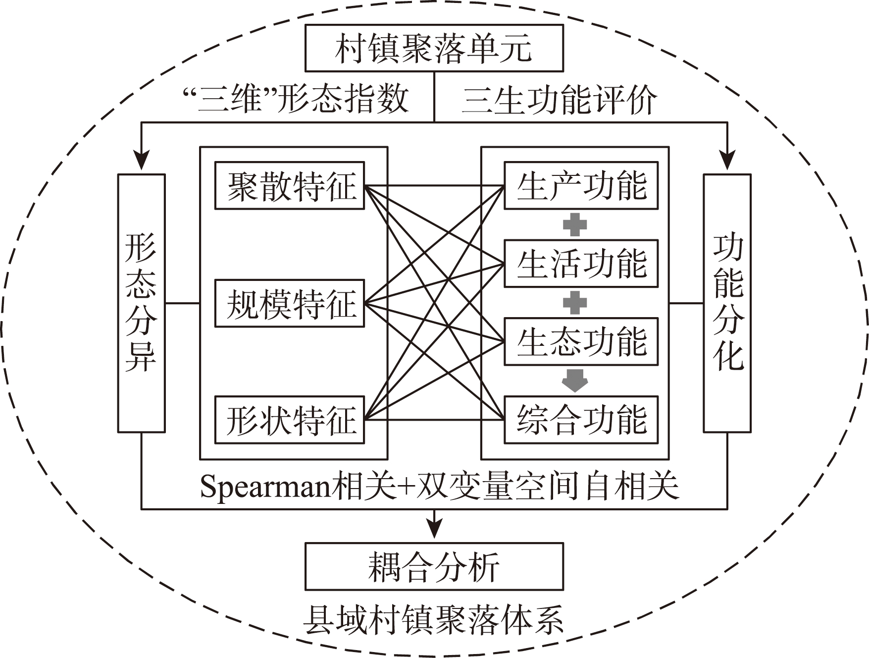
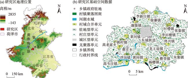
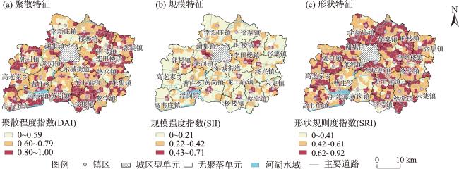
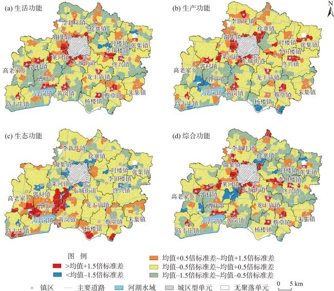
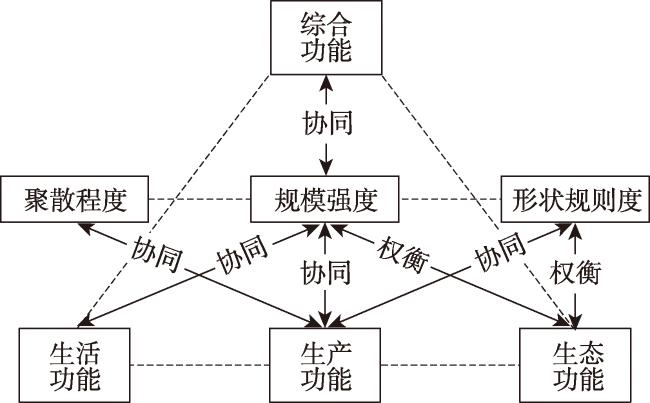
Finding new theoretical perspectives to effectively identify and analyze the spatial differentiation characteristics and patterns of rural settlements can provide basic support for planning the spatial reconstruction of rural settlements and the path of revitalization and development of rural areas. Taking 442 rural settlement units in Shanxian County, Southwest Shandong as the research object, this study constructed an analytical framework of morphological differentiation-functional differentiation-interactive relationship. By developing a quantitative evaluation method of spatial morphology and functions adapted to the third national land survey data, the spatial differentiation characteristics of rural settlements in the county were systematically identified. Then, the interaction between spatial morphology and functions of rural settlements was analyzed through Spearman's rho and bivariate spatial autocorrelation methods. The results show that: 1) The rural settlements in Shanxian County are characterized by the spatial pattern of "dispersion and homogeneity", which is a typical feature of traditional plain agricultural areas. In terms of distribution, the rural settlements show the layout characteristics of "scattered villages are widely distributed, interspersed with agglomerated villages"; In terms of scale, the rural settlements show two spatial structure modes: the circular zonal type with the towns as the center and the point-axis type along the main traffic lines; In terms of shape, most rural settlements have regular boundaries, and irregular settlements are oriented by roads and micro topography. 2) The level of living function of rural settlement units in Shanxian County shows circular zonal distribution around the city and towns; The level of production function shows a point-axis distribution characteristic along the main traffic lines; The settlement units with better ecological function have higher proximity to surface water bodies; The distribution of settlement units with better comprehensive functions has obvious spatial preference toward centers and roads, and has negative correlation with ecological functions. 3) The three-dimensional morphology and functions are mainly collaborative, and the trade-off relationship is mainly between the three-dimensional morphology and ecological function. The coordination/trade-off between scale and multiple functions is the most prominent. The morphology-function coordination/trade-off has a function-oriented spatial differentiation rule. The spatial reconstruction and governance of rural settlements in traditional plain agricultural areas need to take function improvement as the core goal, and strengthen the collaborative optimization of morphology and functions.
WANG Lin , TIAN Jian , XU Xiaonan , ZENG Jian , XIN Ruhong . Spatial differentiation and interaction of rural settlements’ morphology and functions in counties: The case of Shanxian County, Southwest Shandong[J]. PROGRESS IN GEOGRAPHY, 2024 , 43(9) : 1730 -1743 . DOI: 10.18306/dlkxjz.2024.09.004
表1 景观指数因子载荷矩阵及“三维”形态表征指数Tab.1 Landscape index factor loading matrix and three-dimensional morphology index |
| 景观指数 | 英文缩写 | 主成分 | 村镇聚落“三维”形态 表征指数及其内涵 | ||
|---|---|---|---|---|---|
| 1 | 2 | 3 | |||
| 斑块密度(个/km²) | PD | -0.908 | -0.106 | -0.202 | 聚散程度指数(DAI):村镇聚落分布密度、聚散程度 |
| 斑块结合度指数 | COHESION | 0.873 | 0.293 | 0.017 | |
| 斑块数量(个) | NP | -0.845 | 0.074 | -0.208 | |
| 聚集度指数(%) | AI | 0.703 | 0.329 | -0.56 | |
| 破碎度指数 | SPLIT | -0.512 | -0.312 | -0.021 | |
| 斑块占景观面积比例(%) | PLAND | 0.096 | 0.886 | 0.071 | 规模强度指数(SII):村镇聚落用地规模大小、开发强度 |
| 斑块总面积(hm²) | CA | -0.13 | 0.876 | -0.018 | |
| 最大斑块指数(%) | LPI | 0.455 | 0.791 | 0.126 | |
| 平均斑块面积(hm²) | MPS | 0.431 | 0.747 | 0.222 | |
| 平均斑块分维数 | FRAC_MN | 0.104 | 0.079 | 0.961 | 形状规则度指数(SRI):村镇聚落平面形状规则度 |
| 平均斑块形状指数 | MSI | 0.235 | 0.233 | 0.924 | |
| 平均最邻近距离(m) | ENN | 0.03 | -0.115 | -0.401 | |
表2 基于用地类型的三生功能评分体系Tab.2 Living-production-ecological function assessment system of rural settlement unit based on land use classification |
| 一级地类 | 二级地类 | 功能类型 | 一级地类 | 二级地类 | 功能类型 | ||||||||||||
|---|---|---|---|---|---|---|---|---|---|---|---|---|---|---|---|---|---|
| 编码 | 名称 | 编码 | 名称 | 生产功能 | 生活功能 | 生态功能 | 编码 | 名称 | 编码 | 名称 | 生产功能 | 生活功能 | 生态功能 | ||||
| 0 | 湿地 | 1106 | 内陆滩涂 | 0 | 0 | 5 | 8 | 公共管理与 | 08H2 | 科教文卫用地 | 0 | 5 | 0 | ||||
| 1 | 耕地 | 01A | 果蔬大棚用地 | 5 | 0 | 0 | 公共服务用地 | 809 | 公用设施用地 | 3 | 5 | 0 | |||||
| 01B | 一般耕地 | 3 | 0 | 1 | 810 | 公园与绿地 | 1 | 5 | 5 | ||||||||
| 2 | 园地 | 201 | 果园 | 3 | 0 | 3 | 0810A | 广场用地 | 1 | 5 | 1 | ||||||
| 204 | 其他园地 | 3 | 0 | 3 | 9 | 特殊用地 | 9 | 特殊用地 | 1 | 1 | 1 | ||||||
| 3 | 林地 | 301 | 乔木林地 | 1 | 0 | 5 | 10 | 交通运输 | 1003 | 公路用地 | 3 | 5 | -3 | ||||
| 302 | 竹林地 | 3 | 0 | 5 | 用地 | 1004 | 城镇村道路用地 | 3 | 5 | -3 | |||||||
| 307 | 其他林地 | 1 | 0 | 5 | 1005 | 交通服务场站用地 | 3 | 5 | -3 | ||||||||
| 4 | 草地 | 404 | 其他草地 | 0 | 0 | 3 | 1006 | 农村道路 | 1 | 1 | -1 | ||||||
| 5 | 商业服务业 | 05H1 | 商业服务业 | 5 | 5 | -1 | 11 | 水域及水利设施用地 | 1101 | 河流水面 | 1 | 1 | 5 | ||||
| 用地 | 设施用地 | 1102 | 湖泊水面 | 1 | 1 | 5 | |||||||||||
| 508 | 物流仓储用地 | 5 | 1 | -3 | 1103 | 水库水面 | 1 | 0 | 3 | ||||||||
| 6 | 工矿用地 | 601 | 工业用地 | 5 | 0 | -5 | 1104 | 坑塘水面 | 1 | 0 | 3 | ||||||
| 602 | 采矿用地 | 5 | 0 | -5 | 1104A | 养殖坑塘 | 3 | 0 | 1 | ||||||||
| 7 | 住宅用地 | 701 | 城镇住宅用地 | 1 | 5 | 0 | 1107 | 沟渠 | 1 | 0 | 1 | ||||||
| 0702A | 新型农村社区 | 1 | 5 | 0 | 其他土地 | 1109 | 水工建筑用地 | 1 | 0 | -1 | |||||||
| 702 | 农村宅基地 | 1 | 3 | 0 | 12 | 1201 | 空闲地 | 0 | 0 | 1 | |||||||
| 8 | 公共管理与 | 08H1 | 机关团体新闻 | 0 | 5 | 0 | 1202 | 设施农用地 | 3 | 1 | 1 | ||||||
| 公共服务用地 | 出版用地 | 1206 | 裸土地 | 0 | 0 | 1 | |||||||||||
表3 村镇聚落空间形态与功能指数数理统计Tab.3 Statistics of morphology and function index of rural settlements |
| 表征指数 | 取值范围 | 均值 | 变异系数 | 莫兰指数 | |||
|---|---|---|---|---|---|---|---|
| Moran's I | P值 | Z值 | |||||
| 形态特征 | 聚散程度(DAI) | (0, 1.00] | 0.74 | 0.21 | 0.107 | 0.003 | 3.61 |
| 规模强度(SII) | (0, 0.71] | 0.20 | 0.49 | 0.050 | 0.038 | 1.86 | |
| 形状规则度(SRI) | (0, 0.92] | 0.57 | 0.26 | 0.141 | 0.001 | 4.77 | |
| 功能特征 | 生活功能(LFS) | [0.16, 3.03] | 0.79 | 0.34 | 0.387 | 0.001 | 13.58 |
| 生产功能(PFS) | [1.38, 4.54] | 2.82 | 0.29 | 0.401 | 0.001 | 14.12 | |
| 生态功能(EFS) | [0.09, 3.95] | 2.46 | 0.17 | 0.412 | 0.001 | 14.61 | |
| 综合功能(CFS) | [1.34, 3.45] | 2.05 | 0.23 | 0.313 | 0.001 | 11.21 | |
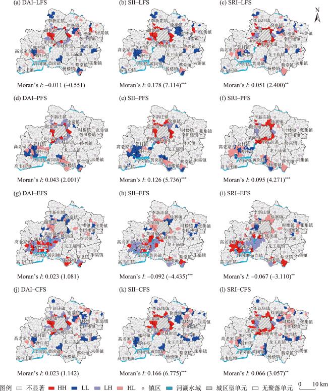
表4 村镇聚落空间形态—功能Spearman相关分析Tab.4 Spearman's rho between multiple spatial morphology and functions of rural settlements |
| 指数 | 生活 功能 | 生产 功能 | 生态 功能 | 综合 功能 | |
|---|---|---|---|---|---|
| 规模 强度 | 相关系数(ρ) | 0.570*** | 0.380*** | -0.239*** | 0.549*** |
| 显著性(α) | <0.001 | <0.001 | <0.001 | <0.001 | |
| 聚散 程度 | 相关系数(ρ) | -0.019 | 0.093* | -0.029 | 0.033 |
| 显著性(α) | 0.696 | 0.048 | 0.541 | 0.484 | |
| 形状 规则度 | 相关系数(ρ) | -0.051 | 0.160** | -0.101* | -0.022 |
| 显著性(α) | 0.282 | 0.002 | 0.034 | 0.643 | |
注:***、**、*分别表示在0.001、0.01、0.05水平上显著(双尾)。 |
| [1] |
金其铭. 农村聚落地理[M]. 北京: 科学出版社, 1988: 20.
[
|
| [2] |
李小建, 胡雪瑶, 史焱文, 等. 乡村振兴下的聚落研究: 来自经济地理学视角[J]. 地理科学进展, 2021, 40(1): 3-14.
[
|
| [3] |
李旭, 崔皓, 李和平, 等. 近40年我国村镇聚落发展规律研究综述与展望: 基于城乡规划学与地理学比较的视角[J]. 城市规划学刊, 2020(6): 79-86.
[
|
| [4] |
刘志林, 丁银平, 角媛梅, 等. 中国西南少数民族聚居区聚落分布的空间格局特征与主控因子分析: 以哈尼梯田区为例[J]. 地理科学进展, 2021, 40(2): 257-271.
[
|
| [5] |
|
| [6] |
董光龙, 许尔琪, 张红旗. 黄淮海平原不同类型农村居民点空间分布及变化特征研究[J]. 资源科学, 2017, 39(7): 1248-1258.
[
|
| [7] |
王林, 曾坚. 鲁西南地区村镇聚落空间分异特征及类型划分: 以菏泽市为例[J]. 地理研究, 2021, 40(8): 2235-2251.
[
|
| [8] |
冯德东, 冯应斌, 赵玲珑, 等. 特色保护类村域农村居民点空间重构探析[J]. 地理科学进展, 2022, 41(5): 825-837.
[
|
| [9] |
|
| [10] |
|
| [11] |
李智, 刘劲松. 冀南平原典型农业村落转型特征及成长机制[J]. 地理学报, 2021, 76(4): 939-954.
[
|
| [12] |
|
| [13] |
刘彦随, 刘玉, 翟荣新. 中国农村空心化的地理学研究与整治实践[J]. 地理学报, 2009, 64(10): 1193-1202.
[
|
| [14] |
|
| [15] |
|
| [16] |
王勇, 李广斌. 苏南乡村聚落功能三次转型及其空间形态重构: 以苏州为例[J]. 城市规划, 2011, 35(7): 54-60.
[
|
| [17] |
曲衍波, 魏淑文, 商冉, 等. 基于“点—面”特征的农村居民点空间形态识别[J]. 资源科学, 2019, 41(6): 1035-1047.
[
|
| [18] |
邬建国. 景观生态学:格局、过程、尺度与等级[M]. 2版. 北京: 高等教育出版社, 2007: 106-120.
[
|
| [19] |
|
| [20] |
|
| [21] |
刘继来, 刘彦随, 李裕瑞. 中国“三生空间”分类评价与时空格局分析[J]. 地理学报, 2017, 72(7): 1290-1304.
[
|
| [22] |
曲衍波, 王世磊, 赵丽鋆, 等. 山东省乡村地域多功能空间格局与分区调控[J]. 农业工程学报, 2020, 36(13): 222-232.
[
|
| [23] |
刘彦随, 刘玉, 陈玉福. 中国地域多功能性评价及其决策机制[J]. 地理学报, 2011, 66(10): 1379-1389.
[
|
| [24] |
|
| [25] |
|
| [26] |
任国平, 刘黎明, 李洪庆, 等. 都市郊区乡村景观多功能权衡—协同关系演变[J]. 农业工程学报, 2019, 35(23): 273-285.
[
|
| [27] |
朱庆莹, 胡伟艳, 赵志尚. 耕地多功能权衡与协同时空格局的动态分析: 以湖北省为例[J]. 经济地理, 2018, 38(7): 143-153.
[
|
| [28] |
刘玉, 郜允兵, 潘瑜春, 等. 基于多源数据的乡村功能空间特征及其权衡协同关系度量[J]. 地理研究, 2021, 40(7): 2036-2050.
[
|
| [29] |
|
| [30] |
李欣, 方斌, 殷如梦, 等. 江苏省县域“三生”功能时空变化及协同/权衡关系[J]. 自然资源学报, 2019, 34(11): 2363-2377.
[
|
| [31] |
鲁西奇. 散村与集村: 传统中国的乡村聚落形态及其演变[J]. 华中师范大学学报(人文社会科学版), 2013, 52(4): 113-130.
[
|
/
| 〈 |
|
〉 |