
Cognition of contemporary city maps and interpretation of their map representation: Case study of a German-made urban planning map of Qingdao in 1910
Received date: 2023-07-31
Revised date: 2023-12-23
Online published: 2024-06-21
Supported by
National Natural Science Foundation of China(51808305)
Humanities and Social Science Fund of the Ministry of Education(23YJCZH254)
Natural Science Foundation of Shandong Province(ZR2023ME114)
Natural Science Foundation of Shandong Province(ZR2022ME149)
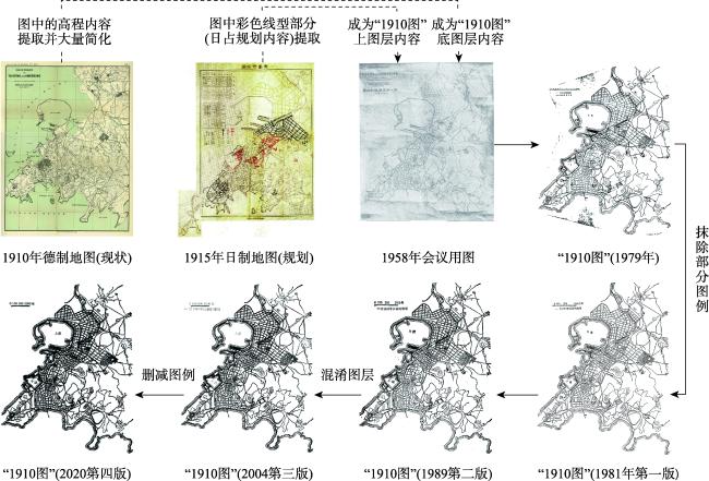
Since the advent of scholarship initiated by John Brian Haley on the nexus between map and "knowledge-power", research in this domain has proliferated significantly. Nevertheless, extant studies predominantly emphasize the perspective of the original map creators, neglecting an examination of the map dissemination process from the perspective of the general map user. Utilizing the city planning map of Qingdao, purportedly crafted by German in 1910, as a case study, this study employed georeferencing techniques and a comparative analysis of map contents to elucidate the underlying urban planning truth and the historical intricacies hidden behind the map's representation. The results indicate that in the 1950s, some specific map users, who were also specialized urban and rural planning scholars, replicated and reconfigured a contemporary city map produced by German in 1910 and an urban planning map created by Japanese in 1915, resulting in the generation of an entirely new map. Consequently, this distorted map representation has engendered a totally new "historical reality" that subverts people's cognition and challenges the initial map interpretation, facilitated by the extensive propagation of authoritative textbooks. The interplay between the inherent values and ideologies of a specific social class as map users and the map representation in their participation process was further discussed. In essence, this study augmented and nuanced Haley's discourse on map power from the perspective of map users, while also contributing a novel dimension to the cartographic historical analysis, specifically focusing on urban planning maps.
XU Min , WU Tingjin , ZHAO Lin . Cognition of contemporary city maps and interpretation of their map representation: Case study of a German-made urban planning map of Qingdao in 1910[J]. PROGRESS IN GEOGRAPHY, 2024 , 43(6) : 1219 -1232 . DOI: 10.18306/dlkxjz.2024.06.013
图2 1897—1915年间成图的大比例青岛地图概况注:据本文所收集地图资料自绘。图中所展示地图的资料来源均为《胶澳发展备忘录》③(《胶澳发展备忘录》原是德国胶澳总督府编写的年度工作报告,自1898 年10 月起每年出版一册,直至1909 年10 月,由柏林帝国印刷所印刷,后改名《胶澳年鉴》。这些工作报告比较全面、系统地记录了德国殖民者统治和经营胶澳租借地的各项政策措施及其实施情况,也从一个侧面展现青岛近代早期的历史发展进程。《胶澳发展备忘录》中还附有大量规划图、地图、照片等,这在其他档案资料中也比较少见,对研究青岛城市早期的规划与建设有较高的史料价值。),自左至右依次为《胶澳发展备忘录 截止到1898年10月底》附录2、《胶澳发展备忘录 1898年10月至1899年10月》附录6、《胶澳发展备忘录 1899年10月至1900年10月》附录3、《胶澳发展备忘录 1900年10月至1901年10月》附录4、《胶澳发展备忘录 1902年10月至1903年10月》附录13及《胶澳发展备忘录 1905年10月至1906年10月》附录10。 Fig.2 Temporal distribution of large scale maps of Qingdao made between 1897 and 1914 |
图3 1910年德制现状地图(a)、“1910图”(b)与1915年日制规划地图(c)对比注:a、b、c图纸资料来源分别为德国亚琛图书馆(电子扫描件)、参考文献[15]和日本国立公文书馆。图c中红色、黑色、黄色为加绘的规划内容,在1915年日占规划中的三期工事中,红色路网为第一期工事,黑色为第二期,黄色为第三期。 Fig.3 Comparison between the map of current Qingdao made by German in 1910 (a), the "1910 Map" (b), and the urban planning map of Qingdao made by Japanese in 1915 (c) |
图4 1910年德制现状地图(a1, a2)、“1910图”(b1, b2)及1915年青岛市街图(c1, c2)的局部细节对比注:据图3中各幅图纸放大后作为底图,每幅图取两个局部,自绘而成;图中红色线条为图中完全相同之处,红色色块为不同之处。 Fig.4 Comparison of map details between the map of current Qingdao made by German in 1910 (a1, a2), the "1910 Map" (b1, b2), and the urban planning map of Qingdao made by Japanese in 1915 (c1, c2) |
图6 1905—1915年间青岛城市地图中的港区与“1910图”对比注:以各底图为基础自绘。a、b、c、d、e、f、g、h底图资料来源分别为青岛市档案馆、《胶澳发展备忘录 1905年10月至1906年10月》附录10、www.oldmapsonline.org、德国亚琛图书馆(电子扫描件)、www.oldmapsonline.org、日本国立公文书馆、青岛市档案馆、日本国立公文书馆、参考文献[15]。 Fig.6 Comparison of the harbor between the maps of 1905-1915 and the "1910 Map" |
北京建筑大学陈雳老师提供的德国亚琛图书馆1910年“青岛及周边地区概览图”,为解开“1910图”之谜提供了关键线索。几位审稿专家帮助本文修订了相关理论、概念和书写规范等问题,并提供了非常细致的修改建议。在此一并致以诚挚谢意!
| [1] |
|
| [2] |
|
| [3] |
|
| [4] |
|
| [5] |
|
| [6] |
马克·蒙莫尼尔. 会说谎的地图[M]. 黄义军, 译. 北京: 商务印书馆, 2012.
[
|
| [7] |
孙俊. 知识地理学: 空间与地方间的叙事转型与重构[M]. 北京: 科学出版社, 2016: 161-187.
[
|
| [8] |
王韬, 刘云刚. 地图与制图术: 国际批判制图学/GIS研究进展[J]. 地理科学进展, 2022, 41(6): 1097-1108.
[
|
| [9] |
安传艳, 李同昇. 地图表征的权力运作机制: 建构的知识话语[J]. 地理研究, 2019, 38(8): 2099-2112.
[
|
| [10] |
唐晓峰. 地图中的权力、意志与秩序[J]. 中国学术, 2000, 2(4): 261-268.
[
|
| [11] |
潘晟. 谁的叙述: 明代方志地图绘制人员身份初考[J]. 中国历史地理论丛, 2004(1): 75-82, 159.
[
|
| [12] |
潘晟. 地图的作者及其阅读: 以宋明为核心的知识史考察[M]. 南京: 江苏人民出版社, 2013.
[
|
| [13] |
何光强, 宋秀琚. 地图投影与全球地缘政治分析: 一种空间认知的视角[J]. 人文地理, 2014, 29(2): 113-122.
[
|
| [14] |
叶凯蒂. 从十九世纪上海地图看对城市未来定义的争夺战[J]. 中国学术, 2000, 2(3): 88-121.
[The battle for the definition of the futureof the city from the maps of Shanghai in the 19th Century[J]. Academia of China, 2000, 2(3): 88-121. ]
|
| [15] |
董鉴泓. 中国城市建设史[M]. 北京: 中国建筑工业出版社, 1981: 142.
[
|
| [16] |
董鉴泓. 中国近代一些城市规划图的评析[J]. 同济大学学报, 1979, 7(4): 32-47.
[
|
| [17] |
董鉴泓. 中国城市建设史[M]. 第二版. 北京: 中国建筑工业出版社, 1989: 271.
[
|
| [18] |
董鉴泓. 中国城市建设史[M]. 第三版. 北京: 中国建筑工业出版社, 2004: 286.
[
|
| [19] |
董鉴泓. 中国城市建设史[M]. 第四版. 北京: 中国建筑工业出版社, 2020, 240.
[
|
| [20] |
汪坦, 藤森照信. 中国近代建筑总揽: 青岛篇[M]. 北京: 中国建筑工业出版社, 1992.
[
|
| [21] |
杨秉德. 中国近代城市与建筑(1840—1949) [M]. 北京: 中国建筑工业出版社, 1993.
[
|
| [22] |
宋连威. 青岛城市的形成[M]. 青岛: 青岛出版社, 1998.
[
|
| [23] |
曹洪涛, 刘金声. 中国近现代城市的发展[M]. 北京: 中国城市出版社, 1998.
[
|
| [24] |
青岛市史志办公室. 青岛市志: 城市规划建筑志[M]. 北京: 新华出版社, 1999.
[ Qingdao Municipal History Office. Qingdao municipal chronicle:Urban planning and architecture. Beijing, China: Xinhua Publishing House, 1999. ]
|
| [25] |
陆安. 青岛近现代史[M]. 青岛: 青岛出版社, 2001.
[
|
| [26] |
庄林德, 张京祥. 中国城市发展与建设史[M]. 南京: 东南大学出版社, 2002.
[
|
| [27] |
青岛市档案馆. 青岛地图通鉴[M]. 济南: 山东省地图出版社, 2002.
[ Qingdao Municipal Archives. Qingdao map guide, Jinan, China: Shandong Map Publishing House, 2002. ]
|
| [28] |
刘敏. 青岛旧城保护更新研究[M]. 青岛: 中国海洋大学出版社, 2009.
[
|
| [29] |
张潇. 中国青岛市历史街区再生研究[M]. 徐州: 中国矿业大学出版社, 2016.
[
|
| [30] |
|
| [31] |
托尔斯藤·华纳. 近代青岛的城市规划与建设[M]. 青岛市档案馆, 译. 南京: 东南大学出版社, 2011: 255-257.
[
|
| [32] |
李东泉. 青岛城市规划与城市发展研究[M]. 北京: 中国建筑工业出版社, 2012: 132-133.
[
|
| [33] |
|
| [34] |
青岛守备军民政部土木部. 土木志[M]. 青岛: 青岛守备军民政部, 1920: 4.
[ Ministry of civil Affairs of Qingdao Garrison. Civil engineering record[M]. Qingdao, China: Ministry of civil Affairs of Qingdao Garrison, 1920: 4. ]
|
| [35] |
金山. 青岛近代城市建筑: 1922—1937[M]. 上海: 同济大学出版社, 2016: 16-19.
[
|
| [36] |
青岛市档案馆. 图说老青岛: 日本第一次统治时期[M]. 青岛: 青岛出版社, 2021: 1-4.
[ Archives of Qingdao City. Qingdao in old pictures and photos: During the period of Japan's first reign, Qingdao, China: Qingdao Publishing House, 2021: 1-4. ]
|
| [37] |
青岛市档案馆. 青岛开埠十七年: 《胶澳发展备忘录》全译[M]. 北京: 中国档案出版社, 2007: 552, 715.
[ Archives of Qingdao City. Seventeen years since Qingdao opened its port:Full translation of the memorandum on the development of Jiao'ao. Beijing, China: China Archives Publishing House, 2007: 552, 715. ]
|
| [38] |
寿杨宾. 青岛海港史(近代部分)[M]. 北京: 人民交通出版社, 1986: 100, 107-108.
[
|
| [39] |
盖特·卡斯特. 青岛鸟瞰图[M]. 青岛市档案馆, 编译. 青岛: 青岛出版社, 2017.
[
|
| [40] |
中国建筑学会, 中国建筑学会青岛分会. 青岛 [M]. 中国建筑学会专题学术讨论会的报告. 北京: 建筑工程出版社, 1958: 2.
[ China Architectural Society, Qingdao Branch of China Architectural Society. Report on the symposium of Qingdao:China Architectural Society. Beijing, China: China Architecture & Building Press, 1958: 2. ]
|
| [41] |
侯丽, 张宜轩. 1958年的青岛会议:溯源、求实与反思[C]// 中国城市规划学会. 城市时代, 协同规划:2013中国城市规划年会论文集. 2013: 24-36.
[
|
| [42] |
梁思成. 青岛市生活居住区的规划和建筑: 中国建筑学会专题学术讨论会的报告摘要[J]. 建筑学报, 1958(8): 1-21.
[
|
| [43] |
李浩, 傅舒兰. 城·事·人: 城市规划前辈访谈录 (第8辑)[M]. 北京: 中国建筑工业出版社, 2021: 32.
[
|
| [44] |
董鉴泓. 同济建筑系的源与流[J]. 时代建筑, 1993(2): 3-7.
[
|
| [45] |
徐循初, 邓述平, 董鉴泓. 深切怀念我们敬爱的金经昌老师[J]. 城市规划, 2000, 24(4): 15-16.
[
|
| [46] |
董鉴泓. 同济生活七十年[J]. 城市规划学刊, 2015(4): 127-128.
[
|
| [47] |
马腾, 葛岳静. 国家版图、地图话语与地缘政治: 兼论我国学者科技论文中的主权和国土意识[J]. 世界地理研究, 2017, 26(5): 1-11.
[
|
| [48] |
宋念申. 地图帝国主义: 空间、殖民与地球规治[J]. 社会学评论, 2022, 10(1): 5-26.
[
|
| [49] |
邓绶林. 地学辞典[M]. 石家庄: 河北教育出版社, 1992: 162.
[
|
| [50] |
|
/
| 〈 |
|
〉 |


