
Suitability evaluation and spatial distribution characteristics of wilderness area on the Qinghai-Tibet Plateau
Received date: 2023-06-29
Revised date: 2023-10-30
Online published: 2024-04-25
Supported by
National Natural Science Foundation of China(4237728)
The Second Tibetan Plateau Scientific Expedition and Research Program(2019QZKK0406)
Self-deployed Scientific Research Project of Nanjing Institute of Geography & Limnology, CAS(NIGLAS2022TJ09)
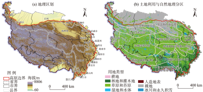
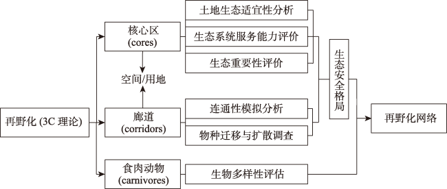
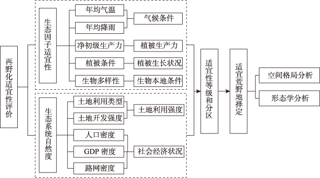
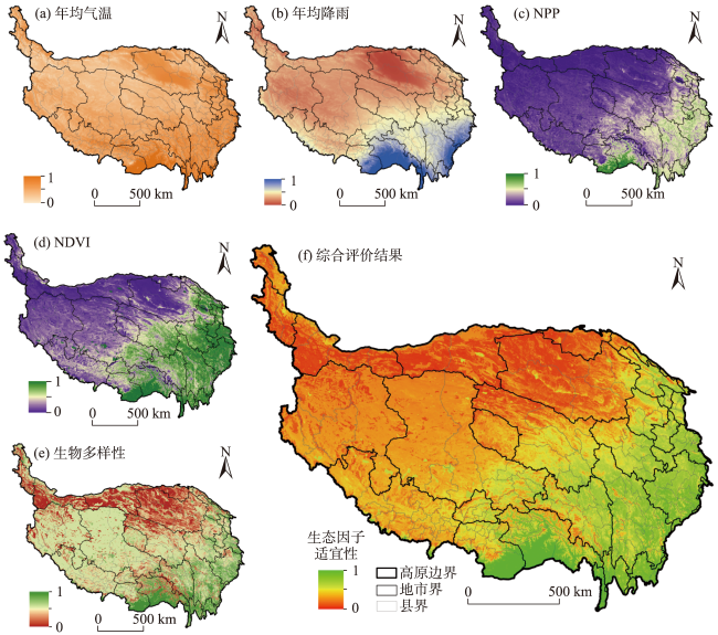
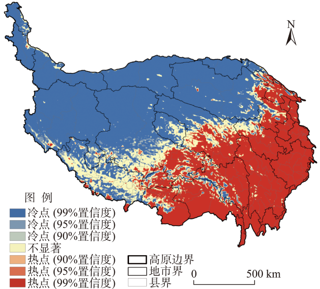
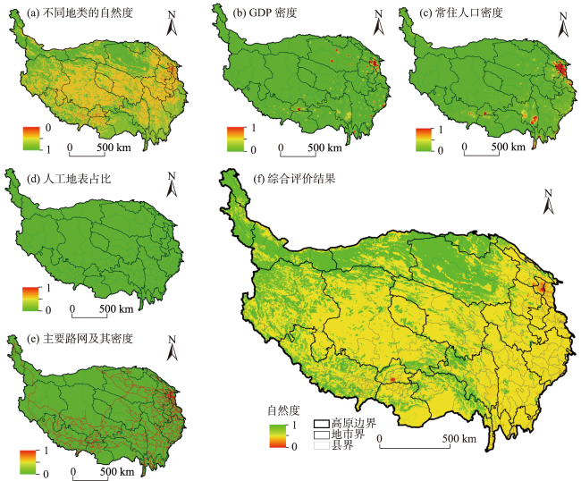
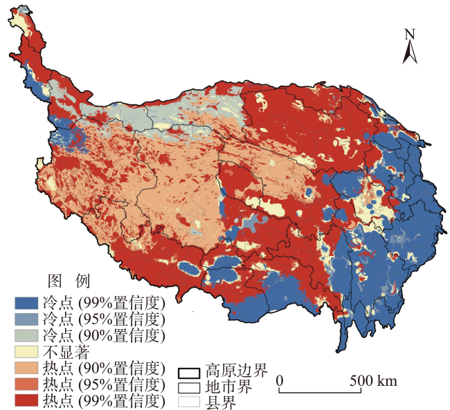
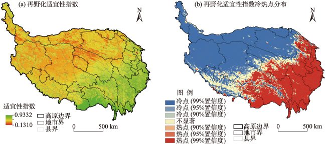
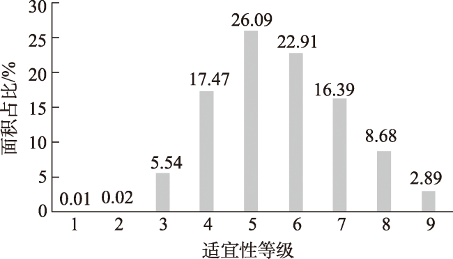
Rewilding is an important means of biodiversity conservation in the Anthropocene and under climate change. As the basic spatial carrier of rewilding, the scientific identification and protection of wilderness area is of great significance for improving the efficiency of biodiversity conservation. Taking the Qinghai-Tibet Plateau as a case area and using 2020 as the time point, this study analyzed the concept and connotation of wilderness, and comprehensively evaluated the suitability of rewilding from the two dimensions of ecological factor suitability and ecosystem naturalness by using the suitability assessment of rewilding, spatial pattern analysis of wilderness area, and morphological analysis. The results show that: 1) The suitability index of rewilding on the Qinghai-Tibet Plateau ranged from 0.1310 to 0.9332, and the spatial distribution of wilderness areas on the plateau showed obvious regional differentiation, with a spatial pattern of gradually declining from southeast to northwest. 2) The spatial structure of wilderness area was relatively simple, and the morphological characteristics were decentralized and large-scaled. The optimal wilderness area mainly concentrated in the evergreen broad-leaved forest belt of the southern wing of the eastern Himalaya, while the alternative and potential wilderness area gradually spread to the coniferous forest of the eastern mountains of Sichuan and Tibet, the grassland of the Qilian Mountains in eastern Qinghai, and the desert belt of the northern wing of the Kunlun Mountains in the northwest of the Qinghai-Tibet Plateau. 3) The optimization of wilderness area on the Qinghai-Tibet Plateau is affected by the distribution of important ecological functional zones, especially the source zones of large rivers. Influenced by its natural geographical conditions and human activities, the wilderness area on the Qinghai-Tibet Plateau is currently concentrated in the evergreen broad-leaved forest of the southern wing of the eastern Himalaya and the coniferous forest of the eastern mountains of Sichuan and Tibet in the east, while few and small in the source zones of large rivers in the west. The study results can provide a useful reference for improving the theory of conservation biology, optimizing the biodiversity conservation network, and enhancing the efficiency of biodiversity conservation on the Qinghai-Tibet Plateau.
LI Pingxing , LIANG Xin , ZHU Chuncheng . Suitability evaluation and spatial distribution characteristics of wilderness area on the Qinghai-Tibet Plateau[J]. PROGRESS IN GEOGRAPHY, 2024 , 43(4) : 727 -740 . DOI: 10.18306/dlkxjz.2024.04.008
表1 不同情景下荒野地景观格局指数Tab.1 Landscape pattern indices for wilderness areas under different scenarios |
| 情景 | TA/km² | NP/个 | 平均面积A′/km2 | PD/(个/hm2) | LPI/% |
|---|---|---|---|---|---|
| 情景a | 72649 | 5313 | 13.67 | 0.186 | 73.19 |
| 情景b | 291928 | 20761 | 14.06 | 0.725 | 63.40 |
| 情景c | 712018 | 35025 | 20.33 | 1.223 | 77.54 |
表2 不同情景下荒野地斑块形态指数Tab.2 Wilderness patch morphology indices under different scenarios |
| 情景 | D | c |
|---|---|---|
| 情景a | 1.1619 | 0.7619 |
| 情景b | 1.1770 | 0.7611 |
| 情景c | 1.1666 | 0.7582 |
表3 不同情景下荒野地面积分布情况Tab.3 Distribution of wilderness area under different scenarios |
| 情景 | 荒野地面积分布情况 | |||||||||||||
|---|---|---|---|---|---|---|---|---|---|---|---|---|---|---|
| ≥100 km2的斑块 | [50, 100) km2的斑块 | [10, 50) km2的斑块 | [1, 10) km2的斑块 | 小于1 km2的斑块 | ||||||||||
| 数量/个 | 面积/km2 | 数量/个 | 面积/km2 | 数量/个 | 面积/km2 | 数量/个 | 面积/km2 | 数量/个 | 面积/km2 | |||||
| 情景a | 15 | 61985 | 12 | 865 | 170 | 3210 | 1714 | 4256 | 3402 | 2333 | ||||
| 情景b | 65 | 248654 | 75 | 4921 | 595 | 11548 | 7158 | 17995 | 12868 | 8810 | ||||
| 情景c | 143 | 619247 | 164 | 11075 | 1557 | 30313 | 14331 | 38524 | 18830 | 12860 | ||||
| [1] |
UNEA. Resolution 73/284: United Nations decade on ecosystem restoration (2021-2030)[EB/OL]. 2019-03-06 [2023-06-25]. https://undocs.org/A/RES/73/284.
|
| [2] |
|
| [3] |
|
| [4] |
|
| [5] |
|
| [6] |
|
| [7] |
IUCN (International Union for Conservation of Nature), WCPA (World Commission on Protected Areas) Wilderness Specialist Group. Wilderness protected areas: Management guidelines 2016[EB/OL]. 2016-12-12 [2023-06-25]. https://www.iucn.org/news/protected-areas/201612/wilderness-protected-areas-management-guidelines.
|
| [8] |
|
| [9] |
曹越, 龙瀛, 杨锐. 中国大陆国土尺度荒野地识别与空间分布研究[J]. 中国园林, 2017, 33(6): 26-33.
[
|
| [10] |
|
| [11] |
|
| [12] |
|
| [13] |
张庆费, 贾熙璇, 郑思俊, 等. 城市工业区野境植物多样性与群落结构研究: 以原上海溶剂厂再野化为例[J]. 中国园林, 2021, 37(12): 14-19.
[
|
| [14] |
|
| [15] |
|
| [16] |
|
| [17] |
王宏新, 邵俊霖, 于姝婷, 等. 基于再野化理论的东北虎豹国家公园发展前瞻: 兼评荒野保护思想与实践[J]. 自然资源学报, 2021, 36(11): 2955-2965.
[
|
| [18] |
唐芳林, 田勇臣, 闫颜. 国家公园体制建设背景下的自然保护地体系重构研究[J]. 北京林业大学学报(社会科学版), 2021, 20(2): 1-5.
[
|
| [19] |
|
| [20] |
|
| [21] |
史同广, 郑国强, 王智勇, 等. 中国土地适宜性评价研究进展[J]. 地理科学进展, 2007, 26(2): 106-115.
[
|
| [22] |
喻忠磊, 张文新, 梁进社, 等. 国土空间开发建设适宜性评价研究进展[J]. 地理科学进展, 2015, 34(9): 1107-1122.
[
|
| [23] |
蔡玉梅, 董祚继, 邓红蒂, 等. FAO土地利用规划研究进展评述[J]. 地理科学进展, 2005, 24(1): 70-78.
[
|
| [24] |
张洪业. 利用限制性评分方法确定土地农业适宜性等级: 以澳大利亚新南维尔士州为例[J]. 地理研究, 1994, 13(2): 67-73.
[
|
| [25] |
王介勇, 刘彦随, 张富刚. 海南岛土地生态适宜性评价[J]. 山地学报, 2007, 25(3): 290-294.
[
|
| [26] |
|
| [27] |
|
| [28] |
刘庆芳, 卢文清, 戴特奇, 等. 考虑季节性的青藏高原地区公路可达性评价[J]. 地理科学进展, 2023, 42(4): 687-700.
[
|
| [29] |
郑度. 青藏高原自然地域系统研究[J]. 中国科学(地球科学), 1996, 26(4): 336-341.
[
|
| [30] |
|
| [31] |
杨锐, 曹越. “再野化”: 山水林田湖草生态保护修复的新思路[J]. 生态学报, 2019, 39(23): 8763-8770.
[
|
| [32] |
|
| [33] |
刘延国, 李景吉, 逯亚峰, 等. 西南山区生态保护红线划定方法优化: 基于生态地质环境脆弱性评估[J]. 生态学报, 2021, 41(14): 5825-5836.
[
|
| [34] |
|
| [35] |
|
| [36] |
张贇, 张银龙, 吴永波, 等. 自然度评价应用于城市生物多样性保护的研究进展[J]. 生态与农村环境学报, 2022, 38(6): 681-688.
[
|
| [37] |
|
| [38] |
侯伟, 翟亮, 田莉, 等. 基于PSR模型的景观人为干扰度综合分析: 以北京市为例[J]. 地理与地理信息科学, 2019, 35(6): 90-96.
[
|
| [39] |
|
| [40] |
杨宇, 刘毅, 金凤君, 等. 塔里木河流域绿洲城镇发展与水土资源效益分析[J]. 地理学报, 2012, 67(2): 157-168.
[
|
| [41] |
付慧, 刘艳军, 孙宏日, 等. 京津冀地区耕地利用转型时空分异及驱动机制[J]. 地理科学进展, 2020, 39(12): 1985-1998.
[
|
| [42] |
陈晓军, 刘庆生, 张宏业. 大城市边缘区建设用地空间分布格局的定量化测度研究[J]. 武汉大学学报(信息科学版), 2006, 31(3): 260-265.
[
|
| [43] |
贾文臣, 贾香云, 李福印, 等. 威海市土地利用分形特征动态变化[J]. 地理科学进展, 2009, 28(2): 193-198.
[
|
| [44] |
刘纪远, 王新生, 庄大方, 等. 凸壳原理用于城市用地空间扩展类型识别[J]. 地理学报, 2003, 58(6): 885-892.
[
|
| [45] |
|
| [46] |
|
/
| 〈 |
|
〉 |