
Hierarchical spatial pattern of urban agglomeration based on the dynamic and static data:A case study of the Yellow River Ji-shaped bend
Received date: 2022-12-06
Revised date: 2023-04-28
Online published: 2023-07-25
Supported by
The Key Program for Natural Sciences in Universities of Inner Mongolia(NJZZ23095)
Young Talents of Science and Technology in Universities of Inner Mongolia(NJTY-20-B09)
The Research Project on Social Sciences in Inner Mongolia(2022EY10)
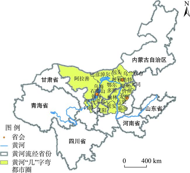
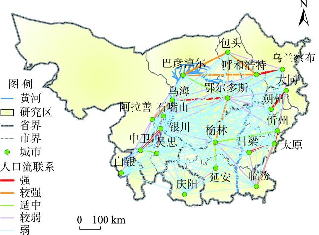
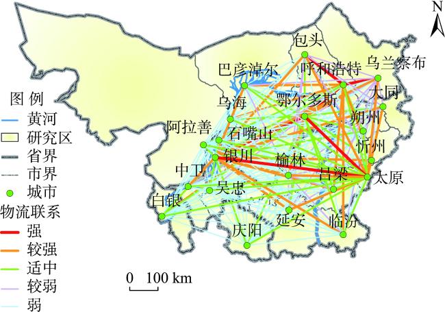
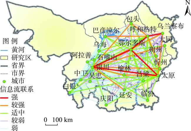
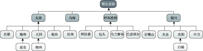
With the collaborative development of the urban agglomeration of the Yellow River Ji-shaped bend, it is of great scientific value to carry out the study of its spatial patterns. With the development of modern transportation, communication, and information technologies, the pattern of flow space based on dynamic element flow has become a research frontier. This study combined traditional static data and dynamic flow spatial data to examine the hierarchical spatial pattern of the urban agglomeration of the Yellow River Ji-shaped bend. The static data include the calculated comprehensive strength of the cities in the region, and the dynamic data are related to the dynamic flow space of three types of flows, namely population flow, logistics flow, and information flow. These elements were considered to make a comprehensive assessment of the multi-level spatial pattern of the urban agglomeration of the Yellow River Ji-shaped bend. This study found that: 1) There are some differences in the strength of spatial linkages among various types of flows in the region, where information flows are the strongest and there are strong linkages between information flows and other elemental flows. 2) Ordos is the dominant city in the urban agglomeration of the Yellow River Ji-shaped bend, and Yinchuan, Hohhot, Taiyuan, and Wuhai are the secondary dominant cities. Small city clusters centered on these cities have been formed in the region. In the future, the cities in this urban agglomeration should focus on strengthening the overall radiation capacity and spatial linkage strength to promote the rapid, coordinated, and comprehensive development of the urban agglomeration. This will eventually stimulate the urban network development from point to axis, and then to a "surface" in the urban agglomeration of the Yellow River Ji-shaped bend.
Key words: dynamic data; static data; Yellow River Ji-shaped bend; spatial pattern
WANG Fang , GUO Mengyao , NIU Fangqu . Hierarchical spatial pattern of urban agglomeration based on the dynamic and static data:A case study of the Yellow River Ji-shaped bend[J]. PROGRESS IN GEOGRAPHY, 2023 , 42(7) : 1243 -1255 . DOI: 10.18306/dlkxjz.2023.07.002
表1 城市综合实力评价指标体系Tab.1 Evaluation indicator system of comprehensive city strength |
| 目标层 | 一级指标 | 二级指标 | 指标性质 |
|---|---|---|---|
| 经济 | 经济实力 | 人均GDP(元) | + |
| 第三产业占比(%) | + | ||
| 经济活力 | 商业银行数量(个) | + | |
| 上市公司数量(个) | + | ||
| 市场规模 | 全社会固定资产投资(万元) | + | |
| 社会消费品零售总额(万元) | + | ||
| 城市建设 | 城市规模 | 建成区面积(km2) | + |
| 人口总量(万人) | + | ||
| 基础设施 | 人均城市道路面积(m2/人) | + | |
| 建成区供水管道密度(km/km2) | + | ||
| 燃气普及率(%) | + | ||
| 科技 | 科技投入 | R&D经费占GDP比重(%) | + |
| 科研力量 | 万人拥有高校数(所) | + | |
| 万人拥有发明专利数(个) | + | ||
| 吸引力 | 社会活力 | 百度指数 | + |
| 中心度 | 点度中心度 | + | |
| 中介中心度 | + |
表2 黄河“几”字弯都市圈流空间的空间关联性测试结果Tab.2 Results of spatial correlation test of flow spaces in the urban agglomeration of the Yellow River Ji-shaped bend |
| 流空间种类 | 人口流 | 信息流 | 物流 |
|---|---|---|---|
| 人口流 | — | 0.351* | 0.231* |
| 信息流 | 0.351* | — | 0.544* |
| 物流 | 0.231* | 0.544* | — |
注:*表示P <0.001;“—”表示没有数据。 |
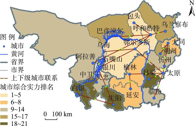
表3 黄河“几”字弯都市圈城市综合实力评价结果Tab.3 Evaluation results of comprehensive strength of cities in the urban agglomeration of the Yellow River Ji-shaped bend |
| 城市 | 城市综合实力评价得分 | 排名 | 城市 | 城市综合实力评价得分 | 排名 |
|---|---|---|---|---|---|
| 鄂尔多斯 | 0.650 | 1 | 忻州 | 0.202 | 12 |
| 太原 | 0.629 | 2 | 吴忠 | 0.201 | 13 |
| 呼和浩特 | 0.616 | 3 | 乌海 | 0.200 | 14 |
| 银川 | 0.502 | 4 | 朔州 | 0.196 | 15 |
| 包头 | 0.482 | 5 | 乌兰察布 | 0.173 | 16 |
| 榆林 | 0.361 | 6 | 巴彦淖尔 | 0.167 | 17 |
| 延安 | 0.301 | 7 | 吕梁 | 0.155 | 18 |
| 大同 | 0.284 | 8 | 庆阳 | 0.145 | 19 |
| 石嘴山 | 0.233 | 9 | 中卫 | 0.141 | 20 |
| 临汾 | 0.228 | 10 | 白银 | 0.141 | 21 |
| 阿拉善 | 0.208 | 11 |
| [1] |
方创琳. 中国城市群研究取得的重要进展与未来发展方向[J]. 地理学报, 2014, 69(8): 1130-1144.
[
|
| [2] |
顾朝林. 中国城市经济区划分的初步研究[J]. 地理学报, 1991, 46(2): 129-141.
[
|
| [3] |
习近平主持召开中央财经委员会第六次会议研究黄河流域生态保护和高质量发展等问题[J]. 中国水利, 2020(1): 4.
[Xi Jinping presided over the sixth meeting of the Central Finance and Economics Commission to study issues such as ecological protection and high-quality development of the Yellow River Basin. China Water Resources, 2020(1): 4.]
|
| [4] |
习近平. 在黄河流域生态保护和高质量发展座谈会上的讲话[J]. 水资源开发与管理, 2019(11): 1-4.
[
|
| [5] |
新华社. 中共中央国务院印发《黄河流域生态保护和高质量发展规划纲要》[J]. 中华人民共和国国务院公报, 2021(30): 15-35.
[Xinhua News Agency. The central committee of the CPC and the state council print and issue the outlines for the plan for ecological protection and high-quality development of the Yellow River Basin. Gazette of the State Council of the People's Republic of China, 2021(30): 15-35.]
|
| [6] |
习近平. 高举中国特色社会主义伟大旗帜为全面建设社会主义现代化国家而团结奋斗[N]. 人民日报, 2022-10-26( 1).
[
|
| [7] |
|
| [8] |
周一星, 史育龙. 建立中国城市的实体地域概念[J]. 地理学报, 1995, 50(4): 289-301.
[
|
| [9] |
崔功豪. 中国区域规划的新特点和发展趋势[J]. 现代城市研究, 2006(9): 4-7.
[
|
| [10] |
李小建, 李庆春. 克鲁格曼的主要经济地理学观点分析[J]. 地理科学进展, 1999, 18(2): 97-102.
[
|
| [11] |
史庆斌, 谢永顺, 韩增林, 等. 东北城市间旅游经济联系的空间结构及发展模式[J]. 经济地理, 2018, 38(11): 211-219.
[
|
| [12] |
郑伯铭, 刘安乐, 韩剑磊, 等. 云南省旅游经济联系网络结构演化与协同发展模式建构[J]. 经济地理, 2021, 41(2): 222-231.
[
|
| [13] |
李琬, 孙斌栋, 刘倩倩, 等. 中国市域空间结构的特征及其影响因素[J]. 地理科学, 2018, 38(5): 672-680.
[
|
| [14] |
肖泽平, 钟业喜, 冯兴华, 等. 长江中游城市群空间结构演变及效应分析[J]. 长江流域资源与环境, 2021, 30(11): 2607-2617.
[
|
| [15] |
王士君, 廉超, 赵梓渝. 从中心地到城市网络: 中国城镇体系研究的理论转变[J]. 地理研究, 2019, 38(1): 64-74.
[
|
| [16] |
甄峰, 王波, 陈映雪. 基于网络社会空间的中国城市网络特征: 以新浪微博为例[J]. 地理学报, 2012, 67(8): 1031-1043.
[
|
| [17] |
牛方曲, 王芳. 城市群形成理论建构与实证分析: 产业演进视角[J]. 城市与区域规划研究, 2021, 13(1): 99-112.
[
|
| [18] |
牛方曲, 刘卫东. 基于互联网大数据的区域多层次空间结构分析研究[J]. 地球信息科学学报, 2016, 18(6): 719-726.
[
|
| [19] |
|
| [20] |
王垚, 钮心毅, 宋小冬. “流空间”视角下区域空间结构研究进展[J]. 国际城市规划, 2017, 32(6): 27-33.
[
|
| [21] |
|
| [22] |
|
| [23] |
|
| [24] |
|
| [25] |
董超, 修春亮, 魏冶. 基于通信流的吉林省流空间网络格局[J]. 地理学报, 2014, 69(4): 510-519.
[
|
| [26] |
|
| [27] |
王娟, 李丽, 赵金金, 等. 基于国际酒店集团布局的中国城市网络连接度研究[J]. 人文地理, 2015, 30(1): 148-153.
[
|
| [28] |
|
| [29] |
|
| [30] |
宋琼, 赵新正, 李同昇, 等. 多重城市网络空间结构及影响因素: 基于有向多值关系视角[J]. 地理科学进展, 2018, 37(9): 1257-1267.
[
|
| [31] |
杨延杰, 尹丹, 刘紫玟, 等. 基于大数据的流空间研究进展[J]. 地理科学进展, 2020, 39(8): 1397-1411.
[
|
| [32] |
马学广, 窦鹏. 基于客运交通流的山东沿海城市带多中心结构特征研究[J]. 现代城市研究, 2017(10): 101-109.
[
|
| [33] |
蔡莉丽, 马学广, 陈伟劲, 等. 基于客运交通流的珠三角城市区域功能多中心特征研究[J]. 经济地理, 2013, 33(11): 52-57.
[
|
| [34] |
邱坚坚, 刘毅华, 陈浩然, 等. 流空间视角下的粤港澳大湾区空间网络格局: 基于信息流与交通流的对比分析[J]. 经济地理, 2019, 39(6): 7-15.
[
|
| [35] |
|
| [36] |
|
| [37] |
吴康敏, 张虹鸥, 叶玉瑶, 等. 粤港澳大湾区协同创新的综合测度与演化特征[J]. 地理科学进展, 2022, 41(9): 1662-1676.
[
|
| [38] |
|
| [39] |
周慧玲, 王甫园. 基于修正引力模型的中国省际旅游者流空间网络结构特征[J]. 地理研究, 2020, 39(3): 669-681.
[
|
| [40] |
杨勇, 眭霞芸, 刘震. 中国省际虚拟旅游流网络结构的空间演变特征研究[J]. 地理科学进展, 2022, 41(8): 1349-1363.
[
|
| [41] |
林志慧, 陈瑛, 刘宪锋, 等. 中国入境旅游城市合作网络时空格局及驱动因素[J]. 地理学报, 2022, 77(8): 2034-2049.
[
|
| [42] |
|
| [43] |
欧阳鹏, 郭继凯, 卢庆强, 等. 多尺度流空间视角下的超大城市对外协同治理研究: 以北京为例[J]. 规划师, 2022, 38(6): 41-50.
[
|
| [44] |
席广亮, 甄峰, 钱欣彤. 流动性视角下的国土空间安全及规划应对策略[J]. 自然资源学报, 2022, 37(8): 1935-1945.
[
|
| [45] |
周德, 戚佳玲, 钟文钰. 城乡融合评价研究综述: 内涵辨识、理论认知与体系重构[J]. 自然资源学报, 2021, 36(10): 2634-2651.
[
|
| [46] |
周佳宁, 毕雪昊, 邹伟. “流空间”视域下淮海经济区城乡融合发展驱动机制[J]. 自然资源学报, 2020, 35(8): 1881-1896.
[
|
| [47] |
|
| [48] |
曹炳汝, 孙巧. 产业集聚与城镇空间格局的耦合关系及时空演化: 以长三角区域为例[J]. 地理研究, 2019, 38(12): 3055-3070.
[
|
| [49] |
孙铁山. 中国三大城市群集聚空间结构演化与地区经济增长[J]. 经济地理, 2016, 36(5): 63-70.
[
|
| [50] |
吕拉昌, 孟国力, 黄茹, 等. 城市群创新网络的空间演化与组织: 以京津冀城市群为例[J]. 地域研究与开发, 2019, 38(1): 50-55.
[
|
| [51] |
|
| [52] |
|
| [53] |
王少剑, 高爽, 王宇渠. 基于流空间视角的城市群空间结构研究: 以珠三角城市群为例[J]. 地理研究, 2019, 38(8): 1849-1861.
[
|
| [54] |
徐珊, 甄峰. 省域城市网络中心性测度及比较研究: 以江苏省和广东省的对比分析为例[J]. 人文地理, 2021, 36(1): 135-144.
[
|
| [55] |
涂建军, 朱月, 李琪, 等. 基于网络空间结构的长江经济带城市影响区划定[J]. 经济地理, 2017, 37(12): 65-73.
[
|
| [56] |
薛峰, 马妍, 李苗裔. 多维消费流视角的海峡西岸经济区城市网络结构[J]. 经济地理, 2021, 41(5): 65-74.
[
|
| [57] |
王文学, 曹可心, 林静. 可持续城市多尺度评价框架及指标体系的研究进展与展望[J]. 城市发展研究, 2022, 29(11): 1-7.
[
|
| [58] |
宫攀, 王文哲, 吕承超. 城市综合发展的水平评价、时空格局与类型识别[J]. 统计与决策, 2022, 38(16): 30-35.
[
|
/
| 〈 |
|
〉 |