
Relationship between loess landslide deformation and river water level based on time series remote sensing images: A case study of the Qingquan Village landslide in Tianshui City
Received date: 2022-02-25
Revised date: 2022-09-09
Online published: 2023-02-24
Supported by
Strategic Priority Research Program of the Chinese Academy of Sciences (Class A)(XDA23090503)
Key Project of Innovation LREIS(KPI007)
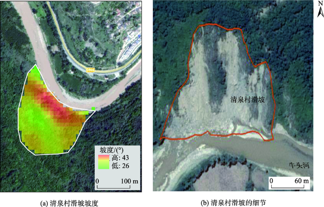
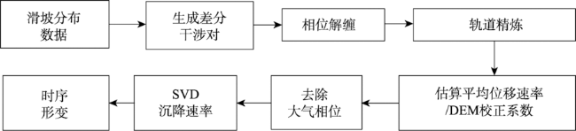
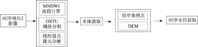
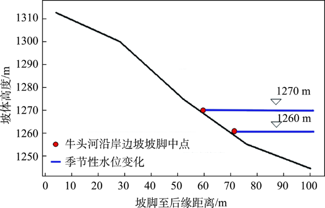
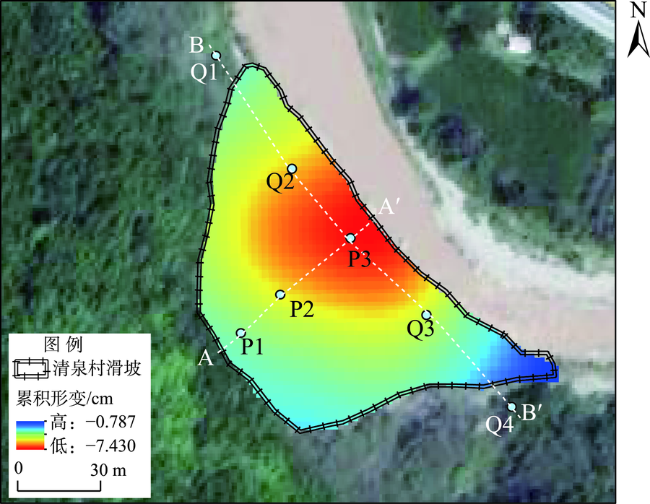
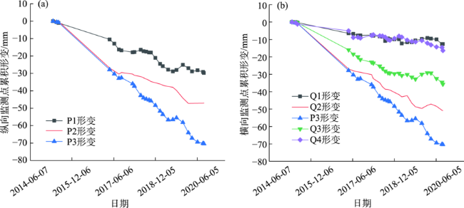
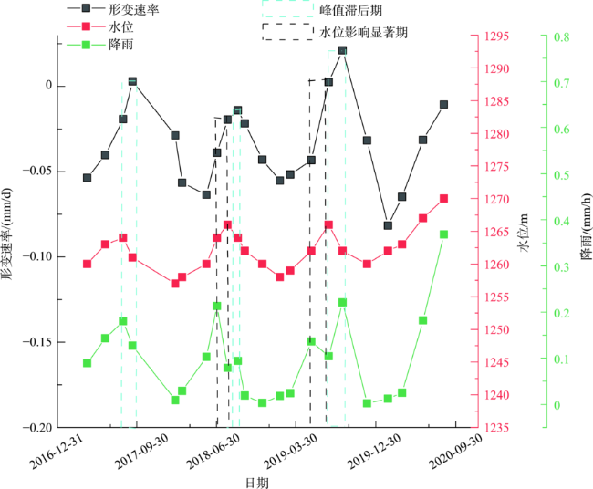
The erosion effect of rivers on the bank slopes is one of the important factors in the destabilization of loess landslides. Exploring the impact of seasonal changes of river water level on the stability of slopes is important for disaster early warning. The study utilized remote sensing techniques to examine the relationship between the rate of deformation of coastal slopes and seasonal changes in water levels over a five-year period, using the landslide in Qingquan Village, Tianshui City, Gansu Province as a case study. The time series deformation data of the landslide was obtained based on SBAS-InSAR technology, the time series water level data at the bottom of the slope was obtained using MNDWI and DEM, and the time series rainfall data of the study area was obtained through GPM. By comparing the river water level, time series rainfall, and landslide deformation rate curves, we found that as the rainfall increased and the river water level rose, the deformation rate of the Qingquan Village landslide increased significantly, and the landslide deformation rate increased the most during the summer season. In particular, the peak of the slope deformation rate has a certain lag compared to the peak of the water level. The coefficient of correlation between water level and landslide deformation was 0.46, and that between rainfall and landslide deformation was 0.39, indicating that the degree of response of the landslide in Qingquan Village to changes in water level was more pronounced. The seasonal change of river water level causes the seasonal change of river erosion on erosive landslides. The seasonal relationship between the deformation of loess landslides and the water levels of rivers is vital in understanding the evolution of riverbank slopes, recognizing landslides, and preventing disasters.
Key words: erosive landslide; landslide deformation; water level; correlation; loess landslide
YUN Yihan , ZHANG Mingbo , WU Yuming , YAO Jiaming . Relationship between loess landslide deformation and river water level based on time series remote sensing images: A case study of the Qingquan Village landslide in Tianshui City[J]. PROGRESS IN GEOGRAPHY, 2023 , 42(2) : 353 -363 . DOI: 10.18306/dlkxjz.2023.02.012
表1 数据影像参数信息Tab.1 Image parameters |
| 影像名称 | 影像信息 | 说明 |
|---|---|---|
| Sentinel-1A | 数据类型 | IW SLC |
| 升降轨 | Ascending | |
| 极化方式 | VV | |
| 影像时间段 | 2015年4月—2020年9月 | |
| 影像数量 | 24景 | |
| Sentinel-2 | 空间分辨率 | 10 m(4个波段)、20 m(6个波段)、60 m(3个波段) |
| 宽幅 | 290 km | |
| 视场 | 20.6° | |
| 影像时间段 | 2015年6月—2020年9月 | |
| 影像数量 | 52景 | |
| ALOS PALSAR DEM | 空间分辨率 | 12.5 m |
| GPM_3IMERGM | 空间分辨率 | 0.1° × 0.1° |
表2 哨兵2观测水位与北道水位站结果对比Tab.2 Comparison of Sentinel-2 observed water levels and results from the North Road water level station |
| 时间 | 哨兵2提取水位/m | 实测水位/m |
|---|---|---|
| 2018-04 | 1079 | 1075.43 |
| 2018-05 | 1079 | 1075.63 |
| 2018-06 | 1079 | 1075.60 |
| 2018-07 | 1080 | 1078.48 |
| 2018-08 | 1080 | 1076.10 |
| 2018-09 | 1079 | 1075.50 |
| 2018-10 | 1079 | 1075.23 |
表3 边坡形变与季节水位、时序降雨的相关系数Tab.3 Coefficients of correlation between slope deformation and seasonal water level and rainfall time series data |
| 指标 | 形变速率 | 时序降雨 | 季节水位 |
|---|---|---|---|
| 形变速率 | 1 | ||
| 时序降雨 | 0.39 | 1 | |
| 季节水位 | 0.46 | 0.5 | 1 |
感谢审稿专家对本文提出的宝贵意见以及刘洪江教授对本文结果分析方面的指导,在此一并感谢。
| [1] |
张茂省, 李同录. 黄土滑坡诱发因素及其形成机理研究[J]. 工程地质学报, 2011, 19(4): 530-540.
[
|
| [2] |
崔鹏. 中国山地灾害研究进展与未来应关注的科学问题[J]. 地理科学进展, 2014, 33(2): 145-152.
[
|
| [3] |
|
| [4] |
彭建兵, 王启耀, 庄建琦, 等. 黄土高原滑坡灾害形成动力学机制[J]. 地质力学学报, 2020, 26(5): 714-730.
[
|
| [5] |
廖红建, 盛谦, 高石夯, 等. 库水位下降对滑坡体稳定性的影响[J]. 岩石力学与工程学报, 2005, 24(19): 3454-3458.
[
|
| [6] |
张茂省, 胡炜, 孙萍萍, 等. 黄土水敏性及水致黄土滑坡研究现状与展望[J]. 地球环境学报, 2016, 7(4): 323-334.
[
|
| [7] |
孙萍萍, 张茂省, 冯立, 等. 黄土水敏性及其时空分布规律[J]. 西北地质, 2019, 52(2): 117-124.
[
|
| [8] |
王阿丹. 延安地区侵蚀作用导致的黄土滑坡形成机理研究[D]. 西安: 长安大学, 2012.
[
|
| [9] |
刘文红. 黄土高原滑坡发育背景与成灾模式研究[D]. 西安: 长安大学, 2016.
[
|
| [10] |
袁湘秦, 赵法锁, 段钊. 河流作用诱发黄土滑坡机理[J]. 煤田地质与勘探, 2018, 46(4): 154-160.
[
|
| [11] |
张吉宏, 段钊, 唐皓. 蠕变对河流侧蚀型黄土滑坡影响的数值模拟[J]. 人民黄河, 2020, 42(2): 142-146.
[
|
| [12] |
|
| [13] |
|
| [14] |
安炳琪, 罗海滨, 丁海勇, 等. 基于SBAS-InSAR技术的西宁地表形变监测[J]. 遥感技术与应用, 2021, 36(4): 838-846.
[
|
| [15] |
|
| [16] |
冯文凯, 顿佳伟, 易小宇, 等. 基于SBAS-InSAR技术的金沙江流域沃达村巨型老滑坡形变分析[J]. 工程地质学报, 2020, 28(2): 384-393.
[
|
| [17] |
姚佳明, 姚鑫, 刘星洪, 等. InSAR技术的天水市活动性滑坡灾害识别与分析[J]. 测绘科学, 2022, 47(1): 121-132.
[
|
| [18] |
宋森森, 贾振红, 杨杰, 等. 结合OSTU阈值法的最小生成树图像分割算法[J]. 计算机工程与应用, 2019, 55(9): 178-183.
[
|
| [19] |
赵紫薇. 基于OSTU算法利用新型水体指数进行Landsat数据自适应阈值水体自动提取研究[J]. 测绘与空间地理信息, 2016, 39(9): 57-60.
[
|
| [20] |
周晗, 叶虎平, 魏显虎, 等. 基于Sentinel-1/2的水体提取方法对比研究: 以斯里兰卡小型水体为例[J]. 中国科学院大学学报, 2019, 36(6): 794-802.
[
|
| [21] |
王大钊, 王思梦, 黄昌. Sentinel-2和Landsat 8影像的四种常用水体指数地表水体提取对比[J]. 国土资源遥感, 2019, 31(3): 157-165.
[
|
| [22] |
姚杰鹏, 杨磊库, 陈探, 等. 基于Sentinel-1, 2和Landsat 8时序影像的鄱阳湖湿地连续变化监测研究[J]. 遥感技术与应用, 2021, 36(4): 760-776.
[
|
| [23] |
|
| [24] |
|
| [25] |
|
| [26] |
|
| [27] |
|
| [28] |
徐涵秋. 利用改进的归一化差异水体指数(MNDWI)提取水体信息的研究[J]. 遥感学报, 2005, 9(5): 589-595.
[
|
| [29] |
刘成, 王丹丽, 李笑梅. 用混合像元线性模型提取中等植被覆盖区的粘土蚀变信息[J]. 遥感技术与应用, 2003, 18(2): 95-98.
[
|
| [30] |
金鑫, 柯长青. 基于混合像元分解的天山典型地区冰雪变化监测[J]. 国土资源遥感, 2012, 24(4): 146-151.
[
|
| [31] |
周永健, 冯文凯, 易小宇, 等. 木鱼包滑坡变形与库水位相关性定量化分析[J]. 科学技术与工程, 2021, 21(27): 11544-11550.
[
|
| [32] |
尚敏, 廖芬, 马锐, 等. 白家包滑坡变形与库水位、降雨相关性定量化分析研究[J]. 工程地质学报, 2021, 29(3): 742-750.
[
|
| [33] |
慕焕东, 邓亚虹, 李荣建. 干湿循环对地裂缝带黄土抗剪强度影响研究[J]. 工程地质学报, 2018, 26(5): 1131-1138.
[
|
| [34] |
李保雄, 苗天德. 黄土抗剪强度的水敏感性特征研究[J]. 岩石力学与工程学报, 2006, 25(5): 1003-1008.
[
|
| [35] |
朱赛楠, 殷跃平, 黄波林, 等. 三峡库区大型单斜顺层新生滑坡变形特征与失稳机理研究[J]. 工程地质学报, 2021, 29(3): 657-667.
[
|
| [36] |
周永娟, 仇江啸, 王效科, 等. 三峡库区消落带崩塌滑坡脆弱性评价[J]. 资源科学, 2010, 32(7): 1301-1307.
[
|
| [37] |
张鹏, 张森林, 黄波林, 等. 岸坡消落带岩体劣化的新生型滑坡(崩塌)隐患演化模式研究[J]. 工程地质学报, 2021, 29(5):1416-1426.
[
|
| [38] |
|
| [39] |
赵萌. 三峡库区黄土坡滑坡滑带土特性及失稳机理研究[D]. 武汉: 中国地质大学, 2021.
[
|
| [40] |
邓华锋, 肖瑶, 方景成, 等. 干湿循环作用下岸坡消落带土体抗剪强度劣化规律及其对岸坡稳定性影响研究[J]. 岩土力学, 2017, 38(9): 2629-2638.
[
|
/
| 〈 |
|
〉 |