
City image perception of Xi’an based on unmanned aerial vehicle photography photos
Received date: 2020-09-24
Revised date: 2021-02-04
Online published: 2021-11-28
Supported by
Tang Scholar Program of Northwest University(2016)
College Students Innovation and Entrepreneurship Training Program of Shaanxi Province(2020281)
Copyright
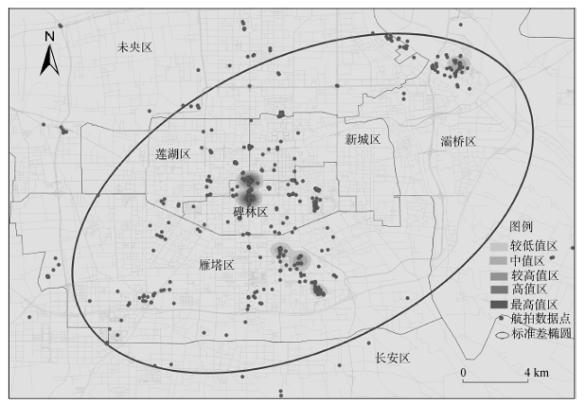
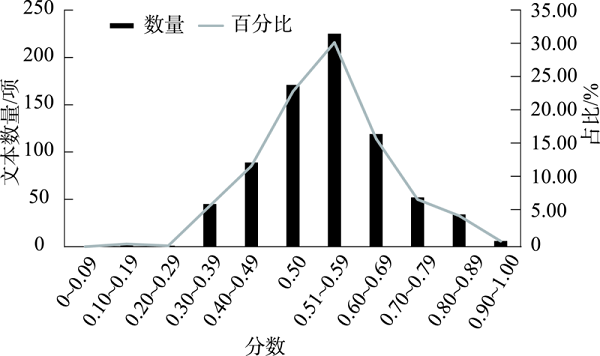
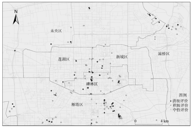
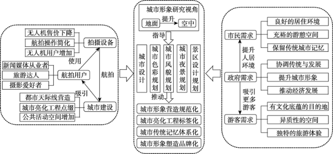
With the rapid development of civilian unmanned aerial vehicle (UAV) technology, UAV aerial photography has become an important data source for urban image perception research. Based on the photos, text introduction, shooting location, and related data of UAVs photos of Xi'an City obtained from the social media platform SkyPixel, this study used computer vision analysis, computer text emotion analysis, social network analysis, and GIS spatial analysis to explore the city image of Xi'an from the perspective of UAV. The research results show that: 1) UAV aerial photography photos are mainly concentrated in the main urban areas, and there are fewer aerial data points in the suburb. The spatial distribution of photos presents a pattern of dense inside and sparse outside, with the highest density area in the center of the city at the junction zone of the three districts, showing a dumbbell-type distribution extending from the north to south. 2) The visual images are mostly of modern urban landscape description, of which the content of human landscape is dominant. 3) Emotion evaluation presents an overall positive feeling, and the polarization of the popular tourist attractions is obvious in the main urban area. Finally, this study explored the mechanism of city image formation and promotion from the perspective of UAV, and provided recommendations for the optimization of Xi'an city image construction and UAV use policy.
Key words: city image; visual analysis; UAV; aerial photography photos; Xi'an City
CHEN Xiliang , LI Gang , XU Feng , YU Yue , ZHANG Qianxi . City image perception of Xi’an based on unmanned aerial vehicle photography photos[J]. PROGRESS IN GEOGRAPHY, 2021 , 40(9) : 1600 -1612 . DOI: 10.18306/dlkxjz.2021.09.014
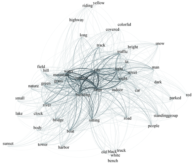
表1 计算机视觉分析西安市无人机航拍照片内容关键词统计(前56项)Tab.1 Keyword statistics of the content of UAV photography photos based on computer vision analysis in Xi'an City (Top 56) |
| 序号 | 关键词 | 词频 | 比重/% | 序号 | 关键词 | 词频 | 比重/% |
|---|---|---|---|---|---|---|---|
| 1 | outdoor | 729 | 7.04 | 29 | bridge | 52 | 0.50 |
| 2 | large | 677 | 6.53 | 30 | colorful | 51 | 0.49 |
| 3 | city | 613 | 5.92 | 31 | white | 51 | 0.49 |
| 4 | building | 509 | 4.91 | 32 | body | 50 | 0.48 |
| 5 | water | 432 | 4.17 | 33 | small | 48 | 0.46 |
| 6 | light | 415 | 4.01 | 34 | harbor | 47 | 0.45 |
| 7 | night | 379 | 3.66 | 35 | yellow | 45 | 0.43 |
| 8 | sitting | 361 | 3.48 | 36 | old | 43 | 0.42 |
| 9 | street | 256 | 2.47 | 37 | lake | 42 | 0.41 |
| 10 | traffic | 216 | 2.08 | 38 | red | 42 | 0.41 |
| 11 | grass | 199 | 1.92 | 39 | indoor | 41 | 0.40 |
| 12 | road | 195 | 1.88 | 40 | highway | 38 | 0.37 |
| 13 | lit | 187 | 1.81 | 41 | truck | 37 | 0.36 |
| 14 | mountain | 176 | 1.70 | 42 | riding | 35 | 0.34 |
| 15 | track | 126 | 1.22 | 43 | bench | 34 | 0.33 |
| 16 | boat | 125 | 1.21 | 44 | group | 34 | 0.33 |
| 17 | green | 119 | 1.15 | 45 | people | 33 | 0.32 |
| 18 | river | 109 | 1.05 | 46 | black | 30 | 0.29 |
| 19 | snow | 98 | 0.95 | 47 | park | 30 | 0.29 |
| 20 | car | 89 | 0.86 | 48 | clock | 29 | 0.28 |
| 21 | man | 86 | 0.83 | 49 | tower | 29 | 0.28 |
| 22 | field | 73 | 0.70 | 50 | fireworks | 28 | 0.27 |
| 23 | nature | 69 | 0.67 | 51 | front | 28 | 0.27 |
| 24 | standing | 69 | 0.67 | 52 | bright | 25 | 0.24 |
| 25 | hill | 63 | 0.61 | 53 | parked | 25 | 0.24 |
| 26 | covered | 59 | 0.57 | 54 | sunset | 25 | 0.24 |
| 27 | dark | 59 | 0.57 | 55 | valley | 25 | 0.24 |
| 28 | long | 59 | 0.57 | 56 | cloudy | 24 | 0.23 |
表2 西安市无人机航拍照片视觉内容关键词分类Tab.2 Keyword classification of visual content of UAV photography photos in Xi'an City |
| 分类 | 占比/% | 关键词 |
|---|---|---|
| 人文景观 | 25.21 | city, building, lit, bench, park, clock, tower, fireworks, light |
| 形容词 | 23.49 | outdoor, large, standing, old, small, indoor, bright, long, covered, front |
| 自然景观 | 22.65 | water, grass, mountain, river, snow, field, nature, hill, lake, sunset, valley, night, cloudy |
| 交通 | 15.49 | street, traffic, road, track, car, bridge, harbor, highway, boat, truck, parked |
| 人物及活动 | 7.91 | sitting, body, man, people, riding, group |
| 色彩 | 5.25 | green, white, yellow, colorful, red, black, dark |
| [1] |
|
| [2] |
|
| [3] |
|
| [4] |
龙瀛, 周垠. 图片城市主义: 人本尺度城市形态研究的新思路[J]. 规划师, 2017, 33(2):54-60.
[
|
| [5] |
|
| [6] |
|
| [7] |
|
| [8] |
|
| [9] |
|
| [10] |
|
| [11] |
|
| [12] |
|
| [13] |
|
| [14] |
|
| [15] |
毕凯, 李英成, 丁晓波, 等. 轻小型无人机航摄技术现状及发展趋势[J]. 测绘通报, 2015(3):27-31, 48.
[
|
| [16] |
余忠迪, 李辉, 巴芳, 等. 基于消费者级无人机的城市三维建模[J]. 国土资源遥感, 2018, 30(2):67-72.
[
|
| [17] |
杨存建, 李何超, 许光洪, 等. 基于大疆无人机遥感的农村居民点建筑密度与容积率的测算[J]. 山地学报, 2019, 37(1):144-150.
[
|
| [18] |
李德仁, 李明. 无人机遥感系统的研究进展与应用前景[J]. 武汉大学学报(信息科学版), 2014, 39(5):505-513, 540.
[
|
| [19] |
曾凡洋, 李长辉, 宋杨, 等. 微型无人机在违法用地与违法建设动态监测中的应用[J]. 测绘通报, 2017(S1):152-154, 168.
[
|
| [20] |
柳彤. 无人机在城市动态监测中的应用研究[J]. 科技视界, 2019(18):70-71.
[
|
| [21] |
郑国. 基于地方文脉的城市形象定位研究: 以河北白沟为例[J]. 城市发展研究, 2010, 17(11):77-81.
[
|
| [22] |
|
| [23] |
刘卫梅, 林德荣. 旅游城市形象和情感联结对旅游意愿的影响[J]. 城市问题, 2018(8):95-103.
[
|
| [24] |
张鸿雁. 城市形象与城市文化资本论:中外城市形象比较的社会学研究[M]. 南京: 东南大学出版社, 2002.
[
|
| [25] |
张鸿雁. 城市意象要素的本土化文化认知[J]. 城市问题, 2004(5):6-11, 22.
[
|
| [26] |
彭靖里, 马敏象, 安华轩. 中国城市形象建设的发展现状及其展望[J]. 中国软科学, 1999(2):3-5.
[
|
| [27] |
伍海琳. 城市旅游形象策划与提升研究 [M]. 上海: 上海交通大学出版社, 2011.
[
|
| [28] |
|
| [29] |
周永博, 沙润, 余子萍. 旅游目的地意象三维耦合结构: 基于江南水乡古镇旅游者的实证分析[J]. 地理科学进展, 2010, 29(12):1590-1596.
[
|
| [30] |
李萍, 陈田, 王甫园, 等. 基于文本挖掘的城市旅游社区形象感知研究: 以北京市为例[J]. 地理研究, 2017, 36(6):1106-1122.
[
|
| [31] |
赵政原, 刘志高. 演化经济地理学视角下旅游目的地研究述评及启示[J]. 地理科学进展, 2019, 38(1):101-110.
[
|
| [32] |
江金波, 赫瑞娜. 基于结构方程模型的城市旅游形象影响路径研究: 以西安市为例[J]. 人文地理, 2015, 30(3):130-136.
[
|
| [33] |
徐小波, 赵磊, 刘滨谊, 等. 中国旅游城市形象感知特征与分异[J]. 地理研究, 2015, 34(7):1367-1379.
[
|
| [34] |
陆利军, 廖小平. 基于UGC数据的南岳衡山旅游目的地形象感知研究[J]. 经济地理, 2019, 39(12):221-229.
[
|
| [35] |
徐菲菲, 剌利青,
[
|
| [36] |
曹兴平, 贺涵, 冯琴, 等. 基于游客照片的皖南古村落目的地意象: 以安徽宏村为例[J]. 资源科学, 2020, 42(5):933-945.
[
|
| [37] |
|
| [38] |
王敏, 江荣灏, 朱竑. 人文地理学的“视觉”研究进展与启示[J]. 人文地理, 2017, 32(3):10-19.
[
|
| [39] |
|
| [40] |
|
| [41] |
邓宁, 刘耀芳, 牛宇, 等. 不同来源地旅游者对北京目的地形象感知差异: 基于深度学习的Flickr图片分析[J]. 资源科学, 2019, 41(3):416-429.
[
|
| [42] |
|
| [43] |
|
| [44] |
|
| [45] |
|
| [46] |
|
| [47] |
|
| [48] |
|
| [49] |
苟思远, 李钢, 张可心, 等. 基于自媒体平台的“旅游者”时空行为研究: 以W教授的微信“朋友圈”为例[J]. 旅游学刊, 2016, 31(8):71-80.
[
|
| [50] |
王满四, 周翔, 张延平. 从产品导向到服务导向: 传统制造企业的战略更新: 基于大疆创新科技有限公司的案例研究[J]. 中国软科学, 2018(11):107-121.
[
|
| [51] |
徐宝达, 赵树宽, 张健. 基于社会网络分析的微信公众号信息传播研究[J]. 情报杂志, 2017, 36(1):120-126.
[
|
| [52] |
|
| [53] |
|
| [54] |
|
| [55] |
|
| [56] |
黄燕, 赵振斌, 褚玉杰, 等. 互联网时代的旅游地视觉表征: 多元建构与循环[J]. 旅游学刊, 2015, 30(6):91-101.
[
|
| [57] |
|
/
| 〈 |
|
〉 |