
High-resolution monitoring of glacier dynamics based on unmanned aerial vehicle survey in the Meili Snow Mountain
Received date: 2020-08-03
Revised date: 2020-09-29
Online published: 2021-11-28
Supported by
National Natural Science Foundation of China(41801031)
National Natural Science Foundation of China(41761144075)
Natural Science Foundation of Yunnan Province(202001BB050068)
The State Key Laboratory of Cryospheric Science Foundation(SKLCS-OP-2019-07)
The Second Tibetan Plateau Scientific Expedtion and Research Program(2019QZKK0208)
A Grant for Talent Introduction of Yunnan University(YJRC3201702)
Copyright
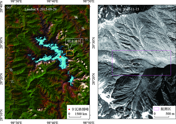
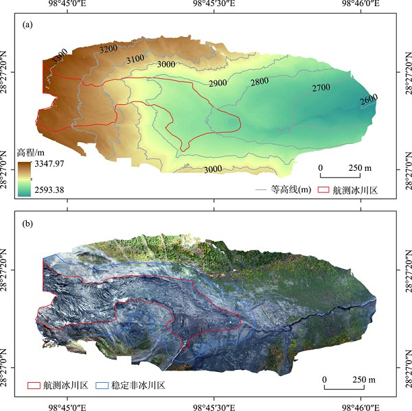
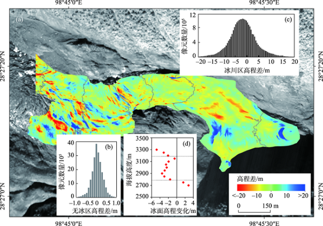
The glaciers of the Meili Snow Mountain are now rapidly retreating and thinning, owing to climate change. The main aim of this study was to monitor the dynamics of the Mingyong Glacier in the Meili Snow Mountain based on unmanned aerial vehicle (UAV) survey and UBase. The result of the digital surface model (DSM) in the Mingyong Glacier terminus shows that the surface morphology has a significant difference between the upper and lower sections. The lower section was covered by a large amount of debris, and a few crevasses developed along the direction of glacier flow. Little debris was found in the upper section, and a lot of transverse crevasses developed there. A mean ice thinning of 1.67 m was observed in the terminus of the Mingyong Glacier from November 2018 to November 2019, and surface lowering was heterogeneous. There were positive and negative alternations in surface lowering in the upper section, surface thinning was observed in the middle section, while a significant thickening was observed in the lower section. Compared with glacier changes in other areas in the High Asia Mountains, the Meili Snow Mountain was the region with the most significant glacier surface elevation change.
Key words: unmanned aerial vehicle; photogrammetry; glacier; Meili Snow Mountain
WU Kunpeng , LIU Shiyin , ZHU Yu , XIE Fuming , GAO Yongpeng . High-resolution monitoring of glacier dynamics based on unmanned aerial vehicle survey in the Meili Snow Mountain[J]. PROGRESS IN GEOGRAPHY, 2021 , 40(9) : 1581 -1589 . DOI: 10.18306/dlkxjz.2021.09.012
表1 正射影像、DSM影像与相控点精度对比Tab.1 Accuracy of orthoimage, DSM and control points (m) |
| 相控点ID | X方向 | Y方向 | Z方向 |
|---|---|---|---|
| 1 | 0.228 | 0.026 | -0.570 |
| 2 | 0.120 | 0.007 | 0.457 |
| 3 | -0.034 | -0.248 | -0.377 |
| 4 | -0.170 | 0.413 | 0.431 |
| 5 | -0.161 | -0.140 | -0.423 |
| 平均误差(EM) | ±0.003 | ±0.012 | ±0.096 |
| 均方根误差(ER) | ±0.055 | ±0.110 | ±0.310 |
表2 高亚洲地区典型山地冰川变化Tab.2 A summary of glacier surface elevation changes in the High Asia Mountains |
| 研究区 | 时段 | 冰川表面高程 变化/(m·a-1) | 文献来源 |
|---|---|---|---|
| 天山 | 2000—2012年 | -0.40 ± 0.22 | [31] |
| 帕米尔 | 2000—2011年 | -0.02 ± 0.13 | [15] |
| 喀喇昆仑山 | 2000—2011年 | -0.33 ± 0.16 | [15] |
| 西昆仑山 | 2003—2009年 | 0.04 ± 0.29 | [32] |
| 青藏高原内流区 | 2003—2009年 | -0.05 ± 0.26 | [32] |
| 唐古拉山 | 2003—2009年 | -0.68 ± 0.35 | [32] |
| 喜马拉雅山 | 2003—2009年 | -1.15 ± 0.44 | [32] |
| 念青唐古拉山 | 2000—2014年 | -1.50 ± 0.15 | [30] |
| 梅里雪山 | 2018—2019年 | -1.67 ± 0.05 | 本文 |
| [1] |
|
| [2] |
|
| [3] |
IPCC. Climate change 2013: The physical science basis. Contribution of Working Group I to the Fifth Assessment Report of the Intergovernmental Panel on Climate Change[M]. Cambridge, UK: Cambridge University Press, 2013.
|
| [4] |
秦大河, 姚檀栋, 丁永建, 等. 冰冻圈科学概论[M]. 北京: 科学出版社, 2017.
[
|
| [5] |
姚檀栋, 邬光剑, 徐柏青, 等. “亚洲水塔”变化与影响[J]. 中国科学院院刊, 2019, 34(11):1203-1209.
[
|
| [6] |
|
| [7] |
崔鹏, 郭晓军, 姜天海, 等. “亚洲水塔”变化的灾害效应与减灾对策[J]. 中国科学院院刊, 2019, 34(11):1313-1321.
[
|
| [8] |
邬光剑, 姚檀栋, 王伟财, 等. 青藏高原及周边地区的冰川灾害[J]. 中国科学院院刊, 2019, 34(11):1285-1292.
[
|
| [9] |
|
| [10] |
|
| [11] |
|
| [12] |
|
| [13] |
|
| [14] |
|
| [15] |
|
| [16] |
|
| [17] |
|
| [18] |
施雅风, 刘朝海, 王宗太, 等. 简明中国冰川目录 [M]. 上海: 上海科学普及出版社, 2005.
[
|
| [19] |
|
| [20] |
|
| [21] |
|
| [22] |
|
| [23] |
车彦军, 王世金, 刘婧. 无人机在冰川复杂地形监测中的应用: 以玉龙雪山白水河1号冰川为例[J]. 冰川冻土, 2020, 42(4):1391-1399.
[
|
| [24] |
刘宇硕, 秦翔, 郭万钦, 等. 控制点布设对冰川区无人机摄影测量精度的影响[J]. 遥感学报, 2020, 24(2):161-172.
[
|
| [25] |
蓝永如, 刘高焕, 邵雪梅. 近40a来基于树轮年代学的梅里雪山明永冰川变化研究[J]. 冰川冻土, 2011, 33(6):1229-1234.
[
|
| [26] |
欧晓昆, 张志明, 王崇云. 梅里雪山植被研究 [M]. 北京: 科学出版社, 2006.
[
|
| [27] |
郑本兴, 赵希涛, 李铁松, 等. 梅里雪山明永冰川的特征与变化[J]. 冰川冻土, 1999, 21(2):145-150.
[
|
| [28] |
谢自楚, 刘潮海. 冰川学导论 [M]. 上海: 上海科学普及出版社, 2010.
[
|
| [29] |
卞敏, 徐亮, 骆元鹏, 等. 空地一体精细化三维模型构建方法[J]. 测绘通报, 2019(7):83-86.
[
|
| [30] |
|
| [31] |
|
| [32] |
|
/
| 〈 |
|
〉 |