
Evaluation of green space accessibility based on improved Gaussian two-step floating catchment area method: A case study of Shenzhen City, China
Received date: 2020-09-21
Request revised date: 2021-01-18
Online published: 2021-09-28
Supported by
National Natural Science Foundation of China(41971205)
National Natural Science Foundation of China(41771204)
Tiehan Scientific Research Open Fund of Laboratory for Urban Future Peking University(201701)
Copyright
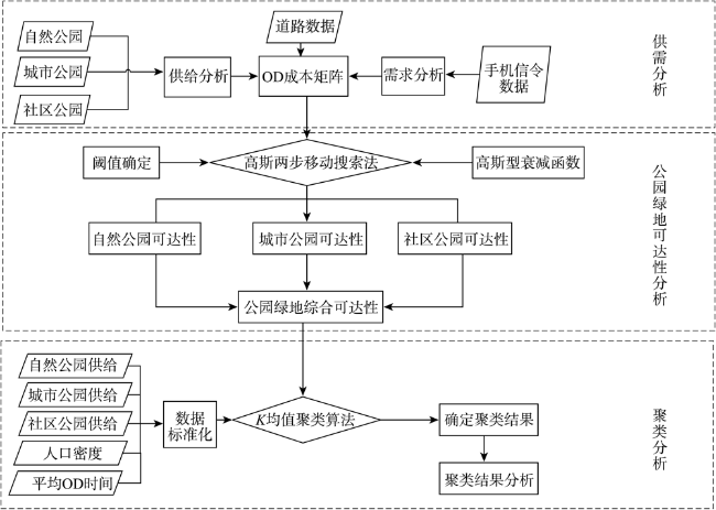
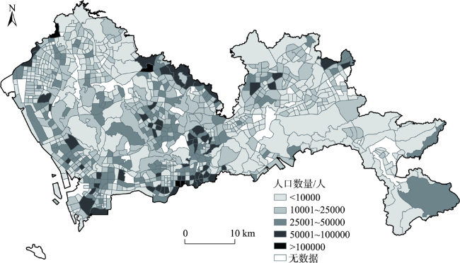
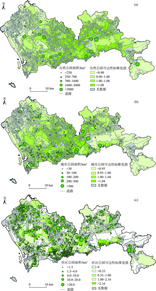
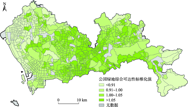
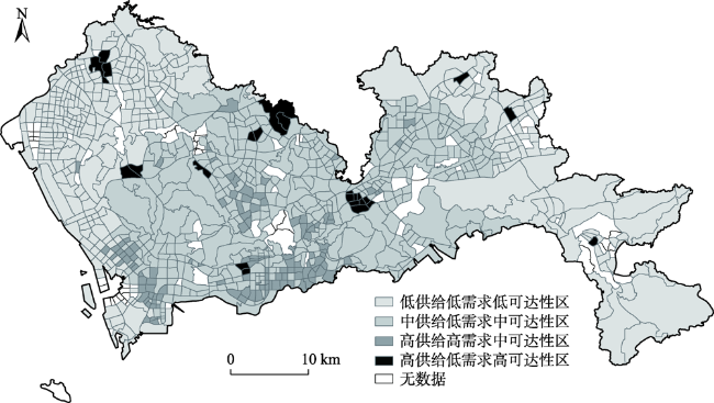
Accessibility of park green space is an important indicator of the livability level of a city. In order to solve the problem of scale imbalance between population and park green space distribution data by traditional accessibility analysis, this study used mobile phone signaling data to obtain the spatial distribution of population, and adopted the Gaussian two-step floating catchment area method to calculate the accessibility of park green space at the scale of traffic analysis zone (TAZ) in Shenzhen City. It also conducted a cluster analysis based on the accessibility results, supply and demand, and traffic conditions. The main conclusions are as follows: 1) More refined population information can be obtained through mobile phone signaling data to improve the accuracy of demand assessment. For different types of parks, the Gaussian two-step floating catchment area method represents an improvement in calculating the accessibility of parks in the city. 2) The overall level of comprehensive accessibility of park green space in Shenzhen is relatively high, but there is an obvious decreasing trend from the city center to the periphery. The mismatch between the accessibility of community parks and the supply and demand of park green space is an important reason for the large difference of accessibility among different regions in Shenzhen. 3) According to the results ofK-means clustering analysis, the TAZ units of the city was divided into low supply low demand low accessibility zone, medium supply low demand medium accessibility zone, high supply high demand medium accessibility zone, and high supply low demand high accessibility zone. 4) The accessibility of park green space can be improved by optimizing park layout, road construction, and residential area planning and layout. By improving data source and model of the traditional accessibility calculation, this study enriches the cases of park green space accessibility evaluation, and the proposed accessibility analysis method based on mobile phone signaling can also provide a reference for the accessibility analysis of other geographic phenomenon.
TONG De , SUN Yiyu , XIE Miaomiao . Evaluation of green space accessibility based on improved Gaussian two-step floating catchment area method: A case study of Shenzhen City, China[J]. PROGRESS IN GEOGRAPHY, 2021 , 40(7) : 1113 -1126 . DOI: 10.18306/dlkxjz.2021.07.004
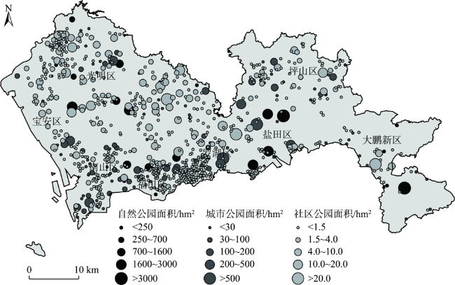
表1 深圳市各行政区公园绿地面积汇总Tab.1 Summary of park green space area in Shenzhen City |
| 区名 | 自然公园面积/hm2 | 城市公园面积/hm2 | 社区公园面积/hm2 | 总公园面积/hm2 | |
|---|---|---|---|---|---|
| 大鹏新区 | 5279.69 | 125.85 | 52.53 | 5458.07 | |
| 罗湖区 | 1577.41 | 1086.06 | 64.13 | 2727.60 | |
| 盐田区 | 4533.18 | 461.04 | 30.93 | 5025.15 | |
| 龙岗区 | 186.28 | 2347.74 | 202.91 | 2736.93 | |
| 坪山区 | 4771.17 | 251.36 | 40.51 | 5063.04 | |
| 福田区 | 1751.55 | 788.73 | 70.44 | 2610.72 | |
| 南山区 | 2473.59 | 1171.90 | 74.77 | 3720.26 | |
| 宝安区 | 2752.27 | 729.60 | 258.86 | 3740.73 | |
| 光明区 | 1268.12 | 428.15 | 85.85 | 1782.12 | |
| 龙华区 | 1407.46 | 82.37 | 274.31 | 1764.14 | |
| 合计 | 26000.72 | 7472.80 | 1155.24 | 34628.76 | |
| (占比) | (75.08%) | (21.58%) | (3.34%) | (100%) | |
表2 公园绿地可达性及其影响因子最终聚类中心Tab.2 Final cluster centers of accessibility and influencing factors of park green space |
| 类别 | TAZ个数 | 综合可达性 | 人口密度 | 平均OD时间 | 自然公园供给 | 城市公园供给 | 社区公园供给 |
|---|---|---|---|---|---|---|---|
| 低供给低需求低可达性区 | 344 | -0.25 | -0.33 | 0.94 | -0.99 | -1.06 | -0.13 |
| 中供给低需求中可达性区 | 415 | 0.08 | -0.28 | -0.53 | 0.67 | 0.69 | -0.21 |
| 高供给高需求中可达性区 | 122 | 0.03 | 1.93 | -0.81 | 0.42 | 0.69 | 0.20 |
| 高供给低需求高可达性区 | 24 | 0.59 | -0.21 | -0.33 | 0.43 | 0.32 | 4.31 |
注:表中数据除了TAZ个数外,标准化方法为Z-score标准化,已转变为标准正态分布。 |
| [1] |
沈青, 张岩, 张峰. 内城区的区位特征与低收入者的就业可达性[J]. 国际城市规划, 2007, 22(2):26-35.
[
|
| [2] |
|
| [3] |
李平华, 陆玉麒. 可达性研究的回顾与展望[J]. 地理科学进展, 2005, 24(3):69-78.
[
|
| [4] |
|
| [5] |
胡瑞山, 董锁成, 胡浩. 就医空间可达性分析的两步移动搜索法: 以江苏省东海县为例[J]. 地理科学进展, 2012, 31(12):1600-1607.
[
|
| [6] |
宋伟轩, 涂唐奇, 尹上岗, 等. 南京义务教育资源的社会—空间可达性差异及效应研究[J]. 地理研究, 2019, 38(8):2008-2026.
[
|
| [7] |
桑丽杰, 舒永钢, 祝炜平, 等. 杭州城市休闲绿地可达性分析[J]. 地理科学进展, 2013, 32(6):950-957.
[
|
| [8] |
卢昕. 基于用户生成数据的旅游路线规划[D]. 天津: 天津大学, 2010.
[
|
| [9] |
陈洁, 陆锋, 程昌秀. 可达性度量方法及应用研究进展评述[J]. 地理科学进展, 2007, 26(5):100-110.
[
|
| [10] |
刘贤腾. 空间可达性研究综述[J]. 城市交通, 2007(6):36-43.
[
|
| [11] |
俞孔坚, 段铁武, 李迪华, 等. 景观可达性作为衡量城市绿地系统功能指标的评价方法与案例[J]. 城市规划, 1999(8):8-11.
[
|
| [12] |
|
| [13] |
|
| [14] |
|
| [15] |
苏泳娴, 黄光庆, 陈修治, 等. 广州市城区公园对周边环境的降温效应[J]. 生态学报, 2010, 30(18):4905-4918.
[
|
| [16] |
温海珍, 李旭宁, 张凌. 城市景观对住宅价格的影响: 以杭州市为例[J]. 地理研究, 2012, 31(10):1806-1814.
[
|
| [17] |
邱婴芝, 陈宏胜, 李志刚, 等. 基于邻里效应视角的城市居民心理健康影响因素研究: 以广州市为例[J]. 地理科学进展, 2019, 38(2):283-295.
[
|
| [18] |
刘常富, 李小马, 韩东. 城市公园可达性研究: 方法与关键问题[J]. 生态学报, 2010, 30(19):5381-5390.
[
|
| [19] |
施拓, 李俊英, 李英, 等. 沈阳市城市公园绿地可达性分析[J]. 生态学杂志, 2016, 35(5):1345-1350.
[
|
| [20] |
|
| [21] |
白永平, 张文娴, 王治国. 基于POI数据的医药零售店分布特征及可达性: 以兰州市为例[J]. 陕西理工大学学报(自然科学版), 2020, 36(1):77-83.
[
|
| [22] |
陈永生, 黄庆丰, 章裕超, 等. 基于GIS的合肥市中心城区绿地可达性分析评价[J]. 中国农业大学学报, 2015, 20(2):229-236.
[
|
| [23] |
|
| [24] |
李鑫, 马晓冬, 薛小同, 等. 城市绿地空间供需评价与布局优化: 以徐州中心城区为例[J]. 地理科学, 2019, 39(11):1771-1779.
[
|
| [25] |
|
| [26] |
|
| [27] |
|
| [28] |
岳邦佳, 林爱文, 孙铖. 基于2SFCA的武汉市低收入者公园绿地可达性分析[J]. 现代城市研究, 2017(8):99-107.
[
|
| [29] |
冯健, 钟奕纯. 基于居住环境的常州城市居民生活质量空间结构[J]. 地理学报, 2020, 75(6):1237-1255.
[
|
| [30] |
丁亮, 钮心毅, 宋小冬. 基于个体移动轨迹的多中心城市引力模型验证[J]. 地理学报, 2020, 75(2):268-285.
[
|
| [31] |
宋少飞, 李玮峰, 杨东援. 基于移动通信数据的居民居住地识别方法研究[J]. 综合运输, 2015(12):72-76.
[
|
| [32] |
王绮, 修春亮, 魏冶, 等. 基于高斯两步移动搜索法的沈阳市就业可达性评价[J]. 人文地理, 2015, 30(2):78-82.
[
|
| [33] |
李孟桐, 杨令宾, 魏冶. 高斯两步移动搜索法的模型研究: 以上海市绿地可达性为例[J]. 地理科学进展, 2016, 35(8):990-996.
[
|
| [34] |
李平华, 陆玉麒. 城市可达性研究的理论与方法评述[J]. 城市问题, 2005(1):69-74.
[
|
| [35] |
宋正娜, 陈雯, 张桂香, 等. 公共服务设施空间可达性及其度量方法[J]. 地理科学进展, 2010, 29(10):1217-1224.
[
|
| [36] |
孙吉贵, 刘杰, 赵连宇. 聚类算法研究[J]. 软件学报, 2008(1):48-61.
[
|
| [37] |
韩晓红, 胡彧. K-means聚类算法的研究[J]. 太原理工大学学报, 2009(3):236-239.
[
|
| [38] |
深圳市统计局. 深圳市公园名录 [EB/OL]. 2018- 06- 17[2020-08-07]. http://tjj.sz.gov.cn/tjsj.
[Bureau of Statistics of Shenzhen. List of Shenzhen parks. 2018- 06- 17[2020-08-07]. http://tjj.sz.gov.cn/tjsj.]
|
| [39] |
王德, 王灿, 谢栋灿, 等. 基于手机信令数据的上海市不同等级商业中心商圈的比较: 以南京东路、五角场、鞍山路为例[J]. 城市规划学刊, 2015(3):50-60.
[
|
| [40] |
|
| [41] |
杨滨毓. 基于多源数据的交通小区划分方法研究[D]. 哈尔滨: 哈尔滨工业大学, 2020.
[
|
| [42] |
仝德, 高静, 龚咏喜. 城中村对深圳市职住空间融合的影响: 基于手机信令数据的研究[J]. 北京大学学报(自然科学版), 2020, 56(6):1091-1101.
[
|
| [43] |
马亮, 周军. 深圳市居民出行结构演变特征分析及政策启示 [C]// 中国城市规划学会城市交通规划学术委员会. 2019年中国城市交通规划年会论文集. 北京: 中国建筑工业出版社, 2019.
[
|
| [44] |
深圳市统计局. 深圳市统计年鉴: 2018 [DB/OL]. 2018- 08- 01 [2020-08-07]. http://tjj.sz.gov.cn/nj2018/.
[Bureau of Statistics of Shenzhen. Shenzhen statistical yearbook: 2018. 2018- 08- 01 [2020-08-07]. http://tjj.sz.gov.cn/nj2018/.]
|
| [45] |
深圳市人民政府. 深圳市人民政府关于印发人口与社会事业发展“十三五”规划的通知 [EB/OL]. 2017- 01- 11 [2020-08-07]. http://www.sz.gov.cn/zfgb/2017/gb987/content/post_5001720.html.
[Shenzhen Municipal People's Government. Notice of the Shenzhen municipal people's government on the issuance of the 13th five-year Plan for the development of population and social undertaking. 2017- 01- 11 [2020-08-07]. http://www.sz.gov.cn/zfgb/2017/gb987/content/post_5001720.html ]
|
| [46] |
魏冶, 修春亮, 高瑞, 等. 基于高斯两步移动搜索法的沈阳市绿地可达性评价[J]. 地理科学进展, 2014, 33(4):479-487.
[
|
/
| 〈 |
|
〉 |