
Spatial accessibility of park green space in Huangpu District of Shanghai based on modified two-step floating catchment area method
Received date: 2020-06-18
Request revised date: 2020-10-09
Online published: 2021-07-28
Supported by
Key Program of National Social Science Foundation of China(20BGL215)
Copyright
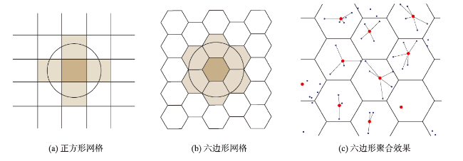
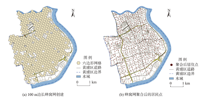
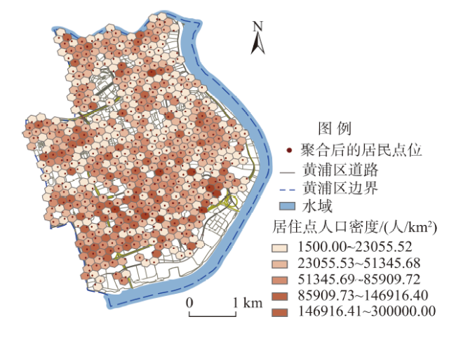
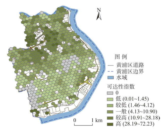
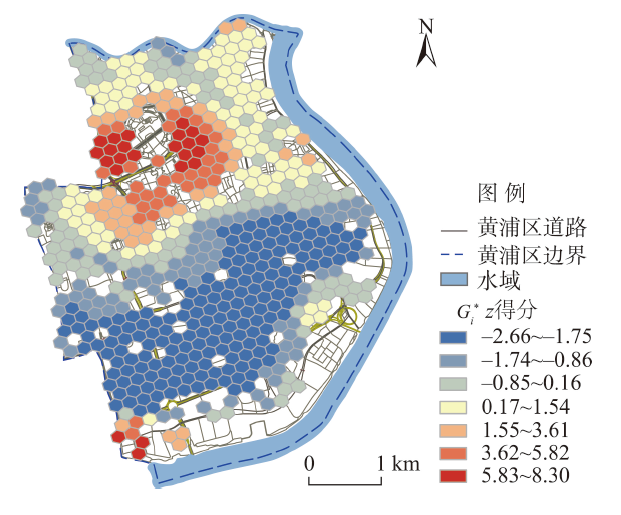
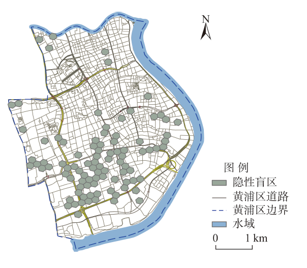
In order to solve the problem of unbalanced supply and demand of park green space in high density cities, this study used a Gaussian based two-step floating catchment area method to analyze the spatial accessibility of existing park green space in Huangpu District of Shanghai, under walking conditions. First, we extracted the point of interest (POI) data of residential areas from the Internet and aggregated them into a 100 m long hexagonal cellular network to calculate the number of people and population density, then through the Application Programming Interface (API) of Baidu Map we extracted the travel time between supply and demand points based on actual road conditions. Second, the paper took the park green space built by the end of 2018 in Huangpu District of Shanghai as an example, and considered the four aspects of residents' demand, accessibility classification, cold and hot spots, and blank areas. The results show that the accessibility level of park green space in Huangpu District is higher in the north and lower in the south, which is negatively correlated with the population density distribution. The dominant blind areas (9.16% of the total area) and the recessive blind areas (16.5% of the total area) should be eliminated. This study made a quantitative analysis on the supply and demand allocation, to provide guidance for the further optimization of green space layout and site selection. Finally, recommendations were made from three aspects of "increasing green space appropriately", "strengthening the quality of existing green space" and "community co-governance", in order to provide theoretical support for the Fourteenth Five-Year Plan of greening Huangpu District.
REN Jiayi , WANG Yun . Spatial accessibility of park green space in Huangpu District of Shanghai based on modified two-step floating catchment area method[J]. PROGRESS IN GEOGRAPHY, 2021 , 40(5) : 774 -783 . DOI: 10.18306/dlkxjz.2021.05.005
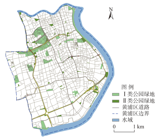
图2 2019年黄浦区公园绿地分布Fig.2 Distribution of park green space in Huangpu District, Shanghai, 2019 |
表1 黄浦区公园绿地基本信息示例Tab.1 Examples of some park green space in Huangpu District, Shanghai |
| 类别 | 面积范围/m2 | 公园绿地名称 | 地址 | 所在街道 | 面积/m2 |
|---|---|---|---|---|---|
| Ⅰ类 | 100000以上 | 人民公园 | 南京西路231号 | 南京东路街道 | 100000 |
| 广场公园(黄浦段) | 金陵西路50号 | 南京东路街道 | 159915 | ||
| 10000~100000 | 古城公园 | 人民路333号 | 豫园街道 | 38646 | |
| 南园公园 | 龙华东路800号 | 五里桥街道 | 73350 | ||
| 蓬莱公园 | 南车站路350号 | 半淞园路街道 | 35336 | ||
| Ⅱ类 | 2000~10000 | 九子公园 | 成都北路1018号 | 南京东路街道 | 7000 |
| 小桃园绿地 | 复兴东路河南南路 | 老西门街道 | 3700 | ||
| 绍兴公园 | 绍兴路62号 | 瑞金二路街道 | 2411 | ||
| 400~2000 | 淮茂绿地 | 淮海中路茂名南路 | 瑞金二路街道 | 1189 | |
| 东门广场 | 金坛路中华路 | 小东门街道 | 500 | ||
| 中山南路苗江路绿地 | 中山南路苗江路 | 半淞园路街道 | 904 |
图6 黄浦区公园绿地可达性空间分级结果Fig.6 Spatial classification results of accessibility of park green space in Huangpu District, Shanghai |
表2 黄浦区居住区公园绿地可达性水平分级统计Tab.2 Statistics of accessibility level of park green space in residential areas of Huangpu District, Shanghai |
| 可达性等级 | 聚合居住区 | 居住人口 | |||
|---|---|---|---|---|---|
| 数量/个 | 占比/% | 人口数/人 | 占比/% | ||
| 高(28.19~72.23) | 28 | 5.03 | 24754 | 3.75 | |
| 较高(10.91~28.18) | 97 | 17.41 | 95095 | 14.42 | |
| 一般(4.13~10.90) | 146 | 26.21 | 160827 | 24.39 | |
| 较低(1.46~4.12) | 118 | 21.19 | 132088 | 20.03 | |
| 低(0.01~1.45) | 117 | 21.00 | 176459 | 26.75 | |
| 0 | 51 | 9.16 | 70289 | 10.66 | |
| [1] |
俞孔坚, 段铁武, 李迪华, 等. 景观可达性作为衡量城市绿地系统功能指标的评价方法与案例[J]. 城市规划, 1999,23(8):8-11, 43.
[
|
| [2] |
|
| [3] |
|
| [4] |
|
| [5] |
|
| [6] |
|
| [7] |
尹海伟, 孔繁花, 宗跃光. 城市绿地可达性与公平性评价[J]. 生态学报, 2008,28(7):3375-3383.
[
|
| [8] |
|
| [9] |
宋正娜, 陈雯, 车前进, 等. 基于改进潜能模型的就医空间可达性度量和缺医地区判断: 以江苏省如东县为例[J]. 地理科学, 2010,30(2):213-219.
[
|
| [10] |
|
| [11] |
魏冶, 修春亮, 高瑞, 等. 基于高斯两步移动搜索法的沈阳市绿地可达性评价[J]. 地理科学进展, 2014,33(4):479-487.
[
|
| [12] |
陶卓霖, 程杨, 戴特奇. 北京市养老设施空间可达性评价[J]. 地理科学进展, 2014,33(5):616-624.
[
|
| [13] |
李孟桐, 杨令宾, 魏冶. 高斯两步移动搜索法的模型研究: 以上海市绿地可达性为例[J]. 地理科学进展, 2016,35(8):990-996.
[
|
| [14] |
徐彦秒, 曹娓, 何瑞珍. 结合建筑人口容量的南阳市公园可达性分析[J]. 浙江农业科学, 2015,56(4):492-496.
[
|
| [15] |
马林兵, 曹小曙. 基于GIS的城市公共绿地景观可达性评价方法[J]. 中山大学学报(自然科学版), 2006,45(6):111-115.
[
|
| [16] |
赵晓龙, 郑权一, 刘笑冰, 等. 基于2SFCA改进模型的城市公园绿地规划配置研究: 以深圳福田区为例[J]. 中国园林, 2018,34(S2):95-99.
[
|
| [17] |
卢宁, 李俊英, 闫红伟, 等. 城市公园绿地可达性分析: 以沈阳市铁西区为例[J]. 应用生态学报, 2014,25(10):2951-2958.
[
|
| [18] |
《黄浦年鉴》编纂委员会. 黄浦年鉴2018 [M]. 上海: 上海文化出版社, 2018.
[Huangpu District Yearbook Compilation Committee. Huangpu District Yearbook 2018. Shanghai, China: Shanghai Culture Press, 2018. ]
|
| [19] |
单卓然, 张衔春, 黄亚平. 武汉都市发展区及主城区城镇常住人口空间分布格局: 基于2010年第六次人口普查数据[J]. 人文地理, 2016,31(2):61-67.
[
|
| [20] |
|
| [21] |
王奇. 基于改进两步移动搜索法的上海市医疗服务可达性分析[D]. 武汉: 武汉大学, 2019.
[
|
| [22] |
|
| [23] |
|
| [24] |
|
| [25] |
|
| [26] |
|
| [27] |
|
| [28] |
陶卓霖, 程杨. 两步移动搜寻法及其扩展形式研究进展[J]. 地理科学进展, 2016,35(5):589-599.
[
|
| [29] |
|
| [30] |
|
| [31] |
赵兵, 李露露, 曹林. 基于GIS的城市公园绿地服务范围分析及布局优化研究: 以花桥国际商务城为例[J]. 中国园林, 2015,31(6):95-99.
[
|
/
| 〈 |
|
〉 |
