
Spatial characteristics and formation mechanism of coordinated development of urbanization in the Yangtze River Delta
Received date: 2020-06-28
Request revised date: 2020-08-25
Online published: 2021-03-28
Supported by
National Natural Science Foundation of China(41771171)
Soft Science Research Funded Project of Nanjing(202001014)
Copyright
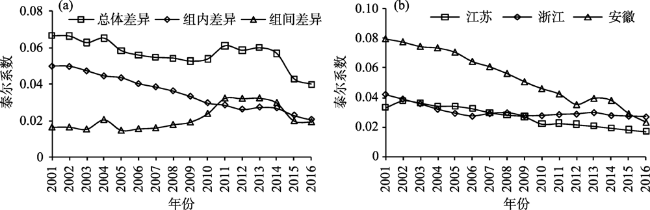
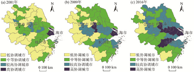
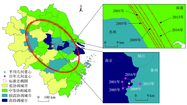
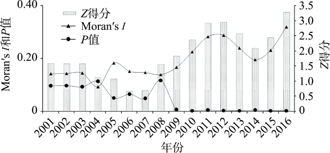
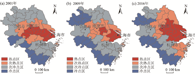
Based on the national strategy of Yangtze River Delta economic integration and regional coordinated development and after measuring the urbanization coordination level of 41 cities in the Yangtze River Delta from 2001 to 2016, this study analyzed the spatial characteristics and formation mechanism of the coordinated development of urbanization in the Yangtze River Delta by using the methods of Theil Index, center of gravity track, hotspot analysis, and spatial econometric model. The results show that: 1) the overall difference of urbanization coordination level in the Yangtze River Delta is fluctuating and decreasing, and intra-provincial differences are shrinking while the difference between the provinces is expanding; the spatial distribution of the coordination level of urbanization in the Yangtze River Delta is generally higher in the east and lower in the west. The pattern of coordinated development of urbanization has experienced little change in the northwest-southeast direction and the center of gravity is relatively stable over the years, but the spatial correlation scope and dispersion degree are expanding. 2) According to the characteristics of spatial agglomeration, there is a significant positive spatial autocorrelation in the coordination level of urbanization in the Yangtze River Delta. The hotspots are gradually converging to the economically developed areas such as Shanghai, Southern Jiangsu, and Northern Zhejiang. The cold spots are stably distributed in Northern Anhui, Southern Anhui, and southern Zhejiang. 3) All factors that affect the spatial characteristics of coordinated development of urbanization are significantly positive. The level of economic development still dominates coordinated regional development of urbanization. Population agglomeration is more obvious for the improvement of the level of coordinated development of urbanization of neighboring cities. Giving full play to the driving role of the highly coordinated area of urbanization will realize the balanced development of the Yangtze River Delta.
FAN Qingyu , YANG Shan . Spatial characteristics and formation mechanism of coordinated development of urbanization in the Yangtze River Delta[J]. PROGRESS IN GEOGRAPHY, 2021 , 40(1) : 124 -134 . DOI: 10.18306/dlkxjz.2021.01.012
表1 长三角地区城镇化协调水平重心参数Tab.1 Gravity parameters of urbanization coordination level in the Yangtze River Delta |
| 年份 | 重心坐标参数 | 标准差椭圆参数 | |||||
|---|---|---|---|---|---|---|---|
| 重心(经度, 纬度) | 方向 | 偏移/km | 转角/(°) | 主轴半径/km | 辅轴半径/km | ||
| 2001 | 119°06′43″E, 31°32′28″N | — | — | 141.357 | 277.469 | 166.897 | |
| 2005 | 119°07′00″E, 31°29′54″N | 东南 | 4.755 | 141.357 | 278.890 | 168.875 | |
| 2009 | 119°09′20″E, 31°30′32″N | 东北 | 3.919 | 142.809 | 278.599 | 169.160 | |
| 2013 | 119°13′50″E, 31°31′39″N | 东北 | 7.476 | 144.287 | 277.629 | 169.267 | |
| 2016 | 119°08′01″E, 31°33′47″N | 西北 | 10.110 | 142.648 | 278.774 | 168.932 | |
表2 城镇化协调水平与影响因子的Granger因果关系检验结果Tab.2 Granger causality test results of the coordination level of urbanization and influencing factors |
| 原假设 | F统计量 | 概率(P) | 结论 |
|---|---|---|---|
| Y不是Pgdp的Granger原因 | 0.064 | 0.938 | 接受原假设 |
| Pgdp不是Y的Granger原因 | 5.560 | 0.004 | 拒绝原假设*** |
| Y不是Tra的Granger原因 | 10.126 | <0.001 | 拒绝原假设*** |
| Tra不是Y的Granger原因 | 9.389 | <0.001 | 拒绝原假设*** |
| Y不是Pop的Granger原因 | 0.501 | 0.524 | 接受原假设 |
| Pop不是Y的Granger原因 | 6.358 | <0.001 | 拒绝原假设*** |
| Y不是Tec的Granger原因 | 25.366 | <0.001 | 拒绝原假设*** |
| Tec不是Y的Granger原因 | 0.566 | <0.001 | 拒绝原假设*** |
| Y不是Gov的Granger原因 | 1.587 | 0.164 | 接受原假设 |
| Gov不是Y的Granger原因 | 12.208 | <0.001 | 拒绝原假设*** |
注:***代表显著性在1%水平上拒绝原假设。 |
表3 空间计量模型检验结果Tab.3 Spatial measurement model test results |
| 检验方法 | 统计值 | 概率 | 检验方法 | 统计值 | 概率 |
|---|---|---|---|---|---|
| LM-spatial lag | 234.98 | <0.01 | Wald-spatial lag | 256.56 | <0.01 |
| Robust LM-spatial lag | 19.36 | <0.01 | LR-spatial lag | 246.23 | <0.01 |
| LM-spatial error | 276.38 | <0.01 | Wald-spatial error | 298.28 | <0.01 |
| Robust LM-spatial error | 75.16 | <0.01 | LR-spatial error | 401.29 | <0.01 |
表4 长三角地区协调水平演变的SDM回归结果Tab.4 SDM regression result of the change of coordination level in the Yangtze River Delta |
| 变量 | NF | TF | SF | STF | 变量 | NF | TF | SF | STF |
|---|---|---|---|---|---|---|---|---|---|
| Pgdp | 0.441* | 0.555* | 0.601** | 0.542** | W*Pgdp | 0.302** | 0.289* | 0.311** | 0.262** |
| Tra | 0.207* | 0.362* | 0.378** | 0.241** | W*Tra | 0.406* | 0.241** | 0.305* | 0.157* |
| Pop | 0.102** | 0.147* | 0.301* | 0.158 | W*Pop | 0.204* | 0.204* | 0.196 | 0.457 |
| Tec | 0.268* | 0.458** | 0.324** | 0.314* | W*Tec | 0.356* | 0.225** | 0.241** | 0.238* |
| Gov | 0.254* | 0.347** | 0.365*** | 0.401** | W*Gov | 0.044 | 0.124** | 0.187* | 0.224** |
| Adj.R2 | 0.854 | 0.768 | 0.898 | 0.505 | δ | 0.350 | 0.247** | 0.275** | 0.089* |
| Loglikelihood | -160.247 | -145.260 | -88.052 | -89.222 |
注:***、**和*分别代表回归参数在0.01、0.05和0.10水平上显著,下同;W*代表空间交互项。 |
表5 空间效应分解结果Tab.5 Spatial effect decomposition results |
| 空间效应 | Pgdp | Gov | Tra | Tec | Pop |
|---|---|---|---|---|---|
| 直接效应 | 0.302*** | 0.214*** | 0.207** | 0.202* | 0.127** |
| 间接效应 | 0.156*** | 0.131* | 0.123* | 0.112* | 0.152* |
| 总效应 | 0.458*** | 0.345* | 0.330** | 0.314* | 0.279* |
| [1] |
中共中央国务院. 长江三角洲区域一体化发展规划纲要 [EB/OL]. 2019-12-01 [2020-08-25]. http://www.xinhuanet.com/politics/2019-12/01/c_1125295202.htm.
[ CPC Central Committee. Outline of the Yangtze River Delta regional integration development plan. 2019-12-01 [2020-08-25]. http://www.xinhuanet.com/politics/2019-12/01/c_1125295202.htm.]
|
| [2] |
|
| [3] |
|
| [4] |
|
| [5] |
|
| [6] |
|
| [7] |
|
| [8] |
|
| [9] |
|
| [10] |
|
| [11] |
|
| [12] |
|
| [13] |
|
| [14] |
陈明星. 城市化领域的研究进展和科学问题[J]. 地理研究, 2015,34(4):614-630.
[
|
| [15] |
陈明星, 叶超, 陆大道, 等. 中国特色新型城镇化理论内涵的认知与建构[J]. 地理学报, 2019,74(4):633-647.
[
|
| [16] |
陆大道, 姚士谋. 中国城镇化进程的科学思辨[J]. 人文地理, 2007,22(4):1-5, 26.
[
|
| [17] |
方创琳, 王德利. 中国城市化发展质量的综合测度与提升路径[J]. 地理研究, 2011,30(11):1931-1946.
[
|
| [18] |
李小建, 罗庆. 新型城镇化中的协调思想分析[J]. 中国人口∙资源与环境, 2014,24(2):47-53.
[
|
| [19] |
王云, 马丽, 刘毅. 城镇化研究进展与趋势: 基于CiteSpace和HistCite的图谱量化分析[J]. 地理科学进展, 2018,37(2):239-254.
[
|
| [20] |
边雪, 陈昊宇, 曹广忠. 基于人口、产业和用地结构关系的城镇化模式类型及演进特征: 以长三角地区为例[J]. 地理研究, 2013,32(12):2281-2291.
[
|
| [21] |
曹广忠, 边雪, 刘涛. 基于人口、产业和用地结构的城镇化水平评估与解释: 以长三角地区为例[J]. 地理研究, 2011,30(12):2139-2149.
[
|
| [22] |
孙东琪, 张京祥, 张明斗, 等. 长江三角洲城市化效率与经济发展水平的耦合关系[J]. 地理科学进展, 2013,32(7):1060-1071.
[
|
| [23] |
周艳, 黄贤金, 徐国良, 等. 长三角城市土地扩张与人口增长耦合态势及其驱动机制[J]. 地理研究, 2016,35(2):313-324.
[
|
| [24] |
王锋, 张芳, 林翔燕, 等. 长三角“人口—土地—经济—社会”城镇化的耦合协调性研究[J]. 工业技术经济, 2018,37(4):45-52.
[
|
| [25] |
|
| [26] |
范擎宇, 杨山, 胡信. 耦合视角下长三角地区城镇化协调度的时空特征及交互机制[J]. 地理研究, 2020,39(2):289-302.
[
|
| [27] |
|
| [28] |
樊杰, 陶岸君, 吕晨. 中国经济与人口重心的耦合态势及其对区域发展的影响[J]. 地理科学进展, 2010,29(1):87-95.
[
|
| [29] |
|
| [30] |
|
| [31] |
|
| [32] |
陈明星, 陆大道, 张华. 中国城市化水平的综合测度及其动力因子分析[J]. 地理学报, 2009,64(4):387-398.
[
|
| [33] |
曹文莉, 张小林, 潘义勇, 等. 发达地区人口、土地与经济城镇化协调发展度研究[J]. 中国人口·资源与环境, 2012,22(2):141-146.
[
|
| [34] |
|
| [35] |
朱江丽, 李子联. 长三角城市群产业—人口—空间耦合协调发展研究[J]. 中国人口·资源与环境, 2015,25(2):75-82.
[
|
| [36] |
张宇, 曹卫东, 梁双波, 等. 长江经济带城镇化协同演化时空格局研究[J]. 长江流域资源与环境, 2016,25(5):715-724.
[
|
| [37] |
范擎宇, 杨山. 协调视角下长三角城市群的空间结构演变与优化[J]. 自然资源学报, 2019,34(8):1581-1592.
[
|
| [38] |
欧向军, 甄峰, 秦永东, 等. 区域城市化水平综合测度及其理想动力分析: 以江苏省为例[J]. 地理研究, 2008,27(5):993-1002.
[
|
| [39] |
王亚华, 袁源, 王映力, 等. 人口城市化与土地城市化耦合发展关系及其机制研究: 以江苏省为例[J]. 地理研究, 2017,36(1):149-160.
[
|
| [40] |
吴一凡, 刘彦随, 李裕瑞. 中国人口与土地城镇化时空耦合特征及驱动机制[J]. 地理学报, 2018,73(10):1865-1879.
[
|
| [41] |
刘帅宾, 杨山, 王钊. 基于人口流的中国省域城镇化空间关联特征及形成机制[J]. 地理学报, 2019,74(4):648-663.
[
|
/
| 〈 |
|
〉 |