
Impact of urban development on the risk of flooding: A case study of Wuhan City, China
Received date: 2019-12-12
Request revised date: 2020-05-02
Online published: 2021-01-28
Supported by
National Social Science Founding of China(18BGL270)
Copyright
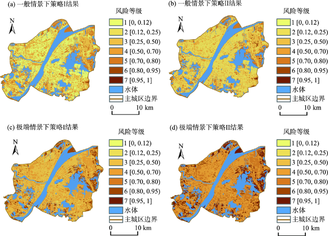
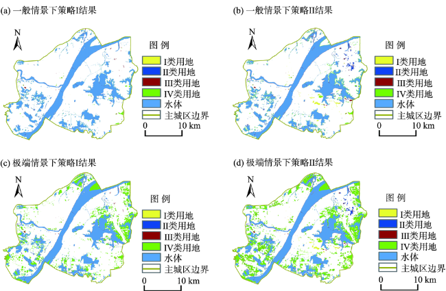
Urban pluvial flooding is an increasing problem for cities worldwide. Urban spatial growth and development have been widely recognized as one of the most important contributors to the increasing risk of flood disasters. Using Wuhan City, China as a case, this study developed a binary Logistic model to quantify the impacts of urban development on flooding under different rainfall scenarios (regular and extreme), especially the role of land conversion from water areas. Based on historical remote sensing data, the analysis of the dynamic land use changes indicates that over 30% of water areas had been converted into urban construction lands from 1984 to 2017. The results show that the conversion of water areas severely intensified the flooding risk of the surrounding locations in the extreme rainfall scenario. In addition to this land conversion, elevation, drainage conditions, land use types, and land use of surrounding areas are also significantly correlated with urban flooding. Based on two land use and development strategies, the risk maps of future flooding were predicted under regular and extreme rainfall scenarios. These maps show that the development of the remaining vacant lands will induce even worse flooding. Adaptation strategies corresponding to different land use types are provided according to the predicted flooding risks. The model could help develop adaptation strategies and policies to cope with future urban flooding by exploring its driving factors.
ZHAO Liyuan , WEI Jialing . Impact of urban development on the risk of flooding: A case study of Wuhan City, China[J]. PROGRESS IN GEOGRAPHY, 2020 , 39(11) : 1898 -1908 . DOI: 10.18306/dlkxjz.2020.11.010
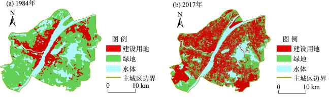
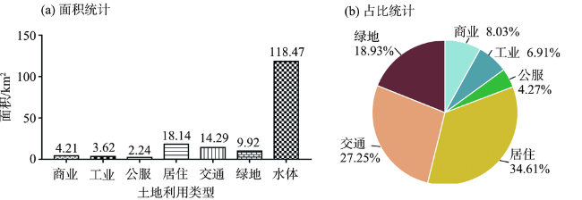
表1 武汉市主城区1984—2017年土地利用变化Tab.1 Land use changes in Wuhan City, 1984-2017 |
| 年份 | 建设用地/km2 | 绿地/km2 | 水体/km2 |
|---|---|---|---|
| 1984 | 122.84 | 397.05 | 170.90 |
| 2017 | 364.09 | 208.23 | 118.47 |
| 变化* | +241.25 | -188.82 | -52.42 |
注:*表示以1984年为基准年,2017年用地变化情况,增加用“+”表示,减少用“-”表示。 |
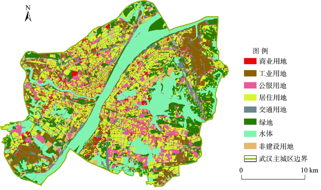
表2 城市建设因素指标体系Tab.2 Indicators of urban development and their descriptive statistics |
| 因素分类 | 解释变量 | 数据统计分析 | 数据量解释 | ||
|---|---|---|---|---|---|
| 取值范围 | 平均值 | 标准差 | |||
| 地形地势因素 | 高程 () | [-5, 101] | 27.338 | 7.899 | 栅格实际高程数值 |
| 邻域内海拔最低 () | [0, 1] | 0.103 | 0.305 | 若Moore邻域内该栅格海拔最低,值为1; 若Moore邻域内该栅格海拔非最低,值为0 | |
| 排水管网条件 | 距排水管网距离 () | [1, 3] | 1.944 | 0.830 | 0≤距离≤30 m,值为3; 30 m<距离≤100 m,值为2; 100 m<距离,值为1 |
| 地表不透水性 | 各类用地不透水率 () | [0, 3] | 0.622 | 1.066 | 道路不透水率,值为3; 建设用地不透水率,值为2; 绿地不透水率,值为1; 水域不透水率,值为0 |
| 土地利用类型 | 栅格用地类型为绿地 | [0, 1] | 0.171 | 0.377 | 栅格为绿地类型,值为1; 栅格不是绿地类型,值为0 |
| 邻域绿地栅格数 | [1, 8] | 1.360 | 2.704 | Moore邻域中绿地栅格的个数:值为1至8的整数 | |
| 邻域水体栅格数 | [1, 8] | 0.721 | 2.106 | Moore邻域中水栅格的个数:值为1至8的整数 | |
| 填湖造陆因素 | 1984—2017年间被填占的水域栅格 | [0, 2] | 0.033 | 0.178 | 未填湖非水域的栅格,值为0; 水域转绿地的栅格,值为1; 水域转城市建设用地的栅格,值为2 |
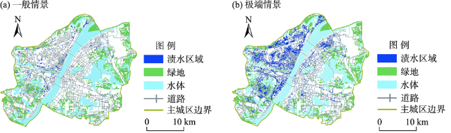
表3 2种降雨情景下二项Logistic回归结果Tab.3 Logistic regression results for two rainfall scenarios |
| 解释变量 | 一般情景 (24 h~95 mm) | 极端情景 (24 h~249 mm) | ||||||
|---|---|---|---|---|---|---|---|---|
| 回归系数 | t统计量 | P值 | 回归系数 | t统计量 | P值 | |||
| 地形地势因素 | 高程 | -0.521 | -2.616 | *** | 1.990 | 22.944 | *** | |
| 邻域内海拔最低 | 0.188 | 3.924 | *** | 0.086 | 4.500 | *** | ||
| 排水管网条件 | 距排水管网距离 | -1.378 | -25.268 | *** | -1.385 | -61.811 | *** | |
| 地表不透水性 | 各类用地不透水性 | 3.112 | 11.299 | *** | 1.380 | 14.697 | *** | |
| 土地利用类型 | 栅格用地类型为绿地 | -2.224 | -10.984 | *** | -1.104 | -15.798 | *** | |
| 邻域绿地栅格 | 2.076 | 8.602 | *** | 3.866 | 41.569 | *** | ||
| 邻域水体栅格数 | 1.865 | 14.908 | *** | 1.233 | 26.057 | *** | ||
| 填湖造陆因素 | 1984—2017年间被填占的水域栅格 | -0.202 | -2.601 | *** | 0.116 | 5.902 | *** | |
| 常数项 | 0.683 | 8.177 | *** | 0.212 | 6.184 | *** | ||
注:***表示显著性水平为1%。 |
| [1] |
|
| [2] |
|
| [3] |
|
| [4] |
|
| [5] |
|
| [6] |
|
| [7] |
|
| [8] |
|
| [9] |
|
| [10] |
|
| [11] |
|
| [12] |
|
| [13] |
吴健生, 张朴华. 城市景观格局对城市内涝的影响研究: 以深圳市为例[J]. 地理学报, 2017,72(3):444-456.
[
|
| [14] |
彭建, 魏海, 武文欢, 等. 基于土地利用变化情景的城市暴雨洪涝灾害风险评估: 以深圳市茅洲河流域为例[J]. 生态学报, 2018,38(11):3741-3755.
[
|
| [15] |
王玉鑫, 曾燕, 邱新法, 等. 土地利用变化对城市积涝的影响研究: 以南京市浦口区为例[J]. 气象科学, 2017,37(2):231-238.
[
|
| [16] |
|
| [17] |
|
| [18] |
|
| [19] |
|
| [20] |
|
| [21] |
|
| [22] |
|
| [23] |
|
| [24] |
|
| [25] |
|
| [26] |
|
| [27] |
李仁东. 土地利用变化对洪水调蓄能力的影响: 以洞庭湖区为例[J]. 地理科学进展, 2010,23(6):90-95, 115-116.
[
|
| [28] |
曾忠平, 彭浩轩. 城市湿地损失和内涝灾害响应的遥感分析: 以武汉市南湖为例[J]. 长江流域资源与环境, 2018,27(4):929-938.
[
|
| [29] |
|
| [30] |
|
| [31] |
|
| [32] |
|
| [33] |
|
| [34] |
|
| [35] |
|
| [36] |
|
| [37] |
|
/
| 〈 |
|
〉 |