
Spatio-temporal characteristics of famine and its environmental causes in the Jiangsu-Shanghai region during the Qing Dynasty (1644-1911)
Received date: 2019-08-05
Request revised date: 2019-10-10
Online published: 2020-10-28
Supported by
National Natural Science Foundation of China(41701219)
Project of Philosophy and Social Science Research in Colleges and Universities in Jiangsu Province(2017SJB0161)
National Key Research and Development Project(2016YFA0600401)
Open Project for Institute of History of Science and Technology in Nanjing University of Information Science & Technology(1061151801138)
Copyright
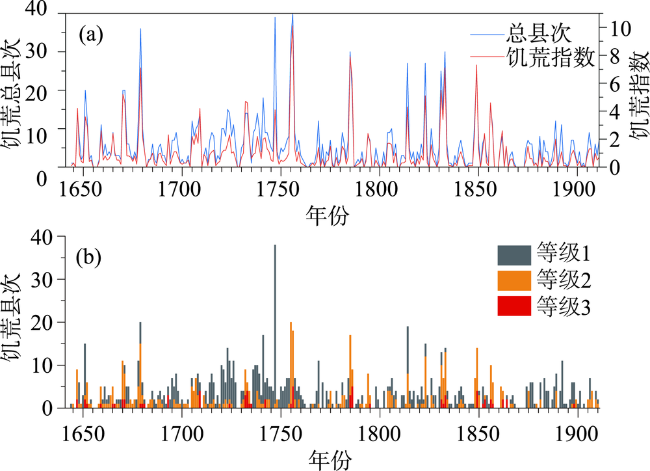
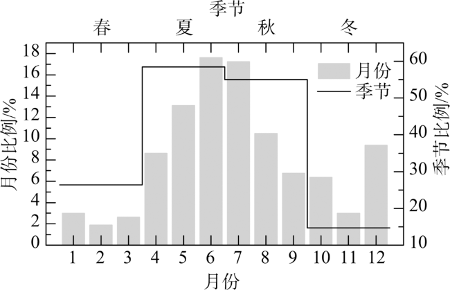
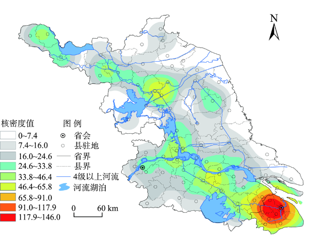
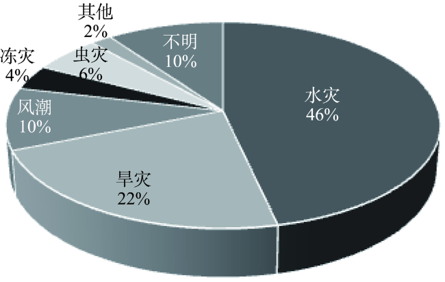
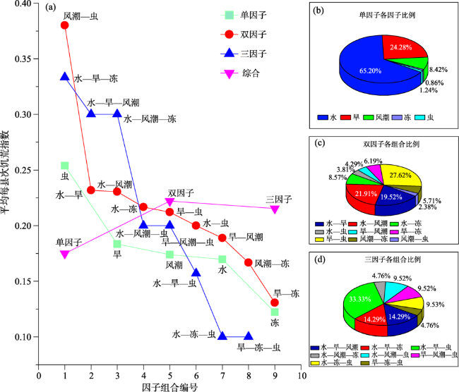
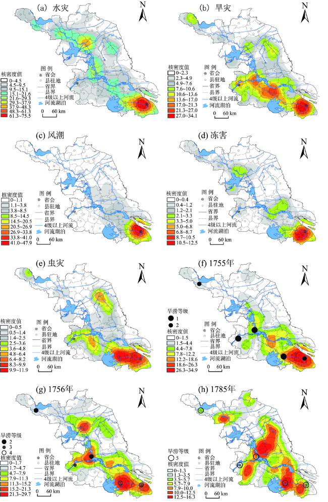
The risk of famine and food insecurity in the process of socioeconomic development is an important issue. This study examined the trend of famines in the Jiangsu and Shanghai region in the Qing Dynasty during 1644-1911. Based on the 1487 famine records extracted from local chronicles and other historical materials, this study first reconstructed two annual sequences of famines (frequency of counties affected by famine and its weighted index) by using the semantic differential method and weighted index. Then, the study quantitatively explored the spatial-temporal variations of the famines and their causes from different factors and their combinations during the Qing Dynasty, using multiple statistical tools such as wavelet analysis and kernel density estimation. The results show that: 1) Famines were very frequent in the Jiangsu and Shanghai area throughout the Qing Dynasty, with an average of one famine per 1.2 years and six counties affected annually by famines, but the vast majority of famine years were dominated by mild famines (grade 1) and moderate famines (grade 2). The frequency and intensity of the famines in the study area displayed clear patterns of phasic, periodic, seasonal, and intermittent explosive changes. The most serious periods were the mid-late part of the prosperous Kangxi-Qianlong times, and the periods during the reigns of Daoguang and Xianfeng when the Qing Dynasty turned from prosperity to decline. In addition to the increasing frequency of extreme droughts and floods in these two periods, it might also be related to the significant increase in the exposure and vulnerability of the social system to disasters and famines at those times. 2) The spatial distribution of famines is characterized by a pattern of "two-zones and multi-nucleus" from southeast to northwest. The areas along the banks of the Yangtze River, around the Taihu Lake and the Gaoyou Lake, the old Yellow River course and the Hongze Lake were famine-prone areas. Besides the social factors like population and economic development, the geographic environment, especially the distribution of water bodies, had an important impact on the distribution of famine-prone areas. 3) The main environmental factors that caused famine were flooding, followed by droughts and storm surges, and other disasters accounted for only a small part. The combination of different disaster-causing factors would have different effects on famine. The proportion of famines caused by a single environmental factor accounted for the vast majority. With regard to the severity of famine, the mean famine index values corresponding to those caused by a combination of two and three environmental factors were both larger than that of a single factor. The distribution of famines related to floods and droughts determined the overall distribution pattern of famines in the Jiangsu-Shanghai region during 1644-1911. The above understanding can provide some valuable reference for identifying high-risk areas of famine in Jiangsu and Shanghai and exploring the impact of regional natural hazards on famine and protection mechanisms of food security in the future.
WEI Zhudeng . Spatio-temporal characteristics of famine and its environmental causes in the Jiangsu-Shanghai region during the Qing Dynasty (1644-1911)[J]. PROGRESS IN GEOGRAPHY, 2020 , 39(8) : 1333 -1344 . DOI: 10.18306/dlkxjz.2020.08.008
表1 饥荒记录的分级标准Tab.1 Grading criteria for famine records |
| 饥荒等级 | 饥荒程度描述关键词 | 意义 |
|---|---|---|
| 1 | 饥,荒,祲,民艰于食,民乏食(食豆饼糟糠),路有流民(零星),赈济(钱粮)等 | 轻度饥荒:粮食严重短缺;通过缩衣节食或接受救济尚可维持;零星人口流移 |
| 2 | 大饥,大荒(奇荒,大祲),人食草根树皮、观音土,民不聊生,饥民众多,流亡(乞食)载道,道殣相望,卖儿鬻女,聚众抢夺(成群横索),间有死者 | 中度饥荒:粮食极为短缺;依靠替代性食物、大范围流亡迁徙等现象更为普遍;小范围人口死亡和社会秩序趋于混乱 |
| 3 | 人相食,饥死、饿死者无算(死者甚众),死者枕藉,死者载道,亘古奇荒,死者数万(有具体数字) | 重度饥荒:粮食极端短缺;人口大量死亡;道德伦理和社会秩序崩溃 |
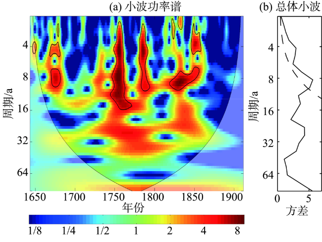
图1 清代(1644—1911年)苏沪地区的饥荒序列Fig.1 The famine sequence in the Jiangsu and Shanghai region during the Qing Dynasty, 1644-1911 |
表2 清代苏沪地区饥荒的阶段性特征Tab.2 Temporal characteristics of famines in the Jiangsu and Shanghai region in the Qing Dynasty |
| 编号 | 时段 | 跨越 年数/a | 饥荒年数/平均时间间隔 | 饥荒县次/年均饥荒县次 | 饥荒指数 /年均饥荒县次 | 饥荒 特点 | ||||||
|---|---|---|---|---|---|---|---|---|---|---|---|---|
| 等级1 | 等级2 | 等级3 | 总年数 | 等级1 | 等级2 | 等级3 | 总县次 | |||||
| 0 | 1644—1911年 | 268 | 208/1.29 | 134/2.00 | 35/7.66 | 221/1.21 | 973/3.63 | 444/1.66 | 70/0.26 | 1487/5.55 | 272.5/1.02 | — |
| 1 | 1644—1683年 | 40 | 33/1.21 | 31/1.29 | 11/3.64 | 35/1.14 | 138/3.45 | 95/2.38 | 15/0.38 | 248/6.20 | 51.3/1.28 | 多发—偏重 |
| 2 | 1684—1719年 | 36 | 29/1.24 | 23/1.57 | 2/18.00 | 34/1.06 | 113/3.14 | 49/1.36 | 7/0.19 | 169/4.69 | 30.2/0.84 | 多发—偏轻 |
| 3 | 1720—1760年 | 41 | 38/1.08 | 24/1.71 | 8/5.13 | 39/1.05 | 292/7.12 | 88/2.15 | 18/0.44 | 398/9.70 | 66.4/1.62 | 多发—偏重 |
| 4 | 1761—1813年 | 53 | 36/1.47 | 20/2.65 | 3/17.67 | 39/1.36 | 128/2.42 | 69/1.30 | 9/0.17 | 206/3.89 | 38.9/0.73 | 少发—偏轻 |
| 5 | 1814—1857年 | 44 | 38/1.16 | 21/2.10 | 8/5.50 | 38/1.16 | 173/3.93 | 107/2.43 | 16/0.36 | 296/6.73 | 59.0/1.34 | 多发—偏重 |
| 6 | 1858—1911年 | 54 | 34/1.59 | 15/3.60 | 3/18.00 | 36/1.50 | 129/2.39 | 36/0.67 | 5/0.09 | 170/3.15 | 26.7/0.49 | 少发—偏轻 |
注:“/”后的数据为平均时间间隔(a)或年均饥荒县次(次)。 |
表3 各阶段的饥荒频发期Tab.3 Periods of frequent famines in each stage |
| 阶段 | 频发期 |
|---|---|
| 1644—1683年 | 1670—1673、1678—1680年 |
| 1684—1719年 | 1695—1697、1705—1709、1714—1716年 |
| 1720—1760年 | 1720—1727、1731—1734、1736—1739、 1741—1744、1753—1757年 |
| 1761—1813年 | 1784—1786、1804—1806年 |
| 1814—1857年 | 1831—1834、1848—1850年 |
| 1858—1911年 | 1875—1877年 |
| [1] |
FAO/FSAU. Integrated food security and humanitarian phase classification [R]. FAO/FSAU Technical Series IV: Technical Manual Version 1. Nairobi, Kenya, 2006.
|
| [2] |
FAO, IFAD, UNICEF, et al. The state of food security and nutrition in the world 2017. Building resilience for peace and food security [R]. Rome, Italy: FAO, 2017.
|
| [3] |
邓云特. 中国救荒史 [M]. 北京: 北京出版社, 1998.
[
|
| [4] |
李文海, 林敦奎, 周源, 等. 近代中国灾荒纪年 [M]. 长沙: 湖南教育出版社, 1990.
[
|
| [5] |
夏明方. 民国时期自然灾害与乡村社会[M]. 北京: 中华书局, 2000.
[
|
| [6] |
张水良. 中国灾荒史(1927—1937年) [M]. 厦门: 厦门大学出版社, 1990.
[
|
| [7] |
孟昭华. 中国灾荒史记 [M]. 北京: 中国社会出版社, 1999.
[
|
| [8] |
仇立慧, 黄春长. 古代黄河中游饥荒与环境变化关系及其影响[J]. 干旱区研究, 2008,25(1):145-150.
[
|
| [9] |
陈明. 元代北方饥荒的时空分布特点及救荒措施[J]. 古今农业, 2001(4):23-33.
[
|
| [10] |
袁林. 甘宁青历史饥荒统计规律研究[J]. 兰州大学学报(社会科学版), 1996(4):69-75.
[
|
| [11] |
袁林. 陕西历史饥荒统计规律研究[J]. 陕西师范大学学报(哲学社会科学版), 2002,31(5):12-17.
[
|
| [12] |
滕静超, 苏筠, 方修琦. 中国西汉—清代饥荒序列的重建及特征分析[J]. 中国历史地理论丛, 2014,29(4):26-32.
[
|
| [13] |
郑斯中. 1400—1949年广东省的气候振动及其对粮食丰歉的影响[J]. 地理学报, 1983,50(1):25-32.
[
|
| [14] |
郑景云, 赵会霞. 清代中后期江苏四季降水变化与极端降水异常事件[J]. 地理研究, 2005,24(5):673-680.
[
|
| [15] |
张德二. 中国三千年气象记录总集 [M]. 南京: 江苏教育出版社, 2004.
[
|
| [16] |
温克刚. 中国气象灾害大典 [M]. 北京: 中国气象出版社, 2008.
[
|
| [17] |
火恩杰, 刘昌森. 上海地区自然灾害史料汇编(公元751—1949年) [M]. 北京: 地震出版社, 2002.
[
|
| [18] |
江苏省地方志编纂委员会办公室. 江苏省通志稿(灾异志) [M]. 南京: 江苏古籍出版社, 2000.
[ Office of Jiangsu Local Chronicle Compilation Committee. General chronicle of Jiangsu Province (disaster chronicles). Nanjing, China: Jiangsu Ancient Books Publishing House, 2000. ]
|
| [19] |
方修琦, 苏筠, 尹君, 等. 历史气候变化影响研究中的社会经济等级序列重建方法探讨[J]. 第四纪研究, 2014,34(6):1204-1214.
[
|
| [20] |
魏柱灯, 方修琦, 苏筠. 气候变化对中国古代财政平衡的影响[J]. 地理科学, 2015,35(9):1156-1163.
[
|
| [21] |
牛汉平. 清代政区沿革综表 [M]. 北京: 中国地图出版社, 1990.
[
|
| [22] |
谭其骧. 中国历史地图集(第8册) [M]. 北京: 中国地图出版社, 1982.
[
|
| [23] |
萧凌波. 1736—1911年中国水灾多发区分布及空间迁移特征[J]. 地理科学进展, 2018,37(4):495-503.
[
|
| [24] |
赵筱侠. 黄河夺淮对苏北水环境的影响[J]. 南京林业大学学报(人文社会科学版), 2013(3):92-101.
[
|
| [25] |
曹树基. 太平天国战争对苏南人口的影响[J]. 历史研究, 1998(2):64-74.
[
|
| [26] |
王树槐. 中国现代化的区域研究: 江苏省(1860—1916)[M]. 中央研究院近代史研究所, 1984.
[
|
| [27] |
王绍武, 王国学, 张作梅, 等. 公元 1380—1989 年长江黄河流域的旱涝变化 [C]// 王绍武, 黄朝迎. 长江黄河旱涝灾害发生规律及其经济影响的诊断研究. 北京: 气象出版社, 1993.
[
|
| [28] |
李禧亮, 毕硕本, 魏军, 等. 清代江苏省干湿时空特征分析[J]. 地理与地理信息科学, 2014,30(1):101-104.
[
|
| [29] |
陈家其. 太湖流域南宋以来旱涝规律及其成因初探[J]. 地理科学, 1989,9(1):25-33.
[
|
| [30] |
徐新创, 葛全胜, 郑景云, 等. 湖北省近500年区域干湿序列重建及其比较分析[J]. 地理研究, 2010,29(6):1045-1055.
[
|
| [31] |
|
| [32] |
李志, 王健, 刘文兆. 泾河流域气候变化及其与ENSO的关系[J]. 地理科学进展, 2010,29(7):833-839.
[
|
| [33] |
李伏明. 论明清时期松江府的农业发展及其地位: 以粮食生产和供应为中心的考察[J]. 中国农史, 2006(3):22-30.
[
|
| [34] |
崔玉娟, 张玉洁, 方修琦, 等. 1644—1949年长江三角洲地区五种洪涝致灾因子组合特征分析[J]. 长江流域资源与环境, 2015,24(4):697-704.
[
|
| [35] |
|
| [36] |
张德二. 1755年中国东部极端雨涝事件研究[J]. 气候变化研究进展, 2012,8(1):1-7.
[
|
| [37] |
孙宝兵. 明清时期江苏沿海地区的风暴潮灾与社会反应[D]. 桂林: 广西师范大学, 2007.
[
|
| [38] |
李钢, 刘倩, 王会娟, 等. 江苏千年蝗灾的时空特征与环境响应[J]. 自然灾害学报, 2015,24(5):184-198.
[
|
| [39] |
中央气象局气象科学研究所. 中国近五百年旱涝分布图集 [M]. 北京: 地图出版社, 1981.
[ Chinese Academy of Meteorological Science, China Meteorological Administration. Yearly charts of dryness/wetness in China for the last 500-year period. Beijing, China: Sino Maps Press, 1981. ]
|
| [40] |
张德二. 相对温暖气候背景下的历史旱灾: 1784—1787年典型灾例[J]. 地理学报, 2000,55(S1):106-112.
[
|
/
| 〈 |
|
〉 |