
Integrated physical regionalization of stony deserts in China
Online published: 2016-01-31
Supported by
Forestry NonprofitSpecific Project, No.201404304;Surveying and Mapping Geoinformation Nonprofit Specific Project, No.201512033
Copyright
Stony deserts are widely distributed in the arid and extremely arid regions in China. However, an integrated physical regionalization of these stony deserts has not been carried out. Based on a comprehensive analysis of the relationship between the characteristics and formation mechanism of stony deserts, the main features of stony deserts can be summarized as follows: land surface is covered with gravels; surface layer has porous thin desert crust, below which red brown compact and gypsum layers are found. Vegetation mainly includes arid and extremely arid shrubs and semi-shrubs with low coverage. Stony deserts only exist in arid and extremely arid regions with aridity index greater than 4. Based on the regional differentiation of characteristics and formation conditions of stony deserts, this study selected indicators reflecting aridity and temperature, regional geology and geomorphology, and formation conditions and types of surface materials to classify the stony deserts into three first-level regions (temperate arid and extremely arid region, warm temperate arid and extremely arid region, and arid and extremely arid region in northern Tibetan Plateau); nine second-level regions (according to regional geological and topographical features), and 19 third-level regions (based on regional formation conditions and types of surface materials). Further division can be made based on regional differentiation of soils and vegetation.
SHEN Yuancun , WANG Xiuhong , CHENG Weiming , WU Jinfeng , LU Qi , FENG Yiming . Integrated physical regionalization of stony deserts in China[J]. PROGRESS IN GEOGRAPHY, 2016 , 35(1) : 57 -66 . DOI: 10.18306/dlkxjz.2016.01.007
Tab.1 Temperature zone and aridity-humidity conditions in the stony desert regions in China表1 戈壁分布区域温度带与干湿状况划分指标 |
| 温度带 | 主要指标 | 干湿状况 | 干燥度K值 | |
|---|---|---|---|---|
| ≥10oC积温日数/d | ≥10oC积温数值/oC | |||
| 寒温带 中温带 暖温带 高原温带 高原亚寒带 | <100 100~170 170~220 50~180 <50 | <1600 1600~3200(3400) 3200(3400)~4500(4800) 1600~3200 <1100 | 湿润环境 半湿润环境 半干旱 干旱 极干旱* | <1.00 1.00~1.50 1.50~4.00 >4.00 >8.00 |
*极干旱,戈壁內部分异确立的指标。 |
Tab.2 Geomorphologic units and basic geomorphologic forms in the stony desert regions in China表2 中国戈壁分布区大地貌单元与地貌基本形态分区 |
| 大地貌单元 | 区域地貌基本形态区 |
|---|---|
| 1.内蒙古高原 | 1.1内蒙古高原西部高原 |
| 2.鄂尔多斯高原 | 2.1鄂尔多斯西部贺兰山东麓山前平原 |
| 3.阿拉善高原 | 3.1乌兰布和高地 3.2腾格里高地 3.3巴丹吉林高地 3.4雅玛雷克高原 3.5居延盆地台地 |
| 4.河西走廊凹陷平原 | 4.1石羊河流域中下游平原 4.2黑河流域中下游平原 4.3疏勒河流域中下游平原 |
| 5.北疆凹陷平原 | 5.1古尔班通古特(准噶尔)盆地 5.2乌苏—精河盆地 5.3布尔津—哈巴河—吉木乃盆地 |
| 6.南疆凹陷平原与吐哈盆地 | 6.1塔里木河冲积平原(塔克拉玛干盆地) 6.2托克拉克—布古里高地 6.3库鲁克—克孜勒苏高地 6.4吐哈盆地 |
| 7.青藏高原北部凹陷平原与山原区 | 7.1柴达木盆地 7.2昆仑山高山与羌塘高原 |
Tab.3 Formation types of gravel covers表3 砾质覆盖体的成因类型 |
| 主导成因 | 侵蚀/堆积类型与砾型 |
|---|---|
| 1.高原风蚀剥蚀残积堆积型(高原残积堆积型) | 1.1剥蚀残积粗砾质堆积 1.2剥蚀残积—坡积砾石、粗砾质堆积 1.3 剥蚀残积—坡积—洪积砾质堆积 1.4剥蚀残积—洪积砂砾质堆积 |
| 2.山麓山洪侵蚀堆积型(山麓侵蚀堆积型) | 2.1坡积—洪积砾石、粗砾质堆积 2.2洪积粗砾质堆积 2.3洪积—冲积砂砾质堆积 |
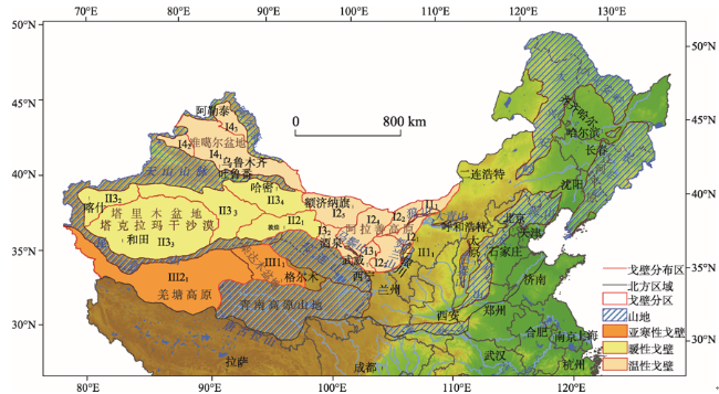
Fig.1 Division of stony deserts and distribution of mountainous areas in northern China图1 中国北部区域戈壁分区与山地分布图 |
Tab.4 Regionalization of stony deserts in China表4 中国戈壁分区系统 |
| 第一级(区) | 第二级(地区) | 第三级(亚地区) |
|---|---|---|
| Ⅰ. 温性干旱极干旱戈壁区 | Ⅰ1内蒙古高原西部干旱戈壁地区 | Ⅰ11二连浩特—苏尼特右旗剥蚀残积砾质戈壁亚地区 |
| Ⅰ2阿拉善高原干旱极干旱戈壁地区 | Ⅰ21乌兰布和高地残积—洪积砾质戈壁亚地区 Ⅰ22雅玛雷克高原残积—洪积砂砾质戈壁亚地区 Ⅰ23腾格里高地残积—洪积砂砾质戈壁亚地区 Ⅰ24巴丹吉林高地残积粗砾质戈壁亚地区 Ⅰ25居延盆地台地剥蚀—洪积砾质戈壁亚地区 | |
| Ⅰ3河西走廊东中部干旱极干旱戈壁地区 | Ⅰ31石羊河流域中下游平原洪积冲积砂砾质戈壁亚地区 Ⅰ32黑河流域中下游平原洪积粗砾质戈壁亚地区 | |
| Ⅰ4北疆盆地干旱极干旱戈壁地区 | Ⅰ41准噶尔盆地东部剥蚀—洪积砾质戈壁亚地区 Ⅰ42乌苏—精河盆地山前洪积—冲积砂砾质戈壁亚地区 Ⅰ43布尔津—哈巴河—吉木乃盆地洪积—冲积砂砾质戈壁亚地区 | |
| Ⅱ. 暖性干旱极干旱戈壁区 | Ⅱ1鄂尔多斯高原西部干旱戈壁地区 | Ⅱ11 贺兰山东麓冲积——洪积砂砾质戈壁亚地区 |
| Ⅱ2 河西走廊西部极干旱戈壁地区 | Ⅱ21敦煌—库姆塔格残积—洪积砾质砂砾质戈壁亚地区 | |
| Ⅱ3南疆盆地极干旱戈壁地区 | Ⅱ31塔克拉码干盆地洪积坡积砾质砂砾质戈壁亚地区 Ⅱ32喀什山前平原洪积坡积砾质戈壁亚地区 Ⅱ33天山南麓与库鲁克库木洪积坡积砾质戈壁亚地区 Ⅱ34吐—哈盆地剥蚀—残积粗砾质戈壁亚地区 | |
| Ⅲ. 青藏高原北部高原亚寒性干旱极干旱戈壁区 | Ⅲ1柴达木盆地极干旱戈壁地区 | Ⅲ11柴达木盆地剥蚀—坡积—洪积砾质砂砾质戈壁亚地区 |
| Ⅲ2 昆仑山—羌塘高原高山高原戈壁地区 | Ⅲ21昆仑山—羌塘高原高寒残积—坡积碎石、砾质戈壁亚地区 |
The authors have declared that no competing interests exist.
| [1] |
甘肃省土壤普查办公室. 1993. 甘肃土壤[M]. 北京: 农业出版社.
[
|
| [2] |
[
|
| [3] |
[
|
| [4] |
青海省农业资源区划办公室. 1997. 青海土壤[M]. 北京: 中国农业出版社.
[Qinghaisheng nongye ziyuan quhua bangongshi. 1997. Qinghai turang[M]. Beijing, China: China Agricultural Press.]
|
| [5] |
[
|
| [6] |
[
|
| [7] |
[
|
| [8] |
[
|
| [9] |
|
| [10] |
[
|
| [11] |
|
| [12] |
[
|
| [13] |
[
|
| [14] |
[
|
| [15] |
[
|
| [16] |
中国科学院青藏高原综合科学考察队. 1982. 西藏自然地理[M]. 北京: 科学出版社.
[Zhongguo kexueyuan Qingzang gaoyuan zonghe kexue kaochadui. 1982. Xizang ziran dili[M]. Beijing, China: Science Press.]
|
| [17] |
中国科学院新疆生物土壤沙漠研究所. 1991. 新疆土壤及土地资源研究[M]. 北京: 科学出版社.
[Xinjiang Institute of Biological Soil Desert of Chinese Academy of Sciences. 1991. Xinjiang turang ji tudi ziyuan yanjiu[M]. Beijing, China: Science Press.]
|
| [18] |
中国科学院新疆综合考察队, 等. 1965. 新疆土壤地理[M]. 北京: 科学出版社.
[Zhongguo kexueyuan Xinjiang zonghe kaochadui, et al. 1965. Xinjiang turang dili[M]. Beijing, China: Science Press.]
|
| [19] |
中国科学院自然区划工作委员会. 1959. 中国地貌区划(初稿)[M]. 北京: 科学出版社.
[Work Committee of Physical Regionalization of the Chinese Academy of Sciences. 1959. Zhongguo dimao quhua (chugao)[M]. Beijing, China: Science Press.]
|
| [20] |
[
|
/
| 〈 |
|
〉 |