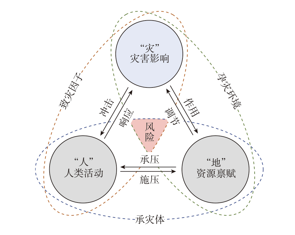
Geography centers on the study of integrated human-environment systems, focusing on the interaction between human activities and the geographical environment. In recent years, the exploration of theories and methodologies related to resilient cities has gradually become a research hotspot in urban geography. However, existing studies on resilient cities within the field of urban geography often rely on the adaptation and transfer of external concepts, lacking integration with the core foundations rooted in the geographic perspective. In response, this article reviewed the developmental trajectory of research on resilient cities, analyzed the geographic connotations of resilient city research, and put forward the following propositions: 1) From the perspective of urban geography, resilient city research should center on the disaster risk-constrained human-environment relationships. 2) The coupled system formed by "human activities-resource endowments-disaster impacts" constitutes the principal framework for investigating resilient cities within urban geography. 3) The interactions between human activities, resource endowments, and disaster impacts across multiple temporal and spatial scales often exhibit complexities, nonlinearities, and instabilities comparable to those of the "three-body problem" in gravitational physics. 4) Both the short-term, sudden disturbances and the long-term, gradual evolution within the human-environment-disaster system can be constrained and regulated through territorial spatial governance measures. This article provides a preliminary exploration of the theory of disaster risk-constrained human-environment relationships, and presents an analysis and verification using the Zhengzhou "7·20" extreme rainstorm disaster event as a case study, aiming to provide a theoretical reference for promoting high-quality and sustainable urban development in China.
The protection and sustainable utilization of black soil are crucial for national food security and the stability of ecological barriers. Systematic and adaptable technical support forms the foundation for implementing this strategy. This study addressed the core issues in the current catalog of black soil conservation and utilization technologies, including inadequate technical adaptability, delayed content updates, and insufficient multi-technology coordination. Through a multidisciplinary approach, we innovatively constructed a multi-tiered theoretical framework encompassing objective layer, principle layer, pathway layer, technology layer, and safeguarding layer. Building upon this, we proposed the regional differentiation, typology classification, standardization, and dynamic updating principles for compiling the catalog. We established a core logic driven by reverse-engineering from the generation mechanism and demonstrated the four-step compilation process using the "Lishu Model" as a typical case. This study innovatively established a multi-tiered theoretical framework and standardized compilation methodology for the technical model catalog of protective utilization of black soil. It provides a core methodological support for the scientific compilation of technical catalogs, achieving a transformation from simple listing to region-adapted systematic solutions. The research outcomes offer a theoretical foundation and practical pathway for black soil conservation and sustainable utilization, holding significant scientific values and practical implications for enhancing the effectiveness of comprehensive black soil management and safeguarding national food security.
Driven by the deep integration of digital technology and the acceleration of regional integration, the smart urban agglomeration (SUA) has emerged as a new paradigm of regional coordinated development and modern governance in the era of digital intelligence. Consequently, it has become a frontier topic in geography, urban planning, and public administration. Based on the perspective of regional synergy, this article systematically reviewed the development context of related research on smart urban agglomerations in China and internationally since 2010. It analyzed its conceptual content and spatial characteristics from the geographical dimension, and summarized research hotspots and development trends. Studies indicate that smart urban agglomeration represents a modern form of regional spatial organization aimed at fostering coordinated regional development, human-centered principles, and sustainable growth. It operates through digital platforms, prioritizes talent, technology, and institutional frameworks as its core elements, relying on cross-regional collaboration networks and regional innovation systems to optimize resource allocation. Defining characteristics include spatial organization that transcends administrative boundaries, highly concentrated digital technological capabilities, and a multi-tiered collaborative governance structure. The current research mainly focuses on four areas: evaluation system construction, regional cooperation system, innovation system evolution, and digital technology empowerment. However, there are still obvious deficiencies in the construction of the theoretical system, the analysis of spatial mechanisms, and the coordination of human-environment relationship. Future research should strengthen investigations into the spatial evolution mechanism, evaluation system, collaborative governance mechanism, and the impact on regional development patterns of smart urban agglomerations, thereby enriching the geographical connotation of urban agglomeration theory in the digital intelligence era.
This study used the CiteSpace software and bibliometric analysis to systematically review the Chinese and international literature on rural inclusive finance from 2005 to 2024, tracing the development stages and the evolution of key themes in this field. Based on this, the article summarized the progress in the research of inclusive finance and rural development, with the aim of unravelling the mechanisms and effects through which inclusive finance influences rural development. Inclusive finance originated from achieving the goal of eliminating financial exclusion. Against the backdrop of global climate change and the new development of globalization, promoting inclusive growth has emerged as a new and critical objective of inclusive finance. As the connotation of inclusive growth continues to broaden, research topics related to inclusive finance and rural development have shifted from an early emphasis on rural poverty alleviation to cutting-edge areas such as rural economic resilience, sustainable livelihoods, and green development. Correspondingly, the exploration of underlying mechanisms has expanded from focusing solely on alleviating credit constraints to encompassing the multifaceted functions of comprehensive financial services. At the same time, digital technologies have significantly improved the spatial accessibility and population coverage of inclusive finance, positioning digital inclusive finance as a central focus of current research. This article systematically synthesized the core issues of inclusive finance in promoting rural inclusive growth and identified directions for further research, aiming to provide valuable insights to advance both the theories and practice in the field of inclusive finance.
With the development of traditional gentrification theory, its research framework has expanded from a single humanistic, social, or economic dimension to a comprehensive consideration of natural ecological spaces and ecosystem services. Against this backdrop, an increasing number of scholars have paid attention to urban issues such as population displacement, environmental protests, and social group displacement caused by urban environmental improvement, climate governance, and resilience strategy implementation, and have linked them to gentrification. Meanwhile, China's urban development is shifting to a new stage dominated by existing urban space renewal and a people-oriented approach. The central government urban work conferences have also listed the construction of green, low-carbon, and resilient cities as a key task. This indicates that environmental improvement gentrification and climate governance gentrification are becoming new research directions in the field of gentrification. Therefore, this article reviewed the overall progress of Western scholars in the research of environmental improvement (environmental, ecological, green) and climate governance (climate, resilience, low-carbon) gentrification, and systematically examined the connotations of the concepts, identification methods, effects of influencing factors, and formation mechanisms of related gentrification. Finally, taking into consideration the current situation of research in China, the prospects of research on environmental improvement and climate governance gentrification in China were prospected.
Originated from Marx's theory of social reproduction, Western reproductive geographies are dedicated to exploring the power relations and spatiotemporal constitution of social reproduction activities within capitalist societies. By reviewing the main theoretical viewpoints and evolutionary trajectory of Western reproductive geographies, this article aimed to integrate these intellectual strands with China's contemporary reproductive geography realities. It sought to envision a research agenda for reproductive geographies with Chinese characteristics and to extract key implications for China's high-quality population development. Beginning with the "Wages for Housework" movement's critique of the production-reproduction dichotomy in the 1970s, Western reproductive geographies have undergone a spatial and scalar turn, an affective and relational turn, and a cyborg and more-than-human turn of social reproduction research. This intellectual evolution guides Chinese geography to explore the localized characteristics of the reproductive labor process, the spatial-temporal transformations arising from changes in reproductive labor relations, the spatial-temporal reshaping resulting from the performativity of reproductive labor practices, and the interactive relationship between reproductive labor and the socioecological environment. To achieve high-quality population development in China, insights from reproductive geographies suggest the need to ensure spatial equity in accessing reproductive resources to optimize population distribution; build fertility-friendly social relations to stabilize the population; uphold social care and support for reproductive laborers to enhance social well-being; and improve the ecological environment and technological standards of reproductive activities to adapt to demographic structural transitions.
Strategic emerging industries, as an important component of new quality productive forces, serve as a key pillar of the modern industrial system and a significant driving force for the Chinese-style modernization. Based on data from Chinese listed companies in strategic emerging industries and their investment-related enterprises, this study systematically analyzed the development trends, spatial pattern changes, and regional division of labor and collaboration patterns of related enterprises in China's strategic emerging industries from the end of the 13th Five-Year Plan period to the end of the 14th Five-Year Plan period. The study revealed that during the 14th Five-Year Plan period, China's strategic emerging industries maintained a positive development trend, particularly standing out during the economic recovery phase in the post-pandemic era. From an industry perspective, related enterprises in strategic emerging industries have increasingly concentrated in key areas such as manufacturing, research and development, business, and finance, while spatially further clustering in major urban agglomerations, including the Beijing-Tianjin-Hebei region, the Yangtze River Delta area, the Pearl River Delta area, Chengdu-Chongqing, and the middle reaches of the Yangtze River, as well as some key provincial capital cities. This has formed an overall pattern centered around the five major urban agglomerations. Both spatial distance and hierarchical distance have imposed constraints on the spatial expansion of strategic emerging industries, and spatial distance played a stronger constraining role. Significant differences existed between different industries within this framework. From the perspective of factors influencing the spatial layout of related enterprises in strategic emerging industries, the entire industries generally tended to locate in areas with a high concentration of core enterprises and their associated businesses, showing a preference for cities with advanced industrial structures. However, spatial layout preferences varied across specific types of industries.
Under the requirements of high-quality development, optimizing and evaluating land resource allocation in resource-based ecologically fragile regions is key to achieving coordinated economic, social, and ecological development. Taking the Lunan Economic Circle as an example, the multi-objective optimization algorithm and entropy-weight TOPSIS were employed to determine the quantitative optimization scheme of land use in 2030; the PLUS model was employed to predict the optimized spatial layout of land use; and the SBM model was employed to measure the multi-period ecological efficiency to quantitatively evaluate the reliability of land use optimization results. The results show that: 1) With the rigid constraint of the arable land red line, although the acreage of arable land in the region decreases by 2030, it remains above the safety baseline, while the areas of construction land, forest land, grassland, and water bodies increase, achieving optimization of total land use and structure. 2) After optimization, scattered arable land is converted to construction land; sloping arable lands in the Yishan-Mengshan-Nishan area are restored to forest and grassland; the wetland ecological space of the Nansi Lake expands; and unused land near mountains and suburbs is orderly developed, resulting in a more rational spatial pattern. 3) After optimization, as the area of ecological land expands, the gross ecosystem product of all counties is improved, and the overall ecological efficiency of the region will improve from 0.29 in 2020 to 0.33 after optimization in 2030, with further reduction in regional disparities. In conclusion, multi-objective optimization considering the economic-social-ecological functions of land can effectively allocate land resources, promote the ecological transition of these resource-based ecologically fragile regions, and accelerate regional sustainable development.
As the digital economy expands, rural tourism micro-enterprises (RTMEs) face challenges in both digital transformation and resilience building. Digital literacy, a key driver of digitalization, is crucial for fostering innovation and resilience, but the mechanisms behind its impact remain unclear. This study investigated how digital literacy influences innovation and resilience in RTMEs, with a particular focus on the mediation role of innovation. Using a mixed-methods approach combining fsQCA and regression analysis, the study surveyed 72 RTMEs from Shuanglang and Wenlin Villages in Yunnan Province, China. A complex mediation model of "digital literacy-innovation vitality-resilience" was proposed. The fsQCA identified key digital literacy configurations, while regression analysis examined their direct and indirect effects on resilience. The findings show that: 1) Five distinct digital literacy configurations foster high innovation vitality, forming a "perception-capture-transformation" chain with multiple equivalent pathways. 2) Innovation vitality acts as a complex mediator between digital literacy and resilience, with some configurations promoting resilience and others hindering it. 3) Digital literacy dimensions are dynamically complementary, with digital survival skills being crucial for aligning innovation and resilience. Without these skills, misalignment between the two occurs. This study provides a theoretical framework for understanding digital literacy's role in enhancing resilience and offers practical recommendations for RTMEs to optimize their digital capabilities. By identifying context-specific pathways, it suggests tailored strategies for sustainable development in rural tourism.
As a core element of urban environments, the vitality of public green spaces serves as a key indicator for measuring the efficiency of urban environmental services and residents' well-being. This study took 93 public green spaces in the main urban area of Nanjing City as empirical cases. It integrated multi-source heterogeneous data, including Baidu Huiyan population location data, street view images, points-of-interest (POIs), road networks, and social media photographs. By comprehensively applying geographic detector analysis, the multi-scale geographically weighted regression (MGWR) model, and the four-quadrant analysis method, the study innovatively constructed a park green space vitality analysis framework based on the interaction between subjective and objective environments from both the global and local perspectives. This enables a multi-scale analysis of the spatiotemporal differentiation characteristics and underlying causes of public green space vitality in Nanjing City. The findings reveal that: 1) The vitality of Nanjing's public green spaces exhibits significant spatial differentiation, presenting a gradient pattern characterized by high-vitality clustering in the central-eastern areas and low-vitality diffusion in the periphery. 2) Globally, user preferences for service facilities and green view index are the core drivers explaining green space vitality, with notable coupling effects among factors. 3) Locally, the influencing mechanisms of green space vitality display significant spatial heterogeneity, with high variability in factors such as service facilities, decorative elements, and functional mix, while the impacts of functional density and infrastructure remain relatively stable. 4) The differentiated synergy of four key factors—transport accessibility, functional configuration, streetscape, and user visual preferences—proves effective in enhancing public green space vitality. The theoretical framework developed in this study implements an analytical strategy of multi-scale diagnosis-spatial differentiation identification-targeted regulation, providing policymakers with scientific tools including hotspot identification, deficiency diagnosis, and intervention priority assessment to support precision planning strategies based on spatial heterogeneity.
Traffic collisions present a global public safety challenge, and they arise from the combined effects of human, vehicle, road, and environment factors within urban transportation systems. While existing studies have predominantly focused on the impact of the built environment on traffic collisions, limited attention has been given to travelers' subjective perception of safety and its interaction with road network characteristics. Using street links in the main urban area of Wuhan City as the basic unit of analysis, this study employed street view imagery and machine learning techniques to evaluate perceived safety at the street link level. Using a four-way decomposition model, we quantitatively analyzed the controlled direct effect (CDE), the reference interaction without mediation (INTref), the pure mediated effect (PIE), and the mediated interaction (INTmed) through which road network characteristics influence traffic collisions via perceived safety. The results show a significant correlation between perceived safety and traffic collisions, indicating the presence of a "perception bias". Furthermore, topological and geometric characteristics of road networks influence traffic collisions through both the CDE and the PIE mediated by perceived safety. Betweenness centrality, diversion ratio, and mean geodesic length also affect traffic collisions through INTref and INTmed with perceived safety, whereas the near-line ratio operates through INTref with perceived safety. Among these pathways, the CDE plays the dominate role, while INTref, PIE, and INTmed contribute minor proportions, demonstrating that perceived safety moderates the magnitude but not the direction of the total effect. The findings elucidate the complex mechanisms by which urban road network characteristics affect traffic collisions from the perspective of perceived safety, providing a theoretical basis for developing road safety design strategies that integrate both objective and subjective considerations.
Against the backdrop of global poverty reduction and China's efforts to consolidate the achievements of poverty alleviation, transport-related social exclusion in mountainous rural areas—stemming from geographic and individual factors—has emerged as a significant determinant of relative poverty. Taking Huangping County in Guizhou Province as a case study and drawing on household survey data from 2019, this study constructed a measurement framework for transport-related social exclusion and employed a binary logit model to empirically analyze its relationship with relative poverty. The results reveal that: 1) Physical disability and lack of motor vehicles were key drivers of relative poverty, as they respectively undermined labor capacity and restricted spatial mobility, thereby exacerbating barriers to social participation. 2) There was marked heterogeneity among different groups regarding the impact of transport disadvantages. Males, individuals of working age, and those with only primary education were more sensitive to disability and lack of transport means, reflecting the high dependence of productive and employment activities on transportation. 3) For groups with junior high school education and above, relative poverty was constrained by a diverse set of factors, including subjective health, transport expenditure, and travel safety, indicating a shift in multidimensional development needs as education levels rise. 4) Frequent travels to the county seat were negatively correlated with relative poverty, suggesting that active integration into the regional economic network can effectively reduce the risk of relative poverty. This study demonstrated that social exclusion and mobility constraints arising from transport disadvantages are important triggers of relative poverty in contemporary mountainous rural areas. The research expanded the micro-level perspective of transport-led poverty reduction, confirmed the role of transport-related social exclusion in the formation of relative poverty, and provided a scientific basis for precisely identifying impoverished groups and formulating differentiated policies.
Tunpu culture in Central Guizhou is a unique regional cultural phenomenon. This study focused on 37 Tunpu traditional villages in Anshun City, Guizhou Province, and their intangible cultural heritage (ICH) projects at or above the provincial level, using a comprehensive evaluation model, a factor contribution model, and the kernel density estimation method to evaluate the living state of ICH within these villages. Furthermore, it identified the types of the living state of ICH in villages and revealed corresponding spatial distribution patterns. The results show that: 1) The overall living state of ICH in Tunpu traditional villages is suboptimal, with pronounced polarization across different dimensions. 2) Anshun Dixi Opera exhibits the highest levels in both its living state and stability among the individual ICH projects, and the largest number of villages in the study area have advantages in the living state of performance ICH. 3) The types of the living state of ICH in Tunpu traditional villages are classified as: synergistic advantage, characteristic agglomeration, potential activation, enhancement driven, restoration and improvement, and adjustment and restructuring. Spatially, the high-density core area is located at the border between Xixiu and Pingba districts. 4) Overall, the average living state of ICH in Tunpu traditional villages is higher in Xixiu District than in Pingba District. The research results are in line with the actual situation, and provide a scientific basis for the sustainable development of ICH in Tunpu traditional villages.
Amid accelerating global population aging, elderly sojourn behavior has emerged as a critical phenomenon with profound socioeconomic implications. The geographic mobility patterns and settlement intentions of elderly sojourners are reshaping urban demographic landscapes and recalibrating public resource allocation dynamics, posing novel governance challenges for destination cities. This study used Sanya City (China's premier tropical coastal retirement destination) as a representative case to investigate elderly sojourn dynamics through a tripartite analytical framework. Using origin-destination (O-D) matrix analysis based on elderly preferential travel card data (2016-2020), we first delineated the spatiotemporal change of elderly sojourners' mobility patterns. Subsequently, multilevel logistic regression models based on the 2021 questionnaire survey data (N=150) revealed determinants of their settlement intentions. Finally, we put forward differentiated governance strategies. The results show that: 1) There was a phased spatial progression characterized by Northeast China dominance (51.17% of elderly sojourners)-regional node expansion-nationwide dispersion-COVID-19 induced contraction, and the migration showed a seasonal tidal effect, with the majority of the migrant population aged 65-75 years. 2) Elderly sojourners in Sanya demonstrated higher education level and family disposable income, typically accompanied by a spouse and suffering from chronic diseases. Their settlement intention was significantly affected by family factors, migration patterns, and community environment. Those in the family-oriented migration and long-term migration categories had a higher probability of settling down, while a housing area exceeding 65 m2 and a residence adjacent to hospitals can significantly improve their willingness to stay. 3) Based on migration cycles and settlement intentions, elderly sojourners were categorized into four groups: seasonal long-term sojourners, seasonal short-term sojourners, permanent long-term sojourners, and permanent short-term sojourners. This research expanded the theoretical framework of elderly sojourn research through its multiscalar methodology integrating macro-scale mobility mapping with micro-level behavioral analysis, offering evidence-based policy recommendations for elderly sojourner-responsive urban governance. The findings particularly inform destination cities' strategies for joint management mechanism, seasonal infrastructure management, and differentiated community services tailored to elderly sojourn characteristics in aging societies.
In recent years, extreme weather events are increasingly frequent, severely impacting human mobility and socioeconomic activities. Ensuring the robustness of intra-city mobility is essential for the development of resilient cities. However, existing studies primarily focused on physical infrastructure or routine mobility patterns, with insufficient understanding of the spatial mechanisms of human mobility changes under external disturbances. This study constructed the "weather-environment-behavior" framework by combining spatial behavior and disaster risks. Based on mobile phone signaling data, the spatiotemporal characteristics of human mobility in Shanghai under the influence of Typhoon Bebinca are identified, and the driving mechanisms including weather conditions, traffic environment, built environment, and socioeconomic factors are analyzed through geographically weighted regression (GWR). Key findings include: 1) Human mobility in Shanghai was severely impacted during the typhoon and lasted for a long time, showing a clear "decline-recovery" process and rebound after the disaster. Mobility intensity showed negative correlation with weather conditions in time series. 2) Mobility patterns showed ring-shaped spatial differentiation, with the central urban area and distant suburbs experiencing severe fluctuations and impacts, while the near suburbs were less affected. In temporal terms, the central urban area exhibited gradual response patterns, while the peripheral area exhibited sensitive response patterns. 3) Changes of mobility were influenced by different factors in a spatially non-stationary manner: central urban areas were primarily affected by rainfall duration and travel distance, suburban areas were primarily affected by travel intensity and land use mix, while remote suburban areas were influenced by factors including transportation infrastructure, land use functions, and public service levels. Socioeconomic factors contributed to shock mitigation in most peripheral areas. It will be helpful to enhance the adaptability of the city by alleviating overcrowding in urban centers, defining the dominant functions of new towns, increasing employments, and improving infrastructures. This study aimed to provide a scientific basis for urban planning, traffic management, and emergency response, promoting urban safety, resilience, and sustainable development.
Yi-Fu Tuan's Segmented worlds and self: Group life and individual consciousness is a seminal work of existential geography, specifically focusing on the alienation and fragmentation that characterize modern spatial experiences. Unlike Tuan's more widely recognized texts such as Topophilia and Space and Place, which celebrate the emotional and sensory bonds between humans and their environment, this book takes a critical turn to explore the darker side of human spatial existence—the processes through which individuals and communities become increasingly disconnected from the spaces they inhabit. By tracing the phenomenological trajectory of this alienating relationship, the book articulates its mechanisms through the interplay of three central concepts: the self, body perception, and horizon. This article highlights that this book departs from Tuan's other works by adopting a unique phenomenological lens. Rather than emphasizing the harmonious or affective dimensions of "being-in-the-world", it foregrounds the existential condition of alienation. The book takes a transcendental self as its philosophical starting point, inheriting and expanding upon Maurice Merleau-Ponty's theory of body perception and explores the isomorphic relationship between the enhancement of self-awareness and spatial separation, grounding his analysis in specific historical and cultural contexts. Furthermore, inspired by Levinas' concept of horizon, the book envisions a path toward reconstructing a holistic man-land relationship in the context of postmodern disembedding. Tuan extends the idea to the realm of geography, proposing that the reintegration of fragmented spaces and selves requires a revived body perception of our interconnectedness with places. To phenomenologically unravel the narrative thread within the book, to start with, this article initially contrasts Tuan's concept of self with David Ley's, placing them within the framework of two branches of humanistic geography: explications of experience and interpretations of social worlds. Tuan and Ley, as representatives of each branch, respectively view the self as transcendental versus socially constructed. Consequently, their phenomenological entry points diverge, with Tuan emphasizing body perception from Merleau-Ponty and Ley focusing on social activity drawing from George Mead's Symbolic Interactionism and Alfred Schutz's Theory of Intersubjectivity. This transcendental perspective allows Tuan's self to serve as the phenomenological subject, rather than activity or symbol. Second, guided by body perception, Tuan introduces the concept of embodiment as a bridge connecting self and space/place, concurrently forming the notions of embodied self and embodied space/place. Historically exploring the isomorphic relationship between self and space/place through the transformation of body perception, the book illustrates this relationship in three contexts: food, housing, and theater. It reveals how the heightened sense of vision, accompanied by the decline of other senses, leads to the segmentation of social space, subsequent disembedding from life worlds, and the alienation of the man-land relationship. In conclusion, this book reflects on approaches to rebuilding a holistic man-land relationship from the perspective of place horizon. Current studies of Tuan's geographical thoughts in China tend to emphasize the being-in-the-world perspective while neglecting the alienation dimension. This article proposes a simultaneous intertwining of both perspectives by exploring the latter within the book.
 Big Data
 GSC
GSC