温康民 , 任国玉, 李娇
WEN Kangmin, REN Guoyu, LI Jiao
通讯作者:
收稿日期: 2018-05-10
修回日期: 2018-12-20
网络出版日期: 2019-04-28
版权声明: 2019 地理科学进展 《地理科学进展》杂志 版权所有
基金资助:
作者简介:
第一作者简介:温康民(1992— ),男,江西赣州人,博士生,研究方向为气候变化。E-mail: wenkangmin@126.com
展开
摘要
城市化偏差是中国地面气温观测记录中最大的系统性偏差,订正该偏差可为大尺度气候变化监测和研究提供准确的基础资料。论文介绍了用于单站地面月平均气温序列城市化偏差订正的一个方法,并利用该方法订正了685个国家基本/基准站1961—2015年地面年及月平均气温序列中的城市化偏差。采取自东往西迭代订正的方法,即从东往西逐经度订正,订正完的目标站也可作为参考站。首先,规定目标站的参考站在300 km范围内,并利用2站的去线性趋势年均气温的相关系数作为标准,规定相关系数最大且通过信度水平为0.005显著性检验的4个候选参考站作为该目标站的参考站;然后,对各个参考站年均气温与其对应目标站年均气温求相关,并以其平方为权重计算各参考站月和年均气温的平均值序列,即为各目标站年和月平均地面气温参考序列;其次,利用目标站气温序列趋势及其参考序列趋势之差作为总的订正值,订正目标站气温序列中包含的城市化偏差。较大的城市化偏差出现在华北地区、华中部分地区、东北北部、西南及西部部分地区,介于0.1~0.3 ℃/10 a;在中国西北部分地区、西藏西部及南部、东北南部、华南沿海、华东及华中个别站存在负偏差;对整个中国而言,相对城市化偏差为19.6%。以北京、武汉、银川、深圳作为华北、华中、西北和华南地区的大城市代表站,发现其在过去55 a的相对城市化偏差分别为67.0%、75.4%、32.7%和50.3%,与前人针对单站评估城市化影响的结果基本一致,说明论文的订正方法较为合理。论文介绍的城市化偏差订正方法,可用于订正中国等快速城市化地区地面气温观测资料的系统偏差,订正后的气温数据在很大程度上消除了城市化因素引起的不确定性。
关键词:
Abstract
This study developed a method for correcting urbanization bias of station monthly mean surface air temperature data. By using this method and the data of 143 reference stations obtained from a previous research, we corrected urbanization bias of annual and monthly mean temperature data from 1961 to 2015 for 685 national reference climate and basic weather stations (national stations). We explained the rationality and evaluated the effect of the adjustment in the monitoring and analysis of surface air temperature change in the mainland of China. This study adopted a method of iterative correction that corrects longitudinally from east to west, and a revised target station can also serve as a reference station. First, the reference stations of a target station was set as within the range of 300 km, and the correlation coefficients of the detrended annual mean temperature between the target and candidate reference stations were taken as the criteria for selecting the reference stations. Second, by using the correlation coefficients of the reference stations as weights, the weighted average of the annual and monthly mean temperature of all the reference stations around a target station was calculated, obtaining annual and monthly mean temperature reference series for each of the target stations. Third, urbanization biases of the target stations were adjusted by using the linear temperature trend differences of the target station and the reference series as the total correction amounts. The areas with large adjustments are located in North China, part of Central China, northern Northeast China, part of Southwest China, and western China, ranging from 0.1 to 0.3 ℃/10 a, and negative urbanization bias exists in some areas of northwestern China, western and southern Tibet, southern Northeast China, coastal South China, and a few stations in East and Central China. For the whole of China's mainland, the relative urbanization bias is 19.6%. As representative metropolis observational sites in North China, Central China, Northwest and South China, respectively, Beijing, Wuhan, Yinchuan, and Shenzhen stations are found to have larger relative adjustments of 67.0%, 75.4%, 32.7%, and 50.3% respectively in the past 55 years. The adjustments are in line with the results of previous studies on assessment of impacts of urbanization for the stations. The results show that the adjustment is reasonable. The corrected temperature data largely have eliminated the uncertainties caused by urbanization biases.
Keywords:
城市化影响是中国地面气温观测数据出现系统偏差的重要来源之一(Ren et al, 2008; 张爱英等, 2010; Yang et al, 2011; Wang et al, 2017)。尽管很多研究定量评价了城市化对中国较大区域范围平均地面气温序列的影响(任玉玉等, 2010),其中绝大多数研究发现城市化影响非常显著。20世纪末,赵宗慈(1991)利用全国160站1951—1989年各月气温资料,对中国城市化影响气温变化作了深入分析,得出大城市年平均增暖明显,变暖大约0.27~0.45 ℃,小城市变暖很少,平均变暖大约0.04~0.12 ℃。Portman(1993)利用 1954—1983年华北平原气温资料,以8个乡村站为参考站,研究得出:21个城市站年平均气温城市化偏差为0.19 ℃/30 a,其中7个大城市站为0.26 ℃/30 a,14个小城市站为0.15 ℃/30 a。
21世纪初,相关学者利用城市减乡村的方法,发现我国部分甚至整个地区的地面气温受城市化影响显著。Zhou等(2004)利用中国东南部1979—1998气温资料,分析发现年平均气温的城市化偏差为0.05 ℃/10 a。初子莹等(2005)利用1961—2000年北京20个台站,分析得到国家基本、基准站城市化偏差为0.16 ℃/10 a,城市化贡献率为71.0%。周雅清等(2005)对1961—2000年间华北地区地表气温观测中城镇化影响进行检测,发现国家基本、基准站相对城市化偏差达到37.9%。陈正洪等(2005)利用湖北省71个气象站1961—2000年间气温资料,分析武汉站相对郊区代表站,全省的城市代表站、基本和基准站相对乡村代表站的热岛增温贡献率,发现年平均气温的热岛增温贡献率分别为64.5%、75.0%及60.0%以上。唐国利等(2008)分析了西南地区国家基准/基本站、大城市站、小城市站、乡村站1961—2004年的气温变化特征,计算了国家基准/基本站和城镇站地面气温中的相对城市化偏差,发现大中城市站和国家站的相对城市化偏差分别为57.6%和45.3%,小城市的相对城市化偏差为19.9%。张爱英等(2010)利用全国范围614个国家基本/基准站和138个乡村站1961—2004年气温资料,采用城市减乡村的方法,得出中国地面年均气温趋势中含有0.08 ℃/10 a的城市化影响,城市化贡献率为27.33%。
近年来,研究人员利用再分析资料、土地利用数据及卫星遥感数据等,分析发现城市化对我国气温影响明显。Yang等(2011)利用包括中国东部1981—2007年一般和国家基本、基准站,和NCEP/NCAR再分析资料共463个气象站的月平均气温,得出中国东部相对城市化偏差为24.2%。Yang等(2013)利用安徽52个气象站,并根据土地利用和土地覆盖数据,将其分为城市站、郊区站和乡村站,分析发现1970—2008年间,城市站受城市化影响最为严重,年平均、年最高、年最低气温的城市化贡献率分别为35.82%、14.29%和45.16%。Wu 等(2013)利用中国东部312个气象站1979—2008年均一化订正气温资料和DMSP/OLS夜间灯光数据,使用空间滤波方法检测了不同空间尺度的气温趋势,发现长三角地区夏季变暖主要源于最大温度的显著增加,且城市化偏差为0.13~0.25 ℃/10 a,相对城市化偏差为36.0%~68.0%;京津冀地区冬季变暖主要因为最低气温的显著增加,且城市化偏差为0.10~0.21 ℃/10 a,相对城市化偏差为12.0%~24.0%。He等(2013)利用北京、天津、河北共69个没有迁站的气象站1978—2008年温度资料及历史遥感数据,发现该区域过去30 a增温速率为0.3 ℃/10 a,城市化偏差为44.1%。Li等(2013)利用中国1979—2010年274站温度数据和NCEP/NCAR再分析数据,通过OMR(Observation Minus Reanalysis)的方法来检测城市化影响,认为核心大城市的增暖速率为0.22 ℃/10 a,边缘型小城市的增暖速率为0.12 ℃/10 a。
最近,Sun等(2016)利用中国2419个气象站1961—2013年均一化月平均气温资料,得到1961—2013年期间中国的温度增加了1.44 ℃,相对城市化偏差为33.3%。Wang等(2017)利用中国753站1980—2009年均一化日气温数据集、ERA-Interim再分析数据集、土地覆盖数据集,分析了中国东部气温变化中的城市化偏差,得出中国东部平均及最低日气温中相对城市化偏差分别为4.0%、9.0%。同时指出城市站气温资料序列城市化偏差订正的必要性(任国玉等, 2005; 张爱英等, 2010; Yang et al, 2013; Bian et al, 2015),但迄今尚未发展出一套建立在对城市化影响科学评估和可靠方法订正基础上的国家基本/基准站地面气温数据集。造成这种局面的主要原因有两方面:一是缺少一个较为合理的用于全国范围内单站气温序列中的城市化偏差订正的技术方案,二是长期以来对这套气温资料所构成的不同区域和不同类型台站中的城市化偏差,缺乏一个系统的估计值。
Karl等(1988)对美国1219个观测台站附近居民点人口数据和其热岛增温速率建立回归方程,订正区域和单站平均气温和平均最高、最低气温资料,指出这个回归方程在美国之外的其他地区并不一定适用;Gallo等(1999)利用城乡气温差值同地表辐射温度、卫星反演的归一化植被指数(NDVI)的城乡差值对比,获得显著的相关关系,指出基于卫星遥感和基于人口的城市化订正具有相同的误差量级;Portman(1993)利用均一化检验后的华北地区站点,剔除包含间断点的站点,并去除各站点经纬度、海拔高度不一致造成的偏差,对城市和乡村站温度序列求差值,获得城市站区域平均的城市化订正公式;Choi等(2003)利用城市和乡村台站资料序列趋势的差值方法订正了韩国年平均和各个季节的城镇站区域平均序列;Hansen等利用两段式线性趋势订正单个城市的城市化影响,是以假定在研究的两个时段之内城市化增温是线性增加为前提的(Hansen et al, 1999; Hansen et al, 2001)。Fujibe(2009)利用城市站为中心的周边一定圆形范围内的人口密度为依据,将日本的气象站分为6类,并且将第1类和第2类站点作为参考站,订正并分析了第3至第6类站点中的城市化偏差。
在中国,周雅清等(2005)和张爱英等(2009)利用研究时段内城镇站温度趋势减乡村站温度趋势的方法订正了城镇站区域平均温度序列,获得消除城市化偏差后的区域平均气温距平序列(表1)。城-乡站趋势差值方法避免了人口数据质量、回归方程调整检验等一系列问题。这种方法建立在假设整个研究时期内城市化对地面气温趋势影响是准线性的基础之上。但是,迄今尚没有开展站点基础上的国家级气象站地面气温城市化偏差订正工作。对于普遍具有较大城市化偏差的中国地面气温观测资料来说,这种局面无助于大尺度气候变化监测和研究工作的深入。
表1 中国及区域地面气温中城市化偏差的评价
Tab.1 Assessment of urbanization bias for surface air temperature in China
| 文献 | 地区 | 时段 | 数据集 | 结果 |
|---|---|---|---|---|
| 赵宗慈(1991) | 中国 | 1951—1989年 | 160站月平均气温 | 大城市和次大城市39 a平均增暖约0.27 ℃和0.45 ℃,次小城市和小城市变暖约0.12 ℃和0.04 ℃ |
| Portman(1993) | 华北地区 | 1954—1983年 | 60站气候要素和205站气温和降水数据集 | 21个城市站年平均气温城市化偏差为0.19 ℃/30 a,其中7个大城市站为0.26 ℃/30 a,14个小城市站为0.15 ℃/30 a |
| Zhou等(2004) | 中国东南部 | 1979—1998年 | 671站月平均最高和最低气温,NCEP R-2再分析数据 | 年平均温度的城市化偏差为0.05 ℃/10 a |
| 初子莹等(2005) | 北京地区 | 1961—2000年 | 北京地区20站月平均温度 | 国家基本、基准站城市化偏差为0.16 ℃/10 a,城市化贡献率为71.0% |
| 张爱英等(2005) | 山东省 | 1963—2002年 | 山东省88个国家基本/基准站及一般站月平均气温 | 国家基本/基准站和城市站年平均气温的城市化影响贡献率分别为27.2%和21.7% |
| 周雅清等(2005) | 华北地区 | 1961—2000年 | 华北地区282站月平均气温 | 国家基本、基准站相对城市化偏差为37.9% |
| 陈正洪等(2005) | 湖北省 | 1961—2000年 | 湖北省71站逐月地表平均、最高、最低气温 | 年平均气温相对城市化偏差武汉为64.5%,全省城市代表站可达75.0%以上,全省基本和基准站可达60.0%以上 |
| 白虎志等(2006) | 甘肃省 | 1961—2002年 | 甘肃省38站月平均、平均最高、平均最低气温 | 基本/基准站和城市站年平均温度的城市化贡献率分别为18.5%、37.6% |
| 唐国利等(2008) | 西南地区 | 1961—2004年 | 西南地区322站月平均气温 | 相对城市化偏差大中城市站和国家站分别为57.6%和45.3%,小城市为19.9% |
| 张爱英等(2010) | 中国 | 1961—2004年 | 2300站均一化月平均气温 | 国家基本、基准站地面年平均气温中相对城市化偏差为27.3% |
| Yang等(2011) | 中国东部 | 1981—2007年 | 463站月平均气温和NCEP/NCAR再分析气温 | 中国东部相对城市化偏差为24.2% |
| Ren等(2011) | 中国 | 1961—2004年 | 672国家基本/基准站均一化月气温 | 国家基本/基准站年平均温度中的城市化影响偏差为0.06 ℃/10 a,城市化影响贡献率为23.0% |
| Yang等(2013) | 安徽省 | 1970—2008年 | 安徽52站月平均、平均最高、平均最低气温 | 年平均、年最高、年最低气温的城市化贡献率分别为35.82%、14.29%和45.16% |
| Wu等(2013) | 中国东部 | 1979—2008年 | 中国东部312站均一化日平均气温 | 长三角地区夏季相对城市化偏差为36.0%~68.0%,京津冀地区冬季相对城市化偏差为12.0%~24.0% |
| He等(2013) | 河北省 | 1978—2008年 | 京津冀地区69站月平均气温 | 相对城市化偏差为44.1% |
| Li等(2013) | 中国 | 1979—2010年 | 752站月气温和NCEP/NCAR再分析月平均气温 | 核心大城市和边缘型小城市的增暖速率分别为0.22 ℃/10 a和0.12 ℃/10 a |
| Ren等(2015) | 中国 | 1961—2004年 | 825基本/基准站均一化月气温 | 国家基本/基准站年平均温度中的城市化影响为0.074 ℃/10 a,城市化贡献率为24.9% |
| Wang等(2015) | 中国 | 1951—2010年 | 728基本/基准站均一化月气温 | 在站点水平上,强城市化站点和中度城市化影响站点的城市化影响贡献率分别为24%和21% |
| Sun等(2016) | 中国 | 1961—2013年 | 2419站均一化月气温和CMIP56气候模式月平均气温 | 相对城市化偏差为33.3% |
| Wang等(2017) | 中国东部 | 1980—2009年 | 753站均一化日气温和ERA-中期再分析数据 | 中国东部日平均及最低气温中相对城市化偏差分别为4.0%、9.0% |
本文采用本课题组前期分析调查得到的地面气温参考站网,建立了一个订正城镇站网地面月平均气温城市化偏差的方法,并利用此方法对国家基本/基准站网地面月平均气温序列作了城市化偏差订正,建立了一套基于较为全面的城市化偏差订正技术体系订正城市化偏差后的国家基本/基准站月平均地面气温(包括最高气温、最低气温和平均气温)历史资料数据集。
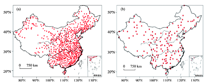
本文所用资料为中国气象局国家气象信息中心提供的“国家级地面气象站均一化气温月值数据集”(国家气象信息中心, 2013),该资料包含中国2419个国家级台站1951—2016年均一化逐月平均气温、逐月平均最高气温、逐月平均最低气温,由月平均气温可以得到年平均气温。在中国,研究气候变化的基础数据通常是利用国家基准/基本站(国家站)的观测资料,因此,本文对825个国家站的气温月值数据作城市化偏差订正,即剔除气温记录中的城市化偏差(系统误差),得到基本不包含该系统偏差的气温数据。考虑到上述资料中1961年以前及2016年中气温资料缺测较多,故选定时间范围为1961—2015年。其次,规定在1961—2015年间缺测率不超过2%,即缺测不超过13个月,得到764个国家基本/基准站。对于目标站中的缺测值,采用缺测年为中心的前后各5 a共10 a平均值替代。最后,去除143个参考站中的79个国家基本/基准站,最终得到685个国家基本/基准站用于城市化偏差订正和分析(图1)。在685个目标站的月数据中,有575个目标站没有缺测,缺测1个月的目标站有60个,缺测2个月的目标站有13个,缺测3个月的目标站有7个,缺测4个月的目标站有8个,缺测5、6、7、8、9、10、11、12、13个月的目标站分别只有6、8、1、1、2、1、1、1、1个。
图1 中国685个国家基本/基准站(a)和143个参考站(b)空间分布
注:本图基于国家测绘地理信息局标准地图服务网站下载的审图号为GS(2016)1569号的标准地图制作,底图无修改。下同。
Fig.1 Distribution of the 685 national basic and standard stations (a) and 143 reference stations (b) in the mainland of China
利用任国玉等(2010)、Ren等(2015)建立的143个中国大陆地面气温参考站网。此参考站网是由全国范围2400个长序列观测站中挑选的,对台站观测连续性和历史资料的起止年份、迁站次数、观测点附近聚落人口数量、观测场周围12 km2范围内人工建筑的比率、测站与附近城镇中心的距离等诸多信息进行了充分考虑,最终在中国大陆区域共挑选出143个参考站。云南的巍山站附近周围分布数座砖窑,代表性已经恶化;巍山站附近的漾濞站观测环境符合参考站遴选条件。经过重新评估之后,删除了巍山站,增补漾濞站。在所有参考站中,79个为国家基本/基准站,64个为国家一般站。143个参考站的月平均地面气温资料来源同上,对于个别参考站中的缺测值,采用缺测年为中心的前后各5 a共10 a平均值替代。
对于每个目标站,其附近都应有一定数量的参考站。参考站距目标站最远距离由研究、监测的目的和气候变量类型决定。对于全球的大陆尺度而言,较稀疏的站网密度(平均每1000~2000 km一个站)就可以满足地面气温变化研究和监测的目的(Peterson et al, 1997);对于次大陆尺度而言,监测大尺度地面气温变化则有更高的要求,需要辨别区域尺度气候变化因子的影响,这要求台站平均距离保持在500 km以内(Janis et al, 2004; 任玉玉等, 2012)。
在构建每个目标站的参考站时,本文参考了气候数据质量控制中检验空间一致性的邻站选取法(Karl et al, 1987; Mitchell et al, 2005; 李庆祥, 2011)。将分布在以某站为圆心,某一距离为半径的圆内的参考站当作该目标站的参考站。求算2站间距离的公式为:
式中:
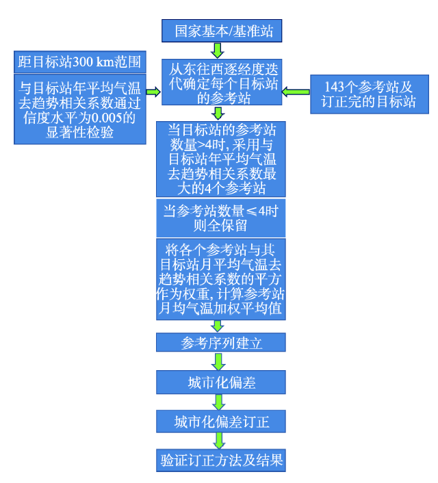
要比较区域内的城乡差别,首先要消除(或消减)大尺度气候变化格局,因此,本文要求参考站和目标站之间相距不超过300 km。其次,为确保青藏高原中西部和东北参考站分布较稀疏的地区,任意目标站也能够选出参考站,本文采取自东往西迭代订正的方法,即从东往西逐经度订正,并把订正完的目标站作为候选参考站。
对城镇站距参考站距离进行规定后,再考虑候选参考站与目标站地面气温年际、年代际变异的一致性,即考察它们是否处在同一个自然气候子区。因此,利用去线性趋势的2站年均气温的相关系数作为标准。去线性趋势的温度序列主要体现地面气温在年际、年代际尺度上的变异性。利用一元线性回归分析得到线性趋势方程,剔除时间序列中的趋势项,获得目标站和参考站去趋势的年均气温序列。计算各目标站与其各候选参考站去趋势年均、月均气温的相关系数,要求候选参考站的相关系数通过信度水平为0.005的显著性检验(t0.005=0.364),才能作为这个目标站的参考站。
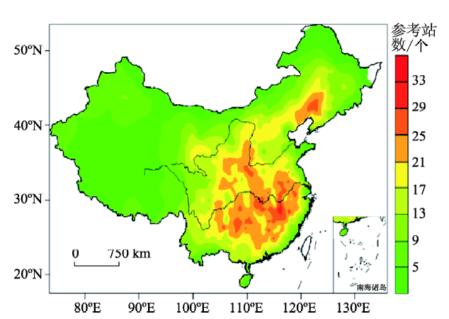
表2给出具有不同参考站数量的目标站数目,及其占所有目标站的百分比。发现666个目标站具有至少3个参考站,占所有目标站的97.4%。具有至少8个参考站的目标站大约占到82.5%,仅有1~2个参考站的目标站只有18个。图2展示了各目标站的参考站数量分布,不难发现海南、东北北部、内蒙古北部、新疆、西藏,以及山东半岛和江苏、上海、浙江沿海地区及东南沿海地区目标站的参考站数量较少,在13个以下;在华中、华东、华北,以及东北南部的目标站的参考站数量较多,在17个以上。
表2 对应不同数量参考站的目标站数及其百分比
Tab.2 Number of urban stations with different numbers of reference stations and their percentages
| 目标站数及百分比 | 参考站数/个 | ||||||
|---|---|---|---|---|---|---|---|
| 27~32 | 21~26 | 13~20 | 8~12 | 5~7 | 3~4 | 1~2 | |
| 目标站数/个 | 26 | 160 | 263 | 115 | 75 | 27 | 18 |
| 百分比/% | 3.8 | 23.4 | 38.5 | 16.8 | 11.0 | 3.9 | 2.6 |
| 累积百分比/% | — | 27.2 | 65.7 | 82.5 | 93.5 | 97.4 | 100 |
图2 目标站对应的参考站数量分布
Fig.2 Distribution of the number of reference stations corresponding to the target stations
得到能代表目标站周围背景气温变化的参考序列是订正城市化偏差的关键,因此构建目标站的单一参考序列的方法至关重要。
有研究发现,要插补单站缺测气温资料,利用和其具有最高相关性的4个邻近站计算获得的插补值有较高精度(余予等, 2012);也有研究表明,在订正中国降水序列的均一性中,参考序列的构建中以从相距最近的20个站中挑选相关系数最大的3个站较为合适(江志红等, 2008)。参考前人的方法,由于过多的参考站参加计算会引入噪声,本文规定当目标站的参考站多于4个时,根据年均气温去趋势的相关系数,将相关性最大的4个站作为最后的参考站;当参考站数目≤4时则全部选取。
按照上述评判标准,685个国家基本/基准站共筛选出2681个参考站。表3列出了和目标站有不同等级相关系数的参考站数及其百分比。发现目标站和参考站普遍具有较好的相关性,其中92.1%的参考站相关系数在0.80以上,仅有0.8%的参考站相关系数在0.60以下。
表3 目标站不同等级相关系数的参考站数及其百分比
Tab.3 Number of reference stations (frequency) with different correlation coefficients with annual mean temperature of urban stations and their percentages
| 参考站数及百分比 | 相关系数 | 合计 | ||||
|---|---|---|---|---|---|---|
| 0.90~1.00 | 0.80~0.90 | 0.70~0.80 | 0.60~0.70 | 0.38~0.60 | ||
| 参考站数/个 | 1640 | 830 | 160 | 29 | 22 | 2681 |
| 百分比/% | 61.2 | 30.9 | 6.0 | 1.1 | 0.8 | 100 |
| 累积百分比/% | — | 92.1 | 98.1 | 99.2 | 100 | |
对于各目标站,将其去趋势月均气温序列与其各参考站去趋势月均气温序列的相关系数的平方值作为权重,求算参考站月均地面气温序列的加权平均,获得各目标站1961—2015年间月均地面气温序列的参考序列。
在大尺度气候变化研究中,主要关注气候要素的线性趋势变化及其统计显著性。本文借鉴张爱英等(2009)的线性订正方法,利用研究时段目标站的线性趋势减参考序列的线性趋势差值作为总的订正值,订正目标站的城市化偏差。根据这种方法,订正过的城镇站的地面气温序列线性趋势和其对应参考序列的地面气温线性趋势是相同的。该方法是以两个假设为前提的:① 构建的某个目标站的参考序列气温线性趋势能够代表此区域大尺度的背景气温的变化趋势;② 目标站平均地面气温受城市化的影响是线性增加的,即城市化影响在各年份是近似的。近年来,研究人员将城镇站气温的趋势减对应的参考序列气温趋势的差定义为城市化增温率或城市化影响(初子莹等, 2005; Ren et al, 2008)。订正目标站地面气温数据中的城市化偏差,就是在各年的基础上剔除城市化影响等量值。
张爱英等(2009)的订正是从目标站序列的最早年份开始,向后逐渐递减平均每年的城市化影响,订正过的序列代表剔除城市化偏差的区域平均气温序列[式(2)]。为方便未来观测数据可以直接更新而不必逐年订正,本文修改如下:以目标站序列最晚年份(本文为2015年)作为基准,向前逐渐递加平均每年的城市化影响,订正过的序列把站点当前及未来最近几年的气温作为固定值,新的气温资料在未来数年内具有更好的可延展性(式(3))。
式中:
按照上述方法,对685个站1961—2015年逐月平均地面气温资料进行城市化偏差订正,建立了一套国家基本/基准站地面月平均气温(包括最高气温、最低气温和平均气温)城市化偏差订正资料数据集。
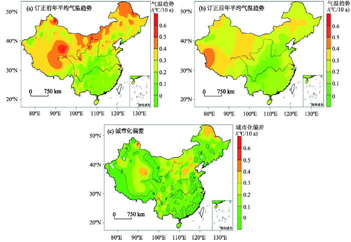
为了了解订正效果及其合理性,采用对比前人针对单站城市化偏差评价研究的方法,对本文城市化偏差订正方法和订正结果的合理性进行验证。首先比较订正前后685个站1961—2015年的年平均气温线性趋势及其差值分布(图4)。由图4a可见,城市化偏差订正前,年平均气温增温趋势在中国东北、华北、西北、西南及华东沿海地区较大,大部分地区介于0.3 ℃/10 a~0.6 ℃/10 a;而在华东、华中及华南地区,年平均气温增温趋势较小,大部分地区介于0.1 ℃/10 a~0.3 ℃/10 a。城市化偏差订正后(图4b),年平均气温增温趋势在中国东北、华北部分地区、新疆、西藏、西北部分地区、华东部分地区仍然较大,普遍介于0.2 ℃/10 a~0.4 ℃/10 a,而在华北、华中、华南及华东部分地区,年平均气温增温趋势较小,普遍介于0~0.2 ℃/10 a;相比订正前温度变化的零散分布,订正后的温度变化趋势分布相对集中,且呈带状,这更加符合中国真实气候变化及气候带的分布;此外,订正后的增温趋势在全国广泛明显地下降,这些均表明了城市化偏差明显存在于中国国家基本/基准站地面气温资料中。由图4c可以直观地看出,城市化偏差较大的地区分布在华北地区、华中部分地区、东北北部地区、西南部分地区、新疆及西藏部分地区,介于0.1 ℃/10 a~0.3 ℃/10 a,而在中国西北部分地区、西藏西部及南部存在负偏差,这是由于在干燥地区,受绿洲效应影响,随着绿洲的扩大,城市站夏秋季节具有变凉趋势,乡村站相对城市站出现增温趋势,而在中国东北南部、华南沿海、华东及华中个别站,可能由于参考站和目标站增温趋势差异很小,甚至参考站有可能选取在邻近平原上较大乡镇站,出现相对增温现象,所以在上述地区的城市站呈现出负的城市化偏差。这与Ren等(2015)和张爱英等(2010)研究得出的华北、中国中东部、中国沿海地带城市站存在显著为正的城市化偏差(其值介于0.10 ℃/10 a~0.25 ℃/10 a),而在中国西北地区、中国东北南部、西南部分地区的城市站存在显著为负的城市化偏差的结论一致,表明本文城市站的城市化偏差订正具有一定合理性。此外,利用网格面积加权法(Jones et al, 1996),估算得到中国区域城市站的相对城市化偏差为19.6%。
图4 中国685国家基本/基准站城市化偏差订正前(a)、订正后(b)年平均气温趋势及城市化偏差(c)空间分布
Fig.4 Distribution of yearly mean surface air temperature trends before (a) and after (b) urbanization bias correction and urbanization bias (c) in 685 national basic and standard stations in the mainland of China
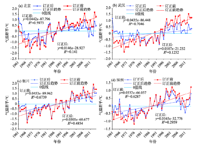
考虑站点分布的均匀性和资料可用性,选取北京、武汉、银川和深圳这4个站分别作为华北、华中、西北、华南的大城市代表站,对订正结果进行检验。
图5展示了4个具有代表性的城市站订正前和订正后的年均地面气温时间序列。表4展示了4个代表站城市化偏差订正前后气温序列的各统计量,以及城市化影响的表征指标。可以发现,相比订正之前,城市化偏差订正后,各站的年均气温均值稍有增加,方差则明显减小,研究时段内增温趋势显著降低。订正之前,气温序列中包含的城市化偏差非常显著,与全国平均年地面气温增温速率处于一个数量级上(任国玉等, 2005),其中北京和武汉站分别达到0.296 ℃/10 a和0.328 ℃/10 a,深圳和银川站分别为0.167 ℃/10 a和0.148 ℃/10 a;相对城市化偏差北京、武汉分别达到67.0%、75.4%,深圳和银川站分别为50.3%和32.7%。
图5 代表站订正前后的年平均地面气温距平序列和线性趋势
Fig.5 Mean annual temperature anomalies and linear trends of the original and urban-bias adjusted data for representative urban stations
表4 代表性城市站城市化偏差订正前和订正后的统计量及城市化影响的表征指标
Tab.4 Statistical characteristics of four urban stations before and after urban-bias adjustment and the urban effects for the original temperature series
| 站名 | 站号 | 气温趋势/(℃/10 a) | 均值/℃ | 方差/℃ | 城市化偏差 /(℃/10 a) | 相对城市化 偏差/% | |||||
|---|---|---|---|---|---|---|---|---|---|---|---|
| 订正前 | 订正后 | 订正前 | 订正后 | 订正前 | 订正后 | ||||||
| 北京 | 54511 | 0.442** | 0.146 | 12.413 | 13.220 | 0.838 | 0.385 | 0.296** | 67.0 | ||
| 武汉 | 57494 | 0.435** | 0.107** | 15.545 | 16.423 | 0.689 | 0.234 | 0.328** | 75.4 | ||
| 银川 | 53614 | 0.453** | 0.305** | 9.247 | 9.637 | 0.780 | 0.493 | 0.148** | 32.7 | ||
| 深圳 | 59493 | 0.332** | 0.165** | 22.665 | 23.128 | 0.45 | 0.236 | 0.167** | 50.3 | ||
1961—2015年北京站订正前的年平均地面气温增加速率为0.442 ℃/10 a,订正后降至0.146 ℃/10 a。订正之前的气温序列中,城市化偏差及相对城市化偏差分别为0.296 ℃/10 a和67.0%。订正以后增温速率明显降低,但年代际的波动振幅非常一致。初子莹等(2005)将北京附近的斋堂、霞云岭、佛爷顶、怀柔、汤河口和上甸子当作参考站,发现北京站1961—2000年间的城市化偏差为0.26 ℃/10 a,和本文分析结果非常接近;司鹏等(2009)研究发现,北京站1960—2006年间年均地面气温的城市化影响为0.22 ℃/10 a,稍低于本文结果。Yan等(2010)估计北京站1977—2006年间城市化偏差介于0.20 ℃/10 a~0.54 ℃/10 a,与本文研究结果相一致。由于选取参考站的方法、资料处理方法和研究时段明显不同,本文与前人针对相当长度时间序列研究结果的差别可以说是很小的,表明本文参考站的选取和参考序列的建立方法是合理的。
订正城市化影响以前武汉站的年均气温增加速率为0.435 ℃/10 a,订正城市化影响之后降低至0.107 ℃/10 a。前人的研究利用武汉周边的新洲、黄陂、蔡甸和江夏4站当作参考站,计算得出武汉1961—2000年的城市化偏差是0.20 ℃/10 a,相对城市化偏差为64.5%(陈正洪等, 2005; Ren et al, 2007);对1960—2005年武汉站城市化偏差的更新评估结果为:城市化偏差为0.24 ℃/10 a,相对城市化偏差为60.4%(陈正洪等, 2007)。本文根据迭代订正的方法,得到1961—2015年武汉站年平均气温城市化偏差为0.328 ℃/10 a,相对城市化偏差为75.4%,略高于前人分析结果,这可能主要由于本文选取的参考站和参考序列长度与前人不同,但武汉年平均气温序列中存在较严重的城市化偏差的结论是一致的。
本文获得银川站城市化影响订正以前和订正之后的年均地面气温增加趋势分别为0.453 ℃/10 a和0.305 ℃/10 a。订正前序列的城市化偏差为0.148 ℃/10 a,相对城市化偏差为32.7%。李凤琴等(2009)选取银川市郊区的贺兰、灵武、永宁为参考站,发现银川站1951—2007年年平均气温变化趋势约为0.357 ℃/10 a,3个参考站的城市化偏差分别为-0.072 ℃/10 a、0.217 ℃/10 a和-0.279 ℃/10 a;出现城市化偏差为负的情况,主要是参考站中还包含了极大的城市化偏差,原则上此类站点不宜作为代表背景气候变化的乡村站,若是采用这类参考站作为背景站,将会得到偏大的增温趋势,由于参考站选取的不同及研究时段的差异,严格意义上说其结果与本文是不具有可比性的。
分析得到深圳站订正前后1961—2015年期间的年平均地面气温变化趋势分别为0.332 ℃/10 a和0.165 ℃/10 a,城市化偏差为0.167 ℃/10 a,相对城市化偏差为50.3%。司鹏等(2010)利用深圳附近的台山、惠阳、斗门、上川岛和汕尾5站当作参考站,求得1967—2005年深圳的城市化影响为0.12 ℃/10 a,相对城市化偏差则为37%,相比本文估计的结果偏低。造成这一差别的主要原因是研究时段及选取参考站的方法不同。张恩洁等(2007)发现,深圳站1953—2004年间年平均地面气温上升速率为0.34 ℃/10 a,与本文计算结果接近。Chen等(2006)通过分析卫星遥感反演的亮度温度,发现了20世纪90年代以后深圳城市热岛强度和影响区域快速增加的现象,说明深圳站地面气温记录明显受到城市化的影响,与本文所得结论基本一致。
城市化偏差是站点气温记录中最常见的系统偏差,量化并剔除地面气温记录中的城市化偏差,得到去除城市化偏差的大规模温度平均值,对于气候变化研究和推进我们对气候变化的了解,具有重要意义。
确定城市化偏差最直接的方法是将每个城市站与被认为不受城市化影响的邻近(最好是乡村)站进行比较,本文制定了订正单站月平均地面气温资料序列的城市化偏差的方法,包括挑选目标站对应的参考站的方法、构建目标站的参考序列的方法及线性订正城市化偏差的方法,并利用该方法订正了685个国家基本/基准站1961—2015年年及月平均地面气温资料序列的城市化偏差。最后,通过与以往对单站城市化偏差评价研究的结果进行对比,对本文城市化偏差订正方法和订正结果的合理性进行验证。结果表明,本文发展的订正方法和获得的订正后的国家基本/基准站数据集具有一定的客观性和合理性。需要指出的是,由于中国近几十年的飞速发展,之前选取的乡村站也将或多或少地受到城市化的影响,因此,由于参考站的不确定性,本文获得的城市化偏差可以认为是最低值,今后仍需选取更为严格的参考站。
本文获得的这套订正后的国家基本/基准站资料,可以认为基本剔除了城市化偏差,利用这套资料分析研究现代气候变化,可以得到更为真实的全国和各区域地面气温长期变化趋势时空特征。因此,这套数据不仅对气候变化监测以及检测、模拟研究,而且对于气候变化影响评估,均具有重要价值。尤其是,农业领域和水资源领域的气候变化影响评估,需要区域背景气候变化信息,本数据集可以满足相应需要。
The authors have declared that no competing interests exist.
| [1] |
城市热岛效应对甘肃省温度序列的影响 [J].Magsci 摘要
对甘肃省若干国家基本/基准站、城市站和乡村站1961-2002年共42年季、年平均温度资料等进行了对比分析。结果表明:城市站和国家基本/基准站比乡村站增温趋势显著。近40多年来城市热岛效应对基本/基准站年平均温度的增温贡献率为18.5%,对城市站年平均温度的增温贡献率为37.6%。季节增温率冬季最大,秋季次之,春夏季最小;城市热岛效应对季节增暖的贡献率则为春季最大,夏季次之,秋冬季最小。
The effect of urban heat island on change of regional mean temperature in Gansu Province, China .Magsci 摘要
对甘肃省若干国家基本/基准站、城市站和乡村站1961-2002年共42年季、年平均温度资料等进行了对比分析。结果表明:城市站和国家基本/基准站比乡村站增温趋势显著。近40多年来城市热岛效应对基本/基准站年平均温度的增温贡献率为18.5%,对城市站年平均温度的增温贡献率为37.6%。季节增温率冬季最大,秋季次之,春夏季最小;城市热岛效应对季节增暖的贡献率则为春季最大,夏季次之,秋冬季最小。
|
| [2] |
武汉市城市热岛强度非对称性变化 [J].https://doi.org/10.3969/j.issn.1673-1719.2007.05.007 URL Magsci [本文引用: 1] 摘要
利用武汉市区气象站及其周边4个县气象站1960-2005年的气温资料,计算了46 a及分时段的季节和年平均气温、平均最高和最低气温倾向率,城市热岛强度倾向率及其贡献率。结果表明:46 a来,城区和郊区的平均气温均以上升趋势为主,最低气温增幅最大,最高气温增幅最小,甚至下降;冬季增幅最快,夏季增幅最慢,甚至下降,这是第一类非对称性。 城市热岛效应也存在增强趋势,以年平均、最低和最高气温表示的城市热岛强度倾向率分别为0.235℃/10 a、0.425℃/10 a和0.034℃/10 a,热岛效应贡献率分别达到60.4%、67.7%和21.8%,这是第二类非对称性。 46 a来的增温和城市热岛强度加强主要是最近23 a快速增温所致,进入本世纪增温进一步加剧。摘要 计算了武汉市气象站、周边4县气象站平均的1960~2005年间以及前后两半时段四季和年平均、最高、最低气温倾向率,城市热岛强度倾向率和贡献率。结果表明:1)46年来,城区和郊区的平均气温均以增趋势为主,平均气温倾向率为正,最低气温增幅最大,最高气温增幅最小甚至下降,冬季增幅最快,夏季增幅最慢甚至下降,这是第一类非对称性;2)城市热岛效应也存在增趋势,以年平均、最低、最高气温表示的城市热岛强度倾向率分别为0.235、0.425、0.034 ℃/10a,热岛效应贡献率分别达到60.4%、67.7%、21.8%,这是第二类非对称性,3)46年来的增温和城市热岛强度加强主要是后23年快速增温所致,前23年气温变化不明显。武汉市气象站气温资料严重地保留着城市化影响,建议尽快迁站。关键词 城市热岛强度 最高气温 最低气温 非对称性变化
Asymmetrical change of urban heat island intensity in Wuhan, China .https://doi.org/10.3969/j.issn.1673-1719.2007.05.007 URL Magsci [本文引用: 1] 摘要
利用武汉市区气象站及其周边4个县气象站1960-2005年的气温资料,计算了46 a及分时段的季节和年平均气温、平均最高和最低气温倾向率,城市热岛强度倾向率及其贡献率。结果表明:46 a来,城区和郊区的平均气温均以上升趋势为主,最低气温增幅最大,最高气温增幅最小,甚至下降;冬季增幅最快,夏季增幅最慢,甚至下降,这是第一类非对称性。 城市热岛效应也存在增强趋势,以年平均、最低和最高气温表示的城市热岛强度倾向率分别为0.235℃/10 a、0.425℃/10 a和0.034℃/10 a,热岛效应贡献率分别达到60.4%、67.7%和21.8%,这是第二类非对称性。 46 a来的增温和城市热岛强度加强主要是最近23 a快速增温所致,进入本世纪增温进一步加剧。摘要 计算了武汉市气象站、周边4县气象站平均的1960~2005年间以及前后两半时段四季和年平均、最高、最低气温倾向率,城市热岛强度倾向率和贡献率。结果表明:1)46年来,城区和郊区的平均气温均以增趋势为主,平均气温倾向率为正,最低气温增幅最大,最高气温增幅最小甚至下降,冬季增幅最快,夏季增幅最慢甚至下降,这是第一类非对称性;2)城市热岛效应也存在增趋势,以年平均、最低、最高气温表示的城市热岛强度倾向率分别为0.235、0.425、0.034 ℃/10a,热岛效应贡献率分别达到60.4%、67.7%、21.8%,这是第二类非对称性,3)46年来的增温和城市热岛强度加强主要是后23年快速增温所致,前23年气温变化不明显。武汉市气象站气温资料严重地保留着城市化影响,建议尽快迁站。关键词 城市热岛强度 最高气温 最低气温 非对称性变化
|
| [3] |
湖北省城市热岛强度变化对区域气温序列的影响 [J].https://doi.org/10.3969/j.issn.1006-9585.2005.04.008 URL [本文引用: 1] 摘要
计算湖北省71个气象站1961~2000年间四季、年平均、最低、最高气温倾向率,绘制其等值线分布图,设计并求取武汉站相对郊区代表站、全省的城市代表站、基本和基准站相对乡村代表站的热岛增温速率和贡献率。结果表明1)40年来气温倾向率多为正,即呈增温趋势,但时空分布不均,冬季最低气温增速大,夏季最高气温增速小甚至降温,非对称性变化明显,几乎所有情况后20年增温加剧;2)武汉站、全省城市代表站热岛效应影响存在着显著的随时间增大趋势,武汉年平均、最低、最高气温的热岛增温速率分别为0.2、0.37、0℃/10a,贡献率分别为64.5%、67.3%、0%,而全省城市代表站年3项气温的热岛增温速率略小,贡献率则可达75%以上,有些情况可达100%,且时间差异、非对称性特征与武汉较一致;3)近40年来全省基本和基准站热岛增温贡献率可达60%以上,近20年来还有50%左右。因此,目前根据国家基本、基准站资料建立的温度序列严重地保留着城市化影响。
Change of urban heat island intensity and its effect on regional temperature series: A case study in Hubei Province .https://doi.org/10.3969/j.issn.1006-9585.2005.04.008 URL [本文引用: 1] 摘要
计算湖北省71个气象站1961~2000年间四季、年平均、最低、最高气温倾向率,绘制其等值线分布图,设计并求取武汉站相对郊区代表站、全省的城市代表站、基本和基准站相对乡村代表站的热岛增温速率和贡献率。结果表明1)40年来气温倾向率多为正,即呈增温趋势,但时空分布不均,冬季最低气温增速大,夏季最高气温增速小甚至降温,非对称性变化明显,几乎所有情况后20年增温加剧;2)武汉站、全省城市代表站热岛效应影响存在着显著的随时间增大趋势,武汉年平均、最低、最高气温的热岛增温速率分别为0.2、0.37、0℃/10a,贡献率分别为64.5%、67.3%、0%,而全省城市代表站年3项气温的热岛增温速率略小,贡献率则可达75%以上,有些情况可达100%,且时间差异、非对称性特征与武汉较一致;3)近40年来全省基本和基准站热岛增温贡献率可达60%以上,近20年来还有50%左右。因此,目前根据国家基本、基准站资料建立的温度序列严重地保留着城市化影响。
|
| [4] |
北京地区城市热岛强度变化对区域温度序列的影响 [J].https://doi.org/10.3321/j.issn:0577-6619.2005.04.015 URL Magsci [本文引用: 2] 摘要
通过对北京地区20个台站1961~2000年月平均温度资料的对比分析,证实热岛效应对城市气象站记录的地表平均气温的绝对影响随时间显著增大,近20 a尤为突出,但其相对影响即热岛增温对全部增暖的贡献却呈下降趋势。近40 a来,北京地区的国家基本、基准站平均温度距平序列与被认为不受城市热岛影响的郊区站平均温度距平序列差异明显,由于热岛效应加强因素引起的国家基本、基准站平均年温度变化速率为0.16 ℃/(10 a),对整个时期全部增温的贡献达到71%;近20 a来热岛效应加强因素使北京地区国家基本、基准站年平均温度每10 a增暖0.33 ℃,对该时期全部增温的贡献达到49%。城市热岛效应加强因素对国家基本、基准站季节平均温度上升的贡献在夏、秋季高,冬季最小。本文的结果说明,目前根据国家基本、基准站资料建立的全国或较大区域平均温度序列可能在很大程度上保留着城市化的影响,有必要做进一步的检验和订正。
Change in urban heat island magnitude and its effect on mean air temperature record in Beijing region .https://doi.org/10.3321/j.issn:0577-6619.2005.04.015 URL Magsci [本文引用: 2] 摘要
通过对北京地区20个台站1961~2000年月平均温度资料的对比分析,证实热岛效应对城市气象站记录的地表平均气温的绝对影响随时间显著增大,近20 a尤为突出,但其相对影响即热岛增温对全部增暖的贡献却呈下降趋势。近40 a来,北京地区的国家基本、基准站平均温度距平序列与被认为不受城市热岛影响的郊区站平均温度距平序列差异明显,由于热岛效应加强因素引起的国家基本、基准站平均年温度变化速率为0.16 ℃/(10 a),对整个时期全部增温的贡献达到71%;近20 a来热岛效应加强因素使北京地区国家基本、基准站年平均温度每10 a增暖0.33 ℃,对该时期全部增温的贡献达到49%。城市热岛效应加强因素对国家基本、基准站季节平均温度上升的贡献在夏、秋季高,冬季最小。本文的结果说明,目前根据国家基本、基准站资料建立的全国或较大区域平均温度序列可能在很大程度上保留着城市化的影响,有必要做进一步的检验和订正。
|
| [5] |
中国国家级地面气象站均一化气温月值数据集(V1.0)评估报告 [M].Monthly dataset of homogenized temperature for national ground meteorological station (V1.0) Assessment Report . |
| [6] |
近50年中国降水序列均一性检验与订正研究 [J].https://doi.org/10.3878/j.issn.1006-9585.2008.01.09 URL [本文引用: 1] 摘要
选取中国近50年(1951~2004年)月降水资料中具有连续观测20年以上记录的681个台站资料,通过对各站年代际分量的EOF分析及North判别检验,结合标准正态检验(SNHT)方法,发现所检站点中约有4%的台站降水序列存在非均一性。利用比值法对非均一降水序列进行了订正,结果表明对年降水序列的订正量在-3%~7%之间。必须注意的是,由于我国现有台站观测网的密度不够,影响了对非均一降水序列的订正精度。
Study of precipitation series homogeneous adjustment and their correction over China in the last 50 years .https://doi.org/10.3878/j.issn.1006-9585.2008.01.09 URL [本文引用: 1] 摘要
选取中国近50年(1951~2004年)月降水资料中具有连续观测20年以上记录的681个台站资料,通过对各站年代际分量的EOF分析及North判别检验,结合标准正态检验(SNHT)方法,发现所检站点中约有4%的台站降水序列存在非均一性。利用比值法对非均一降水序列进行了订正,结果表明对年降水序列的订正量在-3%~7%之间。必须注意的是,由于我国现有台站观测网的密度不够,影响了对非均一降水序列的订正精度。
|
| [7] |
近50年来城市化对银川市区局地气候的影响 [J].https://doi.org/10.3969/j.issn.1671-7244.2009.04.003 URL [本文引用: 1] 摘要
根据银川市基准站1951—2007年气温、降水、相对湿度、日照时间等资料,对受城市化影响的气候(城市气候)指标分别做5a滑动平均曲线,并与银川市的郊区——贺兰站、灵武站和永宁站1960—2007年的资料进行比较.结果表明,银川市出现了比较明显的"城市热岛"效应.1960—2007年,银川站与贺兰站、灵武站和永宁站的年平均气温之差的变化趋势基本一致,1980年前变化比较平缓,1980年后,平均气温差迅速上升,特别是2000年以后升幅更大.受城市化的影响,银川市区的降水量变化基本上是波动增加的,年总降水量超过贺兰站、灵武站和永宁站.随着城市规模的发展,银川市的"干岛效应"为增强趋势;而"暗岛效应"是从20世纪90年代以后才逐渐显现的.
Urbanization effects on local climate in Yinchuan in recent 50 years .https://doi.org/10.3969/j.issn.1671-7244.2009.04.003 URL [本文引用: 1] 摘要
根据银川市基准站1951—2007年气温、降水、相对湿度、日照时间等资料,对受城市化影响的气候(城市气候)指标分别做5a滑动平均曲线,并与银川市的郊区——贺兰站、灵武站和永宁站1960—2007年的资料进行比较.结果表明,银川市出现了比较明显的"城市热岛"效应.1960—2007年,银川站与贺兰站、灵武站和永宁站的年平均气温之差的变化趋势基本一致,1980年前变化比较平缓,1980年后,平均气温差迅速上升,特别是2000年以后升幅更大.受城市化的影响,银川市区的降水量变化基本上是波动增加的,年总降水量超过贺兰站、灵武站和永宁站.随着城市规模的发展,银川市的"干岛效应"为增强趋势;而"暗岛效应"是从20世纪90年代以后才逐渐显现的.
|
| [8] |
|
| [9] |
中国气温变化研究最新进展 [J].https://doi.org/10.3969/j.issn.1006-9585.2005.04.001 [本文引用: 2] 摘要
总结了“十五”攻关课题有关中国温度变化研究的若干进展。在资料质量控制和序列非均一性检验及订正的基础上,更新了中国地面近50年、100年和1000年气温序列。研究表明,不论是近54年还是近100年全国年平均地面气温升高趋势一般比原来分析结果表明的要强,分别达到0·25℃/10a和0·08℃/10a。中国现代增暖最明显的地区包括东北、华北、西北和青藏高原北部,最显著的季节在冬季和春季。近50多年中国近地面气候变暖主要是平均最低气温明显上升的结果,全国范围内极端最低气温也显著升高,而极端最高气温升高不多。中国与温度相关的极端气候事件强度和频率一般呈降低趋势或稳定态势。研究发现,城市化因素对中国地面平均气温记录具有显著影响,但在现有的全国和区域平均温度变化分析中一般没有考虑,因此需要在将来的研究中给予密切关注。在增温明显的华北地区,1961~2000年间城市化引起的年平均气温增加值达到0·44℃,占全部增温的38%,城市化引起的增温速率为0·11℃/10a。中国其他地区的增温趋势中也或多或少反映出增强的城市热岛效应影响。20世纪60年代初以来中国对流层中下层温度变化趋势不明显,仅为0·05℃/10a,比地面气温变化小一个量级;对流层上层和平流层底层年平均温度呈明显下降趋势,变化速率分别为-0·17℃/10a和-0·22℃/10a;整个对流层平均温度呈微弱下降趋势。中国对流层温度与地面气温变化趋势存在明显的差异,但这种差异在20世纪80年代初以后趋于减小。近千年来中国地面气温变化史上可能确存在“中世纪温暖期”和“小冰期”等特征性气候阶段,但“中世纪温暖期”的温暖程度似乎没有过去认为的那样明显。从全国范围看,11世纪末和13世纪中的温暖程度可能均超过了20世纪30~40年代暖期,表明20世纪的增暖可能并非史无前例。中国20世纪气候增暖的原因目前还不能给出明确回答。一些迹象表明,人类活动可能已经对中国的地面气温变化产生了影响,但太阳活动及气候系统内部的低频振动对现代气候变暖可能也具有重要影响。
Recent progresses in studies of regional temperature changes in China .https://doi.org/10.3969/j.issn.1006-9585.2005.04.001 [本文引用: 2] 摘要
总结了“十五”攻关课题有关中国温度变化研究的若干进展。在资料质量控制和序列非均一性检验及订正的基础上,更新了中国地面近50年、100年和1000年气温序列。研究表明,不论是近54年还是近100年全国年平均地面气温升高趋势一般比原来分析结果表明的要强,分别达到0·25℃/10a和0·08℃/10a。中国现代增暖最明显的地区包括东北、华北、西北和青藏高原北部,最显著的季节在冬季和春季。近50多年中国近地面气候变暖主要是平均最低气温明显上升的结果,全国范围内极端最低气温也显著升高,而极端最高气温升高不多。中国与温度相关的极端气候事件强度和频率一般呈降低趋势或稳定态势。研究发现,城市化因素对中国地面平均气温记录具有显著影响,但在现有的全国和区域平均温度变化分析中一般没有考虑,因此需要在将来的研究中给予密切关注。在增温明显的华北地区,1961~2000年间城市化引起的年平均气温增加值达到0·44℃,占全部增温的38%,城市化引起的增温速率为0·11℃/10a。中国其他地区的增温趋势中也或多或少反映出增强的城市热岛效应影响。20世纪60年代初以来中国对流层中下层温度变化趋势不明显,仅为0·05℃/10a,比地面气温变化小一个量级;对流层上层和平流层底层年平均温度呈明显下降趋势,变化速率分别为-0·17℃/10a和-0·22℃/10a;整个对流层平均温度呈微弱下降趋势。中国对流层温度与地面气温变化趋势存在明显的差异,但这种差异在20世纪80年代初以后趋于减小。近千年来中国地面气温变化史上可能确存在“中世纪温暖期”和“小冰期”等特征性气候阶段,但“中世纪温暖期”的温暖程度似乎没有过去认为的那样明显。从全国范围看,11世纪末和13世纪中的温暖程度可能均超过了20世纪30~40年代暖期,表明20世纪的增暖可能并非史无前例。中国20世纪气候增暖的原因目前还不能给出明确回答。一些迹象表明,人类活动可能已经对中国的地面气温变化产生了影响,但太阳活动及气候系统内部的低频振动对现代气候变暖可能也具有重要影响。
|
| [10] |
我国地面气温参考站点遴选的依据、原则和方法 [J].[本文引用: 1] 摘要
由于城市化和观测环境变化的影响,我国现有国家级气象台站网观测的地面气温资料许多已不能满足气候变化检测研究的要求。利用我国全部气象观测站网的台站信息,对地面气温资料序列质量进行了系统评价,遴选出可用于气温变化研究的参考站点。这项工作建立了地面气温参考站点遴选的原则、方法和步骤,并据此确定了138个地面气温参考站。这些台站可代表背景地面气温场,其长期气温观测资料可用作城市台站或国家级台站城市化增温评价的参考,也可直接用于我国地面气温变化的检测分析。
Principles and procedures for selecting reference surface air temperature stations in China .[本文引用: 1] 摘要
由于城市化和观测环境变化的影响,我国现有国家级气象台站网观测的地面气温资料许多已不能满足气候变化检测研究的要求。利用我国全部气象观测站网的台站信息,对地面气温资料序列质量进行了系统评价,遴选出可用于气温变化研究的参考站点。这项工作建立了地面气温参考站点遴选的原则、方法和步骤,并据此确定了138个地面气温参考站。这些台站可代表背景地面气温场,其长期气温观测资料可用作城市台站或国家级台站城市化增温评价的参考,也可直接用于我国地面气温变化的检测分析。
|
| [11] |
城市化对地面气温变化趋势影响研究综述 [J].https://doi.org/10.11820/dlkxjz.2010.11.006 URL Magsci [本文引用: 1] 摘要
<p>在综述城市化对地面气温资料序列影响研究进展的基础上,总结评估了不同空间尺度上地面气温序列中城市化影响的性质和强度。在城市台站和局地尺度上,多数研究均发现城市化对地面气温序列影响明显;区域尺度的研究主要集中在中国、美国和欧洲等少数地区,研究结果存在较大的差异,但采用严格遴选乡村站资料的分析都得到了城市化影响很明显的结论。在中国大陆地区,国家级气象台站年平均地面气温的上升趋势中,至少有27.3%可归因于城市化影响;对于全球或半球陆地平均气温序列而言,研究工作还很不充分,但一般认为城市化影响较小,可能不超过总增温的10%。现有研究还表明,城市化对地面气温序列的影响随时间和区域有不同的表现;城市化对包括中国在内的东亚地区近半个世纪长序列地面气温趋势的影响是非常显著的,但对欧洲地区的明显影响可能主要发生在20 世纪早期甚至19 世纪后期。目前的研究仍然存在一些问题和困难,其中包括研究覆盖的区域和时间段有限、乡村站遴选标准不统一、城市化影响偏差订正方法有待完善等。</p>
An overview of researches of urbanization effect on land surface air temperature trends .https://doi.org/10.11820/dlkxjz.2010.11.006 URL Magsci [本文引用: 1] 摘要
<p>在综述城市化对地面气温资料序列影响研究进展的基础上,总结评估了不同空间尺度上地面气温序列中城市化影响的性质和强度。在城市台站和局地尺度上,多数研究均发现城市化对地面气温序列影响明显;区域尺度的研究主要集中在中国、美国和欧洲等少数地区,研究结果存在较大的差异,但采用严格遴选乡村站资料的分析都得到了城市化影响很明显的结论。在中国大陆地区,国家级气象台站年平均地面气温的上升趋势中,至少有27.3%可归因于城市化影响;对于全球或半球陆地平均气温序列而言,研究工作还很不充分,但一般认为城市化影响较小,可能不超过总增温的10%。现有研究还表明,城市化对地面气温序列的影响随时间和区域有不同的表现;城市化对包括中国在内的东亚地区近半个世纪长序列地面气温趋势的影响是非常显著的,但对欧洲地区的明显影响可能主要发生在20 世纪早期甚至19 世纪后期。目前的研究仍然存在一些问题和困难,其中包括研究覆盖的区域和时间段有限、乡村站遴选标准不统一、城市化影响偏差订正方法有待完善等。</p>
|
| [12] |
城市化对深圳气温变化的贡献 [J].https://doi.org/10.3969/j.issn.1674-7097.2010.01.014 URL [本文引用: 1] 摘要
Based on homogenized land surface air temperature data at Shenzhen and its neighboring stations and the National Centers for Environmental Prediction/Department of Energy(NCEP/DOE)Atmospheric Model Intercomparison Project(AMIP)-Ⅱ Reanalysis(R-2)data,urbanization effects on temperature change in Shenzhen was estimated.The linear trends of temperature for both the observed and R-2 data were estimated by using the Robust Regression(M estimation),then the contributions of urban heat island(UHI) to the climate w...
Urbanization-induced surface air temperature change at Shenzhen .https://doi.org/10.3969/j.issn.1674-7097.2010.01.014 URL [本文引用: 1] 摘要
Based on homogenized land surface air temperature data at Shenzhen and its neighboring stations and the National Centers for Environmental Prediction/Department of Energy(NCEP/DOE)Atmospheric Model Intercomparison Project(AMIP)-Ⅱ Reanalysis(R-2)data,urbanization effects on temperature change in Shenzhen was estimated.The linear trends of temperature for both the observed and R-2 data were estimated by using the Robust Regression(M estimation),then the contributions of urban heat island(UHI) to the climate w...
|
| [13] |
城市化对北京气温变化的贡献分析 [J].https://doi.org/10.3969/j.issn.1004-4574.2009.04.023 URL [本文引用: 1] 摘要
采用均一化订正后的地面观测最高、最低气温资料及NCEP/DOE AMIP-Ⅱ Reanalysis(R-2)再分析温度数据,分别研究分析了北京地区城市化引起的气温增暖影响。结果表明,城市化对北京地区气温的年/季节增暖影响非常显著,并且在整个时期的春、冬季气温升高尤为突出。发现由北京台站与背景气候的地面观测资料比较得到的城市热岛效应导致的增暖贡献过程主要发生在1960-2006年,其对年平均气温的增暖贡献为44.8%;而采用实测资料与R-2背景气候资料对比得到的城市化对气温增暖的影响主要表现在1979-2006年,其对地面年平均气温增暖贡献达73.5%,但利用同时期城一乡台站观测资料分离得到的热岛效应贡献水平则仅为34.4%。通过两种不同的思路对城市化影响进行分析,可以弥补传统的城市气候研究方法的不足,为对中国局地气候变化的人类活动影响的认识提供重要的参考依据。
Contribution of urbanization to ehange of air temperature in Beiiing .https://doi.org/10.3969/j.issn.1004-4574.2009.04.023 URL [本文引用: 1] 摘要
采用均一化订正后的地面观测最高、最低气温资料及NCEP/DOE AMIP-Ⅱ Reanalysis(R-2)再分析温度数据,分别研究分析了北京地区城市化引起的气温增暖影响。结果表明,城市化对北京地区气温的年/季节增暖影响非常显著,并且在整个时期的春、冬季气温升高尤为突出。发现由北京台站与背景气候的地面观测资料比较得到的城市热岛效应导致的增暖贡献过程主要发生在1960-2006年,其对年平均气温的增暖贡献为44.8%;而采用实测资料与R-2背景气候资料对比得到的城市化对气温增暖的影响主要表现在1979-2006年,其对地面年平均气温增暖贡献达73.5%,但利用同时期城一乡台站观测资料分离得到的热岛效应贡献水平则仅为34.4%。通过两种不同的思路对城市化影响进行分析,可以弥补传统的城市气候研究方法的不足,为对中国局地气候变化的人类活动影响的认识提供重要的参考依据。
|
| [14] |
西南地区城市热岛强度变化对地面气温序列影响 [J].Change of urban heat island intensity and its effect on surface mean air temperature records in Southwest China . |
| [15] |
标准序列法在日平均气温缺测数据插补中的应用 [J].https://doi.org/10.7519/j.issn.1000-0526.2012.9.014 URL [本文引用: 1] 摘要
Based on the daily mean air temperature from 1971 to 2000 observed by more than 2000 national surface stations in China, a standardized method was employed to carry out missing data estimation experiment, and the results were verified by cross validation. Two schemes, the relation optimal scheme and the closest station scheme, which were both used to pick up the adjacent stations, were compared. It showed that the relation optimal scheme was better than the other, and only 4 adjacent stations that are most closely related to the estimated station were necessary for estimation. The results indicated that estimate values in average deviate from true values by 0.42℃. The absolute mean error and root mean square error between the estimation and the actural measurements and the sample ratio with the differences falling in ±0.5℃ were all shown good exponential relationships with the average adjacent station distance.
Application of standardized method in estimating missing daily mean air temperature .https://doi.org/10.7519/j.issn.1000-0526.2012.9.014 URL [本文引用: 1] 摘要
Based on the daily mean air temperature from 1971 to 2000 observed by more than 2000 national surface stations in China, a standardized method was employed to carry out missing data estimation experiment, and the results were verified by cross validation. Two schemes, the relation optimal scheme and the closest station scheme, which were both used to pick up the adjacent stations, were compared. It showed that the relation optimal scheme was better than the other, and only 4 adjacent stations that are most closely related to the estimated station were necessary for estimation. The results indicated that estimate values in average deviate from true values by 0.42℃. The absolute mean error and root mean square error between the estimation and the actural measurements and the sample ratio with the differences falling in ±0.5℃ were all shown good exponential relationships with the average adjacent station distance.
|
| [16] |
国家基本基准站地面气温序列中城市化影响的检测与订正 [D].Detection and correction to national basic data station sequence of surface temperature on the impact of urbanization . |
| [17] |
山东省城市化对区域平均温度序列的影响 [J].https://doi.org/10.3969/j.issn.1006-9585.2005.04.006 URL 摘要
对山东省国家基本/基准站、代表性的城市站与代表性的乡村站1963~2002年共40年的月、季、年平均温度资料进行了对比分析,并对济南站进行了个例研究.从增温趋势看出,城市站和国家基本/基准站比乡村站增温趋势显著.近40年来城市热岛效应增强因素对基本/基准站年平均温度的增温贡献率为27.22%,对所选城市站年平均温度的增温贡献率为21.71%,济南站为23.43%.城市热岛效应增强因素对季节增暖的贡献以夏季为最大,其次是春季和秋季,而冬季最小.因此,目前根据国家基本/基准站资料建立的山东或华北地区平均温度序列在一定程度上保留着城市化的影响,有必要做进一步的检验和订正.
Urban heat island effect on change of regional mean temperature over Shandong Province, China .https://doi.org/10.3969/j.issn.1006-9585.2005.04.006 URL 摘要
对山东省国家基本/基准站、代表性的城市站与代表性的乡村站1963~2002年共40年的月、季、年平均温度资料进行了对比分析,并对济南站进行了个例研究.从增温趋势看出,城市站和国家基本/基准站比乡村站增温趋势显著.近40年来城市热岛效应增强因素对基本/基准站年平均温度的增温贡献率为27.22%,对所选城市站年平均温度的增温贡献率为21.71%,济南站为23.43%.城市热岛效应增强因素对季节增暖的贡献以夏季为最大,其次是春季和秋季,而冬季最小.因此,目前根据国家基本/基准站资料建立的山东或华北地区平均温度序列在一定程度上保留着城市化的影响,有必要做进一步的检验和订正.
|
| [18] |
中国地面气温变化趋势中的城市化影响偏差 [J].https://doi.org/10.11676/qxxb2010.090 URL Magsci [本文引用: 4] 摘要
在中国大陆2300个气象台站网中遴选出138个参考站,对614个国家级气象站和138个参考站1961—2004年的月平均气温资料进行了非均一性检验和订正,利用REOF(旋转主分量)分析方法,按照气温变率空间相关特点将中国大陆划分为6大区域,并采用经纬度网格面积加权平均法分别建立了中国大陆及其6大区域平均的国家站和参考站的月、季、年地面气温时间序列,对国家站和参考站序列进行了对比分析。结果表明,由国家站资料建立的中国大陆年平均气温序列在44年间线性增温率为0.278 ℃/10 a,而由参考站资料建立的中国大陆年平均气温序列同期增温率为0.202 ℃/10 a。就中国大陆平均来说,1961—2004年国家级站城市化增温率为0.076 ℃/10 a,占全部增温率的27.33%。在6大区域中,除北疆区外,其他地区年平均城市化增温率均非常显著。其中城市化影响最大的地区是江淮区,年平均热岛增温率为0.086 ℃/10 a,其后依次为东北华北区、青藏高原区、华南区和西北区,年平均热岛增温率分别达到0.060、0.059、0.042和0.042 ℃/10 a。各区域年平均热岛增温贡献率由大到小排列依次为江淮区55.48%、青藏高原区23.23%、华南区23.20%、东北华北区15.35%、西北区13.73%、北疆区-1.57%。因此,中国大陆20世纪60年代初以来城市化造成的国家站地面气温增暖偏差非常显著,今后应予以订正,以便建立代表背景气候变化的区域平均气温序列。
Urbanization effect on surface air temperature trends over China .https://doi.org/10.11676/qxxb2010.090 URL Magsci [本文引用: 4] 摘要
在中国大陆2300个气象台站网中遴选出138个参考站,对614个国家级气象站和138个参考站1961—2004年的月平均气温资料进行了非均一性检验和订正,利用REOF(旋转主分量)分析方法,按照气温变率空间相关特点将中国大陆划分为6大区域,并采用经纬度网格面积加权平均法分别建立了中国大陆及其6大区域平均的国家站和参考站的月、季、年地面气温时间序列,对国家站和参考站序列进行了对比分析。结果表明,由国家站资料建立的中国大陆年平均气温序列在44年间线性增温率为0.278 ℃/10 a,而由参考站资料建立的中国大陆年平均气温序列同期增温率为0.202 ℃/10 a。就中国大陆平均来说,1961—2004年国家级站城市化增温率为0.076 ℃/10 a,占全部增温率的27.33%。在6大区域中,除北疆区外,其他地区年平均城市化增温率均非常显著。其中城市化影响最大的地区是江淮区,年平均热岛增温率为0.086 ℃/10 a,其后依次为东北华北区、青藏高原区、华南区和西北区,年平均热岛增温率分别达到0.060、0.059、0.042和0.042 ℃/10 a。各区域年平均热岛增温贡献率由大到小排列依次为江淮区55.48%、青藏高原区23.23%、华南区23.20%、东北华北区15.35%、西北区13.73%、北疆区-1.57%。因此,中国大陆20世纪60年代初以来城市化造成的国家站地面气温增暖偏差非常显著,今后应予以订正,以便建立代表背景气候变化的区域平均气温序列。
|
| [19] |
近50年深圳气候变化研究 [J].https://doi.org/10.3321/j.issn:0479-8023.2007.04.015 URL Magsci [本文引用: 1] 摘要
利用对深圳站1953—2004年气象资料分析深圳50多年的气候变化特点。主要表现为气温呈明显上升趋势,增温速率达0.34 ℃/10a,其中夏、秋季增温较大;夜间温度上升较明显;日较差呈下降趋势,秋冬季节下降幅度较大;极端低温上升趋势明显,高温日数也显著增加;年降水天数、日照时数和相对湿度都明显下降。各气象要素在进入20世纪80年代后都有比较明显的变化趋势,这与深圳的城市高速发展时期十分吻合。这说明对深圳气候变化的进一步研究中需要分析城市化的重要影响。
Climate change in Shenzhen during 1953-2004 .https://doi.org/10.3321/j.issn:0479-8023.2007.04.015 URL Magsci [本文引用: 1] 摘要
利用对深圳站1953—2004年气象资料分析深圳50多年的气候变化特点。主要表现为气温呈明显上升趋势,增温速率达0.34 ℃/10a,其中夏、秋季增温较大;夜间温度上升较明显;日较差呈下降趋势,秋冬季节下降幅度较大;极端低温上升趋势明显,高温日数也显著增加;年降水天数、日照时数和相对湿度都明显下降。各气象要素在进入20世纪80年代后都有比较明显的变化趋势,这与深圳的城市高速发展时期十分吻合。这说明对深圳气候变化的进一步研究中需要分析城市化的重要影响。
|
| [20] |
近39年中国的气温变化与城市化影响 [J].The changes of temperature and the effects of the urbanization in China in the last 39 years . |
| [21] |
华北地区地表气温观测中城镇化影响的检测和订正 [J].https://doi.org/10.3969/j.issn.1006-9585.2005.04.005 URL [本文引用: 2] 摘要
根据人口资料和台站位置将华北地区282个国家基本、基准站和一般气候站分为乡村站、小城市站、中等城市站、大城市站和特大城市站5个级别,用经过均一性检验和订正的平均气温资料分别讨论了各级城市站热岛效应对地面气温趋势的影响,发现人口为5×10⁵~1×10⁶的大城市站受到城市化影响最大,40年热岛增温达到0.64℃.作者还分析了华北地区城市化对国家基本、基准站1961~2000年期间观测的平均气温变化趋势的影响,结果表明,由热岛效应引起的国家基本、基准站年平均气温增暖为0.11℃/10 a,对这个时期全部增温的贡献达到37.9%.目前根据国家基本、基准站资料建立的区域和全国平均气温序列在很大程度上仍保留了城市化的影响.作者进一步对华北地区1961~2000年根据国家基本、基准站资料建立的区域年平均气温序列进行了订正,订正后气温线性趋势由0.29℃/10 a降低为0.18℃/10 a.消除城市化影响,研究时段内华北地区年平均地面气温线性增加值为0.72℃.
Identifying and correcting urban bias for regional surface air temperature series of North China over time period of 1961-2000 .https://doi.org/10.3969/j.issn.1006-9585.2005.04.005 URL [本文引用: 2] 摘要
根据人口资料和台站位置将华北地区282个国家基本、基准站和一般气候站分为乡村站、小城市站、中等城市站、大城市站和特大城市站5个级别,用经过均一性检验和订正的平均气温资料分别讨论了各级城市站热岛效应对地面气温趋势的影响,发现人口为5×10⁵~1×10⁶的大城市站受到城市化影响最大,40年热岛增温达到0.64℃.作者还分析了华北地区城市化对国家基本、基准站1961~2000年期间观测的平均气温变化趋势的影响,结果表明,由热岛效应引起的国家基本、基准站年平均气温增暖为0.11℃/10 a,对这个时期全部增温的贡献达到37.9%.目前根据国家基本、基准站资料建立的区域和全国平均气温序列在很大程度上仍保留了城市化的影响.作者进一步对华北地区1961~2000年根据国家基本、基准站资料建立的区域年平均气温序列进行了订正,订正后气温线性趋势由0.29℃/10 a降低为0.18℃/10 a.消除城市化影响,研究时段内华北地区年平均地面气温线性增加值为0.72℃.
|
| [22] |
Urbanization effect on long-term trends of extreme temperature indices at Shijiazhuang station, North China [J].https://doi.org/10.1007/s00704-014-1127-x URL [本文引用: 1] |
| [23] |
Remote sensing image-based analysis of the relationship between urban heat island and land use/cover changes [J].https://doi.org/10.1016/j.rse.2005.11.016 URL [本文引用: 1] 摘要
Global warming has obtained more and more attention because the global mean surface temperature has increased since the late 19th century. As more than 50% of the human population lives in cities, urbanization has become an important contributor for global warming. Pearl River Delta (PRD) in Guangdong Province, southern China, is one of the regions experiencing rapid urbanization that has resulted in remarkable Urban Heat Island (UHI) effect, which will be sure to influence the regional climate, environment, and socio-economic development. In this study, Landsat TM and ETM+ images from 1990 to 2000 in the PRD were selected to retrieve the brightness temperatures and land use/cover types. A new index, Normalized Difference Bareness Index (NDBaI), was proposed to extract bare land from the satellite images. Additionally, Shenzhen, which has experienced the fastest urbanization in Guangdong Province, was taken as an example to analyze the temperature distribution and changes within a large city as its size expanded in the past decade. Results show that the UHI effect has become more prominent in areas of rapid urbanization in the PRD region. The spatial distribution of heat islands has been changed from a mixed pattern, where bare land, semi-bare land and land under development were warmer than other surface types, to extensive UHI. Our analysis showed that higher temperature in the UHI was located with a scattered pattern, which was related to certain land-cover types. In order to analyze the relationship between UHI and land-cover changes, this study attempted to employ a quantitative approach in exploring the relationship between temperature and several indices, including the Normalized Difference Vegetation Index (NDVI), Normalized Difference Water Index (NDWI), Normalized Difference Bareness Index (NDBaI) and Normalized Difference Build-up Index (NDBI). It was found that correlations between NDVI, NDWI, NDBaI and temperature are negative when NDVI is limited in range, but positive correlation is shown between NDBI and temperature.
|
| [24] |
Urban effect correction to improve accuracy of spatially interpolated temperature estimates in Korea [J].https://doi.org/10.1175/1520-0450(2003)0422.0.CO;2 URL [本文引用: 1] 摘要
Gridded temperature data are frequently used to run ecological models at regional scales and are routinely generated by spatially interpolating point observations at synoptic weather stations. If synoptic stations are located in urbanized areas, observed temperature and the interpolated data could be contaminated by the urban heat island effect. Without an appropriate correction, temperature estimates over rural areas or forests might deviate significantly from the actual values. This study was conducted to remove the urban effects embedded in the interpolated surfaces of daily minimum temperature in South Korea, where most weather stations are located in urbanized or industrialized areas. To overcome the spatially discontinuous nature of the population statistics, urban land cover information at a 30 m × 30 m resolution was used along with population data. A population density was calculated by dividing the population of a city by the number of urban pixels falling within the city boundary. Population-density values unique to each city were, in turn, assigned to all the urban pixels. Blocks of 3 × 3 pixels were aggregated to form a “digital population model” (DPM) on a 90 m × 90 m grid spacing. Temperature estimation error from the existing interpolation scheme, which considers both distance and elevation effects, was obtained at 31 synoptic station locations in Korea each month. They were regressed on the population information at the same locations, expressed in DPMs smoothed at the radial extent of 0.5, 1.5, 2.5, 3.5, and 5.0 km. Selected regression equations were added to the widely used distance–altitude interpolation scheme. This new method was used to interpolate monthly normals of daily minimum temperature in South Korea for the 1971–2000 period. Cross validation showed approximately a 30% reduction in the estimation error over all months when compared with those by the best existing method.
|
| [25] |
Detection of urban warming in recent temperature trends in Japan [J].https://doi.org/10.1002/joc.1822 URL [本文引用: 1] 摘要
The contribution of urban effects on recent temperature trends in Japan was analysed using data at 561 stations for 27 years (March 1979-February 2006). Stations were categorized according to the population density of surrounding few kilometres. There is a warming trend of 0.3-0.4 degC/decade even for stations with low population density (<100 people per square kilometre), indicating that the recent temperature increase is largely contributed by background climatic change. On the other hand, anomalous warming trend is detected for stations with larger population density. Even for only weakly populated sites with population density of 100-300/km2, there is an anomalous trend of 0.03-0.05 degC/decade. This fact suggests that urban warming is detectable not only at large cities but also at slightly urbanized sites in Japan. Copyright copy 2008 Royal Meteorological Society
|
| [26] |
Satellite-based adjustments for the urban heat island bias [J].https://doi.org/10.1175/1520-0450(1999)038<0806:SBAFTU>2.0.CO;2 URL [本文引用: 1] |
| [27] |
GISS analysis of surface temperature change [J].https://doi.org/10.1029/1999JD900835 URL [本文引用: 1] 摘要
We describe the current GISS analysis of surface temperature change for the period 1880-1999 based primarily on meteorological station measurements. The global surface temperature in 1998 was the warmest in the period of instrumental data. The rate of temperature change was higher in the past 25 years than at any previous time in the period of instrumental data. The warmth of 1998 was too large and pervasive to be fully accounted for by the recent El Nino. Despite cooling in the first half of 1999, we suggest that the mean global temperature, averaged over 2-3 years, has moved to a higher level, analogous to the increase that occurred in the late 1970s. Warming in the United States over the past 50 years has been smaller than in most of the world, and over that period there was a slight cooling trend in the eastern United States and the neighboring Atlantic Ocean. The spatial and temporal patterns of the temperature change suggest that more than one mechanism was involved in this regional cooling. The cooling trend in the United States, which began after the 1930s and is associated with ocean temperature change patterns, began to reverse after 1979. We suggest that further warming in the United States to a level rivaling the 1930s is likely in the next decade, but reliable prediction requires better understanding of decadal oscillations of ocean temperature.
|
| [28] |
A closer look at United States and global surface temperature change [J].https://doi.org/10.1029/2001JD000354 URL [本文引用: 1] |
| [29] |
Detecting urban warming signals in climate records [J].https://doi.org/10.1007/s00376-012-2135-3 URL [本文引用: 1] |
| [30] |
Station density strategy for monitoring long-term climate change in the contiguous United States [J].https://doi.org/10.1175/1520-0442(2004)0172.0.CO;2 URL [本文引用: 1] 摘要
The National Oceanic and Atmospheric Administration is establishing the U.S. Climate Reference Network (CRN) to improve the capacity for observing climatic change and variability. A goal of this network is to provide homogeneous observations of temperature and precipitation from benchmark stations that can be coupled with historical observations for detection and attribution of climatic change. The purpose of this study was to estimate the number and distribution of U.S. CRN observing sites. The analysis was conducted by forming hypothetical networks from representative subsamples of stations in an existing higher-density baseline network. The objective was to have the differences between the annual temperature and precipitation trends computed from reduced-size networks and the full-size networks not greater than predetermined error limits. This analysis was performed on a grid cell basis to incorporate the expectation that a greater station density would be required to achieve the monitoring goals in areas with greater spatial gradients in trends. Monte Carlo resampling techniques were applied to stations within 2.5 latitude X 3.5 longitude grid cells to successively lower the resolution compared to that in the reference or baseline network. Differences between 30-yr trends from lower-resolution networks and full-resolution networks were generated for each grid cell. Grid cell densities were determined separately for temperature and precipitation trends. In practice densities can be derived for any parameter and monitoring goal. A network of 327 stations for the contiguous United States satisfied a combined temperature-trend goal of 0.10 C decade
|
| [31] |
Calculating regional climatic time series for temperature and precipitation: Methods and illustrations [J].https://doi.org/10.1002/(ISSN)1097-0088 URL [本文引用: 1] |
| [32] |
Urbanization: Its detection and effect in the United States climate record [J].https://doi.org/10.1175/1520-0442(1988)0012.0.CO;2 URL [本文引用: 1] 摘要
Several equations were developed that related the effect of urban growth, measured by increasing population, to the mean seasonal and annual temperature: the diurnal maximum, minimum, average, and range. These equations were derived from a network of 1219 stations across the United States, which were analyzed for the years 1901--84. The results indicate that urban effects on temperature are detectable even for small towns with populations under 10 000. Stations with populations near 10 000 are shown to average 0.1 /sup 0/C warmer for the mean annual temperature than nearby stations located in rural areas with populations less than 2000. Urbanization decreases the daily maxima in all seasons except winter and the temperature range in all seasons. It increases the diurnal minima and the daily means in all seasons.
|
| [33] |
An approach to adjusting climatological time series for discontinuous inhomogeneities [J].https://doi.org/10.1175/1520-0450(1987)0262.0.CO;2 URL [本文引用: 1] 摘要
A method is described whereby climatological time series of temperature and precipitation can be adjusted for station inhomogeneities using station history information. The adjusted data retains its original scale and is not an anomaly series. The methodology uses the concepts of relative homogeneity and standard parametric (temperature) and nonparametric (precipitation) statistics. The technique has been tested in Monte Carlo simulations, and is shown to product climatological time series more consistent with the concept of a homogeneous climate record than would other be the case. Additionally, the technique provides an estimate of the confidence interval associated with each adjustment. It has been applied to over 1200 stations in the United States. In many instances the adjustments in temperature time series are substantial (as large as actual climate fluctuations during the twentieth century) often leading to a more consistent pattern of regional climate change than would otherwise be surmised from inspection of the unadjusted data.
|
| [34] |
Urbanization impact on temperature change in China with emphasis on land cover change and human activity [J].https://doi.org/10.1175/JCLI-D-12-00698.1 URL [本文引用: 1] |
| [35] |
An improved method of constructing a database of monthly climate observations and associated high-resolution grids [J].https://doi.org/10.1002/joc.1181 URL [本文引用: 1] 摘要
Abstract A database of monthly climate observations from meteorological stations is constructed. The database includes six climate elements and extends over the global land surface. The database is checked for inhomogeneities in the station records using an automated method that refines previous methods by using incomplete and partially overlapping records and by detecting inhomogeneities with opposite signs in different seasons. The method includes the development of reference series using neighbouring stations. Information from different sources about a single station may be combined, even without an overlapping period, using a reference series. Thus, a longer station record may be obtained and fragmentation of records reduced. The reference series also enables 1961–90 normals to be calculated for a larger proportion of stations. The station anomalies are interpolated onto a 0.5° grid covering the global land surface (excluding Antarctica) and combined with a published normal from 1961–90. Thus, climate grids are constructed for nine climate variables (temperature, diurnal temperature range, daily minimum and maximum temperatures, precipitation, wet-day frequency, frost-day frequency, vapour pressure, and cloud cover) for the period 1901–2002. This dataset is known as CRU TS 2.1 and is publicly available ( TODO: clickthrough URL http://www.cru.uea.ac.uk/ ). Copyright 08 2005 Royal Meteorological Society
|
| [36] |
Initial selection of GCOS surface network [J].https://doi.org/10.1175/1520-0477(1997)078<2145:ISOAGS>2.0.CO;2 URL [本文引用: 1] |
| [37] |
Identifying and correcting urban bias in regional time series: Surface temperature in China's northern plains [J].https://doi.org/10.1175/1520-0442(1993)0062.0.CO;2 URL [本文引用: 2] 摘要
A detailed study of urban bias in surface temperatures of China's northern plains is described. Temperatures of climatological surface stations were examined using a statistical rank-score procedure that allows screening of the data without knowledge of the station history information. Time series found to exhibit large potential discontinuities (i.e., those introduced as a result of nonclimatic factors such as observation schedule changes, instrument replacements, and station moves) were excluded from further analysis. In addition to the usual total population statistics, census area classifications and population densities were used to distinguish between 21 urban and 8 rural stations. Location-related biases associated with latitude and longitude positions were first removed from all station data, however, using ordinary least-squares regression techniques. Finally, a systematic sampling strategy was employed to estimate magnitudes and trends of urban bias in annual and seasonal mean temperatures.Results of the study indicate that temperatures for stations located in or near the most highly and densely populated urban centers exhibit the largest biases. For most of these urban stations, magnitudes and trends of the bias are greater during spring or summer than during autumn or winter. Standard errors of the estimated urban biases are large, however. Therefore, only the regionally averaged temperatures were adjusted to remove magnitudes and trends of urban bias. Trends in the original and adjusted temperatures of this study and in gridded temperatures taken from the widely used dataset of Jones et al. were also compared. It is suggested that despite past efforts to remove the effects of the urban beat islands from this and other large-scale, land-surface datasets, large urban warming biases may still remain.
|
| [38] |
Implications of temporal change in urban heat island intensity observed at Beijing and Wuhan stations [J]. |
| [39] |
An integrated procedure to determine a reference station network for evaluating and adjusting urban bias in surface air temperature data [J].https://doi.org/10.1175/JAMC-D-14-0295.1 URL [本文引用: 2] 摘要
Trends in surface air temperature (SAT) are a critical indicator for climate change at varied spatial scales. Because of urbanization effects, however, the current SAT records of many urban stations can hardly meet the demands of the studies. Evaluation and adjustment of the urbanization effects on the SAT trends are needed, which requires an objective selection of reference (rural) stations. Based on the station history information from all meteorological stations with long-term records in mainland China, an integrated procedure for determining the reference SAT stations has been developed and is applied in forming a network of reference SAT stations. Historical data from the network are used to assess the urbanization effects on the long-term SAT trends of the stations of the national Reference Climate Network and Basic Meteorological Network (RCN+BMN or national stations), which had been used most frequently in studies of regional climate change throughout the country. This paper describes in detail the integrated procedure and the assessment results of urbanization effects on the SAT trends of the national stations applying the data from the reference station network determined using the procedure. The results showed a highly significant urbanization effect of 0.074 C (10 yr) 1 and urbanization contribution of 24.9% for the national stations of mainland China during the time period 1961-2004, which compared well to results that were reported in previous studies by the authors using the predecessor of the present reference network and the reference stations selected but when applying other methods. The authors are thus confident that the SAT data from the updated China reference station network as reported in this paper best represented the baseline SAT trends nationwide and could be used for evaluating and adjusting the urban biases in the historical data series of the SAT from different observational networks.
|
| [40] |
Urbanization effect on observed surface air temperature trends in North China [J].https://doi.org/10.1175/2007JCLI1348.1 URL [本文引用: 2] 摘要
A dataset of 282 meteorological stations including all of the ordinary and national basic/reference surface stations of north China is used to analyze the urbanization effect on surface air temperature trends. These stations are classified into rural, small city, medium city, large city, and metropolis based on the updated information of total population and specific station locations. The significance of urban warming effects on regional average temperature trends is estimated using monthly mean temperature series of the station group datasets, which undergo inhomogeneity adjustment. The authors found that the largest effect of urbanization on annual mean surface air temperature trends occurs for the large-city station group, with the urban warming being 0.16 C (10 yr)
|
| [41] |
A remote-sensing method of selecting reference stations for evaluating urbanization effect on surface air temperature trends [J].https://doi.org/10.1175/2010JCLI3658.1 URL |
| [42] |
Contribution of urbanization to warming in China [J].https://doi.org/10.1038/nclimate2956 URL [本文引用: 1] 摘要
The contribution of urbanization to warming in China has been difficult to quantify owing to the proximity of rural stations to urban areas. A novel detection and attribution analysis separates the contribution of all external forcings, and shows that urbanization accounts for about one-third (0.5[thinsp][deg]C) of the total warming signal in China (1.4[thinsp][deg]C).
|
| [43] |
A new estimation of urbanization's contribution to the warming trend in China [J].
|
| [44] |
Correcting urban bias in large-scale temperature records in China, 1980-2009 [J].https://doi.org/10.1002/2016GL071524 URL [本文引用: 2] |
| [45] |
Urbanization and heterogeneous surface warming in Eastern China [J].https://doi.org/10.1007/s11434-012-5627-8 URL [本文引用: 1] 摘要
With the homogeneity-adjusted surface air temperature (SAT) data at 312 stations in eastern China for 1979-2008 and the Defense Meteorological Satellite Program/Operational Linescan System (DMSP/OLS) nighttime light data, the spatial heterogeneities of the SAT trends on different scales are detected with a spatial filtering (i.e. moving spatial anomaly) method, and the impact of urbanization in eastern China on surface warming is analyzed. Results show that the urbanization can induce a remarkable summer warming in Yangtze River Delta (YRD) city cluster region and a winter warming in Beijing-Tianjin-Hebei (BTH) city cluster region. The YRD warming in summer primarily results from the significant increasing of maximum temperature, with an estimated urban warming rate at 0.132-0.250 degrees C per decade, accounting for 36%-68% of the total regional warming. The BTH warming in winter is primarily due to the remarkable increasing of minimum temperature, with an estimated urban warming rate at 0.102-0.214 degrees C per decade, accounting for 12%-24% of the total regional warming. The temporal-spatial differences of urban warming effect may be attributed to the variation of regional climatic background and the change of anthropogenic heat release.
|
| [46] |
Observed surface warming induced by urbanization in East China [J].https://doi.org/10.1029/2010JD015452 URL [本文引用: 2] 摘要
[1] Monthly mean surface air temperature data from 463 meteorological stations, including those from the 19810900092007 ordinary and national basic reference surface stations in east China and from the National Centers for Environmental Prediction and National Center for Atmospheric Research (NCEP/NCAR) Reanalysis, are used to investigate the effect of rapid urbanization on temperature change. These stations are dynamically classified into six categories, namely, metropolis, large city, medium-sized city, small city, suburban, and rural, using satellite-measured nighttime light imagery and population census data. Both observation minus reanalysis (OMR) and urban minus rural (UMR) methods are utilized to detect surface air temperature change induced by urbanization. With objective and dynamic station classification, the observed and reanalyzed temperature changes over rural areas show good agreement, indicating that the reanalysis can effectively capture regional rural temperature trends. The trends of urban heat island (UHI) effects, determined using OMR and UMR approaches, are generally consistent and indicate that rapid urbanization has a significant influence on surface warming over east China. Overall, UHI effects contribute 24.2% to regional average warming trends. The strongest effect of urbanization on annual mean surface air temperature trends occurs over the metropolis and large city stations, with corresponding contributions of about 44% and 35% to total warming, respectively. The UHI trends are 0.39800°C and 0.2600°C decade0908081. The most substantial UHI effect occurred after the early 2000s, implying a significant effect of rapid urbanization on surface air temperature change during this period.
|
| [47] |
Impacts of urbanization and station-relocation on surface air temperature series in Anhui Province, China [J].https://doi.org/10.1007/s00024-012-0619-9 URL [本文引用: 2] |
| [48] |
Effects of site change and urbanisation in the Beijing temperature series 1977-2006 [J]. |
| [49] |
Evidence for a significant urbanization effect on climate in China [J].https://doi.org/10.1073/pnas.0400357101 URL [本文引用: 1] |

/
| 〈 |
|
〉 |