王甫园 , 王开泳
, 王开泳
WANG Fuyuan, WANG Kaiyong
通讯作者:
收稿日期: 2018-05-14
修回日期: 2018-12-26
网络出版日期: 2019-03-28
版权声明: 2019 地理科学进展 《地理科学进展》杂志 版权所有
基金资助:
作者简介:
第一作者简介:王甫园(1988— ),男,湖南新化人,博士后,研究方向为旅游地理与生态空间治理。E-mail: wangfy.15b@igsnrr.ac.cn
展开
摘要
绿道对城市群构建连续的生态开放空间网络具有重要作用。基于珠三角城市群现有区域绿道网络,采用拓扑网络和社会网络分析评估生态游憩空间的连接度,揭示生态游憩空间联系的空间分布模式,结果表明:“生态游憩空间-区域绿道”拓扑网络的α、β、γ指数分别为0、0.386、0.129,说明网络中点和边较少,网络为树状形,环通性不高,总体连接度较低;绿道对生态游憩空间的连接度呈集群式分布,且处在边缘的凝聚子群连接度高于中心地区的子群;各集群之间的连接度呈现出东部-北部区域大于西部、东西部之间空间分割性比较明显的格局;连接度分布模式的形成主要受绿道政策与布局、绿道建设机制、生态游憩空间规模集聚格局、地理阻隔与空间邻近性的影响。最后,论文提出了优化“生态游憩空间-绿道”分布模式、构建连接度更高的生态开放空间系统的路径,给中国城市群规划和发展提供参考。
关键词:
Abstract
Greenways play an important role in building a continuous ecological open space system in an urban agglomeration. Based on the regional greenways in the Pearl River Delta urban agglomeration, topological network analysis and social network analysis were used to assess the connectivity and distribution pattern of ecological recreation space-regional greenway network. The results show that: 1) The α, β, and γ indices are 0, 0.386, and 0.129 respectively, indicating a low-circuitry and low-connectivity topological structure of the network. 2) The network is clustered, and the degree of connectivity of the cohesive subgroups at the edge is higher than that of the central region. 3) The degree of connectivity between the cohesive subgroups in the eastern and northern regions is greater than that of the cohesive subgroups in the western region, and the connectivity between the western subgroups and eastern subgroups is low, suggesting that the network is fragmented in the east-west direction. 4) The distribution pattern of the connectivity is formed under the influences of the greenway development policy and layout, the greenway construction mechanism, the agglomeration pattern of ecological recreation spaces, geographical barriers, and spatial proximity. Several pathways were proposed to construct an ecological recreation space-greenway network with higher connectivity, for providing some references for the planning and development of China's urban agglomerations.
Keywords:
生态游憩空间提供支持、供给、调节与文化服务等多元生态系统服务,是维系生态安全、提升居民福祉的重要空间。在城市群地区,无序扩张的建筑设施与交通用地或难以进入的河流、山地等成为生态游憩空间之间功能互动的阻隔,导致生态游憩空间分布孤岛化、破碎化。绿道是沿自然廊道(如河流、溪谷,或者山脊线)或交通线修建的线性绿色开放空间,将公园、自然保护地、文化和历史场所以及聚居区等连接起来(查尔斯·E·利特尔, 2013),兼具生态廊道、开敞空间和游径的功能,是优化城市群生态网络、促进区域景观整体性保护与生态空间游憩利用的轴线。本文试图采用地理网络分析方法评估珠三角城市群现有绿道网络与生态游憩空间连接的分布模式与存在的问题,充实绿道评估的方法,并提出优化路径,有利于城市群构建连续的,融游憩、生态与文化保护、科普教育等功能于一体的生态开放空间骨干网。
绿道的概念由古代礼仪道、林荫道、公园道(parkway)、带状公园、绿带、绿径(green trail)等演化而来(Turner, 2006),它是一种可持续利用的包含线性要素的土地网络,经规划、设计和管理而用于生态、游憩、文化、美学等多方面的目的,具有线性配置、连接、多功能性、可持续性、整合性五个特征(Ahern, 1995)。现代意义上的绿道的实践和概念源起于美国。19世纪时,在城市美化运动思潮影响下,城市公园道建设兴起,1867年奥姆斯特德(Frederick Law Olmsted)规划设计了一个由滨河绿色通道连接的公园系统,即著名的波士顿“翡翠项链”,同时满足了生态保护与居民休闲需求,并平衡了各利益相关者的利益诉求(文克·E·德拉姆施塔德等, 2016)。此后,Charles Eliot、Olmsted Brothers、Eliot Ⅱ和Henry Wright等景观设计师将绿道规划设计拓展到大都市乃至国家尺度,如Charles Eliot与Eliot Ⅱ在19世纪末主持的波士顿地区开放空间系统规划利用绿道将3条主要河流和6大城市郊区开放空间连接起来,使波士顿地区增加了约630 km2的开放空间(引自周年兴等, 2006; 徐东辉等, 2014)。20世纪60—70年代美国的环保运动进一步刺激了绿道的研究与实践;80年代末,绿道的作用受到了美国户外游憩总统委员会的充分肯定;至90年代后,绿道运动在世界范围内扩展(周年兴等, 2006)。中国绿道规划与建设起步较晚,直到2009年才在珠三角城市群地区开始酝酿。
20世纪80年代以来,国外绿道研究集中在4个方面:① 中外绿道发展史的研究(Fábos, 2004; Yu et al, 2006);② 绿道的规划与设计研究,如Linehan等(1995)发展了一种基于区域生物多样性保护网络的绿道规划方法,Sinclair等(2005)基于生物多样性保护的角度提出了绿道设计宽度要求,Toccolini等(2006)指出绿道的规划步骤有景观资源分析以及现有绿道和历史游径的评价、要素综合评价、绿道网络完善等;③ 绿道使用行为及其影响因素研究,如Akpinar(2016)发现可达性影响绿道使用频率,而绿道的照明、安全、维护、卫生管理和停车等因素影响绿道使用的持续时间,又如Senes等(2017)发现绿道使用人数与月份有关,且受人口教育水平、游客人数、历史和建筑资源的丰度和可达性的正向影响,受小于15岁及大于64岁人口规模、城市化水平的负向影响,还有Keith等(2018)发现使用者普遍关注绿道的安全性,使用城市绿道时追求社会互动和邻里联系等文化利益,而使用郊区绿道时注重自然体验; ④ 其他研究还包括绿道的环境效应(Rao et al, 2004)以及绿道对旅游经济(Flink et al, 2001; Deenihan et al, 2013)、土地利用变化(Jang et al, 2015)的影响。1992年,国内期刊上出现了介绍美国绿道(greenway)的文献(叶盛东, 1992),现有研究主要关注绿道规划设计(刘岳等, 2012; 马向明等, 2013; 刘铮, 2017)、绿道旅游开发(胡卫华, 2013)、绿道的生态系统服务评估(吴隽宇等, 2017)、绿道的适宜性评价(俞孔坚等, 2005)、国外案例与经验借鉴(赵珂等, 2017)、绿道使用满意度(卢飞红等, 2015)等。
近年来,国外有关城市生态游憩空间的研究成果相对丰富,表现为:① 分析了城市生态游憩空间对居民福祉的作用与机理(Smyth et al, 2008; Dzhambov et al, 2015);② 探究了城市生态游憩空间感知利益、使用行为及其影响因素(Madureira et al, 2015; Wan et al, 2015);③ 探讨城市生态游憩空间对房价与社会文化的影响及其机理(Arnberger et al, 2012; Czembrowski et al, 2016);④ 开展城市生态游憩空间服务功能评价研究(Tyrväinen等, 2007)。此外,一些研究也考察了生态游憩空间的分布格局与演化(Preston-Whyte, 2001)。国内研究成果相对较少,主要包含3个方面:基于人口需求的城市生态游憩空间服务功能、价值评估(李华, 2015; 孙琨, 唐承财等, 2016)与配置需求(孙琨, 钟林生等, 2016);城市生态游憩空间的分布格局与成因探究(李玏等, 2015);城市生态游憩空间的感知调查和影响因素分析(陈爽等, 2010)。总的来说,国内外城市群尺度生态游憩空间的直接研究较少,相关文献只探讨了城市群尺度生态游憩空间可达性格局(杨丽婷等, 2016)、城市群旅游流空间结构(陈浩等, 2011)、城市群旅游合作(殷柏慧等, 2004)、欧美城市群生态游憩空间规划经验(柴舟跃等, 2016)等。
综合来看,当前研究对绿道与生态游憩空间连接的分布特征与模式缺少关注,相关分析方法的探索也较少。连接度(connectivity)也称为连通性,是景观生态学的经典概念,原意是指景观间生态流(如物种交换)的畅通程度,良好的连接度是促进生态系统健康、可持续发展的关键(熊春妮等, 2008)。生态连接度是测度景观对于生态斑块间运动的促进或者阻碍作用程度的指标,它主要基于渗透和图论两大理论(富伟等, 2009)。本文借鉴生态连接度的概念,评价珠三角城市群以区域绿道为媒介的各生态游憩空间连接度的分布模式,包括结构(或形态)和功能的互动性,并从城市群整体性的视角提出优化路径。
2010年1月,广东省在全国率先编制完成了《珠江三角洲绿道网总体规划纲要》,提出3 a内建成总长约1690 km的6条区域绿道,分为生态型、郊野型和都市型3种类型,控制宽度分别不低于200、100、20 m(广东省住房和建设厅, 2010)。建设性规划实际确定的绿道总里程达到1905.61 km(高长征等, 2011)。由于地方政府建设积极性较高,到2011年1月,珠三角城市群超额建成了2372 km的区域(省立)绿道,串联了200多个风景名胜区、自然保护区、森林公园、郊野公园、湿地公园和历史文化遗址遗迹等(冯利芳, 2012),并配备了标识系统、171个驿站和休息点,以及停车场、自行车租赁、餐饮、卫生、安保等服务设施,不仅具备生态功能,而且也具有生态观光、运动健身、环境教育、文化体验等多元游憩功能。
到2014年12月底,城市绿道、社区绿道也已经建立起来,珠三角城市群的绿道总长度已经达到8909 km,绿道网络逐渐完善。2016年,广东省政府在《政府工作报告》中提出了“修复南粤古驿道,提升绿道网管理和利用水平”的工作安排,并于2017年11月正式印发《广东省南粤古驿道文化线路保护利用总体规划》,南粤古驿道的建设,标志着广东省计划以历史文化线路的形式实现绿道建设的创新及向粤东西北地区拓展(马向明等, 2017)。鉴于南粤古驿道尚处于建设中,且其主要分布在粤东西北地区,本文暂不考虑。根据规划,区域绿道是珠三角城市群骨干生态与游憩综合廊道,其地位非常重要,因而本文聚焦于评价区域绿道网与城市群生态游憩空间连接的空间分布。
城市群生态游憩空间以城市群生态空间为基底,配备有基本的休闲设施,可供居民进入开展游憩活动。根据重要性和价值,将珠三角城市群区域性的生态游憩空间界定为7类:风景名胜区、森林公园、地质公园、水利风景区、湿地公园、生态型旅游景区以及城市公园(只含综合公园和专类公园)。前6类是国家自上而下指导建立的国家公园体系的重要组成部分,兼具生态保护与游憩服务功能,最后1类也是城市重要的生态空间和公共游憩空间。并且,一些城市将上述7类生态游憩空间划为游憩用地与生态控制区(佛山市人民政府, 2017),说明这种界定方法具有合理性。各类生态游憩空间的名称、等级和面积信息的来源见表1。
表1 生态游憩空间属性信息的来源
Tab.1 Sources of attribute information of ecological recreation space
| 数据 | 级别 | 来源 |
|---|---|---|
| 森林公园名录 | 国家级、省级、市级、县(市、区)级 | 1) 广东省森林公园一览表(https://www.gdf.gov.cn/index.php?action=view&id=7481) 2) 省级森林公园名录(https://park.gdf.gov.cn/index.php?option=com_content&view=article&id=79:2010-01-11-03-07-17&catid=16:gongyuanminglu) 3) 广东省免费森林公园名单(https://www.gdf.gov.cn/index.php?controller=front&action=view&id=10033759) 4) 广东省森林公园体系和湿地公园体系建设与发展规划基础数据(https://www.gdf.gov.cn/index.php?controller=front&action=view&id=10019383) |
| 湿地公园名录(截至2017年7月) | 国家级、省级、市级、县(市、区)级 | 名称、面积和等级信息均通过申请广东省林业厅政府信息公开获得 |
| 风景名胜区名录 | 国家级、省级 | 1) 广东省风景名胜区名录(http://www.360doc.com/document/13/0122/16/9090133_261783885.shtml) 2) 广东省风景名胜区体系规划(2015—2030) |
| 水利风景区名录 | 国家级 | 从水利部官方网站(http://slfjq.mwr.gov.cn/jqml/)获得国家级水利风景区名录,其面积经由网络搜索获得 |
| 地质公园名录 | 国家级、省级 | 向广东省国土资源厅申请信息公开获得名称、面积和等级信息 |
| A级景区名录(截至2017年9月8日) | 5A、4A、3A、2A | 名录和等级信息来自广东省旅游局官方网站(广东省旅游局, 2017),面积同样通过网络搜索整理 |
| 城市公园(综合公园和专类公园) | 市级,社区公园服务范围较小,未予纳入 | 名称、位置和面积从各市园林绿化主管部门官方网站、旅游服务网站(如侠侣网)、百度百科等网站整理,所在位置通过查询谷歌地图获得* |
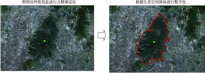
整合各类信息并建立Excel数据库,且合并一地多牌的生态游憩空间,面积和等级数据分别取相应类别中的较高者,最终得到539条生态游憩空间记录。采用点定位和目视解译相结合的方法,对生态游憩空间进行矢量化。首先,搜集各生态游憩点的经纬度信息,并将其导入到ArcGIS 10.0形成点集矢量图层,然后结合谷歌影像图与点的位置,对点周围的生态斑块进行数字化,得到面状的生态游憩空间。解译过程详见图1。
图1 广州白云山旅游区目视解译过程示意
Fig.1 Visual interpretation process of tourist scenic spots of the Baiyun Mountain
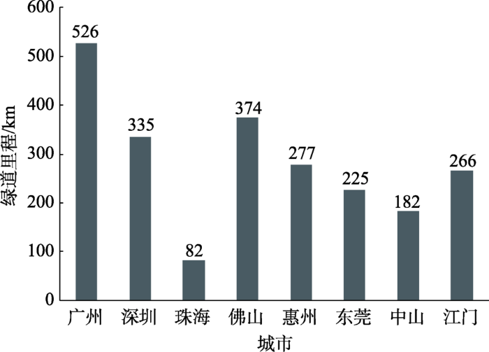
区域(省立)绿道网矢量图层基于广东省旅游局编制的珠三角绿道旅游地图数字化得来,共包括6条区域绿道,构成珠三角城市群的绿道骨干网络。其中广州市、佛山市和深圳市拥有的区域绿道里程较长,均在300 km以上;惠州市、东莞市和江门市的区域绿道里程也在200 km以上;中山市、珠海市的区域绿道里程较小,分别只有182、82 km(图2)。
图2 各城市区域绿道里程
注:数据来源于高长征等(2011)。
Fig.2 Total length of regional greenways in each city
绿道和生态游憩空间的连接关系属于典型的地理网络,对其分析一般采用拓扑结构测度、ArcGIS网络分析、社会网络分析等方法,本文综合运用这3种方法进行分析。
1.3.1 生态游憩网络的拓扑结构评估
首先定义一个“生态游憩空间—区域绿道”拓扑结构网络N(V, L)(以下简称生态游憩网络),其中V为节点集,即539个生态游憩空间,L为边,即两点之间的绿道,边都是简单连通的,不包含环和多重边,结合珠三角区域绿道旅游地图和生态游憩空间分布图手动绘制。然后,借鉴经济地理学的α、β、γ指数来测评N(V, L)的网络连通性。这3个指数常用于评价道路网的连通性(高洁, 2010),适用于本研究的情境。
其中,α指数可以测度生态游憩网络出现回路的可能性,其表达式为(Cook, 2002):
α指网络的总体环通度,为网络实际回路数与可能存在的最大回路数之比;L为连接线数;V为网络中的实际节点数。α的取值一般在0~1之间,但当孤点较多,连接线较少时,也可能存在小于0的情况,此时仍然取0,表示网络中没有回路。α越接近1,说明存在的回路越多。
β指数又称线点率,表示每个节点所邻接的边的平均数目,度量了节点与其他节点联系的难易程度,其计算公式为:
β的取值范围在0~3之间。当β=0时,代表节点之间无连接线;当0<β<1时,形成树状网络;当β=1时,构成单一回路的网络;当1<β≤3时,构成复杂网络。
γ指数为网络的总体连接度指标,其计算公式为:
γ的取值范围同样介于0~1之间,当其值为0时,表示网络内没有连线;当γ=1时,表示所有节点相互连接(高洁, 2010)。
1.3.2 生态游憩网络的集群结构评估
绿道连接会对生态游憩空间产生组群效应,形成大小不一的组团。为揭示这种集群式结构,借鉴Linehan等(1995)的做法,采用引力模型得出所有节点两两之间的互动程度。一般而言,节点的规模(或其他质量属性)越大,节点间的距离越短,节点的互动倾向越强,分离趋势越小。因而,引力模型可以反映生态游憩空间的连接度(Linehan et al, 1995)。其计算公式为:
式中:Gab指节点a与b之间的互动程度;Dab为两点之间的绿道连线距离,采用ArcGIS 10.0网络分析中的OD成本矩阵方法测算得出;Na、Nb分别指节点a和b的权重,这里指每个节点的生态游憩服务供给水平,为生态游憩空间等级和面积的综合值。设定省级(或4A级)生态游憩空间的质量权重为1,则县级(或2A级)、地市级(或3A级)与国家级(或5A级)的权重分别为0.333、0.667、1.333(表2),将面积乘以质量权重值就可以得出N值。
表2 各等级生态游憩空间的权重
Tab.2 Weights of ecological recreation spaces at all levels
| 序号 | 景区等级 | 其他生态游憩空间等级 | 权重值 | 游憩服务供给水平 |
|---|---|---|---|---|
| 1 | AA | 县级 | 0.333 | 低 |
| 2 | AAA | 市级 | 0.667 | 中 |
| 3 | AAAA | 省级 | 1 | 高 |
| 4 | AAAAA | 国家级 | 1.333 | 最高 |
以Gab值为指标,采用社会网络分析(Social Network Analysis)中的凝聚子群分析(Cohesive subgroup analysis)揭示生态游憩网络的集群结构。凝聚子群是指在社会关系网络中具有相对较强的、直接、紧密或者经常的和积极关系的一组行动者集合,它可以建立在互惠关系的基础上,也可以建立在可达性、联系频次或关系密度的基础上(Wasserman et al, 1994; 刘军, 2009)。在本文中,凝聚子群反映了绿道连接的生态游憩空间的小团体集聚现象,这种子群结构不完全由空间距离决定,还与生态游憩空间的服务水平成正比,因此也可能存在个别子群内部板块在空间上不连续的现象。凝聚子群密度表征了连接度的大小
具体操作时,首先建立以Gab值为指标的N×N的对称矩阵(表3),将矩阵导入UNINET 6.212,再运用CONCOR算法揭示生态游憩网络的凝聚子群。CONCOR算法是一种迭代相关收敛法,它首先计算出矩阵各行(或各列)的相关系数,然后进一步计算相关系数矩阵各行(或各列)的相关系数,经多次迭代运算后,矩阵的相关系数值由-1和1组成,对-1和1进行重新排列,就得出了绿道连接的生态游憩空间的凝聚子群分组结果(刘军, 2009)。
表3 由Gab值建立的对称矩阵
Tab.3 Symmetric matrix based on the values of Gab
| 珠海尖峰山 森林公园 | 肇庆星湖 风景名胜区 | 深圳梧桐山 国家森林公园 | 深圳大鹏半岛 国家地质公园 | 广州海珠湖 国家湿地公园 | 江门圭峰山 国家森林公园 | 东莞松山 湖景区 | …… | |
|---|---|---|---|---|---|---|---|---|
| 珠海尖峰山森林公园 | 0 | |||||||
| 肇庆星湖风景名胜区 | 7.830 | 0 | ||||||
| 深圳梧桐山国家森林公园 | 0.946 | 23.042 | 0 | |||||
| 深圳大鹏半岛国家地质公园 | 14.886 | 337.646 | 3205.033 | 0 | ||||
| 广州海珠湖国家湿地公园 | 10.115 | 305.019 | 17.638 | 240.441 | 0 | |||
| 江门圭峰山国家森林公园 | 24.799 | 571.241 | 32.56 | 494.311 | 517.999 | 0 | ||
| 东莞松山湖景区 | 10.142 | 266.339 | 1411.108 | 7039.627 | 221.418 | 362.243 | 0 | |
| …… |
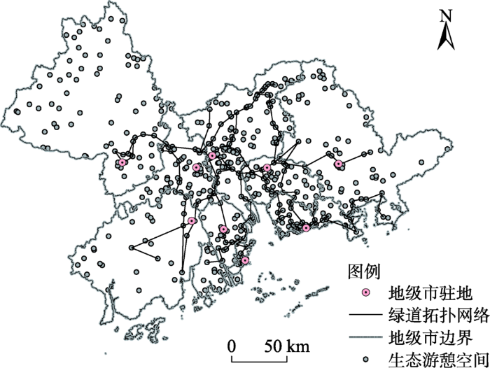
由绿道连接的拓扑网络(图3)统计出连接数(L)为208,共贯通198个节点(V),占生态游憩空间总数的36.7%,连通面积为20.84万hm2,占总面积的39.4%,表明仍有大部分区域性生态游憩空间孤立于省立绿道网络之外,特别是城市群边缘区孤立的点较多。根据式(1)—(3)计算出α指数为0,说明绿道网络的回路数趋近0。同样,可计算出β值为0.386,γ指数等于0.129。α、β、γ指数均较小,说明珠三角城市群已经形成的生态游憩空间网络为树状网络,孤点数多,环通性较差,总体连接度较低。
图3 珠三角城市群区域绿道连接的拓扑网络
Fig.3 Topological network connected by greenways in the Pearl River Delta region
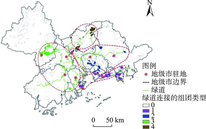
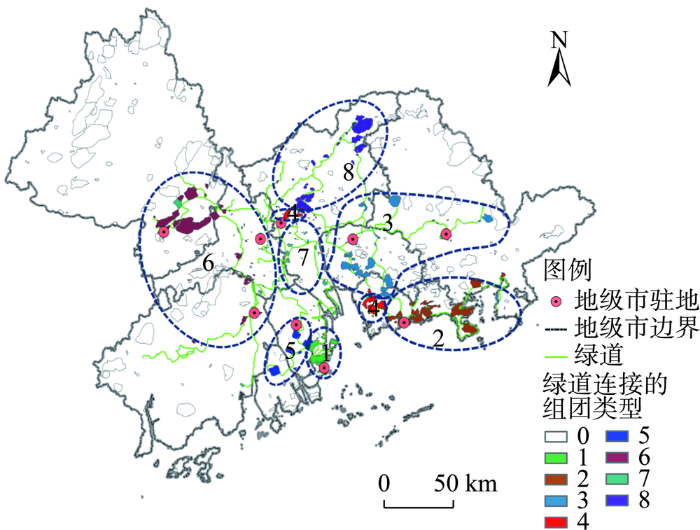
使用ArcGIS网络分析方法,以绿道为连接线,以生态游憩空间为节点,建立OD成本矩阵,得出节点间的最短绿道长度,在此基础上根据式(4)计算得出Gab值,再利用CONCOR算法得出生态游憩空间集群的第3个层面有8个凝聚子群,在第2个层面又进一步将8个子群归纳成4个子群。将子群编号作为属性赋值给生态游憩空间,并进行空间制图分析。
图4显示的是第2个层面的4个子群分区结果,根据其分布位置和范围可以将其命名为:① 珠三角南部组团;② 珠三角东部组团;③ 珠三角西部组团;④ 珠三角北部组团。说明绿道连接效应使珠三角城市群生态游憩空间分布形成四大联系相对紧密的片区。
图4 第2个层面的4个子群的空间分布
注:0表示绿道未连接的生态游憩空间。
Fig.4 Spatial distribution of the four subgroups at Level 2
图5显示的是第3个层面的8个凝聚子群:① 珠海市东部集群;② 深圳市东部—惠州市南部集群;③ 东莞市—深圳市北部—惠州市西部集群;④ 深圳市西部和广州市中部集群;⑤ 珠海市西部—中山市南部集群;⑥ 肇庆市市辖区—佛山市—江门市东北部集群;⑦ 广州市南部集群;⑧ 广州市北部集群。8个组团中,除了组团④ 由空间不邻近的两部分组成外,其余的都具有空间集聚性。
图5 第3个层面的8个凝聚子群的分布
注:0表示绿道未连接的生态游憩空间。
Fig.5 Spatial distribution of the eight cohesive subgroups at Level 3
由凝聚密度表(表4)对角线上数据可知,在8个子群中,第1、2、6子群内部生态游憩空间的面积较大,分布集中,因而密度值远高于其他子群。第4、8子群内部成员面积也较大,但由于空间分布较分散,因此密度值处于中等水平。子群3内部的生态游憩空间分布更分散,子群5的生态游憩空间数量较少,而子群7内的生态游憩空间面积小,生态游憩服务的供给水平较低,因而东莞市-深圳市北部-惠州市西部集群、珠海市西部-中山市南部集群、广州市南部集群的密度值都偏低。
表4 珠三角城市群生态游憩网络的凝聚子群密度
Tab.4 Cohesive subgroup density of the ecological recreation network of the Pearl River Delta urban agglomeration
| 名称 | 子群① | 子群② | 子群③ | 子群④ | 子群⑤ | 子群⑥ | 子群⑦ | 子群⑧ |
|---|---|---|---|---|---|---|---|---|
| ① 珠海市东部集群 | 25701.94 | |||||||
| ② 深圳市东部-惠州市南部集群 | 46.94 | 6721995.50 | ||||||
| ③ 东莞市-深圳市北部-惠州市西部集群 | 3266.27 | 79.88 | 984.72 | |||||
| ④ 深圳市西部和广州市中部集群 | 37997.99 | 108.19 | 82.71 | 3310.63 | ||||
| ⑤ 珠海市西部-中山市南部集群 | 1.49 | 2.02 | 3.97 | 2.14 | 681.82 | |||
| ⑥ 肇庆市辖区-佛山市-江门市东北部集群 | 6.62 | 4.73 | 10.19 | 5.97 | 5.90 | 118111.57 | ||
| ⑦ 广州市南部集群 | 1.85 | 0.95 | 2.33 | 1.57 | 9.25 | 5.44 | 56.26 | |
| ⑧ 广州市北部集群 | 213.55 | 21.29 | 118.49 | 956.53 | 6.72 | 20.33 | 6.18 | 9250.32 |
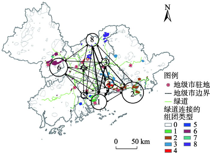
根据表4中子群之间密度值制作图6,进一步发现子群1、3、4和8之间的连接度高,子群2、3、4和8之间的连接度也相对较高。除子群1分布在珠江河口西岸(但紧邻东岸子群)之外,其他的子群都分布在珠三角河口的东岸和北部,说明珠三角东部和北部的广州、东莞、深圳、惠州以及珠海市东部5个区域的生态游憩空间的连接度较好,这不仅是由于它们之间绿道网络相对完善,也由于该范围内生态空间的游憩利用率较高。
图6 各凝聚子群间连接关系图示
注:本图根据
Fig.6 Illustration of the connections between the cohesive subgroups
然而,子群1和5尽管空间邻近,但是彼此之间的子群密度值仅为1.49,说明二者的连接度不高,这是因为2个子群之间缺少绿道连接,导致二者彼此孤立。子群7位于与子群3、5、6、8联系的关键位置,但与周边子群的密度值均低于10,说明其与周边子群的空间联系不高,未能起到应有的纽带作用。此外,子群5、6、7与外部子群之间的密度值普遍偏低,表明这3个子群相对孤立。从这些子群分布的位置可以判断出珠三角城市群西南部的佛山市、珠海市、中山市、江门市和西北部的肇庆市之间连接度不高,且西南部子群、西北部子群与北部、东部子群之间的连接度也较低,说明生态游憩空间连接的空间分割性比较明显。
2.2.1 绿道政策与布局
由于珠三角区域绿道目前主要分布在市辖区,因此,城市群核心地区生态游憩空间成为了一个整体,连接度较高,郊区市县绝大多数生态游憩空间尽管规模相对较大,如肇庆市的西北部地区、江门市的西部地区等,却未能被纳入城市群生态开放空间网络,导致绿道连接的生态游憩空间规模偏低,说明现阶段区域绿道政策的取向是以建设都市绿道、优化连片建成区生态系统和人居环境为主,生态绿道、郊野绿道建设力度不强。此外,珠三角绿道布局还具有2个明显特征:其一,珠三角东部和北部的广州、东莞、深圳、惠州四市间绿道网络相对完善,区域绿道长度占总长度的57.5%,因而生态游憩空间的连接度较好;其二,广州-东莞-深圳与广州-中山-珠海作为珠三角区域发展的2条主轴,各分布有2条绿道干线,数量上高于其他地区,这使得广州至珠海方向、广州至深圳方向的连接度较高。
2.2.2 绿道建设机制
由图2可发现各市绿道长度存在较大的差异。绿道发展是珠三角区域自上而下发起的,但为减少省政府的财政负担,绿道建设采用的是自下而上的机制,省级管理部门负责规划和业务指导,各城市分别成立了市级绿道领导小组,将建设任务分解至县区(或镇),建设资金由市级政府或县区(镇)政府负担,也有的由两级政府共同分担(刘铮,2017)。总体而言,地方政府(市、县区与镇政府)自主负担绿道建设与维护所需资金,但因为地方财政实力与政府竞争意识不一,如广州市黄埔区主动要求建设40 km省立绿道(广州市林业和园林局, 2010),导致绿道建设水平出现差异,最终使得广州、深圳、佛山等市的区域绿道实际建设里程较长,连接度也相对较高,而西部、西北地区成为绿道建设的短板。
2.2.3 生态游憩空间规模的集聚格局
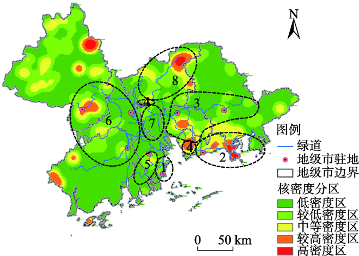
以面积为属性,对生态游憩空间分布图进行核密度分析(图7),发现生态游憩空间规模主要集聚在深圳东部、深圳西部、东莞中南部、广州北部、肇庆西南部、肇庆东北部、江门西部7个区域。根据表4可知,珠海市东部集群(第1子群)、深圳市东部-惠州市南部集群(第2子群)、肇庆市市辖区-佛山市-江门市东北部集群(第6子群)与广州市北部集群(第8子群)内部连接度较高,而这四大区域中恰存在较大的生态游憩空间面积集聚区,特别是第2子群的集聚态势最明显。也就是说,绿道在贯通生态游憩空间面积集聚区时更可能会产生连接度较高的子群。广州市南部集群(第7子群)内部缺少生态游憩空间分布,因而内部绿道虽然较长,但连接度反而最低。当然,东莞市-深圳市北部-惠州市西部集群(第3集群)也包含了东莞市中南部集聚区,但该区与所属子群西部的惠州市中部生态游憩空间集聚区距离较远,生态游憩空间分布分散,因而子群内部连接度较低。
图7 2017年生态游憩空间规模分布的核密度
Fig.7 Nuclear density map of the scale of ecological recreation space in 2017
2.2.4 地理阻隔与空间邻近性
珠江河口对东西两岸的阻隔是绿道连接的障碍,在其影响下,除南部的第4组团外,总体上形成东、西、北等分割性比较明显的组团式分布模式(图4)。在大的组团框架下,各凝聚子群间的连接度也明显受到空间邻近性的影响。例如,广州、东莞、深圳、惠州四市及珠海东部地域邻近,因而该范围内生态游憩空间凝聚子群间的密度较高,而西侧的珠海市西部-中山市南部集群(第5子群)、肇庆市辖区-佛山市-江门市东北部集群(第6子群)与北部、东部子群之间的空间距离较远,因而子群之间连接度也较低。
(1) 本文定义了一个“生态游憩空间—区域绿道”拓扑网,构建了连接度定量评价的模型。“生态游憩空间—区域绿道”拓扑网的构想源自道路拓扑网,但与之不同的是,生态游憩网络中节点不具备枢纽功能,因而节点的瘫痪对整体连接度的负效应要低于道路网(高洁, 2010)。评价模型的测算结果主要反映了连接度的整体水平和空间分布特征,在方法应用上有一定的创新,但模型也具有一定的局限性。首先,本文表达的连接度,实际上是一种基于绿道连接线的生态游憩空间综合功能间的潜在联系度,侧重从景观形态与结构方面考察,并不是基于实际生态流、人流的各细分功能的联系。其次,模型对网络中边和节点的结构性特征缺少揭示。实际上,即使2个网络的边和节点数量相等,也会因为边连接方向不同导致总体连接度的差异。最后,本文所用模型没能反映区域社会经济要素和生态游憩空间连接度的关系。
(2) 本文采用α、β、γ指数评价了网络的回路数、线点率和环通度,发现珠三角城市群生态游憩网络为树状型,节点数量、节点规模和回路数的值较低,空间连接度整体不高。据测算,绿道连接的节点数量和面积不超过40%,仍有60%以上的生态游憩空间没有被纳入网络。由于珠三角区域绿道规划和政策是以建成区优先,然后再向郊区的乡村拓展,因而郊区市县绝大多数生态游憩空间尽管规模相对较大,但未被接入绿道网,拉低了整体的连接度。而城市群核心地区现有绿道网络也因为环线和连接道较少,所以环通度较差、总体连接度较低。与道路网类似(徐军等, 2000),α、β、γ指数值主要体现了生态游憩网络中边的数量多少,但难以反映网络在结构和形态方面的特性。
(3) “生态游憩空间-区域绿道”网络呈集群式分布,各集群连接度存在明显的区域分异。绿道分布和生态游憩空间规模集聚的双重效应使珠三角城市群形成了8 个凝聚子群,且边缘地区子群(包括第1、2、6、8 子群)的连接度要高于中心地区子群的密度。这一结论与大都市区绿地的可达性格局(Dai,2011)以及珠三角城市群生态游憩空间可达性格局类似(Wang et al, 2018),但与工业化和城镇化格局恰好相反,这是由于中心地区人口、产业与城镇等要素高度集聚,占用了较多的生态空间(叶玉瑶,2006;丁俊等, 2016),而边缘山区和海滨地区还保留有规模较大的生态游憩空间,表明了城镇化进程中生态景观可持续发展和建设用地扩张的矛盾,同时也凸显了通过区域绿道整合城市群中心区和边缘区生态游憩空间的必要性。
(4) 生态游憩空间集群之间的空间联系呈现出东部-北部大于西部、东西部之间空间分割性比较明显的格局。具体而言,珠三角东部-北部的广州、东莞、深圳、惠州以及珠海市东部5 个区域内的第1、2、3、4、8 子群之间连接度相对较高,而珠三角城市群西南部子群、西北部子群与东部-北部子群之间的连接度较低,空间分割性比较明显。这与陈浩等(2011)得出的珠三角城市群旅游流联系、陈伟劲等(2013)发现的城市联系的网络结构以及区域发展轴线布局类似,即由深圳、广州和珠海市构成的三角形区域旅游流联系较密切,并显著大于其他区域。原因在于3 个方面:一是因为绿道布局与旅游流、城市联系和区域规划的空间轴线分布类似;其二,生态游憩空间规模分布不平衡,广州、深圳、东莞城市经济发展和城镇化水平高,生态游憩空间建设力度更大,集聚水平要大于西部地区(图7);其三,东部-北部之间的子群分布邻近,而与西部子群则距离相对较远,且受珠江河口阻隔。这说明各地市绿道建设和生态空间游憩利用各自为阵,协作力度不够,而区域所做的统筹协调工作也不够。
优化“生态游憩空间-区域绿道”网络是完善区域生态开放空间系统的基本路径,具有重要的战略意义。研究结论启示未来城市群要以网络化思维整合城区和郊区“生态游憩空间-绿道”系统,优化绿道连接的拓扑结构,形成完善的区域生态游憩网络。
3.2.1 推进城市群边缘区生态游憩空间的绿道连接
充分借鉴欧美国家绿道建设的经验,实现绿道与生态游憩空间的穿点连线、集结成网、互联互通。如美国绿道建设注重利用绿道连接郊区的郊野公园、区域公园、国家公园以及其他自然保留地,形成一个相互连通的生态游憩空间网络,既增加了开敞空间,也促进了生态系统的完整性保护。珠三角城市群边缘区的不少生态游憩空间是未被绿道连接的“孤岛”,不利于从整体上提升生态系统服务。建议城市群对河流、山谷等生态廊道以及交通线两侧生态环境进行整治和修复,开辟绿道开敞空间,将绿道网向城市群边缘区延伸,同时增设郊区绿道环线,将全域主要生态游憩空间连接起来,完善生态网络,控制城市蔓延,也有助于增加居民的郊野游憩机会,带动城郊旅游业发展,深入推进城乡一体化。
3.2.2 完善城市群现有绿道连接网络
绿道连接的生态游憩空间拓扑网络的α、β、γ指数较小,说明网络的连接度不高,环通性差,且除了少数几个凝聚子群与其他子群间密度较高外,大部分子群之间的密度偏低,说明它们之间的空间联系不强。下一步需要完善区域绿道网来优化生态游憩网络,其中一项重要工作是加强区域绿道环线建设,优化内部衔接,提升城市群生态游憩空间的连续性和互通性。例如,如果在凝聚子群1和子群5之间有绿道连接,二者有望成一个整体,而不再是2个分割的子群;此外,大部分区域绿道为“断头路”,可以因地制宜地建设环线连接绿道末端,构成环线型生态廊道,增加环通度。
3.2.3 加强生态空间修复与游憩利用
研究结果显示:大部分子群密度值较低,与其内部生态游憩空间节点数、节点规模和等级状况有关。要提升子群连接度,首先需要依据生态适宜性进一步促进城市群现有生态空间的游憩利用,增加连接的节点数;其次,利用生态修复扩展生态游憩空间数量和规模。例如,广州市南部集群(第7子群)属于建成区,生态游憩空间稀缺(图7),应通过城市更新、人口疏散以及生态修复等综合治理手段,增加生态游憩空间供给,充分彰显其枢纽型节点的作用;最后,通过提升生态游憩空间节点的生态景观与游憩服务质量,提升节点等级,从而加强节点之间互动强度。
3.2.4 建立绿道建设和生态空间游憩利用的区域统筹机制
自下而上的绿道建设和生态空间游憩开发运动,在短期内取得了一定的效果,但行政区间协调性不强,且可持续性较差。为此,珠三角城市群生态游憩空间与区域绿道的空间整合,应该实行自下而上和自上而下相结合的路径,加强顶层设计与统筹协调力度,加强区域一体化的制度和组织设计,在区域绿道和生态游憩空间顶层规划和建设时考虑行政区间的衔接和平衡。在项目建设机制上可以以地方建设为主,以区域性开发作为补充。例如,可以设立区域生态开放空间投资建设开发公司,吸收各地方政府、企业等作为投资主体,搭建生态游憩空间和绿道项目建设与经营的统一平台,统筹优化城市群生态景观的游憩化利用格局。
3.2.5 强化“生态游憩空间-区域绿道”规划与优化的科技支撑
需进一步加强“生态游憩空间-区域绿道”网络评估和规划的理论和技术方法研究,为绿道与生态游憩空间的科学布局与管理提供更有力的决策支持。本文虽就此进行了有益探究,但仍需突破的问题包括:① 珠三角城市群部分绿道段存在配套设施不完善、生态性不足、过于人工化与交通化等问题(胡卫华, 2013; 刘铮, 2017),后续研究需重视绿道设计、建设和管理中的微观问题,加强中观微观尺度绿道质量和功能评价与实证研究,为绿道设计和建设提供支撑;② 进一步加强方法和技术手段的创新,力争利用实际对流数据来考察生态游憩空间细分功能的连接度,刻画网络在结构上的特性;③ 引入社会经济要素,基于多要素间关系综合评价网络的文化服务功能,如考察人口对网络的可达性,调研居民对网络的感知、评价、使用行为以及网络对身心健康、社会融合等的效应,为网络的管理提供支撑。
The authors have declared that no competing interests exist.
| [1] |
|
| [2] |
德国城市群内区域公园规划管理手段研究: 以莱茵美茵区域公园为例 [J].
进入21世纪以来,城市群成为推动我国经济和城市化发展的重要地域空间形式。在城市群硬件环境跨越式发展的同时,区域的柔性空间建设不足、城乡景观破碎化发展、地方文化传承断裂等问题制约了区域整体竞争力的提升,迫切需要从理论及实践中构建适宜的框架和手段。近20年以来,区域公园作为德国新时期城市群内开放空间的一类管制工具,在改善城市群形象、提升区域综合价值、提供亲近自然的就近休憩场所、推动都市农业发展等方面扮演了越发重要的角色。本文以法兰克福—莱茵—美茵城市群内的莱茵美茵区域公园为例,详细分析城市群内区域公园的内涵特征、发展历程、管理模式以及存在的矛盾问题等内容。研究表明,弹性、灵活的规划定位,多元、包容的空间管理手段和以项目为主导的配套对策是促进城市群内区域公园不断发展的重要因素,对于国内城市群内部绿色开放空间管理具有借鉴意义。
Research on planning and management of regional parks in german metropolitan regions: A case study on Regional Park Rhein Main in Frankfurt/Rhein-Main metropolitan region .
进入21世纪以来,城市群成为推动我国经济和城市化发展的重要地域空间形式。在城市群硬件环境跨越式发展的同时,区域的柔性空间建设不足、城乡景观破碎化发展、地方文化传承断裂等问题制约了区域整体竞争力的提升,迫切需要从理论及实践中构建适宜的框架和手段。近20年以来,区域公园作为德国新时期城市群内开放空间的一类管制工具,在改善城市群形象、提升区域综合价值、提供亲近自然的就近休憩场所、推动都市农业发展等方面扮演了越发重要的角色。本文以法兰克福—莱茵—美茵城市群内的莱茵美茵区域公园为例,详细分析城市群内区域公园的内涵特征、发展历程、管理模式以及存在的矛盾问题等内容。研究表明,弹性、灵活的规划定位,多元、包容的空间管理手段和以项目为主导的配套对策是促进城市群内区域公园不断发展的重要因素,对于国内城市群内部绿色开放空间管理具有借鉴意义。
|
| [3] |
基于旅游流的城市群旅游地旅游空间网络结构分析: 以珠江三角洲城市群为例 [J].https://doi.org/10.11821/xb201102011 URL [本文引用: 2] 摘要
随着城市化进程的逐步推进,城市群逐渐成为旅游发展赖以依存的区域主体,也必将成为一种特殊尺度类型的旅游目的地。文章基于相关文献的分析,界定了城市群旅游地的概念。在对珠三角旅行社区内线路、区内长途客运、国内(省外)旅行社赴珠三角及港澳游客实际到达情况分析的基础上,运用网络理论和方法对珠三角城市群网络结构进行了定量研究。结果表明,广州的到达中心性、接近性、中间度数值均较高,也是国内(省外)游客到珠三角的集散地,在网络中处于中心地位;深圳、珠海由于毗邻香港和澳门,是珠三角城市群区域重要的目的地,同时也是港澳游客进入内地特别是珠三角的重要集散地。其他城市如佛山、东莞两城市以商务旅游为主,惠州、肇庆以生态旅游为特色,而中山、江门则两者兼具的特点。最后构建了珠三角城市群旅游地空间网络结构模式,形成"三级旅游基地、三类旅游区域、三条主要旅游轴线"的空间模式。
The spatial network structure of the tourism destinations in urban agglomerations based on tourist flow: A case study of the Pearl River Delta .https://doi.org/10.11821/xb201102011 URL [本文引用: 2] 摘要
随着城市化进程的逐步推进,城市群逐渐成为旅游发展赖以依存的区域主体,也必将成为一种特殊尺度类型的旅游目的地。文章基于相关文献的分析,界定了城市群旅游地的概念。在对珠三角旅行社区内线路、区内长途客运、国内(省外)旅行社赴珠三角及港澳游客实际到达情况分析的基础上,运用网络理论和方法对珠三角城市群网络结构进行了定量研究。结果表明,广州的到达中心性、接近性、中间度数值均较高,也是国内(省外)游客到珠三角的集散地,在网络中处于中心地位;深圳、珠海由于毗邻香港和澳门,是珠三角城市群区域重要的目的地,同时也是港澳游客进入内地特别是珠三角的重要集散地。其他城市如佛山、东莞两城市以商务旅游为主,惠州、肇庆以生态旅游为特色,而中山、江门则两者兼具的特点。最后构建了珠三角城市群旅游地空间网络结构模式,形成"三级旅游基地、三类旅游区域、三条主要旅游轴线"的空间模式。
|
| [4] |
城市绿地服务功能的居民认知度研究 [J].
城市绿地作为城市中公共场所和自然元素,担当着多种功能。而居民对城市绿地各种服务功能的认知度受到自身主观因素和所处绿地环境因素的影响。本文通过问卷对南京市居民绿地服务功能认知进行调查,从居民绿地服务功能重要性认知、服务功能感知两方面分析居民认知度及其影响因素。结果表明:居民对各服务功能的感知程度与其重要性认知结果大体一致,对绿地的生态环境功能感知度低于其主观重要性认知水平;居民自身主观因素中的年龄和文化程度、所处绿地数量和植物种类对居民的感知程度和重要性认知有显著影响。
A study on greenspace service cognition of urban residents in Nanjing China .
城市绿地作为城市中公共场所和自然元素,担当着多种功能。而居民对城市绿地各种服务功能的认知度受到自身主观因素和所处绿地环境因素的影响。本文通过问卷对南京市居民绿地服务功能认知进行调查,从居民绿地服务功能重要性认知、服务功能感知两方面分析居民认知度及其影响因素。结果表明:居民对各服务功能的感知程度与其重要性认知结果大体一致,对绿地的生态环境功能感知度低于其主观重要性认知水平;居民自身主观因素中的年龄和文化程度、所处绿地数量和植物种类对居民的感知程度和重要性认知有显著影响。
|
| [5] |
珠三角城市联系的空间格局特征研究: 基于城际客运交通流的分析 [J].
利用城际客运交通流,从城市和功能区两个尺度对珠三角城市之间功能联系的空间格局进行分析,结果表明:联系强度上呈现出中心与外围、东岸与西岸、三大次区域不均衡的空间分异特征,联系方向上呈现出总体指向广州和深圳、局部非连续化的空间组织特征,联系节点上呈现出梯度层级和多中心功能布局并存的空间结构特征。当前珠三角正处于经济结构转型升级、区域一体化政策趋势加强、区域交通基础设施快速兴建的阶段,这些因素会对区域内资源要素流的性质类型、空间配置和流动廊道产生深刻影响。
Characteristics of regional city connection's spatial pattern based on intercity passenger traffic flow in Pearl River Delta .
利用城际客运交通流,从城市和功能区两个尺度对珠三角城市之间功能联系的空间格局进行分析,结果表明:联系强度上呈现出中心与外围、东岸与西岸、三大次区域不均衡的空间分异特征,联系方向上呈现出总体指向广州和深圳、局部非连续化的空间组织特征,联系节点上呈现出梯度层级和多中心功能布局并存的空间结构特征。当前珠三角正处于经济结构转型升级、区域一体化政策趋势加强、区域交通基础设施快速兴建的阶段,这些因素会对区域内资源要素流的性质类型、空间配置和流动廊道产生深刻影响。
|
| [6] |
珠江三角洲城市群工业生产空间格局、形态特征及影响因素 [J].https://doi.org/10.18306/dlkxjz.2016.05.008 URL [本文引用: 1] 摘要
GIS空间分析技术为空间形态的精准判别提供了新的路径和研究视角。本文通过高分辨率Google Earth影像提取2013年珠江三角洲城市群的工业生产空间分布信息,运用分形模型、形态紧凑度、空间离散度、密度指数定量分析珠三角工业生产空间的形态特征,采用GIS空间分析并结合社会经济统计分析进一步探讨了影响其分布的主要因素。结果表明:①2013年珠江三角洲城市群的工业生产空间共有2604.71 km2,其空间分布呈现典型的“核心—边缘”结构,并且形成了交错式、零散式和集中式3种分布模式。②珠江三角洲城市群的工业生产空间具有很强的分形特征,核心区的分形维数整体小于外围地区,而空间结构的稳定性高于外围地区;珠三角各市中,工业生产空间形态紧凑度最高的为珠海、最低的为广州,而空间离散度最高的为惠州、最低的为中山;珠三角各市工业生产空间的规模差异显著,与经济规模、人口规模、工业企业数等呈较强的正相关关系,而东莞、深圳、中山、佛山的密度指数过高,需加强工业生产空间的集约高效利用。③自然因素与交通条件、城镇化与开发区的发展、政策的引导和调控以及经济全球化是珠江三角洲城市群工业生产空间分布的主要影响因素。
Spatial pattern and morphological characteristics of industrial production space and influential factors in the Pearl River Delta urban agglomeration .https://doi.org/10.18306/dlkxjz.2016.05.008 URL [本文引用: 1] 摘要
GIS空间分析技术为空间形态的精准判别提供了新的路径和研究视角。本文通过高分辨率Google Earth影像提取2013年珠江三角洲城市群的工业生产空间分布信息,运用分形模型、形态紧凑度、空间离散度、密度指数定量分析珠三角工业生产空间的形态特征,采用GIS空间分析并结合社会经济统计分析进一步探讨了影响其分布的主要因素。结果表明:①2013年珠江三角洲城市群的工业生产空间共有2604.71 km2,其空间分布呈现典型的“核心—边缘”结构,并且形成了交错式、零散式和集中式3种分布模式。②珠江三角洲城市群的工业生产空间具有很强的分形特征,核心区的分形维数整体小于外围地区,而空间结构的稳定性高于外围地区;珠三角各市中,工业生产空间形态紧凑度最高的为珠海、最低的为广州,而空间离散度最高的为惠州、最低的为中山;珠三角各市工业生产空间的规模差异显著,与经济规模、人口规模、工业企业数等呈较强的正相关关系,而东莞、深圳、中山、佛山的密度指数过高,需加强工业生产空间的集约高效利用。③自然因素与交通条件、城镇化与开发区的发展、政策的引导和调控以及经济全球化是珠江三角洲城市群工业生产空间分布的主要影响因素。
|
| [7] |
功在当下造福千秋: 珠三角绿道网建设的调查报告 [J].https://doi.org/10.3969/j.issn.1006-3862.2012.02.001 URL [本文引用: 1] 摘要
广东于2010年1月开始建设珠三角绿道网,效果初显,深受民众欢迎。许多省市也开始规划建设绿道网。通过实地考察、调查,试图回答什么是绿道、广东为什么要下大力气抓绿道网、是怎么做的、有什么成效经验和启示,以期给各地提供参考。
Investigating on the Pearl River Delta greenway network .https://doi.org/10.3969/j.issn.1006-3862.2012.02.001 URL [本文引用: 1] 摘要
广东于2010年1月开始建设珠三角绿道网,效果初显,深受民众欢迎。许多省市也开始规划建设绿道网。通过实地考察、调查,试图回答什么是绿道、广东为什么要下大力气抓绿道网、是怎么做的、有什么成效经验和启示,以期给各地提供参考。
|
| [8] |
佛山市城市生态控制线划定规划 [EB/OL]. (2017-Planning of urban ecological control line in Foshan City . (2017-06-20)[2018-04-04]. . ] |
| [9] |
景观生态学中生态连接度研究进展 [J].https://doi.org/10.3321/j.issn:1000-0933.2009.11.052 URL Magsci [本文引用: 1] 摘要
生态连接度对生物迁移扩散、基因流动、干扰扩散等生态过程具有重要作用,是目前景观生态学研究的热点内容。生态连接度是测度景观对于资源斑块间运动的促进或者阻碍作用程度的指标。它主要基于渗透和图论两大理论,通过实验、模型模拟以及指数等量化方法描述区域景观结构和功能的变化,广泛应用在自然景观和城市景观格局优化中,对生物多样性保护以及城市开放空间规划具有重要作用。介绍生态连接度的理论基础、评价方法,应用以及主要结论,并对景观生态学中生态连接度的未来研究方向进行展望,以促进生态连接度研究的进一步发展。
A review on ecological connectivity in landscape ecology .https://doi.org/10.3321/j.issn:1000-0933.2009.11.052 URL Magsci [本文引用: 1] 摘要
生态连接度对生物迁移扩散、基因流动、干扰扩散等生态过程具有重要作用,是目前景观生态学研究的热点内容。生态连接度是测度景观对于资源斑块间运动的促进或者阻碍作用程度的指标。它主要基于渗透和图论两大理论,通过实验、模型模拟以及指数等量化方法描述区域景观结构和功能的变化,广泛应用在自然景观和城市景观格局优化中,对生物多样性保护以及城市开放空间规划具有重要作用。介绍生态连接度的理论基础、评价方法,应用以及主要结论,并对景观生态学中生态连接度的未来研究方向进行展望,以促进生态连接度研究的进一步发展。
|
| [10] |
珠三角区域绿道建设与管理问题研究 [J].https://doi.org/10.3969/j.issn.1006-0022.2011.z1.032 URL [本文引用: 1] 摘要
珠三角在工业化快速发展进程中 出现了城市无序蔓延、生态环境破坏严重、城市可使用绿地不多等诸多问题。为改善人居环境,维护生态安全,2010年初广东省启动了珠三角区域绿道建设, 在"一年基本建成"的任务目标完成后,针对一年多以来珠三角绿道在设计、建设和管理等方面出现的问题,借鉴美国绿道建设的经验,提出"分类分期,实现优质 建设;生态优先,提高绿化质量;完善配套,加强安全管理;政府主导,提出社会共建"四条建议,为绿道建设与管理提供借鉴。
Greenbell construct and management of Pearl River Delta .https://doi.org/10.3969/j.issn.1006-0022.2011.z1.032 URL [本文引用: 1] 摘要
珠三角在工业化快速发展进程中 出现了城市无序蔓延、生态环境破坏严重、城市可使用绿地不多等诸多问题。为改善人居环境,维护生态安全,2010年初广东省启动了珠三角区域绿道建设, 在"一年基本建成"的任务目标完成后,针对一年多以来珠三角绿道在设计、建设和管理等方面出现的问题,借鉴美国绿道建设的经验,提出"分类分期,实现优质 建设;生态优先,提高绿化质量;完善配套,加强安全管理;政府主导,提出社会共建"四条建议,为绿道建设与管理提供借鉴。
|
| [11] |
交通运输网络连通性评价指标分析 [J].https://doi.org/10.3969/j.issn.1672-4747.2010.01.007 URL [本文引用: 3] 摘要
交通运输网络是由节点与边所组成的有机体。为更全面的评价网络的连通性能,不仅需要分析边的数量及位置对连通性的影响,而且需要分析节点对网络连通性的影响。在分析现有交通运输网络连通性指标的基础上,本文提出了拓朴结构连通性评价指标,采用不相邻节点对节点-连通度的平均值衡量网络的连通性,并通过算例做了几种连通性评价指标的有效性对比。
Analysis of transportation network connectivity evaluation index .https://doi.org/10.3969/j.issn.1672-4747.2010.01.007 URL [本文引用: 3] 摘要
交通运输网络是由节点与边所组成的有机体。为更全面的评价网络的连通性能,不仅需要分析边的数量及位置对连通性的影响,而且需要分析节点对网络连通性的影响。在分析现有交通运输网络连通性指标的基础上,本文提出了拓朴结构连通性评价指标,采用不相邻节点对节点-连通度的平均值衡量网络的连通性,并通过算例做了几种连通性评价指标的有效性对比。
|
| [12] |
广东省A级旅游景区名录(截至2017年9月8日) [EB/OL]. (2017-A list of grade-A scenic spots in Guangdong Province (up to September 8, 2017) . (2017-10-30)[2018-01-01]. . ] |
| [13] |
珠江三角洲绿道网总体规划纲要 [J].
1绿道与绿道网1.1绿道绿道(Greenway)是一种线形绿色开敞空间,通常沿着河滨、溪谷、山脊、风景道路等自然和人工廊道建立,内设可供行人和骑车者进入的景观游憩线路,连接主要的公园、自然保护区、风景名胜区、历史古迹和城乡居住区等,有利于更好地保护和利用自然、历史文化资源,并为居民提供充足的游憩和交往空间(详见专栏1)。
Green Pearl River Delta road network master plan outline .
1绿道与绿道网1.1绿道绿道(Greenway)是一种线形绿色开敞空间,通常沿着河滨、溪谷、山脊、风景道路等自然和人工廊道建立,内设可供行人和骑车者进入的景观游憩线路,连接主要的公园、自然保护区、风景名胜区、历史古迹和城乡居住区等,有利于更好地保护和利用自然、历史文化资源,并为居民提供充足的游憩和交往空间(详见专栏1)。
|
| [14] |
广州市绿道网建设第四次现场会议 [R].The fourth on-site meeting of Guangzhou greenway network construction . |
| [15] |
绿道旅游存在的问题及开发对策: 以珠三角绿道网为例 [J].
以国内最大的区域绿道建设工程珠三角绿道网为研究对象,基于对深圳、广州、东莞、惠州、中山五市的绿道和香港郊野公园的实地调研,分析了其对区域旅游发展的影响和建设中存在的重速度、轻质量,重建设、轻管理,重游道、轻配套,重形式、轻内涵等问题。针对上述问题,提出了布局网络化、建设生态化、特色多样化、设施人性化、管理科学化和活动多元化的解决对策,以达到绿道旅游效益的最大化。
Problems of greenway tourism and countermeasures: A case study of PRD .
以国内最大的区域绿道建设工程珠三角绿道网为研究对象,基于对深圳、广州、东莞、惠州、中山五市的绿道和香港郊野公园的实地调研,分析了其对区域旅游发展的影响和建设中存在的重速度、轻质量,重建设、轻管理,重游道、轻配套,重形式、轻内涵等问题。针对上述问题,提出了布局网络化、建设生态化、特色多样化、设施人性化、管理科学化和活动多元化的解决对策,以达到绿道旅游效益的最大化。
|
| [16] |
城市生态游憩空间服务功能评价与优化对策 [J].https://doi.org/10.11819/cpr20150809a URL [本文引用: 1] 摘要
以城市公园和绿地为主的城市生态游憩空间作为城市的生态基础设施,其空间的格局与功能的水平是体现城市宜居性的重要因素。本研究以上海为对象,在综合城市总体数量特征指标的同时,将考虑城市居民对城市生态空间的游憩需求和空间格局的特征,以体现可达性、人均占有量、功能完整性、城市空间和游憩满意度等为目标,选择更能反映城市生态游憩空间服务功能水平的综合指标构建评价体系,并进行评价;结果发现目前上海综合评分处于较低的状态,其主要原因不是其绝对的空间数量值低,而是空间格局不合理而造成的功能受损。据此,从定位、目标的角度提出优化服务功能的对策。
Evaluation and optimization countermeasures for service functions of urban ecological recreation space .https://doi.org/10.11819/cpr20150809a URL [本文引用: 1] 摘要
以城市公园和绿地为主的城市生态游憩空间作为城市的生态基础设施,其空间的格局与功能的水平是体现城市宜居性的重要因素。本研究以上海为对象,在综合城市总体数量特征指标的同时,将考虑城市居民对城市生态空间的游憩需求和空间格局的特征,以体现可达性、人均占有量、功能完整性、城市空间和游憩满意度等为目标,选择更能反映城市生态游憩空间服务功能水平的综合指标构建评价体系,并进行评价;结果发现目前上海综合评分处于较低的状态,其主要原因不是其绝对的空间数量值低,而是空间格局不合理而造成的功能受损。据此,从定位、目标的角度提出优化服务功能的对策。
|
| [17] |
北京市绿带游憩空间分布特征及其成因 [J].https://doi.org/10.11821/dlyj201508009 URL [本文引用: 1] 摘要
绿带是阻止城市蔓延、提高城市生态安全格局的重要手段,其游憩开发能够为大都市游憩空间紧缺提供有效的解决途径。以北京市第二道绿带为研究区,以2013年绿带内6种类型游憩空间(共448处)为研究对象,运用Kernel核密度算法等空间分析方法,从北京市绿带游憩空间的整体分布格局、规模容量特征和各类型游憩空间分布特征及成因三个层面进行分析。主要结论:1从整体分布格局来看,北京市绿带内形成了若干游憩空间集聚区域,游憩空间结构出现"北密南疏"的整体特征;北部游憩空间集聚程度高且分布连续成带,南部游憩空间集聚程度较低且分布离散成团;北部温榆河沿岸地区游憩空间大量集聚,成为绿带游憩空间结构的主要骨架。2从规模容量特征来看,占地规模较大的游憩空间呈集聚分布,规模较小的游憩空间呈分散分布,绿带内已形成了6个由面积规模较大的游憩空间密集分布构成的热点区。3绿带内6种类型游憩空间分布特征及成因表现为:绿带内的资源环境本底决定了既有吸引物游憩空间的空间特征;政策性规划引导郊野休闲公园空间分布相对均匀;重要水系与运动健身游憩空间的空间分布高度关联;主题活动游憩空间更倾向于靠近主要交通干道;会议度假游憩空间与北京市地热资源分布契合度高;民俗体验游憩空间大量分布在海淀区上庄水库周边。揭示了北京市绿带游憩空间布局情况,为中国绿带游憩体系的统筹建设、空间结构调整和布局优化提供了参考。
Spatial characteristics and causes of recreational space in the urban green belt of Beijing, China .https://doi.org/10.11821/dlyj201508009 URL [本文引用: 1] 摘要
绿带是阻止城市蔓延、提高城市生态安全格局的重要手段,其游憩开发能够为大都市游憩空间紧缺提供有效的解决途径。以北京市第二道绿带为研究区,以2013年绿带内6种类型游憩空间(共448处)为研究对象,运用Kernel核密度算法等空间分析方法,从北京市绿带游憩空间的整体分布格局、规模容量特征和各类型游憩空间分布特征及成因三个层面进行分析。主要结论:1从整体分布格局来看,北京市绿带内形成了若干游憩空间集聚区域,游憩空间结构出现"北密南疏"的整体特征;北部游憩空间集聚程度高且分布连续成带,南部游憩空间集聚程度较低且分布离散成团;北部温榆河沿岸地区游憩空间大量集聚,成为绿带游憩空间结构的主要骨架。2从规模容量特征来看,占地规模较大的游憩空间呈集聚分布,规模较小的游憩空间呈分散分布,绿带内已形成了6个由面积规模较大的游憩空间密集分布构成的热点区。3绿带内6种类型游憩空间分布特征及成因表现为:绿带内的资源环境本底决定了既有吸引物游憩空间的空间特征;政策性规划引导郊野休闲公园空间分布相对均匀;重要水系与运动健身游憩空间的空间分布高度关联;主题活动游憩空间更倾向于靠近主要交通干道;会议度假游憩空间与北京市地热资源分布契合度高;民俗体验游憩空间大量分布在海淀区上庄水库周边。揭示了北京市绿带游憩空间布局情况,为中国绿带游憩体系的统筹建设、空间结构调整和布局优化提供了参考。
|
| [18] |
|
| [19] |
基于适宜性分析与GIS的长沙市大河西先导区城市绿道网络设计 [J].
绿道对改善城市形态、保护生态环境具有非常重要的作用,也是生态城市建设领域的热点研究课题之一。然而,目前国内的绿道设计方法因主观性过强、不够科学合理而不具有普遍推广性。本研究在地理信息系统(GIS)的技术支持下,通过因子选择、权重确定、适宜性分析、可达性分析和绿道网络确定共5个步骤的适宜性分析,以“长株潭”城市群“两型社会”建设示范区——长沙市大河西先导区作为研究对象,开展了城市绿道网络设计研究。结果表明,结合GIS和适宜性分析的绿道网络设计方法,因为对数据要求不高、操作简单、评价过程科学、结果明确,可以成为今后国内绿道网络的设计方法;在先导区规划设计了3条以综合功能为基础、各具特色的绿道网络,能够有效改善先导区的城市形态与环境质量,并能为类似区域的绿道工程设计提供参照。
Greenway network design of Great West River Pilot Area in Changsha City, Hunan Province of South-central China based on suitability analysis and GIS .
绿道对改善城市形态、保护生态环境具有非常重要的作用,也是生态城市建设领域的热点研究课题之一。然而,目前国内的绿道设计方法因主观性过强、不够科学合理而不具有普遍推广性。本研究在地理信息系统(GIS)的技术支持下,通过因子选择、权重确定、适宜性分析、可达性分析和绿道网络确定共5个步骤的适宜性分析,以“长株潭”城市群“两型社会”建设示范区——长沙市大河西先导区作为研究对象,开展了城市绿道网络设计研究。结果表明,结合GIS和适宜性分析的绿道网络设计方法,因为对数据要求不高、操作简单、评价过程科学、结果明确,可以成为今后国内绿道网络的设计方法;在先导区规划设计了3条以综合功能为基础、各具特色的绿道网络,能够有效改善先导区的城市形态与环境质量,并能为类似区域的绿道工程设计提供参照。
|
| [20] |
都市主义转型: 珠三角绿道的规划与实施 [D].Urbanism in transformation: The planning and implementation of the Pearl River Delta greenways . |
| [21] |
城市绿道的使用特征与满意度研究: 以南京环紫金山绿道为例 [J].https://doi.org/10.3969/j.issn.1000-6664.2015.09.012 URL [本文引用: 1] 摘要
绿道是绿色开敞空间的重要组成部分,是满足城市生态环境建设和居民生态需求的重要空间载体。以南京市环紫金山绿道为研究对象,通过对绿道使用者的问卷调查,基于SPSS软件平台,采用卡方检验、相关分析、方差分析、因子分析等方法,对绿道使用者的属性、使用需求、使用特征及满意度进行了定量分析与评价,并针对性地提出了环紫金山绿道空间优化的具体建议,为提升绿道规划建设的科学性和更好地满足使用者的需求提供重要的依据与参考。
The using characteristics and satisfaction of urban greenway: A case study of the purple mountain greenway in Nanjing .https://doi.org/10.3969/j.issn.1000-6664.2015.09.012 URL [本文引用: 1] 摘要
绿道是绿色开敞空间的重要组成部分,是满足城市生态环境建设和居民生态需求的重要空间载体。以南京市环紫金山绿道为研究对象,通过对绿道使用者的问卷调查,基于SPSS软件平台,采用卡方检验、相关分析、方差分析、因子分析等方法,对绿道使用者的属性、使用需求、使用特征及满意度进行了定量分析与评价,并针对性地提出了环紫金山绿道空间优化的具体建议,为提升绿道规划建设的科学性和更好地满足使用者的需求提供重要的依据与参考。
|
| [22] |
广东绿道体系的构建: 构思与创新 [J].
珠江三角洲绿道网是绿道被介绍到中国20多年后国内建成的第一个区域性绿道网。文章从绿道在广东兴起的背景分析入手,总结了珠三角绿道网规划设计的难点和设计构思,并归纳了广东绿道在"多目标,多功能和多样性"原则下的六个方面的创新。
Building of greenway system in Guangdong Province: Conception and innovation .
珠江三角洲绿道网是绿道被介绍到中国20多年后国内建成的第一个区域性绿道网。文章从绿道在广东兴起的背景分析入手,总结了珠三角绿道网规划设计的难点和设计构思,并归纳了广东绿道在"多目标,多功能和多样性"原则下的六个方面的创新。
|
| [23] |
广东绿道的两个走向: 南粤古驿道的活化利用对广东绿道发展的意义 [J].https://doi.org/10.3969/j.issn.1000-0232.2017.06.044 URL [本文引用: 1] 摘要
珠三角绿道网的建设引领了绿道概念在中国的落地,然而,其自身的背景印记也是明显的。广东绿道的发展经过几年的摸索后展现出了两个演变方向:在都市化地区,绿道走向更紧密地与公众的运动休闲需求相结合;而在省域尺度,切合公众文化需求的历史文化线路南粤古驿道的复兴,为广东绿道的升级展示了另外一个新方向。一种8字型交织伸延的双径组合的慢行径新的组合布局方式更加适合绿道新功能的承载和使用者体验的多元化。
Two trends of Guangdong greenway system evolution: The significance of the revitalization of South China historical trail to Guangdong greenway system .https://doi.org/10.3969/j.issn.1000-0232.2017.06.044 URL [本文引用: 1] 摘要
珠三角绿道网的建设引领了绿道概念在中国的落地,然而,其自身的背景印记也是明显的。广东绿道的发展经过几年的摸索后展现出了两个演变方向:在都市化地区,绿道走向更紧密地与公众的运动休闲需求相结合;而在省域尺度,切合公众文化需求的历史文化线路南粤古驿道的复兴,为广东绿道的升级展示了另外一个新方向。一种8字型交织伸延的双径组合的慢行径新的组合布局方式更加适合绿道新功能的承载和使用者体验的多元化。
|
| [24] |
基于人口特征的城市生态游憩空间配置: 以常熟市为例 [J].https://doi.org/10.18306/dlkxjz.2016.06.005 URL [本文引用: 1] 摘要
生态游憩空间配置是休闲城市建设的重要内容,对城市生态文明建设、城市优质生活环境营造具有重要意义。本文以国家休闲城市综合标准试点市——常熟市为研究对象,以人口特征为切入点,对该市不同功能区内各年龄段人口数量、可进行生态游憩的时间、生态游憩意愿、对不同生态游憩空间的偏好,以及全市不同功能区人口对生态游憩空间的配置需求进行了调查研究。人口特征影响城市生态游憩空间的配置需求,全市不同功能区的人口特征有显著差异,因此对各类生态游憩空间的配置需求不同。在人口量、人口平均生态游憩可能性、人口生态游憩空间类型偏好等因素的影响下,商业活动区内人口对各类生态游憩空间的配置需求指数均最高,其次为生活居住区、商务办公区、工业生产区;全市不同功能区内人口对草地游憩空间的配置需求指数均最高,其次为水域和林地。可根据城市不同功能区人口数量、类型、分布特征,以及对各类生态游憩空间的配置需求来指导城市规划建设中生态游憩空间的配置实践。
https://doi.org/10.18306/dlkxjz.2016.06.005 URL [本文引用: 1] 摘要
生态游憩空间配置是休闲城市建设的重要内容,对城市生态文明建设、城市优质生活环境营造具有重要意义。本文以国家休闲城市综合标准试点市——常熟市为研究对象,以人口特征为切入点,对该市不同功能区内各年龄段人口数量、可进行生态游憩的时间、生态游憩意愿、对不同生态游憩空间的偏好,以及全市不同功能区人口对生态游憩空间的配置需求进行了调查研究。人口特征影响城市生态游憩空间的配置需求,全市不同功能区的人口特征有显著差异,因此对各类生态游憩空间的配置需求不同。在人口量、人口平均生态游憩可能性、人口生态游憩空间类型偏好等因素的影响下,商业活动区内人口对各类生态游憩空间的配置需求指数均最高,其次为生活居住区、商务办公区、工业生产区;全市不同功能区内人口对草地游憩空间的配置需求指数均最高,其次为水域和林地。可根据城市不同功能区人口数量、类型、分布特征,以及对各类生态游憩空间的配置需求来指导城市规划建设中生态游憩空间的配置实践。
|
| [25] |
城市生态游憩空间休闲价值对比分析: 以常熟市为例 [J].https://doi.org/10.1080/01431161.2017.1323283 URL [本文引用: 1] 摘要
生态游憩空间建设是城市建设的重要内容,提升休闲价值是城市生态游憩空间建设的重要任务。在常熟市具有突出城市生态游憩服务功能的林地、草地、水域区选择可比性观测廊道,在对游客自发性休闲游憩行为进行动态观测的基础上对各生态游憩空间的休闲价值进行动态对比。结果表明:1全年水域的休闲价值最显著,其次依次是草地、林地。2全年各生态游憩空间休闲价值的时间分布不均衡,且有一定互补性。3林地对于老年人的休闲价值最突出,而中年人更偏好水域休闲,青年及少儿更偏好草地休闲。4在城市生态游憩空间建设中可根据各年龄段人群分布确定生态游憩空间配置方案;根据各生态游憩空间休闲价值差异及其时间变化配置相应休憩设施,并对生态游憩空间实施动态管理;根据影响因素提升各生态游憩空间休闲价值等。
Comparative analysis on the leisure values of urban ecological recreation spaces: A case study of Changshu City .https://doi.org/10.1080/01431161.2017.1323283 URL [本文引用: 1] 摘要
生态游憩空间建设是城市建设的重要内容,提升休闲价值是城市生态游憩空间建设的重要任务。在常熟市具有突出城市生态游憩服务功能的林地、草地、水域区选择可比性观测廊道,在对游客自发性休闲游憩行为进行动态观测的基础上对各生态游憩空间的休闲价值进行动态对比。结果表明:1全年水域的休闲价值最显著,其次依次是草地、林地。2全年各生态游憩空间休闲价值的时间分布不均衡,且有一定互补性。3林地对于老年人的休闲价值最突出,而中年人更偏好水域休闲,青年及少儿更偏好草地休闲。4在城市生态游憩空间建设中可根据各年龄段人群分布确定生态游憩空间配置方案;根据各生态游憩空间休闲价值差异及其时间变化配置相应休憩设施,并对生态游憩空间实施动态管理;根据影响因素提升各生态游憩空间休闲价值等。
|
| [26] |
景观生态学作为可持续景观规划的框架 [J].
现今人类社会面临着广泛的挑战。这些挑战多数都与人类生存和土地利用对自然及自然资源所产生的影响有关。为确保人类以及与我们共享这个星球的其他生物的未来福祉,我们需要提高人类行动的可持续性。风景园林师、景观规划师以及景观生态学家所从事的专业都与土地利用的空间组织密切相关,因此他们之间的更多合作能够为此作出重要贡献。景观生态学是一门致力于揭示空间格局和生态过程之间联系的学科。风景园林师与规划师致力于为人类环境设计出最优的空间解决方案。通过建立在生态功能化之上的对人类长期福祉形成的共识,可持续性将这两者联系起来。然而,尽管这种联系明显存在,但目前,景观生态学的科学研究成果仍然很少应用在景观规划的实践中。以奥姆斯特德早期设计的美国波士顿翡翠公园网络系统为例,探讨景观规划设计中景观生态学可以发挥促进作用的各个方面。
Landscape ecology as a framework for sustainable landscape planning .
现今人类社会面临着广泛的挑战。这些挑战多数都与人类生存和土地利用对自然及自然资源所产生的影响有关。为确保人类以及与我们共享这个星球的其他生物的未来福祉,我们需要提高人类行动的可持续性。风景园林师、景观规划师以及景观生态学家所从事的专业都与土地利用的空间组织密切相关,因此他们之间的更多合作能够为此作出重要贡献。景观生态学是一门致力于揭示空间格局和生态过程之间联系的学科。风景园林师与规划师致力于为人类环境设计出最优的空间解决方案。通过建立在生态功能化之上的对人类长期福祉形成的共识,可持续性将这两者联系起来。然而,尽管这种联系明显存在,但目前,景观生态学的科学研究成果仍然很少应用在景观规划的实践中。以奥姆斯特德早期设计的美国波士顿翡翠公园网络系统为例,探讨景观规划设计中景观生态学可以发挥促进作用的各个方面。
|
| [27] |
珠三角区域绿道(省立)一号线生态系统服务功能价值评估研究 [J].https://doi.org/10.3969/j.issn.1000-6664.2017.03.019 URL [本文引用: 1] 摘要
以珠三角区域绿道(省立)一号线为例,估算了绿道生态系统所具有的调节气候、固碳释氧、保持土壤、涵养水源、净化环境和减弱噪声6项服务功能的经济价值,并对绿道一号线不同城市段的6项服务功能价值进行比较。结果表明,省立绿道一号线生态系统服务功能总经济价值约为17.8亿元/a,调节气候和固碳释氧2项价值在总经济价值中所占比例较大。在一号线途经的5个城市中,广州段的服务功能价值总量最大。现阶段各城市段绿道控制范围内的建筑密度与规划纲要中的要求还有一定差距。
Preliminary assessment of ecosystem services value of Pearl River Delta greenway line one .https://doi.org/10.3969/j.issn.1000-6664.2017.03.019 URL [本文引用: 1] 摘要
以珠三角区域绿道(省立)一号线为例,估算了绿道生态系统所具有的调节气候、固碳释氧、保持土壤、涵养水源、净化环境和减弱噪声6项服务功能的经济价值,并对绿道一号线不同城市段的6项服务功能价值进行比较。结果表明,省立绿道一号线生态系统服务功能总经济价值约为17.8亿元/a,调节气候和固碳释氧2项价值在总经济价值中所占比例较大。在一号线途经的5个城市中,广州段的服务功能价值总量最大。现阶段各城市段绿道控制范围内的建筑密度与规划纲要中的要求还有一定差距。
|
| [28] |
重庆市都市区绿地景观的连通性 [J].https://doi.org/10.3321/j.issn:1000-0933.2008.05.040 URL Magsci [本文引用: 1] 摘要
城市绿地具有重要的生态功能和社会经济价值,是衡量城市生态可持续发展的重要标准。其中,连通性是维持景观功能的关键因素之一。以重庆市都市区为研究对象,结合TM遥感影像图,通过整体连通性指数(IIC)、可能连通性指数(PC)和景观中斑块对连通性的重要值对该区绿地景观的连通性进行了分析。研究结果表明,都市区绿地景观主要由少数巨型斑块和大量小型斑块组成。绿地景观整体连通性较差,这与绿地景观组成密切相关。对于绿地景观的连通性而言,巨型斑块的重要值最大,但小型斑块的重要性也不容忽视。对绿地景观连通性重要值最大的一些斑块主要分布于都市区的几大山脉上,这些斑块是城市绿地规划和保护的首要考虑的对象。基于研究结果,建议在重庆市都市区进行绿地规划时,优先考虑对重要斑块的保护,同时要考虑在巨型斑块之间构建小斑块,使其形成连通性廊道,提高绿地景观的连通性。
Analysis of connectivity on greenland landscape in metropolitan region of Chongqing City .https://doi.org/10.3321/j.issn:1000-0933.2008.05.040 URL Magsci [本文引用: 1] 摘要
城市绿地具有重要的生态功能和社会经济价值,是衡量城市生态可持续发展的重要标准。其中,连通性是维持景观功能的关键因素之一。以重庆市都市区为研究对象,结合TM遥感影像图,通过整体连通性指数(IIC)、可能连通性指数(PC)和景观中斑块对连通性的重要值对该区绿地景观的连通性进行了分析。研究结果表明,都市区绿地景观主要由少数巨型斑块和大量小型斑块组成。绿地景观整体连通性较差,这与绿地景观组成密切相关。对于绿地景观的连通性而言,巨型斑块的重要值最大,但小型斑块的重要性也不容忽视。对绿地景观连通性重要值最大的一些斑块主要分布于都市区的几大山脉上,这些斑块是城市绿地规划和保护的首要考虑的对象。基于研究结果,建议在重庆市都市区进行绿地规划时,优先考虑对重要斑块的保护,同时要考虑在巨型斑块之间构建小斑块,使其形成连通性廊道,提高绿地景观的连通性。
|
| [29] |
美国绿道的规划建设策略与管理维护机制 [J].
梳理了美国绿道从公园道到开放空间系统再到绿道的演进路径及其经济社会背景。在此基础上,系统地阐释了美国绿道规划建设实践中网络化的线路布局、生态化的建设手段、系统化的交通衔接、人性化的设施配套、多样化的功能开发等规划建设策略,以及制定规范化的配套法案,建立多元化的融资体系,推进制度化的公众参与,推行市场化的运营模式,进行全方位的宣传推广等保障绿道建设实施和长久运营的管理维护机制,以期对我国绿道规划、建设、运营、管理等在理念和方法上提供实证案例。
The planning & construction strategy and management & maintenance mechanism of American greenway .
梳理了美国绿道从公园道到开放空间系统再到绿道的演进路径及其经济社会背景。在此基础上,系统地阐释了美国绿道规划建设实践中网络化的线路布局、生态化的建设手段、系统化的交通衔接、人性化的设施配套、多样化的功能开发等规划建设策略,以及制定规范化的配套法案,建立多元化的融资体系,推进制度化的公众参与,推行市场化的运营模式,进行全方位的宣传推广等保障绿道建设实施和长久运营的管理维护机制,以期对我国绿道规划、建设、运营、管理等在理念和方法上提供实证案例。
|
| [30] |
公路网连通性研究 [J].https://doi.org/10.3321/j.issn:1001-7372.2000.01.022 URL Magsci [本文引用: 1] 摘要
在分析现有的公路网连通性评价指标的基础上,应用图论理论,提出网络连通性评价指标的新定义,并分析和比较了它与传统定义之间的差异.
A study of connectness for the highway network .https://doi.org/10.3321/j.issn:1001-7372.2000.01.022 URL Magsci [本文引用: 1] 摘要
在分析现有的公路网连通性评价指标的基础上,应用图论理论,提出网络连通性评价指标的新定义,并分析和比较了它与传统定义之间的差异.
|
| [31] |
长江中游城市群森林公园空间分布格局及可达性评价 [J].https://doi.org/10.11870/cjlyzyyhj201608009 URL Magsci [本文引用: 1] 摘要
运用空间分析方法,对长江中游城市群森林公园的空间分布及其可达性进行综合分析,并对不同等级森林公园的空间分异进行比较研究。结果表明:(1)长江中游城市群森林公园在空间上表现为聚集分布,且具有“东密西疏”的空间分布格局,国家级和省级森林公园的分布模式分别为随机分布和聚集分布。(2)长江中游城市群森林公园的空间可达性较好,区域内平均可达性时间为38.84 min,且具有明显的交通指向性,省级森林公园的可达性要优于国家级森林公园。(3)基于县级单元的整体可达性在空间上呈聚集格局,森林公园可达性的热点区域分布自东向西表现为热点区、次热区、次冷区和冷点区,省级森林公园可达性与之表现出较强的相似,而国家级森林公园可达性的热点区域分布相对随机。在此基础上提出相应的对策措施,为长江中游城市群森林旅游的发展提供了依据。
Spatial pattern and accessibility of the forest parks in urban agglomeration in the middle reaches of the Yangtze River .https://doi.org/10.11870/cjlyzyyhj201608009 URL Magsci [本文引用: 1] 摘要
运用空间分析方法,对长江中游城市群森林公园的空间分布及其可达性进行综合分析,并对不同等级森林公园的空间分异进行比较研究。结果表明:(1)长江中游城市群森林公园在空间上表现为聚集分布,且具有“东密西疏”的空间分布格局,国家级和省级森林公园的分布模式分别为随机分布和聚集分布。(2)长江中游城市群森林公园的空间可达性较好,区域内平均可达性时间为38.84 min,且具有明显的交通指向性,省级森林公园的可达性要优于国家级森林公园。(3)基于县级单元的整体可达性在空间上呈聚集格局,森林公园可达性的热点区域分布自东向西表现为热点区、次热区、次冷区和冷点区,省级森林公园可达性与之表现出较强的相似,而国家级森林公园可达性的热点区域分布相对随机。在此基础上提出相应的对策措施,为长江中游城市群森林旅游的发展提供了依据。
|
| [32] |
美国绿道简介 [J].The introduction of American greenways . |
| [33] |
城市群空间演化动力机制初探: 以珠江三角洲城市群为例 [J].https://doi.org/10.3321/j.issn:1002-1329.2006.01.010 URL [本文引用: 1] 摘要
以珠江三角洲城市群为例,对城市群空间演化的动力机制进行了初步 的探讨.将城市群空间演化的动力归结为三类,即自然生长力、市场驱动力以及政府调控力,并以此为基础构建了城市群空间演化动力模型,初步揭示了城市群空间 演化动力作用机制、合成原则,以及不同演化阶段主导动力与空间演化特征的关系.
Spatial evolution mechanism of urban conglomeration: A case study of the Pearl River Delta .https://doi.org/10.3321/j.issn:1002-1329.2006.01.010 URL [本文引用: 1] 摘要
以珠江三角洲城市群为例,对城市群空间演化的动力机制进行了初步 的探讨.将城市群空间演化的动力归结为三类,即自然生长力、市场驱动力以及政府调控力,并以此为基础构建了城市群空间演化动力模型,初步揭示了城市群空间 演化动力作用机制、合成原则,以及不同演化阶段主导动力与空间演化特征的关系.
|
| [34] |
长三角与环渤海区域旅游合作条件对比研究: 兼论环渤海次区域旅游合作道路选择 [J].
本文从区域旅游角度对长三角和环渤海地区旅 游合作条件进行 对比分析,认为两个区域都具有经济圈的背景支撑、旅游业发展水平高、资源优势度大、旅 游合作尝试早等共性;差异性在于区域内部均衡性、空间结构和旅游合作阶段等方面。试图 从区域客观属性来解释环渤海区域旅游合
A comparative study on regional tourism cooperation between Yangtze River Delta and Bohai Rim .
本文从区域旅游角度对长三角和环渤海地区旅 游合作条件进行 对比分析,认为两个区域都具有经济圈的背景支撑、旅游业发展水平高、资源优势度大、旅 游合作尝试早等共性;差异性在于区域内部均衡性、空间结构和旅游合作阶段等方面。试图 从区域客观属性来解释环渤海区域旅游合
|
| [35] |
快速城市化地区遗产廊道适宜性分析方法探讨: 以台州市为例 [J].https://doi.org/10.3321/j.issn:1000-0585.2005.01.008 URL [本文引用: 1] 摘要
遗产廊道是绿道基础上形成的概念, 融休闲游憩、文化与生态保护于一体。本文运用最小累积阻力模型, 结合GIS技术尝试探讨遗产廊道适宜性分析的新途径。主要的思路是:把遗产和生态休闲活动作为一种空间水平过程, 基于土地利用属性和遗产廊道元素的不同阻力分布, 模拟其空间扩张状况, 在此基础上进一步分析确定适宜建立廊道的区域。依据公众偏好调查, 和在此基础上的专业人员评价, 来确定土地利用属性和遗产廊道元素的阻力系数。在有关探讨的基础上, 针对一个快速城市化进程中的典型地区———浙江台州市案例, 进行了较详细的呈示和讨论。
Suitability analysis of heritage corridor in rapidly urbanizing region: A case study of Taizhou City .https://doi.org/10.3321/j.issn:1000-0585.2005.01.008 URL [本文引用: 1] 摘要
遗产廊道是绿道基础上形成的概念, 融休闲游憩、文化与生态保护于一体。本文运用最小累积阻力模型, 结合GIS技术尝试探讨遗产廊道适宜性分析的新途径。主要的思路是:把遗产和生态休闲活动作为一种空间水平过程, 基于土地利用属性和遗产廊道元素的不同阻力分布, 模拟其空间扩张状况, 在此基础上进一步分析确定适宜建立廊道的区域。依据公众偏好调查, 和在此基础上的专业人员评价, 来确定土地利用属性和遗产廊道元素的阻力系数。在有关探讨的基础上, 针对一个快速城市化进程中的典型地区———浙江台州市案例, 进行了较详细的呈示和讨论。
|
| [36] |
从美国“绿道”到欧洲绿道: 城乡空间生态网络构建: 以广州市增城区为例 [J].
自广州市增城区践行绿道开始,由慢行道和开敞空间组成的绿道建设在中国大力发展,在为市民提供亲近自然、健康休闲的休憩空间的同时,也带动了农村地区的经济发展。但在增城区的绿道实践过程中,缺乏对自然生态系统的修复与关爱等问题逐渐凸显。通过对比美国和欧洲绿道的建设情况,厘清绿道与生态廊道及生态网络的衍生关系,总结出基于生态网络构建的绿道规划方法,为广州市增城区绿道建设注入具有自我维育能力的生态功能,丰富了绿道的形式,为我国生态网络化的绿道建设提供理论与实践探索。
From American "Greenway" to European Greenway: The construction of ecological network in urban and rural space: A case study of Zengcheng District of Guangzhou .
自广州市增城区践行绿道开始,由慢行道和开敞空间组成的绿道建设在中国大力发展,在为市民提供亲近自然、健康休闲的休憩空间的同时,也带动了农村地区的经济发展。但在增城区的绿道实践过程中,缺乏对自然生态系统的修复与关爱等问题逐渐凸显。通过对比美国和欧洲绿道的建设情况,厘清绿道与生态廊道及生态网络的衍生关系,总结出基于生态网络构建的绿道规划方法,为广州市增城区绿道建设注入具有自我维育能力的生态功能,丰富了绿道的形式,为我国生态网络化的绿道建设提供理论与实践探索。
|
| [37] |
绿道及其研究进展 [J].
20世纪90年代以来,绿道一直是保护生物学、景观生态学、城市规划和景观设计等多个学科交叉的研究热点和前沿,这种热潮被称为绿道运动。在对绿道的概念进行分析的基础上,探讨了绿道的发展及其主要阶段。分析了绿道的生态功能、休闲游憩功能、经济发展功能、社会文化和美学功能。探讨了绿道规划的方法,及绿道设计的5个方面:绿道宽度的设计、绿道与居住地的距离、绿道与机动车的交叉设计、绿道的路面和配套设施设计、绿道设计的人文关怀。最后回顾了绿道在国内的理论研究和实践进展,分析了绿道对我国自然保护、城市绿地系统和开放空间、文化遗产保护、旅游休闲等方面的启示。
Perspectives on greenway development .
20世纪90年代以来,绿道一直是保护生物学、景观生态学、城市规划和景观设计等多个学科交叉的研究热点和前沿,这种热潮被称为绿道运动。在对绿道的概念进行分析的基础上,探讨了绿道的发展及其主要阶段。分析了绿道的生态功能、休闲游憩功能、经济发展功能、社会文化和美学功能。探讨了绿道规划的方法,及绿道设计的5个方面:绿道宽度的设计、绿道与居住地的距离、绿道与机动车的交叉设计、绿道的路面和配套设施设计、绿道设计的人文关怀。最后回顾了绿道在国内的理论研究和实践进展,分析了绿道对我国自然保护、城市绿地系统和开放空间、文化遗产保护、旅游休闲等方面的启示。
|
| [38] |
Greenways as a planning strategy [J].https://doi.org/10.1016/0169-2046(95)02039-V URL [本文引用: 1] 摘要
Greenways is a generic term that has been applied to a wide range of landscape planning strategies, concepts, and plans. While there is some consensus emerging on the benefits of protecting networks of land, there is little agreement on terminology. As a result, communication and knowledge exchange are limited. This paper offers an inclusive definition of greenways, discusses greenway characteristics, benefits and liabilities, and presents a typology for greenway classification based on scale, goals, landscape context, and planning strategy. This typology is applied to three case studies from the Netherlands and the USA which have been selected to represent a range of greenway types, to articulate similarities, differences, and to explore the transferability of knowledge and concepts. Through this discussion, greenways are considered as a useful strategy for planning, design and management of sustainable landscapes.
|
| [39] |
Factors influencing the use of urban greenways: A case study of Aydın, Turkey [J].https://doi.org/10.1016/j.ufug.2016.02.004 URL [本文引用: 1] 摘要
Urban greenways are important quality of life indicators in cities. However, urban greenways research is mostly carried out in developed countries, which limits the knowledge about urban greenways use, perceptions and preferences in urbanized metropolitan cities in developing countries. Considering the high levels of urbanization in Turkey, it is necessary to evaluate urban greenways. This study explores users’ perceptions, preferences in urban greenways, and the factors that affect urban greenways in the city of Ayd03n, Turkey. Data were collected through a survey with 417 active users on the field and the data were analyzed with multivariate linear regression while controlling for sex, age, marital status, education level, job status, and household income level. Respondents were asked about the distance from their home to the Ko06uyolu Urban Greenway (KUG), frequency and duration of use of the KUG, and the factors that affected their use of the KUG. Results showed that 79.8% of the users live within 1km of the KUG, 55.4% of the users use the greenway everyday spending 1–2h for health, recreational and leisure activities. Two factors, distance to home and accessibility were identified as factors influencing frequency of use. Six factors, lighting, drinking water and restroom facilities, well-design, cleanliness, safety, and parking lot, were important factors relating to duration of use. This study shows that greenways are more than “luxury” and provide important health, recreational and leisure activities for Turkish people. When designing an urban greenway, consideration of certain factors may be an effective strategy to improve the use of urban greenways in developing countries.
|
| [40] |
The influence of green space on community attachment of urban and suburban residents [J].https://doi.org/10.1016/j.ufug.2011.11.003 URL [本文引用: 1] 摘要
Although community attachment and urban green space provide many benefits to local residents, the relationship between them seems to be unknown. The aim of the study was to analyse this relationship. The objective was to investigate the influence of public green space and recreation behaviour on community attachment and explore differences in community attachment between urban and suburban residents of the Vienna region. To a large degree, both study areas border on, and share, the same recreation areas along the Danube River and are subject to urban sprawl. A mail survey was carried out in 2006 to ask local residents (N=602) about community green space, recreation behaviour, community qualities, ownership of private green space and community attachment. Urban residents showed higher community attachment, valued the community green space higher and perceived a better quality of life in their community than the suburban sample. Regression analysis identified perceived green space supply and qualities, recreation behaviour, and residential variables predicting community attachment. Different predictors were found for the community attachment of the samples, while several public green space-related items were consistent and strong predictors. The study findings suggest that the perceived supply and quality of green space can foster community attachment.
|
| [41] |
Landscape structure indices for assessing urban ecological networks [J].https://doi.org/10.1016/S0169-2046(01)00226-2 URL [本文引用: 1] 摘要
Analysis and planning of ecological networks is a relatively new phenomenon and is a response to fragmentation and deterioration of quality of natural systems. In urban areas, the problems of land use intransigence, political and jurisdictional issues create a difficult environment for implementing ecological networks. The specific questions addressed in this research program revolve around the viability of planning an ecological network in an urban landscape. The development and articulation of an ecological network plan was undertaken previously and in this paper, a series of assays of landscape structure are used to examine the viability of an ecological network in the Phoenix, Arizona urban area. Three principal analyses were utilized: (1) patch content analysis, (2) corridor content analysis, and (3) network structure analysis. Patch and corridor content analyses examined the internal characteristic and immediate context for each of the 89 ecological network elements. The network structure analysis incorporates a process for aggregating results of patch and corridor analyses and incorporates indicators that describe interrelationships between landscape elements. For each of these analyses the existing condition was compared to the optimal plan to demonstrate the level of change that can be expected. The results and conclusions of this research are that an ecological network plan provides modest but important improvement in ecological systems in the Phoenix urban area.
|
| [42] |
Hedonic pricing and different urban green space types and sizes: Insights into the discussion on valuing ecosystem services [J].https://doi.org/10.1016/j.landurbplan.2015.10.005 URL [本文引用: 1] 摘要
In order to differentiate the potential key benefits associated with different urban green spaces, we divided green spaces into nine categories, depending on their type and size. Additionally, we used the percentage of green space in a 500m radius to represent the general ambient condition. Our sample consists of 9346 apartment sales' transactions that took place in Lodz, Poland in 2011 2013. The stepwise regression reduced the number of variables from the initial 48 to 24 in the standard model, and to 26 in the fixed effects model (considering the effects of different districts). The impacts of various green space categories were consistent in both models: the largest forest and large parks were the most important and, together with small forests and the percentage of green space in a 500m radius, positively influenced apartment prices. Cemeteries had a negative impact on apartment prices. Our results show that people do value nature, but unfortunately we cannot determine for which specific reasons. Hedonic pricing seems to be too general for that purpose, in that it only depicts the impacts of the best-known green spaces and the general ambient condition. In this way, our findings contribute to the broader discussion on applying hedonic pricing to the valuation of ecosystem services.
|
| [43] |
Racial/ethnic and socioeconomic disparities in urban green space accessibility: Where to intervene? [J].https://doi.org/10.1016/j.landurbplan.2011.05.002 URL [本文引用: 1] 摘要
Access to green spaces is important to physical activities and public health, yet one concern remains as to whether the disparities in green space access exist. This study aimed to (1) introduce an approach to quantify potential spatial accessibility to green spaces in a Geographic Information Systems (GIS) environment; and (2) evaluate the racial/ethnic and socioeconomic disparities in green space access. Urban green spaces ( n = 890) in metropolitan Atlanta, Georgia were collected from the Atlanta Regional Commission. A Gaussian-based two-step floating catchment area method was adapted to assess the spatial accessibility to green spaces at the census tract level. The Ordinary Least Squares (OLS) model and the spatial lag model were used to evaluate the racial/ethnic and socioeconomic disparities. Results suggest that the spatial accessibility to green spaces in Atlanta was not evenly distributed. Both models show that neighborhoods with a higher concentration of African Americans had significantly poorer access to green spaces ( P < 0.05). Asian population had significantly poor access in the OLS model but not in the spatial lag model. Poor access was present in socioeconomically disadvantaged areas as well. Findings can be used for the city and regional planners to target the specific areas for green space development in order to elucidate the disparities.
|
| [44] |
Measuring the success of the Great Western Greenway in Ireland [J].https://doi.org/10.1016/j.tmp.2013.03.004 URL [本文引用: 1] 摘要
This paper analyses the usage of a pilot Greenway (cycle way) in a rural environment in Ireland. The path is 42km long and has several settlements along the route. Usage of the path is established by means of automatic counters located along the route. Usage patterns are analysed in relation to a number of weather variables and hours of the day. An economic analysis of tourists cycling along the Greenway was conducted to determine, the quantity of tourists needed to pay for the path is estimated and the payback period. In terms of increased tourist expenditure to the area, the facility brings approximately 405,000 from non-domestic tourists and 737,000 from domestic tourists annually, giving the facility a payback period of 6years.
|
| [45] |
Green spaces and environmental noise perception [J].https://doi.org/10.1016/j.ufug.2015.09.006 URL [本文引用: 1] 摘要
Physical reduction of noise exposure is no longer considered the only preventive approach towards noise mitigation. Urban green spaces constitute an important factor in ameliorating the negative perception of noise in cities. The aim of this study was to explore the associations between several objective and self-rated indicators of interaction with green spaces and noise perception. In a small scale cross-sectional survey of residents of Plovdiv, Bulgaria we collected data on noise sensitivity (NS), noise annoyance (NA) and several green space variables. A conceptual mediation model in which the effects of green spaces on NA were hypothesized to be mediated through NS was tested. While most green space variables had significant indirect effects on NA, the only one having a significant total effect was distance to the nearest green space; that is, living closer to a green space was associated with lower NA. It seemed that while the other aspects of interaction with green spaces could reduce the susceptibility to noise, they could not do so for NA. In conclusion, interaction with green spaces had a beneficial impact on noise perception, but we still lack hard evidence regarding the mechanisms underlying these effects.
|
| [46] |
Greenway planning in the United States: Its origins and recent case studies [J].https://doi.org/10.1016/j.landurbplan.2003.07.003 URL [本文引用: 1] 摘要
The thesis of this paper is that the origin of greenway planning goes back to the beginning of the landscape architecture profession in the United States. This thesis is substantiated below through an extensive literature review. It describes three phases of this evolution of planning which started with Frederick Law Olmsted’s Boston’s Emerald Necklace, the planning of this Boston Park System by Frederick Law Olmsted, during the late 19th century and by Charles Eliot, a pupil of Olmsted. The second phase of this evolution was during the early 20th century. This time, Olmsted’s sons and Eliot’s nephew expanded the work of Olmsted and Eliot. The third phase of this greenway evolution reviewed here was by Phil Lewis, Ian McHarg and others during the post-World War II decades, also known as the environmental decades. Interestingly, all planners of these first three phases of greenway planning were landscape architects. After describing the origin of greenway planning in America, the paper traces the beginning of greenway planning during the 1980s and 1990s, and summarizes the greenway literature of these two decades. The result of this literature review concludes that while the greenway movement has resulted in thousands of greenway plans and projects in the USA, it produced only a small amount of publications, which are placed in research libraries. Unfortunately, the greenway reports of greenway projects are published for limited distribution and only a handful of these reports become part of “scholarly literature”. Secondly, the greenway reports seldom include relevant literature review or descriptions of the study methodology. Hence, their research and educational value is limited. The second part of the paper describes two current greenway plans in the United States. Both of these plans were initiated and done at the Department of Landscape Architecture at the University of Massachusetts. The author served as co-director of both of these plans. The first plan is a vision plan for the New England region, which consists of six states in the Northeast corner of the United States. This plan was prepared for the Centennial Conference of the American Society of Landscape Architects in 1999. Its aim was to stimulate landscape architectural professionals to join the greenway movement. The second plan builds on planning efforts of the US governmental, non-governmental agencies and some visionary planners of the past century. Our team mapped all published greenways and greenspaces; then gathered recent proposals by governmental agencies, non-governmental organizations (NGO) and individuals. Finally, our team made additional proposals, which if implemented would result in an ideal network of greenways and greenspaces at the national level in the USA. This plan would protect all nationally significant and environmentally sensitive corridors and areas or green spaces. It would also provide the population of the United States with increased recreational opportunities and thirdly, it would restore all nationally significant historical and cultural greenway corridors. In summary, the aim of this national vision plan was to show a plausible planning direction based on the principles of both, landscape and greenway planning. It illustrates the importance of planning greenways comprehensively. It calls for nature protection, for the development of appropriate recreational uses, and for the preservation and restoration of valuable historical/cultural resources. Not surprising, the vast majority of the nation’s historical and cultural resources are within river corridors, which constitutes the framework for many greenways corridors. Greenway planning has, indeed, evolved as a planning tool of multipurpose greenway corridors at every scale and planning levels, ranging from sites through municipal and regional to national levels.
|
| [47] |
Trails for the Twenty-first Century: Planning, Design, and management manual for multi-use trails [M]. |
| [48] |
Urban greenway and compact land use development: A multilevel assessment in Seoul, South Korea [J].https://doi.org/10.1016/j.landurbplan.2015.07.010 URL [本文引用: 1] 摘要
This study uses multilevel logit models to analyze the impact of urban greenway projects on land use in Seoul, Korea. Results derived from the use of land use change models confirm that the conversion of land from single-family residential use to commercial use is more likely to occur within 1.5km of the Cheong Gye Cheon (CGC) greenway pedestrian entrances; conversions from single-family housing to mixed use appeared to a lesser extent within the same distance bands. However, land used for single-family housing could be converted to high-rises and dense housing (condominiums) within the band 3 4km from the entrances. In addition, commercial land is more likely to be converted to mixed use land within 500m of the CGC corridor entrances, while mixed use land tends to be converted into commercial land within the 1.5-km band and within 3.5 4km of the pedestrian entrance along the urban greenway. These results suggest that urban greenway infrastructure can effectively encourage higher-density residential and commercial development. Furthermore, appealing amenities in the greenway attract people and firms and thus promote the demand for further property development. Finally, this study confirms that we need to keep a holistic view in linking the urban greenway, land use patterns, and transportation systems for sustainable and livable cities.
|
| [49] |
Greenway use and preferences in diverse urban communities: Implications for trail design and management [J].https://doi.org/10.1016/j.landurbplan.2017.12.007 URL [本文引用: 1] 摘要
Greenways represent corridors of benefits with a unique capacity to contribute to sustainable urban development, yet more research is needed to understand the extent to which greenway-related benefits are realized and distributed across diverse populations and settings. Using intercept surveys of greenway users during summer 2015, our study explored use patterns and preferences along two trails traversing diverse neighborhoods: the Eastside Trail in Atlanta, GA (n62=62505), and the Leon Creek Greenway in San Antonio, TX (n62=62429). Descriptive statistics and regression-based analyses revealed that exercising and escaping the stress of city life were the top motivations for visiting both trails, and safety and security were rated as top concerns among visitors (particularly women and racial/ethnic minorities). On the urban Eastside Trail, where more users accessed the trail by foot or bicycle and engaged in a variety of trail-based activities, cultural benefits linked to social interaction and community connectivity were more widely acknowledged. On the suburban Leon Creek Greenway, where most visitors tended to travel longer distances to access the trail, typically for physically-active recreation, experiential benefits stemming from outdoor recreation in natural settings were more strongly recognized. Both trails attracted substantial numbers of racial/ethnic minorities, with Hispanics and other non-white users representing about 55% of Leon Creek Greenway and 32% of Eastside Trail visitors. Social and nature-based motivations were more common among these user groups. Planners and managers can utilize these results to identify strategies for maximizing greenway-related benefits among diverse groups of potential trail users.
|
| [50] |
Greenway planning: Developing a landscape ecological network approach [J].https://doi.org/10.1016/0169-2046(94)02017-A URL [本文引用: 3] 摘要
Greenway planning has steadily grown in popularity in the planning and design professions as an efficient and socially desirable approach to open space planning. The purpose of this paper is to present a theoretical and methodological approach to greenway planning that accounts for regional biodiversity and systematizes the selection of greenway links. The approach used in this paper is based on the premise that a network of wildlife reserves and corridors should serve as the skeletal framework of a comprehensive greenway system. The paper draws from the knowledge bases of landscape ecology, conservation biology, network theory, and landscape planning. A case study is presented to demonstrate the approach using a forested region of Central New England.
|
| [51] |
Urban residents’ beliefs concerning green space benefits in four cities in France and Portugal [J].https://doi.org/10.1016/j.ufug.2014.11.008 URL [本文引用: 1] 摘要
Understanding how urban residents rate the benefits associated with urban green spaces is crucial in developing appropriate urban green infrastructure strategies. This study explores residents’ beliefs concerning the benefits of urban green spaces and investigates whether similarities and differences can be highlighted in four different French and Portuguese urban areas (Paris, Angers, Lisbon and Porto) through a questionnaire survey (n=1000) based on the best–worst scaling (BWS) method. The results demonstrated that urban green space benefits are not equally valued among cities, suggesting that there is simultaneously a consensus among the most and least valued benefits across cities, as well as local variations in city residents’ beliefs about some other benefits of urban green spaces. For example, the importance of urban green spaces for personal health and well-being and to facilitate contact with nature were noted by residents of all four urban areas; consensus also exists on the little support given to two microclimatic functions of green spaces, namely, air temperature reduction and noise reduction. On the other hand, some green space benefits, such as the promotion of biodiversity or the contribution to the city image, are differentially valued among the four cities. Overall, the study stresses the importance of developing local assessments of the beliefs surrounding the benefits of urban green spaces. Recognizing these multiple beliefs and communicating clearly about the benefits offered by green spaces may help to mitigate future conflicts between residents and urban planners and managers, and thus contribute to optimizing green infrastructure planning benefits.
|
| [52] |
Constructed leisure space: The seaside at Durban [J].https://doi.org/10.1016/S0160-7383(00)00067-0 URL [本文引用: 1] |
| [53] |
Performance evaluation of a green belt in a petroleum refinery: A case study [J].https://doi.org/10.1016/j.ecoleng.2004.06.013 URL [本文引用: 1] 摘要
Green belts (GB) or vegetation around factories and industrial premises mitigate air pollution (as the plants serve as a sink for pollutants and check the flow of dust, etc.) and reduce noise levels. Software developed by National Environmental Engineering Research Institute (NEERI) for the determination of optimal width of a GB in and around an industry is based on pollution attenuation coefficient of selected plant species of deciduous trees existing in the region. The performance of the green belt of 500 m width of a 13.5 million tons/year refinery in the West coast of India is evaluated for reducing/managing various wastes generated. Its overall efficiency is above 60%.
|
| [54] |
Factors influencing greenways use: Definition of a method for estimation in the Italian context [J].https://doi.org/10.1016/j.jtrangeo.2017.10.014 URL [本文引用: 1] |
| [55] |
Mammalian nest predators respond to greenway width, landscape context and habitat structure [J].https://doi.org/10.1016/j.landurbplan.2004.04.001 URL [本文引用: 1] 摘要
Birds of conservation concern breed in suburban greenways, yet abundant populations of mammals that depredate bird nests might reduce nest success. We evaluated how three factors influenced the abundance of mammalian nest predators in thirty-four 300-m long forested greenway segments in Raleigh and Cary, North Carolina, USA: (1) the width of the forested corridor containing the greenway, (2) the land-use adjacent to the forested corridor, and (3) the habitat structure within the greenway. Forest corridor width and adjacent land-use were measured using aerial photographs. Attributes of adjacent land use included categorical measures of development intensity (low-density residential, high-density residential, office/institutional), and the proportions of forest canopy, grass, buildings, and pavement. Several measures of habitat structure within the greenway were collected in the field, including trail width and surface type, and percentage of mature forest. We measured the relative abundance of mammalian nest predators with scent-station transects, operated for five nights during the 2002 breeding bird season. Total abundance of mammalian nest predators increased significantly as forest corridor width decreased. We found no relationship between categorical measures of land-use and total abundance of mammalian nest predators. Specific attributes of the landscape adjacent to the greenway, however, did have an effect. Greenways adjacent to landscapes with fewer buildings had a higher abundance of mammalian nest predators. The abundance of individual species varied with the amount of canopy, lawn, and pavement in the adjacent landscape. Some measures of habitat structure of greenways also were correlated with the abundance of mammalian nest predators. Greenway segments with wider trails had a higher abundance of mammalian nest predators, as did segments with a higher percentage of mature forest. No habitat structure variables were significant for all species. To reduce the overall risk of avian nest predation by mammals, forested greenways should be designed with wider forest corridors and narrower, unpaved trails. Some greenway characteristics that favor high-nest predator populations also favor birds of conservation concern. Similarly, some characteristics correlated with lower predator occurrence are also correlated with lower abundance of birds of conservation concern. Thus, management of greenways and the surrounding landscape must balance reduction of predator communities with the promotion of desired bird communities and other conservation goals.
|
| [56] |
The environment and well-being in urban China [J].https://doi.org/10.1016/j.ecolecon.2008.05.017 URL [本文引用: 1] 摘要
We examine the relationship between atmospheric pollution, measured as sulphur dioxide emissions, environmental disasters, traffic congestion, access to parkland and well-being in urban China, using a large survey administered across 30 cities in 2003. We find that in cities with high levels of atmospheric pollution, environmental disasters and traffic congestion Chinese citizens report significantly lower levels of well-being ceteris paribus while in cities with greater access to parkland Chinese citizens report significantly higher levels of well-being ceteris paribus.
|
| [57] |
Greenways planning in Italy: The Lambro River Valley Greenways System [J].https://doi.org/10.1016/j.landurbplan.2004.09.038 URL [本文引用: 1] 摘要
The greenways movement in Europe developed differently to its counterpart in the USA, influenced by geographical, economic and cultural differences as well as differences in social and urban development. Europe has seen a discontinuous and fragmented process, diversified in the various countries. The explosion of the greenway concept in Europe is a very recent phenomenon: the European Greenways Association and the Italian Greenways Association both date back only as far as 1998. Clearly, before this date the European countries did see a degree of activity both cultural and operational, but it is equally clear that there was a lack of commonality. Specifically, greenway planning in Italy while on the one hand work has been underway on green trails for many years, on the other there is a clear lack of methodology that allows for the planning of a broader network. This paper has two objectives; firstly to define a methodology useful for greenways planning in Italy at regional level, and secondly, to demonstrate the application of this methodology to a case study. The methodology adopted derives from an approach to planning inspired principally by the work of Ian McHarg and Julius Fabos and already applied by the authors to protected areas in Italy. The methodology is structured in four phases: analysis of the landscape resources, the existing green trail and historical route networks; assessment of each element; composite assessment; and definition of the Greenways Plan. A case study for the Lambro River Valley Park is used to illustrate the methodology proposed. The park comprises the municipalities situated along the Lambro River to the north of Milan. This is densely inhabited land and features multiple human activities located within a context conserving residual elements of naturalistic, landscape and historical ultural interest. The application of the methodology to the Lambro River Valley Park allowed the development of a greenways network incorporating the existing network of green trails: 80% of the network is, in fact, already in place. The methodology also proved to be useful in the definition of a network dedicated to non-motorized traffic capable of connecting the numerous urban centres with the many resources present in the area.
|
| [58] |
Greenway planning in Britain: Recent work and future plans [J].https://doi.org/10.1016/j.landurbplan.2004.09.035 URL [本文引用: 1] 摘要
The author's preferred definition of a greenway, as proposed in 1995, remains: ‘a route which is good from an environmental point of view’ (Turner, 1995). This paper is concerned with the condition of British greenway planning in the first decade of the 21st century. The aim was to discover how the concept is understood and how it is being used. A questionnaire was circulated to all local authorities in the UK. An initial set of questions dealt with definition of the greenway concept. The most supported definition was ‘A linear space containing elements planned, designed and managed for multiple purposes including ecological, recreational, cultural, aesthetic and other purposes compatible with the concept of sustainable land use’. A second set of questions dealt with the status of the greenway concept. It was found that the concept was used by 33% of authorities during the past decade but that 75% expected it to become significant during the next decade. A final set of questions dealt with a greenway project selected by the responding local authority. The typical planning period for these projects was 1997–2007 and the average length was 12.9 km. The author concludes that greenways are a landscape planning tool of considerable potential. Though comparatively neglected at the end of the 20th century, there are encouraging signs relating to the prospects for open space planning in 21st century Britain.
|
| [59] |
Tools for mapping social values of urban woodlands and other green areas [J].https://doi.org/10.1016/j.landurbplan.2006.03.003 URL [本文引用: 1] 摘要
Since the social values of urban woodlands are not always sufficiently taken into account in decision-making on urban land-use and green space planning, new means of collecting the experienced values of urban green areas and integrating this information into the planning processes are needed. The main aim of this study was to develop a simple method to describe the experienced qualities of green areas for strategic green area planning purposes. In a postal survey conducted in Helsinki, Finland, general attitudes towards and benefits felt to be derived from green areas as well as site specific information about the experience values were gathered. Local residents were asked to identify, those areas on a map of the study area that had particular positive qualities, such as beautiful scenery, peace and quiet and the feeling of being in a forest as well as those areas with negative features. These results were compiled in map form using GIS software. The results highlight the most valued sites as well as problem areas within the study area. The most important features associated with favourite places were: tranquillity, the feeling of being in a forest, and naturalness. The results suggest that the method is communicative and relatively easy to use in both collaborative green area planning and land-use planning.
|
| [60] |
Encouraging the use of urban green space: The mediating role of attitude, perceived usefulness and perceived behavioural control [J].https://doi.org/10.1016/j.habitatint.2015.08.010 URL [本文引用: 1] 摘要
61The relationships between urban green space attributes & urban green space use were mediated by the 3 factors.61Attitude, perceived usefulness & perceived behavioural control were the mediators.61Public authorities should promote to change users' attitude on urban green space use.61Public authorities should position urban green space use as a social trend.
|
| [61] |
Measuring spatial accessibility to ecological recreation spaces in the Pearl River Delta region: An improved twostep floating catchment area method [J].https://doi.org/10.1080/14498596.2018.1488633 URL [本文引用: 1] |
| [62] |
|
| [63] |
The evolution of greenways in China [J].https://doi.org/10.1016/j.landurbplan.2004.09.034 URL [本文引用: 1] 摘要
This paper focuses on the evolution of Greenway planning and implementation in China, and provides a historical context to the Greenway concept. It was found that: (1) Although the concept of Greenway was an adaptation from the Western World, the Chinese have a history of more than 2000 years of Greenway planning and implementation. Chinese Greenways have been called various names and were planned for various reasons. (2) The long history of Greenway planning and implementation in China was mainly a “top-down” approach, which, while very effective under a centralized administrative system, often lacked a scientific basis and significant public participation. (3) The functions of the Greenways were mainly protection and productive, with little concern for human uses such recreational uses of cycling and hiking. Greenways in China are discussed chronologically and in three categories: (1) Riparian Greenways run along rivers, streams and water channels. The history of these Greenways dates more than 2000 years, since a time when trees were grown along canals and city moats. They have in modern times evolved into a network of drainage channels. (2) Greenways along transportation corridors. These Greenways run parallel to state and provincial highways, railroads, country roads and urban streets and evolved from tree plantings along highways. Used exclusively by emperors, the green corridor networks have been systematically planned and constructed at a national scale and directly organized by the central government. (3) Greenways along farmland for wind protection. These plantings evolved from individual segments of windbreak rows to a network of protective windbreaks and the large, regional scale “Green Great Wall” project running along the northern edge of China. As Greenways have evolved in China, they reflect changes in ideology, utilization and scale; from protection of production or beautification to ecological and multiple uses, and from small-scale fragments to a systematic regional and national network. The occurrence of disasters, the involvement of state leaders and the influence of science played an important role in the evolution of Greenways in China. The paper also argues that: 61 the traditional top-down approach in Greenway planning and implement should be integrated with scientifically based methods; 61 recreational uses should be considered and integrated into existing and planned Greenways; 61 the recently invoked “city beautiful”, or cosmetic approach to Greenway planning and implementation should be stopped; and 61 Greenways should be planned as an critical strategic element of ecological infrastructure at both the regional and urban scale during current rapid and extensive urbanization occurring in China.
|

/
| 〈 |
|
〉 |