廖凯华 , 吕立刚
, 吕立刚
LIAO Kaihua, LV Ligang
收稿日期: 2018-01-25
修回日期: 2018-04-13
网络出版日期: 2018-04-20
版权声明: 2018 地理科学进展 《地理科学进展》杂志 版权所有
基金资助:
作者简介:
作者简介:廖凯华(1984-),男,江西吉安人,副研究员,主要从事土壤水文过程与营养盐输移耦合研究,E-mail: khliao@niglas.ac.cn
展开
摘要
东南湿润区是我国生态环境问题最为突出的区域之一,水体的富营养化是困扰该区域经济和社会发展的主要问题。尤其近些年来,在政府鼓励和市场推动双重作用下,丘陵山区的开发力度逐步加强,越来越多的原生态竹林被开发为经济型用地(如茶园)。但该土地利用方式的转变在带来经济效益的同时,也改变了下垫面土壤孔隙结构和土壤水文过程,从而极大地影响着营养盐随土壤水分的迁移和转化。在国家自然科学基金青年科学基金项目“太湖流域丘陵区坡面土壤水文过程物理机制及模拟研究”的资助下,在以下3个方面取得了重要进展:①不同土地利用坡面土壤水分时空变化与影响因素;②坡面水文过程与水量平衡;③坡面土壤水文过程影响机制。目前对太湖流域丘陵区土壤水文过程研究虽取得一些进展,但其影响机制仍不十分明确,有待进一步深入的探讨。上述成果的取得以及未来的持续探索,对于太湖水体富营养化与流域面源农业面源污染控制具有重要的环境意义,进而为推动我国流域生态文明建设提供理论支持。
关键词:
Abstract
The humid region of Southeast China is one of the most prominent areas of environmental problems. Eutrophication of water bodies is a major problem that hampers the economic and social developments in the region. Especially in recent years, affected by government policies and market forces, the development of hilly and mountainous areas was intensified. Increasingly more virgin bamboo forests have been developed into economic land (such as tea garden). However, the land-use and land-cover change brings economic benefits as well as changes of soil pore structure and hydrological processes, which greatly affect the migration and transformation of nutrients in the soil. Within the National Natural Science Foundation of China (NSFC) supported project “Research on the physical mechanism and numerical simulation of hillslope soil hydrological processes in the hilly region of the Taihu Lake Basin” we made important progresses in the following three aspects: (1) spatiotemporal variations and influencing factors of hillslope soil moisture under different land use; (2) hillslope hydrological processes and water balance; and (3) influencing mechanism of hillslope soil hydrological processes. Despite these progresses, further research should focus on mechanisms of such processes, which would be of great importance for the control of eutrophication of the Taihu lake and non-point source pollution.
Keywords:
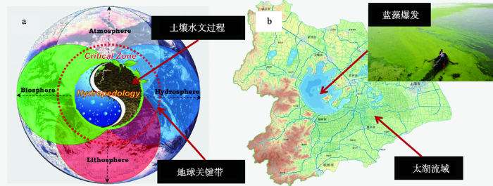
地球关键带(Earth's Critical Zone)处于地表岩石圈、水圈、土壤圈和生物圈的交互地带(图1a),地球关键带土壤水文过程及其与环境因子之间的交互关系是近年来国内外关注的新兴交叉研究方向(Lin et al, 2005; Pachepsky et al, 2006; Vepraskas et al, 2009)。研究土壤水文过程对探讨营养盐在地表不同界面之间的输移和交换至关重要,这是因为土壤水文过程是营养盐迁移的主要驱动力,同时土壤水文过程影响土壤的理化性质,决定着土壤中水分和营养盐的有效性(Zhu et al, 2012)。因此,土壤水文过程决定了土壤中营养盐迁移和循环,对于控制水体富营养化和农业面源污染具有重要的环境意义。
图1 (a)地球关键带土壤水文过程和(b)太湖流域蓝藻爆发
Fig.1 (a) Soil hydrological processes in Earth’s Critical Zone and (b) cyanobacterial blooms of the Taihu Lake
东南湿润区是我国生态环境问题最为突出的区域之一,水体的富营养化是该区域当前面临的主要经济和社会发展问题之一(图1b)。相关研究发现,太湖流域土地开发利用是该区域的水体富营养化诱因之一(李恒鹏等, 2004)。近年来,在太湖流域丘陵区(面积6151.23 km2,占流域总面积的16.67%),受政府鼓励和市场推动的双重作用,越来越多的生态型用地(竹林)向经济型用地(茶园)转变,这种转变在带来巨大经济效益的同时,地表关键带土壤水文过程也发生着剧烈的变化(Vepraskas et al, 2009; Liao, Lai, Liu et al, 2016),进而深刻影响着营养盐的输移循环,已经引发了河湖水质下降等一系列生态环境问题。比如,(韩莹等(2012))研究发现太湖丘陵区茶园对氮磷的利用效率远低于竹林和水田,该区域农业综合开发对流域水环境已造成严重的负面影响;(杨超杰等(2017))同样认为,太湖丘陵河谷区水质主要受茶园种植等农业活动导致的面源污染的影响。可见,太湖流域丘陵区的生态环境问题应引起高度重视。
坡面是丘陵区的基本空间单元,研究坡面土壤水文过程可为深入理解太湖流域丘陵区营养盐输移循环奠定重要基础。目前,坡面尺度土壤水文过程研究主要通过室内和野外试验观测、数理统计分析、数值模拟等手段实现(Lan et al, 2013)。近年来,随着观测手段的进步和计算机技术的快速发展,很多学者在野外实际流域开展了坡面水文循环的精细观测与模拟研究,如德国Weiherbach实验流域(Bárdossy et al, 1998)、新西兰Maimai实验流域(Weiler et al, 2007)、美国Andrew森林流域(McGuire et al, 2007)、Panola实验流域(Freer et al, 2002)、Hecla Greens Creek矿区山坡(Hopp et al, 2009)、Shale Hills实验流域(Shi et al, 2015)等。在国内,以傅伯杰为代表的科研人员系统地分析了黄土丘陵区坡面土壤水文过程,并开发了相应的数学模型(Fu et al, 2001; Qiu et al, 2010)。然而,目前有关太湖流域丘陵区坡面土壤水文过程试验观测与模拟研究相对较少,主要是由于该地区土壤砾石含量高(>40%)、渗透能力强且土层很薄(<1 m),难以形成地表径流,坡面产流主要以壤中流形式为主,而壤中流野外观测比较困难,严重制约了对该地区土壤水文循环和营养盐输移过程的机理解析。
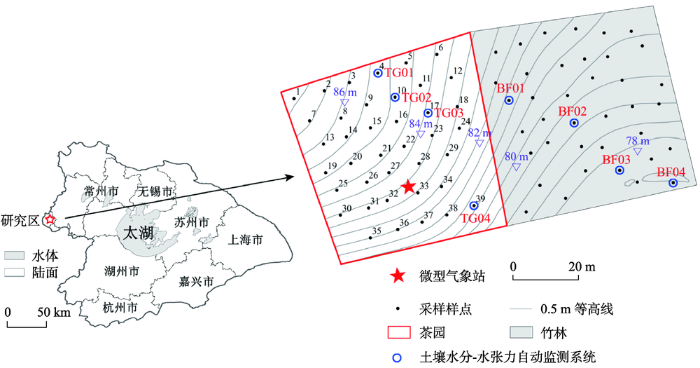
基于太湖流域丘陵坡地开发和土地利用方式改变的现状,选取两个相邻但用地类型不同的坡面,如竹林和茶园,分别代表生态型用地和经济型用地(图2)。在国家自然科学基金青年科学基金项目“太湖流域丘陵区坡面土壤水文过程物理机制及模拟研究(项目批准号:41301234;起止年月:2014年1月-2016年12月)”的资助下,重点开展了3个方面的研究,包括:①不同土地利用坡面土壤水分时空变化与影响因素;②坡面水文过程与水量平衡;③坡面土壤水文过程影响机制。上述研究对区域水土资源可持续利用、农业水肥管理以及水体富营养化防治都有十分重要的科学与实践意义。
图2 研究区位置和坡面土壤水文观测布点
Fig.2 Location of the study area and hillslope soil hydrologic observation stations
研究区具体位于南京高淳区东坝镇北部青山茶厂内(31°21′N,119°03′E),选取了茶园(Camellia sinensis (L.) O. Kuntze)(15a生)和竹林地(Phyllostachys edulis (Carr.) H. de Lehaie)(30a生毛竹林)两个土地利用坡面(图2),土壤类型以薄层粗骨土为主,土壤质地主要为粉质壤土(Liao, Lai, Lv et al, 2016)。在坡面上以8 m为取样间隔,共设置77个监测样点,其中茶园39个,竹林38个。测定的数据包括土壤数据与地形数据:①土壤体积含水量、土壤水张力、气象因子(降水量、相对湿度、温度、太阳辐射、风速和风向)(图3)、土壤砾石含量、质地、有机质含量、总氮(TN)、总磷(TP)和总钾(TK);②根据南京市国土资源局提供的1:1000 地形图,生成 1 m分辨率的坡面数字高程模型(DEM),利用ArcGIS提取高程、坡度、坡向、平面曲率、剖面曲率和地形湿度指数。
图3 自动监测系统、土壤剖面情况和微型气象站
Fig.3 Automatic monitoring system, soil profile condition, and mini weather station
采用平均值和变异系数(CV)等经典统计参数描述典型坡面土壤水分变化的统计特征。CV值可反映土壤水分变异程度,CV≤10%为弱变异性,CV在10%~100%之间为中等变异性,CV≥100%为强变异性。此外,还采用地统计学方法研究坡面土壤水分时空变异特征,该方法以区域化变量理论为基础,以变异函数为主要工具,利用原始数据和半方差函数的结构性,对未采样点的区域化变量进行无偏估值的一种方法。变异函数的拟合模型包括球状模型、指数模型、高斯模型和线性模型等,可根据最大决定系数(R2)和最小残差平方和(RSS)来选取最优拟合模型,从而得到4个重要的参数,即:基台值C+C0(sill)、块金值C0(nugget)、空间异质比(C0/C+C0)和变程A0(range)(Cambardella et al, 1994)。坡面土壤水分影响因素则采用相关性分析和多元逐步回归方法进行定量识别。
本研究采用 HYDRUS-2D 模型(Šimůnek et al, 1999)来模拟坡面土壤水文过程,该模型采用二维Richards 方程来描述坡面土壤水分运动过程。描述土壤水力学特性的参数包括土壤水分特征曲线θ(h)和非饱和导水率K,采用广泛应用的van Genuchten-Mualem模型(Mualem, 1976; van Genuchten, 1980)进行描述。
假设初始土壤含水量在坡面上均匀分布,通过一定时期的模型“预热”,逐渐减小初始条件的影响。模型上边界设置为大气边界,坡顶位于分水岭处且与外界无水量交换,设为零通量边界,坡脚边界设置为自由排水。潜在蒸散量ETp采用Hargreaves公式计算,并根据叶面积指数(LAI)划分为潜在蒸发率(Ep)和潜在蒸腾率(Tp)(Ritchie, 1972),茶园和竹林的消光系数均设为0.52(Liao et al, 2014; Liao, Lv et al, 2016)。此外,根系吸水过程采用van Genuchten宏观模型(van Genuchten, 1987)进行描述。
基于坡面土壤水文过程模型,设置了不同情境模式(降雨模式、土壤质地、坡度)预测分析坡面壤中流通量及其控制机制。共设置216种不同条件组合的情境:①2种用地类型:茶园和竹林;②每种用地类型下设置3种坡度条件:坡度平缓(5%),原有模型坡度不变(茶园:8.12%;竹林:10.80%),中等斜坡(20%);③每个坡度条件下设置6种土壤质地类型:壤砂土、壤土、粉土、粉壤土、黏壤土和黏土,利用HYDRUS模型内嵌的ROSETTA神经网络模块预测得到各质地类型土壤的水力学参数(如θr、θs、α、n 和Ks,l统一设为0.5);④每种土壤质地条件下设置6种降雨模式,从情境Ⅰ至情境Ⅵ,降雨频率逐渐减小,降雨强度逐渐增加。
在观测期内,由于受降雨和气温变化的影响,茶园和竹林不同深度土壤水分的平均值和变异系数随时间变化明显,其中竹林土壤水分明显高于茶园,这可能与林地根系发达、涵养水分强有关。同时研究还发现茶园和竹林土壤含水量平均值与前期降雨量(前7天累计降雨量)之间均存在明显的正相关关系(Liao, Zhou et al, 2017)。茶园和竹林均属于中等的变异性,这与(刘宏伟等(2016))的研究基本一致,他们发现在太湖流域湿润地区土壤水分呈中等或者中等偏弱变异性。茶园土壤水分的变异性高于竹林,这可能是因为茶园的管理措施对地表土壤的扰动强,导致土壤水分破碎化程度较高,而竹林为天然林地,人为的干扰小,因而土壤水分的空间连续性较好(杜志勇等, 2007)。
通过对茶园和竹林土壤水分进行地统计分析,发现竹林的块金值小于茶园,说明竹林土壤水分空间分布的随机性比茶园弱(Liao et al, 2017a)。竹林和茶园土壤水分的变程之间无显著差异,而竹林土壤水分的空间异质比总体要小于茶园,说明竹林土壤水分具有更强的空间相关性,这与基于变异系数的统计特征分析结论一致。同时,利用Spearman相关性分析对不同用地类型土壤水分空间变异影响因素进行研究,发现坡面土壤水分空间变化主要受土地利用、土壤性质和地形特征等环境因子的共同作用,与以往的研究结论相一致(Grayson et al, 1997; Western et al, 2004; Williams et al, 2009)。通过分析不同用地类型坡面土壤水分时空变异与影响因素,对于太湖流域水土资源可持续利用和农业水肥管理具有较强的现实意义。
基于HYDRUS-2D模型,对2013年1月1日至2014年8月23日共计600天的茶园和林地坡面土壤水文过程进行模拟,发现模型对土壤水分模拟的纳什效率系数(NSE)均高于0.6,取得了较好的模拟效果(Liao, Lv et al, 2016; Liao et al, 2017b)。同时研究还发现,与下层(30 cm深度)相比,表层(10 cm深度)土壤水分的模拟精度较高,这可能是由于下层(30 cm深度)土壤水分容易受到大孔隙流和指流的影响,导致模拟效果较差。验证期茶园和林地坡面水量平衡模拟结果表明,坡面水分来源主要为降雨,消耗于蒸散发,坡面径流形式为壤中流,无地表径流产生,这可能与试验区坡面砾石含量较高(>40%),使得土壤渗透性好,从而促进壤中流的产生有关(王小燕等, 2012)。(段剑等(2017))通过对江西红壤湿润区坡地壤中流的研究时也发现,在自然降雨条件下壤中流输出量显著高于地表径流,成为降雨径流的主要输出形式。
研究还表明,根系吸水在春季和夏季表现最为强烈,并在降水事件后,出现明显增强的趋势。此外,竹林根系吸水量显著大于茶园。这可能是由于竹林根系分布较深,根量也较多,促进了根系吸水过程。然而,在冬季(12月至次年2月),竹林的根系吸水略小于茶园,可能与竹林在冬季处于非生长季有关(陈红等, 2013)。茶园土壤蒸发量略大于竹林,可能与茶园叶面积指数相对较小,受太阳直射影响导致土壤蒸发强烈有关;而竹林叶面积指数较大,对太阳辐射具有一定的削减作用,使得土壤蒸发强度较弱。此外,还对茶园和林地坡面壤中流过程与降水关系进行了研究,发现一般在降雨后1~2天会发生明显的壤中流过程,且随降水量的增加有逐渐增多的趋势。(谢颂华等(2015))对自然降雨期红壤湿润区坡地壤中流产流过程进行分析,也发现壤中流流量与降水量呈极显著的正相关关系。总体来看,茶园的壤中流流量明显大于竹林,这也从侧面反映竹林土壤的涵养水源能力更强,而茶园土壤对水分涵养和利用能力较低,这可能与茶园耕作措施(行间沟)使得土壤孔隙度增大(林绍霞等, 2012),进而提高了土壤的透水性能有关。
茶园和竹林壤中流的产生存在明显的前期坡面平均含水量阈值,分别为0.18和0.31 cm3/cm3,壤中流随着前期平均含水量的增加而增加(图4),这与以往的研究结论类似。比如,Penna等(2011)分析了土壤含水量对坡面径流产生的影响,发现当土壤较为干旱时的壤中流流量较小,但当前期土壤含水量超过0.45 cm3/cm3时壤中流流量显著增加;(Zhao等(2015))则发现该阈值约为0.30 cm3/cm3。不同研究得到的阈值有所差异,可能与研究区地形、土壤类型、土地利用和气候条件的不同有关,而该阈值也是面源污染物坡面迁移的重要控制因子。通过分析不同用地类型坡面土壤水文过程与水量平衡,对于探讨土地利用剧烈变化背景下的太湖流域生态环境保护措施具有重要的科学意义。
图4 (a)茶园和(b)竹林坡面壤中流与前期土壤平均含水量的关系
Fig.4 Correlations between subsurface flow and antecedent mean soil moisture content on tea garden and bamboo forest hillslopes
基于多情景(土地利用、降雨模式、土壤质地、坡度)模拟分析,进一步探讨了坡面壤中流与环境因子之间的关系(图5)。从降雨情景来看,壤中流量从情景Ⅰ到情景Ⅵ逐渐增加。(陈晓安等(2017))通过分析雨强对红壤湿润区坡耕地壤中流的影响,也发现壤中流径流强度随雨强增大而增加,且不同雨强下壤中流量峰值相近。在相同的降雨情景下,不同土壤质地条件下产生的壤中流也有所不同,其中壤砂土壤中流量大于其他质地类型,可能与其较高的饱和导水率有关。对于不同的坡度情景,随着坡度的增加壤中流也显著增加,是由于坡度越大水分受重力影响越大、下渗能力越强(Lan et al, 2013; 侯旭蕾等, 2013)。在不同情景条件下,茶园坡面产生的壤中流(161.80~783.68 mm)均要远大于竹林(118.61~605.89 mm)。(Schume等(2003))的研究也认为,土地利用方式和植被覆盖改变了水分循环过程各要素的水量分配,比如竹林能提高冠层截留、增加蒸散量等。
图5 基于多情景模拟的坡面壤中流与环境因子之间的关系
Fig.5 Correlations between hillslope subsurface flow and environmental factors based on simulations under different scenarios
基于上述分析,降雨对茶园和竹林坡面壤中流均具有实质性的影响。历时短、强度大的降雨能显著增加壤中流,这与(Wanke等(2008))的研究结论一致。在观测期内,每当强降雨事件过后,壤中流迅速增加并到达峰值。可以推断,未来的极端降雨事件将会显著增加坡面的壤中流(Brolsma et al, 2010),而以往研究表明,壤中流的产生总是伴随着高浓度氮磷流失(Pionke et al, 1988; Zhu et al, 2011)。(常龙飞等(2012))研究发现巢湖典型低山丘陵区坡面营养盐随壤中流流失非常显著,且氮素流失主要以溶解态为主,而磷素主要以有机溶解态形式流失。因此,未来极端降雨事件可能会增加营养盐流失风险,进而加剧太湖水体富营养化和流域农业面源污染。对于太湖流域丘陵坡地的开发利用,需要综合考虑坡面土地利用类型、坡度以及土壤质地等条件。比如,茶园坡面产生的壤中流要远大于竹林,同时其前期坡面平均含水量阈值要小于竹林,表明在相同土壤水分条件下,茶园坡面更易产生壤中流,进而增加氮磷等营养盐流失的风险,因此需合理控制茶园扩张规模,适当实施保护性耕作方式,提高坡面水分利用效率,同时应严格限制粗质地土壤和较大坡度的丘陵区坡面开发成茶园。此外,在对坡面土地利用进行规划设计时,可分段规划设计不同土地利用方式,优化配置坡面土地利用组合模式,削弱坡面壤中流的产流量,尽量降低因土地利用方式转变所引发的营养盐随壤中流流失的风险,实现坡地的可持续利用。
湖泊流域控源减负是国家“十三五”重点攻关目标,湖泊流域资源环境关系到老百姓切身利益,关系到全面小康和现代化建设进程。东南湿润区土地利用变化剧烈改变了土壤水文过程,进而深刻影响着氮磷等营养元素的迁移和转化,导致了流域农业面源污染问题。目前流域和坡面土壤水文过程与影响机制研究虽已取得诸多成果,但仍有以下几个方面的问题需进一步研究:
(1) 流域尺度土壤水文过程及其影响机制。当前流域土壤水文过程的相关研究多集中在中小尺度,如平原区农田尺度和丘陵区坡面尺度,缺乏对全流域土壤水文过程的机理认识。由于土壤水文过程尺度效应的存在,不同空间尺度的土壤水文效应、机理和影响因素存在显著差异,亟需在以往研究的基础上,结合多要素土壤水文综合观测、数值模拟、3S技术和数理统计分析等手段,实现土壤水文过程研究的尺度提升和机理过程分析。
(2) 土壤水文过程与营养盐输移耦合机制。在土壤水文过程研究的基础上,开展坡面壤中流与坡面流相互转化过程及机制研究,并进一步分析土壤氮磷等营养盐输移循环过程。以往土壤水文过程与营养盐输移研究是相互割裂的,各自为政,缺乏有效、紧密的耦合与集成,导致营养盐输移模拟精度及机理解释存在瓶颈,可结合土壤水动力模型(如HYDRUS)、生物地球化学模型(如DNDC)以及地球物理探测技术等,实现土壤水文过程和营养盐输移循环精确模拟和耦合机制解析。
(3) 流域尺度土壤营养盐流失与风险评估。在解决上述问题(1)和(2)的基础上,可结合流域土地利用、地形、土壤性质等生成土壤水文响应单元,实现流域尺度土壤营养盐流失模拟和空间尺度拓展,进而揭示营养盐流失的热点时间、区域和驱动机制,对营养盐流失强度进行预测和风险评估,提出靶向性的流域营养盐和土地利用空间优化管控措施,从而为湖泊水体富营养化和流域面源营养盐污染控制提供决策支持。
致谢:感谢北京大学遥感与地理信息系统研究所范闻捷副教授在本文写作过程中给予的悉心指导。文中部分插图由南京大学吕立刚博士、中科院南京地理与湖泊研究所赖晓明博士清绘,在此一并表示感谢!
The authors have declared that no competing interests exist.
| [1] |
巢湖典型低山丘陵区不同土地利用类型壤中流养分流失特征 [J].https://doi.org/10.3969/j.issn.1673-4831.2012.05.007 URL Magsci [本文引用: 1] 摘要
以巢湖典型低丘山区坡地的6种主要土地利用类型(弃耕地、尾矿裸地、灌木林地、荒草地、马尾松林地和人工恢复林地)为研究对象,通过定位观测与收集坡面壤中流,探讨该地区壤中流养分流失动态变化特征。结果表明,巢湖低丘山区典型土地利用类型壤中流发生概率为灌木林地和荒草地较高,尾矿裸地最低(仅在0~20 cm 土层产生);表层壤中流氮含量为尾矿裸地最高,人工恢复林地最低,壤中流磷含量为弃耕地最高,尾矿裸地最低; 壤中流氮素流失以溶解态NO<sub>3</sub><sup>-</sup>-N为主,并随雨季的到来而呈下降趋势,随土层加深呈先下降后升高趋势;磷主要以有机溶解态形式流失,随土层加深而呈下降趋势。相关分析表明,地表总盖度、地表植被均匀度、土壤养分含量与壤中流氮、磷含量间存在显著相关性,而降雨特征(降雨量、降雨强度)与壤中流氮、磷含量间相关性不显著。由于人为开采严重,在分析该地区壤中流氮素含量时,应注意干湿沉降的影响。
Characteristics of soil nutrient loss with interflow from uplands as affected by land uses in low hill region of Chaohu Basin [J].https://doi.org/10.3969/j.issn.1673-4831.2012.05.007 URL Magsci [本文引用: 1] 摘要
以巢湖典型低丘山区坡地的6种主要土地利用类型(弃耕地、尾矿裸地、灌木林地、荒草地、马尾松林地和人工恢复林地)为研究对象,通过定位观测与收集坡面壤中流,探讨该地区壤中流养分流失动态变化特征。结果表明,巢湖低丘山区典型土地利用类型壤中流发生概率为灌木林地和荒草地较高,尾矿裸地最低(仅在0~20 cm 土层产生);表层壤中流氮含量为尾矿裸地最高,人工恢复林地最低,壤中流磷含量为弃耕地最高,尾矿裸地最低; 壤中流氮素流失以溶解态NO<sub>3</sub><sup>-</sup>-N为主,并随雨季的到来而呈下降趋势,随土层加深呈先下降后升高趋势;磷主要以有机溶解态形式流失,随土层加深而呈下降趋势。相关分析表明,地表总盖度、地表植被均匀度、土壤养分含量与壤中流氮、磷含量间存在显著相关性,而降雨特征(降雨量、降雨强度)与壤中流氮、磷含量间相关性不显著。由于人为开采严重,在分析该地区壤中流氮素含量时,应注意干湿沉降的影响。
|
| [2] |
植物根系生物学研究进展 [J].https://doi.org/10.3969/j.issn.1004-7549.2011.02.002 URL [本文引用: 1] 摘要
The root biology is a cross-cutting discipline focused on the research on plant root system that has emerged in a decade. Its research areas cover morphology, physiology, developmental biology, molecular biology and genetics. Root biology as the important ecological and agricultural index plays important guiding role in protecting and utilizing plant resources, improving genetic quality of plants and increasing productivity. This paper summarized the research advance of plant root biology in recent years in terms of root architecture, root growth and soil conditions, rhizosphere, anatomical structure of root and genetic improvementof root. Meanwhile it clarified the significance for studying root biology and discussed the problems arising in recent research. Finally, some suggestions were put forward for the future development of root biology.
Research Advance of Plant Root Biology [J].https://doi.org/10.3969/j.issn.1004-7549.2011.02.002 URL [本文引用: 1] 摘要
The root biology is a cross-cutting discipline focused on the research on plant root system that has emerged in a decade. Its research areas cover morphology, physiology, developmental biology, molecular biology and genetics. Root biology as the important ecological and agricultural index plays important guiding role in protecting and utilizing plant resources, improving genetic quality of plants and increasing productivity. This paper summarized the research advance of plant root biology in recent years in terms of root architecture, root growth and soil conditions, rhizosphere, anatomical structure of root and genetic improvementof root. Meanwhile it clarified the significance for studying root biology and discussed the problems arising in recent research. Finally, some suggestions were put forward for the future development of root biology.
|
| [3] |
雨强和坡度对红壤坡耕地地表径流及壤中流的影响 [J].https://doi.org/10.11975/j.issn.1002-6819.2017.09.018 URL [本文引用: 1] 摘要
地表径流和壤中流是坡面重要水文过程,雨强和坡度是影响坡面地表径流和壤中流产流主要因素。为研究降雨强度和地表坡度对坡耕地地表径流和壤中流的影响,该文采用人工模拟降雨试验法,在长3.0 m、宽1.5 m、深0.5 m土槽,设计4个不同坡度(5°、10°、15°、20°)和3个不同雨强(30、60、90 mm/h)对红壤坡耕地地表径流及壤中流产流过程进行模拟试验。结果表明:1)壤中流开始产流时间滞后于地表径流,降雨强度从30到90 mm/h,地表径流、壤中流产流开始时间均随雨强增大而减小,壤中流比地表产流开始滞后时间随着雨强增大先增大后趋于稳定;2)地表径流强度随雨强增大而增大,壤中流初始径流强度随雨强增大而增大,不同雨强下壤中流径流峰值相近;3)地表径流和壤中流产流过程曲线有明显差异,地表径流产流过程线先增大后趋于稳定,壤中流产流过程线呈抛物线型即先增大后减小;4)从5°到20°,地表产流开始时间随坡度增大而减小,壤中流产流开始时间随坡度增大先减小后增大;5)从5°到20°,地表径流强度先增大后减小,10°为转折坡度,壤中流产流峰值随坡度增大而减小,并且随着坡度增大达到壤中流峰值时间不断减小。
Effects of rainfall intensity and slope on surface and subsurface runoff in red soil slope farmland [J].https://doi.org/10.11975/j.issn.1002-6819.2017.09.018 URL [本文引用: 1] 摘要
地表径流和壤中流是坡面重要水文过程,雨强和坡度是影响坡面地表径流和壤中流产流主要因素。为研究降雨强度和地表坡度对坡耕地地表径流和壤中流的影响,该文采用人工模拟降雨试验法,在长3.0 m、宽1.5 m、深0.5 m土槽,设计4个不同坡度(5°、10°、15°、20°)和3个不同雨强(30、60、90 mm/h)对红壤坡耕地地表径流及壤中流产流过程进行模拟试验。结果表明:1)壤中流开始产流时间滞后于地表径流,降雨强度从30到90 mm/h,地表径流、壤中流产流开始时间均随雨强增大而减小,壤中流比地表产流开始滞后时间随着雨强增大先增大后趋于稳定;2)地表径流强度随雨强增大而增大,壤中流初始径流强度随雨强增大而增大,不同雨强下壤中流径流峰值相近;3)地表径流和壤中流产流过程曲线有明显差异,地表径流产流过程线先增大后趋于稳定,壤中流产流过程线呈抛物线型即先增大后减小;4)从5°到20°,地表产流开始时间随坡度增大而减小,壤中流产流开始时间随坡度增大先减小后增大;5)从5°到20°,地表径流强度先增大后减小,10°为转折坡度,壤中流产流峰值随坡度增大而减小,并且随着坡度增大达到壤中流峰值时间不断减小。
|
| [4] |
退化红壤区不同模式重建森林土壤水分空间变异性 [J].https://doi.org/10.3321/j.issn:1009-2242.2007.05.024 URL [本文引用: 1] 摘要
采用地统计学的方法,研究了江西泰和退化红壤区不同模式重建森林在高温干旱季节土壤水分空间变异规律及其分布格局。结果表明,在该研究尺度下,湿地松纯林、枫香纯林、湿地松与枫香混交林O~20cm,20~40cm土层含水量分布都符合正态分布,都可较好地拟合成球状模型,表现出明显的空间相关性和空间分布格局。3种重建模式样地0~20cm,20~40cm层土壤含水量变异函数的基台值、变程都较无林荒地明显增大,而且基台值和变程在0~20cm,20~40cm两土层间的差异明显大于无林荒地,说明植被恢复以后,土壤水分的空间分布特征明显改变,空间变异性增强,空间变异的程度和尺度都明显增大,土壤水分的空间变异也具有较为明显的层次性。与纯林相比,湿地松×枫香混交林土壤水分的空间变异程度较低,水分分布趋于均匀化。
Spatial variability of soil moisture in different models of rehabilitated forest in degraded red soil region [J].https://doi.org/10.3321/j.issn:1009-2242.2007.05.024 URL [本文引用: 1] 摘要
采用地统计学的方法,研究了江西泰和退化红壤区不同模式重建森林在高温干旱季节土壤水分空间变异规律及其分布格局。结果表明,在该研究尺度下,湿地松纯林、枫香纯林、湿地松与枫香混交林O~20cm,20~40cm土层含水量分布都符合正态分布,都可较好地拟合成球状模型,表现出明显的空间相关性和空间分布格局。3种重建模式样地0~20cm,20~40cm层土壤含水量变异函数的基台值、变程都较无林荒地明显增大,而且基台值和变程在0~20cm,20~40cm两土层间的差异明显大于无林荒地,说明植被恢复以后,土壤水分的空间分布特征明显改变,空间变异性增强,空间变异的程度和尺度都明显增大,土壤水分的空间变异也具有较为明显的层次性。与纯林相比,湿地松×枫香混交林土壤水分的空间变异程度较低,水分分布趋于均匀化。
|
| [5] |
不同下垫面红壤坡地壤中流对自然降雨的响应 [J].Responses of subsurface flow characteristics to natural rainfall in red soil slopes of different surface covers [J]. |
| [6] |
太湖上游低山丘陵地区不同用地类型氮、磷收支平衡特征 [J].https://doi.org/10.18307/2012.0604 URL [本文引用: 1] 摘要
不同用地类型的土壤氮、磷收支平衡决定了氮、磷在土壤的富集,进一步影响氮、磷的流失强度,分析该过程有助于揭示不同用地类型对区域的环境效应.以位于太湖上游低山丘陵地区的天目湖流域为研究区,采用农户调查问卷、土壤和植被生物量实验分析、文献调研和氮、磷表观平衡模型的方法,选择研究区的茶园、水田、马尾松林和竹林四种典型用地类型,系统分析了氮、磷的输入要素,包括肥料输入、大气沉降、秸秆返田/枯枝落叶、生物固氮、人畜排泄物返田,以及输出要素,包括植物生长吸收、氨挥发、反硝化,并比较不同用地类型氮、磷收支特征.在此基础上进一步与土壤表层氮、磷含量比较,揭示太湖流域上游丘陵山区主要用地类型的水环境效应.研究结果显示:土壤氮、磷盈余量大小顺序为茶园水田马尾松林竹林,分别是648.6、248.9、115.5、53.6 kgN/(hm2.a)和319.9、29.7、1.2和-3.4 kgP/(hm2.a);氮、磷利用效率以竹林最高,茶园的氮、磷利用效率均最低,仅为15.0%和3.1%;土壤氮盈余量与表层氮含量未能呈现出一致的关系,土壤磷盈余量与表层磷含量比较类似,并由此得出竹林比马尾松林更有利于水环境保护,而茶园对水环境的不利影响超过水田.
Nitrogen and phosphorus budget of different land use types in hilly area of Lake Taihu upper-river basin [J].https://doi.org/10.18307/2012.0604 URL [本文引用: 1] 摘要
不同用地类型的土壤氮、磷收支平衡决定了氮、磷在土壤的富集,进一步影响氮、磷的流失强度,分析该过程有助于揭示不同用地类型对区域的环境效应.以位于太湖上游低山丘陵地区的天目湖流域为研究区,采用农户调查问卷、土壤和植被生物量实验分析、文献调研和氮、磷表观平衡模型的方法,选择研究区的茶园、水田、马尾松林和竹林四种典型用地类型,系统分析了氮、磷的输入要素,包括肥料输入、大气沉降、秸秆返田/枯枝落叶、生物固氮、人畜排泄物返田,以及输出要素,包括植物生长吸收、氨挥发、反硝化,并比较不同用地类型氮、磷收支特征.在此基础上进一步与土壤表层氮、磷含量比较,揭示太湖流域上游丘陵山区主要用地类型的水环境效应.研究结果显示:土壤氮、磷盈余量大小顺序为茶园水田马尾松林竹林,分别是648.6、248.9、115.5、53.6 kgN/(hm2.a)和319.9、29.7、1.2和-3.4 kgP/(hm2.a);氮、磷利用效率以竹林最高,茶园的氮、磷利用效率均最低,仅为15.0%和3.1%;土壤氮盈余量与表层氮含量未能呈现出一致的关系,土壤磷盈余量与表层磷含量比较类似,并由此得出竹林比马尾松林更有利于水环境保护,而茶园对水环境的不利影响超过水田.
|
| [7] |
坡度对红壤土坡面降雨侵蚀及水文过程的影响 [J].https://doi.org/10.7631/j.issn.1672-3317.2013.06.031 URL [本文引用: 1] 摘要
通过室内模拟降雨试验,研究了坡度对红壤土坡面降雨、产沙、产流、入渗等坡面水文过程的影响。结果表明,相同的降雨条件下,不同坡度红壤土坡面开始产流时间总体上随着坡度的增大逐渐推迟;不同坡度下的坡面产沙强度波动较大;产沙强度随坡度的增大先增大后减小,在15。~20。坡度附近出现临界坡度;不同坡度下地表入渗强度随产流时间呈指数下降,坡面产流强度呈对数上升趋势;随着坡度的不断增大,地表产流总量逐渐减小,相应地入渗总量逐渐增加。
Effect of slope gradients on rainfall erosion and hydrological process on red soil land-slope [J].https://doi.org/10.7631/j.issn.1672-3317.2013.06.031 URL [本文引用: 1] 摘要
通过室内模拟降雨试验,研究了坡度对红壤土坡面降雨、产沙、产流、入渗等坡面水文过程的影响。结果表明,相同的降雨条件下,不同坡度红壤土坡面开始产流时间总体上随着坡度的增大逐渐推迟;不同坡度下的坡面产沙强度波动较大;产沙强度随坡度的增大先增大后减小,在15。~20。坡度附近出现临界坡度;不同坡度下地表入渗强度随产流时间呈指数下降,坡面产流强度呈对数上升趋势;随着坡度的不断增大,地表产流总量逐渐减小,相应地入渗总量逐渐增加。
|
| [8] |
太湖流域浙西区不同土地类型的面源污染产出 [J].https://doi.org/10.3321/j.issn:0375-5444.2004.03.010 URL [本文引用: 1] 摘要
以太湖流域浙西水利分区为研究区,采用Arcgis的水文分析模块,对浙西区进行流域划分,选取以单一农业用地为主的子流域,利用GIS叠加分析方法,获取各子流域的降水、径流深度、土地利用结构信息,分析研究区主要土地利用类型与径流量的统计关系,建立该区年尺度的径流估算模型。基于林地、耕地为主的子流域水质监测数据,结合径流估算模型,分析占该区90%土地利用面积的林地、耕地与径流污染物浓度的定量关系,研究结果显示,该研究区以林地为主的流域径流各水环境指标为:COD浓度为2.95 mg/l,BOD浓度为1.080 mg/l,总氮浓度为0.715 mg/l,总磷浓度为0.039 mg/l;耕地为主的流域径流水环境指标为:COD浓度为5.721mg/l,BOD浓度为3.097 mg/l,总氮浓度为2.092 mg/l,总磷浓度为0.166 mg/l。这一研究结果适合应用于太湖流域上游山区、丘陵地区年尺度面源污染估算。
The non-point output of different landuse types in Zhexi hydraulic region of Taihu Basin [J].https://doi.org/10.3321/j.issn:0375-5444.2004.03.010 URL [本文引用: 1] 摘要
以太湖流域浙西水利分区为研究区,采用Arcgis的水文分析模块,对浙西区进行流域划分,选取以单一农业用地为主的子流域,利用GIS叠加分析方法,获取各子流域的降水、径流深度、土地利用结构信息,分析研究区主要土地利用类型与径流量的统计关系,建立该区年尺度的径流估算模型。基于林地、耕地为主的子流域水质监测数据,结合径流估算模型,分析占该区90%土地利用面积的林地、耕地与径流污染物浓度的定量关系,研究结果显示,该研究区以林地为主的流域径流各水环境指标为:COD浓度为2.95 mg/l,BOD浓度为1.080 mg/l,总氮浓度为0.715 mg/l,总磷浓度为0.039 mg/l;耕地为主的流域径流水环境指标为:COD浓度为5.721mg/l,BOD浓度为3.097 mg/l,总氮浓度为2.092 mg/l,总磷浓度为0.166 mg/l。这一研究结果适合应用于太湖流域上游山区、丘陵地区年尺度面源污染估算。
|
| [9] |
不同垦植模式茶园土壤性状及团聚体特征研究 [J].Research for soil properties and aggregates in tea plantation with different planting patterns [J]. |
| [10] |
湿润地区坡面土壤含水率时空变异性研究 [J].Study on temporal-spatial variability of soil moisture content on hillslope in a humid area [J]. |
| [11] |
砾石覆盖紫色土坡耕地水文过程 [J].
紫色土中砾石分布广泛,地表常为砾石覆盖,砾石覆盖对土壤水文过程有着重要影响。试验小区(2 m×1 m)为坡度23°的坡耕地, 试验降雨强度为(53.9±2.8)mm/h、 (90.8±6.1)mm/h和(134.3±14.9)mm/h, 砾石覆盖度为0%,11%,20%,33%和42%。通过原位人工模拟降雨试验,定量研究了不同降雨强度下砾石覆盖对降雨入渗、地表产流及壤中流产流的影响。结果表明:砾石覆盖对入渗过程影响显著,稳定入渗速率及稳定入渗系数与砾石覆盖度呈正相关关系,3种降雨强度下,稳定入渗系数分别为47.70%~86.59%,30.61%~82.83%、17.76%~77.44%,42%砾石覆盖度小区的稳定入渗速率分别是裸露小区的1.95~4.94倍;地表砾石覆盖延迟地表产流、减少地表径流量,地表产流时间随着砾石覆盖度的提高呈增加趋势,地表径流速率及地表径流系数随砾石覆盖度的增加而降低,相对地表径流系数与地表砾石覆盖度呈指数负相关关系;地表砾石覆盖促进壤中流的发生、增加壤中流量,壤中流产流时间随着砾石覆盖度的增加逐渐缩短,壤中流径流速率及壤中流径流系数随地表砾石覆盖度的增加而提高,相对壤中流径流系数与地表砾石覆盖度呈指数正相关关系。
Hydrological processes on sloped farmland in purple soil regions with rock fragment cover [J].
紫色土中砾石分布广泛,地表常为砾石覆盖,砾石覆盖对土壤水文过程有着重要影响。试验小区(2 m×1 m)为坡度23°的坡耕地, 试验降雨强度为(53.9±2.8)mm/h、 (90.8±6.1)mm/h和(134.3±14.9)mm/h, 砾石覆盖度为0%,11%,20%,33%和42%。通过原位人工模拟降雨试验,定量研究了不同降雨强度下砾石覆盖对降雨入渗、地表产流及壤中流产流的影响。结果表明:砾石覆盖对入渗过程影响显著,稳定入渗速率及稳定入渗系数与砾石覆盖度呈正相关关系,3种降雨强度下,稳定入渗系数分别为47.70%~86.59%,30.61%~82.83%、17.76%~77.44%,42%砾石覆盖度小区的稳定入渗速率分别是裸露小区的1.95~4.94倍;地表砾石覆盖延迟地表产流、减少地表径流量,地表产流时间随着砾石覆盖度的提高呈增加趋势,地表径流速率及地表径流系数随砾石覆盖度的增加而降低,相对地表径流系数与地表砾石覆盖度呈指数负相关关系;地表砾石覆盖促进壤中流的发生、增加壤中流量,壤中流产流时间随着砾石覆盖度的增加逐渐缩短,壤中流径流速率及壤中流径流系数随地表砾石覆盖度的增加而提高,相对壤中流径流系数与地表砾石覆盖度呈指数正相关关系。
|
| [12] |
自然降雨事件下红壤坡地壤中流产流过程特征分析 [J].https://doi.org/10.14042/j.cnki.32.1309.2015.04.009 URL [本文引用: 1] 摘要
为研究红壤坡地的壤中流输出特征,采用野外大型土壤入渗装置,对红壤坡面草地和裸地不同深度(30 cm和60 cm)壤中流输出开展自然降雨-产流过程的观测试验.结果表明:①壤中流产流过程随着土层的加深,滞后时间和拖尾时间均延长,与降雨过程相适性减弱.草地壤中流产流量、峰值、产流历时均大干裸地,其差异在突发型降雨下表现更为明显;②壤中流产流量和降雨量呈显著性正相关(R2为0.6942~0.8770),但与雨强关系不明显.突发型和峰值型降雨壤中流产流过程洪峰升涨迅速,而均匀型壤中流产流过程平缓.突发型、峰值型和均匀型降雨裸地壤中流产流量与地表径流量相比分别为13.82%、91.73%和159.04%,草地则为118.95%、312.11%和368.33%;③土壤前期含水量增加,壤中流产流滞后时间缩短,峰值和流量增大.
Analysis on the characteristic of interflow production processes on red soil slopes in the case of natural rainfall events [J].https://doi.org/10.14042/j.cnki.32.1309.2015.04.009 URL [本文引用: 1] 摘要
为研究红壤坡地的壤中流输出特征,采用野外大型土壤入渗装置,对红壤坡面草地和裸地不同深度(30 cm和60 cm)壤中流输出开展自然降雨-产流过程的观测试验.结果表明:①壤中流产流过程随着土层的加深,滞后时间和拖尾时间均延长,与降雨过程相适性减弱.草地壤中流产流量、峰值、产流历时均大干裸地,其差异在突发型降雨下表现更为明显;②壤中流产流量和降雨量呈显著性正相关(R2为0.6942~0.8770),但与雨强关系不明显.突发型和峰值型降雨壤中流产流过程洪峰升涨迅速,而均匀型壤中流产流过程平缓.突发型、峰值型和均匀型降雨裸地壤中流产流量与地表径流量相比分别为13.82%、91.73%和159.04%,草地则为118.95%、312.11%和368.33%;③土壤前期含水量增加,壤中流产流滞后时间缩短,峰值和流量增大.
|
| [13] |
太湖典型丘陵水源地水质时空变化及影响因素分析: 以平桥河流域为例 [J].https://doi.org/10.11870/cjlyzyyhj201702013 URL [本文引用: 1] 摘要
基于太湖流域典型丘陵水源地平桥河流域12个采样点的水质监测数据,综合运用聚类分析和主成分分析法对平桥河流域水质时空变化及影响因素进行分析。聚类分析显示,按照水质相似性将平桥河流域水质分为枯水期、平水期、丰水期3个季节时段和中上游丘陵河谷区、下游紧邻平桥镇的平原区、下游暗沟出口区3个典型空间区域。主成分分析显示:(1)枯水期水质以氮污染为主导因素,磷和有机污染次之,受流量减小、流速缓慢导致的营养盐富集的影响加大;平水期水质以氮污染为主导因素,磷污染次之,受茶园等大量施肥导致的农业面源污染的影响;丰水期水质以氮和磷污染为主导因素,受到水稻种植等农业活动和大量降雨径流的影响。(2)中上游丘陵河谷区水质以氮和磷污染为主导因素,有机污染次之,受到茶园种植等农业活动导致的面源污染的影响;下游紧邻平桥镇的平原区水质以氮和磷的污染为主导因素,有机污染次之,受到居民生活污水和农业生产的影响;下游暗沟出口区水质以氮污染为主导因素,有机污染和磷污染次之,受到生活污水、农业生产和畜禽养殖的影响。研究结果可为太湖流域丘陵区水源地保护和管理提供参考。
Analysing the spatial and temporal variations and influencing factors of the water quality in a typical hilly water source of Lake Taihu Basin: A case study in Pingqiao river watershed [J].https://doi.org/10.11870/cjlyzyyhj201702013 URL [本文引用: 1] 摘要
基于太湖流域典型丘陵水源地平桥河流域12个采样点的水质监测数据,综合运用聚类分析和主成分分析法对平桥河流域水质时空变化及影响因素进行分析。聚类分析显示,按照水质相似性将平桥河流域水质分为枯水期、平水期、丰水期3个季节时段和中上游丘陵河谷区、下游紧邻平桥镇的平原区、下游暗沟出口区3个典型空间区域。主成分分析显示:(1)枯水期水质以氮污染为主导因素,磷和有机污染次之,受流量减小、流速缓慢导致的营养盐富集的影响加大;平水期水质以氮污染为主导因素,磷污染次之,受茶园等大量施肥导致的农业面源污染的影响;丰水期水质以氮和磷污染为主导因素,受到水稻种植等农业活动和大量降雨径流的影响。(2)中上游丘陵河谷区水质以氮和磷污染为主导因素,有机污染次之,受到茶园种植等农业活动导致的面源污染的影响;下游紧邻平桥镇的平原区水质以氮和磷的污染为主导因素,有机污染次之,受到居民生活污水和农业生产的影响;下游暗沟出口区水质以氮污染为主导因素,有机污染和磷污染次之,受到生活污水、农业生产和畜禽养殖的影响。研究结果可为太湖流域丘陵区水源地保护和管理提供参考。
|
| [14] |
Spatial distribution of soil moisture in a small catchment. Part 1: Geostatistical analysis [J].https://doi.org/10.1016/S0022-1694(97)00152-2 URL [本文引用: 1] 摘要
Soil moisture measurements were performed weekly at about 60 locations in a small catchment (6.3 km 2 ) in southwest Germany over a period of 6 years. The measurements were carried out by using time domain reflectometry at four different depths. The data was analyzed and a time independent semivariogram was derived. For interpolation, five different methods, ordinary kriging, external drift kriging, indicator kriging, external drift indicator kriging and Bayes-Markov updating were used. Additional information such as topographical parameters derived from a digital elevation model, were used to improve the estimation in the external drift methods. In the Bayesian case, even qualitative information such as land use could be used. Depending on the assumptions, the interpolated maps differed significantly. The performance of the different methods was compared using a cross-validation approach. The results indicate improvement in the interpolation quality by using the topographic index or land use as additional information.
|
| [15] |
Climate change impact on a groundwater-influenced hillslope ecosystem [J].https://doi.org/10.1029/2009WR008782 [本文引用: 1] 摘要
This study investigates the effect of climate change on a groundwater-influenced ecosystem on a hill slope consisting of two vegetation types, one adapted to wet and one adapted to dry soil conditions. The individual effects of changes in precipitation, temperature, and atmospheric CO2 concentration are compared to the combined effect of these factors. Change in atmospheric conditions is based on the Netherlands. Projected climate change is obtained from an ensemble of nested global and regional climate models (GCMs and RCMs), representing the Intergovernmental Panel on Climate Change Special Report on Emissions Scenarios A2 scenario for 2100. For each GCM-RCM combination, change factors were determined and transferred to a stochastic weather generator. All projections show higher temperatures and less annual precipitation. Simulations were performed using an ecohydrological model, consisting of a dynamic soil-plant-atmosphere-continuum model that is fully coupled to a variably saturated hydrological model, using the stochastic weather data as input. Model results show that increasing atmospheric CO2 concentration results in higher biomasses because of higher water use efficiency and a decrease in evaporation downslope where vegetation growth is light limited. The change in precipitation regime (drier summers, wetter winters) causes a decreased biomass of especially the dry-adapted species and increased upslope groundwater recharge, resulting in groundwater rise and an upward shift of wet-adapted vegetation. Temperature rise results in decreased biomass because respiration increases stronger than carbon assimilation, while increased transpiration causes drier soils and a prolonged period of water-limited growth. The combined effect is dominated by the increase in temperature and change in precipitation regime, causing decreased biomass throughout. Surprisingly, the effect on groundwater level depends on the degree by which precipitation distribution changes within the year, showing a drop at a small change and a rise when change is larger. This study thus shows that climate change effects on hydrology and vegetation are far from straightforward and call for fully coupled ecohydrological models and upslope-downslope interaction.
|
| [16] |
Field-scale variability of soil properties in central Iowa soils [J].https://doi.org/10.2136/sssaj1994.03615995005800050033x URL [本文引用: 1] 摘要
Spatial distributions of soil properties at the field and watershed scale may affect yield potential, hydrologic responses, and transport of herbicides and NO3- to surface or groundwater. Our research describes field-scale distributions and spatial trends for 28 different soil parameters at two sites within a watershed in central Iowa. Two of 27 parameters measured at one site and 10 of 14 parameters measured at the second site were normally distributed. Spatial variability was investigated using semivariograms and the ratio of nugget to total semivariance, expressed as a percentage, was used to classify spatial dependence. A ratio of <25% indicated strong spatial dependence, between 25 and 75% indicated moderate spatial dependence, and >75% indicated weak spatial dependence. Twelve parameters at Site one, including organic C, total N, pH, and macroaggregation, and four parameters at Site two, including organic C and total N, were strongly spatially dependent. Six parameters at Site one, including biomass C and N, bulk density, and denitrification, and 9 parameters at Site two, including biomass C and N and bulk density, were moderately spatially dependent. Three parameters at Site one, including NO3- N and ergosterol, and one parameter at Site two, mineral-associated N, were weakly spatially dependent. Distributions of exchangeable Ca and Mg at Site one were not spatially dependent. Spatial distributions for some soil properties were similar for both field sites. We will be able to exploit these similarities to improve our ability to extrapolate information taken from one field to other fields within similar landscapes.
|
| [17] |
The role of bedrock topography on subsurface storm flow [J].https://doi.org/10.1029/2001WR000872 URL [本文引用: 1] 摘要
We conducted a detailed study of subsurface flow and water table response coupled with digital terrain analysis (DTA) of surface and subsurface features at the hillslope scale in Panola Mountain Research Watershed (PMRW), Georgia. Subsurface storm flow contributions of macropore and matrix flow in different sections along an artificial trench face were highly variable in terms of timing, peak flow, recession characteristics, and total flow volume. The trench flow characteristics showed linkages with the spatial tensiometer response defining water table development upslope. DTA of the ground surface did not capture the observed spatial patterns of trench flow or tensiometric response. However, bedrock surface topographic indices significantly improved the estimation of spatial variation of flow at the trench. Point-scale tensiometric data were also more highly correlated with the bedrock surface-based indices. These relationships were further assessed for temporal changes throughout a rainstorm. Linkages between the bedrock indices and the trench flow and spatial water table responses improved during the wetter periods of the rainstorm, when the hillslope became more hydrologically connected. Our results clearly demonstrate that in developing a conceptual framework for understanding the mechanisms of runoff generation, local bedrock topography may be highly significant at the hillslope scale in some catchments where the bedrock surface acts as a relatively impermeable boundary.
|
| [18] |
A mathematical model of soil moisture spatial distribution on the hillslopes of the loess plateau [J].https://doi.org/10.1007/BF02909778 URL [本文引用: 1] 摘要
Based on important factors that affect soil moisture spatial distribution, such as the slope gradients, land use, vegetation cover, and surface water diffusion characteristics together with field measurements of soil moisture data obtained from the surface soil under different land use structures, a soil moisture spatial distribution model was established. The diffusion degree coefficient of surface water for different vegetations was estimated from soil moisture values obtained from field measurements. The model can be solved using the finite unit method. The soil moisture spatial distribution on the hill slopes in the Loess Plateau were simulated by the model. A comparison of the simulated values with measurement data shows that the model is a good fit.
|
| [19] |
Preferred states in spatial soil moisture patterns: Local and nonlocal controls [J].https://doi.org/10.1029/97WR02174 URL [本文引用: 1] 摘要
In this paper we develop a conceptual and observational case in which soil water patterns in temperate regions of Australia switch between two preferred states. The wet state is dominated by lateral water movement through both surface and subsurface paths, with catchment terrain leading to organization of wet areas along drainage lines. We denote this as nonlocal control. The dry state is dominated by vertical fluxes, with soil properties and only local terrain (areas of high convergence) influencing spatial patterns. We denote this as local control. The switch is described in terms of the dominance of lateral over vertical water fluxes and vice versa. When evapotranspiration exceeds rainfall, the soil dries to the point where hydraulic conductivity is low and any rainfall that occurs essentially wets up the soil uniformly and is evapotranspired before any significant lateral redistribution takes place. As evapotranspiration decreases and/or rainfall increases, areas of high local convergence become wet, and runoff that is generated moves downslope, rapidly wetting up the drainage lines. In the wet to dry transitional period a rapid increase in potential evapotranspiration (and possibly a decrease in rainfall) causes drying of the soil and "shutting down" of lateral flow. Vertical fluxes dominate and the "dry" pattern is established. Three data sets from two catchments are presented to support the notion of preferred states in soil moisture, and the results of a modeling exercise on catchments from a range of climatic conditions illustrate that the conclusions from the field studies may apply to other areas. The implications for hydrological modeling are discussed in relation to methods for establishing antecedent moisture conditions for event models, for distribution models, and for spatially distributing bulk estimates of catchment soil moisture using indices.
|
| [20] |
Hillslope hydrology under glass: Confronting fundamental questions of soil-water-biota co-evolution at Biosphere 2 [J].https://doi.org/10.5194/hessd-6-4411-2009 URL [本文引用: 1] 摘要
Recent studies have called for a new unifying hydrological theory at thehillslope and watershed scale, emphasizing the importance of coupled processunderstanding of the interactions between hydrology, ecology, pedology,geochemistry and geomorphology. The Biosphere 2 Hillslope Experiment isaimed at tackling this challenge and exploring how climate, soil andvegetation interact and drive the evolution of the hydrologic hillslopebehavior. A set of three large-scale hillslopes (18 m by 33 m each) will bebuilt in the climate-controlled experimental biome of the Biosphere 2facility near Tucson, Arizona, USA. By minimizing the initial physicalcomplexity of these hillslopes, the spontaneous formation of flow pathways,soil spatial heterogeneity, surface morphology and vegetation patterns canbe
|
| [21] |
A two-dimensional numerical model coupled with multiple hillslope hydrodynamic processes and its application to subsurface flow simulation [J].https://doi.org/10.1007/s11431-013-5347-6 URL [本文引用: 2] |
| [22] |
Uncertainty analysis in near-surface soil moisture estimation on two typical land-use hillslopes [J].https://doi.org/10.1007/s11368-016-1405-6 URL [本文引用: 1] 摘要
Purpose Spatial prediction of near-surface soil moisture content (NSSMC) is necessary for both hydrologic modeling and land use planning. However, uncertainties associated with the prediction are...
|
| [23] |
Uncertainty in predicting the spatial pattern of soil water temporal stability at the hillslope scale [J].https://doi.org/10.1071/SR15059 URL [本文引用: 1] 摘要
Soil water temporal stability is subject to spatial variation, which influences the prediction of mean soil water status on a hillslope. However, estimation of the spatial pattern of soil water temporal stability and quantification of the uncertainties associated with the predictions are often ignored. In this study, volumetric soil water contents at 10 and 30cm depths on tea garden and forest hillslopes were monitored across 17 dates from January 2013 to April 2014. Soil moisture maps on these 17 dates were interpolated using ordinary kriging and then the spatial distribution of the relative difference of soil moisture was assessed. Based on these maps, standard deviations of relative difference (SDRD) of soil moisture were calculated to represent the spatial variation of soil water temporal stability. Uncertainties in predicted patterns of SDRD due to the limited number of sampling days used for calculating SDRD (U1) and for spatial interpolation of soil moisture by ordinary kriging (U2) were investigated using bootstrap and sequential Gaussian simulation techniques respectively. Results showed that soil water content on the forest hillslope generally exhibited stronger spatial variability than that on the tea garden hillslope. The SDRD substantially varied in space at the hillslope scale. Temporal stabilities of soil water content at 30cm depth were significantly (P<0.05) stronger than those at 10cm soil depth, regardless of the land use type. However, differences in soil water temporal stabilities on these two land use hillslopes were not significant. In addition, U2 was generally more important than U1 on both hillslopes. This suggests that additional sampling sites and more robust interpolation methods rather than additional sampling days should be developed to reduce SDRD prediction uncertainty on the study hillslopes.
|
| [24] |
a. Applying fractal analysis to detect spatio-temporal variability of soil moisture content on two contrasting land use hillslopes [J].https://doi.org/10.1016/j.catena.2017.05.022 URL [本文引用: 1] 摘要
Abstract Soil moisture variations in space and time are critical in ecological, hydrological, pedological and environmental studies. This study used fractal analysis to detect the spatio-temporal variability of soil moisture on two contrasting land use hillslopes in the hilly area of Taihu Lake Basin of China. Surface (0 20 cm) soil moisture data from January 2013 to September 2015 (a total of 37 sampling days) were analyzed at 39 and 38 sites on the tea garden and forest hillslopes, respectively, with a spatial resolution of about 8 m. Results showed that the forest hillslope was significantly (P < 0.05) wetter than the tea garden hillslope. The spatial mean soil moisture on both hillslopes had a significant negative linear correlation (R = 0.753 for tea garden (P < 0.05) and R = 0.459 for forest (P < 0.05)) with corresponding CV for 37 sampling dates. The fractal dimension (D) was found to be better than the nugget/sill ratio in describing the spatial dependence of soil moisture. The advantage of the D is that it does not require the modelling of the semivariogram since it can be calculated on the basis of the experimental semivariogram. Soil moisture on the forest hillslope showed stronger spatial dependence than that on the tea garden hillslope according to D. However, the soil moisture on both hillslopes showed similar temporal dependence and a low-to-moderate autocorrelation structure. In addition, the temporal variability of soil moisture content was spatially correlated on tea garden hillslope. If a location is temporally autocorrelated, the locations nearby tend also to be temporally autocorrelated. It would be possible to make more accurate moisture trend predictions for temporal autocorrelated locations with small D. These findings had important applications related to sampling design, simulation of soil water flow and agricultural water resources management.
|
| [25] |
b. Combining the ensemble mean and bias correction approaches to reduce the uncertainty in hillslope-scale soil moisture simulation [J].https://doi.org/10.1016/j.agwat.2017.05.014 URL [本文引用: 1] 摘要
The ROSETTA model has routinely been applied to predict the soil hydraulic properties for simulating the water flow at the hillslope scale. However, the uncertainties in water flow simulations are substantial due to the soil heterogeneity and ROSETTA model structure. In order to reduce these uncertainties, this study used the HYDRUS-2D and ensemble mean to simulate soil moisture based on the outputs of all candidate models. In addition, the bias correction techniques (including linear bias correction (LBC) and cumulative distribution function (CDF) matching) were also applied to improve the prediction of soil moisture. A total of 320days of observed soil moisture data at two depths (10 and 30cm) in the upper and lower slope positions were adopted to evaluate the performances of different bias correction methods results showed that the uncertainty in hillslope-scale soil moisture simulation due to the ROSETTA model structure was more important than that due to the soil heterogeneity. The CDF matching-based nonlinear bias correction approach was generally better than the LBC in reducing the uncertainty in soil moisture simulation. Combining the ensemble mean and CDF matching was a viable approach to improve the accuracy of the numerical model for simulating the hillslope-scale soil moisture variations.
|
| [26] |
Sensitivity of simulated hillslope subsurface flow to rainfall patterns, soil texture and land use [J].https://doi.org/10.1111/sum.12282 URL [本文引用: 2] 摘要
Abstract Knowledge of the generation of subsurface flow for hillslopes is important for controlling agricultural nonpoint nutrient losses. This study used a physically based hillslope hydrologic model HYDRUS-2D to assess the sensitivity of simulated subsurface flow to the interactions between precipitation, soil texture and land use. Soil moisture data from 1 January 2013 to 23 August 2014 at two monitoring sites on a tea plantation hillslope were used to calibrate the van Genuchten–Mualem hydraulic parameters for this model. For six different textural classes (loamy sand, loam, silt, silt loam, clay loam and clay) and four land-use types (tea garden, forest, grassland and bare soil), scenario-based simulations were carried out for varied precipitation intensities (6.0, 15.0, 30.0, 45.0, 60.0 and 76.002mm/day) and frequencies (time intervals of 1, 5, 10, 15, 20 and 2502days). Results indicated that the hillslope run-off was dominated by subsurface flow, which was influenced by precipitation and antecedent moisture conditions. A threshold value of 0.1802m3/m3 of mean hillslope soil moisture was observed for the initiation of subsurface flow. High precipitation intensity (i.e. 75.002mm/day) substantially increased subsurface flow for all soil textures. In addition, the sensitivity of the bare soil hillslope to rainfall patterns was more than two times higher than that of the vegetated (i.e. grassland, tea garden and forest) hillslope. These findings suggest that extreme precipitation events and land-use change will increase the risks of subsurface flow on hillslopes. Therefore, optimal fertilizer application strategy and land-use planning should be proposed for controlling the hillslope nonpoint nutrient losses.
|
| [27] |
Using different multimodel ensemble approaches to simulate soil moisture in a forest site with six traditional pedotransfer functions [J].https://doi.org/10.1016/j.envsoft.2014.03.016 URL [本文引用: 1] 摘要
61Different multimodel ensemble approaches were used to simulate soil moisture contents.61The simple model average method always had worse performance than the best single model.61The performance of the superensemble approach was better than that of the best single model.
|
| [28] |
Evaluation of different approaches for identifying optimal sites to predict mean hillslope soil moisture content [J].https://doi.org/10.1016/j.jhydrol.2017.01.043 URL [本文引用: 1] 摘要
The identification of representative soil moisture sampling sites is important for the validation of remotely sensed mean soil moisture in a certain area and ground-based soil moisture measurements in catchment or hillslope hydrological studies. Numerous approaches have been developed to identify optimal sites for predicting mean soil moisture. Each method has certain advantages and disadvantages, but they have rarely been evaluated and compared. In our study, surface (0–2002cm) soil moisture data from January 2013 to March 2016 (a total of 43 sampling days) were collected at 77 sampling sites on a mixed land-use (tea and bamboo) hillslope in the hilly area of Taihu Lake Basin, China. A total of 10 methods (temporal stability (TS) analyses based on 2 indices, K-means clustering based on 6 kinds of inputs and 2 random sampling strategies) were evaluated for determining optimal sampling sites for mean soil moisture estimation. They were TS analyses based on the smallest index of temporal stability (ITS, a combination of the mean relative difference and standard deviation of relative difference (SDRD)) and based on the smallest SDRD, K-means clustering based on soil properties and terrain indices (EFs), repeated soil moisture measurements (Theta), EFs plus one-time soil moisture data (EFsTheta), and the principal components derived from EFs (EFs-PCA), Theta (Theta-PCA), and EFsTheta (EFsTheta-PCA), and global and stratified random sampling strategies. Results showed that the TS based on the smallest ITS was better (RMSE02=020.02302m 3 02m 613 ) than that based on the smallest SDRD (RMSE02=020.03402m 3 02m 613 ). The K-means clustering based on EFsTheta (-PCA) was better (RMSE <0.02002m 3 02m 613 ) than these based on EFs (-PCA) and Theta (-PCA). The sampling design stratified by the land use was more efficient than the global random method. Forty and 60 sampling sites are needed for stratified sampling and global sampling respectively to make their performances comparable to the best K-means method (EFsTheta-PCA). Overall, TS required only one site, but its accuracy was limited. The best K-means method required <8 sites and yielded high accuracy, but extra soil and terrain information is necessary when using this method. The stratified sampling strategy can only be used if no pre-knowledge about soil moisture variation is available. This information will help in selecting the optimal methods for estimation the area mean soil moisture.
|
| [29] |
Advances in Hydropedology [J].https://doi.org/10.1016/S0065-2113(04)85001-6 URL [本文引用: 1] |
| [30] |
Integrating tracer experiments with modeling to assess runoff processes and water transit times [J].https://doi.org/10.1016/j.advwatres.2006.07.004 URL [本文引用: 1] 摘要
Representing runoff process complexity in a simple model structure remains a challenge in hydrology. We present an integrated approach to investigate runoff processes using a hillslope tracer experiment and modeling exercise to explore model parameterization, process representation, and transit times. A spatially-explicit model constrained by soil hydrologic properties, runoff, and applied tracer data was used to identify the dominant processes necessary to explain both water and solute flux from a steep hillslope. The tracer data allowed for the rejection of model parameter sets based on the calibration to runoff data alone, thus reducing model uncertainty. The additional calibration to tracer data, improved parameter identifiability and provided further insight to process controls on hillslope-scale water and solute flux. Transit time distributions developed using the model provided further insight to model structure such as subsurface volume, mixing assumptions, and the water table dynamics. Combining field experiments with the modeling exercise may lead to a more comprehensive assessment of runoff process representation in models.
|
| [31] |
A new model for predicting the hydraulic conductivity of unsaturated porous media [J].https://doi.org/10.1029/WR012i003p00513 URL [本文引用: 1] 摘要
A simple analytic model is proposed which predicts the unsaturated hydraulic conductivity curves by using the moisture content-capillary head curve and the measured value of the hydraulic conductivity at saturation. It is similar to the Childs and Collis-George (1950) model but uses a modified assumption concerning the hydraulic conductivity of the pore sequence in order to take into account the effect of the larger pore section. A computational method is derived for the determination of the residual water content and for the extrapolation of the water content-capillary head curve as measured in a limited range. The proposed model is compared with the existing practical models of Averjanov (1950), Wyllie and Gardner (1958), and Millington and Quirk (1961) on the basis of the measured data of 45 soils. It seems that the new model is in better agreement with observations.
|
| [32] |
Hydropedology and pedotransfer functions [J].https://doi.org/10.1016/j.geoderma.2005.03.012 URL [本文引用: 1] 摘要
The emerging interdisciplinary research field of hydropedology attracts a substantial attention because of its promise to bridging pedology and hydrology. Pedotransfer functions (PTFs) emerged as relationships between soil hydraulic parameters and the easier measurable properties usually available from soil survey. One hypothetical explanation of current PTF shortcomings is that PTF inputs do not describe the structure of pore space per se and, therefore, do not represent relationships between structure and function of soil pore space. A possible direction for improvement is to look for PTF predictors that are better related to the structure of water-bearing pathways, in particular using the pedological soil structure description. The objective of this work was to develop and discuss an example of pedotransfer function relating soil structure and soil hydrologic parameters. We used the subset of 2149 samples from the US National Soil Characterization database that had values of water contents at 33 kPa and bulk densities on clods, structure characterized with grade, size and shape, textural class determined in the field and from lab textural analysis. Classification and regression trees were used to group soil samples according to their water contents at 33 kPa. The clay class was the best grouping parameter in all but loamy sand textural classes. The structural parameters served as important grouping variables to define groups of soil samples with distinctly different average water retention for the groups. Defining and quantifying soil structure at various scales, including pedon, hillslope and watershed scales, may contribute for the development scale-relevant PTFs at those scales.
|
| [33] |
The influence of soil moisture on threshold runoff generation processes in an alpine headwater catchment [J].https://doi.org/10.5194/hessd-7-8091-2010 URL [本文引用: 1] 摘要
This study investigates the role of soil moisture on the threshold runoff response in a small headwater catchment in the Italian Alps that is characterised by steep hillslopes and a distinct riparian zone. This study focuses on: (i) the threshold soil moisture-runoff relationship and the influence of catchment topography on this relation; (ii) the temporal dynamics of soil moisture, streamflow and groundwater that characterize the catchment's response to rainfall during dry and wet periods; and (iii) the combined effect of antecedent wetness conditions and rainfall amount on hillslope and riparian runoff. Our results highlight the strong control exerted by soil moisture on runoff in this catchment: a sharp threshold exists in the relationship between soil water content and runoff coefficient, streamflow, and hillslope-averaged depth to water table. Low runoff ratios were likely related to the response of the riparian zone, which was almost always close to saturation. High runoff ratios occurred during wet antecedent conditions, when the soil moisture threshold was exceeded. In these cases, subsurface flow was activated on hillslopes, which became a major contributor to runoff. Antecedent wetness conditions also controlled the catchment's response time: during dry periods, streamflow reacted and peaked prior to hillslope soil moisture whereas during wet conditions the opposite occurred. This difference resulted in a hysteretic behaviour in the soil moisture-streamflow relationship. Finally, the influence of antecedent moisture conditions on runoff was also evident in the relation between cumulative rainfall and total stormflow. Small storms during dry conditions produced low stormflow amounts, likely mainly from overland flow from the near saturated riparian zone. Conversely, for rainfall events during wet conditions, higher stormflow values were observed and hillslopes must have contributed to streamflow.
|
| [34] |
Chemical-hydrologic interactions in the near-stream zone [J].https://doi.org/10.1029/WR024i007p01101 URL [本文引用: 1] 摘要
The chemical and hydrologic responses of a 9.9-ha Pennsylvania hill-land watershed to a typical summer storm event were determined and compared. Patterns and the relative magnitudes of NO, NH, total phosphorus (P), and orthophosphate (PO) concentrations observed in seepage, surface runoff, storm flow, base flow, and rainfall fit those hypothesized from the storm hydrograph and associated water table responses observed in the near-stream zone. Nitrate concentrations in seepage and base flow were similar and, typically, exceeded those in surface runoff, rainfall, and peak storm flow by 5-20 times. Conversely, NH, total P, and POconcentrations in surface runoff from the seep zone and in peak storm flows exceeded those in seepage and base flow by 2-20 times. The findings, presented in a hydrologically based framework for this watershed, provide a conceptual model of how the near-storm zone operates during and following storm events.
|
| [35] |
Spatial prediction of soil moisture content using multiple-linear regressions in a gully catchment of the Loess Plateau, China [J].https://doi.org/10.1016/j.jaridenv.2009.08.003 URL [本文引用: 1] 摘要
The multiple-linear regression models with more readily observed environmental variables (land use and topography) were developed to spatially predict soil moisture content using six methods and their performances and cost-benefit were evaluated using 13 indices in Danangou catchment (3.5 km 2) in the loess area of China. Soil moisture measurements were performed biweekly at five depths in soil profile (0~5 cm, 10~15 cm, 20~25 cm, 40~45 cm and 70~75 cm) on 81 plots from May to September 1999 using time domain reflectometry (TDR). It is indicated that the 13 measured indices almost exhibit the similar conclusions. In terms of fitness, optimum, precision, outlier and cost-benefit, the with-attributes group models, including generalized multiple-linear regression models with environmental attributes (GMLRMs) and stepwise multiple-linear regression models with environmental variables (SMLRMs), were shown to be superior to those multiple-linear regressions models with linear transformation on environmental attributes by principal component analysis (PCA-based group models) and those regression models with nonlinear transformation by detrended correspondence analysis (DCA-based group models). Within each group models, the models using generalized-method or enter-method are better than those using stepwise-method are. However, such within-group differences are not so evident as that of inter-group. Among the six methods, the GMLRMs are the best in terms of fitness, optimum, precision and outlier based on the 11 performance indices, while the SMLRMs are most effective and economical according to the Akaike information criterion (AIC) and Schwarz or Bayesian information criterion (SIC) that can evaluate the cost-benefit of models.
|
| [36] |
Model for predicting evaporation from a row crop with incomplete cover [J].https://doi.org/10.1029/WR008i005p01204 URL [本文引用: 1] 摘要
A model is presented for calculating the daily evaporation rate from a crop surface. It applies to a row crop canopy situation in which the soil water supply to the plant roots is not limited and the crop has not come into an advanced stage of maturation or senescence. The crop evaporation rate is calculated by adding the soil surface and plant surface components (each of these requiring daily numbers for the leaf area index), the potential evaporation, the rainfall, and the net radiation above the canopy. The evaporation from the soil surface Eis calculated in two stages: (1) the constant rate stage in which Eis limited only by the supply of energy to the surface and (2) the falling rate stage in which water movement to the evaporating sites near the surface is controlled by the hydraulic properties of the soil. The evaporation from the plant surfaces Eis predicted by using an empirical relation based on local data, which shows how Eis related to Ethrough the leaf area index. The model was used to obtain the total evaporation rate E = E+ Eof a developing grain sorghum (Sorghum bicolor L.) canopy in central Texas. The results agreed well with values for E measured directly with a weighing lysimeter.
|
| [37] |
Spatio-temporal analysis of the soil water content in a mixed Norway spruce (Picea abies(L.) Karst.)-European beech (Fagus sylvatica L.) stand [J].https://doi.org/10.1016/S0016-7061(02)00311-7 URL [本文引用: 1] 摘要
For a representative measurement of soil water content and its changes at the scale of a forest stand, information about the spatial and temporal variability has to be taken into account. The scale on which single trees and tree species influence the variation in space and time was investigated in a mixed Norway spruce uropean beech stand in Lower Austria. On a 0.5 ha plot the volumetric soil water content (VWC) was measured at 194 sample locations along square grids of different spacing, using a Trase1 TDR system with waveguides installed vertically over a soil depth of 0 30 cm. Discontinuous measurements were taken in approximately 14 day intervals during the growing season of 2000. Semivariogram analysis was used to summarize the spatial variation of VWC at selected dates. Kriging interpolation plots of soil water depletion (recharge) between these dates served to compare extraction (rewetting) patterns to tree (species) distribution. During a long drying cycle in spring, species specific transpiration behaviour turned out to be the main source of variation. Light rainfalls of medium intensity on moderately dry soil caused a rewetting pattern, which reflected the different interception efficiency of the contrasted species resulting from architectural properties. Rain events of high intensity on dry soil led to an erratic distribution pattern of water in the soil due to preferential flow in shrinkage cracks, which had opened up during drying. The effect of tree architecture was largely covered in this case. The extent to which a clear spatial correlation of VWC could be detected varied within a radius of 4 to 20 m, depending on VWC as well as on the drying and rewetting history.
|
| [38] |
Simulating high-resolution soil moisture patterns in the Shale Hills watershed using a land surface hydrologic model [J].https://doi.org/10.1002/hyp.10593 URL [本文引用: 1] 摘要
Abstract Soil moisture is a critical variable in the water and energy cycles. The prediction of soil moisture patterns, especially at high spatial resolution, is challenging. This study tests the ability of a land surface hydrologic model (Flux-PIHM) to simulate high-resolution soil moisture patterns in the Shale Hills watershed (0.08 m2) in central Pennsylvania. Locally measured variables including a soil map, soil parameters, a tree map, and lidar topographic data, all have been synthesized into Flux-PIHM to provide model inputs. The predicted 10-cm soil moisture patterns for 15 individual days encompassing seven months in 2009 are compared with the observations from 61 soil moisture monitoring sites. Calibrated using only watershed-scale and a few point-based measurements, and driven by spatially uniform meteorological forcing, Flux-PIHM is able to simulate the observed macro spatial pattern of soil moisture at ~10-m resolution (spatial correlation coefficient ~ 0.6) and the day-to-day variation of this soil moisture pattern, although it underestimates the amplitude of the spatial variability and the mean soil moisture. Results show that the spatial distribution of soil hydraulic parameters has the dominant effect on the soil moisture spatial pattern. The surface topography and depth to bedrock also affect the soil moisture patterns in this watershed. Using the National Land Cover Database (NLCD) in place of a local tree survey map makes a negligible difference. Field measured soil type maps and soil type-specific hydraulic parameters significantly improve the predicted soil moisture pattern as compared to the most detailed national soils database (Soil Survey Geographic Database, or SSURGO, 30-m resolution). Copyright 2015 John Wiley & Sons, Ltd.
|
| [39] |
The HYDRUS-2D software package for simulating the two-dimensional movement of water, heat, and multiple solutes in variably-saturated media[R]. Version 2.0. Riverside, CA, USA: |
| [40] |
A closed-form equation for predicting the hydraulic conductivity of unsaturated soils [J].https://doi.org/10.2136/sssaj1980.03615995004400050002x URL [本文引用: 1] 摘要
A new and relatively simple equation for the soil-water content-pressure head curve, theta (h), is described in this paper. The particular form of the equation enables one to derive closed-form analytical expressions for the relative hydraulic conductivity, Kr, when substituted in the predictive conductivity models of N.T. Burdine or Y. Mualem. The resulting expressions for Kr(h) contain three independent parameters which may be obtained by fitting the proposed soil-water retention model to experimental data. Results obtained with the closed-form analytical expressions based on the Mualem theory are compared with observed hydraulic conductivity data for five soils with a wide range of hydraulic properties. The unsaturated hydraulic conductivity is predicted well in four out of five cases. It is found that a reasonable description of the soil-water retention curve at low water contents is important for an accurate prediction of the unsaturated hydraulic conductivity.
|
| [41] |
A numerical model for water and solute movement in and below the root zone[R]. Riverside, CA, USA: |
| [42] |
Future directions for hydropedology: quantifying impacts of global change on land use [J].https://doi.org/10.5194/hess-13-1427-2009 URL [本文引用: 2] 摘要
Hydropedology is well positioned to address contemporary issues resulting from climate change. We propose a six step process by which digital, field-scale maps will be produced to show where climate change impacts will be greatest for two land uses: a) home sites using septic systems, and b) wetlands. State and federal laws have defined critical water table levels that can be used to determine where septic systems will function well or fail, and where wetlands are likely to occur. Hydrologic models along with historic rainfall and temperature data can be used to compute long records of water table data. However, it is difficult to extrapolate such data across land regions, because too little work has been done to test different ways for doing this reliably. The modeled water table data can be used to define soil drainage classes for individual mapping units, and the drainage classes used to extrapolate the data regionally using existing digital soil survey maps. Estimates of changes in precipitation and temperature can also be input into the models to compute changes to water table levels and drainage classes. To do this effectively, more work needs to be done on developing daily climate files from the monthly climate change predictions. Technology currently exists to use the NRCS Soil Survey Geographic (SSURGO) Database with hydrologic model predictions to develop maps within a GIS that show climate change impacts on septic system performance and wetland boundaries. By using these maps, planners will have the option to scale back development in sensitive areas, or simply monitor the water quality of these areas for pathogenic organisms. The calibrated models and prediction maps should be useful throughout the Coastal Plain region. Similar work for other climate-change and land-use issues can be a valuable contribution from hydropedologists.
|
| [43] |
Groundwater Recharge Assessment for the Kalahari Catchment of North-eastern Namibia and North-western Botswana with a Regional-scale Water Balance Model [J].https://doi.org/10.1007/s11269-007-9217-5 URL [本文引用: 1] 摘要
Groundwater is the only source of drinking water for the inhabitants of the Kalahari. Thus understanding spatial and temporal variations in groundwater recharge is very important and a regional-scale water balance model has therefore been set up for a 209,14902km 2 catchment in north-eastern Namibia and north-western Botswana. The model has a spatial resolution of 1.565×651.502km, daily model time-steps, and climatic input parameters for 1902years are used. The distributed, GIS-based, process-oriented, physical water balance model (MODBIL) used in this study considers the major water balance components: precipitation, evapotranspiration, groundwater recharge, and surface runoff/interflow. Mean precipitation for the study area is 40902mm a 611 , while mean actual evapotranspiration is 40202mm a 611 and mean groundwater recharge is 802mm a 611 (2% of mean annual precipitation). The recharge pattern is mainly influenced by the distribution of soil and vegetation units. Groundwater recharge shows a high inter- and intra-annual variability, but not only the sum of annual precipitation is important for the development of groundwater recharge; a large amount of precipitation in a relatively short period is more important. Published independent data from the Kalahari in Namibia, Botswana and the Southern African region under similar climatic conditions are used to verify the modelling results.
|
| [44] |
Conceptualizing lateral preferential flow and flow networks and simulating the effects on gauged and ungauged hillslopes [J].https://doi.org/10.1029/2006WR004867 URL [本文引用: 1] 摘要
One of the greatest challenges in the field of hillslope hydrology is conceptualizing and parameterizing the effects of lateral preferential flow. Our current physically based and conceptual models often ignore such behavior. However, for addressing issues of land use change, water quality, and other predictions where flow amount and components of flow are imperative, dominant runoff processes like preferential subsurface flow need to be accounted for in the model structure. This paper provides a new approach to formalize the qualitative yet complex explanation of preferential flow into a numerical model structure. We base our examples on field studies of the well-studied Maimai watershed (New Zealand). We then use the model as a learning tool for improved clarity into the old water paradox and reasons for the seemingly contradictory findings of lateral preferential flow of old water where applied line sources of tracer appear very quickly in the stream following application. We evaluate the model with multiple criteria, including ability to capture flow, hydrograph composition, and tracer breakthrough. We generate output ensembles with different pipe network geometries for model calibration and validation analysis. Surprisingly, the range of runoff response among the ensembles is narrow, indicating insensitivity to specific pipe placement. Our new model structure shows that high transport velocities for artificial line source tracers can be reconciled with the dominance of preevent water during runoff events even when lateral pipe flow dominates response. The work suggests overall that preferential flow can be parameterized within a process-based model structure via the structured dialog between experimentalist and modeler.
|
| [45] |
Spatial correlation of soil moisture in small catchments and its relationship to dominant spatial hydrological processes [J].https://doi.org/10.1016/j.jhydrol.2003.09.014 URL [本文引用: 1] 摘要
The geostatistical properties of soil moisture patterns from five different sites in Australia (Tarrawarra and Point Nepean) and New Zealand (three sites from the Mahurangi River Basin arran's, Clayden's and Satellite Station) are analysed here. The soil moisture data were collected using time domain reflectometry and consistent methods for all sites, thereby allowing comparisons to be drawn between sites without the complication of methodological differences. The sites have contrasting climatic and soils characteristics. Soil moisture in the top 30 cm of the soil profile was measured using time domain reflectometry on 6 8 occasions at each site. The variance and correlation structure of the patterns was analysed. Typical correlation scales lie between 30 and 60 m. We found that there was a seasonal evolution in the spatial soil moisture variance that was related to changes in the spatial mean moisture content at all sites. At the Australian sites there was also a seasonal evolution in the correlation length related to changes in the spatial mean moisture, but not at the New Zealand sites. The seasonal evolution of the correlation length in the Australian catchments is likely to be associated with a seasonal change in the processes controlling the soil moisture pattern. The more humid climate at the New Zealand sites leads to more consistent spatial controls over the year. Similarities between the correlation structure of the moisture and topographic indices representing lateral flow and topographically modulated evaporative forcing were found at Tarrawarra, Carran's and Clayden's. At Point Nepean the correlation structure of the soil moisture pattern is controlled by a larger (than the topography) scale variation in soils, properties and at Satellite Station a smaller scale source of variability is apparent in the data (although there were also topographical effects apparent, associated with valley features). The results demonstrate that the processes controlling spatial patterns can change between places and over time with catchment moisture status; however, when similar general conditions reoccur in a catchment, similar spatial patterns result. Soil characteristics and climate do provide a general pointer to what we might expect but the results also show subtleties specific to place.
|
| [46] |
Controls on the temporal and spatial variability of soil moisture in a mountainous landscape: the signature of snow and complex terrain [J].https://doi.org/10.5194/hessd-5-1927-2008 URL [本文引用: 1] 摘要
The controls on the spatial distribution of soil moisture include static and dynamic variables. The superposition of static and dynamic controls can lead to different soil moisture patterns for a given catchment during wetting, draining, and drying periods. These relationships can be further complicated in snow-dominated mountain regions where soil water input by precipitation is largely dictated by the spatial variability of snow accumulation and melt. In this study, we assess controls on spatial and temporal soil moisture variability in a small (0.02 km), snow-dominated, semi-arid catchment by evaluating spatial correlations between soil moisture and site characteristics through different hydrologic seasons. We assess the relative importance of snow with respect to other catchment properties on the spatial variability of soil moisture and track the temporal persistence of those controls. Spatial distribution of snow, distance from divide, soil texture, and soil depth exerted significant control on the spatial variability of moisture content throughout most of the hydrologic year. These relationships were strongest during the wettest period and degraded during the dry period. As the catchment cycled through wet and dry periods, the relative spatial variability of soil moisture tended to remain unchanged. We suggest that the static properties in complex terrain (slope, aspect, soils) impose first order controls on the spatial variability of snow and resulting soil moisture patterns, and that the interaction of dynamic (timing of water input) and static influences propagate that relative constant spatial variability through most of the hydrologic year. The results demonstrate that snow exerts significant influence on how water is retained within mid-elevation semi-arid catchments and suggest that reductions in annual snowpacks associated with changing climate regimes may strongly influence spatial and temporal soil moisture patterns and catchment physical and biological processes.
|
| [47] |
Soil moisture dynamics and effects on runoff generation at small hillslope scale [J].https://doi.org/10.1061/(ASCE)HE.1943-5584.0001062 URL [本文引用: 1] 摘要
Soil moisture variability has a major impact on runoff generation. In this study, the dynamics and variability of soil moisture at small hillslope transects were analyzed by artificial rainfall simulation experiments in which the influence of crop type and slope angle were considered. Soil moisture variability and dynamics during the rainfall-runoff process were monitored by capacitance sensors (EC-5) with high temporal resolution (1 min) and continuously measured after rainfall ceased to investigate soil moisture dynamics and patterns by the method of data visualization. Relationships between soil moisture and runoff (surface and subsurface flow) and response lag times of soil moisture at different slope positions and soil layers were investigated. The dynamics of soil moisture during the entire crop growth stage were also analyzed. Results showed that soil moisture exerted strong influence on runoff generation, but the relationships were strongly affected by crop type. There was an obvious threshold (approximately 30% vol soil moisture content) between soil moisture and runoff coefficients/surface flow for the wheat crops for both slope angles, but the relationship between soil moisture and runoff was more scattered for spring maize. The response of subsurface flow to soil moisture exhibited hysteretic behavior attributable to soil moisture characteristics and a long recession process and was significantly influenced by slope angle. Lag times between soil moisture and the generation of subsurface flow were both controlled by antecedent soil moisture conditions. During wet conditions, differences in soil moisture response time at different soil layers were small, and obvious subsurface flow could be observed. Conversely, there were large differences between the response times (e.g., the increase in soil moisture for 40-cm depth was close to 0) for rainfall events during dry conditions, and little lateral subsurface flow was observed. Understanding relationships between soil moisture and subsurface flows under different slop angles and vegetation covers will help to improve models that aim to predict the impact of land-use change on runoff and provide useful information for evaluating the effects of soil conservation measures on runoff and sediments in north China.
|
| [48] |
Hot moments and hot spots of nutrient losses from a mixed land use watershed [J].https://doi.org/10.1016/j.jhydrol.2011.11.011 URL [本文引用: 1] 摘要
Non-point nitrogen (N) and phosphorus (P) pollution from agriculture has increasingly received more public attention. In this study, NO 3 –N, dissolved P (DP) and particulate P (PP) concentrations and loads were investigated for four sub-basins (labeled 1–4 going up the watershed) within a mixed land use watershed (39.502ha) in the Appalachian Valley and Ridge Physiographic Province. The hot moments of NO 3 –N concentration and load occurred in base flow and during the non-growing season. Great and temporally variable DP and PP concentrations were observed in storm flow. The hot moments of DP concentration and load were in storm flow from May to December and from September to Nov, respectively, while the hot moments of PP concentration and load were in storm flow from January to June. The NO 3 –N, DP, and PP loads were compared for all four sub-basins on a loss per length of stream reach basis to determine the hot spots and their corresponding losses. The hot spots and hot moments of NO 3 –N loads were in Sub-basins 1 and 4 during the non-growing season base flow period and Sub-basin 2 during the post-growing season base flow period (>11002g02m 611 02mo 611 ). The hot spots of DP loads were also in Sub-basins 1 and 4, but during the growing and post-growing season storm flow period (>1.402g02m 611 02mo 611 ). In contrast, the hot spots and hot moments of PP load were in Sub-basin 3 during the pre-growing and growing season storm flow, as much as 13.4 and 14.102g02m 611 02mo 611 , respectively. Controlling factors of nutrient export were discussed in this study, including season, hydrology (base flow, storm flow, surface and subsurface runoff), and land use. Although different hot moments and hot spots within the watershed were identified for NO 3 –N, DP, and PP losses, the implementation of a couple of management practices (cover crops and no-till) might be sufficient to effectively reduce nutrient losses from this and similar Valley and Ridge watersheds.
|
| [49] |
Nitrogen loss from a mixed land use watershed as influenced by hydrology and seasons [J].https://doi.org/10.1016/j.jhydrol.2011.05.028 URL [本文引用: 1] 摘要
Non-point nitrogen (N) loss from agriculture is an environmental concern among scientists, decision-makers, and the public. This study investigated NO 3 –N and total N losses from a mixed land use watershed (39.5ha) in the Appalachian Valley and Ridge Physiographic Province as influenced by hydrology (flow type, runoff volume, storm sizes, and precipitation amount) and seasons (pre-growing, growing, and post-growing seasons) from 2002 to 2006. Stream discharge was monitored every 5-min and water samples for NO 3 –N and total N analyses were collected weekly for base flow and for every storm. The majority of NO 3 –N (about 75%) and total N (about 65%) were exported in base flow, which contributed about 64% of the total flow in an average year and had greater flow-weighted mean NO 3 –N concentration (5.6mgL 611 ) than storm flow (3.4mgL 611 ). A substantial proportion of total N was in the form of NO 3 –N in base flow (58.1%) and small storms with73% of the overall NO 3 –N and total N losses. These two seasons also had greater flow-weighted mean NO 3 –N (4.8 and 5.5mgL 611 , respectively) and total N (9.8 and 10.1mgL 611 , respectively) concentrations and greater discharge (40% and 32% of total discharge, respectively) than during the growing season. Greater contribution of NO 3 –N to total N loss in storm flow was also observed during the pre-growing and post-growing seasons than during the growing season, while contribution of NO 3 –N to total N loss in base flow was consistent across seasons. Management practices to reduce N loss from this watershed should target periods of base flow when NO 3 –N and total N concentrations are greater (before and after the crop growing season) and target areas along the stream where seeps are present, perhaps including perennial plant species in localized riparian buffers and introducing cover crops on the agricultural land during the fallow season.
|

/
| 〈 |
|
〉 |


