中山大学大气科学学院,广东 珠海 519082
JI Zhenming
收稿日期: 2018-02-28
修回日期: 2018-04-10
网络出版日期: 2018-04-20
版权声明: 2018 地理科学进展 《地理科学进展》杂志 版权所有
基金资助:
作者简介:
作者简介:吉振明(1983-),男,江苏无锡人,博士,副教授,硕导,主要从事气候变化归因和数值模拟研究,E-mail: jizhm3@mail.sysu.edu.cn。
展开
摘要
青藏高原毗邻全球大气污染物排放增长最快速的地区,受西风和南亚季风的影响,中亚、南亚等高原周边排放的污染物通过大气环流传输,进入高原并对其气候环境产生重要影响。观测事实表明:近几十年青藏高原东部和南部雪冰中黑碳含量呈显著上升趋势,这可能导致冰川加速融化和积雪持续时间缩短,最终影响青藏高原的水循环过程。前人对青藏高原黑碳的外源输送,特别是南亚大气污染物的贡献及其对高原气候、冰冻圈变化的影响,还没有较清晰和统一的认识。青藏高原污染物定点监测网络的发展及高分辨率区域气候—大气化学模式的应用,为定量评估高原污染物外源输送及气候效应提供了契机。本文在国家自然科学基金青年科学基金项目“南亚黑碳气溶胶跨境传输及其对青藏高原气候影响的数值模拟研究”的资助下,在以下三个方面取得了进展:①系统性论证了高分辨率区域气候—大气化学模式在高原的适用性,模拟了青藏高原及周边区域黑碳时空分布、传输和沉降过程;②揭示了污染物扩散的机制,评估了大气黑碳的气候及雪冰效应,并对比了自然源粉尘和人为源黑碳对青藏高原气候的影响;③定量估算了不同区域排放对高原黑碳外源输送的贡献率,其中来自南亚的黑碳对青藏高原外源输送的贡献率最高,在非季风期为61.3%,季风期为19.4%。本文揭示了外源输送黑碳对青藏高原气候的影响,为提高一带一路核心区冰冻圈与水资源的管理及预测能力,制定应对环境变化策略及国家气候外交谈判提供科学依据。
关键词:
Abstract
The Tibetan Plateau is surrounded by regions of the fastest growing atmospheric pollutants. The westerlies and the South Asian monsoon circulation transport the pollutants from Central Asia and South Asia to the inland of the Tibetan Plateau, which have important effects on the regional climate and environment. The concentration of black carbon in the snow and ice showed a clearly increasing trend during the recent few decades in the eastern and southern Tibetan Plateau, which might be associated with accelerated melting of snow and glaciers, and directly affected the hydrological processes on the plateau. However, the amount of transboundary transport of black carbon from South Asia is not clear and the knowledge of its impact on climate and cryosphere over the Tibetan Plateau is still limited. The development of atmospheric pollutants monitoring network on the Tibetan Plateau and the application of the high-resolution regional climate-atmospheric chemistry coupled model provide an opportunity for quantitative assessment of external transported pollutants and their climatic effects on the plateau. The project of “Simulation of transboundary transport of black carbon from South Asia and its impact on climate over the Tibetan Plateau,” which was supported by the National Natural Science Foundation of China, focused on the following three aspects: (1) Systematic assessment of the high-resolution regional climate-atmospheric chemistry coupled model performance in the simulation for the Tibetan Plateau. Based on the simulation of distribution, transportation, and deposition processes of black carbon over the Tibetan Plateau and surrounding regions, the climatic effects were investigated; (2) Examination of the mechanism of pollutant diffusion , and evaluation and comparison of the climatic effects induced by the anthropogenic and natural sources; (3) Quantitative estimation of the contribution of external pollutants outside the Tibetan Plateau. The results show that the black carbon from South Asia provided the highest contribution, which was 61.3% in the non-monsoon period and 19.4% in the monsoon season. This study revealed the effect of transboundary black carbon on the Tibetan Plateau, which may provide a scientific basis for improved management and prediction of the cryosphere and water resources in the core region of the Belt and Road initiative, and for police-making of climate change adaption and diplomatic negotiations.
Keywords:
青藏高原有丰富的冰川和积雪资源,被称为“亚洲水塔”,是东亚和南亚的江河源,也是对全球气候变化响应最敏感的地区之一。基于当前观测事实,青藏高原近几十年气温显著增加(Kang et al, 2010),升温加速了高原的雪冰消融,进而对气候环境产生重要影响(陈德亮等, 2015)。青藏高原是地球上最为洁净的地区之一,区域内自身工农业污染排放较少,但是与其毗邻的南亚是全球大气污染物排放增长最快速的地区之一。受不同尺度大气环流的影响,污染物通过远距离传输进入青藏高原。目前,基于地面和遥感监测数据(Xia et al, 2011),并结合中尺度区域气候模式的模拟(Lüthi et al, 2015),识别出南亚大气污染物远距离跨境传输事件与大气环流过程,明确了南亚污染物对高原环境带来的显著影响。
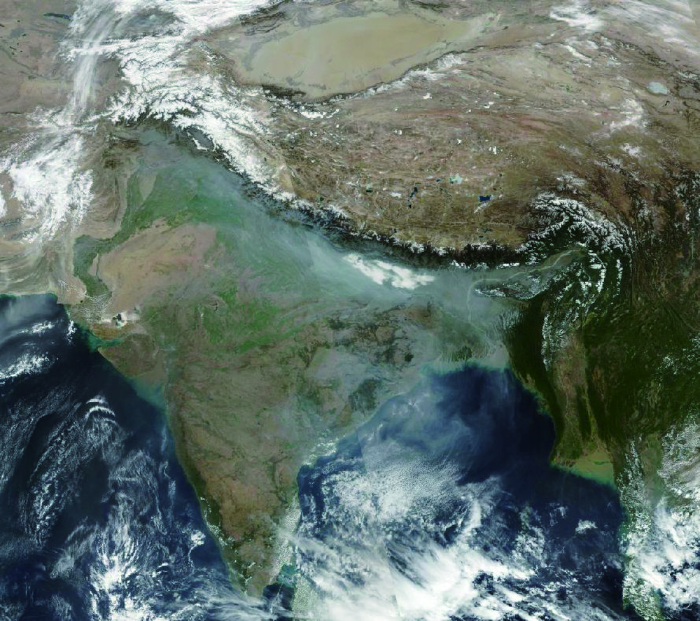
青藏高原周边区域中,南亚的大气污染最为严重,其中最典型的是冬、春季频繁爆发的亚洲棕色云(图1)。大气棕色云中的细颗粒物中有10%~30%的成分为黑碳(Black Carbon, BC)和棕碳(Brown Carbon, BrC)类吸光性气溶胶,这些物质对太阳短波辐射有较强的吸收吸收作用,能强烈改变大气和地表的辐射能量平衡,导致气候进一步变暖,影响
南亚季风气候与青藏高原的水循环过程 (Ramanathan et al, 2007; Ji et al, 2011)。另外,中亚地区近10年石油工业发展产生的排放,也是青藏高原地区大气污染物不可忽视的外部来源(Li et al, 2016),然而相关的研究仍非常有限,对污染物跨境传输的过程、贡献量及其影响缺乏系统和全面的认识。
图1 2018年1月22日亚洲大气棕色云图,数据来源为Aqua/MODIS与Terra/MODIS
Fig.1 The satellite image of Asian brown cloud in Jun 22, 2018, the data was derived from Aqua/MODIS and Terra/MODIS
观测表明,近几十年青藏高原东部和南部雪冰中污染物含量呈显著上升的趋势,而冰芯和湖芯记录则表明整个青藏高原的大气污染物都在增加 (Cong et al, 2013; Kang, Cong et al, 2016; Kang, Huang et al, 2016; Matthewet al, 2016; 张玉兰等, 2017)。大气污染物中的吸光性颗粒物(包括黑碳、生物有机质、矿物粉尘等)随气流进入高原,通过干、湿沉降到雪冰表面之后形成吸光性杂质,这些吸光性杂质对可见光波段有较强烈的吸收作用,并且能够降低雪冰表面反照率,提高雪冰对太阳辐射的吸收效率(Zhang et al, 2018)。近期研究指出,雪冰中的吸光性杂质是冰冻圈加速消融的重要因素之一(Flanner et al, 2011)。而青藏高原雪冰中的吸光性杂质,则可能直接影响“亚洲水塔”的水循环过程(Qian et al, 2015)。之前的研究多数关注气溶胶的监测与时空分布特征,而对于此类吸光性物质的影响缺乏较系统和清晰的认识。
基于“青藏高原大气污染物的外源(特别是南亚地区)输送的过程、贡献量及其气候效应如何”这一科学问题,同时关注到黑碳气溶胶对大气及冰冻圈不可忽视的作用,作者申请了国家自然科学基金青年科学基金项目“南亚黑碳气溶胶跨境传输及其对青藏高原气候影响的数值模拟研究”(项目批准号:41301061;起止年月:2014年1月-2016年12月)。此项研究旨在通过高分辨率区域气候—大气化学模式的模拟,从气候动力学角度揭示南亚黑碳气溶胶的跨境传输过程,定量评估黑碳跨境传输的贡献率及其对青藏高原及周边地区气候的影响。准确评估污染物外源输送的过程,是认识青藏高原现代环境变化的重要环节,揭示大气污染物对青藏高原气候变化的影响机制,对提高一带一路核心区冰冻圈与水资源的管理和预测能力,并为制定应对环境变化策略及国家气候外交谈判提供科学依据。本文是该研究项目成果的综述与讨论。
以往气溶胶传输及气候效应的研究多数基于耦合气溶胶辐射传输模块的全球大气环流模式(Ramanathan et al, 2008; 王志立等, 2009)。全球模式能够很好地反映出人为强迫对气候系统的影响,可用于评估全球尺度大气污染物(如粉尘、汞,POPs等)的传输过程。通常全球模式的水平网格点分辨率一般在125~400 km,无法捕捉到局地强迫的影响,比如不能适当描述复杂地形对污染物的阻挡作用等。在青藏高原地区,全球模式对区域气候的模拟效果并不非常理想(Ji et al, 2013)。相对于一般的全球模式,高分辨率的区域气候模式能够提供较高时空分辨率的气候模拟特征。(Ji等(2013))使用区域气候模式RegCM3针对青藏高原地区进行10 km分辨率的动力降尺度试验,结果表明模拟分辨率的提高可有效地改进模式中模拟气温偏低问题。因此,将全球气候模式得到的结果降尺度到区域级尺度,是研究青藏高原气候变化及其归因的一个重要的方法。
本文使用国际理论物理中心新版的区域气候模式RegCM4.0,该版本是RegCM2 和RegCM3(Pal et al, 2007)的改进版,发布于2010年(Giorgi et al, 2012)。模式主要的物理过程和子模块包括:NCAR CCM3 辐射方案;大尺度云和降水方案(SUBEX);海表通量方案;Holtslag行星边界层方案;陆面过程包括陆面过程的2种选项,BATSle(生物圈—大气圈传输方案)和Common Land Model (CLM)。RegCM4 模式采用MPI 标准编写代码,计算效率较高,可进行高分辨率和长时间段的连续积分模拟。
RegCM4.0 耦合的大气化学过程(气溶胶模块),其传输过程包括水平和垂直平流输送、水平和垂直湍流扩散,积云对流输送,地面排放,大尺度和对流降水清除(湿沉降),干沉降以及物理化学过程中的生成和耗损等。在考虑各种类型气溶胶的辐射特性时,模式给定了单位质量各种类型气溶胶(硫酸盐、水溶性BC和OC、非水溶性BC和OC)不同波长的质量削光效率因子、单次散射反照率和非对称因子参数。其中在计算硫酸盐、水溶性BC和OC气溶胶的光学特性时,考虑了湿度的影响,并且对于不同类型气溶胶采用不同的拟合公式计算其亲水增长。目前模块中只激活了气溶胶的直接辐射效应的模块,其间接效应和半间接效应的耦合模块正在开发中。多年以来,RegCM系列模型已被广泛应用于全球不同地区气溶胶传输及气候效应的模拟研究(Zhang et al, 2009; Marcella et al, 2010; Ji et al, 2011, 2016; Nair et al, 2012; Solmon et al, 2012; Gao et al, 2017),是评估区域尺度气溶胶传输及气候效应的有效方法。
通过在模式中设计不同的敏感试验获取青藏高原黑碳外源传输的贡献率。具体试验方案在表1中给出。试验共包含6组模拟试验,其中参考试验(RF)在模式中考虑了整个模拟区域完整的BC排放清单,试验结果用于验证评估模式的模拟性能。SEN1-SEN5分别代表不同的敏感试验。敏感试验SEN1中关闭了模拟区域人为排放的BC,RF与SEN1之间的差别(RF-SEN1)用来代表BC在整个模拟区域内产生的气候效应。在SEN2 试验中将南亚地区的BC 排放源关闭,RF与SEN2之差(RF-SEN2)被视为南亚BC的气候效应,(RF-SEN2)/RF作为南亚区域BC对整个模拟区域的贡献。由于BC的排放及传输存在显著的区域分布特征,因此,增加了中亚(SEN3)、中国东部(SEN4)及青藏高原以北(SEN5)区域BC排放三组敏感试验,用于和南亚区域的模拟结果进行对比。
表1 试验设置
Tab.1 Black carbon emission scenario of the experiments
| 试验 | 设置 |
|---|---|
| RF | 模拟考虑整个区域完整的BC排放清单 |
| SEN1 | 整个区域BC排放设置为0 |
| SEN2 | 将南亚区域的BC排放设置为0 |
| SEN3 | 将中亚区域的BC排放设置为0 |
| SEN4 | 将中国东部地区的BC排放设置为0 |
| SEN5 | 将青藏高原以北区域的BC排放设置为0 |
观测数据主要用于验证模式的模拟性能,这也是本文的难点之一。由于青藏高原及周边气溶胶观测站点较少,空间分布不均匀,持续较短且不连续,因而较难将这些资料使用于气候学意义上多年模式结果检验。相对而言卫星遥感资料在空间和时间的连续性较好,因此使用卫星反演(MISR、MODIS)的气溶胶光学厚度(AOD)对比模式模拟值,从空间上验证模式的模拟能力。同时结合地面Aeronet 站点数据和大气污染与冰冻圈变化观测网(Atmospheric Pollutants and Cryospheric Change, APCC)的野外台站的监测数据来检验模拟结果。
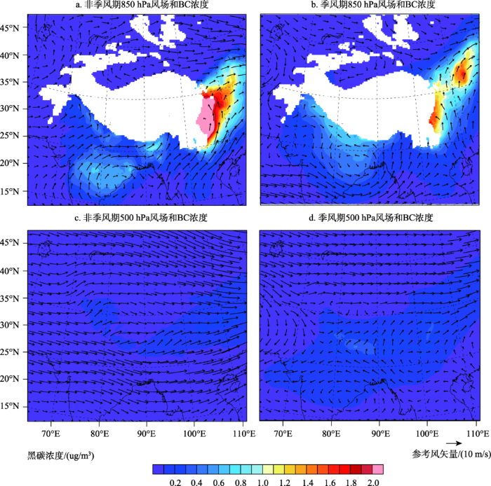
验证模式的模拟能力是整个研究工作的基础。气溶胶的传输和沉降过程与大尺度大气环流、局地扰流、湍流和降水有关。因此,模式对气象要素模拟的准确性直接决定了气溶胶模拟结果的可信度。利用耦合大气化学模块的区域气候模式模拟青藏高原及其周边区域人为排放碳质气溶胶(黑碳、有机碳)的传输和沉降过程。结果表明,模式对青藏高原气温、降水、环流及极端气候事件等要素有较好的模拟能力(Ji et al, 2015),并能合理地再现高原及周边区域人为源气溶胶的时空分布特征(Ji et al, 2015)。大气黑碳湿沉降通量在高原南部季风期(5-9月)大于非季风期(一年中除季风期之外的其他月份),而在高原北部和西部地区则相反。在季风期,南亚BC通过高层大气传输进入青藏高原。干沉降主要受地形的影响,从高原外缘至内陆表现为递减的空间分布特征。BC导致对流层大气产生正短波辐射强迫(图2a, 2b),而在近地面产生负短波辐射强迫(图2c, 2d),辐射强迫绝对值从南向北呈递减趋势,最高值位于南亚地区,数值达到2W·m-2;最低值位于青藏高原,范围在0.1W·m-2以内。季风期含碳气溶胶引起高原西部及中部0.1~0.5°C的增温(图2e);而非季风期除青藏高原南部外,大部地区表现为0.1~0.5°C的增温(图2f)。
图2 碳质气溶胶大气(a, b)、地面(c, d)短波辐射强迫及对气温的影响(e, f), 季风期(a, c, e); 非季风期(b, d, f)(据(
Fig.2 The shortwave radiative forcing of carbonaceous aerosols in the atmosphere (a, b) and surface (c, d), also their effects on the surface temperature (e, f). a, c, e were in monsoon season; b, d, f were in non-monsoon season (Modified from
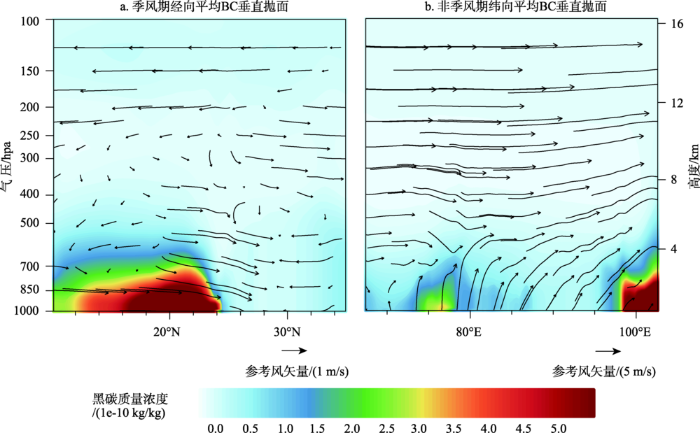
大气环流是气溶胶传输的主要驱动力,青藏高原的阻挡作用造成低空西风带分为南、北两支气流。北支气流相对而言表现为常年稳定的西风;南支气流由于夏半年西风带北抬、南亚季风北进而表现出冬季强夏季弱的特征。总体上,青藏高原的西部地区常年受西风带的控制,南部和东南部受到(雨季)南亚/西南季风和西风(旱季)交替控制,而东北部受到东亚夏季风和冬季风交替影响。研究结果表明 (Ji et al, 2015; Yang et al, 2018):受西风影响(图3a, 3b),高原西部及北部地区的BC主要来自于中亚地区(图4b),这可能与近些年中亚石油开采业的发展有密切的关系。虽然青藏高原以东(河西走廊,四川盆地)也存在高排放区,但处于青藏高原西风带的下游,从气候平均态角度,该区域大气污染物通过大尺度环流输送进入高原的概率很低。青藏高原南部及喜马拉雅山地区的污染物主要来自南亚地区,其动力传输主要受到西风及南亚季风的共同作用(图3c, 3d),污染物传输高度可至4 km以上(图4a)。
图3 非季风期(a, c)、季风期(b, d) 850hPa (a, b)和500hPa(c, d)BC浓度与风场 (据
Fig.3 Black carbon concentration and winds at 850hPa (a, b) and 500hPa (c, d) levels in monsoon season (b, d) and non-monsoon season (a, c) (Modified from
图4 季风期经向(a)、非季风期纬向(b)平均BC质量浓度垂直抛面与风场叠加(据(
Fig.4 Meridional average of black carbon mass concentration and wind profile in monsoon season (a); zonal average of black carbon mass concentration and wind profile in non-monsoon season (b) (Modified from
另外,大气混合层的湍流过程也直接影响污染物的扩散。大气混合层是由于温度层结不连续导致上下层间的湍流不连续而形成。下层空气湍流强,上层空气湍流弱,这就造成不连续面以下能发生强烈的湍流混合。青藏高原地区地表状况复杂,受地形的影响,其大气混合层特征与南亚平原地区存在显著的差异。混合层高度受到不同的气象条件、热力结构和天气过程的影响,具有明显的随时间变化特征。有学者提出高原地区的深对流系统可将混合层污染物垂直快速地输送到对流层上层,甚至直接进入平流层,从而影响更大区域范围(卞建春等, 2011),这也给我们提出了新的问题:青藏高原及南亚大气混合层不同的结构对污染物的扩散有何影响?基于WRF-CHEM模式模拟结果表明(Yang et al, 2017),南亚大气污染物中的黑碳可加热对流层中低层大气(图5a),导致边界层趋于稳定,扩散条件减弱,大气污染将进一步加剧。而青藏高原地区由于气溶胶浓度较低,大气边界层中BC的加热效应不足以导致边界层的热力结构产生较大的变化(图5b),由南亚传输进入高原的大气污染物通过中高层对流交换、传输、沉降的方式很快被扩撒。对污染物大尺度环流输送及垂直扩散过程的了解,有助于厘清青藏高原大气污染物的传输过程,为定量评估污染物外源输送的贡献率奠定基础。
图5 BC引起的印度恒河平原(a)、青藏高原(b)气温变化垂直抛面 (据Yang
Fig.5 The changes of temperature profile induced by black carbon on the Indian Ganges Plain (a) and Tibetan Plateau (b)(Modified from
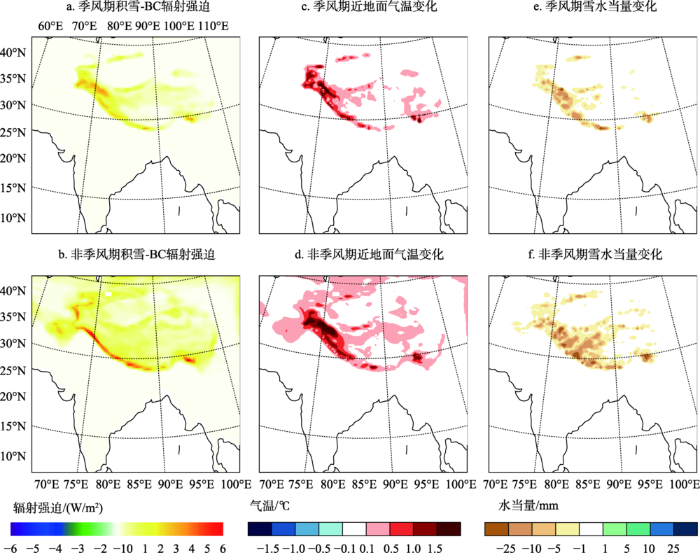
虽然大气中BC可产生直接辐射效应,但由于高原BC的浓度仍较低,高原大气气溶胶的气候效应相对较小。而BC通过干、湿沉降过程降落到雪冰表面形成杂质,由于吸光性杂质和雪冰颗粒之间质量消光系数的巨大差异,少量杂质就能显著地降低雪冰反照率。反照率降低意味着雪冰对太阳辐射吸收增强,温度升高,从而加速雪冰消融。但之前模拟研究大多数未关注吸光性杂质对雪冰的辐射反馈效应,因此我们在区域气候模式egCM4.3中耦合了雪冰—气溶胶辐射传输模块,以评估青藏高原雪冰吸光性杂质对气候的影响,扩展了模拟评估吸光性物质对雪冰影响的新技术方法。结果表明,非季风期BC和有机质的沉降通量显著高于季风期,季风期高原西部及喜马拉雅山地区的BC与有机质沉降通量显著高于高原其他地区,非季风期雪冰中BC与有机质的沉降通量在高原地区呈现外缘高,内陆低的空间分布特征。这种分布特征由于青藏高原自身的排放极低,而大气中污染物主要由高原以外的地区的远距离传输进入,受到地形阻挡,形成了外缘高中间低的空间格局。BC导致雪冰反照率降低,季风期在高原西部产生的辐射强迫为3.0~4.5 W·m-2(图6a);非季风期喜马拉雅地区黑碳-雪冰辐射强迫为5.0~6.0 W·m-2(图6b);对于青藏高原西部及喜马拉雅地区,黑碳—雪冰辐射效应可导致近地面增温0.1~1.5°C(图6c, 6d),雪水当量减少5~25 mm(图6e, 6f) (Ji, 2016)。
图6 季风期黑碳导致雪冰辐射强迫(a), 气温(c) 和雪水当量(e)的变化 (b, d, f 同 a, c, e 但表示非季风期) (据(
Fig.6 The changes of surface snow radiative forcing (a), temperature (c), and snow water equivalent (e) induced by black carbon in monsoon season and non-monsoon (b, d, f) (Modified from
除人为源气溶胶外,作为自然源的粉尘也是雪冰杂质的重要组分,模拟结果表明(Ji et al, 2016),高原内陆及雅鲁藏布江大峡谷的起沙通量在过去20年呈减弱的趋势,这与高原地面风速减弱有一定关系。粉尘干、湿沉降受地形和南亚季风的影响较为显著,呈现出不同的季节和空间分布特征。在大气和雪冰中粉尘的共同作用下,青藏高原西部及昆仑山地区,春季地面升温0.1~0.5°C。在冬春季,粉尘导致高原西部、帕米尔、喜马拉雅地区的雪水当量减少5~25 mm。本项研究为丰富吸光性气溶胶对青藏高原气候系统及水循环过程的影响机理提供了理论依据。
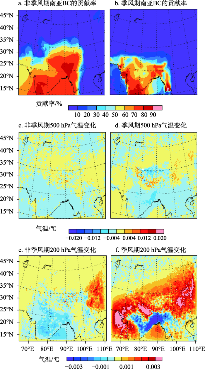
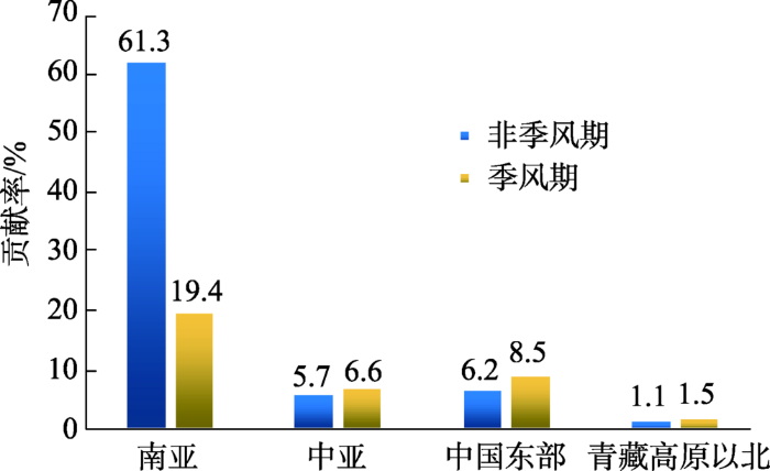
通过敏感性试验分析,发现青藏高原BC主要来自于南亚的人为排放(Yang et al, 2018)。非季风期青藏高原近地面BC的人为来源显著高于季风期,青藏高原有40%~80%(图7a)(区域平均为61.3%)的BC来自于南亚的人为排放;季风期(图7b)南亚的人为排放BC的贡献率为10%~50% (区域平均为19.4%)(图8)。中国中东部人为排放主要影响高原东部地区,季风期祁连山地区外源输送使BC浓度最大增加0.21 ug m-3,贡献率最高达50%。非季风期中亚人为排放对高原西部BC的贡献率最高达30% (平均为5.7%),与季风期的贡献率接近。中国北部人为排放对青藏高原近地面BC的影响不显著。高原BC的传输过程主要受气流影响,在非季风期,西风将中亚和印度北部的污染物传输进入高原。季风期,南亚地区存在辐合上升气流,将下层的气溶胶向上输送到中高层,随西南风翻越喜马拉雅山脉,进入到高原内陆。来自南亚的BC可导致青藏高原大气气温发生变化。非季风期,大气层在500 hPa整个高原表现为增温(图7c);而季风期在高原北部为降温,南部及喜马拉雅山地区表现为增温(图7d),在200 hPa高度(图7e),BC在季风期对大气有显著的增温作用(图7f)。
图7 非季风期南亚BC的贡献率(a)及对500 hPa(c), 200 hPa(e)气温的影响, (b, d, f 同 a, c, e 但表示非季风期) (据Yang
Fig.7 Contribution rate of black carbon from South Asia (a) and its climatic effects on temperature at the 500 hPa (c) and 200 hPa (e) levels in monsoon (b, d, f) and non-monsoon season (a, c, e) (Modified from
图8 非季风期、季风期南亚、中亚、中国东部及青藏高原以北地区BC输入青藏高原的贡献率。
Fig.8 The concentration rates of black carbon transported from South Asia, Central Asia, eastern China, and the area north of the Tibetan Plateau
以青藏高原为主体的第三极地区,是地球上除南北极之外最洁净的区域,但也不可避免受污染物的影响,跨境输入的污染物已成为威胁本区域环境和生态系统不可忽视的重要因素之一。基于模式模拟方法,青藏高原大气黑碳外源输送及其气候效应的研究取得了一些初步的进展,但仍面临诸多亟需解决的问题:
(1) 模式的性能亟待提高。随着计算机技术的发展,模式的物理过程、分辨率及计算并行效率较之前有了大幅度的提升,然而仍存在一些不足,包括:降水的模拟效果较差;模式陆面过程较粗糙;缺少气溶胶间接和半间接效应等。以上问题直接影响到气溶胶模拟的准确性,同时导致模拟结果存在较大的不确定性。因此,未来基于模式开展本区域大气气溶胶传输及气候效应的模拟研究,应从以下四个方面入手提升模式的模拟精度:a) 构建覆盖第三极地区的高分辨率大气污染物排放清单。排放清单是模式模拟污染物浓度分布和传输的输入数据,由于青藏高原及其周边区域长期缺乏监测数据,目前模式中使用的排放清单存在较大的偏差。b) 改进模式的参数方案:包括陆面过程、积云对流和边界层参数。改进陆面过程和积云对流参数,可在一定程度上提高模式对降水的模拟能力;对边界层参数的优化主要是针对第三极地区复杂的地形条件与特殊的边界层结构,通过观测资料对混合层参数化方案中的一些经验参数进行优化,改进模式对气溶胶模拟的精度。c) 丰富模式的物理过程。如通过在线/离线耦合的方式,考虑气溶胶对冰川消融的影响及气溶胶—云相互作用等,以上过程在过去的研究中涉及较少,但这些物理过程作为区域气候的影响因子是不可忽视的。d) 进一步提高模式分辨率。特殊地形(如山地、高原),往往造成区域气候的特殊变化规律,模拟分辨率的提高可使模式捕捉到复杂地形环境下局地强迫的影响,从而对青藏高原气候有更好的再现和模拟能力。
(2) 开展多尺度污染物的数值模拟研究。大气污染物的传输过程在空间上既包括大尺度也包括中小尺度,而当前的研究中多数只考虑单一尺度的传输过程。如在有限区域内使用动力降尺度的方法,虽然分辨率提高后较全球模式能更好地显示地形对污染物的阻挡作用,但并不适用于全球尺度传输的大污染物。另外,虽然区域模式的分辨率较高,但难以体现精细化的地表过程。如在喜马拉雅山脉南坡,白天盛行从下向上的谷风,将污染物从低海拔地区输送到高海拔地区;而在喜马拉雅山脉北坡,由于分布着大面积的冰川,导致下沉的冰川风克服了上升的谷风,南北坡的局地环流使山谷成为污染物传输的可能通道。目前模拟手段都难以捕捉到污染物沿着山谷迁移的过程,无法判定其输入通量,难以量化山谷输送与高空翻越这两种途径对于污染物跨境迁移的相对贡献。因此,只有综合不同尺度和分辨率的模式,才能考虑不同高度、路径乃至不同种类污染物的传输过程。
(3) 观测数据和模拟方法的紧密结合。模式的评估和改进与观测数据的质量密切相关。用于订正参数化方案的观测数据大多是通过短期内的加密外场观测获得,在青藏高原及周边地区此类数据非常少,使得基于平原地区的参数化方案在高原并不适用。这些观测通常被认为是过程研究,通过将现场观测与遥感观测、过程模拟连接起来,系统地解决限制气候模式改进的关键问题。区域气候变化的成因是多方面的,如大尺度背景场的影响在某种程度上起主导作用,但特殊地形(如山地、高原)往往造成区域气候的特殊变化规律,亟需依托跨境观测网络,开展大气污染物多参数测试,为定量评估跨境污染物的输入奠定基础。目前迫切需要将多观测手段和模式模拟综合集成,最终给出全面、精确的来源和传输过程及机理,厘清各种污染物传输的影响范围。
The authors have declared that no competing interests exist.
| [1] |
亚洲夏季风是低层污染物进入平流层的重要途径 [J].https://doi.org/10.3878/j.issn.1006-9895.2011.05.09 URL Magsci [本文引用: 1] 摘要
夏季亚洲季风区是对流层低层水汽和污染物进入全球平流层的一个重要通道, 自然或人为污染物通过该通道进入平流层后对臭氧层的破坏以及全球气候环境的影响, 成为目前国际科学界关注的热点问题。早先观点认为: 夏季青藏高原是对流层低空物质向平流层输送的一个重要渠道。然而, 越来越多的观测表明: 包括青藏高原在内的整个亚洲夏季风通过强对流的快速输送以及大尺度输送过程可以把低层大气物质输送到全球平流层。在地面物质进入平流层的过程中有两个关键过程, 一是垂直快速输送的对流活动, 这对于短寿命化学成分非常重要, 二是缓慢的大尺度反气旋输送和限制作用。但是, 目前对于亚洲季风区不同源区的贡献还有很大的争议。
Tropospheric pollutant transport to the stratosphere by Asian summer monsoon [J].https://doi.org/10.3878/j.issn.1006-9895.2011.05.09 URL Magsci [本文引用: 1] 摘要
夏季亚洲季风区是对流层低层水汽和污染物进入全球平流层的一个重要通道, 自然或人为污染物通过该通道进入平流层后对臭氧层的破坏以及全球气候环境的影响, 成为目前国际科学界关注的热点问题。早先观点认为: 夏季青藏高原是对流层低空物质向平流层输送的一个重要渠道。然而, 越来越多的观测表明: 包括青藏高原在内的整个亚洲夏季风通过强对流的快速输送以及大尺度输送过程可以把低层大气物质输送到全球平流层。在地面物质进入平流层的过程中有两个关键过程, 一是垂直快速输送的对流活动, 这对于短寿命化学成分非常重要, 二是缓慢的大尺度反气旋输送和限制作用。但是, 目前对于亚洲季风区不同源区的贡献还有很大的争议。
|
| [2] |
青藏高原环境变化科学评估: 过去、现在与未来 [J].Assessment of past, present and future environmental changes on the Tibetan Plateau [J]. |
| [3] |
南亚地区黑碳气溶胶对亚洲夏季风的影响 [J].
<FONT face=Verdana>利用NCAR的全球大气模式CAM3, 模拟了南亚地区黑碳气溶胶对亚洲夏季风的影响。结果表明: 晚春时期, 南亚地区黑碳气溶胶强烈吸收太阳辐射, 加热低层大气, 造成孟加拉湾及沿岸地区雨季的提前, 可能导致南亚夏季风提前爆发。夏季, 被加热的大气沿青藏高原南坡爬升, 在高空形成一个稳定的加热层。高空的持续加热, 引起局地的深对流活动, 使得印度洋和南亚大陆之间产生一个北升南降的经圈环流, 导致印度洋洋面上的向北运动加强, 从而使南亚夏季风的强度增大。但是, 南亚地区黑碳气溶胶通过影响表面气压、 垂直运动、 降水和850 hPa风场等减弱了东亚夏季风, 且导致西太平洋副热带高压北移西伸, 使我国梅雨带位置向东北方向移动。</FONT>
Effects of black carbon aerosol in South Asia on Asian summer monsoon [J].
<FONT face=Verdana>利用NCAR的全球大气模式CAM3, 模拟了南亚地区黑碳气溶胶对亚洲夏季风的影响。结果表明: 晚春时期, 南亚地区黑碳气溶胶强烈吸收太阳辐射, 加热低层大气, 造成孟加拉湾及沿岸地区雨季的提前, 可能导致南亚夏季风提前爆发。夏季, 被加热的大气沿青藏高原南坡爬升, 在高空形成一个稳定的加热层。高空的持续加热, 引起局地的深对流活动, 使得印度洋和南亚大陆之间产生一个北升南降的经圈环流, 导致印度洋洋面上的向北运动加强, 从而使南亚夏季风的强度增大。但是, 南亚地区黑碳气溶胶通过影响表面气压、 垂直运动、 降水和850 hPa风场等减弱了东亚夏季风, 且导致西太平洋副热带高压北移西伸, 使我国梅雨带位置向东北方向移动。</FONT>
|
| [4] |
青藏高原及周边地区冰川中吸光性杂质及其影响研究进展 [J].
沉降到冰川表面的吸光性杂质(如黑碳、有机碳、粉尘等)对冰冻圈物质能量平衡具有重要影响.青藏高原及周边地区是冰川分布集中区,也是开展雪冰吸光性杂质对冰川消融影响研究的理想区域.基于近几年青藏高原及周边地区雪冰中吸光性杂质特别是黑碳的研究成果,综述了该区域雪冰中吸光性杂质的浓度水平与时空分布,着重探讨了黑碳的主要来源,阐明了吸光性杂质导致的辐射强迫及其对雪冰消融的影响,并指出目前研究中存在的问题以及未来研究的主要方向.目前,该地区冰川中吸光性杂质的空间差异大,同一冰川不同表面吸光性杂质分布特征研究匮乏;雪冰中吸光性杂质在冰川表面的迁移、富集等过程研究亟待加强;吸光性杂质对冰川反照率反馈以及冰川消融作用显著,但评估结果仍存在较大的不确定性.在未来,雪冰中吸光性杂质的混合状态、生物地球化学循环过程与气候变化的协同影响等将是一个新的研究方向.
Research progress of light-absorbing impurities in glaciers of the Tibetan Plateau and its surroundings [J].
沉降到冰川表面的吸光性杂质(如黑碳、有机碳、粉尘等)对冰冻圈物质能量平衡具有重要影响.青藏高原及周边地区是冰川分布集中区,也是开展雪冰吸光性杂质对冰川消融影响研究的理想区域.基于近几年青藏高原及周边地区雪冰中吸光性杂质特别是黑碳的研究成果,综述了该区域雪冰中吸光性杂质的浓度水平与时空分布,着重探讨了黑碳的主要来源,阐明了吸光性杂质导致的辐射强迫及其对雪冰消融的影响,并指出目前研究中存在的问题以及未来研究的主要方向.目前,该地区冰川中吸光性杂质的空间差异大,同一冰川不同表面吸光性杂质分布特征研究匮乏;雪冰中吸光性杂质在冰川表面的迁移、富集等过程研究亟待加强;吸光性杂质对冰川反照率反馈以及冰川消融作用显著,但评估结果仍存在较大的不确定性.在未来,雪冰中吸光性杂质的混合状态、生物地球化学循环过程与气候变化的协同影响等将是一个新的研究方向.
|
| [5] |
Historical trends of atmospheric black carbon on Tibetan Plateau as reconstructed from a 150-year lake sediment record [J].https://doi.org/10.1021/es3048202 URL PMID: 23402524 [本文引用: 1] 摘要
Black carbon (BC) is one of the key components causing global warming. Especially on the Tibetan Plateau (TP), reconstructing BC's historical trend is essential for better understanding its anthropogenic impact. Here, we present results from high altitude lake sediments from the central TP. The results provide a unique history of BC over the past 150 years, from the preindustrial to the modern period. Although BC concentration levels in the Nam Co Lake sediments were lower than those from other high mountain lakes, the temporal trend of BC fluxes clearly showed a recent rise, reflecting increased emissions from anthropogenic activities. The BC records were relatively constant until 1900, then began to gradually increase, with a sharp rise beginning around 1960. Recent decades show about 2.5-fold increase of BC compared to the background level. The emission inventory in conjunction with air mass trajectories further demonstrates that BC in the Nam Co Lake region was most likely transported from South Asia. Rapid economic development in South Asia is expected to continue in the next decades; therefore, the influence of BC over the TP merits further investigations.
|
| [6] |
Radiative forcing and albedo feedback from the Northern Hemisphere cryosphere between 1979 and 2008 [J].https://doi.org/10.1038/ngeo1062 URL [本文引用: 1] 摘要
The extent of snow cover and sea ice in the Northern Hemispherehas declined since 1979, coincident with hemispheric warming and indicative of a positive feedback of surface reflectivity on climate. This albedo feedback of snow on land has been quantified from observations at seasonal timescales, and century-scale feedback has been assessed using climate models. However, the total impact of the cryosphere on radiative forcing and albedo feedback has yet to be determined from measurements. Here we assess the influence of the Northern Hemisphere cryosphere on Earth's radiation budget at the top of the atmosphere--termed cryosphere radiative forcing--by synthesizing a variety of remote sensing and field measurements. We estimate mean Northern Hemisphere forcing at -4.6 to -2.2Wm, with a peak in May of -9.0+/-2.7Wm. We find that cyrospheric cooling declined by 0.45Wmfrom 1979 to 2008, with nearly equal contributions from changes in land snow cover and sea ice. On the basis of these observations, we conclude that the albedo feedback from the Northern Hemisphere cryosphere falls between 0.3 and 1.1WmK, substantially larger than comparable estimates obtained from 18 climate models.
|
| [7] |
Use of the RegCM system over East Asia: Review and perspectives [J].https://doi.org/10.1016/J.ENG.2017.05.019 URL [本文引用: 1] |
| [8] |
RegCM4: Model description and preliminary tests over multiple CORDEX domains [J].https://doi.org/10.3354/cr01018 URL [本文引用: 1] 摘要
A new version of the RegCM regional climate modeling system, RegCM4, has been recently developed and made available for public use. Compared to previous versions, RegCM4 includes new land surface, planetary boundary layer, and air ea flux schemes, a mixed convection and tropical band configuration, modifications to the pre-existing radiative transfer and boundary layer schemes, and a full upgrade of the model code towards improved flexibility, portability, and user friendliness. The model can be interactively coupled to a 1D lake model, a simplified aerosol scheme (including organic carbon, black carbon, SO4, dust, and sea spray), and a gas phase chemistry module (CBM-Z). After a general description of the model, a series of test experiments are presented over 4 domains prescribed under the CORDEX framework (Africa, South America, East Asia, and Europe) to provide illustrative examples of the model behavior and sensitivities under different climatic regimes. These experiments indicate that, overall, RegCM4 shows an improved performance in several respects compared to previous versions, although further testing by the user community is needed to fully explore its sensitivities and range of applications.
|
| [9] |
Modeling black carbon and its potential radiative effects over the Tibetan Plateau [J].https://doi.org/10.1016/j.accre.2016.10.002 URL [本文引用: 4] 摘要
A regional climate model (RegCM4.3.4) coupled with an aerosol–snow/ice feedback module was used to simulate the deposition of anthropogenic light-absorbing impurities in snow/ice and the potential radiative feedback of black carbon (BC) on temperature and snow cover over the Tibetan Plateau (TP) in 1990–2009. Two experiments driven by ERA-interim reanalysis were performed, i.e., with and without aerosol–snow/ice feedback. Results indicated that the total deposition BC and organic matter (OM) in snow/ice in the monsoon season (May–September) were much more than non-monsoon season (the remainder of the year). The great BC and OM deposition were simulated along the margin of the TP in the non-monsoon season, and the higher deposition values also occurred in the western TP than the other regions during the monsoon period. BC-in-snow/ice decreased surface albedo and caused positive surface radiative forcing (SRF) (3.0–4.502W02m-2) over the western TP in the monsoon season. The maximum SRF (5–602W02m-2) simulated in the Himalayas and southeastern TP in the non-monsoon season. The surface temperature increased by 0.1–1.502°C and snow water equivalent decreased by 5–2502mm over the TP, which showed similar spatial distributions with the variations of SRF in each season. This study provided a useful tool to investigate the mechanisms involved in the effect of aerosols on climate change and the water cycle in the cryospheric environment of the TP.
|
| [10] |
Double nested dynamical downscaling experiments over the Tibetan Plateau and their projection of climate change under two RCP scenarios [J].https://doi.org/10.1175/JAS-D-12-0155.1 URL [本文引用: 2] 摘要
A high-resolution regional climate model is used to simulate climate change over the Tibetan Plateau (TP). The model is driven at the grid spacing of 10 km by nesting the outputs of 50-km-resolution simulations. The results show that the models can capture the spatial and temporal distributions of the surface air temperature over the TP. The so-called double-nested method has a higher horizontal resolution and represents more spatial details. For example, the temperature simulations from the double-nested method reflect the observations better compared to the 50-km-resolution models. This is mainly due to the fact that topographical effects of complex terrains are detected better at higher resolution. Although both models can represent the basic patterns of precipitation, the simulated results are not as good as those of temperature. In the future, significant warming seems to develop over the TP under two representative concentration pathway (RCP) scenarios. Greater increases occur in December-February (DJF) compared with June-August (JJA). The increasing temperature trend is more pronounced over the Gangdese Mountains and over the Himalayas than in the central TP. The projection of precipitation shows the main increases in DJF. In JJA, it predicts decreases or slight changes in the southern TP. The comparison between RCP8.5 and RCP4.5 scenarios shows a similar spatial distributions of temperature and precipitation, whereas the respective values of RCP8.5 are enhanced compared with those under RCP4.5.
|
| [11] |
Evaluation of extreme climate events using a regional climate model for China [J].https://doi.org/10.1002/joc.4024 URL [本文引用: 5] 摘要
ABSTRACT Extreme climate events over China at the end of the 21st century (2080–2099) are investigated using the regional climate model RegCM4. Model performance is validated through comparison between observations and simulations over the period 1985–2005. The results show that RegCM4 can satisfactorily reproduce the spatial distribution of extreme climate events over China. The model simulates temperature extremes more accurately than precipitation. Under the RCP8.5 (high emission) scenario, the number of frost days decreases, and both the heat wave duration index and the growing season length increase dramatically towards the end of the 21st century. Changes in extreme temperature become increasingly pronounced from South to North China, with the most significant changes occurring on the Tibetan Plateau (TP). The proportion of heavy precipitation generally increases, except on the southern TP. The number of very heavy precipitation days increases by 25–50% in Northwest and East China. In winter, the number of consecutive dry days (CDD) decreases in North China and increases in South China. The greatest increases in CDD are found in June, July and August (JJA) in Southwest China. In a future that follows this scenario, drought events may be aggravated in Southwest China, and decrease in North China. In contrast, when repeating these projections under the assumption of the RCP4.5 scenario for emissions, the frequency of extreme climate events is reduced. These results suggest that reductions in greenhouse gas emissions may mitigate the effects of climate change over the coming decades.
|
| [12] |
Simulation of carbonaceous aerosols over the Third Pole and adjacent regions: Distribution, transportation, deposition, and climatic effects [J].https://doi.org/10.1007/s00382-015-2509-1 URL [本文引用: 2] 摘要
Carbonaceous aerosols including black carbon and organic carbon over the Third Pole regions are simulated using a regional climate model (RegCM4.3) coupled with a chemistry–aerosol module. Results show that the model can simulate well the climatology of the Third Pole region in monsoon and non-monsoon seasons, but the model shows a cold bias and an overestimation of precipitation over the Himalayas and the northern Tibetan Plateau. The model also performs reasonably well in terms of aerosol optical depth and near surface aerosol concentration when compared with satellite datasets and in situ observations. BC wet deposition in monsoon seasons is more (less) than that in non-monsoon seasons in the southern (northwestern) parts of the Third Pole region. Westerly winds prevail throughout the year and transport carbonaceous particles from central Asia to the northern Tibetan Plateau. In the monsoon period, aerosols can cross the Himalayas and can be transported to high altitudes by the southwesterly winds over South Asia. Dry deposition shows a topography-controlled distribution, with low fluxes within and high fluxes outside of the Tibetan Plateau. Mixed carbonaceous aerosols produce positive shortwave radiative forcing in the atmosphere and negative forcing at the surface. Shortwave forcing is with less magnitude over the Third Pole region. Longwave radiation forcing is negative over the Pamir Plateau and positive over the Tibetan Plateau during monsoon season. In non-monsoon season, longwave radiative forcing is negative in the Himalayas and southern parts of the Tibetan Plateau. Aerosols increase surface air temperatures by 0.1–0.502°C over the Tibetan Plateau and decrease temperatures in South Asia during the monsoon season. In the non-monsoon period, temperatures decrease by 0.1–0.502°C over the southern Tibetan Plateau. Spatial changes in temperature are consistent with the distribution of longwave radiative forcing, which indicates that aerosols’ longwave radiative forcing probably plays an important role in the climatic impact of aerosols over the Third Pole region.
|
| [13] |
Simulation of the anthropogenic aerosols over South Asia and their effects on Indian summer monsoon [J].https://doi.org/10.1007/s00382-010-0982-0 URL [本文引用: 2] 摘要
A regional climate model coupled with a chemistry-aerosol model is employed to simulate the anthropogenic aerosols including sulfate, black carbon and organic carbon and their direct effect on climate over South Asia. The model is driven by the NCAR/NCEP re-analysis data. Multi-year simulations with half, normal and double emission fluxes are conducted. Results show that the model performs well in reproducing present climate over the region. Simulations of the aerosol optical depth and surface concentration of aerosols are also reasonable although to a less extent. The negative radiative forcing is found at the top of atmosphere and largely depended on emission concentration. Surface air temperature decreases by 0.1–0.5°C both in pre-monsoon and monsoon seasons. The range and intensity of cooling areas enlarge while aerosol emission increases. Changes in precipitation are between 6125 and 25%. Different diversifications of rainfall are showed with three emission scenarios. The changes of precipitation are consistent with varieties of monsoon onset dates in pre-monsoon season. In the regions of increasing precipitation, monsoon onset is advanced and vice versa. In northeast India and Myanmar, aerosols lead the India summer monsoon onset advancing 1–2 pentads, and delaying by 1–2 pentads in central and southeast India. These changes are mainly caused by the anomaly of local Hadley circulations and enhancive precipitation. Tibetan Plateau played a crucial role in the circulation changes.
|
| [14] |
Investigation of mineral aerosols radiative effects over High Mountain Asia in 1990-2009 using a regional climate model [J].https://doi.org/10.1016/j.atmosres.2016.05.003 URL [本文引用: 1] 摘要
61Dust climatic effects including aerosol–snow feedback was online simulated.61The radiative forcing due to dust deposition on snow was diagnosed by the model.61Long-term variabilities of dust radiative effects were investigated in 1990–2009.
|
| [15] |
Atmospheric black carbon and its effects on cryosphere [J].https://doi.org/10.1016/j.accre.2016.09.005 URL [本文引用: 1] 摘要
Black carbon (BC) is formed from the incomplete combustion of fossil fuels (e.g. coal and diesel oil), biofuel and biomass (like wildfires). As the most strongly light-absorbing component of atmospheric aerosols, BC could heat the atmosphere efficiently (i.e. the direct radiative forcing). Atmospheric BC also interacts with clouds to change cloud cover,lifetime, and brightness. Recently, the impact of BC on the cryosphere received increasing attention, because it could result in the significant glacier/snow cover melt through both the atmospheric warming and also the albedo reduction after its deposition on surface of snow/ice. Therefore, the importanceof BC as the major forcing in the climate system has been highlighted in the Fifth Assessment Report of IPCC.However, substantial uncertainty regarding its spatial-temporal distribution and climate effect still remains.
|
| [16] |
Atmospheric mercury depositional chronology reconstructed from lake sediments and ice core in the Himalayas and Tibetan Plateau [J].https://doi.org/10.1021/acs.est.5b04172 URL PMID: 26878654 [本文引用: 1] 摘要
Alpine lake sediments and glacier ice cores retrieved from high mountain regions can provide long-term records of atmospheric deposition of anthropogenic contaminants such as mercury (Hg). In this study, eight lake sediment cores and one glacier ice core were collected from high elevations across the Himalaya ibet region to investigate the chronology of atmospheric Hg deposition. Consistent with modeling results, the sediment core records showed higher Hg accumulation rates in the southern slopes of the Himalayas than those in the northern slopes in the recent decades (post-World War II). Despite much lower Hg accumulation rates obtained from the glacier ice core, the temporal trend in the Hg accumulation rates matched very well with that observed from the sediment cores. The combination of the lake sediments and glacier ice core allowed us to reconstruct the longest, high-resolution atmospheric Hg deposition chronology in High Asia. The chronology showed that the Hg deposition rate was low between the 1...
|
| [17] |
Review of climate and cryospheric change in the Tibetan Plateau [J].https://doi.org/10.1088/1748-9326/5/1/015101 URL [本文引用: 1] |
| [18] |
Sources of black carbon to the Himalayan-Tibetan Plateau glaciers [J].https://doi.org/10.1038/ncomms12574 URL PMID: 4996979 [本文引用: 1] 摘要
Combustion-derived black carbon (BC) aerosols accelerate glacier melting in the Himalayas and in Tibet (the Third Pole (TP)), thereby limiting the sustainable freshwater supplies for billions of people. However, the sources of BC reaching the TP remain uncertain, hindering both process understanding and efficient mitigation. Here we present the source-diagnostic Δ14C/δ13C compositions of BC isolated from aerosol and snowpit samples in the TP. For the Himalayas, we found equal contributions from fossil fuel (46±11%) and biomass (54±11%) combustion, consistent with BC source fingerprints from the Indo-Gangetic Plain, whereas BC in the remote northern TP predominantly derives from fossil fuel combustion (66±16%), consistent with Chinese sources. The fossil fuel contributions to BC in the snowpits of the inner TP are lower (30±10%), implying contributions from internal Tibetan sources (for example, yak dung combustion). Constraints on BC sources facilitate improved modelling of climatic patterns, hydrological effects and provide guidance for effective mitigation actions. Black carbon accelerates melting of glaciers in the Himalayas and Tibet, yet the source of these aerosols remains enigmatic. Here, the authors use isotope fingerprinting techniques to determine the origin of black carbon preserved in glacier ice cores recovered from the Himalayas and Tibetan Plateau.
|
| [19] |
Atmospheric brown clouds reach the Tibetan Plateau by crossing the Himalayas [J].https://doi.org/10.5194/acpd-14-28105-2014 URL [本文引用: 1] 摘要
The Himalayas and the Tibetan Plateau region (HTP), despite being a remote and sparsely populated area, is regularly exposed to polluted air masses with significant amounts of aerosols including black carbon. These dark, light-absorbing particles are known to exert a great melting potential on mountain cryospheric reservoirs through albedo reduction and radiative forcing. This study combines the available yet sparse ground-based and satellite data to identify a severe aerosol pollution episode observed simultaneously in central Tibet and on the southern side of the Himalayas during 13 19 March 2009. We detail how polluted air masses such as an atmospheric brown cloud (ABC) over South Asia reached the Tibetan Plateau during this pre-monsoon case study. In order to address the mechanisms of pollution transport in the complex topography of the HTP, air-mass trajectories are calculated using hourly outputs from the high-resolution numerical weather prediction model COSMO. Cross-mountain pollution transport is found to occur to a large extent at elevated tropospheric levels other than just through major river valleys. Lifting and advection of polluted air masses over the great mountain range is enabled by a combination of synoptic and local meteorological settings. Winds over the Indo Gangetic Plain (IGP) are generally weak at lower levels during the event, allowing for accumulation of pollutants. The passing of synoptic-scale troughs leads to south-westerly flow in the middle troposphere over northern and central India. Thus, ABC can build up south of the Himalayas and get carried northwards across the mountain range and onto the Tibetan Plateau as the winds obtain a southerly component. Air masses from the ABC hot-spot of the IGP can reach the high glaciers, which may have serious implications for the cryosphere in the HTP region and for climate on regional to global scales.
|
| [20] |
Effects of mineral aerosols on the summertime climate of southwest Asia: Incorporating subgrid variability in a dust emission scheme [J].https://doi.org/10.1029/2010JD014036 URL [本文引用: 1] 摘要
[1] Improvements in modeling mineral aerosols over southwest Asia are made to the dust scheme in a regional climate model by representing subgrid variability of both wind speed and surface roughness length. The new module quantifies wind variability by using model meteorology while assuming that wind speed follows a Gaussian distribution. More specifically, wind variability is approximated by dry convective eddies within the planetary boundary layer, forced by sensible heat fluxes at the surface. Incorporating subgrid variability of wind increases aerosol optical depth (AOD) over the region by nearly 35% while reducing incoming shortwave radiation by an additional 5 10 W/m 2 . Likewise, the dust scheme is modified to include the variability of surface roughness length over southwest Asia. Here an empirical distribution of roughness length for each grid cell is calculated based on the USGS's 4 km resolution land cover data set. However, incorporating roughness length variability does not significantly alter dust emissions over the region due to the relatively homogeneous land cover conditions. Nevertheless, including spatial variability for wind results in aerosol optical depth values closer to observational data sets, particularly MISR, which performs better than MODIS over this region. However, RegCM3's dust model still underestimates AOD over southwest Asia. In addition to improvements made in RegCM3's dust model, this work examines the effects of mineral aerosols on the mean monthly, surface summertime climate of southwest Asia. It is shown that dust emissions reduce average summertime surface temperatures by approximately 0.5 C while attenuating shortwave incident radiation by nearly 25 W/m 2 . Thus, the emission of dust is an important surface process in shaping the summertime climate over southwest Asia. However, both a warm bias in surface temperatures and overestimation of incoming shortwave radiation still exist in RegCM3 and need to be further addressed.
|
| [21] |
Tibetan Plateau Geladaindong black carbon ice core record (1843-1982): Recent increases due to higher emissions and lower snow accumulation [J].https://doi.org/10.1016/j.accre.2016.07.002 URL [本文引用: 1] 摘要
Black carbon (BC) deposited on snow and glacier surfaces can reduce albedo and lead to accelerated melt. An ice core recovered from Guoqu glacier on Mt. Geladaindong and analyzed using a Single Particle Soot Photometer (SP2) provides the first long-term (1843 1982) record of BC from the central Tibetan Plateau. Post 1940 the record is characterized by an increased occurrence of years with above average BC, and the highest BC values of the record. The BC increase in recent decades is likely caused by a combination of increased emissions from regional BC sources, and a reduction in snow accumulation. Guoqu glacier has received no net ice accumulation since the 1980s, and is a potential example of a glacier where an increase in the equilibrium line altitude is exposing buried high impurity layers. That BC concentrations in the uppermost layers of the Geladaindong ice core are not substantially higher relative to deeper in the ice core suggests that some of the BC that must have been deposited on Guoqu glacier via wet or dry deposition between 1983 and 2005 has been removed from the surface of the glacier, potentially via supraglacial or englacial meltwater.
|
| [22] |
Simulation of south Asian aerosols for regional climate studies [J].https://doi.org/10.1029/2011JD016711 URL [本文引用: 1] 摘要
[1] Extensive intercomparison of columnar and near-surface aerosols, simulated over the South Asian domain using the aerosol module included in the regional climate model (RegCM4) of the Abdus Salam International Centre for Theoretical Physics (ICTP) have been carried out using ground-based network of Sun/sky Aerosol Robotic Network (AERONET) radiometers, satellite sensors such as Moderate Resolution Imaging Spectroradiometer (MODIS) and Multiangle Imaging Spectroradiometer (MISR), and ground-based black carbon (BC) measurements made at Aerosol Radiative Forcing over India (ARFI) network stations. In general, RegCM4 simulations reproduced the spatial and seasonal characteristics of aerosol optical depth over South Asia reasonably well, particularly over west Asia, where mineral dust is a major contributor to the total aerosol loading. In contrast, RegCM4 simulations drastically underestimated the BC mass concentrations over most of the stations, by a factor of 2 to 5, with a large spatial variability. Seasonally, the discrepancy between the measured and simulated BC tended to be higher during winter and periods when the atmospheric boundary layer is convectively stable (such as nighttime and early mornings), while during summer season and during periods when the boundary layer is convectively unstable (daytime) the discrepancies were much lower, with the noontime values agreeing very closely with the observations. A detailed analysis revealed that the model does not reproduce the nocturnal high in BC, observed at most of the Indian sites especially during winter, because of the excessive vertical transport of aerosols under stable boundary layer conditions. As far as the vertical distribution was concerned, the simulated vertical profiles of BC agreed well with airborne measurements during daytime. This comprehensive validation exercise reveals the strengths and weaknesses of the model in simulating the spatial and temporal heterogeneities of the aerosol fields over South Asia.
|
| [23] |
Regional climate modeling for the developing World: The ICTP RegCM3 and RegCNET [J].https://doi.org/10.1175/BAMS-88-9-1395 URL [本文引用: 1] 摘要
The article discusses a climate modeling program taken up by the Abdus Salam International Centre for Theoretical Physics (ICTP) for conducting climatic research in economically developing nations (EDNs). It points out the different reasons for climate change that affects people in EDNs. The climate models, both global and regional, are the primary tools that help in understanding many processes of the climate system. It is stated that the decreasing cost of computing devices has allowed scientists in EDNs to develop climate simulation models for weather forecasting and research. A detailed account of a regional climate model (RCM) developed by the ICTP is given. Finally the article provides information on the way these climate models function which is depicted by satellite photographs.
|
| [24] |
Light-absorbing particles in snow and ice: Measurement and modeling of climatic and hydrological impact [J].https://doi.org/10.1007/s00376-014-0010-0 URL [本文引用: 1] |
| [25] |
Global and regional climate changes due to black carbon [J].https://doi.org/10.1038/ngeo156 URL [本文引用: 1] |
| [26] |
Warming trends in Asia amplified by brown cloud solar absorption [J].https://doi.org/10.1038/nature06019 URL PMID: 17671499 [本文引用: 1] 摘要
Atmospheric brown clouds are mostly the result of biomass burning and fossil fuel consumption. They consist of a mixture of light-absorbing and light-scattering aerosols and therefore contribute to atmospheric solar heating and surface cooling. The sum of the two climate forcing terms-the net aerosol forcing effect-is thought to be negative and may have masked as much as half of the global warming attributed to the recent rapid rise in greenhouse gases. There is, however, at least a fourfold uncertainty in the aerosol forcing effect. Atmospheric solar heating is a significant source of the uncertainty, because current estimates are largely derived from model studies. Here we use three lightweight unmanned aerial vehicles that were vertically stacked between 0.5 and 3 km over the polluted Indian Ocean. These unmanned aerial vehicles deployed miniaturized instruments measuring aerosol concentrations, soot amount and solar fluxes. During 18 flight missions the three unmanned aerial vehicles were flown with a horizontal separation of tens of metres or less and a temporal separation of less than ten seconds, which made it possible to measure the atmospheric solar heating rates directly. We found that atmospheric brown clouds enhanced lower atmospheric solar heating by about 50 per cent. Our general circulation model simulations, which take into account the recently observed widespread occurrence of vertically extended atmospheric brown clouds over the Indian Ocean and Asia, suggest that atmospheric brown clouds contribute as much as the recent increase in anthropogenic greenhouse gases to regional lower atmospheric warming trends. We propose that the combined warming trend of 0.25 K per decade may be sufficient to account for the observed retreat of the Himalayan glaciers.
|
| [27] |
Radiative and climatic effects of dust over West Africa, as simulated by a regional climate model [J].https://doi.org/10.3354/cr01039 URL [本文引用: 1] 摘要
We used the Regional Circulation Model (RegCM) to investigate the direct effect of dust aerosol on climate over West Africa, with a specific focus on the Sahel region. First, we characterized the mechanisms linking dust radiative forcing and convective activity over Sahel and the net impact of dust on precipitation: The mean effect of dust over 11 summer seasons is to reduce precipitation over most of the Sahel region as a result of strong surface cooling and elevated diabatic warming inhibiting convection. However, on the very northern Sahel and in the vicinity of dust sources, a relative increase of precipitation is obtained as a result of enhanced diabatic warming in the lower atmosphere associated with high dust concentrations at low altitude. In the second part of the paper, we investigated the robustness of this signal with regards to different modeling conditions that are thought to be sensitive, namely the extension of the domain, the effect of dust on sea surface temperature, the land surface scheme, the convective scheme and the dust single scattering albedo. The simulated dust induced precipitation anomaly over West Africa is consistent and robust in these tests, but significant variations over the northern Sahel region are nevertheless pointed out. Among different factors, single scattering and surface albedo, as well as the nature of the convective scheme, have the greatest influence on the simulated response of West African climate to dust forcing
|
| [28] |
Baseline continental aerosol over the central Tibetan plateau and a case study of aerosol transport from South Asia [J].https://doi.org/10.1016/j.atmosenv.2011.07.067 URL [本文引用: 1] 摘要
Using 22 months of sunphotometer observations at Nam Co, an Aerosol Robotic Network (AERONET) site located in the central Tibetan Plateau, the background level of aerosol in this remote continental site was analyzed for the first time. An extraordinary pollution episode with an aerosol optical depth at 50002nm ( τ) of an order of magnitude higher than the baseline was further studied using ground-based and satellite remote-sensing data. The annual aerosol baseline at Nam Co is τ02=020.029, which is about half of that over the Pacific Ocean and the Atlantic Ocean. Sunphotometer observations at Nam Co recorded an intense spring atmospheric pollution episode, with the maximum τ of 0.42 on 16 March 2009. The episode was02characterized by dominant fine particles with strong absorption. A large τ value with similar size and absorption also occurred in the Indo-Gangetic plains and South Asia, suggesting the transportation of aerosols to the Tibetan Plateau from surrounding regions. The passive satellite data showed dense plumes associated with active fires in the Himalayan foothills, the Indo-Gangetic plains, and South Asia and a thick, widespread haze piling up against the Himalayan ridges and impinging upon adjacent valleys. A pollution pool with a thick layer rich with aerosol over the Ganges Plain in Northern India, as revealed by the active02satellite data, extended up to 3–502km during this period, making it possible for the transportation of aerosols to the central Tibetan Plateau by the southwesterly wind prevailing at that level. Further studies are urgently required to identify the transport mechanism and to reveal the potential climatic impacts of aerosol transportation to the Tibetan Plateau.
|
| [29] |
Potential feedback between aerosols and meteorological conditions in a heavy pollution event over the Tibetan Plateau and Indo-Gangetic Plain [J].https://doi.org/10.1007/s00382-016-3240-2 URL [本文引用: 3] 摘要
A regional climate model WRF-Chem was used to investigate the feedback between aerosols and meteorological conditions in atmospheric boundary layer over the Tibetan Plateau (TP) and Indo-Gangetic Plain (IGP). The numerical experiments with and without the aerosol effects are driven by reanalysis from March 1-31, 2009, when a heavy pollution event (March 13-19) occurred. Results showed that the model can capture the spatial and temporal meteorological conditions and aerosols optical characteristics during the heavy pollution days. Aerosols induce cooling at the surface and warming in the middle of troposphere due to their radiative effects, and result in the atmospheric boundary layer (ABL) trend to more stable over the IGP. Aerosols-induced 2-meter relative humidity (RH2) is increased, which superposes the stable ABL lead to the surface PM2.5 concentration increases by up to 21 ug m-3 (15%) over the IGP. For the TP, the atmospheric profile does not change too much due to the fewer aerosols' radiative effects in the ABL comparing to those over the IGP. The aerosols-induced RH2 decreases because of the cloud albedo and cloud lifetime effect and leads to the surface PM2.5 concentration reduce up to 17 ug m-3 (13%). It is implicated that a negative/positive feedback between aerosols concentration and changes of aerosol-induced meteorological conditions over the TP/IGP, which is like/unlike the situations in other heavy polluted regions (e.g., the North China Plain). The results have a potential implication of air pollution on weather and environment over the TP and IGP.
|
| [30] |
Modeling the origin of anthropogenic black carbon and its climatic effect over the Tibetan Plateau and surrounding regions [J].https://doi.org/10.1002/2017JD027282 URL [本文引用: 6] 摘要
Abstract Black carbon (BC) in snow/ice induces enhanced snow and glacier melting. As over 60% of atmospheric BC is emitted from anthropogenic sources, which directly impacts the distribution and concentration of BC in snow/ice, it is essential to assess the origin of anthropogenic BC transported to the Tibetan Plateau (TP) where there are few direct emissions attributable to local human activities. In this study, we used a regional climate-atmospheric chemistry model and a set of BC scenarios for quantitative evaluation of the impact of anthropogenic BC from various sources and its climate effects over the TP in 2013. The results showed that the model performed well in terms of climatology, aerosol optical properties, and near-surface concentrations, which indicates that this modeling framework is appropriate to characterize anthropogenic BC source-receptor relationships over the TP. The simulated surface concentration associated with the anthropogenic sources showed seasonal differences. In the monsoon season, the contribution of anthropogenic BC was less than in the nonmonsoon season. In the nonmonsoon season, westerly winds prevailed and transported BC from central Asia and north India to the western TP. In the monsoon season, BC aerosol was transported to the middle-upper troposphere over the Indo-Gangetic Plain and crossed the Himalayas via southwesterly winds. The majority of anthropogenic BC over the TP was transported from South Asia, which contributed to 40% 80% (mean of 61.3%) of surface BC in the nonmonsoon season, and 10% 50% (mean of 19.4%) in the monsoon season. For the northeastern TP, anthropogenic BC from eastern China accounted for less than 10% of the total in the nonmonsoon season but can be up to 50% in the monsoon season. Averaged over the TP, the eastern China anthropogenic sources accounted for 6.2% and 8.4% of surface BC in the nonmonsoon and monsoon seasons, respectively. The anthropogenic BC induced negative radiative forcing and cooling effects at the near surface over the TP.
|
| [31] |
Simulation of dust aerosol and its regional feedbacks over East Asia using a regional climate model [J].https://doi.org/10.5194/acpd-8-4625-2008 URL [本文引用: 1] 摘要
The ICTP regional climate model (RegCM3) coupled with a desert dust model is used to simulate the radiative forcing and related climate effects of dust aerosols over East Asia. Two sets of experiments encompassing the main dust producing months, February to May, for 10 years (1997amp;ndash;2006) are conducted and inter-compared, one without (Exp. 1) and one with (Exp. 2) the radiative effects of dust aerosols. The simulation results are evaluated against ground station and satellite data. The model captures the basic observed climatology over the area of interest. The spatial and temporal variations of near surface concentration, mass load, and emission of dust aerosols from the main source regions are reproduced by model, with the main model deficiency being an overestimate of dust amount over the source regions and underestimate downwind of these source areas. Both the top-of-the-atmosphere (TOA) and surface radiative fluxes are decreased by dust and this causes a surface cooling locally up to amp;minus;1amp;deg;C. The inclusion of dust radiative forcing leads to a reduction of dust emission in the East Asia source regions, which is mainly caused by an increase in local stability and a corresponding decrease in dust lifting. Our results indicate that dust effects should be included in the assessment of climate change over East Asia.
|
| [32] |
Black carbon and mineral dust in snow cover on the Tibetan Plateau [J].https://doi.org/10.5194/tc-12-413-2018 URL [本文引用: 1] 摘要
The aim of this project is focused on developing an integral and novel electrodeionization system for the purpose of recovering and recycling valuable elements like precious and rare earth elements…" [more]
|

/
| 〈 |
|
〉 |

